GREATHIKES IN TENNESSEE STATE PARKS - Taken From The Tennessee Conservationist JANUARY/FEBRUARY 2005 Through JANUARY/FEBRUARY 2010 - Tennessee ...
←
→
Page content transcription
If your browser does not render page correctly, please read the page content below
G H
By Fran Wallas

REAT
I N T E N N E S S E E S TAT E PA R K S
                                                              IKES
    Taken From The Tennessee Conservationist JANUARY/FEBRUARY 2005 Through JANUARY/FEBRUARY 2010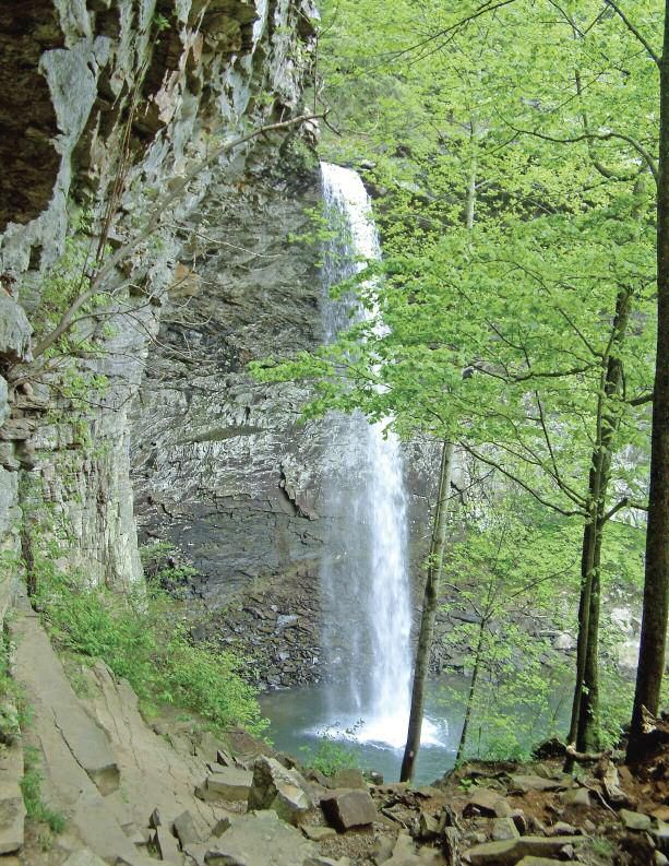
Department Colleagues and Friends Remember Fran Wallas (1952-2010)
      Fran had a lot of friends - friends of all sorts. The legal
 crew, the hiking crew, the symphony crew, the trail building
 crew - many circles. I was lucky enough to be on the lunch
 crew. As attorney for Tennessee State Parks, Fran provided the
 most unique client - legal counsel relationship in the history of
 such relationships. She absolutely loved parks, nature, the con-
 servation effort and Tennessee State Parks, in particular. Our
 best interest was always in her heart and mind. Her passion,
 coupled with her absolute integrity, made her the ideal lawyer
 for our organization. She knew what we were about and
 where we were trying to go. She always did her best to try and
 help us get there.

                  Jack Gilpin, Tennessee State Parks

      Fran was a Friend of Tennessee State Parks before it was even a concept as an organized group...She was a Friend of
 the Tennessee Trails Association...The Cumberland Trail Conference...The Tennessee Conservationist and many other
 entities. On many occasions she and I worked out legalities involving a variety of projects regarding state parks. Her dedi-
 cation to the preservation of the natural and wilderness areas of our state were constant and unflagging. She promoted the
 purchase of these natural treasures through many sources and means. Her support and expertise was always available
 when asked for. Always ready to help and make sure things were done right. She was also my Friend. It's difficult to think
 of not having Fran as a consultant, source of information, an inspiration, but most of all as my Friend.

                  Fount Bertram, Friends of Edgar Evins and Tennessee State Parks

                                                        I miss Fran every day. She was here when I arrived and here when I
                                                   went home at night. I've never known so much energy and determina-
                                                   tion to make things happen. Fran was game for any adventure. She was
                                                   fearless. She was so petite, but such a big presence. We went to a ranger
                                                   training program, and while I was headed to bed, she was going out to
                                                   do night time rappelling. Fran never doubted that she could make a dif-
                                                   ference in the world, and she did so in so many ways. It is my honor to
                                                   be her friend.

                                                                     Kim Kirk, TDEC Office of General Counsel

                                                        My favorite memories of Fran are when I would bring my son to the
                                                   office and she would drop everything and play with him. And it didn't
                                                   matter how long he stayed! She would teach him about nature and let
                                                   him play with all the little frogs that she collected. I thank God for the
                                                   privilege of having known her and being able to call her my friend.

                                                                     Devin Wells, TDEC Office of General Counsel
January 5, 2011

       Our department and the community of explorers lost a sharp legal mind, stalwart champion for state parks and tire-
  less trailbuilder with the death of Fran Wallas in October 2010. In Fran’s passing, the Tennessee Conservationist family
  also lost a dedicated and long-time contributor of appreciated hiking articles. From Jan/Feb 2005 through Nov/Dec
  2010, Fran authored a series of Great Hikes articles that shared her favorite Tennessee State Park trail experiences. In re-
  sponse to many requests and in honor of Fran, it is our pleasure to compile all 36 of these trail experiences in a one-
  time, limited edition printing of Great Hikes in Tennessee State Parks.
       Fran received the prestigious 2010 Bob Brown Lifetime Achievement Award from the Tennessee Trails Association
  posthumously on November 13, 2010, at Paris Landing State Park. I believe this well-deserved honor aptly captured
  Fran’s impact on our state as a champion of its parks and trails; an author guiding visitors to its special places; and a
  builder of the Cumberland Trail.
       Fran had a unique gift for bringing or gently leading others to experience nature. We hope this special issue of Great
  Hikes will introduce you to new outdoor adventures or remind you of an old friend you can meet back out on the trail.

                    Jam es H .Fyke
                    Commissioner, Tennessee Department of Environment and Conservation

      It is believed that Fran possibly knew every hiking trail in every TN state park. A few years ago my family spent a
weekend at a Tennessee State Park, on Saturday afternoon my son and I decided to hike one of the park's trails. With map in
hand, we began to follow the marked trail. However, after about an hour it began to dawn on us that we were possibly off
the trail and lost. We backtracked as best we could and eventually did make our way back to civilization. When I returned to
work the following Monday, I saw Fran and told her about getting lost on a park trail. She asked me which park and which
trail, and I told her. She asked "Did you come to a large tree where it was maybe a little bit confusing, like it seemed the trail
could lead off to the left, but you went straight instead?" I said I did recall that spot. She said, "Yeah, you should have gone
left. The markings are kind of faded, and if anybody gets lost on that trail, that's usually where it happens.” It is amazing she
was able to tell me exactly where we got lost!

                  Greg Teeple, TDEC Office of General Counsel

                 Acknowledgements
The Tennessee Department of Environment and
Conservation is grateful for the interest and sup-
port received from many individuals and locations
during the production of this special issue of Great
Hikes. We would like to specifically express our
appreciation for the following that made the proj-
ect possible:

David Wallas, Adam Wallas and Rebecca Arce:
Fran’s children
Dr. David Goldenberg: Fran’s brother
Louise Zepp, Editor, The Tennessee Conservationist
Jeff Law, Art Director, The Tennessee Conservationist
Douglas Printing
Special thanks to Shirley Ora for generously pro-
viding many photos of Fran out on the trail. Since
1984, Shirley hiked thousands of miles together with
Fran across Tennessee and all over the world.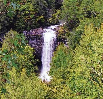
Intermediate Overnight Loop Trail at Mousetail Landing State Park
                      cenic views, a cedar glade,                              Now you are ready to hike from

            S         highly visible blue blazes in                          the office to the trailhead to begin

                                                              1
                      case of snow, and well-                                 your wilderness adventure. You
                maintained trail shelters make                                enter Kelly Hollow along a creek.
                Mousetail Landing State Park’s                                Your first surprise is that this hike
                eight-mile Intermediate                                      has a lot of steep ups and downs
                Overnight Loop Trail perfect for a                        through the woods. The next sur-
                winter hike.                                         prise is that you come to broad areas of
                      Mousetail Landing is near Linden on          flat open fields. When you get to a field,
                the east bank of the Tennessee River.              just look straight across and you will see
                      The trail offers a challenging backpack      the blaze and trail on the other side. Soon
                trail or a moderate day hike for an experi-        you will start seeing some big cedar trees.
                enced hiker.                                       There in the middle of this West Tennessee
                      Dedicated park staff lovingly care for       forest, you will discover a Middle Ten-
                this state park and make everything easy to        nessee type cedar glade.
                find. You will notice the carved trailhead               In about two miles, you reach the be-
                sign “Eagle Point Backpacking Trail” on            ginning of a loop. The trail to the right
                your right along the main park road. Con-          leads to shelter one. The trail to the left
                tinue a little further to the visitor center/of-   leads to shelter two. Both shelters are only
                fice parking.                                      about a mile from this junction. The
                      Registration is required for overnight       wooden shelters are screened and have

                                                                                                                      Fran Wallas
                camping at either of the two shelters. If you      sleeping platforms for eight people. Shelter
                are a day hiker, you may want to register          two is on a bluff with a scenic view of the
                for a river campsite or a wooded campsite          Tennessee River. This shelter is a wonder-
                                                                                                                                    The backpacking trail through the cedar
                at the top of the hill near the park office.       ful place to watch sunset. Shelter one is
                                                                                                                                    glade at Mousetail Landing State Park.
                      Campgrounds are open year round,             tucked in the woods and gives you a real                         Below,left: A campsite near the Tennessee
                but the shower and bathroom buildings are          feel of wilderness. When you are ready to                        River at Mousetail Landing State Park.
                closed in the winter.                              complete the loop, you will enjoy scenic
                      Take a “Mountain Bike Trail Map”             views of the creeks, river, and an occasional
                from the kiosk. The map includes all of            white tail of a fleeing deer. Although the
                the park’s biking and hiking trails. Back-         last part of the trail is a repeat of the first                               Directions
                packers need to carry lots of water be-            part, you will have a chance to notice what
                cause there is no water at the shelters.           you missed before. You will complete the                                The park is about halfway between
                You also need to be sure the water is pro-         hike and start thinking of seven people to                        Nashville and Memphis. If you are coming
                tected so that it does not freeze. The             invite along the next time.                                       from the east, take I- 40 to exit 143 and go
                                                                                                                                     south on Highway 13 to Linden. Turn right
                good news is that you can leave your tent                For information, call the park at 731-
                                                                                                                                     and go west on Highway 412 to Highway
                at home. The shelters will keep you dry            847-0841.                                                         438. If you are coming from the west, take I-
                and protected.                                                                                                       40 to exit 126 and go south on Highway 69.
                                                                                                                                     Turn left on Highway 412 and go east to
  Fran Wallas

                                                                                                                                     Highway 438. Now that you have found
                                                                                                                                     Highway 438, go about two miles, and you
                                                                                                                                     will notice a sign with arrows pointing left to
                                                                                                                                     the primitive camping area and boat ramp
                                                                                                                                     and an arrow pointing straight ahead to the
                                                                                                                                     main park entrance. Day hikers may choose
                                                                                                                                     to stop now to select a campsite along the
                                                                                                                                     Tennessee River. If you are anxious to begin
                                                                                                                                     your hike, don’t make that turn and continue
                                                                                                                                     until you get to the clearly marked entrance
                                                                                                                                     to the state park.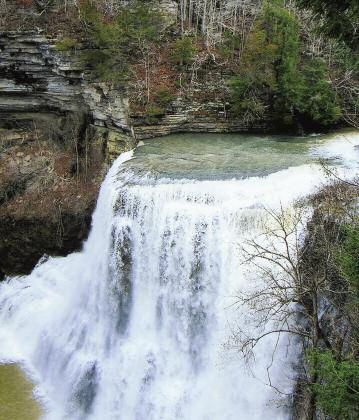
B e g i n n e r B a c k p a c k i n g H i k e t o H o r s e p o u n d Fa l l s
hike to Horsepound Falls at picnic. Pick a boulder and dangle
A the South Cumberland your feet in the water.
2
Recreation Area near If you want a longer hike,
Monteagle is an adventure re- you can wade across Rocky
warded by two waterfalls, an Mountain Creek below the falls
overlook, and a wonderful vari- and continue on toward Horse-
ety of wildflowers. pound Falls. The hike to Horse-
You can hike the trail in a day, but pound Falls is one of the best spring
you will enjoy it more if you spend the wildflower hikes. When you start wind-
night at West Collins Campground. ing down towards the Collins River, you
West Collins is one of the best be- will begin to notice the spring flowers.
ginner backpacking hikes. You reach Each week the flowers get better. There
the campsite in less than a half-mile, are waves of white early spring flowers
but you feel like you are out in the such as toothwort, chickweed, Spring
middle of a wilderness. You can drop Beauty and hepatica. The next week you
your pack, set up your tent, and fill up might see the mostly yellow colors of
water containers at the spring. If you Trout Lily, Dutchman’s Breeches and
have forgotten anything essential in the trillium. Later in the spring you will
car, you can go back for the needed enjoy the purples of Fringed Phacelia.
item. You can even carry in a cooler. After you descend to the lower part
Terry Bonham
Remember, though, that there are no of the trail, you will have a choice of
alcoholic beverages allowed in Ten- quiet places by the Collins River. The
nessee State Parks. spur trail to Horsepound Falls is clearly
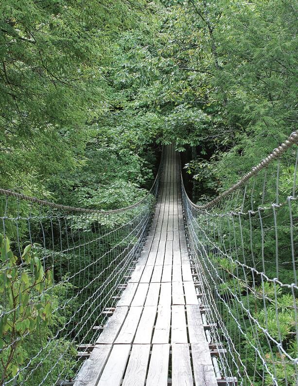
Horsepound Falls in South Cumberland State Now that you have settled in, you can marked and blazed in blue. Horsepound
Recreation Area near Monteagle. Below: The grab a fanny pack with water and food to Falls is a good snack or lunch spot with
Collins River in South Cumberland State Recre- start your hike. The trails are well marked lots of large flat rocks to sit on. If you de-
ation Area near Monteagle.
with white blazes. Although the campsite is cide to go less than a half a mile further,
very easy to reach, the hikes are rated mod- you can see Fall Creek cascade down the
erately strenuous. Some new to hiking may mountain and completely disappear into
Directions want to rest and enjoy the Rocky Point a sinkhole.
Overlook at the campground. Other hikers In order to get back to the Collins
Finding the trail is part of the fun. Take wanting a short hike will choose to go to West Campground, you need to retrace
highway 24 to the Pelham/Winchester exit 127. Suter Falls less than a half-mile from the your hike. You will notice that the hike
Follow highway 50 east toward Altamont for
about 11 miles as you wind up to the top of the campground. The trail leads to a beautiful back is uphill all the way to the camp-
Cumberland Plateau. Make a right turn on high- rock bluff overhang beside the triple drop ground. You will be ready to rest at camp
way 108 South and go about 10 miles to the com- waterfall. The area is a wonderful place to and watch the sunset from the overlook.
munity of Gruetli-Laager. Gruetli and Laager were
two communities settled by the Swiss in the
1860s and the city of Gruetli-Laager was formed
Terry Bonham
in 1980, when the two communities joined to-
gether. You will notice a grocery store just in case
you need some extra goodies for your backpack-
ing trip. You will also notice a dairy bar for an
emergency ice cream stop.
After about another mile, you will see a
brown sign for “Savage Gulf State Natural Area-
Collins Gulf Access” with an arrow pointing to a
left turn onto 55th Avenue. Go straight on 55th Av-
enue for about two miles to the trailhead parking
lot. There is a kiosk with trail maps and a place to
register for your free campsite. As you face the
kiosk, you will see a metal gate to your left at the
entrance to the trail.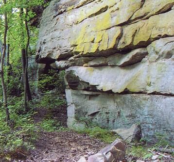
Rock Creek Segment of the Cumberland Trail Offers A Shady Hike for a Hot Day

                                                                                                                                                                                                       Fran Wallas
         he chance to see eagles and the                                     lunch spot, don’t cross the bridge

   T     endangered plant Large-                                               and continue on the Rock Creek

                                                      3
         Flowered Skullcap are                                                   loop. You will climb out of the
   among the attractions of a hike                                               gorge on a series of switchbacks
   along the Rock Creek Segment of                                               with beautiful rock outcrop-
   the Cumberland Trail.                                                        pings. At the top, turn right. A
         The hike begins on a paved                                          short walk brings you to another
   handicapped accessible trail at the                                 sign leading you to the Leggett Point
   parking lot. You will soon come to a sign                         Overlook. This side trail has yellow
   with many hiking options. Choose the                              blazes and ends at the overlook in two-
   hike that works the best for you depend-                          tenths of a mile. You may be lucky
   ing on when you want to eat, whether                              enough to see the rhododendrons in
   you want to play in the creek, or how far                         bloom all along the way. Take time to                                       A scene of Rock Creek, next to the trail. There’s
   you want to hike. The best picnic areas                           enjoy the beauty of this special place. You                                 nothing like cold water on a hot day.
   are the Rock Creek Overlook, the                                  may even see a pair of eagles.
   Leggett Point Overlook, and shady spots                                 When you get back to the main trail,
   beside Rock Creek.                                                turn right, and hike about 1.4 miles to
         For a pleasant six-mile day hike, take                      complete the loop. As you hike back down
   the connector trail to the Rock Creek Loop.                       into the gorge, keep a lookout for an en-

                                                                                                                                                                                                       Fran Wallas
   The trail is marked with white blazes. You                        dangered species of plant called Large-
   can listen to Rock Creek most of the hike. If                     Flowered Skullcap. Contrary to its name,
   you come back in the winter, you can see                          this perennial herb in the mint family has
   the creek most of the hike.                                       very small but elaborate purple flowers.
         The connector trail ends at the loop                        The trail had to be rerouted to protect
   trail in 1.2 miles. The sign says “Cum-                           these plants. When you finish the loop, you
   berland Trail” with arrows pointing to                            should recognize the sign and turn left on
   the right and left. Take the trail to the left                    the connector trail back to the lower
   to continue hiking in Rock Creek gorge.                           Leggett parking lot.
   There are several chances to explore the                                Volunteers built this wonderful trail. If
   creek, cool your feet, and enjoy a scenic                         you would like to help build connecting
   snack. In about a mile, you will come to a                        trails, sign up for the “Big Dig.” You can
   long bridge made out of natural trees. If                         volunteer as much or as little as you would                                 Volunteers Bill Leiper, second from right, and
                                                                                                                                                 Veronica Greear, right, help build the Cumberland
   your stomach is growling at this point,                           like from May 22nd- June 25th. No expe-                                     Trail.
   you may want to go across the bridge to                           rience is necessary. Detailed information is
   take a short detour to Rock Creek Over-                           available on the Cumberland Trail Confer-
   look. If you can wait for an even better                          ence Web site www.cumberlandtrail.org/.

   Below,left: Leggett Point Overlook is a perfect lunch spot. Below,right: Large Flowered-Skullcap blooms in
   May. A population of the flower was protected when land was purchased for the Cumberland Trail.                                                             Directions
                                                       Fran Wallas

                                                                                                                  Division of Natural Heritage

                                                                                                                                                         Directions to the Rock Creek trailhead:
                                                                                                                                                   From Hwy 40 take Hwy 111 South to Hwy 27
                                                                                                                                                   and go east towards Dayton to the town of Sale
                                                                                                                                                   Creek about 6.2 miles to Leggett Road. Turn
                                                                                                                                                   left on Leggett Road, a tiny intersection. (You
                                                                                                                                                   may want to ask for directions to Leggett Road
                                                                                                                                                   at a service station in Sale Creek.) Drive about
                                                                                                                                                   1.6 miles to a paved drive on the left that leads
                                                                                                                                                   to a large paved parking lot. You will see the
                                                                                                                                                   sign for the Rock Creek Segment of the Cum-
                                                                                                                                                   berland Trail.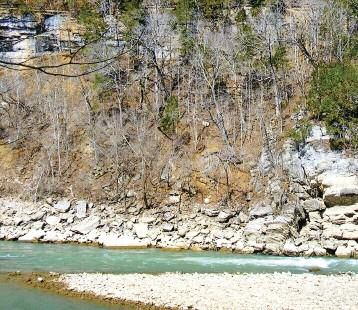
Fa l l C r e e k Fa l l s C a b l e Tr a i l - T h e S h o r t e s t H a rd H i k e
Fran Wallas
he Cable Trail at Fall Creek rock climbing? Now is your chance
T Falls State Park near to find out. At the beginning of
4
Pikeville is a wonderful the trail, you get the feeling of
summer hike. Rhododendrons going over the edge as you hang
shade the whole way. There is on to the cable and begin lower-
no poison ivy, and at the end of ing yourself from rock to rock. It
your hike is the cool stream. is an adventure as you go from one
This trail also offers a chance to side of the cable to the other carefully
see if you are part mountain goat. Have choosing your way down. The hike
you ever wondered if you would like down and back is less than half a mile.
Although this hike is short, you
may want to allow several hours to
Fran Wallas
fully enjoy it.
Once at the bottom, there are
many places to explore. You may
want to choose a rock nearby for
Above: The start of the Cable Trail at Fall Creek that perfect picnic. Take off your
Falls State Park sends you over the edge into shoes and cool your feet in the
the rhododendron. Right: Hiking up the Cable creek. For a special treat, bring a
Trail is a different experience than the hike book, and read to the sound of the
down. waterfall.
If you enjoy rock hopping, try
winding your way down the side
of the stream. Before you wander
downstream, be sure to pile some
rocks or leave a piece of clothing to
help you find the trail when you
Directions return. In late summer, you may
see the trees on the bluff above just
From Nashville take I-40 to exit 288 and
take Highway 111 South until you get to beginning to turn their fall colors.
Spencer. Turn left on Highway 284 East and The hike up is a totally differ-
follow the signs to Fall Creek Falls State Park. ent experience from the hike
From Knoxville, take I-40 to Crossville to exit down. You will get to know the
322 Peavine Road. Take a left off of the exit
and turn right at the light on Highway 101. rocks really well as you look for
Take Highway 101 to Highway 30. Turn right footholds and knobs to grab onto.
on Highway 30. Drive until you get to the en- When you reach the top, you will
trance to the park on the left. Once you have want to take one more look back.
reached the park, follow the signs to the na-
ture center and park in the picnic area. Trail Yes, you really did it.
maps are available at the nature center and at
the inn.
You may want to start off your hike by
walking towards the Nature Center, but taking
A look down to the end of the Cable Trail at Fall Creek Falls State Park.
Fran Wallas
the first walkway to the right. At the end of the
walkway is a beautiful overlook. There is one,
and if you are lucky, two waterfalls depending
on flow. Way down at the bottom beside the
creek, you will see your hike destination. To
get to the trailhead, walk back to Highway 284
and turn left walking past the sign that says,
“to 30. A short way up the road, you will see
the Cable Trail on your left.
Big Ridge State Park - A Haunted Hike For the Halloween Season
                     n Maynardville, a trail in Big                  programs are offered every Friday

                                                                                                            Luke Askins
             I       Ridge State Park offers some-                      and Saturday night in October

                                                          5
                     thing for the Halloween sea-                        except for Halloween. Call the
                  son as it passes a reportedly                           park office for details.
                  haunted area. Ranger-led pro-                               Continue past the cemetery,
                  grams through the month of Oc-                        and a short connector trail will
                  tober feature spooky topics.                       lead you from Ghost House Loop
                       This five mile moderately difficult       to Big Valley Trail, which is blazed in
                  hike begins on the Lake Trail. There are     red. To complete the loop, turn left onto
                  two side trails on this first half-mile      Big Valley, then turn left on Dark Hollow
                  stretch. You will only want to take the      West Trail.
                  steep climb to the Loyston Overlook if            The Dark Hollow West Trail is now
                  the leaves have fallen so that you can get   a path, but used to be a county road. You
                  a view of the lake. Otherwise stay on the    can still see areas of old homesites. Be-
                  main trail to the dam built by the Civil-    fore 1934 when TVA purchased the land,
                                                                                                                          The Norton Cemetery is one of three historic
                  ian Conservation Corps in the late 1930s.    there were 95 houses, two schools and                      cemeteries you pass on a hike on the Lake Trail
                  You may want to stop here to enjoy the       six churches within the park boundary.                     and Ghost House Loop in Big Ridge State Park in
                  view of the lake and the fall colors. Al-    For those who like to backpack, enjoy the                  Maynardville. Below: Trails in Big Ridge State
                  though this was once farmland, the area      backcountry campsite on your right. Two                    Park wind through hardwood forests. If you miss
                  has become a forest of oak and hickory. If   other backcountry campsites are also                       the fall colors, you will get to see the spectacu-
                  you return in the winter, you may see        available, but you need to check on the                    lar views through the winter.
                  Golden and Bald Eagles and migrating         condition of the trails. You can tell your
                  waterfowl.                                   own ghost stories and listen for Hutchin-
                       After you cross the dam, turn to        son’s horses riding down the road.                         3.5 miles to your hike. Settlers used this
                  your right and continue on the Lake               Be sure to bring lots of water be-                    route to take their corn to the Norton
                  Trail. At the junction of the Lake Trail     cause the water source dries up during                     Mill. The trail runs along the top of Big
                  and Ghost House Loop, turn left and          parts of the year. The trail crosses a                     Ridge. There are views in both direc-
                  then bear to your right. The eastern arm     bridge and stays along the edge of the                     tions and wonderful fall colors. There
                  of Ghost House Loop will take you to         lake back to the dam. Turn right, cross                    are also the remains of settlements from
                  Norton Cemetery. You will find the           the dam, and follow the trail back to the                  the 1800s and some very large oak trees.
                  sunken grave of Maston Hutchinson,           parking lot.                                               You need to backtrack to the Dark Hol-
                  who fought in the Civil War. Supposedly           For those who would like to take a                    low West junction.
                  his home was haunted, and people have        longer steeper hike, from the intersection                      For information, call the Big Ridge
                  heard eerie sounds in the area. You may      of Big Valley Trail and Dark Hollow con-                   State Park office at 1-800-471-5305.
                  want to go to a ranger program to hear       tinue up Big Valley Trail all the way to
                  about the strange occurrences. These         Indian Rock. This side trip adds about

                                                                                                                                        Directions
  Geri Reynolds

                                                                                                                                  Directions to the Big Ridge trailhead: take
                                                                                                                            Highway 75 to exit 122. Take Highway 61 east.
                                                                                                                            The brown state park signs will lead you to the
                                                                                                                            park entrance on the left. Follow the signs to
                                                                                                                            the office where you can pick up a trail map.
                                                                                                                            Because of the pine beetle damage, you will
                                                                                                                            need to check at the office about the condition
                                                                                                                            of the trails. The office parking lot is a good
                                                                                                                            place to leave your car for the day. Walk past
                                                                                                                            the ball field to the end of the parking lot and
                                                                                                                            follow the road to the left. You will see the
                                                                                                                            trailhead on your right.
W e t l a n d s , W i l d e r n e s s a n d W i l d l i f e a t B i g H i l l Po n d
                                                                                       t Big Hill Pond State Park in                           decide which way to go or to wait

                                                                                A
Fran Wallas

                                                                                       Pocahontas, you don’t have                                for friends who decide to hike to

                                                                                                                          6
                                                                                       to hike very far from your                                 the tower. The 70-foot tower is
                                                                                car to sense that you are in a                                     well worth a side trip if you want
                                                                                very special place.                                               to get a bird’s eye view of the
                                                                                      This is a park where you can                               whole area. The hike to the dam
                                                                                find solitude and the feel of                                  goes across the levee with scenic
                                                                                wilderness. When you explore the wet-                    views down the length of the lake.
                                                                                lands you may be lucky enough to spot                         After crossing the levee, hike up the
                                                                                an otter, muskrat, or mink. You will also                steep hill to a gate and gravel parking.
                                                                                see migrating birds in the late fall or                  Turn left on the trail that is just behind
                                                                                early winter. The trail begins at the edge               the gate. The trail winds for several miles
                                                                                of the Travis McNatt Lake. Begin the                     through the woods. Follow the blazes
                                                                                hike on the trail to the right. This hike is             until you come to a beautiful bridge.
                                                                                about five miles and is perfect for a short              Cross the bridge and turn left to get back
                                                                                winter day.                                              to the starting point of your hike. Check
                                                                                      The trail follows the lake with scenic             with the ranger and trail map to see how
                                                                                views all along the way and crosses a                    to extend the hike to make a larger loop.
                                                                                short boardwalk area on your left. Fol-                  If you have more time and energy, you
                                                                                low the trail blazes along the other side                will especially want to add the Dismal
                                                                                of the lake until you get to a trail sign                Swamp section to your hike.
                                                                                leading to the Grassy Point shelter. This
                                                                                is a short detour. Depending on the time

                                                                                                                               Fran Wallas
                                                                                of day, you may want to stop here for a
                                                                                snack, lunch, or stay in the shelter for
                                                                                the night. The shelter sleeps six people.
                                                                                      Back track to the trail and turn left.
                                                                                Continue on the trail until you get to an
                                                                                old roadbed/horse trail. There are both
              Beech Trees, like this one along the trail at                     white and red blazes on the trees. Turn
              Big Hill Pond State Park in Pocahontas, are                       left and follow the road until you get to a
              among the last to lose their leaves in fall.                      site with signs that give you several
                                                                                choices. One sign leads to the tower and
                                                                                the other sign leads “Back to Dam.” This
                                                                                is a good place to sit with your friends to

                                                                                                                     Dismal Swamp at Big Hill Pond State Park in Pocahontas.
                                                                                                                        Below: Travis McNatt Lake at Big Hill Pond State Park.
                           Directions
                                                                  Fran Wallas

                     Take Highway 40 to Jackson and follow
               Highway 45 south toward Corinth. Be careful to
               follow all of the Highway 45 twists and turns.
               When you reach the town of Eastview, turn
               right, and go west on Highway 57 about 10
               miles to the entrance of the park.. Drive
               straight on the park entrance road until the
               road ends at the lake. The trail begins at the
               lake edge to your right and left. Trail maps are
               available at the park office.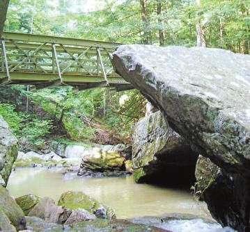
Pickett State Park’s Hidden Passage Trail is a Wonderful Winter Trek
                          hen most of Tennessee has                                   Each time the trail disappears

            W             lost its greenery, in                                   into a rock house, you will follow it

                                                                  7
                          Jamestown, Pickett State                                  until it leaves the rock house on
                Parks’ Hidden Passage Trail is                                      your right. There are two well-
                lined with the green of laurel,                                     marked spur trails for interesting
                huckleberry, teaberry, and rho-                                    short side trips. One goes to dou-
                dodendron.                                                      ble falls and one goes to an old rail-
                      There aren’t enough adjectives to                    road tunnel that is now closed for safety
                describe the beauty of this Civilian Con-                reasons. Because winter days are short and
                servation Corps built 10-mile loop trail                 the trail is long, you may want to save the
                that winds through Pickett State Park                    spur trails for another day.
                and State Forest.                                              About half way around the loop you
                      The trail starts at the Sheltowee Trace            come to the Thompson Overlook. This
                sign. Hidden Passage Trail is the southern               large sandstone bluff is a great place to
                end of the Sheltowee Trace National Recre-               enjoy the views in all directions. It is easy to
                ation Trail that runs 278 miles through                  take a wrong turn at this point. Don’t start
                Kentucky’s Red River Gorge. Follow the                   hiking up the dirt road. The trail stays near

                                                                                                                             George Hatton
                trail until you come to a split. Don’t take              the bluff and reenters the woods. If you do
                the left turn to the group camp. Continue                turn up the road, you will immediately
                straight ahead following the Hidden Pas-                 come to a small wood sign that says, “trail.”
                sage sign and the blazes that are either green           The arrow will point back behind you.                         Along the Hidden Passage Trail at Pickett State Park
                metal diamonds or green rounds with a sil-               Turn around and look for the green dia-                       in Jamestown, Crystal Falls is seen in the snow.
                ver hiker.                                               mond blaze.
                      The first fun stop is a bench built in a                 The trail winds through the woods                      sage sign pointing left. You may think
                sandstone hollow not big enough to be                    and leads to an open area under power                        that you have passed the scenic part of
                called a cave or rock house. You may want                lines. Walk directly across the open grassy                  the trail, but there are still some beautiful
                to keep hiking until you get to the grand                area under the power lines until you get                     rock walls. You even cross a very tiny
                rock houses further along the trail. The                 to the continuation of the trail on the                      natural bridge. The trail dead ends back
                rock houses are great shelters from the                  other side. The trail eventually comes to                    at the sign leading to group camp that
                wind on a cold day. Just at the bench the                a junction with a road and a sign leading                    you saw when you started your hike.
                trail turns right. Further along, you will no-           left to Rock Creek. Instead you will turn                    Turn right and follow the trail back to
                tice a side trail on your right to Crystal Falls.        to your right and follow the gravel road                     the parking lot. Before you reach the car,
                The side trail is short and steep so be careful          past the volleyball net in the group camp.                   you will be planning a return trip in the
                if the rocks are iced over. The falls are beau-          The gravel road ends in a paved road that                    spring to see the wildflowers and the
                tiful anytime of the year so you may want to             goes behind the group camp buildings.                        spur trails that you missed.
                wait for the thaw.                                       Continue until you get to a Hidden Pas-

                This bench built in a sandstone hollow is one of the stops along the Hidden Passage Trail in Pickett State
                Park in Jamestown.                                                                                                                        Directions
  Fran Wallas

                                                                                                                                                    Directions to the Hidden Passage trailhead:
                                                                                                                                             Take I-40 to Crossville exit 317. Follow Highway
                                                                                                                                             127 north for 46 miles. Turn right on HWY 154
                                                                                                                                             and go 12 miles to the park entrance. The park
                                                                                                                                             office has trail maps. Park campgrounds are
                                                                                                                                             open all year. If you want to backpack, you must
                                                                                                                                             get a free permit from the park office. In winter,
                                                                                                                                             this trail is rated moderate because of the cold,
                                                                                                                                             length of trail and possible slippery conditions.
                                                                                                                                             The trailhead is a little north of the park office on
                                                                                                                                             highway 154. You will see the small parking lot
                                                                                                                                             on your right.
Radnor Lake State Natural Area Offers an Easy Hike for People Wild About Wildflowers
any people love to see Rad- You will come to a junction
M nor Lake State Natural with the Ganier Ridge Trail.
8
Area’s spring wildflower Since most of the flowers are at
show in Nashville. If you don’t the lake level, you may want to
mind sharing the hike with oth- save that loop for the winter
ers, you can begin your hike at view. The larkspur are magnifi-
any time. If you want to have some cent in the area beginning just after
quiet time in the woods, you may want the junction. If you are too early or too
to come early in the morning or on a late for the larkspur, you may see Spring
beautiful rainy day. Beauty, Rue Anemone, Hepatica, Tooth-
Begin your hike at the visitor center wort, Wild Geranium, or Trout Lily. The
to get a trail map and learn about the his- lake trail ends at Otter Creek Road in
tory of the natural area. Park rangers can about one and a half miles.
tell you which flowers are blooming and Turn right at the road and hike back
where to find them. The side door of the toward the visitor center. Although you
visitor center leads to the Spillway Trail. won’t see many flowers on this part of
You will forget that you are in the middle the hike, you will pass several wetland
of a city and feel like you are in a wilder- areas. This is your chance to see many
ness. In a quarter of a mile, you will see turtles including sliders, Snapping Tur-
the spillway and lake built in 1914. The tles, soft-shelled turtles and Mud Turtles.
spillway is a good place to watch the If you are really lucky, you will see the
geese, find turtles, or glimpse the shad- otters and muskrat that live in the area.
ows of few big fish. Follow the fairly As you walk down the road, you will
level Lake Trail and you will begin to see pass a trailhead on your left for the South
more flowers and maybe a few deer. You Lake Trail. This trail is more of a climb,
may want to stop at one of the benches to but has trillium, Jack-in-the-Pulpit,
listen to the birds. More than 200 differ- Celandine Poppies as well as more lark-
ent birds have been identified in the area. spur. You may want to take this detour
You can frequently hear the call of a that is only a mile. The South Lake Trail
Barred Owl and can see them even in the climbs the hill and loops back down to
daytime. This is a good hike to be en- the road. In any case, the road leads you
Fran Wallas
joyed slowly. back to the visitor center parking lot and
you are back in the middle of a big city.
Larkspur decorates the trail for spring at
Radnor Lake State Natural Area in Nashville.
Fran Wallas
Below right: These geese were seen on a log
at Radnor Lake State Natural Area in
Nashville.
Directions
Take I 65 to Harding Place, Exit 78. Travel
west on Harding Place (or Battery Lane) to
Granny White Pike. Turn left and travel south to
Otter Creek Road and turn left (across from
Granny White Market). The road ends at the
parking lot.Frozen Head State Natural Area Offers an Overnight Hike With Scenic Detours
aterfalls and over 30 species the richest in botanical diversity.
W of wildflowers blooming When you are ready to continue
9
in May and June are the hike, take the trail back to the
among the highlights of a hike junction, turn left and follow the
on the eight mile loop trail at blue blazes across the bridge. You
Frozen Head State Natural Area begin climbing up Old Mac
in Wartburg. Mountain. Panther Branch runs be-
You can do this hike as a strenuous sides the trail with scenic cascades, drops
day hike, but backpacking gives you more and pools. The trail winds through the
time to enjoy the beautiful detours. If you woods and meets North Old Mac Trail.
David Engebretson
are backpacking, stop at the visitor center to Turn left and follow the red blazes another
fill out a free backcountry permit. Park staff mile to another logging road.
have trail maps and helpful information Just ahead of you, you will see a
about wildlife and wildflowers. sign for the Panther Gap Rock House.
When you leave the visitor center, turn You probably are ready to rest anyway Mountain Laurel in bloom at Frozen Head
right and drive along the park road until it so take a side trip down to this grand State Natural Area in Wartburg.Below,left: A
ends at the trailhead parking lot. The Pan- rock house. If you hiked at a leisurely hiker stops at DeBord Falls in Frozen Head
State Natural Area in Wartburg.
ther Branch trail begins on an old logging rate, the sun is probably starting to go
road. As you follow the blue blazes, you down. Climb back up to the logging
will see over 30 species of wildflowers that road and turn left up Frozen Head When you come to the junction with
bloom in May and June. Surveys have iden- Mountain to the Tubb Springs camp- Judge Branch Trail, don’t turn left. Con-
tified over 144 species of wildflowers in the site. The Civilian Conservation Corps tinue straight, following the yellow blazes.
natural area. There are also waterfalls on built the stone springhouse and fire- The trail ends at another logging road.
both sides of the trail. place at the campsite in the 1930s. Turn right and follow the logging road.
The first detour is to DeBord Falls. Water is available year round but needs There are many tempting trails that cut off
Follow the loop trail to the overlook and to be filtered or treated. It’s a good idea on the right and left. Keep straight on the
then follow the trail down to the waterfall. to hang your pack to keep the mice out. road until you come to a parking lot and
This is one of the best places to have a In the morning, you may want to hike trailhead restroom—a welcome sight. The
snack and cool your feet. to the fire tower. At the time of this article, restroom has a hot shower. Continue to
Further along Panther Branch Trail, the tower is closed for repairs, but the the paved park road and turn right. You
you come to a junction. Keep hiking tower site has good views of the surround- have less than a mile to road hike back to
straight ahead to take the half-mile detour ing area. To return, take the South Old your car.
to Emory Gap Falls. This waterfall is much Mac Trail that is blazed in yellow. The trail- If you enjoyed the hike, you may
steeper than Debord Falls. Leave time to head is just across from the Tubbs Spring want to come back on the third Thurs-
savor this site. There are enough big rocks campsite. You will cross many seeps so be day of each month to help build and
for just the right picnic or resting spot. sure to wear waterproof boots and be care- maintain the trails. You don’t need any
This cove and Panther Branch Cove are ful on the slick rocks. experience or special tools, just a love
for Frozen Head. For information call
423-346-3318.
Fran Wallas
Directions
Directions to Frozen Head: From Harri-
man, take Hwy 27 North to Wartburg. Turn
right on Highway 62. Go two miles and turn left
on Flat Fork Road. In four miles you will be at
the park entrance.B ugg ytop Ca ve –A Cool Hi ke for a Hot Da y
uggytop Trail in the Carter and a hard hat if you have one.
B Natural Area, a 375-acre When your eyes adjust to the
10
natural area located in dark, shine your flashlight at the
Franklin County in South roof of the cave to see it sparkle.
Cumberland State Park, is a The hike is sometimes a crawl
strenuous five-mile hike. through the winding passages
There are some steep ups and and across several wet areas.
downs and an exciting loop through a At the other end of the cave is an-
cave. If you are not an experienced caver, other main entrance called Peter Cave.
you will enjoy taking a ranger led cave After this adventure, you will continue
trip for your first visit. along the loop to a large bluff overlook.
The hike begins with a short steep You are standing above the Buggytop
climb through the woods. The well Cave entrance and you’ll get a view of the
marked trail winds around some interest- whole valley. This is a good time to soak
ing boulders that make good resting up the summer heat that now feels great.
spots. The trail levels, and you begin to Just past the bluff, you will get to the trail
see summer wildflowers. Hike past the junction that leads left to Buggytop Cave.
kiosk that has a map of the trail. Unless you want to take the whole hike
When you get to more open sunny again, you will continue straight ahead,
spots, you may be lucky to find the rare back to the parking lot.
Cumberland Rosinweed in bloom as well
as the Eggert’s Sunflower. Watch for
lizards sunning themselves on the rocks.
In about a mile and a half, the trail splits
and you will take the trail to the right. The
trail takes a steep climb down as it skirts a
rock wall. At the bottom is a cool stream
Fran Wallas
running out of the grand cave entrance
shaped like a buggy top.
This steep downhill trail leads to Buggytop Cave in If you don’t want to go through the
the Carter Natural Area in South Cumberland State cave, you can stop beside the stream.
Park. Right: Cumberland Rosinweed is an endan- This is a great picnic and play spot. You
gered plant you might see as you hike on Buggytop can then return the way you came.
Trail in the Carter Natural Area in South Cumberland
Jason Reynolds
State Park. Below Right: The entrance to South
For the more adventurous, follow
Cumberland State Park’s Buggytop Cave in the the ranger into the cave. You will need
Carter Natural Area. flashlights, sturdy hiking shoes, jacket
Allen Reynolds
Directions
Take exit 134 off I- 24 and turn towards Se-
wanee. Turn left on Highway 56 and go approxi-
mately six miles to the parking area on the left.
Look for the Carter Natural Area sign. Buggytop
Trail begins at the parking lot. Trail maps and the
schedule of ranger led cave trips are available
from the South Cumberland State Park visitor
center in Monteagle. You may want to call the
visitor center at 931-924-2956 to find out more in-
formation on cave trips.Nathan Bedford Forrest State Park – A Colorful Woodland Loop
A
hike at Nathan Bedford For-
rest State Park in Eva is a
high point. Literally. The
park is home to Pilot Knob, the
highest point in West Tennessee,
used in navigation by early river-
boat pilots.
11
The best place to begin a hike at
Nathan Bedford Forrest State Park is at the
visitor center. Park staff members have pre-
pared trail maps that are color coded for the
three, five, 10, and 20 mile hikes. The col-
ors on the map match the blazes on the
trails. The five-mile hike, outlined in or-
Travis Stover
ange, is a perfect introduction to the beau-
ties of the park.
To get to the trailhead, drive through Kentucky Lake, seen from Pilot Knob in Nathan Bedford Forrest State Park.
the park to the end of the road at the Ten- Below left: The five-mile trail in the hollow at Nathan Bedford Forrest State Park.
nessee River Folklife Interpretive Center
parking lot. You will want to spend time at
the folklife center to learn about the history many blueberry bushes on both sides of though roadbeds aren’t as scenic, they are
of the area, see some of the wildlife, and the trail. great if you are with a group. You can
enjoy the views of Kentucky Lake. The The trail descends steeply. You enter enjoy talking with your hiking buddies
center is also a good place to bird watch a shady hollow where Paw Paws thrive. without going single file. The trail goes
since Bald Eagles have been spotted there There are several small creek crossings, over gently rolling terrain and ends at an-
as well as other migratory birds. You will but the water is usually shallow. You soon other roadbed. Turn left and follow the
learn about life on the river and mussel come to the trail junction where the trail until you get to a gate and old cabin.
diving. The center is also a good place to three-mile trail splits off to your left. A Turn left on the roadbed. The trail leads
fill up your water bottles and buy a few little way past this split, the trail begins to you back to the park road. You can take
peppermint sticks. climb up to the top of a large hill. There the road or the trail up to the parking lot.
The trail starts behind the center. Fol- is an overnight shelter and a campsite at You may want to plan your hike so that
low the orange blazes. Since the beginning the top. This site is a good place to have a you can go to the Folklife Festival in Sep-
of the five-mile trail is also the beginning of snack or lunch, but there is no water tember or attend one of the many ranger
the other trails, you will see several differ- available. programs in the park.
ent colored blazes along the way. The first Continue on the trail until you get to For more information, call the
half-mile is along the ridge top with views the next trail junction. The five-mile trail Nathan Bedford Forrest State Park office
of the lake and the fall colors. There are turns to the left on an old roadbed. Al- at 731-584-6356 or visit www.tnstate
parks.com/NBForrest.
Travis Stover
Directions
Directions to Nathan Bedford Forrest
State Park: Take I-40 to Exit 126 and travel
north on Highway 641 for 15 miles to Camden.
Do not take the Highway 70 By-pass. Continue
instead to the traffic light and turn right on
Highway 70 East. Follow the signs to the park.Montgomery Bell State Park – A Six-Mile Overnight Hike For Beginners of All Ages
ontgomery Bell State Park In the morning, continue your
M in Burns was one of hike crossing the stream a few
12
three parks that were more times. Watch the blazes. It is
built as recreation demonstra- easy to miss the second stream
tion areas by the federal govern- crossing.
ment in the 1930s. The trail climbs a steep hill
Before you start your hike, and comes out at a road. Cross the
notice the small building built by the road and follow the trail sign leading you
Works Project Administration in 1936. up the road to your left.
This building was the original park infor- The trail continues on an old log-
mation office. The yellow stone was ging road on your right near a gate. This
quarried on the park. isn’t as confusing as it sounds. Follow the
As you climb the hill at the begin- logging road and the blazes for about half
ning of the hike, you will see that there a mile. There are several dirt roads and
are three shelters and the possibility of an trails leading to your right. Don’t turn on
11-mile loop. Wildcat Shelter is the easi- any of these. You will come to a clearly
est to reach and is only three miles away. marked “M.B. Trail” sign where you
You won’t need to wear yourself out with need to turn off to the right. The trail be-
a heavy pack. You only need food for one comes fairly level and easy to follow.
night, camp stove and matches, warm You will come to a trail junction
sleeping bag and pad, rain gear, water with another large trail sign listing sev-
Fran Wallas
bottle and flashlight. eral possibilities. The shortest route back
The trail climbs to a wooded ridge is 2.7 miles to the parking area. You begin
Hiker Shirley Ora and Rosie at the Wildcat above a creek. The white blazes are easy to see Creech Hollow Lake peeking out
Shelter at Montgomery Bell State Park. to follow as the trail winds along the through the trees. The trail leads to a
Below right: The beginning of Creech Hollow ridge through the hardwood forest. The grassy knoll beside the lake where you
Lake at Montgomery Bell State Park.
trail then drops down and follows a can relax and have a snack. Walk through
stream. There are a few shallow stream the grass along the edge of the lake until
crossings. The Wildcat Shelter is next to you get back to the woods and the reas-
the stream so there is plenty of water to suring blazes.
use as long as you filter or purify it. The Before you get to the end of the hike,
shelter has six bunk platforms built in for you will come out near the park’s visitor
your sleeping bags. Winter nights are a center. The easiest way back to your car is
great time to stargaze. Although Mont- to take the road past the visitor center back
gomery Bell is near a populated area, to the old park office parking lot. If you
Directions there is not much light pollution. You want to hike a little more and are interested
Take I- 40 West to Exit 182 have the sense of being tucked away in in the history of the park, stop by the visi-
(Fairview/Dickson Highway 96). Turn left distant woods. Children will be able to tor center to ask about other short hikes to
(West) onto Highway 96 and take it until it ends experience a bit of wilderness. historic sites in the area.
at Highway 70. Turn right on Highway 70 and
go about three miles. The park entrance is on
Fran Wallas
the right.
As soon as you enter the park you will see
a small building on the left side of the road.
Turn left into the parking lot beside the build-
ing. The Montgomery Bell trailhead is on the
hill next to the parking lot. Trail maps are
available for sale at the park office just down
the road. Overnight hikers must register at the
park office. You can call ahead in order to get
your permit and be sure the shelter is avail-
able. The phone number is 615-797-9051.Three Ways to Hike The Perfect Winter Trail at Long Hunter State Park
his hike at Long Hunter State were deposited when Middle Ten-
T Park in Hermitage is the nessee was a shallow sea. If you
13
best on a winter day. The look carefully, you may find fos-
trail is well marked and easy to sils of marine life. Common fos-
find even in the snow. The sils found in these formations
leaves are gone so you get lots of include brachiopods, bryzoans,
views of J. Percy Priest Lake. Win- gastropods, and occasionally you
ter is a quieter time with fewer motor- may even find parts of a trilobite.
boats and less noise on the lake. In less than a mile you get to the junc-
The trail starts at the parking lot. You tion of the Volunteer Trail and the Day
will want to take a trail map from the box Loop Trail. Turn left on the Day Loop
at the trailhead. If you are a strong hiker Trail. The blazes are now orange and really
trying to speed up your heart rate, you show up on a snowy day. The trail goes
may choose to go to the campground and through some sinkholes that are typical of
back as a 12-mile day hike. If you want to karst topography. At about two miles, you
slow down and spend a few days in this get to a bench right at the lake. This is a
beautiful park, you may choose to do an great spot to watch for migrating birds,
overnight hike. The trail to the camp- read, think, snack, or rest. You will cross
ground is an easy six-mile hike. The some scenic limestone bluffs along the
campsites are tucked beside the lake on a way. The trail begins to curve and follows
wooded hillside. Water is always available, the side of a cove.
but you need to purify it. You have to get In about 2.5 miles, you get to the
April Welch
a free camping permit from the park office junction with the Volunteer Trail. You will
before beginning your hike. The camping see a kiosk and another bench on your left.
The Day Use Trail at Long Hunter State Park in
sites are available on a first come basis. If you are ready to end your hike, you will
Hermitage offers a spot to sit and enjoy na-
To really enjoy the beauty of the area, go right instead. The trail sign says “Trail ture. Below,left: Limestone outcroppings are
you may want to take the four-mile Day Head” with an arrow pointing the way. seen along the Day Loop Trail at Long Hunter
Loop Trail that is part of the longer trail. The trail is now blazed in white since you State Park in Hermitage.
The hike begins as a wide gravel path. have rejoined the Volunteer Trail. Watch
Keep a lookout for the wooden foot- for an old stone wall that goes right across Are you wondering why this trail is
bridge on your right a little further down the path. You will wind through an oak- called the Volunteer Trail? This trail exists
the path. The footbridge is the start of the hickory forest and pass some interesting because scouts, school groups, individu-
Volunteer Trail/Day Loop Trail. Follow rock formations. When you get to the Day als and organizations volunteered many
the white blazes. You are rewarded Loop/Volunteer junction, go straight un- hours to build this trail. If you are inter-
quickly with views of the lake. The dirt less you want to hike the loop all over ested in helping to maintain a park trail,
path leads through and around Ordovi- again. Remember to turn left at the gravel please contact the state park office at 615-
cian limestone outcroppings. These rocks path to return to the parking lot. 885-2422.
Fran Wallas
Directions
Directions to Long Hunter State Park
Trailhead: Take I-40 to the Mount Juliet
Exit/Highway 171. Follow Highway 171 south
toward Long Hunter State Park - almost six
miles - to a small sign for Bakers Grove “Vol-
unteer Trail.” Turn right and go a very short
distance to the end of the road. Turn left and
the road dead ends at the parking lot.T h e L a k e Tr a i l ’s i n B l o o m a t S t a n d i n g S t o n e
pring flowers, historic build- The trail begins a long steady
S ings, and a chance you might climb up to the crest of the hill.
14
see eagles and hawks are There is a great view of the lake
among what draws folks to hike curving below. At the end of the
Standing Stone State Park’s Lake downside of the hill, there is a
Trail in Hilham. picnic table waiting for you. As
To start the hike, cross the you enjoy your lunch or short
road in front of the office. There is a break, look at the Overton Lodge across
sign leading you to the Lake Trail. Hike a the water. You will need to hike along the
few switchbacks below the Park Tea road to the lodge to continue the hike.
Room/Nature Center Building down the After you go around the Overton
Shawn Hughes
steep hill to the road. Walk down the Lodge, walk past the Cooper Mountain
road to the large picnic shelter. The shel- Loop trail going off on the right. Stay
ter is surrounded by blooming redbuds. straight on the Lake Trail that is also
Spring wildflowers, like this Red Trillium, Cross the long suspension bridge over part of the Cooper Mountain Trail. You
can be seen along the trail at Standing Mill Creek. The bridge gives a closer will see both blue and white blazes on
Stone State Park. view of the dam built by the Works the trees. There is a WPA boathouse
Progress Administration in the 1930s. across the water. Follow the trail about
Standing Stone State Park is on the Na- a mile along a branch of the lake until
Shawn Hughes
tional Register of Historic Places because you get to a long footbridge on your
of the WPA projects such as the cabins, left. Cross the bridge and follow the
boathouses, and group lodge. blazes to the next creek crossing that
After crossing the bridge, the trail may require wading. You are entering a
climbs steeply up wooden steps. Follow wildflower haven.
the white blazes and green hiker medals. In about a quarter of a mile, you
The trail flattens out just when you are come to a sign that says “To Overton
ready to stop climbing. In early spring Lodge 2.5 miles; To Dam, 1 mile.”
before the trees leaf out, you will get Since you don’t want to go to either of
scenic views of the dam and picnic shel- those places again, turn right and fol-
ter far below. Any of these overlooks low the trail up the wooden steps to
make a good water and snack break. Ea- another sign. This sign gives you the
gles, Ospreys, Sharp-shinned Hawks, choice of going to the cabin area or to
and Cooper’s Hawks have been spotted the rec hall. You will eventually want to
in the park. Any hikers who are also take the trail toward the rec hall, but
birders will enjoy watching and listen- now is the time to take a detour to-
ing along the way. The trail goes wards the cabins.
A view along the trail at Standing Stone through some dead pine trees that have The highpoint of the hike is the
State Park. been cleared from the path. Although flowered hillside below the cabins. This
these are not pretty, they provide good is the “ooh ah” part of the trail. Depend-
wildlife habitat. ing on when you hike, you may see
When you get to the road, you will Trout Lily, Shooting Stars, trillium, he-
Directions see a representation of the Moses Fisk patica, some leftover Bloodroot, larkspur,
Take I-40 to Exit 288 (The Livingston/ house. Moses Fisk was an early Overton and Twinleaf.
Sparta Exit). Take Highway 111 north to Liv- County educator and founder of Hil- When you have had enough flowers,
ingston. Turn left on Highway 52 west to the
state park sign. Turn left on Highway 136. The
ham, Tenn. The town of Celina is named if there is such a time, turn back and fol-
best place to leave your car is at the park of- after his daughter. The trail begins to de- low the trail towards the rec hall. The
fice. Park staff can give you trail maps and scend through a beech oak forest. As you trail climbs up one last hill and around
flower lists. The 4.8 mile Lake Trail is moder- climb up and down the hills, you will the guardrail at the park road. Turn left
ately strenuous because of the steep changes in
elevation.
cross several seeps that can turn into and follow the road back to your car. You
beautiful waterfalls with enough rain. should reach your car just as your water,
There are patches of Hepatica along the snacks, and energy run out. You may
way. At the next road, turn to your left want to come back another time for a
and go across the bridge. The trail starts ranger-led wildflower hike to find out
again on the right just after the bridge. about the ones you can’t identify.Burgess Falls State Natural Area Offers the Most Waterfalls in the Shortest Distance
n less than two miles, a moder- a quarter mile, you come to the
I ately strenuous hike at Burgess overlook for the first waterfall.
15
Falls in Sparta has flowers, Although this is sometimes
three waterfalls, overlooks and called “Little Falls,” the falls is
scenic limestone bluffs. more than 30 feet high. After
Burgess Falls became a natu- taking a few photographs, con-
ral area in 1973 because of the 130- tinue on to the middle falls. This
foot waterfall and scenic stream. waterfall looks very different from the
As soon as you open your car door, first one. The cascade spans a wide part
Bill Summers
you hear the sound of Falling Water River. of the river and is 70 feet high. As the
The River Trail quickly leads to some cas- water cuts down through the rock, you
cades and a rock overhang. Although the begin a steep climb. The butterfly garden at Burgess Falls State
river is now valued for its scenic beauty, the You soon get to the largest waterfall Natural Area in Sparta has lots of Black-
river was valued in the past as a source of that is shaped like a horseshoe with water Eyed Susans and coneflowers.
power. In the 1920s, there was a gristmill, cascading off of the sides. There is a trail Below,left: Burgess Falls in Sparta.
sawmill, and powerhouse on this site. You almost completed to the base of this falls.
can still see the foundation of the gristmill The trail goes down a metal stairway
and an old pipeline bridge that diverted with 75 steps. Remember that you will put your feet in the water, and enjoy the
water to the powerhouse. have to climb these same steps to get out scenery and a snack.
Cross several beautiful seeps that of the gorge. The spray kicked up from After you climb back to the top,
flow down to the river. There are Foam- the protruding rocks cools you as you climb a little further on a gravel path
flowers, Celandine Poppies, and Dwarf hike down. Once you get to the bottom, turning right onto the Ridge Trail. To
Crested Irises along the way. In less than you can take off your shoes and socks, complete the loop back, follow the Ridge
Trail along the bluff line. There are sce-
nic overlooks of the river far below. The
Fran Wallas
trail curves back to the gravel road. Turn
right and follow the road back to the
parking lot. You may want to get a but-
terfly identification book out of your car
and walk to the butterfly garden. Look
for the Northern Pearly Eye, the Least
Skipper, and the Little Glassywing. You
can rest, warm up, and enjoy the wild-
flowers and the butterflies they attract.
You may even decide that you are rested
enough to take the same hike all over
again.
Directions
Directions to Burgess Falls State Natu-
ral Area Trailhead: Take I- 40 to exit 286. Go
South on Highway 135 for about eight miles.
Follow the signs to the park. The River Trail
begins at the picnic area parking lot.
Brochures on the history and geology of the
area and trail maps are available at the
kiosk.You can also read