Haringey Council Draft Walking and Cycling Action Plan - (Draft for Public Consultation)
←
→
Page content transcription
If your browser does not render page correctly, please read the page content below
Haringey Council

Draft Walking
and Cycling
Action Plan
(Draft for Public Consultation)

2021-2031

                   1
Foreword
The launch of our Walking and Cycling Action Plan (WCAP) comes at an important moment. Its
development has coincided with a dramatic shift in the way lots of us use and look at our local
street networks. Whilst this document was intended to support our bold and ambitious Transport
Strategy and the wider aims of the Borough Plan in providing better infrastructure to support
more walking and cycling, the onset of the Covid-19 pandemic has given a greater urgency to
our action plan and the need not only to increase cycling and walking in Haringey but to ensure
we respond to Covid 19 and the legacy it might create.

We adopted our Transport Strategy in 2018 with the ambition to become a walking and cycling
friendly borough and enabling more journeys in the borough to be made by walking and cycling.
This WCAP will ensure we deliver the Transport Strategy by setting policies and targets, listing
actions, and outlining a monitoring framework to monitor the success of the Action Plan .

The Mayor of London in his 2018 Transport Strategy (MTS) set ambitious targets for the London
boroughs, including 80% of all journeys in the Capital to be made by walking, cycling and public
transport by 2041.The Haringey specific targets are set out in the document. We adopted these
targets as part of the 2019-2022 Local Implementation Plan and this WCAP will help Haringey
achieve these. Achieving these ambitious targets will mean that the council will need to make
choices between space fo pedestrians, new cycle infrastructure and and the reallocating of
roadspace, including rebalancing parking provision, particularly in our town centres and high
streets where space is at a premium.

Since the outbreak of Covid-19, the council’s Transport Strategy and this emerging WCAP have
become important tools for responding to the virus, helping to deliver new pop up cycleways,
pavement widening, and investing in pavement improvements, in town centres, school streets
and developing plans for Low Traffic Neighbourhoods (LTNs) to support active travel and social
distancing whilst the public transport system cannot operate at full capacity.

Our High Streets have been particularly affected by the Covid 19 outbreak and in some cases
are struggling to survive. We intend to do everything we can to support them. The evidence is
clear that adapting our streets to enable more people to walk and cycling makes them cleaner,
healthier and more welcoming which encourages more people to shop locally. This WCAP will
help our High Streets by increasing the uptake of walking and cycling to these areas and
reducing car use which will ensure the future of our High Streets. The economic case for more
cycling and walking to our High Streets is provided in section 3 of this WCAP.

We have worked with Transport for London, the emergency services, our neighbouring
boroughs and other stakeholders to plan a network of safe cycle routes that link parts of the
borough to town centres, schools, our parks and greenspaces and importantly into the wider
London Cycleway network. Near schools we are introducing school streets, in the short term to
provide more space to make socially distanced school walks and cycling possible. The WCAP
will continue to support the council’s recovery, renewal efforts and harness the opportunities
presented from the legacy of Covid 19.

This WCAP is built on a solid foundation and knowledge of our existing network, analysis of it
conducted prior to the Lockdown in early 2020, and the subsequent temporary measures

                                               2
introduced to address the urgent need to provide more space for walking and cycling and
protect residential areas from the potential increase in traffic. Our aim in the short term is to
work with those who have funded our temporary solutions to make those that work permanently
for our residents.

The WCAP schemes form the basis of an emerging high-quality network in Haringey making
walking and cycling natural choices. This improved network will be built upon through the
duration of the lifecycle of this action plan to implement the key improvements needed. A
hierarchy of modes to help deliver Haringey’s sustainable transport future in introduced in this
WCAP. This hierarchy will help the council plan it’s investment and funding. To make streets
safer for walking and cycling in Haringey, the following modal priority is included:

   a)   Pavement users
   b)   Cycling
   c)   Public Transport
   d)   Electric Vehicles
   e)   Motor Vehicles

                                                3
Contents
Section                                                       Page

1. Introduction                                               5

2. Action Plan Policies to support walking and cycling        8

3. The case for Walking and Cycling                           13

4. Walking in Haringey today                                  19

5. Cycling in Haringey today                                  21

6. Barriers                                                   29

7. Walking in Haringey in the future                          39

8. Cycling in Haringey in the future                          44

9. Low Traffic Neighbourhoods                                 55

10. Future: The active school run                             65

11. Future: Active travel and development                     67

12. Monitoring and learning                                   78

13. Appendix A Policy Context                                 80

14. Appendix B Covid-19 Borough-wide Active Travel Response   90

15. Appendix C WCAP Delivery Plan                             97

                                               4
1. Introduction

1.1.   This is our draft Walking and Cycling Action Plan (WCAP) for 2021-2031. It is being
       drafted with input from a team of council officers, councillors, residents and community
       groups with support from cycling, walking and active travel design consultants.

1.2.   This Action Plan sets out how the Council will enable more walking and cycling in the
       borough, in line with the Council’s adopted 2018 Transport Strategy and fulfil our
       ambitions to have a reputation for being a walking and cycling borough both regionally
       and nationally

1.3.   This Action Plan contributes towards social justice and supports businesses in Haringey.
       Enabling more cycling and walking is a social justice issue. as hostile, motor-centric
       streets disproportionately threaten those with the lowest levels of car access. For
       example, children in poor areas who lack gardens play in streets where cultural, legal and
       infrastructural norms leave them vulnerable. Those who contribute least to the problem
       suffer most from its impacts. More walking and cycling to our town centres will create
       better places with less traffic, more people, and cleaner air, and allowing businesses to
       flourish. Making our high streets and public places cycle and walking friendly will make
       them more vibrant, better places to live, to work, to invest in and to raise children in.

1.4.   A key part of this Action Plan is the Delivery Plan which identifies the projects and
       programmes Haringey will deliver through the life of the Plan. The WCAP Delivery Plan,
       attached to this Plan as Appendix C, provides a costed road map to meeting the aims of
       the Action Plan and outlines: the future cycling routes, Low Traffic Neighbourhoods,
       walking schemes, the School Streets programme, the council’s behavioural change
       programme and delivering cycle parking.

1.5.   Vision

1.6.   The vision for this Walking and Cycling Action Plan (WCAP) is simple: by 2031 we want:

   •    a reputation for being one of the best walking and cycling boroughs, both regionally and
        nationally
   •    walking and cycling are natural choices
   •    active travel to have improved the wellbeing of our residents, reducing obesity and
        improving air quality
   •    to reduce motor vehicles use for short trips with a shift to active travel
1.7.   This action plan outlines how we will get there. Our aims and objections are as follows:

1.8.   People Walking

   •    Haringey will have high quality local walking routes

                                                5
•   The borough will be easy to get around on foot, including improved signage and
       wayfinding

   •   Walking will be the natural choice for short trips in the borough

   •   People walking will be the focus of our town centres and shopping areas

   •   Footways will be of a high standard with even surfaces and free of street clutter

   •   Streets in the borough’s shopping centres will be nice places to walk and spend time

   •   Main roads will be easy to walk along and safe to cross

   •   Street lighting will be of high quality throughout the Borough

   •   There will be places to rest, shade, biodiversity and things to look at

   •   Our streets, town centres and places of interest will be accessible by all

1.9.   People Cycling

   •   Our cycle routes and facilities will be among the best in London

   •   We will have an extensive network of attractive and safe cycling routes covering all parts
       of the borough

   •   There will be high levels of cycling amongst residents from all backgrounds and
       communities in Haringey

   •   Cycling will be considered a safe form of transport for everyday journeys for people of all
       ages and abilities

   •   Every household in the borough will be able to access secure cycle parking facilities

   •   High quality cycle parking will be easy to find near to shops and town centres and other
       important locations

   •   Cycle training will be available for everyone who lives in Haringey who wants to learn

   •   Our streets, town centres and places of interest will be accessible by all

   •   Wayfinding and signage will make it easy to cycle in Haringey

1.10. Healthy Streets

1.11. The Healthy Streets approach is the underlying framework for the Mayor of London’s
      Transport Strategy (MTS). This approach is a system of policies and strategies to put
      people, and their health, at the heart of decision making. Haringey has adopted the
      Healthy Streets approach to deliver this Action Plan and the improvements necessary to
      enable the borough to improve people’s experience of walking, cycling and using public
      transport and also encourage fewer trips by car.

                                                6
1.12. Healthy Streets can provide high-quality environments with enough space for walking,
      cycling and public transport use. Streets can be enhanced with seating, shade, trees and
      greenery, and reduced dominance of vehicles by designing for slower vehicle speeds.
      They can hold events and activities that entice people out to shop, play and socialise.
      Adopting the healthy streets approach will help Haringey work towards creating a
      healthier and more attractive street environment, increasing the number of people
      walking, cycling and using public transport and changing streets so that quality of life for
      all people is improved, enabling people to live well and also to reduce inequalities.

1.13. The Healthy Streets approach is not a quick fix to deliver change, it is a long-term plan for
      improving people’s experiences of streets, helping everyone to be more active and enjoy
      the health benefits of an improved environment.

1.14. Figure 1 shows the ten indicators that are used to measure Healthy Streets. Using these
      evidence based indicators will help to ensure that streets are made to be more attractive
      places.

                                                7
1.15. Healthy High Streets

1.16. In 2018 Public Health England adapted the Healthy Streets approach1 for the context of
      High Streets. According to their report, good quality design and furniture in local high
      streets that provide accessible, safe, communal spaces foster social interaction and
      strong local economies and can be used to create healthier, safer and more cohesive
      local communities. This distinction between Healthy Streets and Healthy High Streets is
      supported by the WCAP which recognises the position High Streets play within
      communities and the important role they have in influencing the health of local
      communities and local economy.

1.17. According to Pubic Health England, High Streets should:

           •     be inclusive of people from all walks of life
           •     be easy to navigate, including crossings
           •     provide shade, shelter and places to stop and rest
           •     be walkable and provide options for cycling
           •     have low levels of noise and air pollution
           •     provide things to see and do
           •     have a health-promoting retail offer
           •     ensure people feel relaxed and safe
           •     consider the local context of the high street, its features and current use, and how
                 all these factors interact with one another

1.18. Haringey’s targets for Walking and Cycling

1.19. The MTS sets the following targets for Haringey:

         •     Mode share - 88 per cent of all trips in London to be made on foot, by cycle or using
               public transport by 2041 (77% in 2019)
         •     By 2041 81% of Haringey residents will live within 400m of the strategic cycle network
               (currently 17%)
         •     Physical activity - all Londoners to do at least the 20 minutes of active travel they
               need to stay healthy each day by 2041 (currently 32%)

1.20. As part of Haringey Local Implementation Plan 3 (2019/20 - 2021/22), Haringey adopted
      these targets. In addition, Haringey adopted a Vision Zero approach towards eliminating
      all road traffic deaths and serious injuries by 2041.
1.21. Of the 77% of trips by foot, cycle or public transport in 2019 mentioned above, cycling
      accounts for 3% of all trips in the borough whilst car (and motorcycle) accounts for 23% of
      all trips. Walking accounts for 36% and public transport for 38% of all trips in the borough.

1.22. Currently 17% of Haringey residents live within 400m of the strategic cycle network and
      32% of the borough’s population travel actively for at least 2 x 10 mins a day. Both these
      statistics show the scale of ambition needed in this WCAP to deliver the above targets.

1
    https://www.gov.uk/government/publications/healthy-high-streets-good-place-making-in-an-urban-setting
                                                       8
2. Action Plan Policies to support walking and cycling

2.1.    Policy 1 – Increasing Active Travel

   a) Haringey will be a borough where walking and cycling will be the default choice of travel,
      by improving street environments, supporting accessible and inclusive streets and
      making it easier for everyone to get around on foot and bicycle, and promoting the
      benefits of active travel.

   b) Haringey will reduce dependency on cars in the borough in favour of active, efficient,
      and sustainable modes of travel through the provision of high-quality walking and cycling
      infrastructure.

   c) Haringey will use the Healthy Streets approach to put health at the heart of decision
      making and deliver coordinated transport and street improvements including Low Traffic
      Neighbourhoods, Liveable Neighbourhoods, new cycleways and footway improvements
      to enable more active travel.

   d) Haringey will develop proposals to promote accessible, safer, and well-planned active
      travel opportunities to establish itself as one of the most cycling and pedestrian friendly
      boroughs in London.

   e) Haringey will seek funding to deliver a range of behavioural change programmes to
      enable people to walk and cycle more in the borough, promote social inclusion.

   f)   Haringey will support active travel by reducing road user casualties, especially among
        younger and older pedestrians, cyclists and other vulnerable road users and to address
        the needs of mobility impaired users of all transport modes.

   g) Haringey will ensure all active travel improvements improve the health and wellbeing of
      everyone and tackls the issues of social injustice and social inclusion by making sure
      everyone has access to safe and sustainable transport choices.

   h) Haringey will address barriers to active travel through working in partnership with TfL,
      neighbouring boroughs, emergency services, transport operators, infrastructure
      providers, business, community, and other stakeholders, and the public to deliver this
      action plan.

                                               9
2.2.   Policy 2 – Walking

   a) Haringey will unlock the walking potential in the borough by removing barriers enabling
      more people to travel part or all of their journey on foot, improve the experience of
      walking in Haringey and reduce car dependency by encouraging mode shift from the car
      to walking.

   b) Haringey will create opportunities for new walking trips, particularly to, from and in town
      centres and improve walking access to transport interchanges, schools, parks and other
      destinations.

   c) Haringey will reduce the impact of vehicle traffic and parking, making our streets better
      and safer places to walk and spend time. Trips to school will be targeted through the
      introduction of school streets to reduce car use and promote walking.

   d) Haringey’s streets will be improved for walking using TfL’s Planning for Walking Toolkit to
      ensure our streets remove any disabling barriers for disabled people

2.3.   Policy 3 – Cycling

   a) Haringey will deliver improvements in cycle infrastructure to support more cycling in the
      borough to:
         a. create a cycling culture
         b. improve the health and wellbeing of residents
         c. address congestion and air quality issues
         d. ensure nobody is excluded from the benefits of cycling
         e. reduce the reliance on the car
         f. benefit businesses and help restore vitality to local high streets and town centres

   b) Haringey will address the barriers to cycling to ensure everyone who wants to cycle for
      their journeys will be able to.

   c) Haringey will create opportunities for growing and improving our cycle network to ensure
      our streets work better for people by reducing the dominance of the car.
      Haringey will deliver high quality cycling routes, more cycle parking and cycling training.

   d) Haringey will design cycle friendly streets and spaces which, as a minimum, meet the
      London Cycling Design Standards and the new national cycling infrastructure design
      standards, including the requirement to deliver streets which are coherent, direct, safe,
      comfortable and attractive.

                                               10
2.4. Policy 4 - Low Traffic Neighbourhoods
a) Haringey will deliver a network of Low Traffic Neighbourhoods across the borough to:
a) significantly reduce traffic volumes not only on the residential streets but across
the borough
b) achieve traffic evaporation with short trips previously undertaken by cars being
switched to other sustainable modes
c) increase physical activity through more walking and cycling
d) provide healthy and safer routes to schools and other destinations
e) benefit local businesses
f) create new public space
g) deliver improved air quality
b) Haringey will develop a borough wide vision for Low Traffic Neighbourhoods, taking into
account the function of the street network, the availability of through routes and the
location of key destinations in the borough
c) Haringey will prioritise Low Traffic Neighbourhoods based on where the approach will
have the greatest impact, rather than where it will be easiest. This criteria-based
approach will include the following considerations:
a. Traffic and road danger reduction
a. Potential for more walking and cycling
b. Reduction in traffic volumes and vehicle speeds including mitigating against the
displacement of traffic onto other local roads
c. Enabling social distancing and space to meet
d. Cycle connectivity
e. Safe access to schools and local businesses
f. Demographics/deprivation
g. Deliverability
h. CostCommunity group engagement
i. General suitability/other characteristics
d) Haringey will work with local communities and groups to establish a network of initiatives
to assist in the delivery of Low Traffic Neighbourhoods.
e) Haringey will work with the Emergency Services to ensure the Low Traffic
Neighbourhoods are designed to minimise the disruption to access by emergency
service vehicles.
f) Haringey will ensure the LTNs benefit everyone, not just those living the LTN areas.
112.5. Policy 5 – Re-allocating road space to enable sustainable growth and to make
walking and cycling safer
a) To provide for future demand and to facilitate sustainable transport Haringey will re-
allocate road space to make streets safer for walking and cycling according to the
following modal priority:
a. Pavement users
b. Cycling
c. Public Transport
d. Electric Vehicles
e. Motor Vehicles
b) Haringey will ensure decisions made on re-allocating road space will take into
account the competing needs of streets and their users, particularly in our town
centres, recognising a street functions as both a link and a place.
c) Haringey will where appropriate reallocate existing car parking and loading for high
streets, town centres, schools and other locations, to:
a. Enable more cycling and walking
b. Improve public transport accessibility
c. Facilitate access for freight and servicing including by cargo bike
d. Support the viability of the town centres
e. Make the existing road space more efficient
d) Haringey will seek to re-provide the reallocated car parking spaces from the locations
listed in (c) onto adjacent streets where there is existing parking capacity to
accommodate them. This approach does not prejudice the parking concessions for
people with serious walking disabilities which are set out in the council’s Disabled
Parking Place Policy2.
2
https://www.haringey.gov.uk/parking-roads-and-travel/parking/dedicated-disabled-parking-bay
123. The Case for walking and cycling
3.1. The Economic Case (including supporting our Town Centres and High Streets)
3.2. Our dependence on the car imposes significant economic costs on society. These
include: congestion; road casualties; physical inactivity and the ill health caused by it (e.g.
obesity); pollution (and the associated damage to buildings, ecosystems, agriculture and
health); as well as the geopolitical costs of maintaining fossil fuel supplies in an
increasingly unstable global environment.
3.3. Cycling could substantially reduce these risks, while strengthening the local economy;
supporting a local community wealth building approach, supporting local businesses and
property values; boosting the economic productivity of a healthy and satisfied workforce;
and enabling disadvantaged groups to gain skills and access employment opportunities.
Walking and cycling will support the borough’s Good Economy Recovery Plan in
response to Covid-19 to connect people to new job opportunities and support our high
streets.
3.4. According to Cycling UK3
• If cycle use increases from less than 2% of all journeys (current national levels) to 10%
by 2025 and 25% by 2050, the cumulative benefits would be worth £248bn between
2015 and 2050 for England - yielding annual benefits in 2050 worth £42bn in today’s
money.
• In 2009, production losses due to mortality and morbidity associated with CVD (cardio
vascular disease) cost the UK over £6bn, with around 21% of this due to death and 13%
due to illness in those of working age. Physical activities like cycling help combat CVD.
• Occasional, regular and frequent cyclists contributed a ‘gross cycling product’ of c£3bn
to the British economy in 2010. Around 3.6 million cycles (‘units’) are sold in GB each
year.
• The average economic benefit-to-cost ratio of investing in cycling & walking schemes is
13:1
• Academics who studied the cost benefit analysis used by Copenhagen to decide
whether to build new cycling infrastructure, concluded that cars cost society and private
individuals six times more than cycling.
• On average, cycle commuting employees take one less sick day per annum than non-
cyclists and save the UK economy almost £83m.
• Although cyclists may spend less than car-borne shoppers per trip, their total
expenditure is on average greater because they tend to visit the shops more often.
• On 9th Avenue (Manhattan), where a high quality cycle lane was rebuilt in late 2008,
retail sales increased by up to 49%, compared to 3% borough-wide.
3.5. In June 2016, Arup published a report titled ‘Cities Alive. Towards a walking world’ 4.
3
www.cyclinguk.org/campaigning/views-and-briefings/cycling-and-economy
13Their report found that walkable environments are not just healthier but also wealthier.
The research showed a positive correlations between improved walkability, raised local
retail spend, enhanced value of local services and goods and the creation of more job
opportunities. Their report references research commissioned by Living Streets which
showed that making places better for walking can boost footfall and trading by up to 40%.
Using sales tax receipts to compare retail activity before and after street redesigns, New
York City’s Department of Transportation has recently proved that transforming an
underused parking area in a pedestrian plaza in Brooklyn has led to a dramatic increase
of 172% in retail sales5. The Arup report also reminds the reader that walking is a free
mode of transport and creating more walkable environments, together with investment in
public transport, can reduce congestion costs and provide long-term transport solutions.
3.6. Good design and the reallocation of road space can help bring high streets to life;
creating better places with less traffic, more people, and cleaner air, and allowing
businesses to flourish. Making our high streets and public places cycle-friendly will make
them more vibrant, better places to live, to work, to invest in and to raise children in.
3.7. There is evidence from across London and the UK of the boost in economic performance
and retail vitality that people-friendly high streets can benefit from.
• People who access shops by walking or cycling tend to make more trips to the high
street, which can lead to higher monthly spends than those who access shops by
car.6 They also tend to shop more locally, which supports local businesses and
boosts the local area.7
• Improvements to public spaces have been shown to boost footfall by up to 40%.8
• High street walking and cycling projects have been shown to increase retail sales by
up to 30%.9
• Cycle parking can deliver up to 5 times higher retail spend per square metre than the
same area of car parking.10
• Cycle freight can be cheaper and faster for making deliveries in an urban area. It is
estimated that businesses can save between 39% and 64% on the cost of making
short deliveries compared to the cost of using a van.11
4
https://www.arup.com/perspectives/publications/research/section/cities-alive-towards-a-walking-world
5
https://www.livingstreets.org.uk/policy-and-resources/our-policy/high-streets
6
Cycling and the economy, Cycling UK, 2016 http://www.cyclinguk.org/campaigning/views-and-briefings/cycling-
and-economy
7
The Mayor’s Vision for Cycling in London, GLA, 2013 https://www.london.gov.uk/file/1994
8
The pedestrian pound: the business case for better streets and places, Living Streets, 2014
https://www.livingstreets.org.uk/media/1391/pedestrianpound_fullreport_web.pdf
9
The pedestrian pound: the business case for better streets and places, Living Streets, 2014
https://www.livingstreets.org.uk/media/1391/pedestrianpound_fullreport_web.pdf
10
The value of cycling: rapid evidence review of the economic benefits of cycling, Department for Transport, 2016
https://www.gov.uk/government/publications/the-value-of-cycling-rapid-evidence-review-of-the-economic-
benefits-of-cycling
11
The value of cycling: rapid evidence review of the economic benefits of cycling, Department for Transport, 2016
https://www.gov.uk/government/publications/the-value-of-cycling-rapid-evidence-review-of-the-economic-
benefits-of-cycling
14• There is little evidence of a link between increased car parking and greater
commercial success in town centres in London. Instead, a good mix of shops and a
quality environment are cited as the most important factors in attracting people to
town centres.12
• International evidence shows that replacing on-street parking with cycle lanes has
little to no impact on local businesses, largely due to businesses overestimating how
many of their customers arrived by car. In many cases, there was a positive impact
on local businesses.13
3.8. Inactivity– Health and well being
3.9. Haringey, like the rest of the UK, is in the midst of an inactivity crisis. Changes to how we
work, how we travel, and other social changes have designed physical activity out of our
lives. We need to build physical activity back into our daily lives and routine. Enabling
more journeys to be made in Haringey by walking and cycling will achieve this. It will also
support the borough’s health recovery from Covid-19 through, for example, improved air
quality to support better respiratory health.
3.10. Haringey has a young, ethnically diverse population. The total resident population in
Haringey is 271,22214. Our population is expected to increase by 5% by 2030, to 284,989,
with the largest percentage growth in older age groups (65+). The borough is also the 4th
most deprived borough in London, with deprivation more concentrated in the north east.
3.11. Health and wellbeing in Haringey:
• Over 1 in 5 adults (21.9%) are inactive and do less than 30 minutes exercise a day
• Healthy life expectancy is 65 years for men and 64.5 for women. Healthy life
expectancy reduces by 15 years for women and 17 years for men living in our most
deprived areas compared to those living in the most affluent parts of the borough.
• Almost 1 in 2 adults are overweight or obese (49.9%). In addition to this, over 1 in 5
children (22%) aged 4-5 and over 1 in 3 children aged 10-11 are obese or
overweight (36.7%).
• 1 in 5 adults in Haringey have high blood pressure and a third of our residents are
not getting enough physical exercise
• Around 19,900 people in Haringey or 7.7% of the GP registered population, are
diagnosed with depression, not significantly different to the London average
3.12. In 2019, Haringey adopted its ‘Active Together’ – A Physical Activity and Sport Strategy’,
the vision of which was to create and embed a culture of activity so that Haringey
becomes one of the most physically active and healthy London boroughs. According to
12
The relevance of parking in the success of urban centres, British Parking Association, 2012
http://www.londoncouncils.gov.uk/services/parking-services/parking-and-traffic/parking-information-
professionals/review-relevance
13
The complete business case for bike lanes, CityLab, 2015 http://www.citylab.com/cityfixer/2015/03/the-
complete-business-case-for-converting-street-parking-into-bike-lanes/387595/
14
www.haringey.gov.uk/local-democracy/about-council/state-of-the-borough
15the Strategy, physical activity can contribute towards a wide range of socio-economic
outcomes. The health and well-being benefits associated with being physically active are:
• Reducing the risk of coronary heart disease and stroke by 35%.
• Reducing the risk of developing diabetes and colon cancer by 50% and breast
cancer by 20%.
• Reducing the risk of an early death by 30%.
• Tackling obesity and maintaining a healthy weight.
• Reducing the risk of developing depression, dementia, stress, and anxiety by 30%.
• Reducing loneliness and social isolation.
• Improving mobility and balance, reducing the risk of osteoarthritis by 83% and falls
by 30%.
• Enhancing confidence, self-efficacy, transferable skills and employment
opportunities.
• Offering effective diversionary activities for young people vulnerable to risky
behaviours
3.13. Haringey’s Health and Wellbeing Strategy 2020 lists the proportion of journeys made
through walking and cycling as a key outcome of the strategy. The physical features of a
place influence the health of residents in many ways. Air quality, communal facilities,
good quality housing and green spaces all contribute to healthy, connected communities
and prevention of mental and physical long-term conditions. The strategy’s vision for
Haringey is that it will be a clean, green and safe borough where people of all ages want
to live, work and play, now and in the future.
3.14. Designing and planning future major public developments in Haringey to maximise health
and wellbeing of residents – including promoting active travel and social connectedness
is a priority of the strategy which can be delivered through this WCAP.
3.15. Air Quality and Climate Change
3.16. Transport is the third largest source of emissions in the borough. Whilst low carbon forms
of motorised transport do exist, there are still air quality issues associated with these
solutions (e.g. tyre wear and braking).
3.17. Air quality is the measure of how clean our air is or how much pollution there is in the air
we breathe. The link between travel choices and air quality is direct. Motorised road
transport accounts for about half of the particulate matter and nitrogen dioxide which are
two of the main sources of air pollution attributed in cities.
3.18. In response to clear scientific evidence and consensus on climate change, and rising
public concerns, Haringey Council declared a Climate Emergency in March 2019, being
one of the first London Councils to do so.
163.19. Walking and cycling can bring large improvements in air quality and help deliver the
actions necessary to meet our climate change challenge. Modal shift away from
motorised transport will reduce greenhouse gas emissions from transport and reduce our
overall carbon footprint contributing to extreme weather events, loss of life around the
world, and dangerously high levels of CO2 concentrations. Active travel will support a
green recovery in the borough from the Covid-19 crisis.
3.20. Social Justice
3.21. Enabling more cycling and walking and tackling the use of the private car are social
justice issues. As mentioned above, transport is third largest source of emissions in the
borough yet only 40%15 of Haringey households have a car and this figure is falling. Car
ownership is particularly low in parts of the borough where deprivation is more
concentrated. The council is also aware that most of the vehicle traffic in the borough has
neither started its journey in Haringey nor is it destined for Haringey. Transport poverty is
a reality for many residents in Haringey on lower incomes who struggle with the cost of
car ownership and public transport and therefore take active travel modes as part of the
daily routines and need these modes to be safe.
3.22. Inequalities also exist by gender, age, ethnicity, disability and other protected
characteristic groups identified in the Equality Act 2010.
3.23. Research16 by CyclingUK found that men do nearly three times as many cycling journeys
as women, and travel more than four times as far. TfL’s 2016 Attitudes to Cycle report17
found that ‘regular cyclists are more likely to be men, white, working and non-disabled –
20% of men report being ‘regular’ cyclists compared with 8% of women’. A research
report by Sustrans titled ‘Women, reducing the gender gap’18 found that most women
don’t feel safe and are hesitant to start cycling, Women reported that they feel intimidated
on the roads.
3.24. Disabled people face significant barriers to walking and cycling. The most common
physical barrier to walking is crossing the road. Having enough time to cross, not finding a
safe place to cross the road, signalised crossings that do not work, are all barriers.
Obstructions, advertising boards, wheelie bins and parked cars, are commonly
encountered and make walking difficult. The most common barriers to cycling among
disabled people are lack of appropriate equipment, low availability of safe cycling
infrastructure and lack of confidence and support.
3.25. The Mayor of London’s ‘Vision for Cycling’ 201319 revealed that similar numbers of people
15
https://tfl.gov.uk/corporate/publications-and-reports/travel-in-london-reports
16
https://www.cyclinguk.org/article/campaigns-guide/women-cycling
17
https://tfl.gov.uk/corporate/publications-and-reports/cycling-and-walking
18
https://www.sustrans.org.uk/our-blog/opinion/2019/january/how-can-we-challenge-the-cycling-gender-gap
19
www.london.gov.uk/what-we-do/transport/cycling-and-walking/mayors-vision-cycling
17from white, black and mixed ethnic groups cycle regularly, whilst people from an Asian
background cycle less. People of Black and Asian ethnicity are more likely to never cycle
at all compared to all other ethnic groups.
3.26. This WCAP is needed to enable those who don’t have a car to have a safe travel choice
and at the same time advance equality of opportunity by addressing the barriers faced by
all. The WCAP will deliver safer and healthier streets, improved health from being
enabled to take up active travel options and from improved air quality which will benefit all
residents in Haringey.
184. Walking in Haringey today
4.1. Walking is, in many ways, the mode of travel that is most important to the aims of this
Action Plan. It makes efficient use of street space. It is good for individuals’ health. It
produces no emissions or noise. It is safe and encourages interaction, which improves
lives. It is good for business.
4.2. Walking for leisure is also an important part of living in Haringey for many. We have many
excellent green and open spaces located throughout the borough and in the areas around
us. These walking assets include Parkland Walk, Railway Fields, Tottenham Marshes,
canals and parks. These spaces are popular places for people to walk and also provide
vital green steppingstones between our town centres.
4.3. Walking Potential + Air Quality
4.4. The London Travel Demand Surveys (LTDS) outputs summarise walking potential based
on existing travel behaviours. The survey identifies trip stages that could be reasonably
walked or cycled but are currently made in private vehicles. The LTDS collects travel
pattern data from c.17,000 persons a year and includes details of all trips undertaken on
the day before the interview. Trips and stages made by car, public transport and other
modes from 2014/15 to 2016/17 are included in the dataset.
4.5. The plan highlights hexagons (‘hexs’) within Haringey that have the highest levels of
walking potential. The results suggest significant potential for increased walking in several
clusters within Haringey, including: A1010 corridor between Bruce Grove and White Hart
Lane, Muswell Hill, Crouch End, and Wood Green. To help contextualise current
conditions for walking in the areas with highest potential, the plan also includes walking
collision data and NO2 concentrations. These additional layers of analysis help to focus
on areas which are in most need of support in developing improved walking networks.
194.6. Walking for leisure
4.7. Walking for leisure in Haringey is a popular pastime and one we would like to enable
more people to enjoy. Working with partners we have developed guidance20 and
information on walks inside and out of the borough. This includes walks that follow the
Moselle River by Haringey Friends of Parks forum, a cafe trail, Parkland Walk between
Highgate and Finsbury Park and our Walk in the Park guide. The guide, produced with
partners includes a series of orbital and linear walks through our boroughs’ greenspaces,
open spaces and historical places.
20
https://www.haringey.gov.uk/parking-roads-and-travel/travel/walking
205. Cycling in Haringey today
5.1. Cycling is a popular way to get around in Haringey and becoming increasingly so in
recent years. Over the past 10 to 15 years, there has been a significant increase in the
number of cycletrips and cycling modal share in London; there has been a 130% increase
in cycling trips in London since 200021. This has also translated into more cycle trips and
increased modal shift in Haringey.
5.2. There are lots of places to cycle in Haringey and many more destinations outside the
borough that are easily within cycling distance, including the majority of central London.
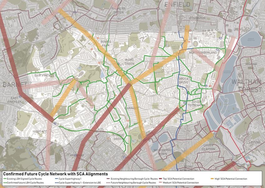
5.3. Existing network
5.4. The existing cycle network in Haringey consists primarily of painted cycle lanes marked
on major roads and residential streets. The network does however include Cycle
Superhighway 1 (CS1), part of Transport for London’s Cycleway network which links the
east of the borough with the city via Hackney.
21
Travel in London Report 9 published by TfL in 2016
215.5. The plan aove summarises the Borough’s existing cycle network and also identifies cycle
routes in neighbouring boroughs. The network is largely comprised of routes using quieter
residential streets and open spaces, and most of these routes are signposted as part of
the London Cycle Network (LCN). The Borough’s two key strategic cycle routes are Cycle
Superhighway 1 (CS1) and National Cycle Network (NCN) Route 1. The list below
summarises key cycle routes within the Borough including NCN Route 1 and CS1:
• LCN 6: Barnet – Alexandra Palace – Hornsey – Camden – West End (Total Length =
19km)
• LCN 7: Elephant & Castle – City – Finsbury Park – Wood Green – Southgate (Total
Length = 14km)
• LCN 10: City – Tottenham – Enfield – Cheshunt (superseded by CS1 in sections) (Total
Length = 17km)
• LCN 54: Alexandra Palace – Wood Green – Tottenham – Walthamstow (Total Length =
18 km)
• LCN 56: Wood Green – Northumberland Park (Total Length = 5km)
• National Cycle Network 1 (NCN 1) – Dover – London – Harlow - Colchester (Total
Length = 396km)
• Cycle Superhighway 1 (CS1) – City – Hackney – Stamford Hill – Seven Sisters -
Tottenham
225.6. In addition, the borough also has a number of routes through areas of greenspace that
provide traffic free alternatives on some routes mainly during daylight hours.
5.7. Connections into neighbouring boroughs include CS1 into Hackney and the newly
constructed segregated cycle tracks at Ferry Lane.
5.8. Focus on Cycle Superhighway (CS1)
5.9. CS1 links the heart of Tottenham via the south of the borough, into Hackney and the city
of London. CS1 is Haringey’s flagship cycle route. It is a combination of two-way cycle
track located on wide footways and sections of on road cycling on residential streets.
Unfortunately the traffic conditions on these sections are hostile and deter most cyclists
from using the route.
5.10. Prior to the Covid-19 pandemic we conducted a review of CS1 as part of the development
of this WCAP. This review has helped inform the WCAP proposals and has been used as
the basis of a proposal for improvements from the Covid-19 initiated Streetspace for
London programme.
5.11. Gaps in the cycle network
5.12. The Mesh Density Analysis was used to evaluate the distribution of the Borough’s current
cycle network using a 400m x 400m grid. The Mesh Density Analysis is included in the
London Cycle Design Standards (2015) and is used to review the density of cycle
networks – the standards recommend that cyclists should not have to travel further than
400m to reach a high quality route. The analysis does not consider the quality of the
existing facilities and should be used to understand areas within Haringey where there
are currently no facilities.
235.13. The plan summarises the results from the analysis and highlights cells within the Borough
where there are currently no cycle routes or facilities. The analysis identifies gaps in the
Borough including four larger areas where there is not a cycle route within 800m:
Harringay and St. Ann’s, Crouch End, White Hart Lane, and Alexandra. Within these gaps
there are also key corridors which have no cycle route or facilities. These include parts of
Seven Sisters Road, Tottenahm High Road and Archway Road.
5.14. Cycling for leisure
5.15. Cycling is a popular pastime in the borough as well as being a popular mode of transport.
Whilst cycling for leisure often involves a ride through greenspace or quieter streets the
conditions need to be right on these routes in the same way they need to be on a busy
commuter route.
5.16. We have worked to include access to greenspace in our analysis of the borough as part
of the development of this WCAP and have ensured the green grid, our developing plans
24for a network of walking and cycling routes into areas of greenspace, is included in the
network developed
5.17. Cycle parking
5.18. Having a safe place to leave your bike is an essential part of the cycling journey and is
just as important as having a safe route. Without the correct cycle parking provision this
can be a barrier to cycling and will put people off cycling.
5.19. Without increased provision of the correct types of cycle parking, in the correct locations,
further cycling growth will be limited. We have installed over 1,500 publicly accessible on-
street cycle parking spaces. These have been installed along town centres, outside
shops, doctors surgeries, local underground and rail stations.
5.20. Whilst the cycle parking provision in the borough has increased year on year it has been
implemented as part of other projects and not looked at with a holistic approach. Across
London there is currently a widespread lack of sufficient cycle parking stands and secure
facilities and this is a barrier to cycling, as TfL’s new cycling parking strategy makes
abundantly clear.
5.21. TfL estimates that London needs an additional 36,000 more on-street cycle parking
spaces, on top of 145,000 existing ones, just to satisfy existing demand. In 2019 we were
successful in securing funding totalling £287,000 to deliver cycle hangars and carry out
feasibility work into a cycle hub for Turnpike Lane station.
5.22. In London more than 20,000 cycle thefts are reported each year and unreported thefts
could be much higher according to the police. The TfL cycle parking strategy suggests
that “25 per cent of people who cycle, and 22 per cent of people who don’t, are put off
cycling in London for fear of cycle theft. When theft occurred, 34 per cent of victims said
they had stopped cycling altogether, or temporarily, as a result.”
5.23. Cycle Parking at Stations
5.24. People cycling arriving at stations need to have the confidence that they can park their
bike securely near to a station and catch a tube or train rather than find that all stands are
filled and have to search far beyond the station to park their bikes. Whilst some of our
stations have reasonably good on street parking nearby most are lacking any dedicated
facilities for people leaving their cycles at the station to continue their journey to work. We
have identified the need for cycle hubs at transport interchanges and this project forms
part of the WCAP delivery plan.
5.25. Cycle Parking at Home
255.26. Storing at home for residents who do not have the space, particularly in smaller
properties, can be a challenge. This regularly results in cycles being stored on balconies
and in hallways creating further access and fire safety issues. In order to address this, we
have already delivered 93 bike hangars in the borough providing 558 residents a safe,
secure and convenient place to store their bike. Our hangars take up just half a car
parking space and offer a cost effective and efficient use of highway space. Delivering
cycle hangars continues to be a priority as outlined in the WCAP delivery plan.
5.27. The cost of a space in a hangar is one of the lowest rates in London which is the
equivalent to just £3 a month. The council currently has over 1,000 outstanding requests
for bike hangar spaces. Locations for new hangars are primarily chosen based on where
there is the most demand. Spaces in a bike hangar are allocated on a first come first
served basis with a maximum of two per person. On housing estates, we have tried to
work with providers to deliver cycle parking solutions for residents but have found a
variety of issues preventing implementation. This is particularly the case of secure
residential cycle parking solutions.
5.28. Cycle Parking at Destinations
5.29. Like most places the quality and quantity of cycle parking in Haringey in town centres and
other destinations varies, and in most places could be increased and improved. Cycle
parking introduced on street in Haringey is primarily ‘Sheffield stands’ or similar located
on the footway.
5.30. Cycle Parking for Schools and Colleges
5.31. As part of the wider active travel programme we are working with with schools, colleges
and places of further education in the borough to identify and source funding to we
deliiver cycle and scooter parking for students and teachers.
5.32. Cycle training
5.33. It sounds very simple but you can’t cycle if you don’t know how to. Cycle training is a vital
part of our active travel provision from children learning to ride a bike for the first time to
adults who want to get back into cycling.
5.34. Cycle training is available22 for anyone who lives, works or studies in the borough. We
receive funding for cycle training from Transport for London as part of the Local
Implementation Plan and through additional funding streams that support cycling. To
book a training course, residents can visit the Cycle Confident – Haringey webpage23, find
the right course and sign up.
22
https://www.haringey.gov.uk/parking-roads-and-travel/travel/cycling
23
https://www.cycleconfident.com/sponsors/haringey/
265.35. Cycle training in Haringey 2017-2020
Type of training 17/18 18/19 19/20
Cycle Number of adults trained to 'Basic' cycle skills (Level 1) 222 241 183
training - Number of adults trained to 'Urban' cycle skills (Level 2) 112 137 98
adults
Number of adults trained to 'Advanced' cycle skills 64 45 25
(Level 3)
Cycle Number of children trained to Bikeability level 1 1176 811 1032
training - Number of children trained to Bikeability level 2 758 451 455
children
Number of children trained to Bikeability level 3 169 0 9
5.36. Haringey has provided cycle training to significant numbers of adults and children in
recent years. As can be seen in the table above these numbers have actually reduced
from 2017/18 levels, in part due to the ceasing of the Borough Cycling Programme which
provided funding for cycle training and cycle parking. We have however continued to fund
cycle training through the LIP to ensure this vital service continues.
5.37. Switchable trips
5.38. There are millions of short trips every year that are currently driven that could be walked
or cycled. The trips that are most easily switched are short trips taken by individuals not
carrying much with them and not travelling very far (under 5 kms). There are lots of trips
in Haringey that could be switched from private car to active travel but to understand
where, we needed to look at data collated by TfL.
5.39. Walking and Cycling Potential
5.40. Transport for London’s Strategic Walking and Cycling Analysis uses data from the
London Travel Demand Survey (LTDS) to better understand areas with the highest
potential for walking and cycling. The survey identifies trip stages that could be
reasonably walked or cycled but are currently made in private vehicles.The LTDS collects
travel pattern data from c.17,000 persons a year and includes details of all trips
undertaken on the day before the interview.
5.41. Trips and stages made by car, public transport and other modes from 2014/15 to 2016/17
are included in the dataset. The potential trips are then plotted to understand where these
trips would take place on the local network.
275.42. The plan identifies areas with the highest numbers of ‘switchable trips’ in the Borough.
The key concentrations of potential are focussed around: Wood Green, Seven Sisters,
A1010 corridor between Bruce Grove and White Hart Lane, and Muswell Hill
286. Barriers
6.1. What are barriers to active travel?
6.2. As with most places, there are existing barriers to active travel in Haringey. These
barriers can cause severance to routes that would otherwise be good for walking and
cycling or can prevent people walking or cycling for a whole host of reasons. They can be
both real and perceived, physical and psychological, and sometimes even cultural or
financial. We can address most of the physical barriers through changes to the ways
streets function or by enabling people to use a combination of different transport modes
to complete journeys.
6.3. Existing infrastructure barriers in Haringey fit broadly into 4 main categories. They are:
• Roads managed by Transport for London (the TLRN)
• Borough main roads
• Railway lines
• Parks and open spaces
6.4. Severance + Barriers to Movement
6.5. Providing continuous, accessible and intuitive walking and cycle routes is essential in the
development of successful networks. Severance and barriers to movement can become
major factors in influencing the ability to follow routes. It is important therefore to identify
sources of severance and to consider how their impact to routes can be reduced or
removed. For the purposes of the action plan, severance has been broadly summarised
below.
6.6. TfL’s Playbook analysis also identifies severance based on barriers to pedestrian
movement using vehicle flow and road width data, and this is also shown in the plan.
• Hard Severance: typically refers to structural, topographical or geographical features
that physically prevent or restrict continuation of a route. The key examples of
severance encountered in Haringey include railway structures, waterways and
grade-separated highways.
• Soft Severance: refers to features that impact upon the continuity of routes but do
not necessarily stop the route altogether and are therefore easier to negotiate.
Examples of soft severance in Haringey include major highways and open spaces.
• Bottlenecks: Bottlenecks are gaps in severance features that are critical to the
permeability of an area affected by severance. Bottlenecks often form the only route
through severance and so the design and feel of these features is crucial.
Bottlenecks in Haringey are generally associated with the north-south viaduct
trainlines which result in limited crossing opportunities of the railways.
296.7. Understanding the location and impact of severance is important for developing the action
plan and identifying the routes that need the most support to overcome these challenges
and from a neighbourhood perspective the areas (known as traffic cells) between them.
6.8. Additionally, some local roads and even residential streets can be barriers to active travel
due to the conditions created by heavy and fast traffic.
6.9. These streets can sometimes have as big an impact in severing parts of the borough from
each other for walking and cycling trips. There are also other barriers to active travel both
that are both real and perceived, physical and psychological, and sometimes even
cultural or financial.
6.10. They include but are not limited to:
• Geography and environment including topography (the hills of Haringey)
30• Road danger
• Confidence and knowledge
• Cultural perceptions and views
• Personal safety
• Accessibility
6.11. Affordability We can't do much about the hills but we can make walking and cycling up
them more attractive by making it safer and more fun. This section explores some of the
existing physical barriers to active travel in the borough. We strive to address cultural and
social barriers through our behaviour change and active travel work discussed in later
sections of this document.
6.12. Topography
6.13. Haringey is a notoriously hilly Borough and its topography is a key influence upon levels
of walking and cycling. The below plan summarises ranges of topography in 100ft
increments and illustrates how much this varies across Haringey with the west of the
Borough dominated by steep inclines whilst the eastern half of the Borough is much flatter
and mainly within the river basin.
6.14. Topography can have a polarising impact upon walking and cycling; hilliness can be a
deterrent to increased levels of walking and cycling, but conversely flatter terrains are
much more attractive. The impact of topography will be a key consideration in the
development of the Borough’s action plan and will be considered alongside other key
barriers to movement including severance and bottlenecks.
316.15. Air Quality
6.16. The quality of environment along streetscapes can have a significant impact upon
propensity to walk and cycle. NO2 concentration levels are one of the key determinants of
air and environmental quality – NO2 concentrations are often associated with vehicle
emissions and therefore are generally higher alongside roads.
6.17. The NO2 2016 plan uses data from the London Atmospheric Emissions Inventory (LAEI)
which models pollutant emissions and sources within greater London which is part of a
GLA and King’s College London collaboration. The underlying data has been translated
into hex cells to make it easier to interpret the data and identify hotspots for high NO2
concentrations.
326.18. Haringey has some of the areas worst affected by poor air quality and there are two key
areas with particularly high levels of NO2 concentrations. The plan identifies areas in red
which have some of the highest concentrations of NO2 and are within the top 10% within
London. The hex at the junction of the High Road/Seven Sisters Road/West Green Road
has the highest concentrations in the Borough and is within the top 2% of London for NO2
mean levels.
6.19. Road Danger
6.20. Like most parts of London, road danger is an issue that impacts on everyone but
disproportionately impacts people who walk and cycle and discourages those who do not
from doing so.
6.21. We work with partners including Transport for London and the Metropolitan Police to
address issues associated with road danger through programmes such as Vision Zero,
the safer junctions programme, introducing 20mph speed restrictions and traffic calming.
33You can also read