Martock Parish Neighbourhood Plan - Post Examination Version Martock Parish Council February 2021 - South Somerset District ...
←
→
Page content transcription
If your browser does not render page correctly, please read the page content below
Martock Parish Neighbourhood Plan
              2018-2028

      Post Examination Version
             (Version 4.3)

                             Martock Parish Council
                                    February 2021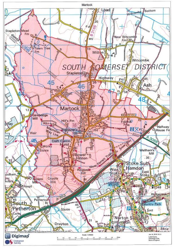
Date of versions:
                      Initial draft           March 2018

          1st consultation version        September 2018

          Pre-submission version                July 2019

              Submission version             January 2020

        Post Examination Version            February 2021

        Approved version (made)

Martock Parish Neighbourhood Plan – Post Examination Version   1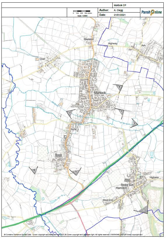
Martock Parish Neighbourhood Plan

Contents:

                Section:                                               page:
                                                         Foreword         3
                    1                                 Introduction        4
                    2                        Martock Parish Today         5
                    3                        The Strategic Context        6
                    4         Purpose of the Neighbourhood Plan           8
                    5                    The Structure of Our Plan       10
                    6                 Vision, Aims and Objectives        11
                    7                        Natural Environment         14
                    8             Built Environment and Heritage         27
                    9                                      Housing       42
                   10                              Local Economy         49
                   11                         Transport and Travel       54
                   12                       Community Wellbeing          58
                   13                          Monitoring the Plan       63
                   14                                     Glossary       63
                Maps:
                    1                         Neighbourhood Area          4
                    2                         Landscape Sensitivity      15
                    3      Landscape and Biodiversity (illustrative)     18
                    4                          Public Rights of Way      22
                    5                  Important Views and Vistas        25
                   6a                Local Green Spaces – Martock        32
                   6b          Local Green Spaces – Bower Hinton         33
                    7                   Settlement Area Boundary         38
                    8                             Local Green Gap        39
                    9                                Business Areas      51
                   10                  Martock Recreation Ground         62

     Maps in this report are reproduced under the Public Sector Mapping Agreement
        © Crown copyright [and database rights] (2014) OS license 100054346

            Martock Parish Neighbourhood Plan – Post Examination Version            2
Foreword
Welcome to the Post Examination Version of The Martock Parish Neighbourhood
Plan. This Plan has been developed by the community as a response to an
increasing number of controversial planning applications in the Parish and a desire
to exert more influence over how the parish of Martock develops in future. Four
years ago, I asked the Parish Council to consider the merits of a Neighbourhood
Plan and it was agreed to set up a Steering Group made up of local people to
formulate ideas whilst involving the whole community in the Plan’s preparation.
This Plan has been created through the hard work of several local people. Many
parishioners have helped by engaging with the regular consultations at the
monthly farmers’ markets and attending the several formal consultation events.
Whilst the Neighbourhood Plan is not in any way a bar to future building, it does
allow Martock to exercise more control and direction over the future
development, not only of housing but commercial sites and other aspects of
importance to our community, including the conservation areas, the design of
future buildings and access to leisure and recreation opportunities.
I would like to place on record my thanks to the members of the Steering Group
for having the stamina and determination to complete the challenge of producing
a Neighbourhood Plan; to everybody with an interest in the future of Martock who
has contribute their thoughts and ideas to the process; and to South Somerset
District Council for its encouragement and generally positive response to our
many queries and questions.
Neil Bloomfield
Chairman
Martock Parish Council                                                           February 2021

                  Martock Parish Neighbourhood Plan – Post Examination Version                   3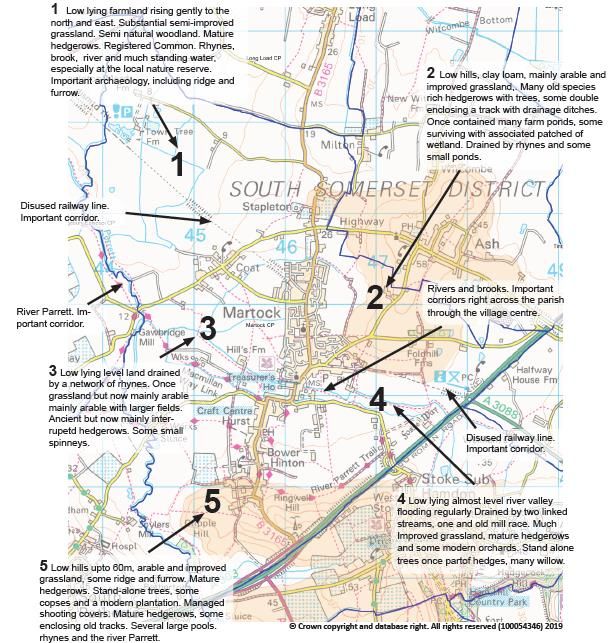
1. Introduction
The Plan Area
1.1   The Martock Parish Neighbourhood Plan applies to the parished area that is under the jurisdiction of
      Martock Parish Council. The plan area, which was designated as a neighbourhood area by South
      Somerset District Council on 7th April 2016, is shown on Map 1 below.

1.2   In the interest of clarity, all references to ‘Martock’ in this document apply to the whole of the Parish.
      The Village of Martock, the main settlement area in the Parish, is referred to throughout the
      document as ‘Martock village’. Other settlement areas are referred to by their name.

      Martock NP Map 1 – Neighbourhood Area

                    Martock Parish Neighbourhood Plan – Post Examination Version                                   4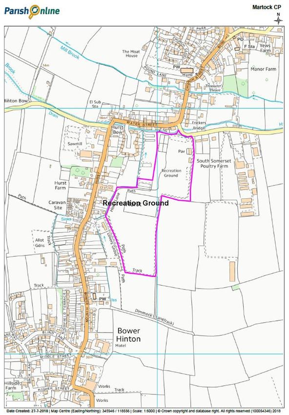
2. Martock Parish Today
Our Parish
2.1      Martock is an attractive Parish in central South Somerset, on the southern edge of the Somerset
         Levels and Moors and alongside the busy A303 trunk road. Madey Mill Stream and Hurst Brook flow
         between Martock and Bower Hinton to the South, before joining the River Parrett to the west. The
         main settlement of Martock is surrounded by gradual undulating hills that are regarded as having high
         landscape value. The local road network links Martock to Yeovil, seven miles to the southeast,
         although travel times vary considerably according to road conditions.

2.2     Martock village and the adjoining settlements of Hurst and Bower Hinton have a joint Conservation
        Area incorporating various listed buildings along the main road between the two settlements. Listed
        buildings are concentrated at the historic centres of Martock village, Hurst and Bower Hinton. Areas of
        significant flood risk run through the centre from east to west between Martock and Bower Hinton.
        The land either side of the streams has been identified as part of the functional flood plain.

2.3     The population of Martock Parish is approximately 4,2001. The village has a good variety of services.
        However, self-containment and sustainability, is an issue. The travel to work data for instance
        indicates that around 80% of the working population out-commute2, mainly to Yeovil, Taunton Deane,
        Crewkerne, and Ilchester and surrounds, even though the village of Martock is home to scores of small
        businesses that are clustered principally at Martock Industrial Park and the, out of town, Parrett
        Works. Redevelopment of sites, such as the former Paull’s Sailcloth factory, has resulted in a loss of
        employment land.

2.4     An overwhelming number of respondents to the recent Community Plan Household Survey 20173
        shared their opinion on what made them most proud of living in Martock. The friendliness, sense of
        community, willingness of volunteers and village atmosphere were high on the list. A large number
        also appreciated the beauty, architecture and history of the area, particularly the Church. The good
        range of shops, the post office, local independent businesses, the farmers’ market, and library are all
        popular, as well as the convenience of having doctors, dentist and a pharmacy in the Parish. Facilities
        such as the recreation ground, the shopping precinct, school, community rooms, fire station were all
        cited as things to be proud of.

1
  The 2011 Census recorded a population of 4,766 in the Parish of Martock. More recent estimates for 2018 give a
population of 4,188.
2
  From South Somerset Local Plan Review, Preferred Options Consultation Paper, South Somerset DC, Jun 2019
3
  http://www.martockonline.co.uk/UserFiles/File/1528.pdf
                       Martock Parish Neighbourhood Plan – Post Examination Version                                5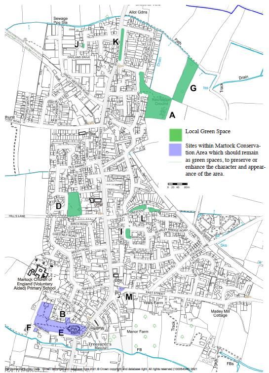
3. The Strategic Context
3.1        In preparing the Neighbourhood Plan we are obliged, by law, to:
           • have regard to national policies and advice contained in guidance issued by the Secretary of State
           • ensure the Plan is in general conformity with the strategic policies contained in the Local Plan

National Planning Policy Framework
3.2        In preparing the Neighbourhood Plan we have been cognisant of the current national planning
           framework. The 2019 National Planning Policy Framework (NPPF)4 sets out the Government’s planning
           policy to which all plans and proposals for development should comply. The NPPF includes, at its heart,
           a “presumption in favour of sustainable development” (NPPF para. 11). It states that “neighbourhood
           plans should support the delivery of strategic policies contained in local plans or spatial development
           strategies; and should shape and direct development that is outside of these strategic policies” (NPPF
           para. 13). The NPPF goes on to say that “strategic policies [in the Local Plan] should not extend to
           detailed matters that are more appropriately dealt with through neighbourhood plans” (NPPF para.
           21). Outside of strategic policies therefore, we are encouraged to shape and direct sustainable
           development in our area through our Neighbourhood Plan. “Neighbourhood planning gives
           communities the power to develop a shared vision for their area. Neighbourhood plans can shape,
           direct and help to deliver sustainable development, by influencing local planning decisions as part of
           the statutory development plan” (NPPF para. 29).

South Somerset Local Plan
3.3        The South Somerset Local Plan (2006 - 2028) sets out the long-term planning framework for the
           district up to the year 2028. “It represents the starting point for decisions on where development will
           be located in the district and will be used to reach conclusions on planning applications across South
           Somerset. It sets out the Council's objectives for providing enough homes, jobs and services, in an
           environmentally friendly and sustainable way to make the district prosperous both now and in the
           future.”5 South Somerset District Council adopted the South Somerset Local Plan on the 5th March
           2015. We are obliged to ensure that the policies of the Neighbourhood Plan are in general conformity
           with the strategic policies of the adopted Local Plan.

3.4        South Somerset District Council committed itself to an early review of the Local Plan (following
           concerns raised by the Inspector at the examination phase, regarding the housing and employment
           land allocations at Wincanton). The review (currently in progress at the time of writing) is being used
           as an opportunity to ensure that the whole Local Plan remains effective and up to date and will result
           in a new Local Plan covering the period 2014-2034.

3.5        During the summer of 2019, the Local Plan Review was at the ‘Preferred Options’ consultation stage. It
           is expected, by the District Council, that a new draft Local Plan will be ready for examination and
           subsequent adoption during 2021. The Martock Parish Neighbourhood Plan has been prepared in
           parallel with the Local Plan review process. We have endeavoured to ensure that the two plan-making
           exercises, particularly the local consultation aspects, have informed each other. We have been mindful
           of the emerging policies of the Local Plan review and striven to ensure that the policies in the
           Neighbourhood Plan are in general conformity with the strategic policies of the emerging new Local
           Plan as well as the adopted Local Plan.

4
    National Planning Policy Framework, Ministry of Homes Communities and Local Government, February 2019
5
    https://www.southsomerset.gov.uk/your-council/your-council-plan-and-strategies/planning-policy/local-plan/
                         Martock Parish Neighbourhood Plan – Post Examination Version                                6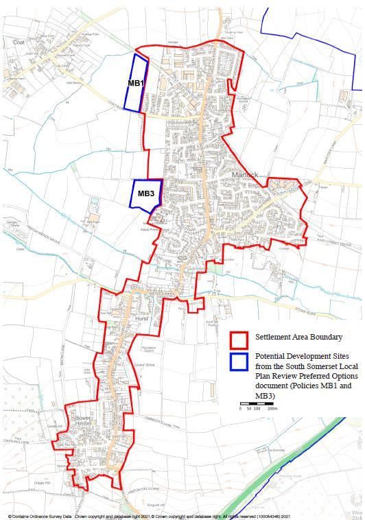
Martock Parish Council - Position Statement
3.6     The implication of new development on Martock’s sustainability is a matter that is taken very
        seriously. In 2013 Martock Parish Council adopted a Sustainable Development Plan6, which sought to
        provide a “strategic approach to the consideration of future planning applications for multiple
        residential dwellings over the short, medium and long term”. The Sustainable Development Plan was
        based on research which indicated that development scale is a significant factor in terms of impact on
        the current infrastructure.

3.7     At the time, it was agreed there was a need for “a realistic limitation being imposed on the number of
        units in any residential development and in terms of location of future residential development there
        are certain locations (areas) within the Parish that would have greater or lesser impact on the
        infrastructure and the existing residents”.

3.8    The Sustainable Development Plan set out a framework (based on a holistic approach) for the
       objective consideration of future planning applications. It included being fully cognisant of the local
       issues and opportunities, which are still pertinent at the time of preparing the Neighbourhood Plan:
       • the number of ‘pinch points’ caused by a combination of highway infrastructure evolution and
           design together with relatively high traffic volume and/or on-street parking – with implications for
           congestion, and public safety in particular
       • flood control and management concerns
       • The present and forecast capacity levels and constraints of the schools, surgery and other
           community resources
       • the location of recreational and welfare facilities e.g. surgery, pharmacy, schools, library services
       • The implication of the nature and scale of development on the rurality and vibrancy of the area
           and its communities.

3.9     It has been established through the consultation process undertaken for the, recently refreshed,
        Martock Community Plan7 and the Neighbourhood Plan that these matters remain important to the
        local community. The list of matters that people were “least proud of”, which came out of the 2017
        Community Plan Household Survey8, were traffic and parking in and around the village/Parish; the GP
        surgery with a critical lack of capacity, because it is unable to recruit enough doctors; the pharmacy,
        that is in need of improvement; the closure of public facilities, such as the bank and village pub; and
        the limited selection of shops and condition of the precinct, considered by some to be poorly designed
        and maintained.

3.10    The Community Plan Household Survey also established that a “large majority of respondents feel over
        the next 10 years, the Parish most needs more low-cost/starter homes for purchase (74%). This is
        closely aligned with those who feel that more affordable housing for local people who can’t afford
        open market housing will be needed (68%). While low carbon/eco-friendly housing is perceived as a
        need by the majority of 6 in 10 respondents (61%)”.

3.11    The neighbourhood planning agenda for Martock is therefore focussed on dealing with future
        development needs, protecting our special historic, built and natural environment, and addressing
        those matters of concern to the parishioners that can be affected by a land use plan.

6
  http://www.martockonline.co.uk/Pages/152/Sustainable-Development-Plan.html
7
  http://www.martockonline.co.uk/Pages/70/Local-Community-Plan.html
8
  http://www.martockonline.co.uk/UserFiles/File/1528.pdf
                     Martock Parish Neighbourhood Plan – Post Examination Version                                7
4. Purpose of the Neighbourhood Plan
4.1   Neighbourhood planning is intended to give communities direct power to develop a shared vision for
      their neighbourhood and shape the development and growth of the local area. The PPG says that, in
      accordance with the Localism Act 2011, the Parish Council, as a qualifying body is able to “choose
      where it wants new homes, shops and offices to be built, have our say on what those new buildings
      should look like and what infrastructure should be provided, and grant planning permission for the new
      buildings it wants to see go ahead”.

The Neighbourhood Planning Process
4.2   We approached the task with an open mind as to what the Martock Parish Neighbourhood Plan would
      cover and what its themes and purposes would be. We understood from the outset that it would have
      to meet some basic conditions:
      • have regard to national policies and advice contained in guidance issued by the Secretary of State
      • contributes to the achievement of sustainable development
      • is in general conformity with the strategic policies contained in the development plan for the area
          – the South Somerset Local Plan
      • does not breach, and is otherwise compatible with, EU obligations

4.3   With these conditions in mind, we have consulted widely and engaged with our local community to
      understand what is needed and determine what it is possible to influence and effect via a set of
      neighbourhood planning policies. We have considered carefully the policies of the Local Plan and
      assessed, on the basis of our agreed objectives, whether a more localised or detailed neighbourhood
      plan policy is necessary. In several instances, we have concluded that the Local Plan policy is sufficient.
      We have only introduced a neighbourhood plan policy where it will contribute to ensuring the area
      develops in the way we wish it to.

4.4   The Martock Parish Neighbourhood Plan sets out how we would like to see the area developed over
      the next 15 to 20 years and, through its policies, shape and direct sustainable development that will
      benefit those that live, work or visit in our area.

4.5   The development and preparation of the Martock Parish Neighbourhood Plan has been undertaken by
      a Steering Group comprised of local people and parish councillors, under auspices of Martock Parish
      Council.

4.6   It was understood from the outset that for the Plan to be truly representative of the planning issues of
      relevance in the area and to be the community’s plan, we needed to carry out a thorough and on-
      going consultation process with those who live and work in the area and those that visit here on a
      regular basis. We also recognised that the Plan could not be properly developed without the input of
      organisations and agencies with a district, county, sub-regional or national remit and an interest in the
      area.

4.7   The process and the types of consultation exercise and discussion that we have gone through is
      documented in detail in a Consultation Statement. The key methods we have used have included:
             • Public exhibitions, meetings and events
             • Regular, monthly, farmer’s market stall and topic-focussed consultation programme
             • Articles in the parish newsletter
             • Website and pages on parish website
             • Noticeboards and established poster sites
             • Focus groups and workshops
             • Surveys and discussions with local businesses and community groups
             • Correspondence with wider-than-local organisations and agencies (strategic stakeholders)
                 which have an interest in our planning issues
             • Two formal consultations during which comments have been invited on draft documents

                    Martock Parish Neighbourhood Plan – Post Examination Version                                8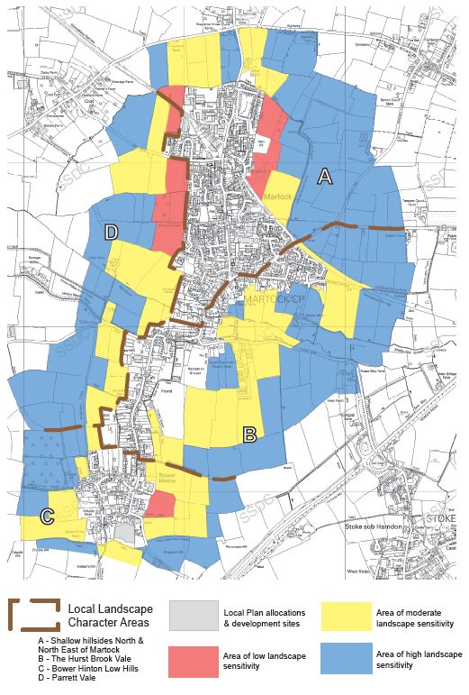
4.8    The development of the Martock Parish Neighbourhood Plan was based on a desire to be open and to
       welcome comments and contributions from all quarters. The intention has been to encourage and
       foster discussion and debate within the community about the issues and opportunities that face us
       and strive to achieve a community consensus. This Plan represents the product of this process.

The Plan’s Status
4.9    The Neighbourhood Plan, once ‘made’, will be a statutory development plan. That means that its
       policies will have significant influence when being used by the local planning authority to help
       determine proposals for development submitted through planning applications. It will form the local
       tier of planning policy in our Parish. It sits with the district-wide Local Plan, produced by South
       Somerset District Council (also a statutory development plan) and underneath the umbrella of national
       planning policy in the Government’s NPPF, as the main planning policy documents relevant to the
       Martock parish area. Other important planning documents which govern specific issues are the
       Minerals and Waste Plans produced at the county-wide level.

4.10   The Neighbourhood Plan’s policies cannot guarantee that a development proposal will be refused nor
       be granted permission, but the policies will carry significant weight, alongside policies of the NPPF and
       the South Somerset Local Plan when weighing up the appropriateness of the development proposal in
       question.

                     Martock Parish Neighbourhood Plan – Post Examination Version                              9
5. The Structure of Our Plan
5.1 The Martock Parish Neighbourhood Plan sets out the neighbourhood planning aims and objectives for
the neighbourhood area shown on Map 1. These have been developed following a dialogue with the
community and shaped by existing planning policies, plans and contributions of key organisations and
agencies.
5.2 Having explained our rationale for these, the Plan sets out planning policies for Martock Parish on a
topic-by-topic basis. Under each topic heading we summarise the characteristics of that topic and the
key issues which have been identified. The introduction to each topic is based on the findings of the
research, surveys and consultations that have taken place as part of the neighbourhood planning
process. More detail can be found in the Local Evidence Report 20169.
5.3 For each neighbourhood plan policy that follows we set out the policy statement; and our explanation
of and justification for the policy, including reference to the other planning policies in national and
district planning documents which relate to that policy.
5.4 We have given due consideration to the policies of the adopted South Somerset Local Plan. We are
wholly in accord with the Local Plan’s (Policy SS1) recognition of Martock/Bower Hinton, together, as a
rural centre “with a local service role where provision for development will be made that meets local
housing need, extends local services and supports economic activity appropriate to the scale of the
settlement”10. We have introduced a neighbourhood plan policy only where we feel it strengthens or
brings local specificity to the strategic approach and the policies in the Local Plan.
5.5 It is important to note that, while we have set out policies under topic headings, when development
proposals are being assessed, the whole plan (i.e. all policies) should be considered, as policies in one
topic may apply to proposals which naturally fit under another.
5.6 The Plan finishes with an explanation of how we will monitor and review the Neighbourhood Plan, and
a glossary which seeks to demystify some of the planning terminology used in the Plan.
Companion Documents
5.7 Several documents accompany the submitted version of the Neighbourhood Plan. We are obliged to
produce a Consultation Statement and a Basic Conditions Statement.
5.8 The Parish Council has also had prepared a Flood Guide, a Village Design Statement and Environment
Manual that are all available online11 to aid developers and help ensure that development proposals
will satisfy the requirements of the Neighbourhood Plan. These documents represent guidance only
but are specific to Martock Parish and are based on local evidence and knowledge.
5.9 The Neighbourhood Plan has been subject to testing as it developed to help determine its positive or
negative impact on the social, environmental and economic character of the neighbourhood area. A
‘screening opinion’ on the environmental effects of the Neighbourhood Plan and its policies was
sought from, the local planning authority, South Somerset District Council. The initial ‘screening
opinion’ from South Somerset District Council12 concluded “in the light of the District Council’s findings
and the responses from the statutory consultees it is concluded that there is no requirement for a full
Strategic Environmental Assessment (SEA) or Habitat Regulations Assessment (HRA) to be undertaken”.
Historic England and Natural England concurred with the local planning authority’s conclusions. This
opinion has been re-affirmed by the local planning authority based on the Submission Version of the
Martock Parish Neighbourhood Plan.
9
See full report at: http://www.martockplan.org.uk/Planpages/Documents/LocalContextReport.pdf
10
https://www.southsomerset.gov.uk/your-council/your-council-plan-and-strategies/planning-policy/local-plan/
11
http://www.martockplan.org.uk/
12
http://www.martockplan.org.uk/Drafts/Downloads/Martock%20SEA%20Screening%20Report%20Final%202019%20-
%20ISSUE.pdf
Martock Parish Neighbourhood Plan – Post Examination Version 106. Vision, Aims and Objectives
Establishing a Neighbourhood Plan Framework
6.1 The framework for the Martock Parish Neighbourhood Plan comprises:
• a vision - for the long-term future of Martock;
• the aims - that it is hoped that the Plan can help achieve; and
• the objectives - that we expect the Plan to attain by the application of appropriate neighbourhood
planning policies
Our Vision
6.2 A neighbourhood plan should set out a vision for the future of its neighbourhood. The vision should
reflect a desired end state that is consistent with the values and overall priorities of the community.
This is encapsulated in our vision statement below:
Living in harmony with our surroundings
The Aims and Objectives of the Neighbourhood Plan
Aims Objectives Policies
Vision
how we will what we want how we will
what we aim to
realise our to achieve with achieve our
become
vision the Plan objectives
6.3 The process of arriving at an agreed set of aims and objectives started with discussions at the
Neighbourhood Plan Steering Group, which considered the evidence and the response received to
surveys and other consultation activities. Much of the community-based evidence came from the
results of a community consultation undertaken during the Spring of 201713.
6.4 A draft set of aims and objectives was the focus of community consultation activity in the Parish during
November 2017. The response we received was positive and encouraging. As a result of the
community’s reaction and comments, several revisions were made to the draft aims and objectives.
The final set (see overleaf) was agreed in December 2017. We believe it reflects the community’s
neighbourhood planning and development agenda. It is this agenda that underpins the
Neighbourhood Plan’s policies.
13
Martock Community Plan Household Survey 2017, Conducted by the Community Council for Somerset, Report date 5
May 2017 http://www.martockonline.co.uk/UserFiles/File/1528.pdf
Martock Parish Neighbourhood Plan – Post Examination Version 11Agreed Aims and Objectives
6.5 The following set of aims and objectives was adopted by the Steering Group following community
consultation at the Martock Farmers Market on the Saturday 11th November 2017. As a result of the
community consultation, a few minor changes and additions were made to the consultation set agreed
at the Martock Steering Group meeting of the 6th November 201714.
Natural Environment
Aims Objectives
• Protect and enhance sensitive areas and habitats
Protect and enhance
• Further the creation of a network of wildlife corridors
our natural environment
• Prevent harm from development
• Support flood prevention measures
Improve flood resilience • Prevent development on land liable to flooding or
development that might increase flood risk elsewhere
• Extend and enhance public access to the countryside
Support responsible change • Enable necessary farm diversification
in the countryside • Responsible stewardship of the countryside
• Protect valued landscapes and views
Built Environment and Heritage
Aims Objectives
• Protect and enhance historic buildings and their settings
Respect the heritage and • Protect historical and archaeological sites
character of the area • Safeguard valuable green spaces within the settlements
• Retain the sense of villages and rurality
• Establish the limits of development
Ensure new development • Influence the design of new development
has a positive impact • Support sustainable development practices
• Ensure adequate infrastructure is in place
Support wider use of • Support small-scale renewable energy generation
renewable energy • Encourage low carbon development
Housing
Aims Objectives
• Establish a sustainable level of housing development
• Ensure new housing development is suitably mixed and
Ensure housing meets
reflects local needs
local needs
• Ensure housing offers realistic affordable options for local
people
• Support locally-based housing initiatives
Encourage innovative
• Support self-build projects
housing solutions
• Support energy-efficient housing design
14
http://martockplan.org.uk/Planpages/Documents/ConsultationReport.pdf
Martock Parish Neighbourhood Plan – Post Examination Version 12Local Economy
Aims Objectives
• Protect and enhance existing business and commercial areas
Facilitate the growth of local
• Support a wide variety of new business development
employment opportunities
• Facilitate high-speed electronic communication
Transport and Travel
Aims Objectives
• Increase safe cycling and walking routes
Reduce the impact of
• Support public transport initiatives
the motor vehicle
• Increase off-road parking opportunities
• Improve pedestrian routes
Improve safety and accessibility • Support traffic management initiatives
• Improve accessibility to services and facilities
Community Wellbeing
Aims Objectives
• Protect existing community facilities
Ensure community • Ensure community infrastructure is commensurate with
infrastructure meets local needs changing needs and demands
• Facilitate the local delivery of services
• Protect and enhance existing sport recreational and cultural
facilities
Encourage healthy leisure
• Support the provision of new facilities that meet local demands
and recreation activities
• Ensure the needs and demands of all age groups are
considered
Martock Parish Neighbourhood Plan – Post Examination Version 137. Natural Environment
Overview
7.1 Despite having a dense residential core, Martock Parish is predominantly rural in character with
extensive areas of countryside. In terms of ‘landscape character’, the South Somerset Landscape
Character Assessment, of 1993, determined the Parish comprises four distinct landscape character
areas:
A. Shallow hillsides North and North East of Martock
B. The Hurst Brook Vale
C. Bower Hinton Low Hills
D. Parrett Vale
7.2 Agricultural land in the Parish is mostly classified as grade 3b, with some 3a; several valley bottoms are
grade 2. A feature of the Parish is the number of small farms, with many small land ownerships.
7.3 The four landscape character areas are delineated on Map 2 below, which also shows the key findings
of a landscape sensitivity assessment published by South Somerset District Council in 2008. Its purpose
was to assess the capacity of the fringe areas of Martock/Bower Hinton to accommodate new
development in a landscape-sympathetic manner. The extent of land in the vicinity of the built-up area
that was categorised as an area of high or moderate landscape sensitivity is notable. This assessment
provides a valuable contribution in evaluating and minimising the environmental impact of
development proposals.
7.4 Whilst the Parish has not internationally or nationally designated sites, it is an area of diverse wildlife
habitats straddling, as it does, the edge of the wetlands associated with the Parrett vale to the west
and the higher land to the east beset with a variety of habitats that have evolved from the traditional
land use patterns such as ridge and furrow fields, old orchards, old droves with their ditches and
hedgerows and remnants of ancient woodland. There are two designated ‘local wildlife sites’ in the
Parish. There are other areas of the Parish that have been identified by local interest groups as being
important wildlife areas, such as Coathay Common, Parrett riverside and Cartgate Nature Area – their
ecological significance and value is still to be fully established.
7.5 The Parish is a very biodiverse area. The Somerset Environmental Records list many EU-protected
species and many of conservation concern, both plants and animals. Examples of protected species are
the nightingale, long-eared bat, yellowhammer, brown hairstreak butterfly and, in our streams, otter
and water vole, all indicating a rich diversity of important habitats that the Parish is actively engaged in
identifying, conserving, and developing.
7.6 The community generally enjoys good access to the countryside via an extensive footpath network,
which is well mapped (see Map 4) and regularly maintained (stiles, signposting, etc). The village is
surrounded by a network of 38 public footpaths, and recent consultation showed that these are well
used. Unfortunately, we do not have many bridleways. Many of the popular paths are not public but
are farm tracks. Some are permissive paths. Accessibility for the elderly and those requiring assisted
mobility is not good and there is a shortage of seats along popular routes. Paths generally are
inadequate for those with mobility problems. Cycleways do not exist and cycling in the village and
along many of the lanes can be hazardous.
7.7 Flooding and the risk of flooding is a matter of major concern in the Parish. The flood risk situation
around Martock village is complex. Within Martock village, there are pinch points that cannot cope at
times of high rainfall.
Martock Parish Neighbourhood Plan – Post Examination Version 147.8 The Martock Emergency Plan15 confirms that the following locations have been designated flooding
hotspots in the Parish:
• Parrett Works (Carey's Mill Bridge area - River Parrett)
• Stoke Road from Frickers Bridge eastwards along road by Hurst Brook)
• Hurst Bow Bridge (B 3165 - Hurst Brook)
• Gawbridge Bow
Flash flooding caused by drainage from agricultural land is common and not easy to predict.
Martock NP Map 2 – Landscape Sensitivity Assessment
Taken from the Martock Peripheral Landscape Study16
15
https://martockonline.co.uk/UserFiles/File/2341.pdf
16
https://www.southsomerset.gov.uk/media/1814/peripheral-landscape-study_martock.pdf
Martock Parish Neighbourhood Plan – Post Examination Version 15Our Neighbourhood Plan Policies and their Explanation/Justification
Policy No. Mart1 Protecting and Enhancing Biodiversity
Development proposals will be required to demonstrate how the design has taken into account
its potential impact on local wildlife habitats and species and realises opportunities for
biodiversity net gain and enhancing important habitats.
Development proposals that would result in either the loss of or unacceptable harm to an
existing area of natural habitat will not be supported unless proposed mitigation measures
would result in an effective solution to ensure that the integrity of the habitat continues after
the implementation of the development.
Due to the high levels of phosphates in the Somerset Levels and Moors, which represent a risk to
the designated Special Protection Area (SPA) and Ramsar site, Natural England advises that,
within certain types of development area, proposals will need to be subject to a Habitats
Regulations Assessment (HRA), proceeding to an Appropriate Assessment, before they are
submitted as planning applications. Developments which will result in a net increase in
population served by a wastewater system or increased nutrient loading from agriculture will be
required to undertake an HRA at an early stage, and to put forward mitigation measures to offset
any anticipated phosphate pollution.
7.9 The NPPF (para.174) requires us to “promote the conservation, restoration and enhancement of
priority habitats, ecological networks and the protection and recovery of priority species; and identify
and pursue opportunities for securing measurable net gains for biodiversity”. The South Somerset Local
Plan places protection on the sites of regional and local biodiversity, nationally and internationally
protected sites and sites of geological interest within the district.
7.10 Whilst there are not any internationally or nationally designated sites, the Parish is not without areas
of ecological or historical interest, such as ridge and furrow fields, old orchards, ancient woodland and
important hedgerows. The neighbourhood area also includes two designated ‘Local Wildlife Sites’ at
Bulsom Bridge Fields and Town Tree Farm. Our own recent surveys17 have identified a variety of
natural habitats in the neighbourhood area of varying characteristics. These include:
• Land alongside the river Parrett and its tributaries. This land is regularly flooded and includes
ponds, wetlands, riverine woodland, and semi-improved grassland. It has a significant population
of the larger mammals such as deer and badger, and also breeding populations of otter, water vole
and water shrew which are of conservation importance, as are some of the molluscs in the
streams. Birds include nesting swans, mallard, Canada geese, moorhen and kingfisher.
• The track of the old Somerset Railway. This mixture of cuttings and embankments with its
impoverished and well-drained soil has yielded a wide variety of flowering plants and scrub with
associated bird and invertebrate species, some quite are such as the nightingale.
• The old footpaths and droves around the village. Many of which were once used mainly for
moving cattle. They are wide with drainage ditches on both sites and edged with hedges, which in
many cases are now woodland avenues. These are important wildlife corridors.
• Bat habitats. Old buildings, trees and old hedgerows around the village have long been important
bat habitats. Recent surveys noted 11 of the 18-native species in and around Martock, including all
seven on the UK priority list.
• Cartgate Nature Area. A small area containing a pond, wetland, woodland and scrub including a
section of the old railway. It is managed as a nature area jointly by the village and Highways
England in a manner to attract rare species, particularly invertebrates.
17
http://www.martockplan.org.uk/Documents/Supportingdocs/EnvManual.pdf
Martock Parish Neighbourhood Plan – Post Examination Version 167.11 A detailed appraisal of the neighbourhood area’s natural environment and its ecological networks,
together with guidance for developers is set out in the Martock Environment Manual. Policy Mart1
requires developers to avoid causing damage or loss to local wildlife habitats whenever possible. It
also encourages developers to consider how they can help increase local biodiversity through the use
of appropriate streetlighting that will not adversely affect wildlife and the installation of robust swift
bricks, bat and owl boxes, and incorporating native local species in landscaping schemes.
7.12 As Martock lies within the catchment area of the Somerset Levels and Moors, a designated SPA and
Ramsar site, development proposals should respond to current guidelines from SSDC, Natural England
and the Environment Agency on preventing pollution from phosphates. Developers should investigate
the need for, and carry out a HRA/Appropriate Assessment, before submitting a planning application.
Developments which will result in a net increase in population served by a wastewater system or
increased nutrient loading from agriculture will be affected. SSDC is currently working with other
Councils across the County to develop a Nutrient/Water Quality Strategy, so that water quality issues
are fully understood, mitigation measures to offset phosphate pollution are devised, and mechanisms
to deliver future housing growth and other development in a sustainable way, are set out. Natural
England has provided updated advice to guide the approach to future development in the Ramsar site
catchment area. The catchment area covers most of South Somerset District, including all of Martock
Parish.
Policy No. Mart2 Landscape and Wildlife Corridors
Important established Landscape and Wildlife Corridors will be protected from development,
other than that required to maintain, enhance or interpret their landscape or wildlife purposes.
Where appropriate, development proposals should demonstrate they take the opportunity to
enhance and extend the network of Landscape and Wildlife Corridors as a means of mitigating
development impact with a focus on increasing biodiversity, wildlife value and general amenity
value of these corridors.
Where Landscape or Wildlife Corridors are disrupted as an unavoidable consequence of adjacent
or nearby development, developers will be required to minimise the impact and to carry out
remedial action in accordance with a scheme that shall be secured by way of planning condition
or planning obligation as appropriate.
7.13 Wildlife corridors are habitats that also connect wildlife populations and facilitate their movement.
There are many different kinds within the Parish, the more significant ones are the rivers and rhynes,
the old droves, important hedgerows and the disused railway line. Those considered important are
identified and analysed in the Martock Environment Manual18. The Map labelled ‘Martock Biodiversity’
from that document provides an overview of landscape and biodiversity and locates the important
corridors.
7.14 The NPPF (para. 174) requires us to minimise impacts on biodiversity and provide net gains in
biodiversity where possible and contribute to stemming the overall decline in biodiversity by
safeguarding “components of local wildlife-rich habitats and wider ecological networks, including…
wildlife corridors and stepping stones that connect them”. The wildlife corridors of the Parish are part
of an interlinked network of natural green spaces that stretches across the entire county and beyond;
and described as “the biodiversity equivalent of the national grid” by the Somerset Biodiversity
Strategy19. It states that “the bedrock of the network should be the conservation and management of
the remaining wildlife sites, with extensive habitat restoration and creation increasing the connections
between them.”
18
http://www.martockplan.org.uk/Documents/Supportingdocs/EnvManual.pdf
19
The Somerset Biodiversity Strategy 2008-2018
https://modgov.southsomerset.gov.uk/Data/District%20Executive/20081106/Agenda/8B.pdf%2006-11-2008.pdf
Martock Parish Neighbourhood Plan – Post Examination Version 177.15 The South Somerset Local Plan Policy EQ5 is aimed at ensuring the county’s green infrastructure
network is protected and enhanced by new development. It does recognise “green corridor links and
river corridor” as part of the wider network.
7.16 A coherent and resilient ecological network comprises “high quality sites, protected by buffer zones,
and connected by wildlife corridors and smaller, but still wildlife-rich, stepping-stone sites”20. Policy
Mart2 places emphasis on the established wildlife corridors of the Parish as identified in the Martock
Environment Manual and shown on Map 3 of this Plan, which should be protected to allow species to
move and ensure our ecosystem functions properly. Development proposals should avoid causing
damage to these vital corridors and every opportunity should be taken within a new development to
enhance the network and include ‘stepping stone’ sites.
Martock NP Map 3 – Landscape and Biodiversity (illustrative only)21
Nb. A larger-scale version of this map can be viewed in the Martock Environment Manual
20
Biodiversity 2020: A Strategy for England’s Wildlife and Ecosystem Services, DEFRA, 2011
https://assets.publishing.service.gov.uk/government/uploads/system/uploads/attachment_data/file/69446/pb13583-
biodiversity-strategy-2020-111111.pdf
21
Martock Biodiversity Map showing five different areas around the village and the two important corridors that bisect
the parish, the disused railway line and the Hurst Brook valley.
Martock Parish Neighbourhood Plan – Post Examination Version 18Policy No. Mart3 Flood Management
Proposals to improve the management of water courses and construct new defences to minimise
flooding will generally be supported.
In improving flood defences, opportunities shall be taken to enhance biodiversity.
7.17 There is only one river in the Parish which flows south to north, whereas ‘main river’, (Hurst Brook and
Hinton Meads Brook), flows east to west and then into the River Parrett. There are numerous streams,
brooks, rhynes and other water courses which impact on flooding in the Parish. Several areas of the
Parish are very prone to flooding and flooding is becoming a more regular occurrence. Following major
flood incidents in 2012 and over the winter of 2013/14, Martock has maintained an Emergency Plan22
and a Flood Warden Management Scheme, which has authority to close roads when, in the opinion of
the flood wardens, safety is a concern. The flood risk situation around the main settlement area is
complex and worsened by an old, undocumented and unexamined drainage system. The Martock
Flood Alleviation Scheme, which is maintained by the Environment Agency, was constructed in the
1970's to a 1 in 10 standard with the intention of protecting properties from flooding. The Scheme was
designed to direct flood water on to the main route to/from the village and the A303 dual
carriageway, with the potential danger and disruption to road users. The authorities have not notified
of any critical drainage areas23 in the Parish.
7.18 Martock has always suffered from periodic flooding and steps are continually being taken to reduce
this risk. Climate change has, however, increased both the amount of rainfall and the frequency of
heavy storms. In consequence the Parish has developed robust strategies for addressing the issue and
minimising flood damage. Prevention and the reduction of flood risk is a critical aim, that has been
recognised by the Neighbourhood Plan. Policy Mart3 is supportive in principle of all types of measures
that will reduce flood risk, including the construction of new permanent flood defences. It is part of a
comprehensive local strategy to reduce floods and the risk of flooding. Martock Parish Council will
seek to ensure that existing flood prevention measures are adequately maintained by the respective
authorities and landowners, including, sustainable drainage systems (SuDS), penstocks, weirs, dams,
trash screens etc., together with the required annual maintenance of all those water courses in areas
which are susceptible to flooding. The Parish Council will maintain liaison with parishes in the upper
reaches of the Martock rainfall catchment area, with a view to reducing the impact of flooding
downstream, by introducing structures compatible with the Hills to Levels aims. Agricultural practices
which increase the run-off from land and overload the local drainage network will be discouraged and
landowners requested to follow accepted farming principles of land management which minimise the
flood risk to the community.
7.19 All water courses provide shelter and feeding opportunities for a wide range of plants and animals.
The Government advises that “physical modification is one of the main reasons why many rivers do not
support thriving wildlife. Engineering and other changes to natural river forms have damaged habitats,
reducing populations of plants and animals and reducing their ability to cope with extreme low and
high river flows”24. Advice should be taken by those carrying out flood defence works, from bodies
such as the Farmers Wildlife Action Group, (FWAG), Natural England, (NE), together with Somerset
Wildlife Trust, on how they can avoid damaging habitats and include measures to improve and
enhance local biodiversity, by working with nature not against it.
7.20 In the light of the new guidance from Natural England, regarding the concern of phosphate effluent
new developments affecting the Somerset Levels and Moors, which is a Ramsar site, each
development should now include a Habitats Regulations Assessment, carried out by a competent
authority (e.g. the local planning authority), proceeding to an Appropriate Assessment. This has to be
addressed prior to submission of a planning application; it will not be acceptable simply to impose a
condition on a planning permission to address the issue.
22
http://www.martockonline.co.uk/UserFiles/File/1623.pdf
23
as defined by the Town and Country Planning (General Development Procedure) (Amendment) (No. 2) (England) Order
2006
24
https://www.gov.uk/government/publications/improving-river-habitats-to-support-wildlife-during-low-flows
Martock Parish Neighbourhood Plan – Post Examination Version 19Policy No. Mart4 Flood Risk
Where appropriate, development proposals shall demonstrate that they do not increase local flood
risk, with particular regard to locations of known surface, fluvial and reservoir flooding, identified
on up-to-date flood risk maps; or heighten flood risk further downstream.
Wherever practicable and appropriate, development proposals should incorporate a Sustainable
Drainage System (SUDS) to minimise flood risk. Where sustainable drainage systems are introduced,
a satisfactory management plan must be put in place for future maintenance of the system.
7.21 Flooding and the risk of flooding is a matter of great concern to the parishioners of Martock, as it is for
much of South Somerset. In facilitating good sustainable development, we have been keen to ensure
that local planning policies:
• steer development to areas of lower flood risk as far as possible
• promote the use SuDS
• maximise the use of ‘natural’ SuDS features
• promote water efficiency in new development
• encourage measures such as tree planting, street trees, rain gardens and green roofs through new
development (see Martock Design Statement)
7.22 The Parish has been building its data-base and understanding of the local ‘flood issues’ and the
complex causes of floods in the area; and potential solutions. There is no panacea. The PPG advises
that “new development should only be considered appropriate in areas at risk of flooding if priority has
been given to the use of sustainable drainage systems”25.
7.23 Flooding has always been commonplace in the village and is likely to worsen in the future. All
development on greenfield land and on brownfield land where the development will alter the existing
drainage patterns should incorporate proposals such as a SuDS that will ensure that surface run-off is
not increased by the proposal and where possible, decreased.
7.24 SuDS should be considered for all new developments and may be the answer in many locations. But
their success is very dependent on soil type and permeability, which can vary seasonally and varies
considerably throughout the area. For this reason, flood risk assessors should carry out on-site
assessments of permeability rather than using online data which, for this area, is insufficiently well-
defined. Any SuDS system needs to be designed with its specific location in mind and include an
adequate management plan to ensure it remains functional and fit for purpose and takes account of
seasonal and long-term climate change. The use of automatic mechanisms for releasing flood water
from sustainable drainage retention ponds will not be supported as they tend to release water
downstream at the moment when downstream flood risk is greatest. Policy Mart4 supports the use of
a relevant and effective SuDS system wherever it is practicable to do so.
7.25 Most importantly, given that much of the area is at risk, all relevant development proposals need to
demonstrate that they have considered drainage in the context of the identified local flood risk and
included the necessary measures to avoid contributing to the flood risk. Development at or within
close proximity of Flood Zones 3 or 2, or at areas at risk of flooding, should be avoided whenever
possible, together with sites of 1 hectare or more, as advised by the PPG26, developers must undertake
a site-specific flood risk assessment to accompany applications for planning permission (or prior
approval for certain types of permitted development).
7.26 Martock Parish Council has produced the Martock Parish Flood Guide for Developers27, based on local
knowledge and experience. We hope it will inform the development of efficient and effective
sustainable drainage systems wherever possible. The Guide emphasises the need to ensure that a site-
specific maintenance plan is considered from the outset and its preparation is part of the SuDs
planning and design process. The Maintenance Plan should be in place by the time the development
takes place.
25
PPG Paragraph: 079 Reference ID: 7-079-20150415
26
PPG Paragraph: 001 Reference ID: 7-001-20140306
27
http://www.martockplan.org.uk/Documents/Supportingdocs/FloodGuide.pdf
Martock Parish Neighbourhood Plan – Post Examination Version 20Policy No. Mart5 Public Rights of Way
Development proposals to improve accessibility and extend local footpaths, bridleways and cycle
paths and help connect them to the wider networks will be supported.
The construction and appearance of new paths, tracks or links must be appropriate and sensitive
to the character of the locality and enhance the green infrastructure network wherever possible.
7.27 The community generally enjoys good access to the countryside via a ubiquitous and excellent
footpath network, which is well mapped and regularly maintained (stiles, signposting, etc). It includes
the long-distance footpath, the Parrett Trail. The recent M3CP28 survey has identified the paths around
the recreation ground as the most popular. Many popular paths are not public but are farm tracks;
some are permissive paths. Unfortunately, we only have two bridleways. The NPPF (para. 98) makes
plain that policies and decisions should “protect and enhance public rights of way and access, including
taking opportunities to provide better facilities for users”.
7.28 The current network of paths and bridleways in the countryside is shown on Map 4. They are all
mapped and described in detail on the Martock Online website29. Many rights of way also serve as vital
wildlife corridors through the agricultural landscape and give people contact with the natural world
which contributes to their own wellbeing.
7.29 There are no off-road cycle routes in the Parish. A third of respondents to the Martock Community
Plan Household Survey 201730 wanted to see some footpaths made into cycleways.
7.30 Access to the countryside for the elderly and those requiring assisted mobility is not good and there is
a shortage of seats along popular routes. Paths generally are inadequate for those with mobility
problems. Policy Mart5 supports measures to improve accessibility and extend the rights of way
network in the countryside as long as it can be done without causing long-term harm to local
biodiversity in contravention of Local Plan Policy EQ4 and policy Mart2 in the Neighbourhood Plan. If
done sensitively improvements could also help extend the wildlife corridors and network of green
infrastructure.
7.31 Public rights of way are an important part of our cultural heritage and enable young and old alike to
explore the local countryside and experience its rich and diverse history, wildlife and landscape. They
also an important means of helping people to escape the hustle and bustle of modern life, to get back
to nature and keep physically and mentally fit. The Parish Council encourages local volunteers and
groups who give up their time to help Somerset County Council look after the footpath network. The
Parish Council would be a willing participant in a district-wide improvement strategy to ensure the
public rights of way network continues to function properly.
28
M3CP = Martock Community Partnership
29
http://www.martockonline.co.uk/Pages/159/Parish-footpath-list-and-map.html
30
http://www.martockonline.co.uk/UserFiles/File/1528.pdf
Martock Parish Neighbourhood Plan – Post Examination Version 21Martock NP Map 4 – Public Rights of Way
Martock Parish Neighbourhood Plan – Post Examination Version 22Policy No. Mart6 Development in the Countryside
Development in the countryside will be supported if:
i. it is necessary for the purposes of agriculture, farm diversification or outdoor recreation;
ii. it demonstrates a positive contribution to the preservation and enhancement of the
countryside, its landscape and its biodiversity;
iii. it facilitates responsible use and enjoyment of the countryside by the public;
iv. it does not cause harm to publicly accessible open space, footpaths or bridleways;
v. it does not impact negatively on important views and vistas to/from settlements;
vi. it does not cause harm to scheduled ancient monuments and other sites of archaeological
interest, including ridge and furrow; and
vii. it does not impact negatively on the best and most versatile agricultural land, or the
integral character, beauty and tranquillity of the countryside.
7.32 Development in the countryside, i.e. outside of the confines of the settlement areas, is restricted but
will be supported if it is necessary for those purposes for which the countryside is normally used such
as equestrian and farming-related activity and outdoor recreation. The NPPF (para. 170) says
“planning policies should contribute to and enhance the natural and local environment by protecting
and enhancing valued landscapes and recognising the intrinsic character and beauty of the
countryside, and the wider benefits from natural capital and ecosystem services”.
7.33 Policy Mart6 recognises that development may be necessary to ensure that an existing farming
business can continue to function, and the countryside is an appropriate location for some types of
outdoor recreation activities. Community surveys have shown support for responsible use of the
countryside for recreation purposes.
7.34 Policy Mart6 is supportive of development and uses that will not cause harm to the rural character of
the area or result in the loss of countryside assets such as public rights of way, higher grade (2 and 3A)
agricultural land, key biodiversity features such as wildlife corridors, rhynes and ponds, important
hedges, unimproved grassland, and heritage features and buildings such as milestones, boundary
stones, fingerposts and old railway features. Its purpose is to ensure that development that does take
place is relevant and necessary and does as little harm to our countryside assets as possible.
Policy No. Mart7 Farm Diversification
The conversion of existing agricultural buildings for business or business-related purposes will be
supported where it is justified in the interests of ensuring the continued viability of the farming
business and where the proposal can demonstrate that there would be:
i. no harmful impact upon the surrounding rural landscape;
ii. no unacceptable conflicts with agriculture and other land-based activities;
iii. no harmful impact on the local road network;
iv. no harmful impact on the amenities of neighbouring residents or businesses; and
v. no requirement for rebuilding or a disproportionate extension.
Converted business space permitted by this policy must remain as its approved use unless it has
been actively marketed for two years and it can be demonstrated that no demand exists for its
continuation for employment purposes. In such cases, the redundant space should revert to its
former use.
7.35 Farming is still important to the Parish. A feature of Martock is the number of small farms, made up of
even smaller land ownerships, which has helped to describe the character of the local landscape. We
wish to ensure that farming continues to prosper not least because it will help to maintain the
landscape we so enjoy. The NPPF (para. 83) says “planning policies and decisions should enable the
development and diversification of agricultural and other land-based rural businesses”.
Martock Parish Neighbourhood Plan – Post Examination Version 23You can also read