Schools Property Planning Competition Manual 2020 - Local ...
←
→
Page content transcription
If your browser does not render page correctly, please read the page content below
Schools Property Planning Competition Manual 2020
Published by Local Land Services
Schools Property Planning Competition Manual 2020
First published April 2020

More information
Johnelle Stevens Northern Tablelands Local Land Services Farm Planner
www.lls.nsw.gov.au
Acknowledgments
Meat and Livestock Australia (MLA)
Regional Development Australia, Northern Inland NSW
University of New England
© State of New South Wales through Local Land Services, 2020.
Disclaimer: The information contained in this publication is based on knowledge and understanding at the time of writing April 2020.
However, because of advances in knowledge, users are reminded of the need to ensure that information upon which they rely is up to date
and to check currency of the information with the appropriate officer of Local Land Services or the user’s independent adviser.
Introduction for Teachers                                      1
  Timetable for 2020                                           1
  Syllabus Links                                               1
  Getting Started                                              2
  What is a Property Plan?                                     3
  The Property Planning Process                                3
  Your Property Planning Competition Task                      3
  Report Requirements                                          5
Property Information                                           6
  About Brookfield                                             6
  Landholders’ Aims and Values                                 7
  Landholders’ Priorities                                      7
  Maps                                                         8
Stocktake of Resources                                          9
  Climate                                                       9
  Contours and Drainage                                        10
  Infrastructure                                               11
  Vegetation                                                   11
  Biodiversity                                                 13
  Land Capability                                              17
  Land Management and Erosion Risk                             19
  Soils                                                        19
  Water Quality                                                22
  Salinity                                                     25
Biosecurity                                                    27
  What is Biosecurity?                                         27
  Farm Biosecurity                                             27
  Priority Areas for Farm Biosecurity                          28
  Livestock Diseases                                           28
  Toxins and Chemical Residues                                 28
  Pest Animals                                                 29
  Weeds                                                        32
Emergency Issues                                               33
Cultural Heritage                                              34
 Aboriginal Cultural Heritage                                  34
 Preserving Aboriginal Cultural Heritage on Private Property   35
Farm Business Planning                                         36
  Farm Business Enterprises                                    36
  Financial Information for Farm Decision Making               36
  Pasture Management                                           37
Developing the Farm Plan                                       40
 Land Use Hazards                                              40
 Rainfall Use Efficiency                                       40
 Legal Obligations                                             42
 Making Decisions on Land Use                                  44

Local Land Services April 2020                                  ii
Monitoring                                                                                     44
  The Plan and Report                                                                            45
Further Resources                                                                                51
References and Further Information                                                               53
Glossary                                                                                         55
Appendix                                                                                          57
 Appendix 1 – Maps                                                                                57
 Appendix 2 - Vegetation Species List                                                             61
   Common flora found on and around Brookfield (including planted tree lines)                     61
 Appendix 3 - Fauna Species List                                                                  62
   Common fauna found on and around Brookfield * Indicates introduced species ^ threatened species
                                                                                                  62
 Appendix 4 – Student Entry Package                                                                1
Acknowledgments                                                                                   3

Local Land Services April 2020                                                                    iii
Introduction for Teachers

Timetable for 2020

                   Date                                                        Event
      Friday 24th April 2020                    Closing date for school registrations to attend the field day.
                                                         Resources will be available online by the 24th April
                                                          Web address will be sent out closer to the date

       Friday 3rd July 2020                              The two best entries per school due for marking.
                                                          Post to: Property Planning Competition Entries,
                                                                     Northern Tablelands LLS,
                                                             142 High Street, Tenterfield NSW 2372 or
                                                             Email to: johnelle.stevens@lls.nsw.gov.au

       18-20th August 2020                                     Awards Ceremony: AgQuip Gunnedah
  exact details to be advised                                134 Black Jack Rd, Gunnedah NSW 2380

   The Schools Property Planning Competition is designed to give students an
  opportunity to study a local rural property in detail. The students are required to
  prepare a plan that provides for long term profitability as well as sustaining the
   natural resources of the area. The exercise draws together a number of land
   management themes and gives students the chance to apply their skills and
                          knowledge to a real-life situation.

Syllabus Links
The Schools Property Planning Competition has been designed to address numerous
outcomes of TAFE Agriculture courses, the School Certificate and HCS Agriculture syllabus,
particularly the Farm Case Study unit. Links can also be made to the HSC Geography syllabus
and the VET Primary Industries curriculum. Because the activity has been structured to
accommodate students studying a range of subjects and abilities, teachers will need to
determine the depth of study undertaken. A marking schedule is provided in Appendix 4, which
will be used to judge entries submitted.

1 Property Planning Competition Manual Brookfield 2020
Getting Started
Each student and/or group (maximum of four per group) should be given a copy of all the
relevant resources. In addition, students should access other resources from libraries,
government departments and the internet.
To participate in the Schools Property Planning Competition you need to :
• Download and print the manual, maps, field day workbook, and student entry package and
   other information that will be provided to you by Northern Tablelands LLS
• Students can submit an individual entry or a group entry with a maximum of four students
   per group
• Include the student entry package (template shown in Appendix 5 and provided) for each
   entry with the name of your school, class name and all the contributing students names
   clearly marked
• Only send the best two entries per school to Northern Tablelands Local Land Services.
   (address is included in the timetable page 3)f.

2 Property Planning Competition Manual Brookfield 2020
Agriculture students from Northern Tablelands have been invited to use Brookfield for their
farm case study.

What is a Property Plan?
A property plan assists the landholder to develop a productive and profitable farming business
through improving the natural resource base on their property (Figure 1). Property planning
enables landholders to identify what is holding them back, maintain farm financial viability,
enhance their capacity to utilise ‘free’ natural resources, manage risks proactively, build
resilience to withstand climate variability and to develop a framework for fulfilling their farm’s
potential. It is:
    •    A written management plan for a farm business which takes a holistic whole farm
         approach: property layout, land use, land capability, financial planning, risk
         management and people management
    •    A tool for farmers to clarify their vision and goals, develop management plans to achieve
         these goals and take action
    •    A process that identifies opportunities for
         business improvement and assists farmers to
         move towards more sustainable practices
         through knowledge gained.

The Property Planning Process
    •    Develop your vision, values and set goals
    •    Assess your current situation
    •    Plan actions to take you from where you are to
         where you want to be
    •    Monitor
    •    Review and replan.                                              Figure 1: Property Management Planning
                                                                                      (Brouwer 2012)
Your Property Planning Competition Task

Students should use the information provided in this manual and the information collected from
    further research to develop a property plan. Each student or group of students has been
hypothetically contracted by the owners of Brookfield to make an assessment of their current
  farm production system and to recommend improvements which will enhance future farm
                                            profitability and sustainability.

3 Property Planning Competition Manual Brookfield 2020
Your Property Plan report for Brookfield will take into account:
• The aims of the landholders
• Natural characteristics of the land, water and vegetation
• Minimise land and water degradation by identifying existing and potential problem areas
  and adapting management accordingly
• Social, legal and economic aspects
• Maximising profitability through appropriate enterprise selection, production systems and
  marketing options
• Appropriate risk management strategies
• Appropriate monitoring options for recommendations made.

Property Plan Components
    • Mapped physical property plan with recommendations clearly marked
    • A written report explaining these recommendations and addressing the marking criteria.

WORD LIMIT FOR WRITTEN REPORT IS 3500 WORDS.
Essential components of your Property Plan:
As per the Marking Criteria (Appendix 5):
•     Consider land capability in land use and management strategy recommendations
•     Address land use issues identified in this manual
•     Appropriate enterprise selection and suitability in line with landholder aims, labour
      requirements, profit, farm design, natural resource base, environmental impact and
      marketing options
•     All recommendations show consideration of land managers’ aims and conditions
•     Map presentation reflecting the plan
•     Report presentation, including structure: introduction, body, conclusion, or follow the
      student entry package
•     Use of resource information provided: manual, maps, field day work book
•     Legal considerations accounted for
•     Funding considered. Funding options relevant to your recommendations, for example:
        • farm cash flow
        • banks
        • NSW Rural Assistance Authority
        • Northern Tablelands Local Land Services
        • Landcare
•     Use of other resources
•     Monitoring
•     Biosecurity and emergency planning.

What the judges look for:
•     Presentation
•     Precise, clear and brief report
•     Quality ideas
4 Property Planning Competition Manual Brookfield 2020
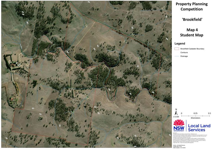
•    Consistency with landholders’ vision
•    Consideration of marking criteria and template

Marks will be deducted for exceeding the word limit of 3500 words.

Report Requirements
To enter the 2020 Schools Property Planning Competition, each student/group of students will
need to submit the following:
1. A physical property plan (map with recommendations clearly marked) (see Map 4,
   Appendix 1)
2. A written report as per the Student Entry Package (word limit 3,500 words) explaining the
   recommendations and addressing the marking criteria (Appendix 5).

5 Property Planning Competition Manual Brookfield 2020
Property Information
About Brookfield
Location
Brookfield is located at 2570 Guyra-Ebor Road, Guyra NSW 2365. The property is
approximately 25 kilometres (km) East of Guyra towards Ebor.
Background and History
Darryl and Leanne Savage are fifth generation owners of Brookfield, and their four children are
sixth generation. Brookfield was a settlement block and there is a long and proud history of
taking care of this beloved property and they are all really excited for that to continue long into
the future. Leanne’s great grandfather was responsible for the clearing of the native vegetation
and, as you can see on the map, the ridges were not cleared like other properties in the area.
The property was also fenced as close as possible to land type and some paddocks have had
improved pastures established in the last 30 years.
Current Farming Operation
The Savage family are absentee
landholders. They live most of the year
on their property Teaghlaigh outside
Ipswich in South East Queensland, where
their children are completing school.
Darryl and Leanne took ownership of
Brookfield ten years ago however have
had it leased to another local cattle
producer until the 1st of January 2020.
Brookfield was recently in drought
receiving below average rainfall, for the
last two years, and is stocked with a                             Photo: L. Savage
handful of cows and calves and weaner
steers that the Savages have brought down from their Qld farm, which has also been in
drought, while both farms have had good rain, they both still have a deficit in soil moisture.
The plan, at this time, is for Brookfield to only run 50 head of cows and calves this year as a
drought buffer until they start receiving normal or near normal rainfall events and they have a
plan in place to manage Brookfield from interstate. The carrying capacity of Brookfield in a
normal to good season is 180-200 head of cows. The Savages are looking to stock
conservatively and run only 100 head of cows and calves each year.
The Savages are planning to operate differently from most local producers as they are not
going to target the local weaner sales. They are planning to have a self-replacing herd, and
fatten cull cattle to 380-400kg on Brookfield to then be transported interstate to Teaghlaigh to
finish on irrigated pasture. They will then be sold straight into the local Dinmore meatworks.
This will enable them to change their joining period to December/January and have calving in
September with a good spring.
6 Property Planning Competition Manual Brookfield 2020
While Brookfield has run first cross ewes and merino wethers in the past, the current owners
are not including sheep into their enterprise at this time, due to the shearing shed being
decommissioned and being absentee landholders.

Landholders’ Aims and Values
                                                         The Savages have a very proud history with
                                                         Brookfield and are working hard to keep it in
                                                         the family. There is a strong appreciation of
                                                         their history and the natural resources and
                                                         environment are of high value. As such,
                                                         family involvement and succession is
                                                         important.
                                                         “We believe that having the family involved in
                                                         Brookfield will help to instil the family values
                                                         and teach business skills, cultivating ideas
                                                         and providing opportunities for our children
                     Photo: L. Savage                    and for future generations” said Leanne
                                                         Savage.
“For example, our four children will all be finished school in the next seven years and we are
hoping Brookfield will provide an opportunity for them to manage a rural enterprise and
develop their own enterprise/business” said Leanne.
Through the Property Planning Competition, Darryl and Leanne are interested to hear the
ideas from the students taking part, as Brookfield is a blank canvas at the moment and there
are many opportunities to be explored.

Landholders’ Priorities
•    Brookfield needs to make money and stand on its own without input from the Savage’s
     other business. However there is the opportunity to be integrated with their Queensland
     property.
•    Water infrastructure and security is a priority. The dam went dry in the recent drought and
     the creek went dry around four years ago.
•    Technology to monitor the property while the landholders are absent, for example security
     cameras at the gate that have live feedback, water telemetrics on any new or existing
     water infrastructure.
•    Any improvements, if intensive, need to be able to generate enough income to employ
     people to oversee or manage. Budgets also need to include contractor rates i.e. a fencing
     contractor will be required to complete any new fencing, as the savages won’t be able to
     complete this themselves.
•    Biosecurity – keeping as weed free as possible. Brookfield has always had a self-replacing
     herd however, with the recent conditions, the Savages will need to buy in cows to build

7 Property Planning Competition Manual Brookfield 2020
their herd again, and this will increase the weed risk. With Chilean Needle Grass not far
from the boundary, this is a high priority for the landholders.
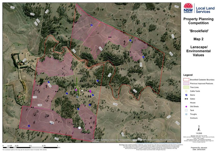
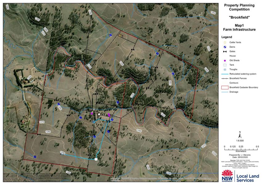
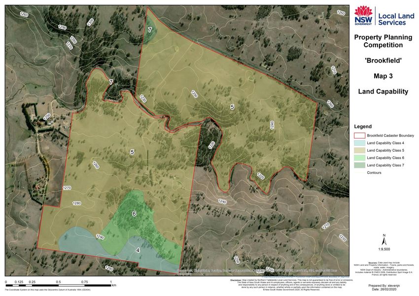
Maps
Students are provided with several maps to assist them to undertake their property mapping
(Appendix 1). The maps include:
• Map 1 “Brookfield Farm Infrastructure” which includes all infrastructure and biophysical
information (this should be viewed at large A1 size so that the details of the map can be
seen clearly. Maps will be posted to each school)
• Map 2 “Brookfield Landscape/Environmental Values” which displays the terrain, water
courses, native vegetation plantings and provides a landscape context to the property
• Map 3 “Brookfield Land Capability” which displays land capability classes for the property
• Map 4 “Brookfield Student Map” is a blank map for students to draw their property planning
developments onto
These maps should assist students to consider infrastructure requirements, water quality
issues, livestock, pasture and grazing management and to assist them to develop a
biodiversity plan for the property. Blank maps will also be provided to students in order to
assist them to fill in their property plan.
Photo: J. Stevens
8 Property Planning Competition Manual Brookfield 2020Stocktake of Resources
Climate
Figure 2: Mean maximum temperature for
Brookfield 1970-2019
(Source: Bureau of Meteorology 2019)
Figure 3: Mean minimum temperature for
Brookfield 1970-2019
(Source: Bureau of Meteorology 2019)
Figure 4: Mean rainfall (mm) for Brookfield
1910-2019
(Source: Bureau of Meteorology 2019)
More climatic information is available at: www.bom.gov.au/climate/data/
9 Property Planning Competition Manual Brookfield 2020Key points
• Rainfall amount and seasonality
determines the growth of pasture
and limits the ability to grow crops
in an area. It also influences
erosion hazard, flooding hazard
and groundwater levels.
• The amount of rainfall influences
stream flow to lower areas and
groundwater levels through deep
drainage.
• Temperature will affect plant
growth and stock nutritional needs;
management of the property needs Photo: B. Rosenberg
to consider how the effects of
temperature can be managed.
• Wind speed and direction influence water use by crops and pastures, and are important
considerations when determining sites for wind breaks or stock shelter areas.
Contours and Drainage
Brookfield is located at the top of the Great Dividing Range, towards the top of the Clarence
Catchments. A number of smaller watercourses run through the property (see maps for
drainage). The map also shows contours, which represent lines of uniform elevation, with a
constant interval in height (10m) between them. This means that, where contours are spaced
more closely together, the land surface is steeper, so may require conservative management
to offset the potential erosion hazard. The contour lines range from 1,220 to 1,290m above sea
level (ASL) with some parts of the property being reasonably flat and others having gentle
undulations. Salinity is not considered to be an issue on this property as this region is not
prone to salinity.
Key points
• Drainage lines, watercourses and riparian vegetation must be retained and carefully
managed. They are especially at risk of erosion if cultivated or overgrazed. Often these
areas contain native vegetation and are important for biodiversity.
• Streams require flows periodically to maintain riparian vegetation. It is important not to cut
off the small flows to streams, riparian areas and aquatic ecosystems in dry periods.
Maintaining flow in watercourses and streams is important for environmental reasons, for
downstream stock and domestic water supply, and for downstream agriculture and
industry.
10 Property Planning Competition Manual Brookfield 2020Infrastructure
• Shearing shed (is unusable and has
been decommissioned)
• A ten year old set of steel cattle yards,
small but functional
• House and house/horse paddocks,
currently rented for extra security on the
property
• Most internal fencing is old and needs
replacing
• A small reticulated watering system, four
years old, drawn from unsecure dam Photo: L.McDonald
o one tank
o five troughs
Key points
• In the past, Brookfield’s infrastructure was designed to suit the enterprise of livestock. Now
a lot of the infrastructure is old and needs renewal, this is a good opportunity for the
Savages to plan where the best place for new infrastructure is. Some infrastructure (such
as dams) are relatively permanent features, whereas electric fences, troughs and gates
can be repositioned or constructed elsewhere if this best meets the management needs of
the property.
• Fencing should be designed to match the enterprise that is operating on the farm. Every
time you cross a soil or landscape boundary you are entering a new enterprise/land
capacity, with different production
potential. One soil and landscape
type in each paddock is best for
developing meaningful records
such as soil test results when trying
to identify causes of production
loss.
Vegetation
Native trees, midstoreys and
understoreys are an integral and
Figure 5: Connectivity between patches of remnant vegetation
important part of the landscape and
required for movement of native fauna (from Barrett and Love 2012)
have a major role in catchment
management. In the past, native vegetation across the property would have ranged from
Eucalypt open forest or woodland through to native grassland. The current distribution of
vegetation on and around the property can be observed on Map 2 (Appendix 1). ‘Vegetation
Species List’ (Appendix 2) contains a species list for trees, shrubs, groundcovers and other
plants potentially found on and around Brookfield.
11 Property Planning Competition Manual Brookfield 2020Benefits of Native Vegetation For producers, the benefits of native vegetation include better stock shelter, protection from erosion, improved water quality, increased habitat for wildlife with a corresponding decrease in pest insects, increased property value due to aesthetics, timber sources and many more benefits. An increase in the amount of strategically placed and managed native vegetation can result in an increase in biodiversity (the variety of plants and animals in an area) and a healthier, functioning ecosystem. A healthy ecosystem will then provide ecosystem services to landholders, such as cleaner water for stock, more resilient pastures and biological pest control which will result in higher returns (Miller et al 2013). Remnant Vegetation This area was once covered in native vegetation. Photo: B. Rosenberg Clearing was extensive in the 1900s resulting in the landscape you see today. There is some vegetation which was not cleared and still remains. This is what we call remnant vegetation. Remnant vegetation often occurs along rivers and gullies, in clumps on poorer soil and on ridge tops. Not all remnant vegetation is the same quality – some will be very degraded, other patches may have a lot of diversity and features which make it high quality. Remnants or fragments of native vegetation are more susceptible to influences from the cleared or developed land that surrounds them. Influences can include uncontrolled grazing, weed invasion, drift from herbicide or fertiliser, increased light, wind and temperature variation leading to increased drying out, and increased predation of native fauna by feral animals. These influences occur mostly at the edges of remnants and are called ‘edge effects’. Remnants of native vegetation with relatively long edges (like windbreaks or roadsides) have a greater edge to area ratio than square or rounded blocks of native vegetation, making them quicker to degrade. Isolation of remnants of native vegetation leaves the species within them less able to migrate and more prone to catastrophic events such as fire, flood or drought. This eventually causes local and regional extinctions. It is important to consider vegetation in a landscape context. That is, to look beyond the boundaries of the property to see where corridors exist or can be recreated, and where areas of key habitat can be found. In extensively cleared areas of the catchment, native plants and animals dependent on native vegetation are restricted to pockets of remnant vegetation of varying sizes. Many fauna populations within individual remnants are so small that they are at risk of extinction from a number of different pressures. Often waterways provide corridors where riparian vegetation has not been cleared. Travelling Stock Reserves and roadsides can also provide important corridors through the landscape, connecting ‘islands’ of remnant vegetation amongst a ‘sea’ of cleared agricultural land. Patches of remnant vegetation need to 12 Property Planning Competition Manual Brookfield 2020
be connected in order for species to survive. It is recommended that patches must be a
minimum of ten hectares (ha) in size and connected by stepping stones (corridors, paddock
trees etc.) which are less than 100 meters (m) apart (Figure 5). Overall the gap between
habitat patches must be less than 1.1km with stepping stones in between.
Existing Vegetation
Brookfield has been conservatively cleared, vegetation remains (not cleared) on ridges and
creek lines. This is not typical of the type of clearing in the region. Most agricultural land in the
region is completely cleared and remnant native vegetation is only found nearby on Travelling
Stock Reserves (TSRs) and along creek lines (see Map 2, Appendix 1).
Key points
As ‘Brookfield’ still has some remnant vegetation, it is likely that natural regeneration would
occur in most areas of the property, therefore there is no need for planting areas of native
vegetation. Vegetation however should be connected, have some larger remnants, be as close
as possible orientated at right angles to the prevailing winds, contain a mix of species, trees
and shrubs, and a range of age. If you are recommending establishment of native vegetation,
you should consider factors such as selection of suitable tree species and consider windbreak
design, tree planting techniques, methods of excluding stock and weed control.

Biodiversity
Ecosystem services
The natural environment provides ecosystem
services which are defined as the benefits that
people obtain from ecosystems (Millennium
Ecosystem Assessment 2005). Agriculture depends
on a range of vital ecosystem services, such as
healthy soils, nutrient cycling, waste decomposition
and water capture and filtration.
The diversity of genes, species and ecological
processes makes a vital contribution to ecosystem        Figure 6: Food web in a rural /pasture ecosystem
services. Biodiversity provides important
pollinators, seed dispersers and pest control agents on which agriculture depends (Figure 6).
More generally, by providing multiple species that fulfil similar functions but have different
responses to human landscape modification, biodiversity enhances the resilience of
ecosystems. Maintaining biodiversity in production landscapes therefore often constitutes an
economically profitable synergy between conservation and production (Fischer et al 2006).
The CSIRO suggests that to maintain the ecological integrity of agricultural landscapes
requires 30% of native vegetation in multipurpose areas on farm, while an additional 10%
should be included for pure conservation.
Research has found (all references sourced from Miles et al 1998):

13 Property Planning Competition Manual Brookfield 2020
• a 20-30% higher yield was obtained in
protected than in unprotected areas of a
farm, with annual benefits of $39 to $66
per hectare (Fitzpatrick 1994 – mainland
Australia)
• a 20% increase in average pasture growth
was estimated for protected areas of a
farm (Radcliffe 1983 – Australia and
overseas)
• gross value of pasture output is at its
highest level when the proportion of tree
area is at 34%. Note that this figure relates
to natural remnants of bushland rather
than shelterbelts or windbreaks (Walpole Photo: Gregory West
1998 – Gunnedah NSW).
Conserving Biodiversity on Farms
Northern NSW has the highest diversity of marsupial, frog and snake species in Australia.
However the number of animal species present on the Northern Tablelands and North West
Slopes and Plains has fallen alarmingly since the 1840s, with one species becoming locally
extinct every ten years. Unfortunately the extinctions of animals and plants will most likely
continue with 160 species listed as threatened.
Agricultural practices and pest animals are blamed for most of these extinctions. Agriculture is
an integral part of the region’s social fabric and economy, so we have to find ways to integrate
conservation and agriculture. For example, many of our woodland birds are disappearing as
the shrub layers in their habitat are lost to clearing, grazing and fires.
Everyone living on the Tablelands has a role to
play in protecting habitat - on private and public
land - to help stop animal extinctions, whilst
pursuing sustainable agriculture. The
conservation of wildlife requires efforts to protect
and enhance the complex habitat features in
remaining forests, woodlands and grasslands.
Many animals use more than one component of
habitat e.g. Yellow-tufted honeyeaters feed on
nectar in the canopy of trees but build their nests
closer to the ground, in the shrubby understorey.
Glossy black cockatoos require large tree
hollows for nesting and a reliable source of
mature fruiting native oak (Casuarina and Photo: B. Rosenberg
Allocasuarina) trees for feeding. Brookfield is
located near key habitat and corridors for fauna
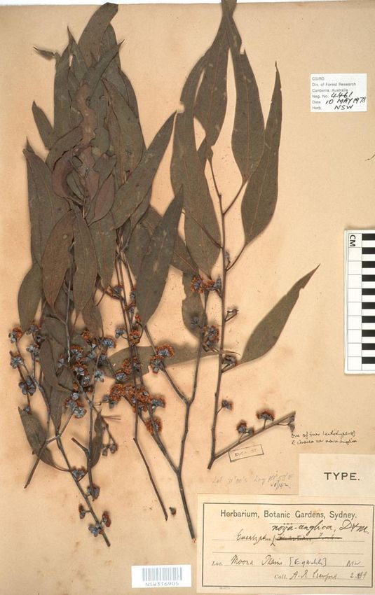
14 Property Planning Competition Manual Brookfield 2020species such as the Koala, Spotted-tailed quoll, woodland birds and Alpine copperhead. A fauna list for Brookfield can be found in Appendix 3. Endangered Ecological Communities An ecological community is a naturally occurring group of native plants, animals and other organisms living in a unique habitat. A healthy ecological community is vital for their survival. Ecological communities provide natural management of clean air and water, provide nutrients for the soil, protect against erosion and salinity, and provide a healthy environment for threatened species. An ecological community can be at risk of extinction. This can occur because of a significant reduction in its distribution across regions or a decline in ecological function. The decline can occur if there is a change in community structure or composition, disruption of ecological processes, invasion by exotic species, or habitat degradation or fragmentation (Office of Environment and Heritage 2018). Of the Endangered Ecological Communities found on the Northern Tablelands, the one of note in the vicinity of ‘Brookfield’ is New England Peppermint (Eucalyptus nova-anglica) Woodland on Basalts and Sediments in the New Eucalyptus nova-anglica Photo:PlantNET – Flora online England Bioregion. Brookfield does have New England Peppermint trees on the ridges, however as earlier stated, having the tree does not necessarily mean that the whole community is present. Management Actions Farmers can undertake simple actions to manage and increase biodiversity on their land, including: Manage Existing Bushland and Ecosystems • Fence to manage grazing • Control weeds • Control feral animals 15 Property Planning Competition Manual Brookfield 2020
•     Manage fire
   •     Make bushland patches bigger
   •     Increase the number of plant species

Manage Existing Paddock Trees
   •     Keep and protect paddock trees

Manage Grassland / Native Pasture
   •     Manage grazing
   •     Maintain high groundcover
   •     Increase species diversity

Revegetate
  • Create new bushland patches
  • Plant scattered trees
  • Create wildlife corridors
  • Plant shelterbelts or alley-farming
  • Protect, restore, enhance and increase riparian buffers
  • Consider farm forestry
  • House and shed plantings (provide habitat for fauna)
  • Create seed production areas (for use in revegetation work)
  • Create bug banks (dense planting of flowering shrubs among crops)
  • Roadside plantings (fill in gaps of vegetation near important roadside corridors)
  • Plant mid-paddock clumps for protection of stock and use by wildlife.

Key points
At the landscape level, each
individual property needs to
protect the ecosystem services
it can provide in order to
maintain a functioning
ecosystem. Issues such as
providing habitat, protecting
beneficial fauna and
maintaining healthy waterways
must be considered in the
broader landscape context.

                                                          Planting native vegetation

16 Property Planning Competition Manual Brookfield 2020
Land Capability
Farm planning is about designing a sustainable farming system that takes into account land
capability so the farm can be managed to reduce present, and prevent future, land
degradation. Your farm plan will identify landscape characteristics and help you plan to match
land use to land capability. Land capability is an essential part of mapping your farm’s
resources. A land capability map is a set of guidelines for how your property should be
managed sustainably which tells you which parts should be cropped, which parts should be
grazed and areas that are best left in their natural state. By identifying how to manage the land
sustainably within its land capability you are ensuring your management decisions will not
cause your land resource to deteriorate. Land capability is not determined by the current land
use but rather it is based on its potential for sustainable land use if developed.
The term land capability refers to “the ability of land to sustain a type of land use without
causing it permanent damage”. In New South Wales there are eight classes within the land
capability assessment system, and these are classified according to soil type, slope and
erosion risk. These factors influence how you manage your land and the production techniques
you use. Farming beyond the limitations of the land, by over-grazing or cultivating on
inappropriate areas, can leave soil vulnerable to erosion. It is important to identify the different
land classes on your property and manage them within their limitations. This will reduce the
risk of erosion occurring on your farm.
Table 1 and Figure 7 present the eight class system that was used to classify land on
Brookfield, and indicate how each may be best managed to maintain its productivity and
sustainability. Brookfield is mapped with land classes III, IV and VI (Map 3, Appendix 1).
Figure 7: Land capability classes
17 Property Planning Competition Manual Brookfield 2020Table 1: Land Capability classes
Land Class Soil conservation practices Brief description
No special soil conservation Usually flat land that is suitable for a wide variety of uses.
works or practices required When it is fertile it can be used for almost anything including
I fruit and vegetables, sugar cane, cereal crops and other
grain crops.
Soil conservation practices such Gently sloping land suitable for many agricultural uses. Good
II as strip cropping, minimum cropping land on fertile soils. Low erosion potential.
tillage and crop rotation
Structural soil conservation Sloping country that is likely to wash and erode when
III works required, conservation cultivated. The land is quite fertile and adequate for cropping
tillage techniques and crop as long as soil conservation practices such as contour banks
rotation are used.
Soil conservation practices such Good grazing country but not suitable for the practices listed
as pasture improvement, stock in I to III. Main limitations are slope, rockiness, soil fertility,
IV management, fertiliser and susceptibility to soil structure decline. Maintenance of
application and minimal good ground cover is essential.
cultivation for pasture
establishment and maintenance
As above, as well as absorption Not suitable for cultivation on a regular basis owing to slope
V banks, diversion banks and gradient, soil erosion, shallowness or rockiness, climate, or a
contour ripping combination of all of these factors. Soil erosion problems are
often severe.
Limitation of stock, aerial Comprises the less productive grazing lands that should not
VI spreading of seed and fertiliser. be cultivated because of soils, slope, wind or water erosion
May include some isolated hazard. Requires sound grazing management and pasture
structural earthworks. improvement.
Land best protected by green
VII timber or undisturbed ground Too fragile for grazing.
cover.
VIII Unsuitable for agricultural Cliffs, lakes or swamps etc. Not capable of sustaining
production agriculture.
18 Property Planning Competition Manual Brookfield 2020Land Management and Erosion Risk From the description of land classes on the previous page, there is a clear link between those classifications and the risk of erosion. All land classes of Class III and above are at some risk of erosion if land management practices are not tailored to work within their limitations. To decide what class, or classes, your farm fits into you need to have a good idea about the soil types on your farm. Soil boundaries may follow land class boundaries. However, different soil types can also occur within the one land class and are more prone to erosion and require different management. For this reason it is advisable to do some basic soil tests. Land management practices targeted at reducing erosion risk are generally also good for overall soil health. Maintaining or establishing well vegetated paddocks will lead to better soil structure, and plant water availability. These improvements will ultimately lead to better productivity, resulting in a win-win situation - reduced erosion and increased productivity. Key Points Using information on contours and soil, and Map 3 ‘Land Capability’, consider what land use enterprise options and management are best suited to this property. There are several different enterprises that could be run on Brookfield. Students should consider the best land use and discuss whether they would recommend the current land uses or others. It is more economical to manage productive land better, than it is to try and convert less productive land to a higher production standard. Less productive land can still be utilised to perform important functions within the property. Fencing to soil type or land capacity may make expenditure eligible for tax deduction in the year of construction. Soils Soil is the main resource upon which plant and animal production depends, so it is essential to understand the features that determine the ability of a soil to support such production, and to be resilient towards degradation. The soil types at Brookfield are predominantly traprock which are generally shallow with fertility being variable but more commonly fair to low. There are some black basalt areas indicated on the land capability map. Soil types on Brookfield Soil Pit 2019 Schools Property Planning Competition Definitions and Information for Soil Soil texture describes the relative proportions of sand (large particles), silt (small particles) and clay (tiny particles) in a soil. Texture indicates the ease with which a soil can be worked 19 Property Planning Competition Manual Brookfield 2020
and its capacity to hold water and nutrients. Texture also affects the ability of a soil to handle
machinery traffic, and its susceptibility to erosion.
Soil pH is a measure of the acidity or alkalinity of a soil. It is an important factor in determining
the availability of nutrients and trace elements to plants. At low pH for example, nutrients such
as Phosphorus become deficient, while others such as Aluminium become available in toxic
amounts.
Soil colour gives a good guide to the level of organic matter, degree of leaching and level of
drainage. Red and brown soils indicate good drainage and are usually found higher on ridges
and upper slopes. Yellow, grey and mottled soils are indicators of less well drained soils and
are usually found in lower areas and on drainage lines.
Soil structure refers to the arrangement of soil particles, the strength of the bonding between
them and the size and distribution of the pores throughout the soil. Structure plays an
important role in determining the ability of a soil to absorb and to hold water and air. Also, the
ease with which seedlings may emerge from and roots may penetrate the soil.
Soil fertility refers to the ability of a soil to provide a plant with the nutrients essential for
growth, and also the absence of toxic species.
The rate of infiltration of soil affects the possible amount of run-off and recharge to
groundwater.
Soil salinity refers to the presence of salt in the soil. A high salt level is toxic to plants, and
may cause poor pasture growth and reduced crop yield, and in extreme cases, bare patches of
unproductive land.
Organic matter helps bind soil together which maintains good structure and water holding
capacity. It acts as a mulch and encourages soil biota which assist in nutrient cycling.
Soil Erosion
Soil erosion occurs if land is managed beyond its capability. Management of soil erosion relies
on good land practices being adopted. In some cases remedial earthworks may be required,
however these need to be well planned as ground disturbance can often lead to greater
problems. It is imperative that they be used in conjunction with good land management
practices.
In areas subject to erosion, suitable control structures may include contour banks, levees,
pasture belts and waterways, gully filling and gully control weirs and dams. Structures that
control water erosion are designed to slow water down before it can cause erosion. It may be
channelled via waterways and contours into small gullies and creek lines. In some cases the
water is diverted into dams to store and slow water. Water directed into dams can add to the
farm water supply.
Any erosion control program that involves diversion of runoff must provide for safe disposal of
that water. When considering the disposal of runoff water it is important to identify the flow-
lines and point or points at which water naturally leaves the property.

20 Property Planning Competition Manual Brookfield 2020
Key Points
•   Consider the possibility of erosion by looking at information on land capability and soil type.
    If you determine contour banks are necessary, indicate the flow direction of the run-off water
    along the contour banks.
•    There is a legal obligation to ensure that there is no diversion of run-off from one exit point
    to another. Once these exit points are known it is then possible to design and locate a
    system of erosion earthworks.
•   The modification of catchments through soil erosion control works that alters the way water
    is delivered to watercourses may affect stream behaviour and stability. When undertaking
    soil erosion works the impact on downstream areas should be considered.

                Figure 9: Potential impacts of management on a riparian zone (copyright Jen Rae, The Riparian Project
                                                http://theriparianproject.com.au/about )

21 Property Planning Competition Manual Brookfield 2020
Water Quality
Clarence River Catchment
A catchment is an area of land catching rainfall that flows into a creek, river, wetland or the
ocean. Hills or ridges separate each catchment and direct the flow of water into different
waterways. Within catchments, there are natural features such as native vegetation, water,
rocks and soils. Catchments are also the places where people live, work and play. Human use
in catchments can have an impact on water quality. This will affect the availability of water for a
variety of uses.
Catchments occur at a variety of scales from very large catchments such as the Murray–
Darling Basin to local creeks and streams that may only flow occasionally. The
interconnectedness of catchments means that changes in water quality in small local
catchments will impact on larger creeks and rivers downstream. Catchments require
management to be sustainable for future generations. Sustainable management will maintain
and improve the quality of natural resources within a catchment and meet the needs of the
community, ecosystems and the environment.
Brookfield is situated in the head waters of the Clarence River catchment. In the upper reaches
of the catchment, such as mountain regions or foothills, rivers are usually fast flowing. This
means they have the energy to carry large pieces of rock and gravel eroded from stream beds
and banks. Vegetation along the banks (riparian) provides a buffer from overland flow,
reducing the input of sediment and nutrients. The upper parts of a river system are very
important to the health of the entire river because this is the source of much of the food carried
downstream (Figure 8). Dams and weirs impede the distribution of food and seeds and the
migration of aquatic animals, as well as altering flow rates and flood frequencies. Overhanging
vegetation provides much of the food (in the form of leaves, fruits, seeds, twigs and bark)
required by stream organisms such as macro invertebrate ‘shredders’, which convert coarse
material to finer fragments. These macro invertebrates (water bugs) are adapted to fast moving
water, e.g. by having streamlined bodies.
Healthy Catchments and Rivers
A healthy catchment is one that is sustainable and able to meet the needs of the community,
ecosystems and the environment. The health of a waterway can be measured by
characteristics such as:
• Water quality measured by physical, chemical and biological parameters.
• Healthy ecosystems with a high biodiversity. This includes both aquatic and terrestrial
ecosystems, especially along riverbanks.
• The resilience or capacity of the ecosystem to maintain its structure and function in the
presence of stress. This may be caused by natural factors such as floods or human-
induced change.
Land use is a key factor determining the health of waterways (Figure 9). Human activity can
impact on river health by influencing the interactions between natural resources (land, water,
vegetation and soils) and between aquatic and terrestrial ecosystems. For example,
22 Property Planning Competition Manual Brookfield 2020agricultural land uses such as general crops and pastures can lead to the removal of
groundcover which can cause erosion and rising water tables. Runoff can pollute water with
nutrients, sediments and pesticides. Poor irrigation and land use can lead to salinity problems.
Some of the water quality tests that might be used to assess whether water quality has been
impacted include:
• Presence of macro invertebrates
• Presence of algae
• Stream vegetation overhang
• Dissolved oxygen
• Turbidity
• pH
• Phosphates
• Salinity (EC)
• Habitat assessments.
Figure 8: Cross-section of a healthy stream
Water on Farms
It is important to maintain good water quality on farms:
• For stock watering
• For the health of aquatic animals
• Downstream users – what kind of water is heading to
neighbouring properties?
• It can tell us a bit about the catchment, where the water is
coming from and any problems that we can address by
planning.
Stock need to drink water that has low turbidity, low salinity and
neutral pH. For example, consider the effect of pH on stock:
water for domestic and stock use should be in the pH range of 6.5
to 8.5. If the pH is highly acidic (less than 5.5), acidosis and
reduced feed intake may occur. Highly alkaline water (over 9) Water bore pressure gauge
may cause digestive upsets and diarrhoea, lower feed conversion
efficiency and reduce intake of water and feed.
23 Property Planning Competition Manual Brookfield 2020Table 2: Effect of Saline Water on Stock
Livestock No adverse effects on Animals may have initial Loss of production
animals expected reluctance to drink or and a decline in
there may be some animal condition and
diarrhoea, but stock health would be
should adapt without expected. Stock may
loss of production tolerate these levels for
short periods if
introduced gradually
EC in μS/cm EC in μS/cm EC in μS/cm EC in μS/cm
Poultry 0 to 3100 3100 to 4700 4700 to 6300
Beef cattle 0 to 6300 6300 to 7800 7800 to 15,600
Dairy cattle 0 to 3900 3900 to 6300 6300 to 10,900
Sheep 0 to 7800 7800 to 15,600 15,600 to 20,300*
Horses 0 to 6300 6300 to 9400 9400 to 10,900
Pigs 0 to 6300 6300 to 9400 9400 to 12,500
Watering Systems
In order to maintain good water quality for the
benefit of stock and the environment, it is
important to design a watering system to
support this. Watering systems can include a
reticulated system of pipes, pumps, tanks and
troughs, or on some farms, stock access
waterways directly to drink water. Stock access
to waterways can impact on water quality by
stock ‘pugging’ in the muddy banks, causing
them to become boggy and the water to become Solar powered water bore
contaminated with suspended soil and faeces.
This may cause stock to reject the water and impact on water quality downstream. Also,
animals in weak condition may become bogged and die. The reticulated watering system
avoids these problems by keeping stock out of waterways.
Key Points
In order to protect water quality, riparian vegetation should not be removed and livestock are
best watered through a reticulated water system which prevents them from damaging
watercourses and dams. Retaining vegetation on property also helps to prevent erosion and
salinity problems. Stock need clean, fresh water in order to maintain good health and put on
condition.
24 Property Planning Competition Manual Brookfield 2020Salinity What Causes Salinity? Changes in land use since European settlement from woodland to grazing and cropping, have changed the hydrology in some areas of the Northern Tablelands. Trees and deep-rooted perennial pastures have been replaced with more shallow rooted species. This means that moisture found at depth cannot be pumped out by evapo-transpiration. This leads to an increase in the excess water in the soil across the landscape and causes a rise in the water table which, in turn, causes salts to rise through evaporation and accumulate in the soil surface. Salt toxicity impacts plant growth and cell functions. Salinity in the subsoil above a scalded site will also limit pasture production as roots will not penetrate salty soil layers. This also results in a reduced capacity for plant’s roots to extract water at depth. Site History Salinity is not currently a problem on Brookfield, however it is still important to consider in preparing a property plan in this region. Indicator Plants Indicator plants are a group of species that provide us with an indication of the presence of salt in the soil and a shallow water table. These species are known to tolerate high levels of salt. Table 3 identifies those salinity indicator plants which may be found at saline sites. Some of these plants may also prefer wet conditions, so it is important to check whether salt incursion is occurring. Table 3: Indicator Plants Common name Scientific name Salt tolerance (Low/medium/high) Sea barley grass Hordedeum marinum High Rhodes grass Chloris gayana High Native panic Panicum buncei High Couch grass Cynodon dactylon Medium Swamp fox tail Pennisetum sp. Medium (prefer damp conditions) Wallaby grass Rytidosperma sp. Low Rats tail fescue Sporobolis creber Low Soil Salinity Test Results Table 4 provides guidelines for classifying the level of salinity in soils. Table 5 indicates the level of salinity that various crops and plants are able to tolerate. 25 Property Planning Competition Manual Brookfield 2020
Table 4: Soil salinity classes

 Class                         ECe dS/m                   Comments

 Non-saline                    16                        Only a few very tolerant crops yield satisfactorily

Table 5: Tolerance levels for different crops and plants

 Crop                               ECe dS/m                      Plant                          ECe dS/m

 Lucerne                            2                             Green Panic                    5.6

 Sunflowers                         5.5                           Couch grass                    6.9

 Wheat                              6                             Barley                         8

                                                                  Salt Bush                      12

Key Points
Preventing salinity problems is much easier and cheaper than trying to fix them. Maintaining
deep rooted perennial vegetation and monitoring indicator plants are good ways to avoid and
monitor salinity in the environment.

26 Property Planning Competition Manual Brookfield 2020
Biosecurity
What is Biosecurity?
Biosecurity is the set of measures for protecting a population at the national, regional and farm
level. The object is to protect the economy, environment and community from the negative
impacts associated with diseases, pests, weeds, toxins and chemical residues.
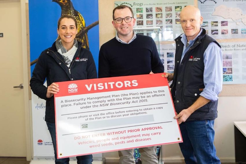
Photo: The Land.com.au; Elli Sinclair biosecurity officer and Paul Hutchings, General Manager Northern
Tablelands Local Land Services, with NSW Minister for Agriculture, Adam Marshall displaying new
biosecurity signage.
Farm Biosecurity
Farm biosecurity is defined as reducing the risks to a farm business by limiting the likelihood of
introducing or spreading animal diseases, pests, weeds etc. Most biosecurity measures are
very simple and low-cost and should be part of regular management routine. Such biosecurity
practices will go a long way to securing a farm and its future.
The benefits of implementing biosecurity practices include:
• Greater productivity on farm – better livestock and plant health generally leads to higher
productivity
• Reduced risks on farm – less disease, pests and weeds entering the property and
requiring action
• Early detection and management of any pest, weed or disease – catch the problem before
it takes a hold
• Reduced costs if there is an outbreak of disease, weeds or pests – faster, easier and
cheaper eradication and, in some cases, quarantine.
27 Property Planning Competition Manual Brookfield 2020Priority Areas for Farm Biosecurity
The key areas that farm biosecurity focuses on to reduce risk include:
• New livestock (introducing livestock from other properties onto a farm)
• Purchasing and storing feed, bedding and water
• Restricted animal material and swill feeding
• Moving animals off your property
• Taking animals to shows and sales
• Animal husbandry (livestock monitoring, drenching, vaccinating)
• Fences (to prevent straying stock)
• Chemical usage, and
• General farm hygiene and maintenance (Animal Health Australia 2012b).
Livestock Diseases
On-farm biosecurity is about managing risks to meet the following goals:
• To prevent the introduction of infectious diseases to grazing livestock production properties
• To prevent the spread of diseases from an infected property to an uninfected property.
Most disease threats can be controlled before animals enter the property by putting in place an
effective biosecurity plan that:
• only allows healthy stock through the farm
gate
• Includes a period of on-farm quarantine
for all arrivals to monitor and confirm their
health status in isolation from your own
stock, and
• Includes effective vaccination or
preventive treatments against diseases
already known to be on the property.
Disease threats relevant to Brookfield include:
• Pestivirus Photo: art4agriculutre.com
• Johne’s Disease
• Leptospirosis
• Vibriosis (genital camplyobacteriosis).
More information is available on various DPI Primefacts or, importantly, information for specific
disease problems can be obtained from Local Land Services District Veterinarians or
Biosecurity staff.
Toxins and Chemical Residues
Chemical residues are chemicals that are applied to crops, animals, water or soil that leave
residues which break down over time. Common residues include:
28 Property Planning Competition Manual Brookfield 2020• banned organochlorines that are persistent in soils
• antibiotics and drenches
• pesticides and external parasite products
• heavy metals such as Lead or Cadmium
• other agricultural chemicals.
Residues need to be kept out of the food chain by:
• carrying out on-farm investigations to identify sources of residues
• eliminating the source of the residue or mitigating its effects
• investigating residue detections reported from abattoirs
• using tracing systems such as National Livestock Identification Scheme (NLIS) to identify
the source of a contamination
• following withholding periods on chemical labels.
Certification that livestock are free of disease and residues is essential for continued and
competitive access to domestic and international livestock markets.
Pest Animals
In Australia, pest animals have major economic, environmental and social impacts. Many pest
animals cause significant damage to crops and seriously affect Australia’s livestock industries
by preying on stock and competing for pasture. Pest animals also cause severe land
degradation by promoting soil erosion, stream turbidity and the spread of weeds. Competition,
habitat destruction and predation by pest animals threaten the survival of many of Australia’s
native plants and animals (Department of Environment Water Heritage and the Arts 2009a).
Australian private and public landowners and managers spend considerable time and money
addressing the impacts of pest animals. For example, it has been estimated that eleven of
Australia’s major pest animals (wild populations of foxes, pigs, rabbits, mice, goats, carp, dogs,
cane toads, camels, cats and horses) have negative impacts in Australia valued at $797 million
per year (Centre for Invasive Species Solutions, 2017).
29 Property Planning Competition Manual Brookfield 2020The following species are identified as priority pest animals in the Northern Tablelands region: Wild rabbits (Oryctolagus cuniculus) Wild rabbits compete with native wildlife, damage vegetation and degrade the land. They ringbark trees and shrubs, and prevent regeneration by eating seeds and seedlings. Their impact often increases during drought and immediately after fire, when food is scarce and they eat whatever they can. Wild rabbits have contributed to the decline in numbers of many native plants and animals (Australian Government 2004a). Wild dogs (Canis familiaris) In NSW, the term ‘Wild Dog’ refers to all wild living dogs: dingoes, feral domestic dogs and the hybrid descendants of these. They can have a significant impact on agricultural production and farm profitability due to their attacks on livestock and domestic pets. They also attack native wildlife which can have detrimental impacts on populations, especially for threatened and endangered species. Feral pigs (Sus scrofa) Feral pigs are environmental and agricultural pests. They cause damage to the environment through wallowing, rooting for food and selective feeding. They destroy habitat for native plants and animals and spread environmental weeds. Feral pigs destroy crops and pasture and they could spread exotic diseases should there be an outbreak (Australian Government 2004b). Feral pigs will eat anything from small animals to ground nesting birds, their eggs and chicks. They are responsible for the degradation of wetlands, cause erosion, disturb rainforest floors, dig up root systems and interfere with the regenerative cycle of native vegetation. Feral pigs can carry infectious zoonotic diseases (diseases naturally transmitted from animals to people) including brucellosis, leptospirosis and Q Fever. 30 Property Planning Competition Manual Brookfield 2020
You can also read