DRAFT FOR REVIEW - Town of Walpole Open Space and Recreation Plan - Walpole MA
←
→
Page content transcription
If your browser does not render page correctly, please read the page content below
DRAFT FOR REVIEW

Town of Walpole
Open Space and Recreation Plan
                        September 2020
The Metropolitan Area Planning Council
(MAPC) prepared this plan on behalf of the
Town of Walpole in close coordination with
Walpole staff and leadership.

Funding for this plan was made possible
through a grant made to the Town of Walpole
from the Massachusetts Office of Energy and
Environmental Affairs. Additional funding
was provided from Planning for MetroFuture
Technical Assistance (PMTA) from the
Metropolitan Area Planning Council.

Cover Image: Adams Farm photo by MAPC

Town of Walpole                               2         Open Space and Recreation Plan

                                     DRAFT FOR REVIEW
Contents

Section 1: Plan Summary				     page 05

Section 2: Introduction					         07

Section 3: Community Setting			      11

Section 4: Environmental Inventory and Analysis        25

Section 5: Inventory of Conservation and               39
Recreation Lands

Section 6: Community Vision				                        53

Section 7: Analysis of Needs				                       55

Section 8: Goals and Objectives			                     63

Section 9: Seven-Year Action Plan			                   67

Appendix
Section A: Public Comments				                         85

Section B: Survey Results		                            XX

Section C: ADA Accessibility Self-Evaluation
			                                                    XX

Town of Walpole                                   3         Open Space and Recreation Plan

                                       DRAFT FOR REVIEW
Bird Pond
                                                     Image: MAPC
Town of Walpole          4           Open Space and Recreation Plan

                  DRAFT FOR REVIEW
Section 1: Plan Summary
The 2020 Town of Walpole Open Space and                resources and as a foundation for the Seven-
Recreation Plan (OSRP) has been prepared               Year Action Plan of the OSRP. The Seven-
to guide Town Staff, committees, boards,               Year Action Plan provides detailed steps for
and commissions working to support open                achieving the goals outlined below. Once
space, conservation, and recreation in the             approved by the Massachusetts Executive
Walpole. The plan provides an update to                Office of Energy and Environmental Affairs,
the previous Open Space and Recreation                 the OSRP will open funding opportunities for
Plan prepared by the Town in 2011. A Core              the town related to open space and recreation.
Group comprised of town staff and leadership           Throughout this process the Walpole
guided the development of this plan. The               community has confirmed the importance of
process to develop the plan and the writing of         open space and recreation to the town. The
the plan was facilitated by the Metropolitan           Community Survey received 376 responses
Area Planning Council (MAPC). MAPC is the              and reaffirmed community values around
regional planning agency serving the 101               open space. 77% of respondents strongly
cities and towns of Metropolitan Boston. During        agree that preserving Walpole’s open space
this process, MAPC facilitated two public              and natural areas is important to them. The
forums, coordinated Core Group meetings,               importance of conservation was underlined by
met with staff from the Town of Walpole,               74% of respondents strongly agreeing that
and completed a community survey. All of               Walpole needs to proactively preserve what
these activities have been used to understand          open space is left. Indicating some room for
the goals and objectives of the community in           improvement, 65% of respondents strongly
regard to open space and recreation and                agree that Walpole’s existing open space and
each source of input has contributed to the            recreational amenities contribute positively to
content of this Open Space and Recreation              overall quality of life. Defining where some
Plan.                                                  of that improvement may occur, 65% of the
The Town of Walpole enjoys a great variety             respondents strongly agree that Walpole
of open space, conservation and recreation             needs to proactively plan for the recreational
resources. The resources include scenic ponds,         needs of its residents.
town forest, fields and playgrounds, and trail         A Vision Statement regarding Walpole’s open
connections, such as the regional Bay Circuit          space and recreation resources has been
Trail. One of the most important challenges            prepared through this process. That Vision
highlighted by the community survey is not the         Statement is as follows:
lack of resources, but the lack of knowledge           Vision Statement
about the resources available. Survey                  Walpole’s vision for Open Space and
respondents reported that not knowing about            Recreation is a Town with a green open
resource locations or access to trails or other        space network with walking and bike trails
facilities were the biggest impediments to using       that connect a series of recreational fields
Walpole’s open space amenities. An inventory           and other community amenities, as well as
of all resources is included in this Open Space        provide access to natural areas and the town’s
and Recreation Plan. The inventory serves              abundant ponds.
both as a way to share knowledge about the             The vision includes an abundance of clean

Town of Walpole                                    5                   Open Space and Recreation Plan

                                       DRAFT FOR REVIEW
drinking water from our Town wells and other           General Goal
groundwater sources.                                   “To preserve and enhance the overall quality
The vision includes an abundance of playing            of the natural and cultural environment within
fields for youth and adults where overuse does         the Town of Walpole while providing a
not exist.                                             well maintained system of parks, recreation
The vision includes clean water resources              facilities and conservation lands, trails, town
(rivers, ponds, streams, wetlands, and aquifers)       forest, ponds and other lands subject to land
for today and the future; where our ponds are          restrictions that meet the diverse needs of the
clear and free of nuisance aquatic vegetation          community and contribute to making Walpole
and available for fishing, boating, skating and        a healthier community.”
other passive recreational uses.
This vision includes walking trails and canoe          Conservation Goals
launches along the Neponset River; trails for          • Goal 1: Protect and improve the quality of
dog walking and bridge watching; and habitat           Walpole’s surface and ground water.
for wildlife.                                          • Goal 2: Protect and encourage preservation
This vision includes a Walpole with a mixture          of the Town’s natural and cultural resources.
of the new and the old; where our most                 • Goal 3: Maintain and manage existing Town
significant natural, historic, and cultural            open space land.
resources are saved for future generations.
The Town of Walpole has articulated goals              Recreation Goals
that define the Open Space and Recreation              • Goal 4: Continue to expand recreational
Plan. These goals are detailed with objectives         facilities to provide a wide variety of active
and each objective is associated with actions          recreation opportunities to encourage a
that can be undertaken to advance the goals            healthy and active community.
and objective. The OSRP goals begin with               • Goal 5: Maintain and manage existing
an overarching General Goal and then have              recreation facilities.
been categorized as Conservation Goals or
Recreation Goals including:

Town of Walpole                                    6                    Open Space and Recreation Plan

                                       DRAFT FOR REVIEW
Section 2: Introduction
Statement of Purpose                                  of Conservation Services (DCS). The previous
The Town of Walpole is a spirited community           2011 Open Space and Recreation Plan did
with a small town feel and community-oriented         not complete this process leaving additional
values. Walpole like many New England                 grant resources unavailable to the town. This
communities has changed over time adapting            current plan will be used to complete that
as changes in industrial and commercial               process of review and validation with DCS.
needs, transportation needs, and residential
needs evolved. However, parts of Walpole              What is open space?
have changed little. The new and the old, the         Open space is undeveloped land that is either
contemporary and the historic, are parts of           left in its natural state or improved for use for
Walpole’s charm and form the context for this         recreation or agriculture. This land is often
Open Space and Recreation Plan.                       accessible to the public and usually without
Walpole’s resources are diverse and so are            buildings or structures. Open space is typically
its needs. Walpole has always sought to               divided into two categories – conservation
balance the need to acquire and preserve its          lands and recreation resources.
natural resources with its needs to be fiscally       Conservation land is usually left in its natural
responsible. The 2020 Open Space and                  state and it often, but not always, open to
Recreation Plan seeks to maintain this balance        the public. Conservation lands may include
and respond to the needs of the Town by               animal and plant habitats, water resources and
preserving its historic, cultural, and natural        aquifer protection, and other natural, historical
treasures, by maintaining open space areas            or cultural features.
already owned, by protecting groundwater
for drinking water, and by thinking ahead to          Recreation resources support activity. Active
provide opportunities for residents to enjoy          recreation land supports activities for team
both open space areas and recreational                sports, tennis, swimming, golf, or other
facilities in the future.                             competitive sports taking place in or on
                                                      developed facilities. Passive recreation is
Why was this plan written?                            defined as any activity that can be performed
The 2020 Open Space and Recreation Plan               outdoors with a minimum disturbance to an
was undertaken to update and renew the                area’s natural resources. Examples of passive
Town’s previous 2011 Open Space and                   recreation include hiking, picnicking, canoeing,
Recreation Plan. While many aspects of the            ice-skating, cross country skiing, and informal
previous plan remain relevant and valid, this         sports on an open field. Conservation land
current plan updated the progress made                may offer passive recreation opportunities.
against actions previously identified, updated        This Open Space and Recreation Plan defines
the plan with current data and analysis,              an inventory of both active and passive
and reassessed the community’s priorities.            recreation areas, as well as other types of
Another important aspect of this plan is to           open spaces that serve conservation purposes
produce a document that will be formally              or that protect other historic or cultural
approved by the Executive Office of Energy            features. An inventory of the Walpole open
and Environmental Affairs (EOEEA) Division            space resources is documented in Section 5.

Town of Walpole                                   7                    Open Space and Recreation Plan

                                       DRAFT FOR REVIEW
Planning Process and Community                       • Brendan Croak, Recreation Director
Participation                                        • Drew Hand, Superintendent of Highway,
The Town of Walpole supported the                    DPW
development of this plan through the guidance        • Landis Hershey, Conservation Agent
and supervision of a Core Group comprised of         • Sara Khatib, Planning Board
town staff and leadership. The overall process       • Jim Johnson, Town Administrator
and Core Group meetings were managed                 • Glenn Maffei, Board of Sewer and Water
and coordinated by Landis Hershey, the Town’s        Commissioners and Trails Committee
Conservation Agent. During the process, the          • Kerri McManama, Director Council on Aging
Core Group met regularly with MAPC staff             • Justin Monta, Superintendent Parks and
to review and contribute to elements of the          Cemeteries, Tree Warden
plan and to assist with community engagement.        • Gary Riggott, Trails Committee
All meetings were publicly posted. The Core          • Patrick Shields, Assistant Town Administrator
Group consisted of the following members (in         • Jack Wiley, Chair Conservation Commission
alphabetical order by last name):                    and Adams Farm Committee
                                                     • Michael Yanovitch, Building Inspector

                                                                                   Memorial Pond
                                                                                    Image: MAPC

Town of Walpole                                  8                    Open Space and Recreation Plan

                                      DRAFT FOR REVIEW
The Metropolitan Area Planning Council                 strategies that promote positive impacts in EJ
(MAPC) facilitated the process. MAPC                   communities. For example, EOEEA has now
provided project management, technical                 amended the LAND grant program regulations
analysis, and community engagement                     to incorporate environmental justice in the
assistance to advance the planning process and         award scoring system. Similarly, the Riverways
prepare the plan document. The preparation             and the Massachusetts Environmental Trust
of the plan was made possible by grants from           will work with EOEEA to develop systems
the Commonwealth of Massachusetts Executive            for incorporating environmental justice as a
Office of Energy and Environmental Affairs             criterion for awarding grants. The EOEEA also
and MAPC Technical Assistance.                         has determined to target its resources to more
An Open Space and Recreation Survey                    effectively create, restore, and maintain open
was developed and posted on the Town of                spaces located in neighborhoods where EJ
Walpole website and was available for over             populations reside.
a month. The survey was well circulated and
received 376 responses from community                  Environmental Justice Populations in
participants.                                          Massachusetts are determined by the following
                                                       criteria:
Enhanced Outreach and Public Participation             • Households earn 65% or less of the
The Executive Office of Energy and                     statewide household median income; or
Environmental Affairs (EOEEA) and other                • 25% or more of the residents are minority;
state agencies have been implementing an               or
Environmental Justice (EJ) Policy since 2002 to        • 25% or more of the residents are foreign-
help ensure that all Massachusetts residents           born; or
experience equal protection and meaningful             • 25% or more of the residents are lacking
involvement with respect to the development,           English language proficiency
implementation, and enforcement of
environmental laws, regulations and policies           By these criteria, 137 municipalities in the
and the equitable distribution of environmental        Commonwealth of Massachusetts include an
benefits. This policy was instituted because the       Environmental Justice Population, as identified
Commonwealth realized that low to moderate             through analysis by MassGIS. The Town of
income residents in densely populated older            Walpole is not one of these communities
industrial areas often lack open space and             and does not include an Environmental
recreation resources and may live near old,            Justice Population. The most recent analysis
abandoned, and/or contaminated sites                   completed by MassGIS (Bureau of Geographic
that can pose risks to public health and the           Information), using data from the 2010 Census
environment.                                           and ACS 2010 5-year Estimates, identifies no
                                                       block groups within Walpole that meet one
Environmental justice is an integral                   or more of the environmental justice criteria,
consideration in all EEA programs, to the              including foreign-born, minority population,
extent applicable and allowable by law. The            and income. A map of the Environmental Justice
Environmental Justice Executive Order No.              block groups in Walpole and further discussion
552 requires Secretariats to take action in            of EJ populations in neighboring municipalities
promoting environmental justice. The Executive         is included in Section 3: Community Setting.
Order requires new environmental justice
Town of Walpole                                    9                   Open Space and Recreation Plan

                                        DRAFT FOR REVIEW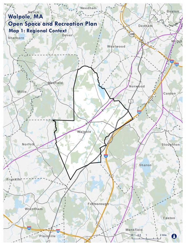
Walpole Center Pool
                                                    Image: MAPC
Town of Walpole          10          Open Space and Recreation Plan

                  DRAFT FOR REVIEW
Section 3: Community Setting
Regional Context also home to a significant number of jobs that
The Town of Walpole is located in Boston are clustered along the Route 1 corridor. In
metropolitan area, southwest of Boston, addition to these major centers of activity,
in Norfolk County. The town is about 19 the Town has a pattern of dispersed village
miles south of Boston and 26 miles north centers including East Walpole, South Walpole,
of Providence, Rhode Island. The Town of and Plimptonville that all contribute to the
Walpole shares municipal boundaries with the character, services, and amenities of the town.
towns of Dover, Westwood, Norwood, Sharon,
Foxborough, Norfolk, and Medfield. Walpole Aside from these features, the remainder of
is among the largest of these communities by the town is a mix of a variety of residential
size of population. neighborhoods and areas that retain a rural
character. The residential neighborhoods are
Interstate 95 and U.S. Route 1, both of which densest near Town Center and East Walpole.
are located near the eastern boundary of The northern part of the town remains the
the town, provide regional access to the town. most rural in character due to the Town-owned
State Routes 1A and 27 provide more direct Adams Farm property and the land associated
local access to the town. State Route 1A bisects with the Norfolk County Agricultural High
the town roughly from north to south. State School.
Route 27 bisects the town roughly from east to
west. The two state routes meet at the center Walpole is host to a major regional resource
of the municipality in the Town Center. The in the Norfolk County Agricultural High School.
Franklin Commuter Rail Line passes through It enrolls over 500 students from the 28 towns
Walpole to provide regional rail access with in Norfolk County and is situated on 365
a station in Town Center and Plimptonville, a acres in Walpole. Walpole is also host to a
station north of Town Center. Both stations are state correctional facility, the Massachusetts
also part of the Foxboro Commuter Rail Line Correctional Institution Cedar Junction. It is a
Pilot. A CSX line that runs perpendicular to the maximum-security reception and diagnostic
commuter rail line provides regional freight center with a medium-security component and
access. large open space parcel.
Walpole’s Town Center is a regional hub Regional Planning Context
of economic activity that offers amenities Walpole is one of the 101 cities and towns
and services to the town and surrounding located within the greater Boston metropolitan
communities. The Town Center is also the region. The Metropolitan Area Planning Council
center of municipal facilities and services with (MAPC), the regional planning agency, serves
the Town Hall, Senior Center, Public Safety, the region. Each municipality in the region
and Library. Walpole also has significant belongs to one of eight subregions. Walpole
commercial and industrial development is a member of the Three Rivers Interlocal
along Route 1 that serves the residents of Council (TRIC). Council membership consists
the town and surrounding communities. These of community representatives, gubernatorial
commercial and industrial establishments are appointees, and city and state agencies
Town of Walpole 11 Open Space and Recreation Plan
DRAFT FOR REVIEWthat collaborate around issues of regional • Goal 61 – Water resources will be carefully
importance. MAPC’s professional planners budgeted and sustainably managed so that
provide technical assistance to member clean water is available for appropriate uses
communities through the development of and development.
comprehensive plans and recommendations in • Goal 62 – The region’s rivers, streams, lakes,
areas of land use, transportation, economic and ponds will have sufficient clean water to
development, public health, environment, and support healthy populations of native fish and
more. other species, as well as recreational uses.
• Goal 63 – The ecological condition of
MAPC is currently leading a regional planning wetlands will improve, and fewer wetlands will
process called MetroCommon 2050 that is an be lost to development.
update to the regional plan. The current plan, • Goal 64 – The region will retain its
MetroFuture, was adopted in 2008 and is used biodiversity and will have healthy populations
by MAPC and municipalities to coordinate of native plants and animals, and fewer
local planning efforts. Once completed and invasive species.
adopted the new regional plan will be used • Goal 65 – A robust network of protected
for this type of coordination. MetroFuture open spaces, farms, parks, and greenways will
guides the work of MAPC agency-wide and provide wildlife habitat, ecological benefits,
every project MAPC undertakes works towards recreational opportunities, and scenic beauty.
reaching the goals defined in the plan. Many
of the 65 goals defined in MetroFuture are In addition to regional planning documents
applicable to the Walpole Open Space and from MAPC, neighboring municipalities have
Recreation Plan, including: local plans that represent opportunities for
municipal collaboration. In the immediate
• Goal 7 – Cities, towns, and neighborhoods vicinity of Walpole, the town of Norfolk has
will retain their sense of uniqueness and recently completed an Open Space and
community character. Recreation Plan. A full listing of neighboring
• Goal 8 – Historic resources will be preserved municipalities Open Space and Recreation
and enhanced. Plans and the date of the most recently
• Goal 9 – The region’s landscape will retain completed plan include:
its distinctive green spaces and working farms. • Town of Dover (2011)
• Goal 11 – The region will be prepared for • Town of Westwood (2019)
and resilient to natural disasters and climate • Town of Norwood (2020)
change. • Town of Sharon (2010)
• Goal 23 – All neighborhoods will have • Town of Foxborough (2011, an update is
access to safe and well-maintained parks, underway)
community gardens, and appropriate play • Town of Norfolk (2017)
spaces for children and youth. • Town of Medfield (2016)
• Goal 25 – Most residents will build regular
physical activity into their daily lives. History of Community
• Goal 42 – The region’s agricultural economy The history of Walpole began long before
will grow through a focus on sustainable records of any type were being kept. The
farming and by bringing more locally next section on geology points to the long
produced foods to the market. history of the land and the natural resources
Town of Walpole 12 Open Space and Recreation Plan
DRAFT FOR REVIEWTown of Walpole 13 Open Space and Recreation Plan
DRAFT FOR REVIEWthat this plan is intended to steward. The “the Old Post Road” where Pleasant Street
histories of people on that land began with passes through East Walpole on through to
the indigenous populations of the area. The Foxborough and Attleboro. The other trail
area that is now called Walpole was originally passing through Walpole Center was “the
territory claimed by the Neponset Native Old Saw Mill Road” it followed the Medfield
American tribe. The rocky uplands and cedar Trail from Dedham through Westwood to
swamps provided a natural buffer between North Street and Main Street to the Walpole
the Neponset tribes to the east and the Common, from there it went from West Street
Wampanoag and Narragansett tribes to the and then to King Philip’s Road to Wrentham
south and west. Artifacts from the activities of (History of Walpole, Maude Greaves).
these indigenous populations have been found
near Plimptonville and Hilltop Farm and a During the Federal Period (1775-1830),
native village site has been identified along the small mills developed into established
the river in South Walpole (Town of Walpole, industries, producing cotton, wool, paper and
1987). agricultural implements. The Town Center
continued to develop and villages were
The first European settlers arrived between created in South Walpole and East Walpole.
1660 and 1670 to live on the high ground The Town continued to grow with the region.
between the Neponset River and Spring Brook. Following this period, railroads developed,
They harvested cedar from the cedar swamps, commercial and industrial activities grew, and
or were subsistence farmers. During the the population of the town grew. Mary Bird
Colonial Period (1676-1776) the population started a small library in East Walpole in
increased to nearly 1,000 people, most of 1876. The Town Hall was completed in 1881
who were engaged in agriculture during the at a cost of $30,000 dollars. In 1893, the
summer and lumbering during the winter. Mills town authorized to supply its inhabitants with
were built on the Neponset and other streams waster, using the water of Spring Brook, Trap
to process local products. Forges and smelters Hole Brook, Mill Brook, and artesian or driven
were also constructed to process bog iron. wells (History of Walpole, Maude Greaves).
Several two-story central chimney houses and Trolleys at the turn of the century fostered
Cape Cod cottages that were built during suburban development that continued into
this period still remain in the town. A lime kiln the remainder of the twentieth century with
from this era has also been excavated in West the popularization of the automobile and
Walpole (Town of Walpole, 1987). development of a regional highway network
that offers convenient connections to Walpole
In 1724 the town was set off from Dedham afforded by Interstate 95 and Route 1 (Town
and named for Sir Robert Walpole. Walpole of Walpole, 1987).
was an eminent English statesman and political
leader. The first town meeting was held in Demographic Context
Walpole on December 24, 1724. At this time, Population Trends
the town had two prominent trails that were According to the 2010 U.S. Census, the
traveled by foot or horseback and used in residential population of Walpole was
carting lumber from the cedar swamps to 24,070. The population of the town has
the old sawmill. The paths of the trails are seen continued growth over most of the past
distinguished to this day and were known as century. From 1920 to 1970 the town grew
Town of Walpole 14 Open Space and Recreation Plan
DRAFT FOR REVIEWrapidly with the most substantial growth in the The Status Quo projections show that
1950’s when the population grew 54.44% or Walpole’s population is to remain relatively
nearly 5,000 residents in a decade. Between stable through 2030, increasing by 2.9
1950 and 1970, the population of the town percent. The Stronger Region projections show
doubled. The population has continued to grow a 7% population increase between 2010 and
in more recent decades, but not at that peak 2030 with a projected population in 2030
pace. Total town population increased by of 26,333. In addition to projections by total
nearly 20% between 1990 and 2010. population, the projections are also made
by the measure of a household. A household
The analysis of population trends in Walpole consists of all the people who occupy a housing
was developed for the recently completed unit. Household numbers increased over 30%
update to the town’s Housing Production Plan between 1990 and 2010. The Stronger Region
in 2019. Walpole’s total population, using projections show a 20% increase in households
estimates from the 2016 American Community between 2010 and 2030. The average
Survey (ACS) 2012-2016, 5-Year Estimates, is household size in the town is 2.77, which is
24,913. This reflects an increase of 843 since larger than the Massachusetts average of
2010. This data shows that the population in 2.63.
Walpole is aging with most age cohorts under
55 years declining and most age cohorts over A significant portion of the total population is
55 years increasing in size. between the ages of 35 and 64 with a total
of 10,779. The next largest age cohort is
The Metropolitan Area Planning Council 5-19 with 4,494 residents. The combination of
(MAPC) has prepared population projections these two cohorts point to the large proportion
through 2030 for the Metropolitan Boston of family households where these two age
region. These projections are based on cohorts form the household. The next largest
two scenarios: Status Quo, based on the age cohort is 65+ with 3,570 residents. As of
continuation of existing rates of births, 2010, about 49% of people living alone in
death, migration, and housing occupancy; Walpole were over the age of 65 (U.S. 2010
and a Stronger Region that assumes higher Census).
population growth, greater housing demand,
and a larger workforce. Specifically, the Walpole is a relatively homogeneous
Stronger Region scenario assumes that in the municipality with an estimated 88.8 percent of
coming years: its residents identifying as White (non-Hispanic
• The region will attract and retain more Origin). The town has been diversifying over
people, especially young adults, than it does the past two decades as the percent of
today; residents identifying as White has decreased
• Younger householders (born after 1980) from 95.4 percent in 2000. The next largest
will be more inclined toward urban living than racial group is Asian, which has grown over
were their predecessors, and less likely to seek the same time period from 1.1 percent in the
out single family homes; and year 2000 to 4.5 percent based on the 2016
• An increasing share of senior-headed estimates. The next largest racial group is
households will choose to downsize from single African American, which has grown from 1.59
family home to apartments and condominiums. percent in the year 2000 to 2.5 percent based
on the 2016 estimates.
Town of Walpole 15 Open Space and Recreation Plan
DRAFT FOR REVIEWEnvironmental Justice Population Characteristics Community Characteristics
In 2002 the Commonwealth of Massachusetts Growth and Development Patterns
developed an Environmental Justice Policy. MAPC characterizes Walpole as a maturing
Environmental justice is “based on the principle New England Town. This type of community is
that all people have a right to be protected generally characterized by a mixed-use town
from environmental pollution and to live in and center surrounded by compact neighborhoods
enjoy a clean and healthful environment.” (1/4 – 1/2 acre lots); low-density outlying
areas; large amounts of vacant and
Massachusetts uses three criteria to identify potentially developable land; new growth
Environmental Justice (EJ) communities, including characterized by conventional subdivision
income, race and ethnicity, and English development on vacant land; and population
language proficiency. The Massachusetts and households that are growing rapidly and
Executive Office of Energy and Environmental adding residential land rapidly.
Affairs (EEA) defines EJ populations as
neighborhoods (U.S. Census Bureau census The following summary of historic growth
block groups) that meet one of more of the and development patterns in Walpole was
following criteria: sourced from the Town of Walpole’s 2008
Communitywide Historic Properties Survey.
• Median annual household income is at or Walpole’s earliest development patterns have
below 65% of the statewide median income; been characterized by a joining of natural
• 25% or more of the residents are a minority; resources and industry. The discovery of an
• 25% or more of the residents are foreign extensive cedar swamp at the heart of the
born; or current municipality led to the establishment
• 25% or more of the residents are lacking of a sawmill near the junction of the Neponset
English language proficiency. River and School Meadow Brook. This area
is within the present Town Forest. Initially, to
The most recent analysis completed by encourage growth, large lots of land known
MassGIS (Bureau of Geographic Information), as “Sawmill Dividends” were granted and
using data from the 2010 Census and ACS resulted in a geographic and socially distinct
2010 5-year Estimates, identifies no areas settlement.
within Walpole that meet the environmental
justice criteria, including foreign-born, The town’s industrial history is closely linked
minority population and income. A map of to the development of its villages and
the Environmental Justice Populations data in village centers. Much of this history is closely
Walpole is below. Although no EJ communities connected to the surface water features of
exist within the municipal boundaries of the town. These features include the Elbridge
Walpole, two EJ communities directly abut Smith dam at Washington Street in South
the municipal boundaries in the adjacent Walpole, the Clark privilege at Summer Street
municipalities of Norwood and Sharon. The in South Walpole, Old Rucaduc fall near South
nearest clean and healthful environments in the Walpole, Blackburn privilege near the Town
form of publicly accessible parks may be in Forest, Union Factory dam at South Street
Walpole for these EJ communities given their near Common Street, Walpole Center dam
proximity to the municipal boundary. at West Street, Stetson privilege near Main
Street and Kendall Street, Linden Spring at
Town of Walpole 16 Open Space and Recreation Plan
DRAFT FOR REVIEWTown of Walpole 17 Open Space and Recreation Plan
DRAFT FOR REVIEWPlimpton Street, Bird upper privilege in East at the end of this late industrial period with
Walpole and Bird lower privilege in East prominent citizens donating land to the Town
Walpole. Bog iron deposits along these brooks for the Walpole Town Forest, fountain on the
supplied forges for about a century and drove town common, a high school and grammar
settlement around these resources and mills. In school.
addition to these industries, subsistence farming
also characterized Walpole’s economy at this The Bird Family of East Walpole had a
time. Well-preserved Colonial farmhouses significant impact on the open space resources
remain in Walpole today. of the Town working in 1914 with the town to
beautify the community, secure and improve
The 19th century saw the construction of two open space, and guide future development
regional turnpikes through the town and the working with town planner and landscape
population of the town doubled. Settlement architect John Nolen. These efforts resulted
and surrounding residential development grew in designing improvements for the layout and
along these regional turnpikes, one of which landscaping of Walpole Center, East Walpole
is now Washington Street and concentrated and South Walpole, Walpole Town Forest,
in East Walpole and South Walpole. Industry Memorial Park at Town Center, and Bird
and farming continued to prosper in the town Park on Washington Street. The Town Forest
and the Town Center began to take shape with is the third Tree Farm in the Commonwealth
the former First Parish Church, then Walpole’s to be recognized by the Massachusetts
Unitarian Church, moving the meetinghouse to Forestry Association and the first town forest
Common Street. Construction of the Norfolk in Massachusetts to be managed for timber
County Railroad bypassed East Walpole, but revenue (Town of Walpole Communitywide
included stops in Plimptonville, the town center, Historic Properties Survey, 2008).
and West Walpole, solidifying these locations
as centers of activity and commerce. Some The foundational development pattern and
of the industries referenced in this period of structure of the town has remained in place
industrialists are the a manufacturer of twine as established through this historic evolution.
and fish lines, a boot factory, Plimpton Iron More recent development has seen largely the
Works, paper manufacturing. growth of residential that is filling in around
the town and village centers. According to the
In 1881, Walpole built its first Town Hall at recently completed 2019 Housing Production
980 Main Street. Town Center saw further Plan Update, the American Community Survey
improvements with the construction of Union estimates that Walpole’s population is housed
Station and private development around these in 9,207 housing units. The majority of these
assets. Other activity centers in town were units, 74.9 percent, are single-family detached
solidified with a neighborhood of residential structures. 5.8 percent of Walpole’s housing
and institutional development complementing units are single-family attached structures. 4.6
sizable industrial complexes in East Walpole. percent of the housing stock is 2-unit duplexes
The Plimptonville area developed as a result and 3.2 percent of the housing stock is 3-unit
of the adjacent iron works. South Walpole triplexes or 4-unit structures. 11.5 percent
developed with a connection to rail service as of the housing stock is multi-family with 5 or
well. Many of the patterns of development more units. The majority of Walpole’s housing
and major assets of the town were established stock has been built since 1950, including 51.2
Town of Walpole 18 Open Space and Recreation Plan
DRAFT FOR REVIEWpercent that has been built between 1950 • Liberty Station at Walpole Center – 152
and 1990 and an additional 26.2 percent market rate rental units
built from 1990 to 2010. This represents • Meadowbrook – 30 market rate age-
a relatively new housing stock that mirrors qualified ownership units
the population growth of the town since the • Moose Hill – 157 affordable and market
1950’s. rate rental units
• Pennington Crossing – 186 market rate age-
Today over 46% of Walpole’s land is qualified ownership units
comprised of residential development, the • Residences at Burns Avenue – 32 affordable
large majority of which, as noted, is single- home ownership units
family homes. Overall, 6,215 acres of land • Renmar – 105 market rate age-qualified
are dedicated to residential uses. Of that total ownership units
residential area, 4,647 acres are devoted to • 95 West Street – 192 market rate rental
single-family homes. Tax-exempt public and units
institutional land, which includes open space
in the town, is the second largest land use by Single-family Subdivisions
area accounting for about 29% of the town’s • Boyden Estates – 7 lots
area. This category of land use accounts for • High Meadows – 6 lots
3,872 acres of land in the town. The other • Olmstead Estates – 11 lots
main categories of land use include commercial • Roscommon – 30 lots (Open Space
or industrial land representing about 11% of Residential Development)
the total land area or 1,548 aces; other land
uses (for example, right-of-ways or water) at As identified in this listing of developments,
about 8% of the total land area or 1,143 residential activity in the town has shifted to
acres; open space (Chapter 61 land) at about the production of multifamily dwelling units.
3% or 361 acres; and mixed use at about 3% This shift is consistent with broader trends
or 343 acres. There is relatively little vacant across the region. This trend in development
land that remains in the town that is free of is expected to continue given that the Town
constraints. remains below the Subsidized Housing
Inventory threshold of 10 percent affordable
Recent and Anticipated Development Activity housing required under Massachusetts General
The vacant land in Walpole, as in much of Law Chapter 40, Section B. This allows
the Boston metropolitan area, continues to be developers to propose affordable housing
subjected to development pressure. According development that does not comply with the
to MassBuilds, Walpole currently has 2 local zoning bylaw in order to produce housing
projects in the development pipeline. Recently in the community. This fact combined with the
completed projects include Pennington Crossing ability to identify and acquire developable
a 55+ adult condominium community. A listing land in the Town will lead to an expected
of developments under construction or recently continuation of these development patterns.
completed in the Town is below:
Infrastructure is another aspect of future
Multifamily Development development to consider with anticipated
• Barberry Homes – 174 affordable rental activity. The Town of Walpole has a water
units management plan in place and should consider
Town of Walpole 19 Open Space and Recreation Plan
DRAFT FOR REVIEWintegrating water conservation requirements the largest 25 employers in Walpole are
and enhancing connections to nearby open listed below. The list is ordered by size range,
space and trails connections to further advance then alphabetically with the size range. The
open space and recreation goals with each employer information does not come from the
new investment in the community. Unemployment Insurance reporting system, but
is provided by Infogroup in 2020 through the
Employment Trends Massachusetts Department of Unemployment
At the time of the writing of this report, it is Assistance. The list of employers is relatively
difficult to predict where employment trends diversified pointing to a strong employment
will go due to the disruption caused by the base in the town. As of March 2020, the
COVID-19 pandemic. Prior to that disruption, labor force in the town was 13,457 with
Largest 25 Employers in Walpole
Name Address Number of Employees NAICS Code
Hollingsworth & Vose Co Washington St 1,000-4,999 3221
Walmart Supercenter Providence Hwy 250-499 4522
Baker Hughes Providence Hwy #4 250-499 2389
Big Y World Class Market Providence Hwy 100-249 4451
Filling Station West St 100-249 5416
Hollingsworth & Vose Co Fleet St 100-249 3221
Kohl’s Providence Hwy 100-249 4522
Longview Farm Lincoln Rd 100-249 6241
Minuteman Trucks Inc Providence Hwy 100-249 8111
New Pond Village Main St #1 100-249 6233
Ninety Nine Restaurant & Pub Providence Hwy 100-249 7225
Rolls-Royce Naval Marine Inc Norfolk St 100-249 4412
S M Lorusso & Sons Inc West St 100-249 3279
Walpole High School Common St 100-249 6111
Applebee’s Providence Hwy 100-249 7225
Bird Middle School Washington St 50-99 6111
Boston Trailer Mfg Co Production Rd 50-99 5322
Brightview Landscape Svc Summer St 50-99 5617
Canine Joint Industrial Rd 50-99 6243
Chili’s Grill & Bar Providence Hwy 50-99 7225
Dental Associates of Walpole Main St #1 50-99 6212
Elm St School Kindergarten Elm St 50-99 6111
Fisher School Gould St 50-99 6111
Harrington House Nurse & Main St 50-99 6231
Rehab
Johnson Middle School Robbins Rd 50-99 6111
Town of Walpole 20 Open Space and Recreation Plan
DRAFT FOR REVIEW13,044 employed and 413 unemployed for 1 provide regional access and State Routes
an unemployment rate of 3.1%. Over the past 27 and 1A provide more local access that
10 years, the unemployment rate in Walpole bisects the town and intersect at Town Center.
was at its low of 2.5% in 2019 and reached The town roadway network is comprised of
its high of 7.3% in 2010 (Labor Market approximately 119 miles of town roads.
Information LMI from the MA Department of
Unemployment Assistance, Economic Research In addition to the vehicular roadway network,
Division). The state’s average unemployment the Town is well-served by suburban transit.
rate for 2019 was 2.9%, slightly higher than MBTA commuter rail service offers access to
Walpole’s for the same time period. Boston via the Franklin Line that has two stops
The largest industries in Walpole include in Walpole. A fully available stop is located
Construction (142 establishments), Professional in Walpole Town Center and a limited service
and Technical Services (124), Health Care and stop is available at the Plimptonville stop.
Social Assistance (104), Other Services, Except MBTA bus service, Route 34E, is also available
Public Administration (90), and Retail Trade from Walpole Town Center to Boston. A freight
(76) (Labor Market Information LMI from the rail line bisects the town and intersects the
MA Department of Unemployment Assistance, commuter rail line near the Town Center stop.
Economic Research Division). Walpole’s median Truck lines also operate between Walpole and
family income, as estimated for 2016 was the Boston and Logan International Airport. In
$119,338. This estimated income exceeds addition to Logan Airport in Boston, Norwood
the Massachusetts median family income of Municipal Airport and Norfolk Airport are
$99,102. easily accessible from Walpole for smaller
aircraft.
Recent Open Space Projects
The Town completed an Athletic Fields The Town is considered a “car-dependent”
Master Plan in 2008. The plan identified the community according to Walk Score, scoring
need for additional athletic fields and an only a 33 out of 100. Walk Score measures
implementation program to meet the future the walkability of any address based on the
athletic field needs in the community. Town distance to nearby places and the pedestrian
Meeting approved a request for $500,000 friendliness. This score for Walpole means most
to design new playing fields on a town-owned errands in the town require a car. Sidewalks
site on Route 1A as part of the Town Budget are present in Walpole Town Center and the
for fiscal year 2019. The same Town Meeting Village Centers of the town. In more residential
approved $1 million to dredge Memorial or rural areas of the town, fewer sidewalks
Pond. The Memorial Pond dredging and exist.
improvement project was completed in May
2020. Water Systems
Walpole is served by town groundwater. As
Infrastructure Characteristics mentioned in the history section, the town’s
Transportation Systems water system was authorized in 1893 and
The Town’s primary transportation completed in 1895 with 15 miles of water
infrastructure system is the roadway network main, 2 water storage tanks, and a small well
with a hierarchy of highways, state routes, field serving 110 customers. Over the years,
and local roads. Interstate 95 and U.S. Route the system has grown to serve the entire town
Town of Walpole 21 Open Space and Recreation Plan
DRAFT FOR REVIEWwith over 145 miles of water mains, 7 large plan prepared in 1981 by a consultant,
water storage tanks, 2 water treatment plants, recommended expanding the sewer through
and 7 large producing wells, serving over the central portion of Walpole, but did
7,200 customers. The groundwater is drawn not recommend extending it to the rural
from two underground water formations called areas of the Town. The first three phases
aquifers. of the recommended expansion have been
completed. The Sewer and Water Division of
These major aquifer systems include the School the Public Works Department is responsible for
Meadow Brook Aquifer located in the southern the administration, operation and maintenance
area of the town and the Mine Brook Aquifer of Walpole’s utility infrastructure.
located in the west-northwestern area of the About 30% of Walpole’s households use septic
town. The town has ten operational wells in the systems. The proper maintenance of these
School Meadow Brook Aquifer and four sets systems is critical to the town’s groundwater
of operational wells in the Mine Brook Aquifer supply and to protect Walpole’s public health,
(2018 Water Quality Annual Report). wetlands, ponds, and waterways. These
septic systems provide millions of gallons of
As an alternative source of water, Walpole has groundwater recharge that would be lost
interconnections with the towns of Foxborough to the sewer system if more homes were
and Norwood. These connections are located connected to that system.
on Washington Street, Water Street, and
Union Street. They have not been used in Long Term Development Patterns
recent years, but are maintained on a regular The primary land use management tool
basis to ensure their availability, if needed in Walpole is the Zoning Bylaw. The
(2018 Water Quality Annual Report). Conservation Commission locally administers
the Massachusetts Wetland Protection Act,
The Town of Walpole has improved its the Town of Walpole Wetland Bylaw, and
water treatment, storage, and distribution the Town of Walpole Stormwater and
infrastructure to create a system that has the Erosion Control Bylaw. The Planning Board
capacity to safely provide a water supply provides Subdivision review and approval
of 4.25 million gallons per day (mgd). This and is a Special Permit granting authority.
is sufficient to accommodate the projected The Zoning Board of Appeals is a permit
residential population and small-scale non- granting authority appointed by the Board
residential growth. In recent years the town of Selectmen to hear and decide applications
has placed mandatory water demand for zoning variances, applications for Special
management policies in to place guidance and Permits, and to hear and decide appeals from
limitations on outdoor water use. decisions of administrative officials made
under the Zoning By-law.
Wastewater/Sewer Systems
About 70% of the town’s population is Zoning Characteristics
served by a municipal sewer system. The The Town of Walpole Zoning By-law was
system of sewer mains is municipally owned, most recently amended in May 2019. The
but the sewage flows into the Massachusetts Town of Walpole is divided into three types
Water Resources Authority (MWRA) regional of zoning districts including Type 1 – Special
system for treatment and disposal. A sewer Purpose Districts, Type 2 – Residential Districts,
Town of Walpole 22 Open Space and Recreation Plan
DRAFT FOR REVIEWand Type 3 – Non-Residence Districts. The institutional and recreational uses and
three types of zoning districts include eleven professional offices compatible with low
separate zoning districts listed in order of density, residential land uses, and to provide
restrictiveness, as follows: a transition area between single family
residential and commercial or industrial land
• Type 1 – Special Purpose Districts uses.
o WP – Water Protection
o FP – Flood Plain District • Type 3 – Non-Residence Districts
o PSRC – Park, School, Recreation and o B – Business District. The purpose of this
Conservation District district is to accommodate a wide range of
• Type 2 – Residential Districts retail, office and service uses.
o R – Rural Resident Districts. The primary o CBD – Central Business District. The purpose
purpose of this district is to provide an area of this district is to provide for a center of
for agriculture, open space and low density, business activity accessible by pedestrian
single-family residential land use. travel, to provide a center for municipal and
o RA – Resident A District. The primary purpose cultural activities and to act as a landmark and
of this district is to provide an area for medium symbol of the Town.
low density, single-family residential land use. o LM – Limiting Manufacturing District. The
o RB – Resident B District. The primary purpose purpose of this district is to provide an area
of this district is to provide an area for medium for low-density wholesale and unobtrusive
density, single-family residential land use. manufacturing uses.
o GR – General Residence District. The o IND – Industrial District. The purpose of
purpose of this district is to provide an this district is to provide an area for general
area for low density, single and multifamily manufacturing and wholesale uses.
residential land use, public, semi-public,
Washington Street Bridge
Image: MAPC
Town of Walpole 23 Open Space and Recreation Plan
DRAFT FOR REVIEWTown of Walpole 24 Open Space and Recreation Plan
DRAFT FOR REVIEWSection 4: Environmental Inventory and Analysis
Walpole is located almost entirely within the site in East Walpole. As it crosses into the Town
Neponset River watershed. This watershed of Norwood it is at an elevation of 64 feet.
defines many of the environmental The general bedrock geology of Walpole,
characteristics of the municipality. The including the broader geographies of Norfolk
Neponset River is 30 miles long and starts near and Suffolk Counties, is the Wamsutta
Walpole in the Town of Foxborough. The River Formation in the central portion of the
ends in Dorchester and Quincy. The watershed municipality. The Wamsutta Formation consists
includes roughly 130 square miles of land of conglomerate, lithic greywacke, sandstone,
southwest of Boston. All of this land drains and shale. In the northern and southern
into the Neponset River and ultimately into portions of the municipality the bedrock
the Boston Harbor. Many of the communities geology is Dedham Granite. Several areas of
in the watershed get their drinking water from the town consist of Roxbury Conglomerate or
within its boundaries. Walpole’s natural and “Roxbury pudding stone”, a conglomerate of
environmental characteristics are shared with sandstone, siltstone, argillite, and melaphyre.
other communities in the watershed and include Most of the town’s soils consist of sand and
varying soils, forestland and wetlands, and a gravel while the northern part of town is
system of rivers, streams and water bodies. primary glacial till. (United States Geological
These characteristics are described in more Survey)
detail in this section.
Soils
Topography, Geology, and Soils Walpole’s soil is primarily classified as the
Walpole lies within the New England Upland Hinckley-Merrimac-Urban type. These soils
section of the New England province. The New are very deep and range from nearly level
England province is a physiographic province to steep. They are excessively drained and
of the larger Appalachian division of eastern somewhat excessively drained soils formed in
North America. The topography of the New sandy and loamy glacial outwash overlying
England Upland is that of a maturely dissected stratified sand and gravel, and areas of urban
plateau with narrow valleys that have been land (National Cooperative Soil Survey, USA
greatly modified by glaciation (U.S. Fish and 2017). These soils are usually found in major
Wildlife Service Geomorphic Provinces and stream valleys and on coastal plains. They are
Sections). The Topography of this section is generally well suited for buildings as well as
characterized by the Neponset River and by roads and streets. However, because they are
the wetland areas adjacent to the river; further well drained they can pose a water pollution
from the river the topography forms gently hazard when used for septic systems since they
rolling hills with low relief and subtle breaks readily absorb, but do not adequately filter,
between major landforms (U.S. Department of the effluent.
Agriculture). As it passes through Walpole, the
Neponset River falls 170 feet. The river enters North Walpole consists primarily of
South Walpole at an elevation of 234 feet. Woodbridge-Paxton and Canton/Charlton
It falls to 180 feet at the Cedar Swamp, 140 soil types (C series Hydrologic group). These
feet at West Street, and 100 feet at the Bird are very deep and range from nearly level
Town of Walpole 25 Open Space and Recreation Plan
DRAFT FOR REVIEWto steep. They are moderately well drained The Norfolk County Agricultural School (1916)
and well drained soils formed in friable, is a scenic resource. The 97-acre school
loamy glacial till overlying a firm substratum. property in North Walpole includes a campus
These soils are well suited for cultivating crops, and pond located at Main and Fisher Streets,
as pasture, and as woodlands because of and pasture and farmland. The Neponset
smooth slopes and high productivity. They are River, a defining feature of the town, and its
poorly suited for septic systems because the tributaries and ponds are also scenic resources.
firm substratum does not readily absorb the These resources include Bird Pond in East
effluent. Walpole, Rucaduc Pond, and Clarks Pond on
Stone Street. Each of these scenic resources
Landscape Character played an important role in the development
Most areas are forested, brush land, or used of Walpole. The remnants of the old mills and
as urban land. Northern red, black, white, dams are a part of the cultural landscape of
scarlet and scrub oak, eastern white and Walpole and are unique environments.
pitch pine, eastern hemlock, gray birch, and
red maple are common trees. Unimproved Walpole has designated a number of Scenic
pasture and idle land support hardhack, little Roads under the Massachusetts Scenic Road
bluestem, bracken fern, sweet fern, and low Act. These designated roads include North
bush blueberry (National Cooperative Soil Street, High Street, Lincoln Road, Pine Street,
Survey, USA 2017). Peach Street, Baker Street, and Lewis Avenue.
It should be noted that scenic road designation
Scenic Resources and Unique Environments does not guarantee protection of the scenic
In 2008, The Town of Walpole received views, but does require a public hearing prior
a Survey and Planning Grant from the to any changes in the stone walls and large
Massachusetts Historical Commission to trees located within the road right-of-way.
conduct an extensive survey of the historic and
cultural resources in the town. The following Cultural, Archaeological, and Historic Areas
scenic resources and unique environments Based upon research of Dr. Curtiss Hoffman,
were highlighted in that survey. As noted Professor of Archaeology at Bridgewater
in the History of the Community section, the State College referenced in the 2011 Open
historically significant planner and landscape Space and Recreation Plan, evidence of
architect, John Nolan, had a major impact on Native American activity within the present
the scenic resources and unique environments boundaries of the Town of Walpole has been
of Walpole. He was retained by a five- found throughout the town with a concentration
member planning committee lead by Charles of activity at the elbow of the Neponset River
Bird to draft a town plan that resulted in many near Plimptonville. In this location, Native
of the current scenic resources and unique Americans collected fish at the falls, made
environments. The committee adopted the plan stone tools, and ground corn in stone mortars.
in 1914 to beautify the community resulting There is also evidence that the area may have
in the Walpole Town Forest (1914-1916), been a Native American burial ground.
Memorial Park (1923-1924) and Francis
William Bird Park (1924). These efforts remain According to the Massachusetts Cultural
scenic town resources today. Resource Information System (MACRIS),
there are a total of 413 historic and cultural
Town of Walpole 26 Open Space and Recreation Plan
DRAFT FOR REVIEWYou can also read