SAFEWAY FUEL CENTER 335 SOUTH MCDOWELL BOULEVARD PREPARED BY: CITY OF PETALUMA 11 ENGLISH STREET PETALUMA, CA 94952
←
→
Page content transcription
If your browser does not render page correctly, please read the page content below
SAFEWAY FUEL CENTER
335 South McDowell Boulevard

         Prepared By:

       City of Petaluma
       11 English Street
      Petaluma, CA 94952

        March 29, 2018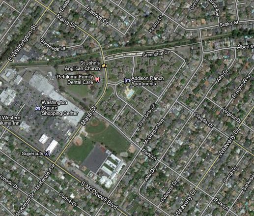
City of Petaluma                                                                       Safeway Fuel Center IS/MND

CITY OF PETALUMA
SAFEWAY FUEL CENTER- 335 SOUTH MCDOWELL BOULEVARD
CEQA ENVIRONMENTAL CHECKLIST AND INITIAL STUDY

OVERVIEW AND BACKGROUND

  Project Title:                                 Safeway Fuel Center
  Lead agency name and address:                  City of Petaluma
                                                 11 English Street
                                                 Petaluma, CA 94952

  Contact person and phone number:               Olivia Ervin, Environmental Planner
                                                 (707) 778-4556

  Project Location:                              335 South McDowell Boulevard
                                                 APN: 007-820-046

  Project sponsor’s name and address:            Matthew Francois
                                                 Rutan & Tucker, LLP.
                                                 Five Palo Alto Sqaure, 3000 El Camino Real, Ste. 200
                                                 Palo Alto, CA 94306
  Property Owners:                               Natalie Mattei
                                                 Senior Real Estate Manager
                                                 Safeway Inc.
                                                 11555 Dublin Canyon Road
                                                 Pleasanton, CA 94588
                                                 (925) 226-5754
  General plan designation:                      Community Commercial
  Zoning:                                        Commercial 2 (C2)
  Description of project:                        The project consists of the redevelopment of 0.71 acres
                                                 located in the Washington Core Subarea and includes Site
                                                 Plan and Architecture Review (SPAR). Site improvements
                                                 include the construction of a Safeway Fuel Center with 16
                                                                                           2
                                                 covered fuel pumping positions, a 697 ft retail convenience
                                                 store, landscaping and appurtenant parking. Site
                                                 preparation will include the demolition of the existing
                                                           2
                                                 13,770 ft commercial building and associated existing site
                                                 improvements.
  Surrounding land uses and setting;             The project site is located at the southeast corner of the
  briefly describe the project’s                 Washington Square shopping center, at the northwest
  surroundings:                                  corner of the South McDowell/Maria Drive intersection. The
                                                 project site is bounded by commercial retail to the west and
                                                 north, single-family residential south of the project site,
                                                 across South McDowell Blvd, and institutional and
                                                 recreational uses to the east across Maria Drive.
  Other public agencies whose approval           BAAQMD J number in order to allow for demolition.
  is required (e.g. permits, financial           BAAQMD Authority to Construct Permit to allow for
  approval, or participation agreements):        operation of a Gas Station.

  Have California Native American tribes         The Federated Indians of Graton Rancheria did not request
  traditionally and culturally affiliated with   consultation within the statutory timeframe provided by
  the project area requested consultation        Public Resources Code §21080.3.1. Notice was sent to
  pursuant to Public Resources Code              Graton Rancheria on June 8, 2017. The City of Petaluma
  section 21080.3.1? If so, has                  has not received a response from Graton Rancheria.
  consultation begun?

March 2018                                                                                           Page 2 of 65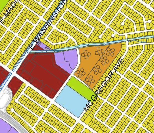
City of Petaluma                                                                                                                   Safeway Fuel Center IS/MND

                                                         SAFEWAY FUEL CENTER

TABLE OF CONTENTS                                                                                                                                         PAGE #

1.     OVERVIEW AND BACKGROUND ............................................................................................................. 4
1.1.        PROJECT DESCRIPTION ..................................................................................................................... 5
1.1.        PROJECT LOCATION .......................................................................................................................... 7
1.2.        ENVIRONMENTAL SETTING ............................................................................................................... 8
2.     ENVIRONMENTAL FACTORS POTENTIALLY AFFECTED ..................................................................... 9
3.     EVALUATION OF ENVIRONMENTAL IMPACTS .................................................................................... 10
3.1.        AESTHETICS ...................................................................................................................................... 10
3.2.        AGRICULTURAL AND FORESTRY RESOURCES ........................................................................... 13
3.3.        AIR QUALITY ...................................................................................................................................... 14
3.4.        BIOLOGICAL RESOURCES ............................................................................................................... 23
3.5.        CULTURAL RESOURCES .................................................................................................................. 26
3.6.        GEOLOGY AND SOILS ...................................................................................................................... 28
3.7.        GREENHOUSE GAS EMISSIONS ...................................................................................................... 31
3.8.        HAZARDS/HAZARDOUS MATERIALS .............................................................................................. 35
3.9.        HYDROLOGY AND WATER QUALITY .............................................................................................. 39
3.10.       LAND USE AND PLANNING .............................................................................................................. 41
3.11.       MINERAL RESOURCES ..................................................................................................................... 43
3.12.       NOISE .................................................................................................................................................. 43
3.13.       POPULATION AND HOUSING: .......................................................................................................... 48
3.14.       PUBLIC SERVICES ............................................................................................................................. 49
3.15.       RECREATION ..................................................................................................................................... 50
3.16.       TRANSPORTATION AND CIRCULATION ......................................................................................... 51
3.17.       TRIBAL CULTURAL RESOURCES .................................................................................................... 58
3.18.       UTILITIES AND SERVICE SYSTEMS ................................................................................................ 59
3.19.       MANDATORY FINDINGS OF SIGNIFICANCE (Cal. Pub. Res. Code §15065) ................................ 63
4.     REFERENCE DOCUMENTS: ................................................................................................................... 65

TABLE OF FIGURES

Figure 1 Site Aerial............................................................................................................................................ 7
Figure 2 General Plan Land Use ...................................................................................................................... 7
Figure 3 Safeway Fuel Center Rendering (South).......................................................................................... 8
Figure 4 Safeway Fuel Center Rendering (North) .......................................................................................... 8
Figure 5 Safeway Fuel Center Layout ............................................................................................................. 8

LIST OF TABLES

Table 1        Air Quality Thresholds of Significance ......................................................................................... 15
Table 2        Health Risk Thresholds of Significance ....................................................................................... 16
Table 3        Air Quality Construction Emissions ............................................................................................. 18
Table 4        Air Quality Operational Emissions ................................................................................................ 18
Table 5        Health Risk Exposure Construction.............................................................................................. 20
Table 6        Community Health Risk Exposure ................................................................................................ 20
Table 7        Cumulative Health Risk Exposure................................................................................................. 21
Table 8        GHG Emissions ............................................................................................................................... 34
Table 9        Construction Phase Noise Levels ................................................................................................. 46
Table 10       Summary of Existing Plus Project Conditions............................................................................. 53
Table 11       Summary of Background Plus Project Conditions...................................................................... 54
Table 12       Summary of Cumulative (2025) plus Project Conditions ............................................................ 55

March 2018                                                                                                                                             Page 3 of 65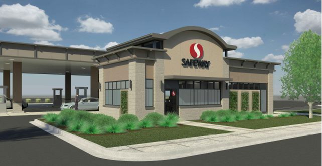
City of Petaluma                                                                           Safeway Fuel Center IS/MND

1. OVERVIEW AND BACKGROUND

General Plan: The Petaluma General Plan 2025, adopted in 2008, serves the following purposes:

  •        Reflects a commitment on the part of the City Council and their appointed representatives and staff to
           carry out the Plan;
  •        Outlines a vision for Petaluma’s long-range physical and economic development and resource
           conservation; enhances the quality of life for all residents and visitors; recognizes that human activity
           takes place within the limits of the natural environment; and reflects the aspirations of the community;
  •        Provides strategies and specific implementing policies and programs that will allow this vision to be
           accomplished;
  •        Establishes a basis for judging whether specific development proposals and public projects are in
           harmony with Plan policies and standards;
  •        Allows City departments, other public agencies, and private developers to design projects that will
           enhance the character of the community, preserve and enhance critical environmental resources, and
           minimize impacts and hazards; and
  •        Provides the basis for establishing and setting priorities for detailed plans and implementing
           programs, such as Development Codes, the Capital Improvement Program (CIP), facilities and
           Master Plans, redevelopment projects, and the Urban Growth Boundary (UGB).

General Plan EIR: Because CEQA discourages “repetitive discussions of the same issues” (CEQA
Guidelines section 15152b) and allows limiting discussion of a later project that is consistent with a prior plan
to impacts which were not examined as significant effects in a prior EIR or to significant effects which could
be reduced by revisions in the later project (CEQA Guidelines section 15152d), no additional benefit to the
environment or public purpose would be served by preparing an EIR merely to restate the analysis and the
significant and unavoidable effects found to remain after adoption of all General Plan policies/mitigation
measures. All General Plan policies adopted as mitigation apply to the subject Project.

The General Plan EIR reviewed all potentially significant environmental impacts and developed measures and
policies to mitigate impacts. Nonetheless, significant and unavoidable impacts were determined to occur
under the General Plan. Therefore, the City adopted a statement of overriding considerations, which balances
the merits of approving the project despite the potential environmental impacts. The impacts identified as
significant and unavoidable in the General Plan EIR are:

      •    Increased motor vehicle traffic which would result in unacceptable level of service (LOS) at six
           intersections covered in the General Plan:

               o   McDowell Boulevard North/Corona Road, Lakeville Street/Caulfield Lane, Lakeville
                   Street/East D Street, Petaluma Boulevard South/D Street, Sonoma Mt. Parkway/East
                   Washington Street, and McDowell Boulevard North/Rainier Avenue.

   •      Traffic related noise at General Plan buildout, which would result in a substantial increase in existing
          exterior noise levels that are currently above City standards.

   •      Cumulative noise from proposed resumption of freight and passenger rail operations and possible
          resumption of intra-city trolley service, which would increase noise impacts.

   •      Air quality impacts resulting from General Plan buildout to population levels that could conflict with the
          Bay Area 2005 Ozone Strategy. (This regional air quality plan has since been replaced by the Bay
          Area 2017 Clean Air Plan, which is further discussed in Sections 3.3 Air Quality and 3.7 Greenhouse
          Gases.)

   •      A possible cumulatively considerable incremental contribution to greenhouse gas emissions from
          development under the General Plan.

Because CEQA discourages “repetitive discussions of the same issues,” this environmental document tiers
off of the General Plan EIR (SCH NO.: 2004082065), which was certified on April 7, 2008, to examine site-
specific impacts of the proposed project, as described below. A copy of the City of Petaluma’s General Plan

March 2018                                                                                               Page 4 of 65
City of Petaluma Safeway Fuel Center IS/MND
and EIR are available at the Community Development Department, 11 English Street, Petaluma, California
94952, during normal business hours and online at http://cityofpetaluma.net/cdd/plan-general-plan.html.
1.1. PROJECT DESCRIPTION
The Safeway Fuel Center project proposes the development of a fuel station located at 335 South McDowell
Boulevard. The General Plan Land Use Designation is Community Commercial with a zoning designation of
Commercial 2 (C2). Gas Station is a permitted use under the Commercial 2 zoning. The project site is
2
comprised of 32,450 ft at the southeast corner of the Washington Square Shopping Center and is
surrounded by commercial, residential and institutional uses.
Site Preparation and Demolition
2
Site preparation will involve demolition of the existing 13,770 ft multi-tenant commercial building (c.1974) and
removal of existing site improvements including pavement, curbs, parking spaces and two ornamental trees.
The building is currently vacant and was previously occupied by retail uses. The existing commercial building
was subject to a limited asbestos and lead based paint survey that identified the presence of asbestos
containing material (ACM), but lead based paint (LBP) was not identified. All demolition activities are required
to adhere to applicable regulations in order to ensure safe removal and disposal of ACMs.
Site preparation will also include grading and the introduction of fill material to increase the site surface
grades to an elevation matching that of the adjacent parcels. Existing public utilities will remain in place and
will be used to service the new facilities onsite. The project will introduce an infiltration/bio-filtration trench that
serves to collect and filter stormwater emanating from the site. The gradient onsite will be constructed such
that all surface flows onsite are directed to the trench drain with filtered inserts or the infiltration/bio-filtration
trench in order to pre-treat runoff containing sediment and hydrocarbons (Civil C-2).
New Construction/Fuel Station
The project proposes the construction of a fuel center featuring 16 fuel positions (8 pumps with two fuel
positions per pump) located beneath a 62 by 95 foot canopy and a 697 square foot convenience store to
compliment the fuel station use. Associated site improvements include vehicle parking adjacent to the
convenience store (1 accessible stall, 4 standard stalls, and one electric vehicle charging station),
landscaping, and an exit driveway. The convenience store is proposed to be located along the southeast
edge of the project site abutting Maria Drive with parking located to the west. The proposed fuel pump island
will be located within the center portion of the site.
Construction activities are expected to take place over a six-month period. The construction will consist of site
preparation and demolition, construction of the fuel pumping stations and convenience store, paving and
application of architectural coatings.
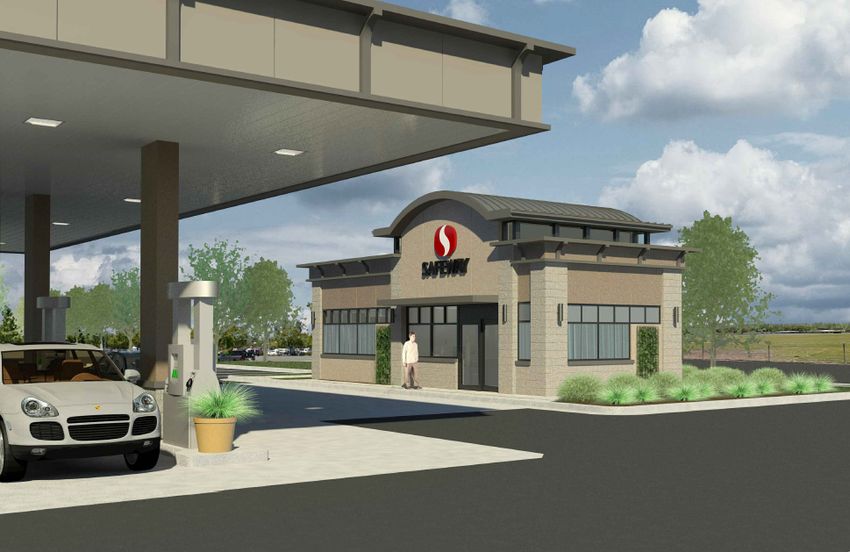
The convenience store will front onto Maria Drive and will feature an architectural treatment that is reflective
of the Safeway brand and consistent with the materials and colors at the existing Safeway store within the
shopping complex. The fueling station canopy will exhibit a clearance height of 16’ and a maximum height of
20’6” above grade. Materials of the canopy are proposed to consist of textured cement, painted plaster and
finished with neutral tones and colors.
The convenience store building has a height of 15’8” from grade to top of roof. The finish materials for the
façade include stucco, cement and concrete. The north elevation faces interior to the pump island and
contains the primary entrance and features two aluminum doors with large storefront windows. The southern
elevation faces the Maria Drive frontage and contains a pedestrian entrance through a single aluminum
doorway.
All four elevations are treated with a series of vertical windows complimented by a row of horizontal windows
above. Trellis screens to support climbing vines are provided on all four elevations. The project includes LED
lights located on the canopy ceiling and three yard lights distributed around the periphery of the site. The
fueling station and associated convenience store have been designed in accordance with (C2) development
standards and is subject to site plan and architectural review (SPAR).
March 2018 Page 5 of 65City of Petaluma Safeway Fuel Center IS/MND As proposed, the project will introduce approximately 8,000 square feet of landscaping including vegetation, a bio-filtration trench and permeable cobbles that will replace the existing landscaping (2,971 square feet). The preliminary landscape plan incorporates drought tolerant plant materials of various species contained within a landscape strip that wraps around the South McDowell Boulevard frontage and the Maria Drive frontage. The landscaping plan retains several existing trees and introduces groundcover, shrubs and new trees within the landscaping strip. A continuous hedge of evergreen shrubs is proposed adjacent to the parking stalls in order to provide a vegetative screen. Site Operations The proposed hours of operation for the fuel center is from 6:00 am until 11:00 pm daily. The fueling pumps will dispense both unleaded and diesel fuels that will be available from 8 multi-product fuel dispensers. A total of 16 fuel pump stations will provide an opportunity for the simultaneous fueling of SUVS, full size pick-up trucks as well passenger vehicles. The annual throughput of gasoline will not exceed 8.5 million gallons. The fuel dispensers will be served by two 20,000-gallon underground storage tanks. The operation of the fuel station will require twice daily truck deliveries of fuel that will occur in the morning and evening for a period of approximately thirty to forty minutes. Truck idling during delivery will be limited to less than 5 minutes. The delivery trucks will align parallel to the underground storage tanks, on the western portion of the site. The location of the trucks during fuel delivery is designed to avoid conflict with fuel dispensing activity and not interfere with vehicle queuing. The convenience store is proposed to operate from 6:00 am until 11:00 pm and will sell pre-packaged items, drinks and coffee as well basic auto related items including motor oil. No truck deliveries of merchandise to the convenience store will occur, as retail products will be brought over by cart from the adjacent Safeway Store. Site Access The site is currently accessed via a driveway located on Maria Drive and from the interior of the shopping center. At operation ingress will be provided via the existing entrance driveway on Maria Drive and from the internal drive aisles that transect the shopping center. Egress will be provided by an exit only driveway onto Maria Drive and an exit only driveway at the southwest portion of the project site which outlets to a drive aisle within the shopping center. Directional signs will be installed at all egress/ingress points to indicate the “DO NOT ENTER” and “DO NOT BLOCK” areas. The queuing area for vehicles waiting to fuel has been designed to accommodate at least 12 vehicles outside of the fuel canopy area. As proposed, Safeway will employ personnel to serve as “Fuel Ambassadors.” These employees will be positioned in and around the fueling area to direct vehicles to open pumps and provide assistance within the fueling area. “Fuel ambassadors” are proposed during peak hours (7-9 am and 4-6 pm weekdays and 11 am - 1 pm on Saturdays) to ensure that cross flow traffic through the parking lot is not impeded and that efficient circulation of vehicles and customers is maintained. Off-Site Improvements The proposed fuel station parcel abuts the existing Transit Center located along the west side of Maria Drive. In order to maintain adequate site distance when buses are parked at the stop, the project proposes a bus turn out area that will improve the line of site for vehicles exiting the Maria Drive fuel station exit. The Transit Center is proposed to be modified to increase the width of the bus turnout area, which will allow buses to queue outside of the Maria Drive travel lane. Additionally, the Transit Center amenities will be enhanced to include a new shelter, seating, landscaping and ancillary improvements. Project Entitlements: The applicant has applied to the City of Petaluma for Site Plan and Architectural Review (SPAR). March 2018 Page 6 of 65
City of Petaluma                                                                        Safeway Fuel Center IS/MND

    1.1. PROJECT LOCATION

For discussion purposes, the project site is presumed to be oriented north/south with McDowell Blvd. and
Hwy 101 to the west (see project north below). The project site is located at 335 South McDowell Boulevard in
Petaluma, CA, which is a developed commercial parcel within an urbanized area (Figure 1). The assessor
parcel number of the subject site is 007-820-046. The 0.75-acre parcel is located in the southeastern portion
of the Washington Square shopping center, which is also the northwest corner of the South McDowell
Boulevard/Maria Drive intersection. The project site is bounded by commercial retail to the north and west,
single-family residential to the south of the project site across South McDowell Blvd., and institutional and
recreational uses to the east, across Maria Drive. To the northeast of the Shopping Center is land designated
Medium Density Residential, which underwent a land use amendment as part of the approved Maria Drive
Apartments Project (See Figure 2). Other development projects located in close proximity to the project site
include the Addison Ranch Apartment Complex at 200 Greenbriar, which is currently under construction to
provide an additional 100 residential units within the existing Apartment Complex.

Figure 1: Site Aerial                                  Figure 2: General Plan Land Use

                                                                          MARIA Dr.

  Legend                                                Legend

  Safeway Fuel Center                     Project       Safeway Fuel Center                           Project
                                          North                                                       North

                                                        Medium Density Residential
                                                        Low Density Residential
  Project Site                                          Mixed-Use
                                                        City Park
                                                        Community Commercial
                                                        Education

  Source: Google Maps 2014
                                                        Source: GP 2025 Figure 1-1 Land Use

March 2018                                                                                            Page 7 of 65
City of Petaluma Safeway Fuel Center IS/MND
Figure 3: Safeway Fuel Center Rendering (South) Figure 4: Safeway Fuel Center Rendering (North)
Figure 5: Safeway Fuel Center Layout
1.2. ENVIRONMENTAL SETTING
Petaluma is located in southwestern Sonoma County along
the 101 corridor approximately 15 miles south of Santa Rosa
and 20 miles north of San Rafael. It is situated at the
northernmost navigable end of the Petaluma River, a tidal
estuary that drains to the San Pablo Bay. The City originated
along the banks of the Petaluma River, spreading outward
over the floor of the Petaluma River Valley as the City
developed. The Valley itself is defined by Sonoma Mountain
on the northeast and by the hills extending northward from
Burdell Mountain on the west. To the south are the Petaluma
Marshlands and the San Francisco Bay beyond.
Petaluma’s Urban Growth Boundary (UGB) defines the limits
within which urban development may occur and
encompasses approximately 9,911 acres. The UGB was
implemented in 1987 (as the Urban Limit Line), formally
adopted as the UGB in 1998 via Measure I, and will expire in
2018 without subsequent action. The General Plan and EIR
evaluated potential impacts associated with existing and
proposed development within the UGB.
The project site consists of an underutilized lot with an
existing commercial building constructed circa 1974. The site
is an urbanized area within central Petaluma that is well
served by public utilities and services. The site is located
within the Washington Square Shopping Center, which is a community serving retail center with Safeway
serving as the largest retailor. The project site and vicinity are largely developed and have been since the late
1960s. The project site is well connected to the rest of the City and outer environs as it maintains frontage on
two major arterials and has connectivity to Highway 101.
The project site is generally flat and paved with asphaltic concrete. At present, there is a limited amount of
landscaping that includes ornamental shrubs and trees totaling approximately 2,971 square feet of the total
site (32,450 square feet). Two of the twelve existing trees are proposed for removal and will be replaced with
the introduction of four Red Maples and four Photinia Fraseris. Tree removal and replacement is further
discussed in Section 3.4, Biological Resources, below.
March 2018 Page 8 of 65City of Petaluma Safeway Fuel Center IS/MND
2. ENVIRONMENTAL FACTORS POTENTIALLY AFFECTED
The environmental factors checked below would be potentially affected by this project, involving at
least one impact that is a "Potentially Significant Impact Unless Mitigation is Incorporated" as
indicated by the checklist on the following pages.
1. Aesthetics X 8. Hazards & Hazardous X 15. Recreation
Materials
2. Agricultural & 9. Hydrology / Water 16. Transportation / Traffic X
Forestry Resources Quality
3. Air Quality X 10. Land Use / Planning 17. Tribal Cultural
Resources
4. Biological Resources X 11. Mineral Resources 18. Utilities /
Service Systems
5. Cultural Resources X 12. Noise X 19. Mandatory Findings of
Significance
6. Geology / Soils X 13. Population / Housing
7. Greenhouse Gas 14. Public Services
Emissions
DETERMINATION (To be completed by the Lead Agency)
On the basis of this initial evaluation:
I find that the proposed project COULD NOT have a significant effect on the environment. A
NEGATIVE DECLARATION will be prepared.
I find that although the proposed project could have a significant effect on the environment,
there will not be a significant effect in this case because revisions in the project have been X
made by or agreed to by the project proponent. A MITIGATED NEGATIVE DECLARATION
will be prepared.
I find that the proposed project MAY have a significant effect on the environment, and an
ENVIRONMENTAL IMPACT REPORT is required.
I find that the proposed project MAY have a "potentially significant impact" or "potentially
significant unless mitigated" impact on the environment, but at least one effect 1) has been
adequately analyzed in an earlier document pursuant to applicable legal standards, and 2)
has been addressed by mitigation measures based on the earlier analysis as described on
attached sheets. An ENVIRONMENTAL IMPACT REPORT is required, but it must analyze
only the effects that remain to be addressed.
I find that although the proposed project could have a significant effect on the environment,
because all potentially significant effects (a) have been analyzed adequately in an earlier EIR
or NEGATIVE DECLARATION pursuant to applicable standards, and (b) have been avoided
or mitigated pursuant to that earlier EIR or NEGATIVE DECLARATION, including revisions or
mitigation measures that are imposed upon the proposed project, nothing further is required.
__________________________________________ March 28, 2018
Signature: Olivia Ervin, Environmental Planner Date
March 2018 Page 9 of 65City of Petaluma Safeway Fuel Center IS/MND
3. EVALUATION OF ENVIRONMENTAL IMPACTS
The following discussion addresses the potential level of impact relating to each aspect of the environment.
3.1. AESTHETICS
Less Than
Potentially Significant Less than
No
Significant with Significant
Would the project: Impact Mitigation Impact
Impact
Incorporated
a) Have a substantial adverse effect on a scenic vista?
b) Substantially damage scenic resources, including, but
not limited to, trees, rock outcroppings, and historic
buildings within a state scenic highway?
c) Substantially degrade the existing visual character or
quality of the site and its surroundings?
d) Create a new source of substantial light or glare
which would adversely affect day or nighttime views in
the area?
Sources: 2025 General Plan and DEIR; and Site Plans.
Aesthetics Setting:
The project site is comprised of approximately 0.71 acres of land located in the Washington Core Subarea
(Figure 2-1 of the General Plan) within the Urban Growth Boundary. The Washington Core Subarea supports
a diverse mix of uses that include local and regional-serving commercial, community fair grounds and
residential. The subject project site is located contiguous to the southeast planning area, which is largely
defined by residential and institutional land uses. The site is bounded by regional/local serving commercial to
the north, institutional to the east, residential to the south and commercial to the west. There are no visual
resources on the project site or visible from the project site.
The project will involve demolition of the existing 13,770 square foot commercial retail building and
development of a 16 pump fueling station and associated convenience store parking and landscaping. The
existing commercial building to be demolished is a rectilinear, horizontally oriented building characteristic of
strip mall development. The outside is clad in brick and the existing landscape is minimal and consists of a
narrow landscape strips with grasses, shrubs and equally spaced trees. The balance of the proposed project
site features paved areas that are devoted to parking stalls and driveway aisles.
Redevelopment of the site will involve the introduction of a 697 square foot convenience store with frontage
on Maria Drive and the construction of a canopy covering 16 position fueling station located west of the store.
The convenience store and associated fueling station will feature a composite of neutral colored materials,
horizontal orientation and limited detailing. Proposed landscaping includes the introduction of street trees,
evergreen hedges to serve as screening and a variety of low maintenance, low water use plants oriented
along South McDowell Boulevard and the Maria Drive frontage. Proposed vegetation includes Red Maple,
Photinia Fraseri STD., Abbotts Gold (Pittosporum Tenuifolium), African Boxwood (Myrsine Africana), Fortnight
Lily (Dietes Irridoides), Confetti (Abelia X), Maordi Maiden/ New Zealand Flax (Phormium Tenax), Blue Oat
Grass (Helicotrichon Sempervirens), Dwarf Blue Fescue (Festuca Glauca), Lantana (Lantana
Montedividensis) and yellow Flower Carpet Rose.
March 2018 Page 10 of 65City of Petaluma Safeway Fuel Center IS/MND Aesthetics Impact Discussion: 3.1(a) (Scenic Vista) No Impact: The 2025 General Plan EIR identifies vistas of Sonoma Mountain and the Petaluma Valley as significant visual resources with notable viewpoints seen from the Washington Street Overpass, McNear Peninsula and Rocky Memorial Dog Park. The proposed fuel station is not located in the direct vicinity to any of the notable viewpoints and would neither obstruct nor diminish any existing viewsheds. The project is proposed on a developed parcel located within the bounds of the UGB. Since the site is surrounded by existing development on all sides the project is considered infill. The GP EIR states that within the built city, infill development would not have a significant effect on the visual quality of the city, because new development would likely be similar in scale and character to existing development. Accordingly, the proposed development would not be expected to have a substantial adverse impact on panoramic views or create incongruous visual elements because the height and massing of new development would be similar to the existing development in the vicinity and would not interfere with a scenic vista. The proposed fuel station is compatible in scale and style with the existing Safeway Grocery Store. There is a substantial increase in the landscaping area proposed relative to the existing condition. Therefore, development of the proposed Fuel Center would have no impacts to scenic vistas or views of significant landscape features. 3.1(b) (Resources viewed from a State Designated Scenic Highway) No Impact: No State Scenic Roadway traverse the planning area. Therefore, no scenic resources, including, but not limited to; trees, rock outcroppings, and/or historic buildings visible from a State Scenic Highway would be impacted. 3.1(c) (Visual Character and Quality) Less Than Significant Impact: The addition of a fuel station to the Washington Square Shopping Center will not significantly depart from the existing character of the shopping center. The existing 13,770 square foot building onsite will be demolished under the proposed project and replaced with the proposed 697 square foot convenience store and fueling area. The proposed redevelopment will reduce the building scale and massing relative to the existing condition. The existing building onsite consists of a solid mass oriented perpendicular to South McDowell Boulevard. It is composed of beige colored concrete masonry units and an aluminum roof. There are a series of tenants with entryways facing onto Maria Drive. The proposed Safeway Fuel Center will be oriented towards South McDowell Boulevard. The 687 square foot convenience store represents a substantial reduction in scale and mass, and the open area of the fuel canopy allows for increased visibility compared to the existing building onsite. As proposed, the Fuel Center would be improved with an architectural styles that reflect the existing style at the adjacent Safeway Grocery Store. The project site is proximate to residential and institutional uses. Redevelopment would alter the visual environment relative to the existing condition. However, the character of the Shopping Center will be largely retained. The project will introduce landscaping and vegetative screening beyond what is currently present by increasing the planting area. Furthermore, the project location within the existing commercial development is consistent with the overall character that defines the Washington Square Shopping Center. As such, the project is not expected to alter the character of the surrounding residential neighborhood as it is associated with the commercial shopping center. The adjacent roadways including Maria Drive and South McDowell Boulevard provide a distinct separation between the limit of the shopping center and that of the residential and institutional land uses in proximity. The proposed Safeway Fuel Center will not create any substantial visual dissonance that would degrade the existing visual quality of the surrounding area. Therefore impacts to the visual character of the site and the surrounding land uses would be less than significant. 3.1(d) (Light and Glare) Less Than Significant Impact with Mitigation: The Washington Square Center is an active commercial land use that contains a number of retailors and a large parking lot outfitted with streetlights. Onsite uses and uses in the project vicinity emit light and glare typical of a retail/commercial. The proposed fuel station will feature a canopy above the fueling pumps that will contain one recessed LED canopy light (Series Type A60-SL) per fuel pump and will exhibit an average illuminance of 23.10. The foot- candles (fc) emitted from the recessed canopy lights will not exceed 28 fc under the canopy and will be limited March 2018 Page 11 of 65
City of Petaluma                                                                             Safeway Fuel Center IS/MND

to 0.0 or 0.1 fc at the periphery of the site. The direction of the light will be downcast and directed underneath
the canopy. A wall light (Visa lighting #Extoi) will be installed on the façade of the convenience store.

A series of three-yard lights will be strategically placed throughout the site, in order to provide safety lighting
and visibility. The proposed project is required to conform to Petaluma’s implementing zoning ordinance (IZO)
§ 21.040.D, which specifies lighting standards for all new exterior lights such as the provision that the cone of
direct illumination be sixty degrees if the luminary is greater than 6 feet above the ground.

In addition to the proposed on-site lighting fixtures, the project will introduce headlights and taillights from
vehicles entering, exiting and queuing. Vehicles will enter the Gas Station internally from the Shopping Center
drive aisle and will orient towards S. McDowell Boulevard for fueling (See Figure 5). Although vehicles will be
turned off while fueling, headlights may remain on while queuing or fueling. Additionally, headlights will be in the
on position during entry and exit and could result in impacts due to direct light and glare. In order to reduce light
intrusion onto adjacent properties, the site will feature screening and landscaping up to a height of 4 feet
coupled with trees up to 35 feet that will serve to block and/or filter light and glare generated by vehicles utilizing
the fuel station and associated convenience store. The landscape buffer is adequately sized at 28 feet in width
to accommodate a suitable range of groundcover, shrubs and trees for planting an effective landscaping screen.
In order to ensure that landscaping achieves sufficient screening of headlights mitigation measure AES-1 is set
forth below and requires that the Final Landscaping Plan provide an appropriate plant pallet to achieve the
necessary height and density to block light and glare from headlights using the fuel station. With implementation
of AES-1 potential impacts due to light and glare intrusion will be reduced to less than significant levels.

Mitigation Measures:

AES-1: The Final Landscaping Plan shall provide sufficient screening by placement of grasses, shrubs and
other groundcover species to effectively screen out glare from headlights oriented towards South McDowell
Boulevard and towards Maria Drive. A variety of heights shall be introduced through the landscaping plan
including a dense 4-foot high screen that blocks glare emanating from headlights.

March 2018                                                                                                Page 12 of 65
City of Petaluma                                                                              Safeway Fuel Center IS/MND

3.2.     AGRICULTURAL AND FORESTRY RESOURCES

                                                                              Less Than
                                                               Potentially    Significant   Less than
                                                                                                            No
                                                               Significant        with      Significant
                                                                                                          Impact
   Would the project:                                            Impact        Mitigation     Impact
                                                                             Incorporated

   a) Convert Prime Farmland, Unique Farmland, or
   Farmland of Statewide Importance (Farmland), as
   shown on the maps prepared pursuant to the
   Farmland Mapping and Monitoring Program of the
   California Resources Agency, to non-agricultural
   use?

   b) Conflict with existing zoning for agricultural use, or
   a Williamson Act contract?

   c) Conflict with existing zoning for, or cause rezoning
   of, forest land (as defined in Public Resources Code
   section 12220(g)), timberland (as defined by Public
   Resources Code section 4526), or timberland zoned
   Timberland Production (as defined by Government
   Code section 51104(g))?

   d) Result in the loss of forest land or conversion of
   forest land to non-forest use?

   e) Involve other changes in the existing environment
   which, due to their location or nature, could result in
   conversion of Farmland, to non-agricultural use or
   conversion of forest land to non-forest use?

   Sources: 2025 General Plan and DEIR.

Agricultural Setting:

Agricultural lands within the Urban Growth Boundary (UGB) are limited to “Farmland of Local Importance”,
“Grazing Land”, and “other land” and there are no identified forestlands within the City of Petaluma. No
agricultural or forestland designations are present on or near the project site.

Agricultural Resources Impact Discussion:

3.2(a-e) (Farmland Conversion, Williamson Act, Forestland/Timberland Conflict) No Impact: The project
site does not include any agricultural or forested lands. The project, as proposed, consists of infill
development located on a developed lot and will not impact prime farmland, unique farmland or farmland of
statewide importance. The project will not interfere with Williamson Act contracts or any existing agricultural
uses.

In the absence of forested lands there is no potential for the project to conflict with existing forested land
zoning or encourage the loss or conversion of forested land to another use. As the project is infill within the
UGB it will not provide an impetus for the conversion of farmland or forest to any alternative use. Therefore,
the project will have no impact to agricultural and forestry resources.

Mitigation Measures: None Required.

March 2018                                                                                                 Page 13 of 65
City of Petaluma Safeway Fuel Center IS/MND
3.3. AIR QUALITY
Less Than
Potentially Significant Less than
No
Significant with Significant
Would the project: Impact Mitigation Impact
Impact
Incorporated
a) Conflict with or obstruct implementation of the
applicable air quality plan?
b) Violate any air quality standard or contribute
substantially to an existing or projected air quality
violation?
c) Result in a cumulatively considerable net
increase of any criteria pollutant for which the
project region is in non-attainment under an
applicable federal or state ambient air quality
standard (including releasing emissions which
exceed quantitative thresholds for ozone
precursors)?
d) Exposure of sensitive receptors to substantial
pollutant concentrations?
e) Create objectionable odors affecting a
substantial number of people?
Sources: 2025 General Plan and DEIR; Bay Area Air Quality Management District (BAAQMD) Bay Area 2017
Clean Air Plan; BAAQMD CEQA Guidelines, May 2017; BAAQMD Regulation 8 Organic Compound Rule 7
Gasoline Dispending Facilities, November 6, 2002; Safeway Fuel Center Air Pollutant and Greenhouse Gas
Emissions Assessment, prepared by Illingworth & Rodkin, January 8, 2014, Revised September 18, 2017;
Safeway Fuel Center Health Risk Assessment, prepared by Illingworth & Rodkin, January 8, 2014, Revised
September 19, 2017; and Limited Asbestos and Lead-Based Paint Survey, prepared by Cardno ATC,
May 29, 2013.
Air Quality Setting:
The City of Petaluma including the project site is located within the San Francisco Bay Area Air Basin (Bay
Area Air Basin), which is under the jurisdiction of the Bay Area Air Quality Management District (BAAQMD).
BAAQMD is charged with managing air quality for the region through the implementation of planning,
regulation, enforcement, technical innovation and education. The intent of which is to achieve conformance
with established air quality standards that are set by the U.S. Environmental Protection Agency for the
Federal Clean Air Act and the California Air Resources Control Board for the California Clean Air Act.
The BAAQMD operates several air quality monitoring stations, whereas the closest station to the City of
Petaluma is located in eastern Sebastopol, approximately 16 miles northwest. The Sebastopol station records
pollutant concentration levels for carbon monoxide (CO), Nitrogen Dioxide (NO2), Ozone (O3), and Particulate
Matter (PM2.5).
The Bay Area Air Basin is designated as non-attainment for both the one-hour and eight-hour state and
national ozone standards; 0.09 parts per million (ppm) and 0.070 ppm, respectively. The Basin is also in non-
attainment for the PM10 and PM2.5 state standards, which require an annual arithmetic mean (AAM) of less
3 3
than 20 µg/m for PM10 and less than 12 µg/m for PM2.5. In addition, the Bay Area Air Basin is designated as
non-attainment for the national 24-hour PM2.5 standard. All other national ambient air quality standards within
1
the Bay Area Air Basin are in attainment.
1
2017 Bay Area Clean Air Plan, prepared by the Bay Area Air Quality Management District, April 2017.
March 2018 Page 14 of 65City of Petaluma Safeway Fuel Center IS/MND
Air quality emissions of carbon monoxide (CO), ozone precursors (ROG and NOx) and particulate matter
(PM10 and PM2.5) from construction and operation are evaluated pursuant to the BAAQMD CEQA Air Quality
2
Guidelines established in May 2010 and most recently updated in May 2017. The most recent version of the
BAAQMD CEQA Guidelines includes revisions made to address the Supreme Court’s opinion issued for the
3
California Building Industry Association v. Bay Area Air Quality Management District, in December 2015.
The May 2017 Guidelines update does not address outdated references, links, analytical methodologies or
other technical information that may be in the Guidelines or Thresholds Justification Report.
The BAAQMD is currently working to update any outdated information in the Guidelines, and anticipates
4
release of an updated document in 2018. Based upon its own judgment and analysis, the City of Petaluma
recognizes that BAAQMD thresholds represent the best available scientific data and has elected to rely on
BAAQMD Guidelines dated May 2017 in determining screening levels and significance.
Thresholds of significance as established by BAAQMD for construction and operation are provided in Table 1
below.
Table 1
Air Quality Thresholds of Significance
Pollutant Construction Thresholds Operational Threshold
(lbs per day) (lbs per day)
ROG 54 54
Nox 54 54
PM10 82 82
PM2.5 54 54
CO Not Applicable 9.0 ppm (8-hour avg.) or
20.0 ppm (1-hour avg.)
Fugitive Dust Construction Dust Not Applicable
Ordinance or other Best
Management Practices
Source: BAAQMD’s CEQA Guidelines: May 2017.
In addition to the Guidelines, BAAQMD has established rules in order to ensure that projects conform to air
quality regulation. The Safeway Fuel Center Project is subject to several of the Rules established by
BAAQMD including Regulation 11, Rule 2 for the control and management of asbestos containing materials,
Regulation 8, Rule 7 to control for the emission of reactive organic compound (ROG) from a stationary source
emitter due to fuel dispensing onsite, and Regulation 7 which controls for odors.
The subject Safeway Fuel Center, as a proposed fuel dispensing operation, is considered a stationary source
emitter, and is regulated to control for the emission of reactive organic compound (ROG) pursuant to
Regulation 8, Rule 7 of the BAAQMD Rules and Regulations. Rule 7 requires that stationary source emitters
such as the Safeway Fuel Center install enhanced vapor recovery (EVR) systems. Since the Safeway Fuel
Center would emit more than 10 pounds of ROG (i.e., volatile organic compounds or VOCs) in a single day,
2
Adopted by Board of Directors of the BAAQMD in June 2010 (Resolution No. 2010-6).
3
In March 2012, the Alameda County Superior Court ordered BAAQMD to set aside use of the significance thresholds
within the BAAQMD 2010 CEQA Guidelines and cease dissemination until they complete an assessment of the
environmental effects of the thresholds in accordance with CEQA. The Court found that the thresholds, themselves,
constitute a “project” for which environmental review is required. In August 2013, the First District Court of Appeal
reversed the Alameda County Superior Court’s decision. The Court held that adoption of the thresholds was not a
“project” subject to CEQA because environmental changes that might result from their adoption were too speculative
to be considered “reasonably foreseeable” under CEQA. In December 2015, the California Supreme Court reversed
the Court of Appeal's decision and remanded the matter back to the appellate court to reconsider the case in light of
the Supreme Court's opinion.
4
Alison Kirk, BAAQMD, Email Correspondence, June 6, 2017.
March 2018 Page 15 of 65City of Petaluma Safeway Fuel Center IS/MND
the Best Available Control Technology (BACT) requirement of Regulation 2-2-301 would be triggered. BACT
for Gasoline Dispensing Facilities is considered the use of California Air Resource Board (CARB)-certified
Phase-I and Phase-II vapor recovery equipment. The Safeway Fuel Center obtained a permit to construct and
5
operate from the BAAQMD and an extension was filed in October 2017. According to the BAAQMD’s permit
evaluation, the project would meet the requirement by using CNI EVR Phase I equipment and VST Balance
EVR Phase II equipment with the Veeder-Root Vapor Polisher and Veeder-Root ISD controls. These two
systems are certified by CARB under Executive Orders VR-104 and VR-204 respectively.
To ensure that the Safeway Fuel Center does not emit ROG emissions that would trigger requirements for
emission offsets, or exceed screening triggers that would require a health risk assessment, BAAQMD
conditioned the facility to a gasoline throughput not to exceed 25.71 million gallons of fuel per year. Even
though the project’s annual throughput is expected to be approximately 8.5 million gallons per year, which is
less than one-third of the screening triggers set by BAAQMD, a Health Risk Assessment has been prepared
for the project (see Section 3.3(d) below).
Regulation 2, Rule 5 of the BAAQMD Rules and Regulations controls for the evaporation of vapors, including
Toxic Air Contaminant (TAC) such as benzene. TACs are defined by CARB as those pollutants that “may
cause or contribute to an increase in deaths or serious illness, or which may pose a present or potential
hazard to human health.” TACs are chemical compounds that result from industry, agriculture, fuel
combustion, and commercial operations. In the context of the subject project expected TACs include diesel
particulate matter (DPM), non-diesel total organic gases (TOG), fine particulate matter (PM2.5), and benzene.
DPM consists of diesel exhaust that contains a mixture of gases, vapors, and fine particles. TOGs are emitted
by gasoline powered vehicles from running exhaust and evaporative running losses. Benzene is a component
of gasoline, diesel fuel and vehicle exhaust that is emitted through the evaporation of gasoline vapors. TACs
are regulated at the state and federal level on the basis of risk to human health. BAAQMD prepared a Health
Risk Screening Analysis for the Safeway Fuel Center because the increased benzene emissions for the
project exceed the TAC risk triggering level specified in Table 2.5-1 of Regulation 2, Rule 5. According to
BAAQMD’s evaluation, the Safeway Fuel Center passed the toxic risk screening level of less than ten in a
6
million cancer risk with the BAAQMD-imposed annual throughput limit of 25.71 million gallons.
BAAQMD has established thresholds of significant for exposure to TAC and PM2.5 as part of the
aforementioned Guidelines. These thresholds are utilized in order to identify potentially significant health risk
impacts that may result from exposure to sensitive populations. Table 2 below provides the Community Risk
Thresholds for determining significance due to a health risk introduced by development.
Table 2
Health Risk Thresholds of Significance
Excess Cancer Non-Cancer PM2.5
3
Risk Hazard Index µg/m
Single Source >10 in 1 million >1.0 >0.3
Cumulative Source >100 in 1 million >10.0 >0.8
Source: BAAQMD’s CEQA Guidelines: May 2017.
Single sources would be considered to have a potentially significant health risk impact if they would exceed
any of the established thresholds set forth in Table 2. Cumulative sources would be considered to have
potentially significant impact if any of the thresholds in Table 2 were exceeded due to the aggregate total of all
past, present and foreseeable sources within the 1,000 foot radius of the fence line of a source or from the
location of a sensitive receptor plus the contribution from the project.
The following discussion analyzes the project’s potential to result in an air quality impacts due to construction
and the proposed onsite use.
5
BAAQMD 2013. Authority to Construct for Permit Application No. 405215 at S. McDowell Blvd. & Maria Drive,
Petaluma CA 94954, dated October 10, 2013.
6
Ibid.
March 2018 Page 16 of 65City of Petaluma Safeway Fuel Center IS/MND Air Quality Impact Discussion: 3.3(a) (Air Quality Plan) Less than Significant Impact: The BAAQMD adopted the 2017 Bay Area Clean Air Plan (CAP) in April 2017 to comply with state air quality planning requirements set forth in the California Health & Safety Code. The 2017 CAP includes a wide range of control measures designed to decrease emissions of the air pollutants that are most harmful to Bay Area residents, such as particulate matter (PM), ozone (O3), and toxic air contaminants (TACs); to reduce emissions of methane and other “super-greenhouse gases (GHGs)” that are potent climate pollutants in the near-term; and to decrease emissions of carbon dioxide by reducing fossil fuel combustion. The proposed control strategy for the 2017 CAP consists of 85 distinct measures targeting a variety of local, regional and global pollutants. The control measures have been developed for stationary sources, transportation, energy, buildings, agriculture, natural and working lands, waste management, water, and super-GHG pollutants. Implementation of some of the control measures could involve retrofitting, replacing, or installing new air pollution control equipment, changes in product formulations, or construction of infrastructure that have the potential to create air quality impacts. The BAAQMD CEQA Guidelines set forth criteria for determining consistency with the CAP. In general a project is considered consistent if a) the project supports the primary goals of the CAP (to protect air quality, protect public health, and protect the climate), b) includes control measures and c) does not interfere with implementation of the CAP measures. Development of the proposed Safeway Fuel Center Project is consistent with the CAP as it supports the primary goals by providing a new fueling center proximate to existing retail which would reduce overall vehicle miles traveled, includes basic control measures and would not result in any conflicts in implementing the CAP. Therefore, the project would have less than significant impacts due to a conflict with the regional air quality plan. 3.3(b-c) (Air Quality Standard, Criteria Pollutant) Less than Significant Impact with Mitigation: A project-specific Air Pollutant and Greenhouse Gas Emissions Assessment was prepared by Illingworth and Rodkin (September 2017) that analyzed construction emissions, tailpipe emissions, and evaporative emissions (See Appendix A). In accordance with BAAQMD direction, the Assessment utilized the California Emissions Estimator Model, Version 2016.3.1 (CalEEMod) to quantify projected construction and operational emissions generated by the proposed Safeway Fuel Center. As described in the methodology discussion of the Assessment, a Gasoline/Service Station with 16 fuel pump stations, was entered into the model. In order to evaluate the emissions generated by vehicles idling due to queuing and wait times during peak hour fueling activity, the Air Pollutant and Greenhouse Gas Emissions Assessment utilized CARB’s EMFAC2014 motor vehicle emission factor model. The idling analysis assumed that the peak-hour would have 12 vehicles (light-duty autos or light-duty trucks) queuing constantly, which would be three vehicles for each line of pumps; this represents the worst-case scenario based on the maximum queuing space available. The analysis also assumed that the peak hour represents 10 percent of the daily queuing emissions. The transfer and storage of gasoline results in emissions of VOCs also assumed to be ROGs. These gases, when combined with NOx, lead to ozone formation. The emission factors developed by BAAQMD are based on the Gasoline Service Station Industry-wide Risk Assessment Guidelines prepared by the California Air Pollution Officers Association’s (CAPCOA) Toxics Committee. BAAQMD’s emission computations are based on annual throughput that account for emissions from fuel storage tank loading, breathing, and motor vehicle refueling/dispensing for underground tanks that meet current requirements for enhanced vapor recovery. The Air Pollutant and Greenhouse Gas Emissions Assessment prepared by Illingworth and Rodkin used a ROG emission factor of 0.670 pounds of Precursor Organic Compounds (i.e., ROG) per 1,000 gallons of fuel throughput. Annual and daily emissions were computed to reflect the anticipated annual throughput of approximately 8.5 million gallons. While the BAAQMD conditioned the facility to a gasoline throughput not to exceed 25.71 million gallons of fuel per year, the proposed project was analyzed assuming an annual throughput of 8.5 million gallons. In the future, should the applicant decide to increase the annual throughput limit beyond 8.5 million gallons per year, subsequent environmental review in accordance with CEQA regulations may be required by the City of Petaluma. Air Quality Emissions during Construction March 2018 Page 17 of 65
You can also read