Draft City Centre Character Appraisal Bath Conservation Area - Bath and North East Somerset Council Development
←
→
Page content transcription
If your browser does not render page correctly, please read the page content below
Bath and North East Somerset Council
Development

Draft City Centre Character Appraisal
Bath Conservation Area

November 2015
Contents
1. Introduction and description of the 1
Character Area
2. Summary of key characteristics 6
3. Historic development 11
4. Cultural influences 17
5. Archaeology 20
6. Landmarks and views 22
7. Land uses and their influences 24
8. Buildings, architectural quality and 26
townscape
9. Materials and detailing 32
10. Streets and movement 36
11. Trees, open space, parks and gardens 39
12. Night-time character 41
13. Issues affecting the Character Area 45
Annexe 1. Maps 47
Map of landmarks and views
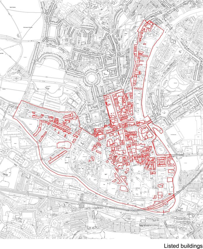
Map of listed buildings
Map of architectural and townscape features
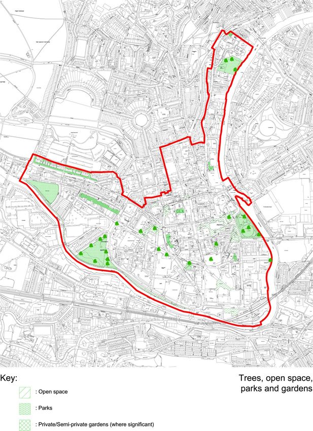
Map of trees, open space, parks and gardens.
Annexe 2. Context 52
Annexe 3. References 52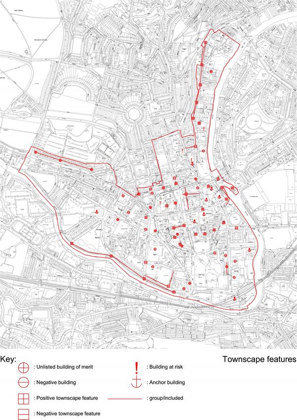
1. Introduction and description of the Character Area

             General description and form

             This document is a character appraisal for the City Centre Character
             Area of Bath Conservation Area.

             Bath City Centre Character Area sits on a shallow ridge sloping
             down to a meander of the River Avon; its form is a central polygon
             extending from Bath Spa railway station in the south to George
             Street in the north. From this polygon two arms extend roughly in a
             ‘V’ shape: one following the Avon north-west to Norfolk Crescent, the
             other following it in the opposite direction north almost to Cleveland
             Bridge.

             Bath City Centre includes the walled mediaeval city overlaying a
             Roman settlement centred on the natural hot springs. It therefore
             contains the Roman Baths and Pump Room, Bath Abbey, Pulteney
             Bridge and the main shopping areas from Southgate to Milsom
             Street and Broad Street. These lend the area its strongest defining
             character, with a dense and complex mix of mediaeval and later
             urban buildings of varied types and architectural styles; they overlay
             Roman and earlier archaeology. It also includes outer central areas
             such as Kingsmead, Manvers Street and the Walcot Street district
             which originated as a Roman settlement outside the walls. The entire
             Character Area is at the heart of the World Heritage site.

             City Centre Character Area and the World Heritage Site

             Core values and significances of Bath:
             • Bath is a World Heritage Site, the only entire city in Britain to be so
             designated
             • It is not a museum but a living city
             • It has a remarkable degree of visual homogeneity
             • Authenticity of the Site is of the essence, and its preservation and
             enhancement should be key criteria for all new development
             • Its complex and delicate hierarchy of interrelated urban spaces,
             landscape and architecture could be easily disrupted by overbearing
             or misinformed development. Its complex and delicate hierarchy
             of interrelated urban spaces, landscape and architecture could be
             easily disrupted by overbearing or misinformed development and by
             the accumulation of harm.

             Bath was inscribed as a World Heritage Site in 1987. The designation
             describes the city as “a masterpiece of human creative genius whose
             protection must be the concern of all”.

             Bath was inscribed as a World Heritage Site in 1987. The designation
             describes the city as “a masterpiece of human creative genius
             whose protection must be the concern of all”. The World Heritage
             Site designation was awarded for its Outstanding Universal Value
             (OUV) with six attributes:

             1. Roman archaeology

             Many of the City’s Roman remains are centred around the Roman
             Baths. These include the archaeological remains of the Roman
             temple of the Goddess Sulis Minerva and the extensive bathing

City Centre Character Area Appraisal                                                 1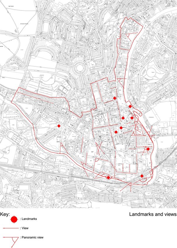
complex. The Roman town of Aquae Sulis was a walled settlement.
            Beyond the city wall are Roman and Iron Age remains including
            hill forts, field systems and villas, demonstrating the extent of the
            settlement. The road system and Roman street plan influenced the
            Mediaeval and Georgian layout.

            2. Hot springs

            Bath’s hot springs are the only ones in Britain, producing 250,000
            gallons of water every day. There are three main springs - the King’s
            Spring, the Hetling Spring and the Cross Bath Spring. They have
            been central to every stage of the city’s development, creating a
            unique social history and culture where the waters are central to
            healing and recreation.

            3. 18th century architecture

            Neo-classical architectural style dominates in Bath. Architects
            including John Wood the Elder, John Wood the Younger, Robert
            Adam, Thomas Baldwin, John Palmer, John Eveleigh and John
            Pinch , followed Palladian principles to build houses, public buildings,
            bridges and churches. The Georgian arrangements of crescents,
            squares, The Circus and terraces form iconic, internationally
            recognisable structures. The widespread use of local limestone and
            the uniform scale and height of buildings contribute to Bath’s beauty
            today.

            4. 18th century town planning

            In the 18th century Bath was re-invented as a fashionable health
            resort, expanding dramatically beyond its city walls. Mediaeval streets
            were transformed into a spacious and beautiful classical city, where
            architecture and the natural landscape complemented each other.
            Uniformity of design was enhanced with the universal use of honey-
            coloured Bath limestone. Innovative forms of town planning including
            squares, crescents and The Circus were introduced. Attractive views
            and vistas were deliberately created. Bath’s Georgian town planning
            influenced subsequent developments in the UK and beyond.

            5. Green setting

            The City of Bath lies within a hollow of the hills. There are green views
            in every direction from the city centre. The countryside stretches
            right to Bath’s doorstep. The hilly, green landscape was exploited by
            Bath’s 18th century architects and developers, who created elegant
            terraces and villas on the slopes. The hills to the south of the city
            provided the oolitic limestone from which the city was built. Trees and
            woodlands populate the skyline, and lend natural beauty to the river,
            canal, parks and gardens. Open agricultural land on the edge of
            Bath is still used for grazing animals, just as it was by the Georgians.

            6. Social setting

            Bath’s Georgian architecture reflected 18th century social ambitions.
            The city was a destination for pilgrimage, and for playing out the
            social aspirations of fashionable spa culture. The social, economic
            and physical re-birth of the city as an internationally famous spa
            resort was largely due to three key characters: the architect John
            Wood the Elder, wealthy postmaster and stone entrepreneur Ralph
            Allen and Bath’s famous Master of Ceremonies Richard ‘Beau’ Nash.
            Visitors flocked to Bath. The list of famous and influential people
            who visited, lived in or wrote about the city is extensive. Customs
            and practices associated with ‘taking the waters’ were practiced and
            developed here. The fashion for promenading influenced the design
City Centre Character Area Appraisal                                                2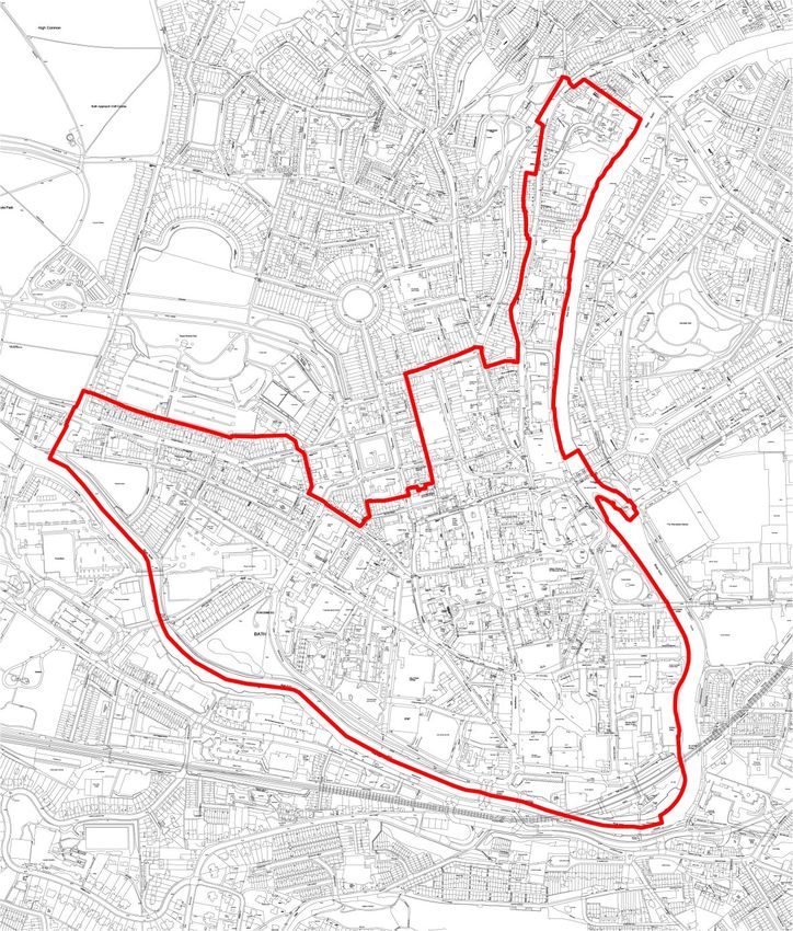
of Bath streets and gardens. The rules and etiquette governing polite
             society were embodied in buildings such as the Assembly Rooms
             and Pump Rooms.

             How does this Character Area contribute to the World Heritage
             Site?

             1. Contribution to Roman archaeology

             The Roman Baths sit at the centre of this Character Area. They are
             the raison d’être for the wealth of Roman archaeology in the city, and
             for its position at the centre of a network of Roman roads connecting
             London, Exeter and Lincoln. Villas and settlements along the Avon
             valley and around Bath were sited near the road network converging
             on the Baths of Aquae Sulis. The sites of the Roman walls and
             gates are still discernible, as rebuilt in the 9th century and later. The
             Roman Fosse Way crossed the west end of this Character Area on a
             line just east of Marlborough Lane, through the site of the former car
             showroom on Upper Bristol Road, crossing the Avon at the western
             end of Nelson Villas to pick up the line of Brougham Hayes.

             2. Contribution to Hot Springs

             The hot springs rise at three points within this Character Area making it
             crucial to the WHS designation. Without the hot springs, Bath’s entire
             history and topography would have followed a different course. The
             King’s Spring feeds the Roman Baths. Historically the Cross Spring
             fed the Cross Bath, Hetling’s Spring fed the Hot Bath. The New Royal
             Bath (opened 2006, trading as Thermae Bath Spa) takes water from
             all three, and has revived the social and architectural presence of
             the Spa for the 21st century. The newly opened Gainsborough Hotel
             also draws water from all three

             3. Contribution to 18th century architecture

             The most famous ‘set-piece’ architecture of Georgian Bath – Queen
             Square, The King’s Circus and Royal Crescent included – is in the
             Lower Lansdown and Camden Character Area, north-west of the
             pre-Georgian city. However, the City Centre contains key Georgian
             architecture such as the Pump Room and Guildhall, the Cross Bath,
             Robert Adam’s Pulteney Bridge and Jelly & Palmer’s church of St
             Swithin, Walcot. Public buildings, bridges and churches predominate
             as expected in this location, and for the same reasons tend to be
             bigger and higher than the surrounding buildings. They tend to be
             stand-alone buildings dictated by pre-Georgian locations and usage.
             Uniquely in this Character Area may be seen the few Georgian
             survivors of the period before John Wood, i.e. c.1700-1725; Baroque
             houses in Abbey Churchyard, Broad Street, Green Street and around
             Kingsmead Square. John Wood the Elder’s townscape around North
             Parade and South Parade is the only place in this Character Area
             where his innovation at Queen Square was carried through – the
             translation of Palladio’s palace designs to palace-fronted terraces
             formed of a large number of individual houses. All these buildings
             are of Bath limestone, maintaining Bath’s homogenous honey-
             coloured townscape.

             4. Contribution to 18th century town planning

             The dense fabric of pre-Georgian Bath limited the opportunities for
             grand planning and extended redevelopment in the 18th century.
             Nevertheless this Character Area bears much evidence of Georgian
             re-planning and rationalisation. The Bath Improvement Act of 1789
             was responsible for the creation of Union Street, New Bond Street
             and Bath Street, and swept away a tangle of mediaeval alleys in

City Centre Character Area Appraisal                                                 3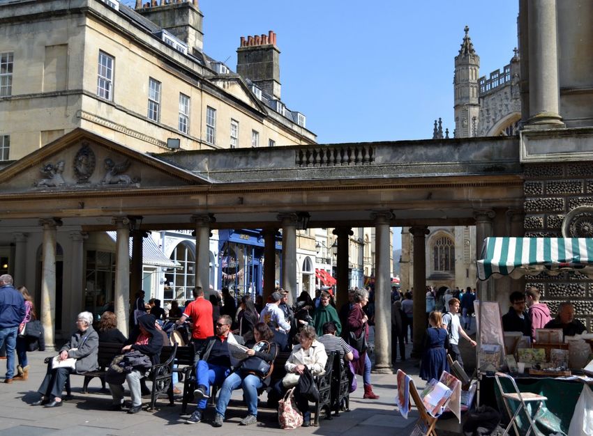
the south-west quarter of the walled town. Formal symmetrical
             layouts directed the eye to public buildings and important focal
             points reached via shady colonnaded walks. These changes were
             essential to ensure the central streets achieved something of the
             same elegance and splendour of the new residential districts, making
             an appropriate setting for fashionable and aristocratic society visitors
             to the Spa. Bath’s town planning was the deliberate creation of an
             environment in which fashionable society could see and be seen
             during the formalised round of promenades and visits to the spa,
             concerts and assemblies.

             5. Contribution to green setting

             The City Centre affords views out to the surrounding hills at almost
             every turn: from Westgate Street and Cheap Street a narrow slice
             of the densely wooded horizon at Claverton is visible; from Grand
             Parade, Lansdown with Camden Crescent snaking beneath its brow.
             Look south down Stall Street and the trees of Beechen Cliff rise
             up beyond the shops. From Parade Gardens, the view east looks
             across sports fields which were once the mediaeval water meadows
             of Bathwick, surviving unbuilt since prehistory. The hilltops around
             Bath are rarely more than a mile from the Abbey, offering spectacular
             views onto Bath’s centre. Few cities in the world may claim such an
             intimate relationship with their surrounding landscape.

             6. Contribution to social setting

             The Character Area includes the town houses of two of the three
             men who forged the Georgian reinvention of Bath: Ralph Allen and
             Beau Nash. That of John Wood the Elder (No 9 Queen Square) is
             just outside this Area. The Pump Room remains (as it was in the 18th
             century) the epicentre of the visitor’s experience of Bath. The social
             functions around ‘taking the waters’ are embodied in the Roman Baths
             complex and in the revived spa at the New Royal Bath. Harrison’s
             Walk, now Parade Gardens, and North and South Parades reflect
             the social activity of promenading in a formal manner to see and be
             seen by Bath society. Even the Abbey was a place for observing ‘the
             company’; its numerous memorials commemorate society figures for
             whom the waters were not an effective cure. The grand 18th century
             terraces, and the many humbler ones, were mostly built as lodgings
             for visitors rather than for permanent residents.

City Centre Character Area Appraisal                                                4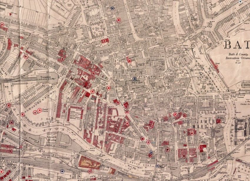
City Centre Character Area Map

City Centre Character Area Appraisal                               5
2. Summary of key characteristics

             The complex City Centre Character Area is described under six
             sub-areas: the walled city; Walcot; Southgate and Manvers Street;
             Kingsmead to the river; Milsom Street and its surrounds; and finally
             Green Park to Norfolk Crescent.

             The walled city:
             • A walled city of Roman origin centred upon the Roman Baths
                complex and Bath Abbey
             • A small-scale and intimate central district within the lines of
                Roman and Mediaeval walls
             • Some mediaeval buildings and street lines survive beneath the
                Georgian redevelopment
             • The fine Late Perpendicular Abbey church dominates with its
                imposing crossing tower
             • Three buildings mark the turning points of the spa’s fortunes: the
                late 18th century Pump Room, the late Victorian Empire Hotel,
                and the Thermae Bath Spa at the turn of the 21st century
             • Two further hot springs west of the Pump Room feed the Cross
                Bath and Thermae Bath Spa
             • The three springs are linked by the splendid Neoclassical
                colonnades and Georgian shopfronts of Bath Street
             • A busy commercial and shopping area around the axis of Union
                Street, Stall Street and Southgate Street
             • Westgate Street and Cheap Street cross the north-south axis,
                with the High Street, markets and Guildhall leading off east

City Centre Character Area Appraisal                                            6
•    A south-west quadrant of quiet lanes and alleys and a hospice of
                  Mediaeval foundation
             •    A tranquil south-east quadrant around Abbey Green and North
                  Parade Passage with some pre-Georgian survivals

             The walled city is centred upon the dual axis of the Roman Baths
             complex and Bath Abbey. The Abbey is Bath’s centre point, with its
             associated public spaces west and south framing the Pump Rooms
             and Baths complex. Georgian and earlier buildings cluster around
             Abbey Churchyard and Abbey Green, still with a pleasing blend of
             shopping, commercial and residential use. Then the busy axis of
             Stall Street, the heart of Bath’s shopping district, running in a broad
             swathe down the slope. Westgate Street and Cheap Street form a
             cross-axis, narrow and bustling. All this overlays mediaeval and in
             parts Roman street lines. High Street runs from the Abbey to the
             site of the north gate, with shops on the west and the splendid
             Neoclassical Guildhall and covered market behind. East of the
             Abbey, hard to classify because so out of character with everything
             else (and yet so quintessentially Bath), sits the huge bulk of the
             Empire Hotel, reminiscent of the last gasp of the spa before the 20th
             century impinged. Lower and Upper Borough Walls mark the limits
             of the mediaeval city, with a short section of wall surviving at the
             latter. The south-west quadrant of the walled city is quite separate
             in character, with narrow lanes following mediaeval lines around St
             John’s Hospital, early Georgian and much altered, but on its 12th
             century site. Nearby the second and third of Bath’s hot springs rise,
             feeding the Georgian Hot Bath, the Cross Bath and the new Thermae
             Bath Spa which has revived the spa’s fortunes. These are linked with
             Stall Street by the splendid formal composition of Bath Street with its
             quadrant ends and colonnaded walks. The character is again quite
             different south of York Street, where Abbey Green forms a secluded
             square around its magnificent plane tree, with narrow lanes and
             alleys leading east towards Terrace Walk.

             Walcot:
             • A narrow linear area north of the city centre between the Avon
                and rising ground to the west
             • Of Roman foundation, it was an extra-mural trading and industrial
                settlement on the approach road to the Bath’s Roman north gate
             • Much rebuilt in Georgian times, with shops and houses of
                middling status
             • Recently revived after mid-20th century decline and planning
                blight
             • Its quirky and independent character encourages small shops
                and businesses

             Walcot is a narrow linear area north of the city centre, squeezed
             between the River Avon and the rising ground to its west. It is formed
             only of Walcot Street with its fringe of lanes, alleys and rear courts
             down the slope eastwards to the river bank. It began as an extra-
             mural Roman settlement for artisans and trading, grouped along
             a spur road giving access from the London road to the main north
             entrance to Aquae Sulis. Ladymead House was in the late 17th
             century a large house for a gentleman, with gardens sloping to the
             river, and survives with many later changes. Walcot Street was much
             rebuilt in the Georgian era and many of the shops at its south end
             date from that time, with some 19th century additions. It declined in
             the mid-20th century with the threat of demolitions for a road tunnel
             that never arrived, and has since been revived again, maintaining its
             quirky and independent character with small shops and cafes among
             residential infill.

             Southgate and Manvers Street:
             • Southgate Street marks the Medieval southern entrance to Bath
                from the Old Bridge

City Centre Character Area Appraisal                                               7
•    At the north end of Manvers Street are South Parade, North
                  Parade and their linking terraces, by John Wood the Elder
             •    The rest of the area developed intensively in the 19th century
             •    The railway station (1840) increased the markets for hotels, inns
                  and shopping
             •    Manvers Street was laid out as the major approach to the train
                  station
             •    Heavily bombed in 1942, the area was redeveloped after 1950
                  with a shopping precinct and bus station
             •    These were demolished for the Southgate Precinct (2007-9) and
                  Brunel Square

             Southgate and Manvers Street form the southern fringe of the city
             centre. Southgate Street, now a busy street of modern shops, was the
             mediaeval street linking the Old Bridge (13th century or earlier) with
             the South Gate of the city. Building clustered around the bridge and
             adjacent quays, but major development on the former fields east of
             Southgate Street began only in the 19th century. Manvers Street was
             laid out as the southern continuation of Pierrepont Street to link the
             city and the railway station c.1840; the Argyle and Dorchester hotels
             at its southern corners are early survivors. Dorchester Street, Phillip
             Street and surrounds were heavily bombed in the Second World War,
             redeveloped in the 1970s as Southgate shopping centre with the bus
             station and car park adjacent. All this was demolished c.2007 for the
             Neo-Georgian Southgate precinct and a new Modernist bus station
             south of Dorchester Street. At the same time Brunel Square was
             created west of the Railway Station, and incorporates historic vaults
             once used for coal storage.

             Finally, at the north end of Manvers lie Pierrepont Street, North
             Parade, South Parade and Duke Street, all part of John Wood
             the Elder’s ‘Royal Forum’ scheme (1740-43). These fine Palladian
             terraces were part of an intended scheme of enormous scale but
             never built. Their broad pavements designed for promenading are
             raised high above the river at their east end - the best place in Bath
             to appreciate the extent of Georgian work to raise the new city above
             the flood level.

             Kingsmead:
             • Originated as an area of artisan housing and trade allied to Broad
                Quay on the Avon
             • Kingsmead Square was laid out in the early 18th century with
                Baroque houses
             • Beauford Square, Avon Street and Milk Street followed by c.
                1740
             • Heavy bombing in 1942 of housing stock already jeopardised
                by repeated flooding led to almost complete post-war clearance
                near the river
             • Some Baroque survivals in Kingsmead Square and good
                Neoclassical terraces at St James’s Parade
             • Bleak post-war redevelopment for coach and car parks and the
                Bath College campus

             The Kingsmead area lies south-west of the city centre; it covers
             everything from Kingsmead Square southward to the river, contained
             by Green Park Road and Charles Street to the west and Beauford
             Square, Westgate Buildings and St James Parade to the north. The
             character here is hugely varied, having had much artisan housing
             which was subject to early demolition, severe repeated flooding
             which led to dilapidation of the building stock, industrial decay as
             Bath’s small quays went out of use, and the heaviest concentration
             of Second World War bombing. Kingsmead Square and Beauford
             Square have some of the earliest buildings, early 18th century
             Baroque in character, though much here was lost to bombs and

City Centre Character Area Appraisal                                               8
post-war demolition. St James Parade and parts of Monmouth Street
have the few remaining coherent examples of mid and later Georgian
housing (c.1740-80). Avon Street and Milk Street began c.1740 as
streets of artisan housing leading direct from Kingsmead Square to
the river: now entirely dominated by the 1960s Bath College buildings
and the awkward and bleak car and coach parks to their south;
here the coherence of Georgian Bath is entirely lost. 1930s flats at
Kingsmead West and North face the river across Green Park Road,
where redevelopment is occurring for the second time since the
bombing of the late Georgian terrace of Green Park East. Disruptive
post-war buildings continues around Charles Street and James
Street West; the reviled Kingsmead House has been demolished.
The ‘unbelievably perverse’ former Telephone Exchange with its
overpowering slate-hung upper floors has not.
Milsom Street and its surrounds:
• A late piece of infill (c. 1761) between the walled city and John
Wood’s new town to the north-west
• The big lodging houses were being converted to smart shops by
c. 1800-20.
• A fine palace fronted composition by Thomas Baldwin at
Somersetshire Buildings
• Broad Street, a Mediaeval suburb runs parallel to Milsom Street
and to its east, with charming Georgian and gabled buildings of
c. 1700, some on Mediaeval cores
• Green Street was laid out c. 1717 with vernacular Baroque
houses, now a narrow shopping street
• Attractive stone-paved side streets (e.g. Queen Street) west of
Milsom Street
Milsom Street and its surrounds lie directly north of the main shopping
axis of the walled city, and are now a continuation of it. But this is
misleading, for the area was open fields east of Queen Square until
Milsom Street was laid out c.1761. Originally intended as smart
lodgings for spa visitors (General Tilney in Austen’s Northanger Abbey
lived here), it linked the northern boundary of the city with Wood’s new
developments north of Queen Square – Gay Street, George Street
and The Circus. The present character, that of a very smart shopping
street, was well established by the early 19th century. On the east side
is a rare example of palace -fronted Georgian housing that interrupts
the standard facades: Somersetshire Buildings by Thomas Baldwin
(1781-3), with a bowed centre and attached porticoes at each end.
The side streets near Milsom Street vary from gabled housing with
Baroque details in Green Street, laid out c.1717, high Greek Revival
and Victorian shops in Quiet Street, to the back lanes such as John
Street and the delightful enclave of Queen Street, cobbled and with
intact 18th century shop fronts. Broad Street, running north up the
slope parallel to Milsom Street, pre-dates it by half a millennium:
an early mediaeval extra-mural suburb outside the North Gate. It is
narrow and curves slightly as it rises, with the low gabled Saracen’s
Head (1713 and earlier) and more Baroque three-storey houses
like those in Green Street. Behind the Georgian street fronts are
still some mediaeval buildings; Milsom Place, with new shops and
restaurants knitted deftly into the dense grain behind historic street
fronts exemplifies the recent development and allows glimpses of a
few mediaeval fragments behind Broad Street.
Green Park to Norfolk Crescent:
• A wedge-shaped area at the far west of the Character Area,
mostly developed between c. 1780 and 1820.
• Green Park is a spare Neoclassical terrace of which the twin was
lost to bombing
• Green Park Station (c. 1868) now Sainsbury’s supermarket,
demonstrates Georgian Bath’s influence on Victorian architecture.
• New King Street and Great Stanhope Street extended the
City Centre Character Area Appraisal 9Georgian town westward to end at the fine curve of Norfolk
Crescent (c. 1810-20)
• A limited number of bomb gaps and redeveloped sites amidst the
Georgian survivals epitomise the area’s character
Lastly is the wedge-shaped western extremity of this Character
Area, bounded on the south by the curving River Av`on, by Green
Park and Charles Street in the east, Monmouth Place, Charlotte
Street and Crescent Gardens in the north as far as the junction with
Marlborough Lane. The spare Neoclassical terrace of Green Park is
only half of the original conception, its pair to the east having been
bombed in 1942. They framed the triangular open space of the same
name. Adjacent is Green Park Station, the Midland Railway terminus
of c.1868, a fine demonstration of how Victorian Bath adapted to the
Palladian spirit of the place, and now restored. Markets and other
events now occupy the glass and iron station building. Through
the centre of the area run the west end of James Street West, with
some cottages, and former mews buildings now in business use. It
is decidedly not grand, yet still in the spirit of Bath which can lurch
from planned Georgian formality to humble back streets without a
moment’s notice. Parallel to the north is New King Street, plain Late
Georgian with pleasing details, though disrupted by 1960s infill on a
bomb gap. Lastly Great Stanhope Street leads west to the spare and
elegant curve of Norfolk Crescent (c.1810-20), the most westerly
major development of Georgian Bath, framing a broad triangular
lawn. Charlotte Street, a connecting diagonal from Queen Square
to Upper Bristol Road, was laid out c.1836, completing the street
pattern in this area.
City Centre Character Area Appraisal 103. Historic development
Physical influences – geology, land form and drainage pattern
The largest part of the area south of Monmouth Place, Monmouth
Street and Westgate Buildings is alluvial river deposits. The southern
boundary of the old city was at the edge of this deposit and the lower
gravel terrace, which is again a river deposition feature. The upper
part of the city centre including the majority of the historic core is built
upon Lower Lias Clays.
The city centre lies upon a broad but shallow ridge that runs
approximately north west to south east. The slopes run down to
the river on either side. There are no natural open water features
in the area although the River Avon forms the southern and eastern
boundary of the area.
Historical influences
Bath’s history is among the best documented of any British city.
This document attempts to give a summary history with references
to relevant in-depth reading. A more detailed but very readable
illustrated account of Bath’s development and architecture is available
in Michael Forsyth’s Bath (Pevsner Guides, 2003), pp. 3-50.
Pre-Roman and Roman settlement
It is known that there was Iron Age settlement at Bathwick Street and
doubtless elsewhere in the area. Some of these sites (as at Bathwick
Street) were colonised and re-developed in early Roman times.
At the time of the Roman occupation of Britain under Aulus Plautius
from AD 43, Aquae Sulis did not exist – it was established only c. AD
60 - 75. Before this a Roman road from London was made westward
via Calleva (Silchester) towards a port at Abonae (Sea Mills, Bristol).
The road entered the Bath valley along London Road, skirting north
of the marshy ground and the hot springs via Guinea Lane and along
Julian Road. Here there was a junction; the Fosse Way cut south
through Royal Crescent and Marlborough Lane, forded the Avon east
of Victoria Suspension Bridge and continued south. The road to Sea
Mills cut west via Weston and Swineford towards Bristol. There was
a fort in the valley, possibly at Bathwick. Settlements were scattered
throughout the valley.
Twenty years or so after the occupation, the attraction of the hot
springs at Bath led to the establishment of a small walled town
called Aquae Sulis. From the London road to the north a secondary
access street was laid out along the line of Walcot Street. Service
settlements for trade, crafts and industry existed at Bathwick, Walcot,
and seemingly on the allotments west of Marlborough Lane; there
may have been others. There was no bridge at the present Churchill
Bridge site; Southgate Street is post-Norman Conquest.
The Roman town and Baths
The Baths complex was functioning by about AD 75, with a temple
on a podium nearby to the north. The temple was surrounded about
50 years later by a rectangular colonnaded precinct. Sulis Minerva,
the presiding deity, was a conflation of Roman Minerva with the
City Centre Character Area Appraisal 11Celtic Sulis previously associated with the springs; the spring was
also the focus of votive offerings. The waters were covered by a brick
vault and controlled by means of a large lead-lined reservoir. A great
drain took surplus water eastward, where it probably poured across
the marshy ground into the Avon. The Baths were simply built but of
massive construction, providing a suite of heated steam rooms and
the Great Bath which was probably covered. From the 2nd to the
4th century there were numerous extensions and refinements to the
Baths. The curative power of the waters was as important in Roman
times as it was later. Earth ramparts and a ditch were constructed on
the lines of the mediaeval walls possibly in about AD 192-6 and later
faced with masonry, though evidence for a full circuit of defensive
gates and towers is lacking.
The town within the walls contained other public buildings but little
housing. Its small size (24 acres) suggests it may not have had the
administrative and judicial functions of other regional towns which
ranged in size from 45 to 240 acres. There was seemingly a second
circular temple and a theatre, the latter possibly under Westgate
Street. The main residential area was probably at Walcot and a
cemetery straddled the line of the London road. Early settlement
around Bath consisted of farms and industrial sites. Villas seem rare
until c. AD 270 after which there was a proliferation of great courtyard
residences (Wellow, Keynsham, Box, Wraxall etc), possibly because
of political turmoil and the sale of imperial lands to raise cash. Villas
existed closer to the town at Marlborough Lane, Sion Hill, Wells
Road, Norfolk Crescent and Bathwick.
The Roman withdrawal from Britain occurred in stages between 383
and c. 410, working roughly north-west to south-east. Many villas
around Bath were ransacked and burned by Irish raiders between c.
AD 350 and 370. Whether Bath was attacked is not known but by 400
the temple colonnade was demolished and the Baths were declining
through flooding and lack of maintenance. When the complex fell into
disuse is not known. Walcot survived as a residential and possibly
trading area, with a high status burial of the 5th century known.
This community finally fell to the Saxons in AD 577. An 8th century
Saxon poem possibly referring to Bath describes ruinous baths over
a hot spring with a circular pool, shattered buildings and foundations
surrounded by a crust of mud. A convent existed in Bath at 675, and
a monastery of St Peter (forerunner of Bath Abbey) by 757. Nothing
is known of the Saxon fabric but it was seemingly on the same site as
the present church. The significance of the priory church is evident
in the fact that it was chosen for the Coronation of Edgar, first King
of all England, in 973.
King Alfred probably rebuilt Bath in the late 9th century, aligning
the walls and the south, west and north gates on their Roman
foundations. He replanned the streets almost obliterating the Roman
layout. The line of Westgate and Cheap Street dates from this time
and the market place has become the High Street. North of Westgate
Street regular blocks were developed with lanes running north-south.
To the south, the Abbey precinct occupied much to the east of the
line of Stall Street, while the ruins of the Baths and the two springs
to the west modified the street plan. In 1091 the Abbey became the
Cathedral until 1244, and in the 1090s Bishop John of Tours began
reconstructing the Saxon church on a vast scale. He also extended
the precinct northward and rebuilt what became the King’s Bath. His
Bishop’s Palace was established on a site extending from Abbey
Green west towards Stall Street which was probably laid out shortly
after 1091.
A bridge on the site of Churchill Bridge existed by the early 13th
century. Southgate Street was developed linking the bridge with
the town via the south gate. The tangle of lanes around the Cross
Bath and Hot Bath was known as Bimbery; it may have served
the Abbey’s lay community and became associated with medicine
and almshouses. St John’s Hospital survives, founded c.1180. The
City Centre Character Area Appraisal 12mediaeval town was not densely built, especially south of the Abbey.
Speed’s map of c. 1575 and Gilmore’s map of 1694 (with pictorial
representations of key buildings) give a good idea of the layout and
the appearance of the town. Of the gates, only the 14th century arch
of the East Gate survives in an alley beside the Empire Hotel. At
Broad Street, outside the North Gate, a mediaeval suburb grew up
around the church of St Michael (twice rebuilt since); pre-Georgian
structures survive behind many facades. The Roman settlement
around Walcot Street became an extra-mural settlement, with some
of the same character of artisan production and trade, and shops by
the 14th century. Many buildings around Broad Street are refronted
mediaeval structures, with occasional fragments such as a timber-
framed gable wall visible at the backs.
Bath’s late mediaeval wealth was based largely on the wool trade
which flourished in the well-watered valleys of west Wiltshire and
east Somerset. The Abbey was rebuilt from 1502 by Bishop Oliver
King, and was largely complete when the Abbey was dissolved in
1539. The huge Norman east end was demolished; the present
church occupies the site of the old nave. Timber-framing was
the standard for housing until the early 17th century when stone
buildings became more usual – Sally Lunn’s house and its neighbour
in North Parade Passage are rare survivors of c. 1622. The lure of
the waters was not forgotten, for in the 17th century the practice of
bathing in the waters as a cure flourished. Drinking from the springs
was a Georgian innovation. The Baths were essentially mediaeval
structures, much altered and somewhat untidy in appearance,
and the bathing experience raucous, unstructured and sometimes
bawdy. In 1688 Mary of Modena gave birth to a son after bathing in
the Cross Bath (the waters were said to cure infertility) and the spa’s
popularity increased.
Georgian Bath, c. 1700 - 1830
Two more Royal visits by Queen Anne in 1702 and 1703 accelerated
Bath’s fashionability and social conventions began to develop around
the Baths, with the first Pump Room (on the present site over the
Roman temple precinct) built in 1705. Gabled houses of the early
18th century survive in Broad Street (Saracen’s Head, altered 1713).
Green Street was laid out on a bowling green in 1717, with some
Baroque detailed houses surviving. Pressure of space and steadily
increasing numbers of visitors pushed new development outside
the old walls, and in 1727 Kingsmead Square was laid out beyond
the west gate; Beauford Square followed in the 1730s. The need by
this time was for lodging houses to accommodate spa visitors who
arrived for the season.
It was due to three men that Bath was transformed from health resort
to pleasure resort from the 1720s: Ralph Allen, Richard ‘Beau’ Nash
and John Wood the Elder. Allen was Bath’s postmaster and made
a fortune improving the national postal service; he bought stone
quarries at Combe Down and was looking for means to promote the
business. Beau Nash became Master of Ceremonies at the Pump
Room in 1704, and dictated a system of etiquette, timing, dress and
behaviour that made the Spa the height of fashion, its Winter Season
attended by the cream of British society. John Wood was a young
architect who brought to Bath the Neo-Palladian style promoted
by the 4th Lord Burlington in the 1720s, providing up-to-date and
fashionable squares, terraces and public buildings in which visitors
partook of the new social round. All were built of Ralph Allen’s stone.
His first major development was Queen Square (1728-36), with
related development in Wood Street, Chapel Row and north in Gay
Street.
Wood’s great innovation was to treat a terrace as a unified composition
like a palace-front, giving the illusion that each residence was far
City Centre Character Area Appraisal 13grander and larger than it could appear alone. He defined types of
layout – in fact, early town planning – with squares for meeting and
socialising in public, parades (broad paved walks fronting terraces) for
the formal walks where visitors greeted and displayed their presence
and circuses for the exhibition of sports (only one was ever built).
North and South Parades, Duke Street and Pierrepont Street were
built on fields called the Ham in 1740-3 as part of Wood’s planned
‘Royal Forum’. A square of 1,040 by 624 feet was to cover the whole
of the Ham area and span the River Avon which was to be canalized
as a formal water-garden bisecting the square. The two parades
were designed for the weather – in the summer North Parade offered
shade, in the winter South Parade caught any sunshine.
The Grand Forum was never completed and Wood’s ambitions
turned to the developments north-west of the old city, on higher
slopes above the flood level and offering healthy breezes. Building
expanded as far as Milsom Street, The Paragon, Rivers Street, Brock
Street and Royal Crescent by the 1760s, and these areas offered the
most desirable lodgings in Bath. The population increased from c.
2-3,000 in 1700 to 15,000 by 1770. By this point, the area covered by
the City Centre Character Area was almost fully developed and later
building took place further north (Lansdown, Camden etc) and east
of the river to the Bathwick estate. Many Georgian developments
were built on vaults to raise the street levels above the floods, to
minimise the effect of slopes and to provide basement service rooms
in the houses; this has a specific impact on new development as the
integrity of historic vaults and services in them must be considered.
The artificially raised street level over much of the Georgian city is
characteristic of Bath.
Public building in the city centre was limited. The Pump Room of
1705 was enlarged in 1751, rebuilt 1790-5. The Lower Assembly
Rooms (Terrace Walk) were built in 1709 (its successor demolished
in 1933). Thomas Baldwin’s Guildhall replaced a predecessor of
1626-7 that sat in the centre of High Street. Pulteney Bridge was
planned in the 1760s. St Michael’s church, Broad Street, was rebuilt
in the 1730s and St James near the South Gate in 1768-9. Behind
Milsom Street sits the beautiful Octagon Chapel (1766-7), and St
Swithin, Walcot was built 1777-80.
It must be remembered that wealthy visitors required household
servants, grooms, launderers, house furnishers, blacksmiths, tailors
and jewellers: the providers of these and a thousand other services
lived in poorer quarters of artisan housing or worse. Avon Street,
Corn Street and Milk Street were built from c. 1735 on the flood plain
north of the Avon, and other lanes, cottages and mews buildings
wove through the smart terraces and squares. These developments
were prompted by the Avon Navigation Scheme completed in the
late 1720s. This led in turn to Bath’s growth as an inland port trading
mainly through Bristol and served by warehousing at Broad Quay.
The area from Avon Street to Broad Quay remained a busy industrial
area into the 20th century. Much here was demolished in the 20th
century leaving the polite housing less intelligible historically. Walcot
Street maintained its mixed character: shops, taverns, industrial
workshops in rear yards, and some polite terraces (e.g. Chatham
Row, c. 1767) rubbed along cheek-by-jowl. The relatively poor
housing east of Southgate Street was subject to flooding and cleared
after heavy bombing in 1942. Manvers Street was not laid out until
the 19th century, and the land to its east remained as garden plots,
the last vestige of Bath Abbey’s orchards.
1800-1900
By 1800 or soon after, Bath’s heyday as the nation’s spa resort was
fading. Bath attracted more middle-class visitors, and permanent
residents’ took over from seasonal lodgings. Taking the waters never
City Centre Character Area Appraisal 14ceased but it waned significantly. These trends are reflected in its
buildings, with fewer new public buildings in the city centre and the
creation of genteel suburbs of Greek Revival, Gothic or Italianate
villas, e.g. at Bathwick Hill, Lansdown, Lyncombe, Sion Hill etc.
Picturesque ideals of Tuscan hillside landscapes and the idea of ‘rus
in urbe’ suited Bath’s topography and social climate well. The national
pause in building caused by the French wars (1793 – 1815) and the
consequent economic collapse affected Bath too. The collapse of
the Bath Bank precipitated many bankruptcies, although building did
not cease entirely and resumed shortly after 1800.
In the city centre 19th century building types are predominantly
shops and arcades (e.g. The Corridor, 1825, among the earliest
shopping arcades in the country outside London), banks, hotels and
commercial buildings, schools, churches and chapels. Conversion
and infill predominate over new layouts. Royal Victoria Park and
Henrietta Park were laid out in the early 19th century, but there
were no opportunities for such broad landscapes in the densely
built centre. The Victorian Gothic Revival was muted in Bath by the
strength of its classical tradition, but there are individual examples
such as St Michael (rebuilt 1834-7) and St John’s RC Church (from
1863). Tudor Gothic was used for Brunel’s Great Western Railway
station (opened 1840) and associated structures such as the
viaduct. Occasionally Jacobean Revival is explored, e.g. the Blue
Coat School, Sawclose (1859). In the same year the same architects
extended the Rheumatic Diseases Hospital nearby in pure Palladian
style: Bath architects responded strongly to the ‘genius of the place’.
In the later 19th century, the Corporation expanded dramatically
as a mechanism to manage the city and its population’s needs.
Architecturally, Bath tended to build upon its Georgian heritage, and
much that appears to be Georgian is in fact a century or more later.
New Baths and a large hotel on Stall Street were provided in the
1860s; revival was accelerated by the rediscovery of the Roman
Baths beneath later structures in the 1870s. This led to a long period
of excavation and controversy about how best to conserve them, or
not. Spa visiting increased dramatically to experience a final heyday
c. 1890-1910. To this period belong J.M. Brydon’s new Concert
Room, his Guildhall extension and Victoria Art Gallery, and C.E.
Davis’s bombastic and high Empire Hotel (1899). Fine 19th century
shopfronts are a special feature of this Character Area (e.g. Jolly’s,
Milsom Street, from 1879).
Bath since 1900
The period 1900-1940 saw infill development, often Neo-Georgian
and of high quality, e.g. the old Post Office, New Bond Street
(1923-7), the former Royal Mail Sorting Office (1935) off Manvers
Street, and the Forum Cinema (1933-4), Neoclassical without, Art
Deco within. Replanning included the clearance of the Literary and
Scientific Institution for a new road layout at Terrace Walk (1933).
Some clearance of substandard housing around Avon Street began
in the 1930s with new flats provided at Kingsmead. The Second
World War accelerated the process, with one weekend of intense
bombing raids destroying much in the city centre. Losses or areas
of severe damage include most of Kingsmead Street, James Street
West, Avon Street, Corn Street and Milk Street, Kingston Road
(Southgate Precinct site), St James’s church, Abbey Church House,
Green Park West, New King Street and one end of Norfolk Crescent.
Thankfully the Abbey, Roman Baths and Pump Room, Broad Street,
Walcot and the core of the centre from Stall Street north to Milsom
Street all escaped remarkably lightly.
Post-war rebuilding took several decades. Patrick Abercrombie’s
Plan for Bath (1945) proposed functional ‘zoning’, ring roads and
major new civic buildings, often sweeping away highly significant
architecture and townscapes. Lesser Georgian buildings were
entirely unconsidered, part of the prevalent attitude that only the
City Centre Character Area Appraisal 15great ‘set pieces’ mattered. The plan was almost entirely unexecuted
but the clearance of artisan quarters and of parts of the city centre
continued (e.g. the Harvey building, west side of High Street, 1964-
6). Southgate was rebuilt with an unattractive Bus Station and multi-
storey car park; Bath Technical College site at James Street West
and Avon Street replaced early 18th century artisan housing patched
with bomb sites. Walcot was blighted by a road tunnel proposed
in 1963 and not abandoned until the late 1970s. The significant
losses and failure to protect Bath’s heritage were distilled in Adam
Fergusson’s seminal book, The Sack of Bath: A Record and an
Indictment (1973). By the 1960s the Bath Preservation Trust was
pushing hard to prevent further destruction and slowly the tide began
to turn. The retention of the south side of Kingsmead Square (1969)
was symptomatic. From the mid-1950s soot-blackened Bath stone
was systematically cleaned, begining with The Circus.
Late 20th century developments in the city centre are varied. Walcot
Street has been revived as an area of independent shops often with a
quirky character. Owners report credibly that during the blight caused
by the proposed road tunnel, the city council as owner of some shops
inadvertently created a legal loophole allowing temporary tenants
to become freeholders, contributing to the area’s independent
character today. Redevelopment elsewhere has adopted Modernist
style (e.g. offices on the north side of Trim Street, shops west of
Barton Street) or traditional (e.g the Plummer Roddis block, south
side of New Bond Street, 1980s). The degree of understanding of
the classical language of Georgian Bath also varies: Seven Dials
shopping centre at Sawclose (early 1990s) display an intelligent
use of proportions, of the Tuscan order and details such as ramped
cornices to step down the slope. By contrast Southgate (completed
2010) has awkwardly proportioned or out-of-scale details and mixes
Palladian and Neoclassical motifs indiscriminately. A successful
overtly Modernist design of harmonious materials is the New Royal
Bath (Thermae Bath Spa, opened 2006).
Bomb damage map of city centre
City Centre Character Area Appraisal 164. Cultural influences
Bath’s status in the national social culture of the 18th century means
that it was visited by virtually everyone of high social standing, as
well as by many who were not. Thus it figures large in paintings,
letters, diaries, literature and artefacts from the 18th century and
indeed from other times. Because of the concentration of important
figures here, Bath was the coincidental setting for a disproportionate
number of discoveries, ‘firsts’ and great events.
Bath has attracted travellers, writers, artists and musicians for
centuries. They were drawn to Bath’s distinctive character, and
in turn, they contributed to the development of that character in a
multitude of different ways through their work.
The cultural perception of Bath has been dominated by three
principal components: Bath Abbey, the spa and its Hot Springs, and
the Georgian city and its landscape setting.
Bath has an international reputation for the quality of its architecture,
urban design, archaeology and landscape setting, recognised by
the city’s World Heritage Site status. The warm Bath stone of its
classical buildings and their Pennant stone pavements are the very
epitome of an English Georgian city.
Writers
A vast number of writers have contributed to the literature of and
about Bath. The Wife of Bath is among the best known and loved
characters of Chaucer’s Canterbury Tales. The Romantic poets
Wordsworth and Southey visited. Novelists who set their books in
Bath include Daniel Defoe, Henry Fielding, Fanny Burney, Tobias
Smollett, Charles Dickens and Jane Austen. About one third of
Austen’s ‘Persuasion’ and two-thirds of ‘Northanger Abbey’ are set
in Bath. In 1816 Mary Shelley wrote much of ‘Frankenstein’ here.
The eccentric collector and Gothic novelist William Beckford spent
his last years in Bath; Beckford’s Tower on Landsdown is now open
to the public.
Artists
Bath has always attracted artists to record its buildings and
landscapes. Over 160 artists worked in 18th century Bath. Of
these, 49 were landscape or topographical painters. Printmakers
documented over 1,100 views while cartoonists such as Thomas
Rowlandson and James Gillray satirised the human foibles of Bath’s
visitors. Gainsborough and Sir Thomas Lawrence were perhaps the
most famous portraitists to live and work in Bath. J.M.W. Turner, one
of the most celebrated painters of the 19th century, painted Bath
Abbey in 1793. The brothers Thomas and Benjamin Barker were
long time residents and members of a family of artists known as ‘the
Barkers of Bath’. The landscape painter John Nash, (1893-1977)
visited Bath in the 1920s, painting some urban scenes framed by
landscapes such as ‘Canal Bridge,’ ‘Sydney Gardens’ and ‘The
Suspension Bridge, Bath’. The devastation wrought by the Second
World War Baedeker blitz of April 25th – 27th 1942 was recorded
in a series of evocative scenes by war artists including John Piper,
Clifford Ellis, Leslie Atkinson and Norma Bull. Images of Bath have
been used in advertising including railway posters from 1908 to the
1960s. A good example is C H Buckle’s 1949 poster for British Rail
entitled ‘Pulteney Bridge.’
City Centre Character Area Appraisal 17Photographers
In the 1850s the Reverend Francis Lockey (1796-1869) used the
newly invented calotype photographic process to record the city,
its river and canal. The Bath Photographic Society’s fourth annual
meeting in 1893 proposed a “photographic survey of the district…
which would form a most valuable record for historians, antiquarians
and archaeologists.” (Bath Journal, 25 February 1893). The
architectural photographer Frank Yerbury (1885-1970) made a major
photographic record of Bath in the 1930s/1940s. W.H. Fox Talbot
(1800-77), who made the world’s first photographic negative in 1835,
lived at The Circus in the 1870s.
Film and theatre
Sarah Siddons, David Garrick, Richard Brinsley Sheridan and his
wife Elizabeth Anne Linley are perhaps the most famous Georgian
actors and playwrights who came here. Bath Theatre Royal maintains
its tradition of theatrical excellence begun in the 1760s. It often
previews West End shows and attracts world-class names. Bath is
frequently used as the setting for film. Recent productions include
‘Vanity Fair’ (2004), ‘The Duchess’ (2008) and the BBC adaptation of
Jane Austen’s ‘Persuasion’ (1995). William Friese-Greene, a pioneer
of motion pictures, had a studio in The Corridor.
Musicians
Music has been at the centre of the city’s life from the 1700s. Bath’s
Pump Room is home to the longest established band of musicians
in England, now known as the Pump Room Trio. “The Pump-Room
Band is one of the oldest and best establishments of this place; it
draws the visitor and inhabitant from the most distant parts of the
city to one general place of morning rendezvous; there long-parted
friends indulge in unexpected meetings, whilst the inspiring melody of
the Orchestra spreads a general glow of happiness around ....” (Bath
Herald, February 2, 1799). Composers associated with Bath include
William Herschel, composer and organist at the Octagon chapel,
Georg Friedrich Handel and Joseph Haydn. Herschel’s astronomical
studies are believed to have influenced Haydn’s Creation.
The Bath International Music Festival began in 1948 and established
Bath as a premier festival city. Past directors include Yehudi Menuhin,
Sir Michael Tippett and Joanna MacGregor. It has attracted world-
class performers and conductors such as Sir Thomas Beecham,
Rudolf Nureyev, Dame Margot Fonteyn, Vera Lynn, Jessye Norman
and Elisabeth Schwarzkopf. The Festival now extends to literary,
film children’s and fringe events, generating a huge influx of summer
visitors and a buzz of excitement about the city.
In his song ‘Solsbury Hill’ (1982) composer and performer Peter
Gabriel drew inspiration from the mystical landscape of a nearby Iron
Age hill fort and its view towards the city of Bath at night;
“Climbing up on Solsbury Hill
I could see the city light
Wind was blowing, time stood still…”
Sporting excellence
The University of Bath has nurtured athletic prowess for decades and
trained many of Britain’s Olympic teams and individual competitors
in recent years. Bath Rugby club, founded in 1865, built a reputation
since the 1940s as a team of national stature and in 1998 became
the first British club to win the European cup.
City Centre Character Area Appraisal 18Public life
Numerous public and political figures have stayed in Bath including
William Pitt the Elder, Edmund Burke, William Wilberforce, Admiral
Arthur Phillip (first governor of New South Wales), Field Marshal Earl
Roberts and Emperor Haile Selassie, who lived at Fairfield House
during his exile from Ethiopia (1936-41).
Discovery and innovation
Adelard (c. 1080-1160), known as the ‘first English scientist’, was
born in Bath. He studied in Europe and the Near East, bringing
important ideas on mathematics and astronomy back to mediaeval
Europe. William Herschel, also a talented composer, discovered
the planet Uranus at his home in Bath in 1781 and identified infra-
red radiation in 1800. Isaac Pitman (1813-97) devised his phonetic
shorthand system here in 1837 with symbols denoting sounds. The
Pitman Press operated in Bath until 2007. William Smith (1769-
1839), an engineer for the Somerset Coal Canal, established the
theory of geological strata. By 1815 he had produced a large scale
geological map of the whole of England, and became known as
the Father of English geology. In 1887 Adela Breton (1849-1923)
left Bath to explore cultures including Pre-Columbian civilisations,
acquiring a high reputation as an archaeological researcher and
recorder. James Dyson’s revolutionary bagless vacuum cleaner was
developed in Bath from 1978 and his hugely successful company
maintains close links with the city from its base in Malmesbury.
Leisure and tourism
Since the first Roman legionaries enjoyed the natural hot waters, Bath
has been associated with leisure and visiting. Its Georgian heyday
as a spa was defined by the curative spa and also by the social
conventions of fashionable life here. Victorians and Edwardians
came (in smaller numbers) after the Roman spa was rediscovered
and new buildings were created around the original baths. With the
expansion of worldwide tourism and leisure since the 1970s and the
growth of the ‘heritage industry’, Bath has become a major tourist
destination, attracting 6.7 million day visitors annually. In 2011 Bath
ranked 16th in the list of UK cities most visited by overseas tourists.
Culturally Bath has flourished since the Second World War: the growth
in heritage tourism and the ‘Jane Austen industry’, the popularity of
Bath Festival since 1948, the conservation and repair of large areas
of Georgian townscapes and the revival of the spa since 2000 might
all be cited. The designation in 1987 of the entire city as a World
Heritage Site is rightly seen as the jewel in Bath’s crown, making the
understanding, protection and enhancement of its built environment
vitally important.
City Centre Character Area Appraisal 19You can also read