BIOLOGICAL OPINION EXXONMOBIL'S POINT THOMSON PROJECT
←
→
Page content transcription
If your browser does not render page correctly, please read the page content below
BIOLOGICAL OPINION

                       for

EXXONMOBIL’S POINT THOMSON PROJECT

             Consultation with the
         U.S. Army Corps of Engineers
              Anchorage, Alaska

                   Prepared by:
     Fairbanks Fish and Wildlife Field Office
          U.S. Fish and Wildlife Service
            101 12th Ave, Room 110
              Fairbanks, AK 99701

               September 14, 2012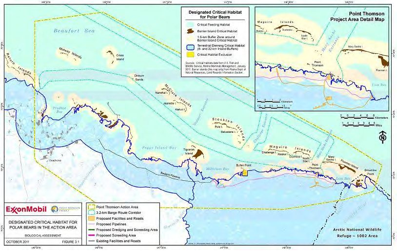
Table of Contents
1. INTRODUCTION .......................................................................................................... 1
2. DESCRIPTION OF THE PROPOSED ACTION ......................................................... 2
   Project Overview ............................................................................................................ 2
   Action Area ..................................................................................................................... 3
   Proposed Action .............................................................................................................. 3
      Central Pad .................................................................................................................. 3
      Drilling pads................................................................................................................ 6
      Other gravel pads ........................................................................................................ 6
      Pipelines ...................................................................................................................... 6
      Roads and ground transportation ................................................................................ 6
      Airstrip and air transport ............................................................................................. 7
      Marine facilities and transportation ............................................................................ 8
      Gravel mine ................................................................................................................. 8
      Construction camps and workforce estimate .............................................................. 9
      Communications ......................................................................................................... 9
      Electrical power facilities ........................................................................................... 9
      Operations and maintenance ....................................................................................... 9
      Waste management ................................................................................................... 10
      Spill prevention and response ................................................................................... 10
   Conservation Measures ................................................................................................. 10
      Listed eiders and yellow-billed loons ....................................................................... 10
      Polar bears ................................................................................................................. 12
3. EFFECT DETERMINATION FOR STELLER’S EIDER .......................................... 12
4. CONFERENCE REPORT ON YELLOW-BILLED LOON ....................................... 13
5. CONFERENCE REPORT ON PACIFIC WALRUS .................................................. 14
6. STATUS OF THE SPECIES AND CRITICAL HABITAT ....................................... 14
   Spectacled Eider............................................................................................................ 14
      Life history ................................................................................................................ 15
      Abundance and trends ............................................................................................... 21
      Threats to spectacled eiders ...................................................................................... 23
      Spectacled eider recovery criteria ............................................................................. 24
   Polar Bear...................................................................................................................... 24

                                                                  i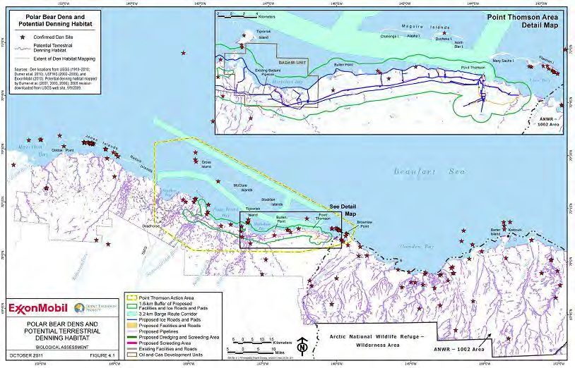
Distribution and status .............................................................................................. 24
     Movement patterns.................................................................................................... 25
     Feeding ...................................................................................................................... 26
     Reproduction ............................................................................................................. 27
     Life span and survivorship ........................................................................................ 30
     Abundance and trends – Alaska stocks ..................................................................... 30
     Threats to the polar bear ........................................................................................... 31
  Polar Bear Critical Habitat ............................................................................................ 31
7. ENVIRONMENTAL BASELINE............................................................................... 33
  Spectacled eiders ........................................................................................................... 33
     Status of spectacled eiders within the Action Area .................................................. 33
  Polar Bear...................................................................................................................... 36
     Status of polar bears in the Action Area ................................................................... 36
     Oil and gas development ........................................................................................... 36
     Deterrence Activities and Intentional Take Authorization ....................................... 37
     Lethal Take ............................................................................................................... 37
     Hunting ..................................................................................................................... 39
     Environmental contaminants .................................................................................... 39
     Climate change.......................................................................................................... 40
     Summary ................................................................................................................... 42
  Polar Bear Critical Habitat ............................................................................................ 42
     Status of polar bear critical habitat in the Action Area ............................................. 42
     Habitat loss and disturbance from oil and gas development..................................... 44
     Environmental contaminants .................................................................................... 44
     Climate change.......................................................................................................... 44
8. EFFECTS OF THE ACTION ON LISTED SPECIES AND CRITICAL HABITAT 45
  Spectacled Eiders .......................................................................................................... 46
     Collisions with structures .......................................................................................... 46
     Increased predator populations ................................................................................. 47
     Oil spills .................................................................................................................... 48
     Long-term habitat loss .............................................................................................. 48
  Polar Bears .................................................................................................................... 50
     Denning polar bears .................................................................................................. 50
     Disturbance to non-denning bears ............................................................................ 51

                                                                 ii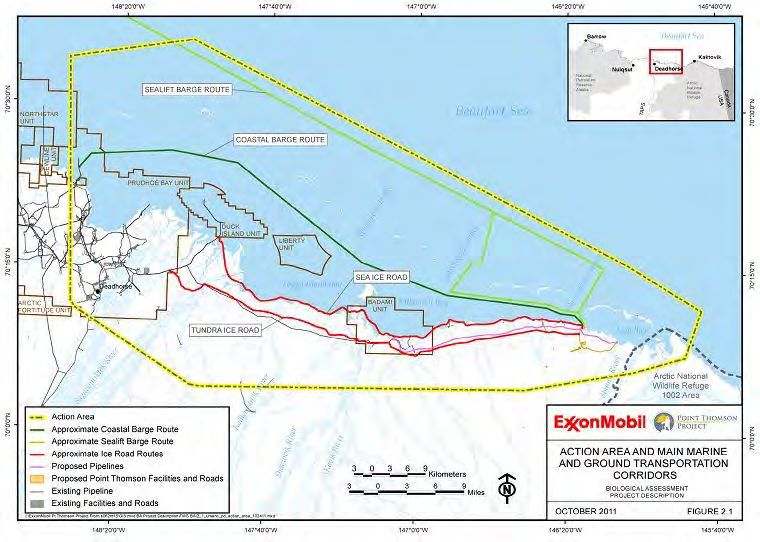
Disturbance from aircraft .......................................................................................... 51
       Increased polar bear–human interactions.................................................................. 51
       Habitat loss................................................................................................................ 53
       Oil spills .................................................................................................................... 53
   Polar Bear Critical Habitat ............................................................................................ 54
       Effects on sea ice habitat........................................................................................... 54
       Effects on terrestrial denning habitat ........................................................................ 54
       Effects on barrier island habitat ................................................................................ 55
   Interdependent and Interrelated Effects ........................................................................ 56
9. CUMULATIVE EFFECTS ......................................................................................... 56
10. CONCLUSION .......................................................................................................... 57
   Spectacled Eiders .......................................................................................................... 57
   Polar Bears .................................................................................................................... 58
   Polar Bear Critical Habitat ............................................................................................ 58
   Future Consultation ....................................................................................................... 59
11. INCIDENTAL TAKE STATEMENT ....................................................................... 59
   Spectacled Eiders .......................................................................................................... 60
12. REASONABLE AND PRUDENT MEASURES ...................................................... 61
   Polar Bears .................................................................................................................... 61
   Spectacled Eiders .......................................................................................................... 61
13. TERMS AND CONDITIONS ................................................................................... 61
14. CONSERVATION RECOMMENDATIONS ........................................................... 62
   Polar Bears .................................................................................................................... 62
   Spectacled Eiders .......................................................................................................... 63
15. REINITIATION NOTICE ......................................................................................... 63
13. LITERATURE CITED .............................................................................................. 63

                                                       List of Figures

Figure 1. Project facilities overview. Figure 2.2 of the BA (Johnson et al. 2011) ........... 4
Figure 2. Point Thomson Project Action Area. Figure 2.1 in the BA (Johnson et al.
2011). .................................................................................................................................. 5
Figure 3. (A) Male and female spectacled eiders in breeding plumage. (B) Distribution
of spectacled eiders. Molting areas (green) are used July–October. Wintering areas
(yellow) are used October –April. The full extent of molting and wintering .................. 16

                                                                   iii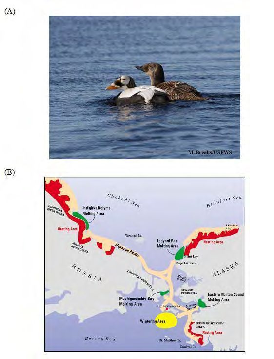
Figure 4. Density distribution of spectacled eiders observed on aerial transects sampling
57,336 km2 of wetland tundra on the North Slope of Alaska during early to mid-June,
2007–2010 (Larned et al. 2011). ....................................................................................... 17
Figure 5. Spectacled eider satellite telemetry locations for 12 female and 7 male
spectacled eiders in the eastern Chukchi Sea from 1 April – 15 June 2010 and 1 April –
15 June 2011. Additional locations from the northern coast of Russia are not shown.
Eiders were tagged on the North Slope during the 2009 and 2010 breeding seasons. Data
provided by Matt Sexson, USGS Alaska Science Center (USGS, unpublished). ............ 22
Figure 6. Ranges of polar bear stocks in Alaska (USFWS 2010a) .................................. 26
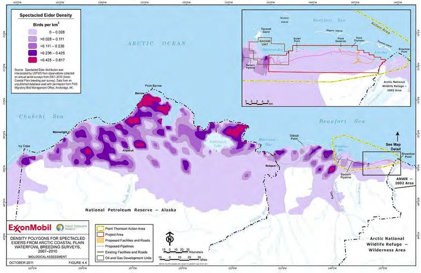
Figure 7. Estimated spectacled eider density on the Arctic Coastal Plain, Action Area,
and in near project infrastructure (map detail). Density polygons are based on data
collected during the 2007–2010 Arctic Coastal Plain aerial surveys (Larned et al. 2011).
Figure 4.4 in the BA (Johnson et al. 2011) ....................................................................... 35
Figure 8. Polar bear dens and potential terrestrial denning habitat in the Point Thomson
Action Area. Source: Point Thomson Project BA (Johnson et al. 2011). ........................ 38
Figure 9. Polar bear critical habitat in the Action Area. The Terrestrial Denning Unit
includes terrestrial habitat within 8 km (5 mi) inland from the Beaufort Sea coast east of
the Kavik River and 32 km (20 mi) inland west of the Kavik River. The Barrier Island
Unit includes barrier islands, spits, and a 1.6 km zone of adjacent aquatic and terrestrial
habitats. These areas are identified as both barrier island critical habitat and a
surrounding 1.6-km zone in the map above. The Sea Ice Unit is identified as critical
feeding habitat in the map above. Source: Point Thomson Project BA (Johnson et al.
2011). ................................................................................................................................ 43
List of Tables
Table 1. Important molting areas for female and male spectacled eiders from each
breeding population. ......................................................................................................... 20
iv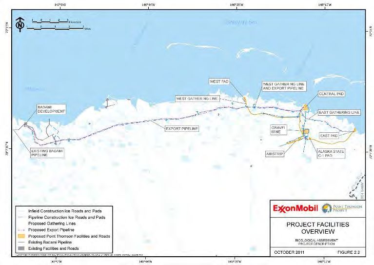
1. INTRODUCTION
This document transmits the U.S. Fish and Wildlife Service’s (Service) Biological
Opinion (BO) on a proposal by Exxon Mobil Corporation (ExxonMobil) to initiate
development of a hydrocarbon reservoir at Point Thomson on State of Alaska leases on
the Arctic Coastal Plain, approximately 80 km (50 miles) east of Prudhoe Bay. Because
the project will impact waters of the United States, ExxonMobil has requested a section
404 permit from the U.S. Army Corps of Engineers (USACE). The USACE submitted a
Biological Assessment (BA; Johnson et al. 2011) for the Point Thomson Project prepared
by ABR, Inc. Environmental Research and Services on behalf of ExxonMobil to the
Service on January 26, 2011. The applicant and designated non-federal representative is
ExxonMobil; the PTE Pipeline LLC, a wholly owned subsidiary of ExxonMobil Pipeline
Company, is a joint applicant (Johnson et al. 2011). PTE Pipeline LLC will own and
operate the project’s export pipeline.
This BO describes the effects of the Proposed Action on Alaska-breeding Steller’s eiders
(Polysticta stelleri), spectacled eiders (Somateria fischeri), polar bears (Ursus
maritimus), and polar bear critical habitat pursuant to section 7 of the Endangered
Species Act (ESA) of 1973, as amended (16 U.S.C. 1531 et seq.). Conference reports for
yellow-billed loon (Gavia adamsii) and Pacific walrus (Odobenus rosmarus divergens),
which are listed as candidate species under the ESA, are also included in the document.
We used information provided in the project BA; project-specific communications with
the USFWS Alaska Region Marine Mammal Management (USFWS MMM) office; other
Service documents; and published and unpublished literature to develop this BO.
Section 7(a)(2) of the ESA states that Federal agencies must ensure that their activities
are not likely to:
Jeopardize the continued existence of any listed species, or
Result in the destruction or adverse modification of designated critical habitat.
The Service has determined the Proposed Action may affect but is not likely to adversely
affect Steller’s eiders and may adversely affect spectacled eiders, polar bears, and polar
bear critical habitat. We have also determined that the Proposed Action is not likely to
jeopardize the continued existence of yellow-billed loons or Pacific walruses.
Following review of the status and environmental baseline of spectacled eiders, polar
bears, and polar bear critical habitat, and analysis of the potential effects of the Proposed
Action to these listed entities, the Service has concluded the Proposed Action is not likely
to jeopardize the continued existence of spectacled eiders or polar bears, and is not likely
to destroy or adversely modify polar bear critical habitat.
If you have comments or concerns regarding this BO, please contact Ted Swem,
Endangered Species Branch Chief, Fairbanks Fish and Wildlife Field Office at (907) 456-
0441.
Point Thomson Project Biological Opinion, USACE 2012 1
2. DESCRIPTION OF THE PROPOSED ACTION
Project Overview
ExxonMobil is proposing to initiate hydrocarbon production from the Thomson Sand
reservoir on the eastern Arctic Coastal Plain (ACP). Surface development (Figure 1)
would occur approximately 80 km (50 mi) east of Prudhoe Bay and approximately 3–10
km (2–6 mi) west of the Staines River. ExxonMobil proposes to produce gas from the
reservoir, recover liquid hydrocarbons, re-inject the residual gas back into the reservoir,
and delineate and test other hydrocarbon resources encountered during project
implementation.
The primary project components are:
Three gravel pads—Central, East, and West Pads
Central Processing Facility (CPF) located on Central Pad
Infrastructure required to drill and produce five development wells including two
existing wells at Central Pad
Marine offloading facilities (service pier and sealift bulkhead) and boat launch
Gravel airstrip for all-season transportation and emergency response
Gravel mine site
Gravel road network (18.4 km [11.4 mi])
Winter ice roads (239 km [149 mi]) in support of construction and operations
Export pipeline (35 km [22 mi]), a common carrier pipeline to transport
hydrocarbon liquids from the Central Pad at Point Thomson to the Badami
Development.
Infield gathering lines (16 km [10 mi])
The Point Thomson Project will place gravel fill on approximately 1.08 km² (267 acres)
of tundra. Footprint coverage and road lengths are summarized in Table 2.3 of the
project BA (Johnson et al. 2011). Project facilities will not be connected to other oilfields
or developed areas by all-season roads. Equipment, materials, supplies, and personnel
will be transported via seasonal ice roads, aircraft, and sea-going barges. Gravel
structures will be constructed primarily in the winter by using standard North Slope
equipment and methods. Some gravel placement will also occur during summer;
however, no placement of gravel directly on tundra during the summer is planned.
ExxonMobil has proposed to construct the Point Thomson Project over four winter
seasons (2012/2013–2015/2016). Facility commissioning/startup and construction
demobilization is expected to occur in late 2015–early 2016. Estimated timeframes for
major elements of the Project are shown in Table 2.1. Two wells at the Central Pad were
drilled, cased, flow-tested, and suspended in 2009 and 2010; additional drilling is
expected to begin in 2015. The operational life of the project is expected to be ~30 years.
Detailed facility closure and abandonment procedures have not been developed and are
not part of the Proposed Action.
Point Thomson Project Biological Opinion, USACE 2012 2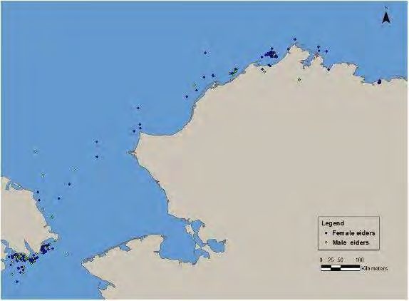
Action Area
The Action Area is the area in which direct and indirect effects of the action to
listed species and designated critical habitat may occur. The area directly affected
by the proposed project includes gravel pads and roads (including the airstrip), the
export pipeline and infield gathering lines, ice roads and pads, the material source
site, barge routes and facilities, and areas potentially affected by terrestrial or
marine spills. The area indirectly affected by the proposed project is delineated
by a zone of influence1 surrounding new infrastructure within which listed species
may be affected by disturbance resulting from construction activities.
The Point Thomson Project BA (Johnson et al. 2011) delineates the Action Area
(Figure 2) as an area generally between the Staines River on the east and Prudhoe
Bay on the west, and from 10 km (6 mi) seaward side of the barrier islands to a
point inland of the proposed airstrip. In addition to proposed new development,
the Action Area includes winter ice road routes, coastal and sealift barge routes in
the Beaufort Sea, docking facilities at West Dock in Prudhoe Bay, and areas
potentially affected directly and indirectly by air and sea transportation and
marine spills, and at least a 1.6-km (1 mi) zone surrounding transportation routes
and facilities (Figure 2).
Proposed Action
Project components and associated construction, operations, and maintenance activities
are summarized below. Project infrastructure and implementation are described further
in the Point Thomson BA (Johnson et al. 2011).
Central Pad
The approximately 22.7-ha (56-acre) Central Pad includes the existing 5.36-ha (13-acre)
PTU-3 exploration pad site and two existing development wells. The Central Pad is
located to access the core of the Thomson Sand reservoir. The following facilities will
also be located on the Central Pad:
CPF (main process and utility modules) and associated support and infrastructure
facilities
Class I disposal well
High- and low-pressure flares and auxiliary equipment
Diesel and methanol storage tanks
Cold storage area with associated pipe racks, cable racks, warehouse, and storage
equipment and Staging areas
Grind and inject module
Camp and camp utility modules
Communications facility
1
This zone of influence is assumed to be 200 m (656 ft) for spectacled eiders and 1.6 km (1 mi) for polar
bears.
Point Thomson Project Biological Opinion, USACE 2012 3Figure 1. Project facilities overview. Figure 2.2 of the BA (Johnson et al. 2011) Point Thomson Project Biological Opinion, USACE 2012 4
Figure 2. Point Thomson Project Action Area. Figure 2.1 in the BA (Johnson et al. 2011).

Point Thomson Project Biological Opinion, USACE 2012                                       5
At the CPF, the 3-phase stream (gas, water, and hydrocarbon liquids) produced from the
wells will be separated with a design capacity of up to 5.7 million standard cubic meters
per day of natural gas for recovery of approximately 10,000 barrels per day of
hydrocarbon liquids (condensate). Hydrocarbon liquids will be recovered and stabilized
for transport through the Export Pipeline. Produced water will be injected into the Class
1 disposal well; produced gas will be conserved and used as a fuel source for the facility
or re-injected into the reservoir through the gas injection well. The flare system will be
used to burn natural gas when pipelines and facilities are depressurized for maintenance,
during a process upset, or in an emergency situation. Flares will be combined into a
single flare stack just west of the main Central Pad; flare tips will not exceed 46 m (150
ft.) above ground surface.
Drilling pads
The East and West drilling pads will be located 6.3 and 6.9 km (3.9 and 4.3 mi) from the
Central Pad (Figure 1). The East Pad will be approximately 6.31 ha (15.6 acres) in size
and has been located to include the existing North Staines River State No.1 gravel pad
(1.94 ha [4.8 acres]). The West Pad will be a new gravel pad approximately 7.66 ha
(18.9 acres) in size. Drilling will also be conducted at the Central Pad.
Other gravel pads
The project also includes the following additional gravel pads:
Existing Alaska State C-1 Pad – 1.65 ha (4.1 acres)
Badami Pads – two small pads associated with the Export Pipeline; 0.17 ha (0.4
acres)
Gravel Storage Pad – 5.21 ha (12.9 acres)
Airstrip/Helipad/Navaid Pad – 19 ha (47 acres; discussed further below)
Pipelines
The infield gathering lines and the Export Pipeline will be supported on vertical support
members (VSMs) sized to maintain a minimum 2.1 m (7 ft) height between the bottom of
the pipe and the tundra surface. Construction will be accomplished during the winter
from tundra ice roads and small ice pads located along the ice road for materials storage
and staging. The East Pad and West Pad gathering lines are each ~7.7 km (4.8 mi) in
length and the Export Pipeline is ~35 km (22 mi). The Export Pipeline and West Pad
gathering line will be placed on common VSMs for about 6.2 km (4 mi).
Roads and ground transportation
Ground transportation will use a system of onshore (tundra) and offshore (sea) ice roads
during winter construction and a network of gravel infield roads during drilling and
operations. Off road tundra travel using approved tundra travel vehicles may also occur
during construction and operations.
Infield access roads – Approximately 18.4 km (11.4 mi) of in-field gravel roads will be
constructed to connect gravel pads, the airstrip, the gravel mine, and freshwater supply
source(s) to the Central Pad (Figure 2.1). Bridges or culverts will be installed at 9 stream
Point Thomson Project Biological Opinion, USACE 2012 6crossings during winter construction with the exception of two culverts designed for fish passage, which will be installed during low flow conditions in late summer. Ice roads and pads – Ice roads and pads will be constructed during winter as needed to support construction and operations and to connect Point Thomson to the existing gravel road system at Endicott (Figure 2.2). Approximately 72 km (45 mi) of infield and pipeline ice roads and 46.8 ha (116 acres) of ice pads will be used to support construction in the Point Thomson Project Area. The ice road between Point Thomson and Endicott could be constructed on the sea ice adjacent to the Beaufort Sea coast or the tundra (each option 75.6 km [47 mi] long). Ice road size and route will vary depending on seasonal ice conditions, polar bear den locations, and the expected size and weight of the loads, and may be up to 23 m (75 ft) wide for large equipment access and safety. Freshwater for ice roads and pads will be supplied from approved water sources. Ice road activity could begin as early as November each winter, depending on weather conditions and permitting status. ExxonMobil, working with the USFWS MMM, will survey ice road routes and the proposed pipeline routes using Forward-looking Infrared (FLIR) imaging technology for the purpose of detecting polar bear dens prior to ice road construction. Known locations of radio- or satellite-collared bears, U.S. Geological Survey (USGS) denning habitat maps, and ground-truthing would also be used as necessary to detect dens. Conservation measures to avoid adverse effects to dens would be implemented based on recommendations by USFWS MMM and may include rerouting ice roads to maintain a distance of 1.6 km (1 mile) from known dens. Airstrip and air transport A year-round gravel airstrip will be constructed south of the Central Pad, approximately 5 km (3 mi) from the coast (Figure 1). The airstrip’s dimensions will be approximately 1,707 m (5,600 ft) long by 61 m (200 ft) wide, with an access road, apron, helipad, and ancillary navigation aid pads (total area of 19 ha [47 ac], Table 2.3). After the gravel runway has been installed, navigational aids, approach lighting, and control buildings will be installed. The area for approach lights will require an ice road to be constructed prior to pile installation. This ice road will also be used for installation of the power cable and lights. Power cables will be trenched beside the gravel access road to the airport, and then run through a conduit strung along sleepers to service the runway lights. A temporary helipad will be located at the Central Pad and used until the helipad at the gravel airstrip is operational. Aircraft will be used year-round to transport equipment, materials, supplies, and personnel, and for emergency support. Initially, air traffic will be restricted to helicopters. After the gravel airstrip is constructed and commissioned, fixed-wing aircraft will be the normal method used to transport personnel and emergency medical evacuation. Both helicopter and fixed-wing aircraft will be required to support on-site activities. One to two C-130 flights may be used to transport or materials and equipment Point Thomson Project Biological Opinion, USACE 2012 7
early in the construction period and when materials and equipment cannot otherwise be
moved in a timely manner. Fixed-wing cargo and passenger aircraft (e.g., Beechcraft
1900, Casas, Dash 8/SAAB 340, Twin Otter turbo-prop or DC-6) and helicopters will
transport normal operational materials, equipment, supplies, and personnel between
Deadhorse and Point Thomson. Up to 2–3 flights per day will occur through all phases
of construction. Aircraft flying between Deadhorse and the Point Thomson airstrip will
maintain a normal operational altitude of 457 m (1,500 ft) and follow a route inland of
the coast unless deviations are required for safety or operation requirements.

Marine facilities and transportation
Three marine facilities, the boat launch, sealift bulkhead, and service pier, are associated
with the Central Pad. The boat launch will be located in a protected lagoon on the east
side of the Central Pad and suitable for launching the smaller emergency response vessels
that will be stationed at Point Thomson. The onshore (above mean high water) sealift
bulkhead and four offshore mooring dolphins will be constructed adjacent to and offshore
of the Central Pad. The service pier for offloading coastal barges will be constructed
adjacent to the sealift bulkhead; the docking facility will consist of a 36-m × 9-m (120-ft
× 30-ft) pier, extending ~21 m (70 ft) offshore of the Central Pad shoreline, and four
mooring dolphins. Screeding or shallow dredging will be used as needed to achieve and
maintain the required seabed depth profile for marine facilities, affecting a total area of
up to ~14,307 m² (5.5 acres), with disposal of seabed material above mean high water
along the nearby shoreline.

Equipment and materials will be transported to Point Thomson via coastal barges and
oceangoing (sealift) barges when ice roads are not available and for heavy loads that
cannot be transported by aircraft. Coastal barges will be used to transport material,
equipment, fuel, and other supplies to Point Thomson and to remove wastes and excess
equipment during the open water season. Two to four coastal barges could operate during
the barging season (approximately July 15 – August 25). ExxonMobil estimates 80
roundtrips per season would be required during construction and construction
demobilization (2013–2016), 20–100 during drilling (2015–2017), and 15 per year during
operations (2017 and beyond). Sealift (oceangoing) barges supported by tugboats will
transport large, prefabricated facility (production and camp) modules and heavy
equipment from locations outside of Alaska using standard marine shipping routes. In
the Beaufort Sea these routes generally occur offshore of the barrier islands and pass
through either the Challenge or Mary Sachs Entrance to access Point Thomson (Figure
2). Modules will be offloaded via a barge bridge system consisting of three barges
temporarily grounded in place during offloading operations. Sealift barges will be
docked at Point Thomson approximately 2–4 weeks during July or August. A single
delivery of modules is planned by sealift barge flotilla in the 2015 or 2016 summer
season.

Gravel mine
The primary gravel source will be a new 20 ha (49.6-acre) mine site located ~3 km (2 mi)
south of the Central Pad and just north and east of the airstrip (Figure 1). ExxonMobil
estimates 1,720,248 m³ (2,250,000 yd³) of gravel and 802,783 m³ (1,050,000 yd³) of

Point Thomson Project Biological Opinion, USACE 2012                                       8
organic and inorganic overburden will be removed from the mine site over a two-year
period.

The rehabilitation plan includes placing back overburden into the excavated area and
creating stabilized sidewalls and a mosaic of wet and moist habitat conditions. The
excavated area is expected to fill with water over 5–10 years, forming shallow water
habitat for birds and deep-water habitat for fish, and may serve as a potential backup
water source for the project.

Construction camps and workforce estimate
Construction camps in Deadhorse and at Point Thomson will be used to house workers in
the field. There will be a small camp addition to ExxonMobil’s existing facility near
Deadhorse and the project will also use existing camps in Deadhorse to the extent
practicable. The Point Thomson camps will be placed on either single-season ice pads or
gravel pads. The number of beds, utilities specifics, and timing of mobilization/
demobilization is expected to peak at 500–600 beds during the construction period. The
construction workforce is expected to peak at approximately 500 personnel. Drilling-
related employment is estimated to be 150–180 personnel and the operations workforce is
estimated to be 80 people.

Communications
Communications services will be supported by tower structures at multiple project
locations. The CPF main communication tower will be located on the Central Pad and
will be up to 61 m (200 ft) in height. Four lattice towers will be installed at the airstrip
for communications, lighting, navigational aids, and speaker mounting and will be 11–17
m (35–55 ft) in height. Permanent towers will be free-standing with no guy wires.

A temporary, 23-m (75-ft) lattice telecommunications tower is planned to be installed in
December 2012 at the Central Pad in support of early construction activities and will be
removed March–April 2013 after the permanent telecommunications tower is
commissioned for service. The temporary tower will be supported by two sets of three
guy wires, each equipped with striped, high visibility guards.

Electrical power facilities
Temporary diesel fuel-powered electrical generators will provide power during
construction. Once natural gas is available, four gas-fired turbine generators will be used
to meet peak power requirements. Power cables from the CPF to East and West Pads
will be attached to gathering line VSMs. Power cables from the CPF to the airstrip and
the Alaska State C-1 water supply reservoir will be buried in a trench along the roadbed.
No overhead power lines are planned.

Operations and maintenance
Operations and maintenance responsibilities would include road and pad maintenance
using typical North Slope construction equipment; pipeline monitoring and maintenance;
snow removal; installation of snow fences; culvert inspections and debris removal. Fuel
and hazardous substances will be stored and handled in accordance with applicable

Point Thomson Project Biological Opinion, USACE 2012                                       9
regulations and permit stipulations. Pipelines may be accessed by using Rolligons (or
similar tundra travel equipment) when tundra travel is allowed, from winter ice roads, or
by helicopter. Integrity monitoring of pipelines will involve inline inspection tools and
visual inspection of the pipelines, including weekly aerial surveillance of the pipelines
and surrounding area except when precluded by safety or weather conditions.
Waste management
ExxonMobil will develop a comprehensive Waste Management Plan prior to project
implementation. Wastes will be handled in accordance with the Alaska Waste Disposal
and Reuse Guide (Red Book), in full compliance with federal, state, and North Slope
Borough regulatory requirements.
Most waste fluids from drilling, production, operations and maintenance, and domestic
sources will be injected into a Class I disposal well; when the disposal well is unavailable
(e.g., during construction) treated wastewater from construction camps will be discharged
in compliance with Alaska Pollutant Discharge Elimination System (APDES) and/or
National Pollution Discharge Elimination System (NPDES) permits. Some wastes and
recyclable materials will be transported to other facilities in Alaska or the Lower-48
states for treatment, disposal, or recycling. All hazardous waste must be sent to
authorized off-site disposal facilities. Food wastes and garbage that could attract wildlife
to Project facilities will be stored in enclosed, bear-proof containers and incinerated on a
daily basis. A wastewater treatment plant will be located on the Central Pad. Sewage
sludge will be incinerated on-site or stored in enclosed tanks until being shipped to the
North Slope Borough treatment plant in Deadhorse.
Spill prevention and response
Numerous prevention, design, detection, reporting, response, and training measures are
described in the Project Plan of Operations Alaska Department of Environmental
Conservation approved Oil Discharge Prevention and Contingency Plan (ODPCP), and
Environmental Protection Agency required Spill Prevention, Control and
Countermeasure (SPCC) Plans and Facility Response Plans for project activities. These
are summarized in sections 2.8.1 and 2.8.2 of the project BA (Johnson et al. 2011). The
project specific oil spill prevention and preparedness plan is described in more detail in
Appendix C of the project BA (Johnson et al. 2011).
Conservation Measures
Measures identified in the project BA (Johnson et al. 2011) to minimize potential adverse
impacts of the Point Thomson Project on federally listed and candidate species are listed
below.
Listed eiders and yellow-billed loons
Implementing operational controls to minimize nesting opportunities for
predatory birds and denning opportunities for predatory mammals.
o Blocking off nest sites on structures with fabric/netting or other bird nest
deterrent.
Point Thomson Project Biological Opinion, USACE 2012 10o Using devices to deter the birds when they land in places likely to be
nesting sites.
o Removing nest material before birds lay eggs.
Deterring foxes from denning by elimination of open containers, culverts, pipes,
and other potential shelters at ground level.
Minimizing attraction of predatory birds and mammals to food and wastes at
facilities.
Designing facilities to minimize potential for bird strikes.
o Design of facility lighting (e.g., light hoods to reduce outward radiating
light) minimizes the potential for disorienting migrating birds.
o Buildings and stack heights will be as low as practicable.
o Flares will be free standing (no guy wires).
o The primary Central Pad communications tower will be free standing (no
guy wires; the tower will be lighted according to Federal Aviation Agency
requirements).
o Other communications towers (e.g., at the airstrip or other pads) will avoid
the use of guy wires and will be attached to camps or other larger
structures when possible.
o Power lines and fiber-optic cables will either be buried or placed on the
pipeline VSMs.
Reducing disturbance to birds by completing most construction activities during
winter. Should site preparation and/or construction activities occur during the
summer on the tundra prior to July 31, the areas in the vicinity of these field
activities will be searched for nesting birds by qualified biologists prior to the
start of work. If an active nest of a migratory bird is found (even after July 31),
the appropriate USFWS Field Office will be contacted for instructions on how to
avoid or mitigate the potential loss of the active nest.
Reducing disturbance to birds by controlling vehicle speed and aircraft altitude
and flight routes. Vehicle speeds will be limited to 35 mph and aircraft will fly at
457 m (1,500 ft) above ground level and follow a route inland of the coast to
avoid the most likely breeding areas except when required for operational or
safety reasons.
Minimizing overall vegetation and habitat loss by use of existing gravel pads,
minimal footprint size, and roadless connection to Prudhoe Bay and Alaska
Highway system.
Rehabilitating the gravel mine to enhance habitat for waterfowl.
Implementing spill prevention and response programs.
Point Thomson Project Biological Opinion, USACE 2012 11Polar bears
Conservation measures for polar bears will be implemented through the Point Thomson
Project’s Polar Bear and Wildlife Interaction Plan (Appendix A of the Project BA
[Johnson et al. 2011]) and through compliance with any Letters of Authorization (LOAs)
issued by USFWS for incidental take by harassment of polar bears, under the existing
Beaufort Sea Incidental Take Regulations (Beaufort Sea ITRs; 76 FR 47010).
Conservation measures identified in the project BA (Johnson et al. 2011) include:
Conducting FLIR surveys annually for potential maternal polar bear dens along
ice road routes.
Implementing procedures and communications protocols for wildlife (polar bear)
encounters.
Rerouting an ice road if an active polar bear den is discovered within 1.6 km (1
mi) of the ice road route or taking other actions approved by the USFWS.
Closing an ice road if a maternal polar bear den is observed during the den
emergence period (early March to mid-April), in consultation with the USFWS.
Conducting ice road closure drills to practice the ice road closure protocol.
Watching for polar bears by using bear monitors [and deterring polar bears from
Project activities, as necessary, using USFWS-approved deterrent methods].
Employing operational controls (e.g., road and air traffic restrictions).
Ensuring Project workers attend training programs, such as Arctic Pass, which
cover polar bear and wildlife awareness.
Communicating with the workforce on polar bear issues through Environmental
Bulletins, posters, safety meeting discussions, etc.
Developing project design and operational features to avoid or discourage wildlife
encounters and to protect wildlife and human safety (e.g., building walkways,
doors, lighting, snow management, and traffic control).
Implementing spill prevention and response programs.
3. EFFECT DETERMINATION FOR STELLER’S EIDER
In Alaska, Steller’s eiders breed almost exclusively on the ACP, migrating to the
breeding grounds in late spring and remaining in the region as late as mid-October.
However, nesting is concentrated in tundra wetlands near Barrow, AK and Steller’s
Point Thomson Project Biological Opinion, USACE 2012 12eiders occur at very low densities elsewhere on the ACP (Larned et al. 2010). USFWS
aerial surveys for breeding eiders conducted annually on the ACP from 1992–2010
reported only 5 observations of Steller’s eiders east of the Colville River, with the most
recent observation in 1998 (USFWS Alaska Region Migratory Bird Management,
unpublished data). Because available data indicate Steller’s eiders are unlikely to nest
near or migrate through the project area, we conclude that adverse effects to the species
are extremely unlikely to occur, and will therefore be discountable, and the Proposed
Action is not likely to adversely affect Steller’s eiders.
4. CONFERENCE REPORT ON YELLOW-BILLED LOON
The yellow-billed loon was listed as a candidate species under the ESA on March 25,
2009 (USFWS 2009) due to its small population size range-wide and concerns about
levels of subsistence harvest and other potential impacts to the species. Within Alaska,
there are two breeding areas – the North Slope region north of the Brooks Range and the
region surrounding Kotzebue Sound in northwest Alaska, primarily the northern Seward
Peninsula (Earnst 2004, North 1993). Nest sites are usually located on islands,
hummocks, peninsulas, or along low shorelines, within 1 m of water. Young leave the
nest soon after hatching and the brood may move from the natal lake to a brood-rearing
lake within days of hatch. Both males and females participate in feeding and caring for
young (North 1994). Successfully breeding adults feed their young almost entirely from
the brood-rearing lake (North 1994). Non-breeding individuals remain in marine waters
throughout the year, either in wintering areas or offshore from breeding grounds.
Yellow-billed loon density is very low in the Action Area, with higher concentrations
occurring to the west, between the Meade and Colville rivers (Earnst 2004, Larned et al.
2011). Density polygons constructed from data collected during the 2007–2010
waterfowl breeding population surveys of the ACP place yellow-billed loon density in the
Action Area in the range of 0–0.030 birds/km2 (Larned et al. 2011; also see Figure 3.10
of the Point Thomson Project BA [Johnson et al. 2011]). Although yellow-billed loons
have been observed in the project area and on the Canning River Delta to the east (see
review in Johnson et al. 2011), there is no evidence of nesting in these areas. Yellow-
billed loons occur in low numbers in nearshore marine waters (see Figure 3.8 of the
project BA [Johnson et al. 2011]).
Adverse effects to yellow-billed loons could occur through direct and indirect long-term
habitat loss, collisions with structures, increased predator populations, loss of marine
foraging habitat associated with construction of marine facilities at the Central Pad, and
direct effects from oil spills. Because loon densities are relatively low in the Action
Area, we expect the number of birds that could be potentially affected by these threats to
be very low. Some yellow-billed loons that nest in Canada may migrate through the
Action Area, and thus are possibly exposed to risk of collision with structures, but to date
we have no information to suggest that yellow-billed loons are susceptible to colliding
with large industrial structures. Thus, we have no reason to believe that population-level
effects of collisions from the Proposed Action are a possibility. We expect potential
Point Thomson Project Biological Opinion, USACE 2012 13adverse effects to yellow-billed loons would be reduced through proposed conservation
measures, such as designing facility lighting to reduce collision risk, preventing raven
nests on project infrastructure, controlling the availability of anthropogenic food sources,
and oil spill prevention and containment measures.
A conference on a candidate species results in a determination of whether the Proposed
Action is likely to jeopardize the continued existence of the species. Because yellow-
billed loons occupy both terrestrial and marine habitats in the Action Area at very low
densities and conservation measures are in place to reduce risks to yellow-billed loons
that do occur in the area, we conclude that effects from the Proposed Action would be
insignificant and the Proposed Action is not likely to jeopardize the continued existence
of yellow-billed loons.
5. CONFERENCE REPORT ON PACIFIC WALRUS
The Pacific walrus was listed as a candidate species under the ESA with the publication
of the 12-month petition finding on February 10, 2011 (USFWS 2011a). Pacific walruses
occur in the Beaufort Sea in extremely low numbers because the continental shelf is
relatively narrow along the Beaufort Sea and its deeper, less productive waters provide
limited food resources. In years of low ice concentrations in the Chukchi Sea, some
animals range east of Point Barrow into the Beaufort Sea (Fay 1982). However, from
1994 to 2004, oil industry monitoring programs recorded only 10 animals in the Beaufort
Sea (USFWS 2011a). The USGS also reported that only a few tagged walruses entered
the extreme western portion of the Beaufort Sea near Barrow during studies of Pacific
walrus movement in 2007–2011 (USGS 2012).
A conference on a candidate species results in a determination of whether the Proposed
Action is likely to jeopardize the continued existence of the species. Because walruses
are rarely observed in the Beaufort Sea, we conclude that effects from the Proposed
Action would be discountable and the Proposed Action is not likely to jeopardize the
continued existence of the Pacific walrus.
6. STATUS OF THE SPECIES AND CRITICAL HABITAT
This section presents biological and ecological information relevant to formation of the
BO. Appropriate information on the species’ life history, habitat and distribution, and
other factors necessary for their survival is included for analysis in later sections.
Spectacled Eider
Spectacled eiders (Error! Reference source not found.A) were listed as threatened
throughout their range on May 10, 1993 (USFWS 1993) based on indications of steep
declines in the two Alaska-breeding populations. There are three primary spectacled
eider populations, based on breeding distribution; these are the North Slope, Yukon–
Kuskokwim Delta (YKD), and northern Russia populations. The YKD population
Point Thomson Project Biological Opinion, USACE 2012 14declined 96% between the early 1970s and 1992 (Stehn et al. 1993). Data from the Prudhoe Bay oil fields (Warnock and Troy 1992) and information from Native elders at Wainwright, AK (R. Suydam, pers. comm. in USFWS 1996) suggested concurrent localized declines on the North Slope, although data for the entire North Slope breeding population were not available. Spectacled eiders molt in several discrete areas (Error! Reference source not found.B) during late summer and fall, with birds from the different populations and genders apparently favoring different molting areas (Petersen et al. 1999). All three spectacled eider populations overwinter in openings in pack ice of the central Bering Sea, south and southwest of St. Lawrence Island (Petersen et al. 1999; Figure 3.9B), where they remain until March–April (Lovvorn et al. 2003). Life history Breeding – In Alaska, spectacled eiders breed primarily on the North Slope (ACP) and the YKD. On the ACP, spectacled eiders breed north of a line connecting the mouth of the Utukok River to a point on the Shaviovik River about 24 km (15 miles) inland from its mouth. Breeding density varies across the ACP (Figure 4). Although spectacled eiders historically occurred throughout the coastal zone of the YKD, they currently breed primarily in the central coast zone within about 15 km (~9 miles) of the coast from Kigigak Island north to Kokechik Bay (USFWS 1996). However, a number of sightings on the YKD have also occurred both north and south of this area during the breeding season (R. Platte, USFWS, pers. comm. 1997). Spectacled eiders arrive on the ACP breeding grounds in late May to early June. Numbers of breeding pairs peak in mid-June and decline 4–5 days later when males begin to depart from the breeding grounds (Smith et al. 1994, Anderson and Cooper 1994, Anderson et al. 1995, Bart and Earnst 2005). Mean clutch size reported from studies on the Colville River Delta was 4.3 (Bart and Earnst 2005). Mean spectacled eider clutch size near Barrow was 4.1 ± 0.3 SE in 2009–2010 and 4.7 ± 0.3 in 2011 (Safine 2011, Safine in prep). Hatching occurs in mid-July (Bart and Earnst 2005, Safine 2011, Safine in prep). Nest initiation on Kigigak Island on the YKD occurs from mid-May to mid-June (Lake 2007). Incubation lasts approximately 24 days (Dau 1974). Mean spectacled eider clutch size is higher on the YKD compared to the ACP. Mean annual clutch size ranged from 3.8–5.4 in coastal areas of the YKD (1985–2011; Fischer at al. 2011), and 4.0–5.5 on Kigigak Island (1992–2011; Gabrielson and Graff 2011), with clutches of up to eight eggs reported (Lake 2007). Point Thomson Project Biological Opinion, USACE 2012 15
Figure 3. (A) Male and female spectacled eiders in breeding plumage. (B)
 Distribution of spectacled eiders. Molting areas (green) are used July–October.
 Wintering areas (yellow) are used October –April. The full extent of molting and
 wintering areas is not yet known and may extend beyond the boundaries shown.

Point Thomson Project Biological Opinion, USACE 2012                                16
Figure 4. Density distribution of spectacled eiders observed on aerial transects sampling
57,336 km2 of wetland tundra on the North Slope of Alaska during early to mid-June,
2007–2010 (Larned et al. 2011).

On the breeding grounds, spectacled eiders feed on mollusks, insect larvae (craneflies,
caddisflies, and midges), small freshwater crustaceans, and plants and seeds (Kondratev
and Zadorina 1992) in shallow freshwater or brackish ponds, or on flooded tundra.
Ducklings fledge approximately 50 days after hatch, and then females with broods move
directly from freshwater to marine habitat to stage prior to fall migration.

Nest success is highly variable and thought to be influenced by predators, including gulls
(Larus spp.), jaegers (Stercorarius spp.), and red (Vulpes vulpes) and arctic (Alopex
lagopus) foxes. In arctic Russia, apparent nest success was calculated as
all nests monitored in a coastal region of the YKD during the early to mid-1990s
contained inviable eggs and ~10% of eggs in successful nests did not hatch due to either
embryonic mortality or infertility (Grand and Flint 1997). This relatively high
occurrence of inviable eggs near the coast of the YKD may have been related to exposure
to contaminants (Grand and Flint 1997). It is unknown whether hatchability of eggs in
this region has improved with decreased use of lead shot in the region and natural
attenuation of existing lead pellets (Flint and Schamber 2010) in coastal YKD wetlands.

Recruitment rate (the percentage of young eiders that hatch, fledge, and survive to
sexual-maturity) of spectacled eiders is poorly known (USFWS 1999) because there is
limited data on juvenile survival. In a coastal region of the YKD, duckling survival to 30
days averaged 34%, with 74% of this mortality occurring in the first 10 days, while
survival of adult females during the first 30 days post hatch was 93% (Flint and Grand
1997).

Fall migration and molting – As with many other sea ducks, spectacled eiders spend the
8–10 month non-breeding season at sea, but until recently much about the species’ life in
the marine environment was unknown. Satellite telemetry and aerial surveys led to the
discovery of spectacled eider migrating, molting, and wintering areas. These studies are
summarized in Petersen et al. (1995), Larned et al. (1995), and Petersen at al. (1999).
Results of recent satellite telemetry research (2008–2011) are consistent with earlier
studies (Matt Sexson, USGS, pers. comm.). Phenology of spring migration and breeding,
including arrival, nest initiation, hatch, and fledging, is 3–4 weeks earlier in western
Alaska (YKD) than northern Alaska (ACP); however, phenology of fall migration is
similar between areas. Individuals depart breeding areas July–September, depending on
their breeding status and molt in September–October (Matt Sexson, USGS, pers. comm.).

Males generally depart breeding areas on the North Slope (ACP) when females begin
incubation in late June (Anderson and Cooper 1994, Bart and Earnst 2005). Use of the
Beaufort Sea by departing males is variable. Some appear to move directly to the
Chukchi Sea over land, while the majority moved rapidly (average travel of 1.75 days),
over near shore waters from breeding grounds to the Chukchi Sea (TERA 2002). Of 14
males with satellite transmitters, only four spent an extended period of time (11–30 days),
in the Beaufort Sea (TERA 2002). Preferred areas for males appeared to be near large
river deltas such as the Colville River where open water is more prevalent in early
summer when much of the Beaufort Sea is still frozen. Most adult males marked in
northern and western Alaska in a recent satellite telemetry study migrated to northern
Russia to molt (USGS, unpublished data). Results from this study also suggest that male
eiders are likely to follow coast lines but also migrate straight across the northern Bering
and Chukchi seas en route to northern Russia (Matt Sexson, USGS, pers. comm.).

Females generally depart the breeding grounds later, when much more of the Beaufort
Sea is ice-free, allowing for more extensive use of the area. Females spent an average of
two weeks in the Beaufort Sea (range 6-30 days) with the western Beaufort Sea the most
heavily used (TERA 2002). Females also appeared to migrate through the Beaufort Sea
an average of 10 km further offshore than the males (Petersen et al. 1999). The greater

Point Thomson Project Biological Opinion, USACE 2012                                      18
You can also read