Urbanising Suburbia Summary Report on Research Project - Hildebrand Frey - Sustainable urban form
←
→
Page content transcription
If your browser does not render page correctly, please read the page content below
Hildebrand
  Frey


Urbanising
  Suburbia

Summary
  Report
  on
  Research
  Project
Urbanising
Suburbia
Summary
Report
on
Research
Project
Preface
The
project
Urbanising
Suburbia,
the
responsibility
of
the
University
of
Strathclyde’s
Urban
Design
Studies
Unit
(UDSU)
at
the
Department
of
Architecture,
was
part
of
the
investigation
of
the
CityForm
(Sustainable
Urban
Form)
Consortium
funded
by
the
Engineering
and
Physical
Science
Research
Council
(EPSRC)
under
its
Sustainable
Urban
Environments
Programme
(Grant
number
GR/520529/01).
The
Consortium
comprised
a
multi-‐disciplinary
team
based
at
the
Universities
of
De
Montfort,
Heriot-‐Watt,
Oxford
Brookes,
Sheffield
and
Strathclyde.
The
key
task
of
the
core
research
was
to
investigate
to
what
extent
and
in
what
way
urban
forms
impact
social,
environmental,
ecological
and
transport
sustainability.
Information
on
the
consortium’s
work
is
available
on
the
CityForm
page,
www.cityform.org.uk.
Urbanising
Suburbia
was
one
of
the
satellite
projects.
It
examined
ways
in
which
(sub)urban
areas
–
housing
developments
often
but
not
always
at
the
city
fringes
considered
to
be
unsustainable
due
to
their
low
population
and
dwelling
densities
and
their
lack
of
local
amenities
–
can
be
transformed
into
become
more
sustainable
settlements.
The
research
team
members
and
their
responsibilities
were
as
follows:
• Hildebrand
Frey,
retired
Senior
Lecturer
and
Director
of
UDSU
at
the
Department
of
Architecture,
University
of
Strathclyde;
CityForm
Co-‐Investigator
He
held
overall
responsibility
for
the
project,
but
specifically
for
the
development
of
a
Tool
with
the
help
of
which
levels
of
sustainability
of
urban
areas
can
be
assessed
on
the
basis
of
threshold,
average
and
target
values
of
sustainable
urban
form.
He
was
also
responsible
for
the
application
of
the
Tool
in
a
number
of
theoretical
and
concrete
urban
regeneration
and
development
projects
to
measure
their
performance
values
and,
based
on
this,
formulate
regeneration
programmes.
Samer
Bagaeen,
Research
Associate
April
2004
to
October
2006
He
carried
out
the
review
of
all
relevant
literature
and
related
research
projects;
area
surveys,
including
land
and
building
uses,
built
form,
transport
infrastructure;
processing
and
mapping
of
primary
data
(survey
data
of
case
study
areas)
and
secondary
data
(the
Valuation
Roll,
Census
Statistics
and
information
provided
by
the
Glasgow
City
Council)
using
MapInfo
and
ArcGIS.
• Charalampos
Giachis,
Research
Associate
November
to
December
2006
He
generated
a
base
map
and
a
three-‐dimensional
model
of
the
existing
conditions
of
Glasgow’s
Greater
Govan
area,
using
a
number
of
software
packages.
• Pedro
Faria,
Research
Associate
June
to
September
2007
He
developed
three
dimensional
models
of
three
neighbourhood
areas
of
Govan
as
existing
and
as
proposed,
following
the
regeneration
programmes
based
on
the
comparison
of
the
areas’
existing
(largely
2001)
values
with
the
threshold
and
target
values
generated
for
the
Tool.
The
research
was
informally
supported
by
the
Glasgow
City
Council
Department
of
Regeneration
Services
(DRS)
that
specifically
influenced
the
choice
and
investigation
of
Glaswegian
urban
areas
on
either
side
of
the
central
River
Clyde
corridor,
specifically
the
areas
of
Glasgow-‐Govan.
The
research
team
has
generated
a
number
of
publications
and
has
presented
its
work
and
findings
at
a
number
of
occasions;
details
can
be
found
on
the
CityForm
web
page
www.city-‐
form.org/uk/publications_plus.html.
However,
at
no
stage
during
the
development
of
the
project
has
Page
2
Urbanising
  Suburbia

                                                                                                        Summary
  Report
  on
  Research
  Project

it
  been
  possible
  to
  present
  a
  holistic
  summary
  of
  the
  research
  objectives,
  the
  theoretical
  and

methodological
  underpinning
  of
  the
  project,
  the
  Tool
  and
  its
  underlying
  target
  and
  threshold
  values,

the
  application
  of
  the
  Tool
  in
  specifically
  selected
  case
  studies
  in
  Glasgow
  and
  the
  other
  four

Consortium
  cities
  as
  well
  as
  a
  number
  of
  best
  practice
  cases,
  and
  the
  assessment
  of
  the
  Tool’s

viability
  and
  usefulness
  for
  the
  systematic
  development
  of
  regeneration
  programmes.
  To
  present

such
  an
  overview
  is
  the
  purpose
  of
  two
  parallel
  documents,
  the
  Summary
  Report
  and
  The
  Handbook

briefly
  outlined
  below.


           Hildebrand
  Frey
  (June
  2010)
  Urbanising
  Suburbia:
  Summary
  Report
  on
  Research

           Project

           The
  paper
  in
  hand
  presents
  an
  overview
  of
  all
  stages
  of
  the
  project
  including
  its
  application
  in

           selected
  urban
  areas
  and
  the
  achievements
  and
  problems
  that
  were
  encountered
  in
  this

           process.


           Hildebrand
  Frey
  (June
  2010)
  Urbanising
  Suburbia:
  The
  Handbook
  –
  establishing

           threshold,
  average
  and
  target
  values
  for
  sustainable
  urban
  quarters

           This
  parallel
  document
  explains
  in
  some
  detail
  how
  the
  target
  and
  threshold
  values
  where

           formulated,
  what
  sources
  of
  research
  projects,
  publications,
  and
  best
  practice
  cases
  they
  are

           based
  on
  and
  what
  arguments
  lead
  to
  their
  adoption.


  Page
  3
Urbanising
Suburbia
Summary
Report
on
Research
Project
Introduction
This
Summary
Report
explains
in
some
detail
the
individual
work
stages
of
the
Urbanising
Suburbia
research
project.
The
project
was
initiated
from
the
investigation
of
suburban
residential
areas
at
or
beyond
the
city
fringes.
These
areas
generally
have
very
similar
properties:
low
development
and
population
densities
and
a
population
too
small
or
too
thinly
spread
for
local
services
and
facilities
and
public
transport
to
become
economically
viable.
Inhabitants
are
therefore
dependent
on
amenities
either
in
more
central
areas
or
at
out-‐of-‐town
retail
centres,
and
the
only
way
of
getting
children
to
school,
going
to
work,
to
shops
and
other
facilities
is
by
car.
The
consequence
of
car-‐
dependent
travel
is
pollution
and
congestion
caused
in
more
central
areas
of
the
city.
There
is
general
agreement
such
characteristics
render
suburbs
unsustainable
despite
the
generally
good
residential
and
environmental
conditions.
The
declared
interest
of
the
research
team
was
to
investigate
how
suburban
areas
can
be
transformed
into
more
sustainable
settlements.
However,
when
reviewing
the
discussion
on
capacity
studies
and
the
intensification
of
urban
areas
to
respond
to
the
growing
need
for
additional
housing,
it
became
clear
that
simply
building
more
residential
units
on
disused
or
subdivided
sites
is
not
the
right
approach
because
this
might
make
suburbs
even
more
unsustainable
if
more
people
travel
by
car
to
amenities
elsewhere.
The
regeneration
of
suburbs,
or
generally
of
urban
areas
with
similar
characteristics,
would
be
only
viable
and
successful
if
urban
areas
were
created
that
support
their
own
local
services
and
facilities
and
public
transport.
The
team’s
explicit
goal
was
to
develop
an
approach
to
urban
regeneration
that
was
supported
by
a
strong
urban
theory
and
a
strong
methodology
with
the
help
of
which
levels
of
sustainability
of
urban
areas
could
be
systematically
measured
and
appropriate
regeneration
programmes
formulated.
The
first
research
task
was
to
generate
a
theory
that
underpins
urban
development
and
regeneration.
In
its
physical
manifestation,
the
city
is
seen
as
a
‘modular
construct’
with
the
urban
quarter
as
the
module
that
clusters
to
form
urban
districts,
towns,
cities
and
city
regions.
This
structure
is
typical
for
pre-‐industrial
towns
and
cities,
and
can
still
be
found
in
the
more
central
areas
of
today’s
cities.
The
urban
quarter
is
seen
as
the
smallest
building
block
that
supports
the
same
social,
economic,
even
cultural
and
political
activities
as
the
city
at
large,
only
on
a
much
smaller
scale.
If
it
was
possible
to
specify
the
properties
of
the
urban
quarter
that
render
it
in
physical,
social,
economic
and
environmental
terms
sustainable,
then
urban
districts,
towns
and
cities
–
and
even
city
regions
-‐
that
are
formed
by
clusters
of
sustainable
urban
quarters
are
likely
also
to
have
properties
that
make
them
sustainable.
The
next
task
research
was
to
develop
a
methodology
that
would
allow
measurements
of
the
levels
of
sustainability
of
existing
urban
areas
and
compare
them
with
sustainability
target
values.
This
involved
first
the
specification
of
urban
form,
social,
socio-‐economic
and
environmental
threshold
and
target
values
that
are
generally
believed
to
render
an
urban
quarter
sustainable.
The
way
in
which
target
and
threshold
values
are
selected
from
available
research
publications
and
papers,
governmental
recommendations
and
best
practice
case
studies
is
explained
in
some
detail
in
the
parallel
document
The
Handbook
and
only
summarised
in
this
Summary
Report.
The
Handbook
also
explains
why
time
and
resource
constraints
allow
only
urban
form,
social
and
socio-‐economic
target
and
threshold
values
to
be
formulated;
environmental
values
are,
however,
introduced
when
investigating
two
best
practice
cases
in
Freiburg,
Germany
in
this
report.
Page
4
Urbanising
Suburbia
Summary
Report
on
Research
Project
Once
sustainability
targets
are
formulated,
values
of
existing
urban
areas
can
be
matched
up
to
them.
The
difference
between
existing
and
target/threshold
values
leads
to
the
formulation
of
regeneration
programmes
that,
when
implemented,
raise
the
level
of
sustainability
of
the
scrutinised
urban
areas.
The
next
research
task
was
to
test
the
sustainability
tool
by
applying
it
in
selected
areas
to
examine
its
applicability
and
viability.
Preliminary
investigations
are
carried
out
in
five
peripheral
areas
selected
by
the
CityForm
core
programme.
The
Summary
Review
illustrates
the
Glasgow-‐Darnley
suburb
that
is
symptomatic
of
the
problems
discussed
at
the
beginning
of
this
introduction.
However,
the
area
is
not
suitable
for
regeneration.
On
advice
by
the
Glasgow
City
Council
DRS,
a
second
preliminary
investigation
focused
on
the
River
Clyde
corridor
and
involved
all
northern
and
southern
riverfront
areas
between
the
city
centre
and
the
Clyde
Tunnel.
The
investigation
showed
that
all
areas
except
those
of
Govan
score
reasonably
well
and
do
not
need
further
investigation.
The
urban
areas
of
Govan,
however,
showed
considerable
problems
and
were
therefore
fully
investigated
on
the
basis
of
the
sustainability
tool.
The
detailed
investigation
of
one
of
the
areas
is
covered
in
the
Summary
Report.
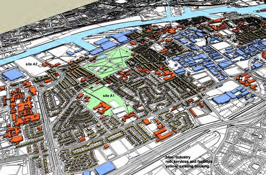
After
surveys
and
scrutiny
of
primary
data
the
urban
form,
social
and
socio-‐economic
values
and
value
profiles
of
Govan-‐Drumoyne
were
established
and
compared
with
the
target
and
threshold
values.
The
area’s
scores
do
not
even
get
close
to
most
of
the
threshold
values
below
which
an
area
is
considered
to
be
unsuitable
for
regeneration.
Two
options
were
developed.
The
more
modest
regeneration
option
investigated
a
small
rise
of
the
population
to
the
target
value
of
an
urban
quarter
in
intermediate
location
(between
centre
and
edge
of
the
city).
Due
to
the
rather
large
area
of
Govan-‐Drumoyne
the
effect
was
insignificant.
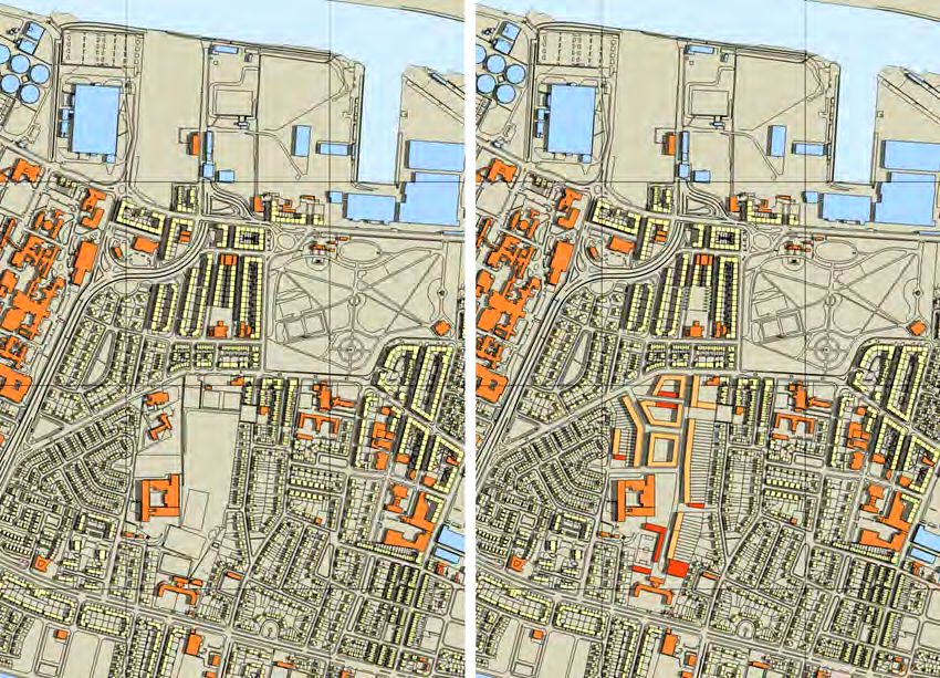
Therefore
a
more
substantial
rise
of
the
population,
resulting
from
the
partial
development
of
underused
land,
was
examined
and
this
option
scored
better
and
achieved
almost
all
average
values
of
the
sustainability
tool.
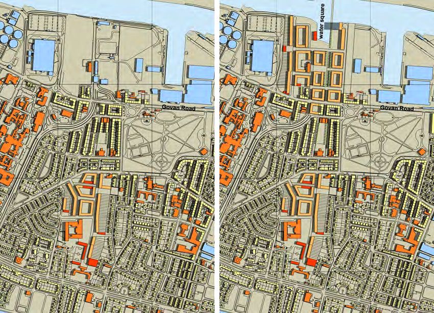
The
more
intense
regeneration
of
the
second
option
investigated
the
development
of
a
second
urban
quarter
on
the
northern
part
of
Govan-‐Drumoyne
site
and
the
disused
riverfront
site
north
of
Govan
Road.
This
option
achieved
all
target
values
of
the
sustainability
tool.
Both
options
were
diagrammatically
modelled
to
show
the
potential
impact
of
the
regeneration
options
on
the
built
form
of
Drumoyne
and
the
surrounding
areas.
The
final
test
used
the
sustainability
tool
to
investigate
two
new
urban
quarters
at
Freiburg
im
Breisgau,
Germany:
Vauban
and
Rieselfeld.
The
existing
built
form,
social
and
socio-‐economic
profiles
of
the
two
urban
quarters
were
compared
with
the
target
values
and
profiles
and
show
some
minor
discrepancies
as
a
result
of
different
priorities
for
the
two
urban
quarters,
but
otherwise
the
scores
of
both
areas
were
rather
high
as
one
would
expect.
Generally,
the
built
form
target
values
were
rather
similar
to
those
of
the
research
team.
The
Freiburg
schemes
are
both
based
on
built
form,
social
and
socio-‐economic
sustainability
concepts
as
suggested
by
the
research
team
but
include
also
ecological
concepts,
which
are
spelled
out
in
the
Summary
Report.
The
conclusions
drawn
from
the
experiences
with
the
research
project
suggest
that
the
tool
is
a
viable
instrument
despite
the
lack
of
empirical
evidence
for
many
of
the
adopted
target
values.
The
recommendation
is
a
systematic
investigation
by
a
follow-‐up
research
project
of
all
European
best
practice
cases
of
urban
development
based
on
sustainability
frameworks
like
Vauban
and
Rieselfeld
to
distil
values
that
are
underpinned
by
empirical
evidence.
The
tool,
however,
meets
considerable
barriers
and
makes
it
unlikely
that
it
will
be
applied
in
practice
before
the
new
RTPI
type
of
planning
approach
that
includes
spatial
planning
will
produce
professionals
that
can
cope
with
a
more
strategic,
and
in
the
end
also
design-‐based,
routine.
Page
5
Urbanising
Suburbia
Summary
Report
on
Research
Project
Acknowledgement
I
would
like
to
thank
Roland
Veith,
head
of
the
Vauban
Office
at
the
Building
Department
of
the
City
of
Freiburg
im
Breisgau,
for
valuable
information
on
the
planning
frameworks
for
the
urban
quarters
Vauban
and
Rieselfeld
and
for
the
provision
of
Vauban
land
use
data.
Without
your
help
I
would
not
have
found
it
easy
to
understand
the
motives
behind
and
concepts
for
these
inspiring
new
urban
quarters.
I
am
grateful
to
eRich
Lutz,
Büro
für
naturnahe
Freiflächenplanung,
Freiburg–Vauban
for
providing
much
needed
information
on
Vauban
that
helped
overcome
the
lack
of
time
for
own
surveys
and
that
unavailability
of
some
statistical
material.
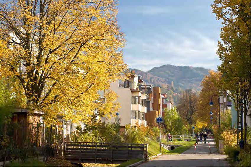
Many
thanks
to
Daniel
Schoenen,
Photographer,
Freiburg
im
Breisgau,
for
his
kind
permission
to
include
a
selection
of
his
rather
beautiful
Vauban
photographs
in
this
Summary
Report.
I
would
like
to
dedicate
the
two
reports
to
my
late
cousin
Charles.
Apologies
I
wish
to
apologise
for
the
late
publication
of
the
two
documents
Final
Report
and
The
Handbook
on
the
Urbanising
Suburbia
Research
project.
The
enormous
delay
is
due
to
family
problems
and
a
bereavement
that
made
it
extremely
difficult
for
me
to
concentrate
on
academic
work
after
moving
to
Alsace
in
2008.
This
made
it
also
difficult
to
update
information
on
the
Freiburg
Vauban
and
Rieselfeld
case
studies
and
to
edit
the
reports.
Apologies
to
the
readers
for
any
mistakes
that
may
have
crept
into
the
reports
or
have
not
been
ironed
out.
Apologies
to
Herrn
Veith
at
the
Vauban
Office
in
case
of
any
misinterpretations
of
the
information
and
data
provided
for
me;
should
you
have
any
misgivings,
let
me
know
and
I
will
make
the
necessary
corrections
and
changes.
Page
6
Urbanising
Suburbia
Summary
Report
on
Research
Project
Contents
Preface
2
Introduction
4
Acknowledgements
and
Apologies
6
Contents
7
1
Objectives
and
work
stages
of
the
research
project
9
2
The
theoretical
and
methodological
underpinning
of
the
research
project
11
2.1
Emergence
of
indicators
of
sustainable
development
11
2.2
Response
to
the
current
practice
in
urban
development
and
regeneration
12
2.3
The
promotion
of
an
urban
renaissance
and
sustainable
urban
quarters
13
2.4
Implications
of
the
growing
demand
for
additional
housing
14
• Arguments
pro
urban
intensification
14
• Arguments
against
higher
housing
densities
and
barriers
to
achieving
them
15
• Review
of
arguments
17
2.5
Conclusions
regarding
the
theoretical
underpinning
of
and
methodology
for
18
urban
regeneration
• The
lack
of
empirical
evidence
18
• The
urban
quarter
as
key
module
of
urban
districts,
the
town
and
city
19
• The
physical
form
of
the
city
as
‘modular
construct’,
where
it
still
exists
and
20
where
it
was
lost
or
had
never
developed
• Reinstating
urban
modularity
and
the
resulting
urban
form
21
References
22
3
Developing
a
tool
for
the
measurement
of
levels
of
sustainability
of
urban
areas
24
3.1
The
relevant
key
indicators
for
the
planning
and
conception
stages
of
urban
24
regeneration
• Built
form
characteristics
of
a
sustainable
urban
quarter
24
• Characteristics
of
socially
balanced
and
inclusive
urban
quarters
24
• Socio-‐economic
characteristics
of
a
sustainable
urban
quarter
25
3.2
Establishing
threshold
and
target
values
for
the
relevant
indicators
25
• Threshold
and
target
values
of
socio-‐economic
characteristics
25
• Social
characteristics,
threshold
and
target
values
of
a
socially
balanced
and
29
inclusive
urban
quarter
• Socio-‐economic
characteristics,
threshold
and
target
values
of
a
sustainable
31
urban
quarter
References
32
4
Application
of
the
tool
for
the
measurement
of
levels
of
sustainability
of
selected
33
urban
areas
4.1
The
investigation
of
suburbs
of
the
CityForm
Core
Programme
with
Glasgow-‐ 33
Darnley
as
typical
example
of
a
‘car
suburb’
4.2
The
River
Clyde
Corridor
between
Glasgow
City
Centre
and
the
Clyde
Tunnel
36
• Preliminary
investigation
of
the
Govan
areas
37
• The
relationship
of
Govan
with
new
riverfront
development
38
• The
lack
of
permeability
and
connectivity
of
the
Govan
area
39
Page
7
Urbanising
Suburbia
Summary
Report
on
Research
Project
4.3
The
detailed
investigation
of
the
Govan
Drumoyne
area
41
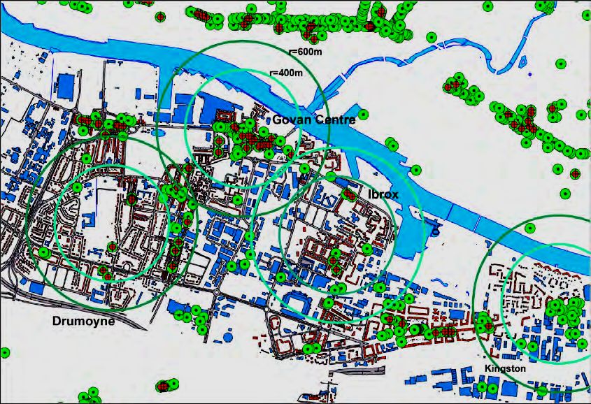
• Govan-‐Drumoyne:
investigation
of
its
current
urban
form
and
socio-‐ 41
economic
characteristics
• Investigation
of
the
modest
‘one-‐urban-‐quarter’
regeneration
scenario
for
45
Govan-‐Drumoyne
• Investigation
of
the
more
extensive
‘two-‐urban-‐quarters’
regeneration
52
scenario
4.4
Summary
of
findings
and
of
the
regeneration
programme
for
Govan-‐Drumoyne
56
References
57
5
The
investigation
of
two
best
practice
cases
at
Freiburg
im
Breisgau,
Germany:
the
58
development
of
the
urban
quarters
Vauban
and
Rieselfeld
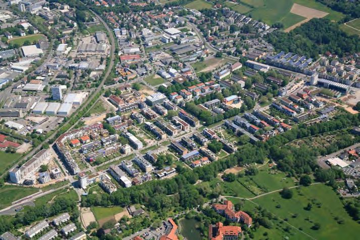
5.1
An
introduction
to
Freiburg
i.Br.
and
its
new
urban
quarters
59
5.2
A
short
summary
of
Vauban’s
development
history
61
• The
formulation
of
planning
principles
for
the
development
of
the
Vauban
61
site
• The
Vauban
project
structure
and
planning
approach
62
5.3
Comparison
of
the
key
urban
form
characteristics
of
Freiburg’s
urban
quarters
63
Vauban
and
Rieselfeld
with
research
project
target
values
• The
principal
urban
design
features
of
the
Vauban
and
Rieselfeld
schemes
63
• The
built
form
characteristics
of
Vauban
and
Rieselfeld
65
• The
key
social
characteristics
Vauban
and
Rieselfeld
69
• The
socio-‐economic
characteristics
of
Vauban
and
Rieselfeld
70
• Environmental
and
ecological
concepts
of
Vauban
73
o An
ecological
energy
concept
for
Vauban
to
reduce
CO2
73
emissions
and
protect
the
climate
o An
ecological
traffic
/
mobility
concept
for
Vauban
74
o A
sustainable
water
management
concept
for
Vauban
76
o Sustainable
concepts
for
the
design
of
public
and
semi-‐public
76
spaces
in
Vauban
o Further
illustrations
of
the
effect
of
sustainability
concepts
at
77
Vauban
5.4
What
can
be
learned
from
the
investigation
of
Freiburg’s
urban
quarters
Vauban
81
and
Rieselfeld
• The
City
of
Freiburg’s
approach
to
the
urban
development
projects
of
Vauban
81
and
Rieselfeld
• The
communalities
and
differences
of
the
’Freiburg’
and
the
‘research
81
project’
approaches
to
urban
development
and
regeneration
• What
convinces
most
at
the
urban
quarter
Vauban
82
References
83
6
Conclusions
regarding
the
formulation
of
target
values
and
their
application
in
85
theoretical
and
concrete
urban
development
and
regeneration
cases
6.1
Recommendations
of
built
form
characteristics
and
targets
for
urban
85
development
and
regeneration
6.2
The
lack
of
social
and
socio-‐economic
target
and
threshold
value
proposals
86
6.3
Barriers
to
the
balancing
of
socio-‐economic
profiles
86
6.4
The
outcome
of
the
improvement
of
urban
areas
in
pursuit
of
common
targets:
87
cloned
urban
quarters,
towns
and
cities?
6.5
Barriers
for
the
implementation
of
the
sustainability
tool
in
practice
88
Page
8
Urbanising
Suburbia
Summary
Report
on
Research
Project
Chapter
1
Objectives
and
work
stages
of
the
research
project
According
to
the
report
of
the
Urban
Task
Force
(1999,
rsh-‐p),
there
are
a
number
of
urgent
tasks
both
government
and
the
planning
system
have
to
deal
with:
• To
translate
principles
of
sustainable
urban
development
into
strategic
concepts
of
sustainable
urban
form.
• To
accommodate
the
growing
number
of
small
households.
• To
halt
and
reverse
urban
decline
specifically
of
inner-‐city
areas
and
communities.
• To
halt
and
reverse
suburban
sprawl
responsible
for
social
and
economic
decline
of
inner-‐city
areas.
In
response
to
these
tasks,
the
main
objectives
of
this
research
project
were
to
develop
a
theoretical
underpinning
of,
and
a
methodology
for,
urban
development
and
regeneration
that
would
help
transform
currently
unsustainable
urban
areas
into
sustainable
urban
quarters
(neighbourhoods,
villages).
The
key
mission
of
the
research
project
was
accordingly
to
find
ways
of
translating
the
notion
of
sustainable
development
into
strategic
concepts
of
urban
expansion
and
regeneration.
Once
this
key
task
was
achieved
the
other
tasks
of
dealing
with
urban
growth
as
well
as
restructuring
inner-‐city
and
urban
fringe
areas
would
follow
suit.
The
main
tasks
of
the
research
team
were
accordingly:
• To
scrutinise
the
emergence
of
indicators
of
sustainable
urban
development.
• To
critically
investigate
current
approaches
to
urban
regeneration
and
their
likely
achievements.
• To
analyse
the
implications
of
the
growing
demand
for
additional
housing,
the
pros
and
cons
of
urban
intensification,
and
the
development
of
new
housing
on
green-‐field
or
brown-‐field
sites.
• To
develop
a
theory
of
sustainable
urban
form
and
a
methodology
for
the
regeneration
of
existing
urban
areas.
• To
generate
a
tool
for
the
systematic
measurement
and
assessment
of
levels
of
sustainability
of
urban
areas.
• To
apply
the
tool
for
the
assessment
of
the
existing
values
and
deficiencies
of
selected
urban
areas
at
Glasgow
and
other
consortium
cities
and
formulate
regeneration
programmes
for
these
areas.
• To
translate
the
regeneration
programmes
into
two
and
three-‐dimensional
regeneration
models
and
to
test
their
achievements
and
viability.
Table
1.01
illustrates
the
original
work
stages
for
the
development
and
application
of
the
sustainability
tool.
Unfortunately,
for
reasons
outlined
in
the
concluding
part
of
this
report,
the
Glasgow-‐Govan
community
and
stakeholder
consultations
could
not
be
carried
out.
This
meant
that
it
was
not
possible
to
test
the
social
and
economic
viability
of
the
regeneration
programmes
developed
with
the
help
of
the
tool
for
three
of
the
urban
areas
of
Glasgow-‐Govan.
Consequently
a
detailed
simulation
of
the
application
of
the
tool
at
two
new
urban
quarters
of
Freiburg-‐Vauban
and
Freiburg-‐Rieselfeld
in
Germany
was
worked
out
to
have
at
least
some
evidence
that
the
tool
is
working
with
the
right
kind
of
threshold
and
target
values,
is
able
to
respond
to
individual
needs,
and
is
capable
of
detecting
the
strengths
and
weaknesses
of
ongoing
or
planned
urban
development
projects
and
guide
them
towards
more
sustainable
strategies.
The
Freiburg
case
study
is
presented
in
chapter
5
of
this
Summary
Report.
Page
9
Urbanising
Suburbia
Summary
Report
on
Research
Project
Table 1.01 Flow chart of the development and application of the sustainability tool
Sources & methods Work stages Filters & barriers
Sustainability indicators Establishing sustainability Existing values of selected
and target values from indicators & target values, (sub)urban areas (from
UN, EU. UK policies and measuring existing values surveys, data bases, from
research output of each selected area and information received by
EU & UK best practice establishing the differences local authorities and
urban regeneration and between target and existing professionals)
development cases values
Prioritisation methods Prioritising target values Local constraints in terms
Stakeholder priorities in response to local needs of existing conditions
and conditions for each of Local preferences for the
the selected areas improvement of the
selected (sub)urban areas
Data on available Establishing a regeneration 3 levels of regeneration
disused/derelict land programme for each of the Developing gap sites and
Qualitative conditions of selected areas (sub)urban disused land
existing urban fabric areas on the basis of value Developing poorly used
(especially housing) differences and local urban land and fabric
priorities & constraints Restructuring urban areas
Modelling techniques 3-D modelling of regener-
Accessibility of local ation programmes on the
services, facilities and basis of the 3 levels of
public transport regeneration, establishing
achievable values for each
selected area
Methodology for target Presentation of models to Assessment by
group sessions local communities & stake- stakeholders of the social
Workshops and local holders, modification or acceptability of models in
conferences elimination of models after target group sessions
feedback Economic and/or operative
barriers
Real house prices & rent Establishing economic Conditions and limitations
levels viability of selected of the capacity of
Demolition costs regeneration models infrastructure
Capacity of water Financial constraints
supply, sewer, power,
communication systems
Conferences Documentation and
Workshops dissemination of socially
Publications acceptable and
Reports economically viable
regeneration models
References
CityForm:
Sustainable
Urban
Form
Consortium
web
page:
www.cityfrom.org.uk.
Jenks
M.,
Jones,
C.
(eds.)
(2010)
Dimensions
of
the
Sustainable
City,
Future
City
2.
Dordrecht
Heidelberg
London
New
York:
Springer.
rsh-‐p
(Rogers
Stirk
Harbour
&
Partners)
web
page:
http://rsh-‐p.com/render.aspx?siteID=1&navIDs=1,4,22,545.
Urban
Task
Force
(1999)
Towards
an
Urban
Renaissance:
Final
Report
of
the
Urban
Task
Force.
London:
E
&
FN
Spon.
Page
10
You can also read