Commercial and Industrial Land Study - June 2020 - Whitehorse.ca
←
→
Page content transcription
If your browser does not render page correctly, please read the page content below
Commercial and
Industrial Land Study

Submitted by

                          in partnership with

to

City of Whitehorse Planning and Sustainability Services Department

                                        June 2020
This page left intentionally blank

                                     i
Executive Summary
A healthy local economy relies on the availability of a suitable mix of employment lands to support growth in key
business sectors and related employment levels and local spending. Commercial and industrial lands that support
economic activities and land uses not traditionally sited within downtown areas are a vital part of this mix.

The pending update of the 2010 Official Community Plan (OCP) by the City of Whitehorse (“the City”)
necessitated a review of the current status of and future needs for commercial and industrial lands outside of
Downtown in Whitehorse. The City hired a consulting team led by Groundswell Planning to conduct a
Commercial and Industrial Land Study, aimed at:

    •   Assessing and determining future demand for commercial and industrial land within the city (excluding
        Downtown) through to 2040;

    •   Identifying options and alternatives to meet future demand with supply (i.e. policy and/or land use
        prescriptions); and

    •   Making recommendations, including an implementation plan, for the City to consider in formulating
        relevant portions of the OCP.

This study was undertaken from Spring 2018 to Winter 2020, and included the following tasks:

    •   An inventory of current commercial and industrial land supply in Whitehorse, focusing specifically on
        areas designated in the 2010 OCP as Industrial (I), Natural Resource (NR), Mixed-Use –
        Industrial/Commercial (MU-I/C) and Future Planning (FP);

    •   A review and summary of economic trends and projections relating to commercial and industrial activity;

    •   A review of land use and regulatory considerations for the emerging and water-intensive food, beverage
        and cannabis production industries;

    •   Identification of underutilized commercial and industrial areas within Whitehorse and formulation of
        policy recommendations for optimizing use;

    •   An assessment of the development suitability of:
        o Undeveloped areas designated I and MU-I/C for industrial and commercial use;
        o Areas designated FP situated adjacent to existing areas designated I for industrial use;
        o Land parcels currently undergoing quarrying, and their potential to transition into new industrial lands;
          and
        o The Stevens Quarry area for industrial or commercial uses (versus the current NR and FP OCP
          designations).

    •   Formulation of recommendations for:
        o Improvements to planning, disposition, and monitoring processes relating to commercial, industrial,
          and quarry lands;
        o Future locations and land use mix for new commercial and industrial lands in urban and rural areas,
          including discussion on infrastructure, servicing and related considerations for cost-effective
          development;
        o Integrating food, beverage and cannabis production industries into existing or new commercial and
          industrial areas in Whitehorse; and
        o Changes to existing, and development of new, commercial and industrial areas.

                                                                                                                    ii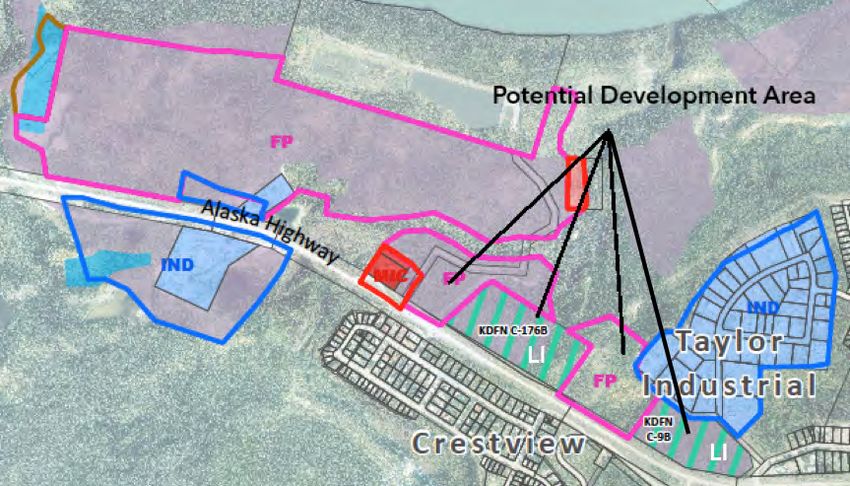
The study team engaged with a range of stakeholders to better understand current and future requirements and
market conditions for commercial and industrial lands. Engagement efforts included a business/property owner
survey, focus group sessions with local business and industry representatives, and interviews with First Nation
governments and development corporations, realtors, developers, industry associations, and the Government of
Yukon (YG).

Approximately 973 and 462 hectares of land within municipal boundaries are designated I and MU-I/C, respectively.
These designations and the four zones that fall under them – specifically IH - Heavy Industrial, IS - Service
Industrial, CH - Highway Commercial, and CIM - Mixed-Use Commercial/Industrial – are primarily located outside
of Downtown and residential areas. An additional 289 and 3895 hectares of land designated NR and FP1,
respectively, are potential candidates for accommodating future private sector growth. Settlement Lands of the
Kwanlin Dün First Nation (KDFN) and Ta’an Kwäch’än Council (TKC) are also potential future contributors to
the commercial and industrial land supply; the former designated First Nation Future Planning and the latter falling
under other OCP designations.

              Land Use Designations and Zones                            Total      Total Area –      Total Area –       # of
                                                                                                                              2
                                                                         Area       Other Lands       First Nation       Lots
                                                                          (ha)          (ha)           Land (ha)
 INDUSTRIAL (I)                                                          972.9         969.5               3.5              -
 IH – Heavy Industrial                                                    66.2          66.2                -              33
 IS – Service Industrial                                                 265.3         239.1              26.2            213
 MIXED-USE – INDUSTRIAL/COMMERCIAL (MU-I/C)                              461.9         445.8              16.1              -
 CH – Highway Commercial                                                  95.2          90.2                5              77
 CIM – Mixed-Use Commercial/Industrial                                   140.8         123.1              17.7            254
 NATURAL RESOURCE (NR)                                                   288.6         288.6                -               -
 IQ – Quarries                                                           449.5         449.5                -               -
                            4
 FUTURE PLANNING (FP)                                                   3895.3         3866               29.3              -
 FP – Future Planning5                                                   4133         4102.7              30.3              -
                                       6
 FIRST NATION FUTURE PLANNING (FNFP)                                      294             -                294              -
 FNFP – First Nation Future Planning7                                      1.8           0.8                1               -

Currently, I and MU-I/C designated lands are distributed in various nodes around Whitehorse, most of which are
oriented directly on or in proximity to the Alaska Highway. Nodes of heavier industrial activity include the Kulan,
Taylor, Mount Sima, and MacRae industrial areas, which are generally serviced with gravel roads and
Internet/telephone, but are not connected to municipal water or sewer. MU-I/C designated lands are found along
the Alaska Highway throughout much of Whitehorse, and are also concentrated in several nodes in Marwell, north
of Downtown, along Range and Burns roads near the airport, and Metropolit Lane at the intersection of the
highway and Robert Service Way/Hamilton Boulevard. With the exception of Marwell and a few other nodes
situated off the Alaska Highway, most of these lands are not serviced with municipal water and sewer.

There are also about 450 hectares of land zoned IQ – Quarries within the municipality, the vast majority of which
are Commissioner’s lands leased to quarry operators by YG’s Land Management Branch. Gravel quarry approval
and management on Commissioner’s lands is administered under the Lands Act Quarry Regulations. The City is
consulted prior to the issuance of testing and quarry permits to ensure OCP and zoning conformance.

1 Only  FP designated lands located adjacent to MU-I/C and I designated areas were examined in this study.
2 This includes unconsolidated land parcels that comprise larger properties as well as vacant lots.
3 The majority of IH zoned land is comprised of lease areas, some with split zoning. Three lots (6.5 ha) are privately owned.
4 This includes only those FP designated areas located adjacent to I and/or MU-I/C designated areas.
5 This includes only FP zoned areas located within the FP designated areas adjacent to I and/or MU-I/C designations.
6 This designation is specific to KDFN lands; TKC lands are incorporated into the FP designation. Only those FNFP areas

located adjacent to I and/or MU-I/C designated areas are included in this total.
7 This includes only FNFP zoned areas located within the FNFP designated areas adjacent to I and/or MU-I/C designations.

                                                                                                                                iii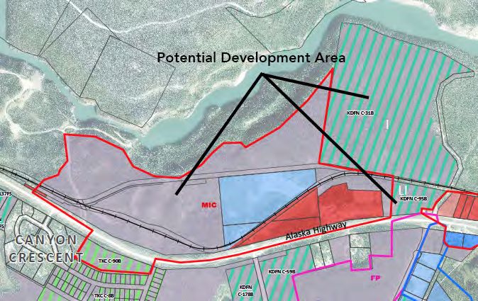
The past 20 years have seen only a handful of Whitehorse commercial lots released to market by YG8. Over 50
industrial lots were released in the two phases of the Mount Sima industrial subdivision in the early to late 2000s.
A private development in the Marwell area released almost 50 CIM zoned lots between 2007 and 2017. In the past
two decades of government-led lot sales, both commercial and industrial lot prices have trended moderately
upwards, while the sales period sharply decreased around the peak of the commodities “supercycle” between
2010 and 2013 that saw elevated mineral prices and accompanying exploration and production activity.

The majority of the approximately 205 development applications received by the City during the 2009-2018
timeframe in the zones of study interest involved development permits for IS and CIM zoned parcels. About 80%
of permits were triggered by new construction, with redevelopment (i.e., additions or renovations) comprising the
remaining 20% or so. Caretaker residences comprised just over one quarter of IS permit applications.

Realtors, First Nation development corporations, and private developers told the project team heard that demand
can be difficult to accurately pinpoint but is felt to have increased over the past several years. Demand is
particularly high for the Titanium Way model of development (i.e., small lots, multi-unit buildings, ground-floor
shops with second storey office space, etc.) and, to a lesser extent, larger land parcels suitable for larger format
rental/retail businesses and equipment and materials storage. Interviewees described market supply as very limited
and costs as steadily increasing, owing to a variety of factors that include a lack of raw land sales, the high costs of
retrofitting existing outmoded properties for the specific needs of business, and older properties functioning as
“junkyards” likely in avoidance of municipal landfill tipping fees.

Property owners and business operators shared similar insights, citing land availability and affordability as critical
challenges to the private sector. About one third of the 39 respondents to the project’s online survey indicated
plans to relocate and/or expand onto another Whitehorse property in the next decade, with a similar proportion
indicating plans to expand buildings or business activity on their current property. Almost all of the respondents
who indicated they were currently seeking a new property described the supply of commercial and industrial lots
as either “limited” or “non-existent”. Property seekers expressed a preference for CIM zoning, a mix of lot sizes,
and lots with municipal water and sewer. They also emphasized that land ownership was strongly preferred over
leasing and/or rental arrangements.

The future demand for commercial and industrial lands will be dictated by both macro and micro-economic
conditions impacting Whitehorse. The Yukon’s economy is heavily dependent on public sector activity, and this
sector has shown steady growth over the past fifteen years. Private sector performance is typically linked to the
performance of the mining sector in particular; not surprisingly, there was a notable decline in most industries as
mineral exploration and production in the territory sharply dropped post-2013. However, Gross Domestic
Product (GDP) from most private sector-oriented industries has since steadily increased from 2014-2016 lows
and, as of 2018, slightly surpassed those previous highs, despite the fact that mining-related GDP is still at pre-
“boom” levels, suggesting that public sector spending, and possibly broader regional population growth, is as much
a contributor.

Economic forecasting for the territory would suggest that another cycle of high mineral exploration and
production can be expected over the 2020-2030 timeframe, buoyed by Victoria Gold’s Eagle mine coming online
and the reasonable likelihood of the Coffee Gold mine project following suit within the next few years. Meanwhile,
population projections indicate that the greater Whitehorse area will be home to about 44,650 residents by 2040.

Using the overarching assumptions that future economic growth (or decline) in industry sectors requiring
commercial and industrial lands will be fairly consistent with the 2008-2018 timeframe and that the public sector
will continue to buffer the economic fluctuations induced by cyclical mining sector activity, an estimated 87 and 32
hectares of raw land will be required by 2040 with l and MU-I/C designations, respectively. These land need
predictions factor in the team’s best estimate of 2019 latent demand and incorporate a range of assumptions
around the distribution of certain industries between Downtown, residential neighbourhoods, and I and MU-I/C
designated areas.

8 YG   has primary responsibility for land development (surveying, infrastructure, and sales) in Yukon.

                                                                                                                         iv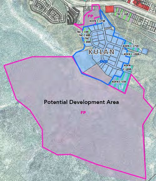
2030 Land Demand (ha)          20409 Land Demand (ha)
                                                                  MU-I/C         I               MU-I/C         I
    Future Demand – All Relevant Industry Sectors                   9.7         18                 18.3        33.9
    2019 Latent Demand                                              5.8        31.5                 5.8        31.5
    TOTAL – Land Demand (Net)                                      15.5        49.5                24.1        65.4
    TOTAL – Land Demand (Gross)                                    20.6        66.0                32.1        87.2

There are multiple options for meeting that anticipated requirement for 120 gross hectares of MU-I/C and I
designated lands over the next 20 years, including infill of already developed areas, redevelopment, and greenfield
development.

Approximately 3784 hectares of undeveloped lands in Whitehorse are designated MU-I/C and I and/or are located
adjacent to areas with these designations. Of these candidate lands, 58% have good, or good with some
constraints, development potential. Approximately 8% and 18% of lands with good, or good with some constraints,
development potential are already designated MU-I/C and I, respectively, and over 25% is First Nation Settlement
Land10.

First Nation Settlement Lands account for 11% of candidate lands for future commercial and industrial
development. In many cases these parcels are located in highly strategic areas, making them critical pieces in the
medium and long-term Whitehorse development puzzle. After YG, KDFN is the largest landowner in the
municipality, and commercial and industrial land uses are envisioned for over 50% of its Type 2 parcels situated
within Whitehorse. Relatively recent legislative efforts by both KDFN and YG now allow for the registration of
leasehold interests on First Nation lands on the territory’s land registry. KDFN’s Chu Níikwän Development
Corporation is actively seeking private sector tenants and lessees for some of its Settlement Lands; TKC, however,
is not at this time.

Infill development of lands located within, and/or immediately adjacent to, already developed industrial and
commercial nodes could potentially provide about 80 hectares of raw land, of which almost two-thirds is under
Commissioner’s and/or City ownership, and of that, a little over half are both appropriately designated and zoned
already. These 80 hectares of infill potential could almost completely satisfy 2030 requirements and about three-
quarters of 2040 requirements, with some exceptions. Site utilization across Whitehorse’s developed industrial
and commercial lots of interest is typically in the 80-100% range, indicating relatively little potential for substantive
redevelopment and/or densification of existing nodes. The City’s experiences to date with attempting to bring
municipal servicing to currently unserviced areas suggests that property owners are very reluctant to incur the
associated costs once they have already invested in on-site solutions, even with the prospect of higher site
utilization. The unserviced Kulan and Taylor industrial areas are within reasonable proximity of City water and
sewer infrastructure; however, the already very high utilization of lots in these areas suggests minimal potential for
subdivision and the creation of new lots should they be connected to municipal services.

On the balance of numerous high-level suitability criteria, including estimated development costs, impacts on
recreational and environmental values, and potential synergies with residential and/or Settlement Land
development, the project team concluded that the most favourable development conditions currently exist for the
“MacRae East” area for unserviced industrial land development and the “Taylor North” and “Hillcrest South” areas
for serviced commercial development. The area at the intersection of Robert Service Way/Hamilton Boulevard
with the Alaska Highway could also be a highly strategic greenfield area to develop if bedrock constraints can be
overcome in a cost-effective manner.

Potential brownfield conversion of gravel quarries to commercial and industrial lands is theoretically possible but
virtually impossible to properly plan for within the current YG administrative and permitting regime. Monitoring of
quarry activity is limited to conformance with issued permits and lease conditions, not progress made towards the
fulfillment of the initial quarry plan. Further, there is no continuous or intentional record keeping around annual
extraction quantities. Practical experience with both the Ear Lake and McLean Lake quarries to date would suggest

9Inclusive of 2030 demand.
10The inclusion of First Nation lands in the development suitability analysis was triggered by adjacency to OCP designated areas
versus specified development intent. This figure is a very rough guideline for discussion purposes.

                                                                                                                               v
that initial pit life estimates can be far exceeded. There is a need to revisit, and possibly redesign, the administrative
regime for quarry management within Whitehorse to achieve better long-term land use planning, land use
efficiency, and possibly achieve higher utilization through the facilitation of third party interim uses in pit areas that
have been exhausted but are still under lease for quarrying.

The former Whitehorse Copper mine site and the Stevens Quarry area are two large undeveloped areas with
potential suitability for future commercial and industrial activity but are subject to a host of complicating factors.
Given the need for a substantial future gravel resource located close to City limits, the absence of suitable
alternatives, and the fact that industrial lots could be provided with fewer land use conflicts (and presumably
opposition) in other areas of Whitehorse, there is no sound rationale to re-designate the Stevens Quarry area for
commercial and/or industrial purposes at this time. The Whitehorse Copper site has been privately leased since
2011. The original lessee intended to reprocess old tailings and reclaim the Old Pond area, currently zoned Heavy
Industrial, to a potential industrial area. However, the reprocessing project fell through and closer examination of
the caveats originally made around reclamation suggest that a more concerted government effort and possible
creative private-public sector approaches should be considered if this area is ever to properly function as industrial
land.

Areas of economic growth that future commercial and industrial lands will need to accommodate are the food,
beverage and cannabis production sectors. Zoning approaches across North America have shifted to better
integrate food and beverage production into urban areas, in many cases blurring the lines between industrial and
agricultural activity. Some of these zoning approaches include the creation of specific definitions and even zones to
accommodate production activities, often varying on the basis of whether production is indoor or outdoor and
whether there are associated retail uses. Some Western Canadian municipalities now allow for the full spectrum of
indoor food production activities in some Downtown, commercial, and industrial areas. Similarly, breweries and
distilleries have expanded beyond their industrial area beginnings, with craft-level producers generally allowed
within commercial zones and associated retail and lounge functions being permitted in industrial locations.
Cannabis production is a relative newcomer and larger western Canadian municipalities are generally restricting
such operations to industrial areas.

Local growers, industry associations, and government representatives involved with agriculture described a local
food and beverage sector that is both growing and maturing due to healthy local interest and demand. They
stressed the need for a supportive land use regime as well as the reduction of barriers throughout the production
chain – including a shift to integrated management of waste streams. Land availability and affordability were cited as
key determinants to where the sector locates, along with infrastructure such as three-phase power, Internet, and
access to transit. Similar to other industry sectors, the ability to generate additional revenue and secure labour
resources with caretaker residences was desired, as was stacked land-use allowances that allow for on-site
production, retail, and tasting functions.

Currently, the City’s Zoning Bylaw indirectly captures uses such as indoor agriculture, breweries, and food/beverage
processing through generalized use definitions. The emergence of such water and wastewater intensive uses in
rural, unserviced areas has created unique challenges for the City and other regulators and highlighted ambiguities
and potential gaps in the regulatory framework. The City and partners should endeavour to better understand and
define water-intensive land uses (which additionally include car washes and caretaker residences) and develop a
regulatory framework that is both supportive of industry and protective of public health and the environment. The
restriction of water-intensive industries to serviced areas is one potential strategy to consider. Intensity thresholds
for unserviced areas could also be explored to develop precautionary zoning regulations.

While the team concludes that there is little risk of a gap between land supply and demand on a land quantum
basis, it encourages both the City and YG to take a more strategic, investment-oriented view on how land should
be developed moving forward. The respective roles and responsibilities of public and First Nation governments in
meeting market demand will need to be delineated and coordinated in a manner that meets a balance of private
sector needs and preferences, the spirit and intent of the final agreements involved, and sound land use policy.
Commercial and industrial lands within the Urban Containment Boundary (UCB) established in the 2010 OCP
should be prioritized for fully serviced, higher value and higher density development that is integrated with
residential areas (where appropriate) and employment-supportive amenities. These areas will become the future
home of businesses and industries that become gradually outmoded in Downtown and Marwell as they evolve in

                                                                                                                        vi
the manner envisioned in the City’s recent long-range plans for both. At the same time, industrial activities –
particularly those of a “nuisance” nature – need to be adequately protected through zoning and appropriately
sited.

Recovering the higher costs of serviced development supports the idea of pursuing Whitehorse’s next major
residential subdivision in the Southern UCB (SUCB) area located to the west of the Alaska Highway between
Copper Ridge and McLean Lake, an option the City investigated in 2017. While the City has relatively little control
over land prices, it can potentially push the affordability needle for business and property owners through land use
controls that maximize income generation and/or cost savings – specifically greater flexibility around caretaker
residences in areas where the priority test of compact, higher value (i.e., serviced) development can be met.

The project team offers the following recommendations for the City to consider:

Process and Partnerships

    1.   In cooperation with YG, institute a moratorium on spot land applications for commercial and/or industrial
         use within City limits to facilitate more comprehensive development that optimizes existing and future
         servicing and addresses a broader spectrum of market needs. The notable exception to this
         recommendation is the consideration of spot land applications for heavy industrial uses that can not be
         accommodated elsewhere due to noxious impacts;
    2.   Establish a process to formalize collaboration and coordination around land development between the
         City, YG, and KDFN and TKC, respectively. The process deliverables, ideally Memorandums of
         Understanding (MOUs), should provide guidance to the signing parties with respect to:
          a. Roles and responsibilities in regards to land development and supply for the private sector;
          b. Potential mechanisms for cost and/or capacity sharing that could be utilized to advance development
             of higher priority (and value) parcels located within the UCB; and
          c. Potential mechanisms and/or thresholds for ensuring a balance of land ownership and First Nation
             land leasing opportunities are available to the private sector (as appropriate to each First Nation).

    3.   Upon the anticipated 2020 renewal of the quarry leases for the former Whitehorse Copper Mine site,
         advocate for more detailed study and clarification of the technical issues enabling and/or precluding future
         conversion to fully productive industrial lands;
    4.   Work with YG to update the quarry administration system to better monitor quarry progress and inform
         land use planning, and explore potential mechanisms for accommodating interim uses in quarried areas;

O fficial Com m unity Plan Update

    5.   Retain the MU-I/C and I designations for undeveloped areas outlined in the 2010 OCP;
    6.   Should the SUCB area be designated for residential development, consider a re-designation of the McLean
         Lake quarries to FP to reserve a broader range of future land use options;
    7.   Subject to the identification of more suitable (and/or extensive) granular sources, retain the NR
         designation for the Stevens Quarry area;
    8.   Consider the re-designation of a portion of the FP designated area located between “Taylor North” and
         Forestview on the east side of the Alaska Highway to I to accommodate heavy industrial activity over the
         long-term;

                                                                                                                   vii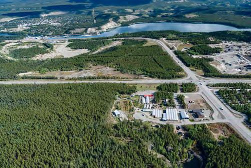
Zoning Bylaw Update (Post-O CP adoption)

   9.   Extend I and/or CIM zoning to areas currently zoned FP in Mount Sima and Range Road as a precursor to
        infill development;
   10. Increase the number of caretaker residences permitted on serviced IS, CH, and CIM zoned lots while
       protecting primary employment uses;
   11. Maintain current caretaker residence allowances for IS, CH, and CIM zoned lots in unserviced areas and
       consider instituting occupancy-oriented restrictions, subject to the findings of the research described in
       #30;
   12. Subject to the findings of the research outlined in #30, consider increasing minimum lot size requirements
       in unserviced areas to reflect commercial/industrial uses combined with caretaker residence use;
   13. Create new Zoning Bylaw definitions to address indoor agriculture (food and cannabis), beverage
       production and processing (breweries and distilleries). Consider instituting impact and intensity related
       thresholds contingent on location and servicing;
   14. Consider creating new definitions for other water/wastewater-intensive commercial and industrial uses
       not listed above (i.e., car washes) and review their suitability for unserviced areas;
   15. Consider mechanisms, such as thematic districts, to encourage the “clustering” of food and beverage
       production uses in targeted areas of Marwell and Downtown;
   16. Consider extending the “studio” use to the CIM zone to better accommodate artisanal and small-scale
       manufacturing;
   17. Reconsider zoning regulations that unnecessarily restrict the ability of entrepreneurs to base more than
       two businesses from one address, where no discernible change in impacts to adjacent property owners
       will result;
   18. Review purposes, uses and associated definitions for the IS and IH zones for fairness, consistency and
       adequate protection and accommodation of “nuisance” industrial activities;
   19. Ensure mapping data consistency between zones and their “parent” OCP designated areas;

Underutilized and Infill Lands (Shorter Term Land Developm ent)

   20. Consider a short-term incentive program (i.e., tipping fee relief) to encourage the clean-up and sale of
       industrial properties functioning as “junkyards” within Whitehorse;
   21. Work with YG, First Nations, and private sector interests to initiate implementation of the heavy industry
       relocation aspects of the 2018 Marwell Plan and ensure the plan’s objectives are factored into institutional
       capital planning efforts;
   22. Work with private owners of large land parcels in Marwell to explore options for subdivision that would
       quickly bring new lots in this area to market;
   23. Work with YG and First Nation landowners to expedite the planning, subdivision, surveying and
       disposition of infill lots in:
         a. MacRae
         b. Range Road
         c. Mount Sima
         d. Kulan (subject to the identification of an alternate snow dump location)
        Infill development should provide a mix of medium (~0.5 ha/~1 ha for serviced/unserviced) and large (~1
        ha/2+ ha for serviced/unserviced) lot sizes, and lots accessible off of Mount Sima Road should be
        considered for CIM zoning (versus I). YG should be encouraged to test and adapt alternative tender

                                                                                                                   viii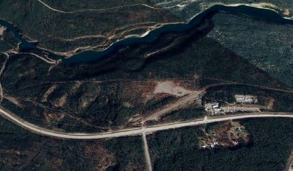
approaches to reduce development costs and avoid unnecessary escalation of lot pricing. The inclusion of
             IH zoned lots in industrial infill areas should be considered;
       24. Explore the potential for lot expansions, reviewed at the neighbourhood-level to allow cohesive planning
           that considers surrounding recreational and wildlife values;

Greenfield Developm ent (M edium to Longer Term Land Developm ent)

       25. To provide new serviced MU-I/C designated lots post-infill development, work with YG, KDFN, and TKC
           to:
               a. Select and/or prioritize development between the two options of “Hillcrest South” and (portions of)
                  “Taylor North” for MU-I/C lands;
               b. Undertake initial development due diligence for the higher priority/preferred areas; and,
               c. Establish a charter or MOU to pursue co-development of priority MU-I/C-designated
                  Commissioner’s land and adjacent Settlement Lands, with the aim of bringing new lots to market in
                  the late 2020s11;
       26. To provide new serviced I designated lots post-infill development, work with YG and KDFN to undertake
           initial development due diligence and potential co-development for the “Taylor North” area, with the aim
           of bringing new lots to market in the late 2020s to early 2030s;
       27. To provide new unserviced I designated lots post-infill development, work with YG to:
               a. Undertake further planning and prioritization work to confirm the “MacRae East” and/or “Utah”
                  area, including discussions with KDFN, TKC and White Pass and Yukon Route railway about their
                  development interests;
               b. Undertake initial development due diligence for the “MacRae East” and/or “Utah” area;
               c. Pursue co-development, utilizing a charter or MOU approach with any additional parties, of the
                  “MacRae East” and/or “Utah” area, with the aim of bringing new I lots to market in the mid-2030s12;

Servicing and Services

       28. Work with the YG to adopt interim “precautionary principle” based mechanisms to address industrial and
           commercial wastewater in unserviced areas;
       29. Ensure that capital upgrades to the Alaska Highway corridor through central Whitehorse are supportive
           of current and future employment land integration with public transit and active transportation options;
       30. In partnership with YG, undertake a risk-based assessment of allowing water/wastewater intensive and
           contaminant-generating uses in serviced and unserviced areas and identify precautionary policy and
           regulatory measures;
       31. Encourage landowners sited along the lower elevations of Bennett and Laberge roads in Kulan to connect
           to municipal water service in support of industry diversification;

Perm itting and Business Support

       32. Consider aligning City business permit administration with the North American Industry Classification
           System to allow for finer-grained (and nationally comparable) industry monitoring, and instituting a new
           category; and

11   Subject to full utilization of infill potential; should this not occur, timelines should theoretically advance.
12   Subject to full utilization of infill potential; should this not occur, timelines should theoretically advance.

                                                                                                                       ix
33. Expand upon previous work around water/wastewater intensive and contaminant-generating uses,
including potential updates to the Sewer and Storm Utility Bylaw and the development of sector-oriented
information and application packages.
xTable of Contents
1.0 INTRODUCTION 1
1.1 PURPOSE AND SCOPE 1
1.2 STUDY METHODOLOGY 1
1.2.1 Engagement Process 2
1.2.2 Land Needs Estimate 3
1.2.3 Development Potential Analysis 3
1.2.4 Industrial Area Survey 3
2.0 LAND INVENTORY 4
2.1 DESIGNATIONS AND ZONES 4
2.2 LAND USES AND RESTRICTIONS 4
2.2.1 Commercial and Industrial Zones 4
2.2.2 Quarries 6
2.3 COMMERCIAL AND INDUSTRIAL NODES 7
2.4 QUARRIES 10
3.0 HISTORICAL AND CURRENT MARKET DYNAMICS 11
3.1 PREVIOUS LOT SALES 11
3.2 BUILDING PERMITS 11
3.3 PROPERTY TRANSACTIONS 13
3.4 DEVELOPMENT APPROVALS 13
3.5 CURRENT MARKET NEEDS AND DEMAND 15
3.5.1 What We Heard – Development Community 15
3.5.2 What We Heard – Property Owner and Business Operator Focus Group Sessions 16
3.5.3 Property Owner and Business Operator Survey 17
3.6 EMERGING MARKET NEEDS AND DEMAND – FOOD, BEVERAGE AND
CANNABIS PRODUCTION 19
3.6.1 What We Heard 19
3.6.2 Cross-Jurisdictional Review 21
3.6.3 Whitehorse Zoning 22
3.6.4 Water and Wastewater 22
3.6.5 Other Considerations 23
4.0 LAND NEEDS FORECAST 24
4.1 MACRO-ECONOMIC TRENDS 24
4.1.1 Gross Domestic Product 24
4.1.2 Population Growth 25
4.1.3 Economic Forecasts 26
4.2 INDUSTRY TRENDS 26
4.2.1 Local Industry Growth 26
4.2.2 National Trends 27
4.2.3 What We Heard – Development Community 28
4.3 PROJECTED LAND NEEDS BY INDUSTRY SECTOR 29
xi5.0 FUTURE LAND SUPPLY OPTIONS 31
5.1 MAXIMIZING EXISTING DEVELOPMENT 31
5.1.1 Infill 31
5.1.2 Redevelopment 32
5.1.3 Enhanced Servicing 32
5.2 GREENFIELD DEVELOPMENT 33
5.2.1 Inventory of Candidate Lands 33
5.2.2 First Nation Settlement Lands 33
5.2.3 Potential New Serviced Areas 34
5.2.4 Potential New Unserviced Areas 40
5.2.5 Overall Development Suitability 42
5.3 BROWNFIELD DEVELOPMENT 42
5.3.1 Gravel Quarries 42
5.3.2 Stevens Quarry Area 45
5.3.3 Whitehorse Copper Site 45
5.4 SUPPLY-DEMAND COMPARISON 46
6.0 KEY ISSUES AND CONSIDERATIONS 47
6.1 PRIVATE SECTOR PREFERENCES 47
6.1.1 What We Heard – Focus Group Sessions 47
6.1.2 What We Heard – Property Owner/Business Operator Survey 48
6.2 STRATEGIC LAND DEVELOPMENT 49
6.2.1 Coordination with First Nations 49
6.2.2 Compact and Higher Value Development 49
6.2.3 Preserving Choice 50
6.2.3 Achieving Affordability 50
6.2.4 Downtown and Marwell Evolution 50
6.2.5 Relationship to Residential Land Development 51
6.2.6 Climate Change Mitigation and Adaptation 52
7.0 CONCLUSIONS AND RECOMMENDATIONS 53
REFERENCES 59
Photo Credits: All photos copyright Groundswell Planning unless otherwise noted
xiiList of Appendices
APPENDIX A. DESIGNATIONS, ZONING AND LAND TENURE MAPS 63
APPENDIX B. SUMMARY NOTES: FOCUS GROUP SESSIONS 1 (HIGHWAY
COMMERCIAL AND MIXED-USE COMMERCIAL/INDUSTRIAL
LANDS) AND 2 (SERVICE INDUSTRIAL LANDS) 71
APPENDIX C. PROPERTY OWNER AND BUSINESS OPERATOR SURVEY
RESULTS 81
APPENDIX D. SUMMARY NOTES: FOCUS GROUP SESSION 3 (FOOD,
BEVERAGE AND CANNABIS PRODUCTION SECTORS) 98
APPENDIX E. CROSS-JURISDICTIONAL REVIEW OF FOOD, BEVERAGE AND
CANNABIS PRODUCTION ZONING APPROACHES 105
APPENDIX F. DETAILED LAND DEMAND CALCULATIONS 110
APPENDIX G. DETAILED DEVELOPMENT POTENTIAL ANALYSIS
METHODOLOGY 117
APPENDIX H. DEVELOPMENT POTENTIAL MAPS 121
APPENDIX I. SERVICING PRELIMINARY CONCEPTUAL MAPS 129
xiiiList of Figures
Figure 1. Kulan Industrial Area 7
Figure 2. Alaska Highway Commercial Services Strip near Airport 8
Figure 3. Titanium Way Development in Marwell 8
Figure 4. Metropolit Lane at Intersection of Alaska Highway with Hamilton Boulevard and
Robert Service Way 9
Figure 5. Mount Sima Industrial Area 9
Figure 6. Highway Commercial Zoned Properties Fronting the Alaska Highway in MacRae 10
Figure 7. YG Commercial and Industrial Lot Sales in Whitehorse: 1997-2018 11
Figure 8. Number and Value of Commercial and Industrial Building Permits in Whitehorse:
2009-2018 12
Figure 9. Number and Value of Whitehorse Industrial Real Estate Transactions: 2008-2018 13
Figure 10. Number and Value of Whitehorse Commercial Real Estate Transactions: 2008-2018 14
Figure 11. Current Supply of Commercial Lots According to Survey Respondents 17
Figure 12. Current Supply of Industrial Lots According to Survey Respondents 17
Figure 13. Property/Business Plans of Survey Respondents 18
Figure 14. Preferred Zoning for Lots in Demand from Survey Respondents 18
Figure 15. Lot Features in Demand by Survey Respondents 18
Figure 16. Yukon GDP Total, All Industries: 2009-2018 24
Figure 17. Yukon GDP, Selected Industries, and % Increase: 2009-2018 24
Figure 18. Whitehorse Population and Population Growth Rate: 2009-2018 25
Figure 19. Number of Yukon Businesses by Industry Sector and % Increase: 2008-2017 26
Figure 20. Number of Yukon Employees by Industry Sector and % Increase: 2008-2018 27
Figure 21. Marwell Industrial Area with Early Titanium Way Development in Foreground 28
Figure 22. Breakdown of KDFN Type 2 Parcels by Intended Land Use 34
Figure 23. Map of Potential Development Area for “Taylor North” 35
Figure 24. Potential Development Area for “Taylor North” 35
Figure 25. Map of Potential “Kulan West” Development Area 36
Figure 26. Potential “Kulan West” Development Area 36
Figure 27. Map of Potential Kopper King Development Area 37
Figure 28. Potential Kopper King Development Area 37
Figure 29. Map of Potential “Hillcrest South” Development Area 38
Figure 30. Potential “Hillcrest South” Development Area 38
Figure 31. Map of Potential Robert Service Way Development Area 39
Figure 32. Potential Robert Service Way Development Area 39
Figure 33. Map of Potential Development Area for “MacRae East” 40
Figure 34. Potential Development Area for “MacRae East” 40
Figure 35. Map of Potential Development Area for “Utah” 41
Figure 36. Potential Development Area for “Utah” 41
Figure 37. Ear Lake Quarry Area 44
Figure 38. Land Supply Strategies Preferred by Survey Respondents 48
xivList of Tables
Table 1. Inventory of Whitehorse Lands Included in the Study Area 4
Table 2. Principal Uses for Commercial and Industrial Zones Included in the Study Area 5
Table 3. Secondary and Conditional Uses for Commercial and Industrial Zones Included in the
Study Area 6
Table 4. Minimum Lot Sizes and Coverage Allowances for Commercial and Industrial Zones
Included in the Study Area 6
Table 5. Principal, Secondary and Conditional Uses for the IQ - Quarries Zone 7
Table 6. Quarries Located Within City Limits 10
Table 7. YG Commercial and Industrial Land Sales, 1997-2016 12
Table 8. City of Whitehorse Development Approvals, By Type, 2009-2018 14
Table 9. City of Whitehorse Mixed-Use Commercial/Industrial and Service Industrial Zone
Development Permits, By Type, 2009-2018 15
Table 10. Projected Industry Needs for MU-I/C and I Designated Lands, 2030 and 2040 30
Table 11. Select Infill Opportunities for Commercial and Industrial Land Supply 31
Table 12. Estimated Servicing Costs for Taylor and Kulan Subdivisions 32
Table 13. Overview of Potential Candidate Lands for Future Commercial and Industrial Activity 33
Table 14. Estimated Development Costs for “Taylor North” 35
Table 15. Estimated Development Costs for “Kulan West” 36
Table 16. Estimated Development Costs for Kopper King Area 37
Table 17. Estimated Development Costs for “Hillcrest South” 38
Table 18. Estimated Development Costs for Robert Service Way 39
Table 19. Estimated Development Costs for “MacRae East” 40
Table 20. Estimated Development Costs for “Utah” 41
Table 21. Broader Development Suitability of Candidate Greenfield Areas 43
Table 22. 2040 Supply – Demand Comparison 46
List of Frequently Used Abbreviations
CIM Mixed Use Industrial/Commercial IQ Quarries
CH Highway Commercial KDFN Kwanlin Dün First Nation
FNFP First Nation Future Planning MOU Memorandum of Understanding
FP Future Planning MU-I/C Mixed Use - Industrial/Commercial
GDP Gross Domestic Product NR Natural Resource
I Industrial OCP Official Community Plan
IH Heavy Industrial TKC Ta’an Kwäch’än Council
IS Service Industrial UCB Urban Containment Boundary
YG Government of Yukon
xv1.0 INTRODUCTION
1.1 Purpose and Scope
A healthy local economy relies on the availability of lands that can accommodate the range of commercial and
industrial activity and employment not traditionally sited in downtown areas. Such lands house primary, secondary,
and tertiary economic sectors that extract and produce raw materials, manufacture and/or assemble goods, and
provide services to both local and regional populations. In Whitehorse, commercial and industrial lands outside of
the downtown core are home to a wide range of businesses that serve Whitehorse residents, the public sector,
and local and regional private sector players such as the mining industry.
The provision of commercial and industrial lands is a priority for the City of Whitehorse (“the City”) and is
supported in numerous City documents including the 2010 Official Community Plan (OCP), 2015 Community
Economic Development Strategy, and 2016 Whitehorse Sustainability Plan. The 2016 Downtown Retail and
Entertainment Strategy and 2018 Downtown and Marwell plans filled in information gaps and set a 20-year vision
for these vital retail/commercial and industrial employment areas. In preparing for the 2020 update of the OCP,
the City again wished to examine the status of commercial and industrial lands outside of the downtown area.
The City hired a consulting team led by Groundswell Planning to undertake a Commercial and Industrial Land
Study aimed at:
• Assessing and determining future demand for commercial and industrial land within the city (excluding
Downtown) through to 2040;
• Identifying options and alternatives to meet future demand with supply (i.e. policy and/or land use
prescriptions); and
• Making recommendations, including an implementation plan, for the City to consider in formulating
relevant portions of the OCP.
Whitehorse is located in southern Yukon, within the traditional territories of the Kwanlin Dün First Nation and
Ta'an Kwäch'än Council. The City, Government of Yukon (YG), and both local First Nations are governing bodies
within the municipality, each having potential influence on the future supply and mix of commercial and industrial
lands.
1.2 Study Methodology
This study was undertaken from Spring 2018 to Winter 2020, and included the following tasks:
• An inventory of current commercial and industrial land supply in Whitehorse, focusing specifically on
areas designated in the 2010 OCP as Industrial (I), Natural Resource (NR), Mixed Use –
Industrial/Commercial (MU-I/C) and Future Planning (FP);
• A review and summary of economic trends and projections relating to commercial and industrial activity;
• A review of land use and regulatory considerations and approaches around food, beverage, and cannabis
production industries;
• Identification of underutilized commercial and industrial areas within Whitehorse and formulation of
policy recommendations for optimizing use;
• An assessment of the development suitability of:
o Undeveloped areas designated I and MU-I/C for industrial and commercial use;
1o Areas designated FP situated adjacent to existing areas designated I for industrial use;
o Land parcels currently undergoing quarrying, and their potential to transition into new industrial lands;
and
o The Stevens Quarry area for industrial or commercial uses (versus the current NR and FP OCP
designations).
• Formulation of recommendations for:
o Future locations and land use mix for new commercial and industrial lands in urban and rural areas,
including discussion on infrastructure, servicing and related considerations for cost-effective
development;
o Integrating food, beverage and cannabis production industries into existing or new commercial and
industrial areas in Whitehorse; and,
o Prioritization of changes to existing, and development of new, commercial and industrial areas,
including an implementation plan.
The project team utilized a combination of Geographic Information System and Google Earth-based analyses and
groundtruthing to inventory and assess utilization of lands of study interest within Whitehorse. Internet-based
research supplemented primary research with both the City and YG for an understanding of land sales and
development trends from approximately 2000 onwards. Development suitability of candidate potential future
commercial and industrial lands was based on a desktop review of pre-existing 1;20,000 terrain mapping conducted
for the City.
1.2.1 Engagement Process
Engagement of external parties by the project team primarily consisted of outreach to the following groups:
• Property and/or business owner operating within the CH - Highway Commercial, CIM - Mixed-Use
Commercial/Industrial, IS - Service Industrial, and IH - Heavy Industrial zones;
• Local First Nation governments and development corporations; and
• Realtors, developers, and industry associations.
Engagement commenced with an online survey for property owners and business operators. Invitations to
participate were sent by mail to approximately 350 addresses in early November 2018 and were followed up by a
reminder letter in mid-December. The survey was produced on the online application Survey Monkey, and was
accessible from November 5th until January 15th through a link posted on the project website. Thirty-nine surveys
were completed; results are included in Appendix A.
Two focus group sessions were held concurrent with the survey in late November 2018 to discuss current
successes and challenges, emerging trends, land needs, and potential City strategies around IS, CIM and CH zoning.
A third session was also held to discuss the emerging food, beverage and cannabis production sectors13. The focus
group sessions were open to current and prospective property and business owners, along with representatives of
governments and industry associations. Twenty people participated, with some participants attending more than
one session.
The project team also conducted semi-structured interviews with representatives of KDFN, TKC, and YG, First
Nation development corporations, industry associations, realtors and development companies to gain qualitative
insights into future land needs and supply, industry trends, market conditions and potential strategies.
13A fourth session was scheduled for Heavy Industrial zoning but was cancelled due to lack of interest.
21.2.2 Land Needs Estimate
To arrive at an estimate of future industry needs for MU-I/C and I designated lands, the team employed two
forecasting methods:
• Shift Share Employment Forecast – use of 2008-2018 employment sector data to forecast future
employment and associated spatial needs based on typical employment density for various sectors, relying
on Statistics Canada employment data linked to North American Industry Classification System industry
categories combined with results from the Yukon Business Survey; and
• Population-Based Forecast – use of population forecasting through to 2040 to project incremental industry
growth based on per capita support and spatial needs (for retail and food services, specifically), drawing
on typical industry behaviour and Yukon Bureau of Statistics population projections.
In order to arrive at land estimates, the project team formulated many assumptions based on its knowledge of
typical industry behaviour and observation of local conditions. These assumptions and detailed calculations are
included in Appendix F.
1.2.3 Development Potential Analysis
The team undertook a terrain-based evaluation of broad development potential for candidate future commercial
and industrial lands across Whitehorse, focusing in particular on:
• Undeveloped areas currently designated I and/or MU-I/C in the 2010 OCP; and,
• Undeveloped areas designated FP or First Nation Future Planning (FNFP) located adjacent to areas
currently designated I and/or MU-I/C.
The evaluation was undertaken at a high-level (1:20,000 scale) using pre-existing 1;20,000 terrain mapping
conducted for the City of Whitehorse by Mougeot GeoAnalysis (1996) and identified potential areas that warrant
further consideration, based on terrain and landscape conditions alone, for land development. The detailed
methodology is included in Appendix G and the results are shown on the maps in Appendix H.
1.2.4 Industrial Area Survey
The project team undertook a field survey of industrial areas in Spring 2019 to gauge both the quantity of privately
owned undeveloped and/or vacant land and the extent of utilization of developed properties. Properties were
visually assessed from the adjoining road and then subsequently checked in Google Earth review to determine
approximate building coverage and other site utilization.
32.0 LAND INVENTORY
Understanding the current extent and composition of commercial and
industrial lands in Whitehorse is a prerequisite to identifying potential gaps OCP vs. Zoning
and forecasting incremental need for future commercial and industrial
activities. The following section provides an overview. The City’s OCP provides high-
level policy guidance by
applying various land use
2.1 Designations and Zones designations across
Whitehorse. The City’s Zoning
Five OCP designations and seven zones were scoped into this review as Bylaw provides more explicit
direction through the
shown in Table 1 below. OCP designations included I, MU-I/C and NR.
application of specific zones,
Areas designated FP located adjacent to currently designated I and MU-I/C along with accompanying
areas were also included for consideration as potential future development regulations for permitted uses,
areas. site coverage allowances,
building setbacks, etc.
Table 1. Inventory of Whitehorse Lands Included in the Study Area
Land Use Designations and Zones Total Total Area – Total Area – # of
Area Other Lands First Nation Lots
14
(ha) (ha) Land (ha)
INDUSTRIAL (I) 972.9 969.5 3.5 -
IH – Heavy Industrial 66.2 66.2 - 315
IS – Service Industrial 265.3 239.1 26.2 213
MIXED-USE – INDUSTRIAL/COMMERCIAL (MU-I/C) 461.9 445.8 16.1 -
CH – Highway Commercial 95.2 90.2 5 77
CIM – Mixed-Use Commercial/Industrial 140.8 123.1 17.7 254
NATURAL RESOURCE (NR) 288.6 288.6 - -
IQ – Quarries 449.5 449.5 - -
16
FUTURE PLANNING (FP) 3895.3 3866 29.3 -
FP – Future Planning17 4133 4102.7 30.3 -
18
FIRST NATION FUTURE PLANNING (FNFP) 294 - 294 -
FNFP – First Nation Future Planning19 1.8 0.8 1 -
Refer to Appendix A for a city-wide map indicating OCP designations, zoning and land tenure.
2.2 Land Uses and Restrictions
2.2.1 Commercial and Industrial Zones
Pursuant to the City’s Zoning Bylaw, each zone under the I and MU-I/C designations is subject to a host of
regulations pertaining to appropriate use, parcel size, and development pattern. The intention of each zone
assessed is as follows:
14 This includes unconsolidated land parcels that comprise larger properties as well as vacant lots. IH and IQ totals include lease
areas on public lands.
15 The majority of IH zoned land is comprised of lease areas, some with split zoning. Three lots (6.5 ha) are privately owned.
16 This includes only those FP designated areas located adjacent to I and/or MU-I/C designated areas.
17 This includes only FP zoned areas located within the FP designated areas adjacent to I and/or MU-I/C designations.
18 This designation is specific to KDFN lands; TKC lands are incorporated into the FP designation. Only those FNFP areas
located adjacent to I and/or MU-I/C designated areas are included in this total.
19 This includes only FNFP zoned areas located within the FNFP designated areas adjacent to I and/or MU-I/C designations.
4• IH - Heavy Industrial – to
provide for large-scale industrial
uses and other uses that may
have large land requirements or Principal Uses CH CIM IS IH
nuisance effects on adjacent uses; Aircraft sales/services
Animal clinics
• IS - Service Industrial – to Animal shelters
provide for a mix of commercial Auctions/auction grounds
and industrial uses including Asphalt plants
manufacturing, processing, Bulk fuel depots
assembly, distribution, service or
Business support services
repair, which may carry out a
Commercial schools
portion of their operation
Commercial storage
outdoors or require outdoor
storage; Community recreation services
Concrete plants
• CH - Highway Commercial – Crematoria
to provide for high quality Custom indoor manufacturing
commercial development Eating and drinking establishments
primarily along arterial roadways Emergency and protective services
including those that serve as Equipment sales/rentals, heavy
entrance and tourist routes into Fabrication shops
the City; and Fleet services
• CIM - Mixed-Use Commercial Garden centres
Industrial – to provide a Gas bars
transition zone for the General contractor services
development of service Health services
commercial and clean industrial Hostels
uses near the city centre. Hotels
Household repair services
Principal uses for the four zones are Indoor participant recreation services
shown in Table 2 at right. Industrial, salvage
Motels
Kennels
Land Use Allowances
Manufacturing
The Zoning Bylaw prescribes Mobile catering food services
land use allowances within each Offices (above ground floor)
zone. Principal uses are Outdoor recreation equipment rentals/sales
automatically approved. Outside storage
Secondary uses are typically Parks
approved so long as they are
accompanied or preceded by a
Pet clinics
principal use. Principal and Processing, heavy
secondary use approvals are Processing, light
under the authority of the City’s Recreational vehicle parks
Development Officers. Retail services, convenience
Conditional uses require a City Retail services, general less than 500 m2
Council and public input process.
These uses are approved based
Retail services, restricted
on careful consideration of Trucking terminals
various factors, including design Vehicle sales and service
and character, impact on Warehouse sales
neighbouring properties,
demonstrated need, mitigation, Table 2. Principal Uses for Commercial and Industrial Zones Included in the
and public input. Study Area
5Secondary and Conditional uses for the four zones are shown in Table 3 below.
Table 3. Secondary and Conditional Uses for Commercial and Industrial Zones Included in the Study Area
Secondary Uses CH CIM IS IH
Accessory building/structure
Caretaker residence
Offices
Offices, above ground floor
Outdoor storage
Retail services, general
Retail services, general, less than 500 m2
Conditional Uses CH CIM IS IH
Bulk fuel depots
Caretaker residence (121-297 m2)
Eating and drinking establishments
Indoor participant recreation services
Land treatment facilities
Natural resource extraction
Offices, ground floor
Offices, on ground floor or more than 50% of gross floor area
Scientific and cultural exhibits
The Zoning Bylaw’s minimum lot size requirements for commercial lots are considerably smaller than for industrial
lots within serviced areas, but are standardized for lots that are not connected to municipal water and sewer.
Maximum site coverage allowances are either 50% or 75%, depending on zone. Refer to Table 4.
Table 4. Minimum Lot Sizes and Coverage Allowances for Commercial and Industrial Zones Included in Study
Zone Minimum Lot Size Minimum Lot Size Maximum Site
20
(Serviced) (Unserviced) Coverage
CH - Highway Commercial 875 m2 5,000 m2 50%
0.0875 ha 0.5 ha
CIM - Mixed-Use 650 m2 5,000 m2 75%
Commercial/Industrial 0.065 ha 0.5 ha
IS - Service Industrial 2,000 m2 5,000 m2 75%
0.2 ha 0.5 ha
IH - Heavy Industrial 5,000 m2 5,000 m2 50%
0.5 ha 0.5 ha
2.2.2 Quarries
The NR designation of the OCP “recognizes the potential for the extraction and management of mineral and
gravel deposits and should be restored to a natural state following extraction activities”. Quarrying is also
permitted within the Industrial designation, with the expectation of a future land use that may eliminate the need
for reclamation to a natural state.
Pursuant to the Zoning Bylaw, the intention of the IQ - Quarries zone is as follows:
• IQ - Quarries – to provide a site for the on-site removal, extraction, and primary processing of soil and
aggregate materials found on or under the site.
20 Maximum Site Coverage is defined in the Zoning Bylaw as “the percentage of horizontal area of a lot that may be built upon
including accessory buildings or structures….”
6You can also read