Planning for affordable housing during densification in Kathmandu
←
→
Page content transcription
If your browser does not render page correctly, please read the page content below
Planning for
affordable
housing during
densification in
Kathmandu
Lessons from four settlements
Amit Bajracharya, Pragya Pradhan,
Poonam Amatya, Bhagawat Bhakta Khokhali,
Sabina Shrestha and Arif Hasan

 Working Paper                  Urban

                                Keywords:
 June 2015                      housing, Kathmandu, urban density,
                                urban development, urban planning
About the authors                                                    Partner organisation
Amit Bajracharya is a practicing architect- urban designer/          LUMANTI- Support Group for Shelter was registered in 1993
planner, working as a technical manager at Maitreya Awas Pvt.        as a non-government organization dedicated to alleviate urban
Ltd. He worked as an architect for Lumanti Support Group             poverty in Nepal through integrated approach of improving
for Shelter and is still involved in Lumanti as a volunteer. He      shelter conditions. Lumanti with its approach of providing
completed his Masters in Ecological and Sustainable Design           housing for urban poor is now working for onsite upgrading
from Kansas State University at Kansas, USA. He is a founding        of settlements with the provision of secure tenure, support in
member of Pro-poor Technical Assistance Group (PTAG) which           the construction of housing and improved access to sanitation
works in coordination with Lumanti.                                  and water supply and credit facilities. Lumanti promotes all
                                                                     these activities through community led finance mechanisms by
Email: amit@maitreyaawas.org, amit_1st@yahoo.com
                                                                     strengthening of saving and credit programs and cooperatives.
Pragya Pradhan is working as urban planner consultant at the
Ministry of Urban Development, Government of Nepal for the
preparation of National Urban Development Strategy and Plan.         Acknowledgements
She holds Master’s Degree in Urban and Regional Planning             Lumanti Support Group for Shelter, the International Institute
from University of Hawaii at Manoa, USA.                             for Environment and Development (IIED) and the authors
Email: pragya.224@gmail.com                                          acknowledge the contribution of all the individuals and
                                                                     organisation who contributed to the consultative workshops and
Poonam Amatya is working as an architect- urban planner at           interviews.
Creative Space Pvt. Ltd. She holds Master’s degree in Urban
Management from Technical University of Berlin, Germany.             The authors would also like to acknowledge the help of the
                                                                     projects advisors (Gordon McGranahan, Prafulla Man Singh
Email: poo.amatya@gmail.com                                          Pradhan and Lajana Manandhar) and the editors (Donald
Bhagawat Bhakta Khokhali is working as Urban Planner                 Brown, Christine Ro, Paula Morais, Pragya Pradhan and
in Kathmandu Valley Development Authority (KVDA). He                 Benjamin Conner).
holds a Master’s degree in Urban Planning from Institute of          Picture credits:
Engineering, Tribhuvan University, Kathmandu.                        Figures 2, 3, 4, 7, 8, 10, 11, 12, 14, 15 and 16 are
Email: khokhali@gmail.com                                            photos taken by Amit Bajracharya.
                                                                     Figures 1, 5, 6, 9 and 13 are Google earth images
Sabina Shrestha studied architecture at Kathmandu                    labelled by the authors.
Engineering College, Tribhuvan University, Kathmandu and             All Maps have been drawn by the authors.
qualified in 2010. She has been involved in Lumanti and Pro-
poor Technical Assistant Group as a volunteer for last three
years. She currently works as an architect for Habitat for           Published by IIED, June 2015
Humanity Nepal.
                                                                     Amit Bajracharya, Pragya Pradhan, Poonam Amatya,
Email: sa_sabi_sabina@yahoo.com                                      Bhagawat Bhakta Khokhali, Sabina Shrestha and Arif Hasan.
Arif Hasan is an architect/planner in private practice in Karachi,   2015. Planning for affordable housing during densification
dealing with urban planning and development issues in general        in Kathmandu: Lessons from four settlements. IIED Working
and in Asia and Pakistan in particular. He has been involved         Paper. IIED, London.
with the Orangi Pilot Project (OPP) since 1981. He is also a         http://pubs.iied.org/10739IIED
founding member of the Urban Resource Centre (URC) in
Karachi and has been its chair since its inception in 1989.          ISBN 978-1-78431-208-4

E-mail: arifhasan37@gmail.com                                        Printed on recycled paper with vegetable-based inks.

Produced by IIED’s Human Settlements
Group
The Human Settlements Group works to reduce poverty and
improve health and housing conditions in the urban centres of
Africa, Asia and Latin America. It seeks to combine this with
promoting good governance and more ecologically sustainable
patterns of urban development and rural-urban linkages.

International Institute for Environment and Development
80-86 Gray’s Inn Road, London WC1X 8NH, UK
Tel: +44 (0)20 3463 7399
Fax: +44 (0)20 3514 9055
email: info@iied.org
www.iied.org
  @iied
  www.facebook.com/theIIED
Download more publications at www.iied.org/pubs
IIED Working paper

Preface
This working paper was in press when a devastating earthquake struck Kathmandu on the 26th of April 2015,
and then a second struck on the 12th of May. The current priority is recovery. The authors of this paper are now
busy conducting post-earthquake building assessments and providing low cost house design and construction
supervision for people building transit homes. Going forward, much more will need to be done to provide better
housing for the residents of Kathmandu, and to reduce the risks they face from future earthquakes and other
environmental hazards. This is also a daunting task that will need to be faced with courage. The paper takes a
broad look at the challenges posed by Kathmandu’s rapid population growth and densification. It extends its focus
to the poorest and most vulnerable residents, and seeks out ways of addressing the shortfall in affordable housing
while reducing risk and building resilience. Hopefully this will contribute to a safer and more liveable Kathmandu in
the future.

                                                                                                       www.iied.org     3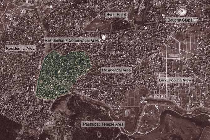
Planning for affordable housing during densification in Kathmandu

Kathmandu faces serious urban planning and
housing challenges. Most development is
occurring beyond the legal limits of zoning bylaws
and building regulations in response to housing
shortages. As settlements densify haphazardly,
affordable housing options are increasing, but living
conditions, services and crowding are worsening.
The potential consequences for low-income
residents are disastrous given the danger of an
imminent earthquake. This paper examines four
types of settlements in Kathmandu to understand
the impacts of densification. It then presents
conceptual reimaginings of these settlements to
apply the lessons for planning affordable housing
in densifying settlements without compromising
unduly on safety and liveability.

Contents
                                                         4 Case studies                                        14
                                                         4.1   Naradevi: Traditional settlement                14
                                                         4.2   Sankhamul and Bansighat: Informal settlements   22
Executive summary                                  5
                                                         4.3   Khusibu: Land-pooling project                   29
                                                         4.4   Chabahil                                        37
1 Introduction                                     7
                                                         5 Conclusions                                         45
2 Transformation of Kathmandu                      8
                                                         5.1 General conclusions and recommendations     45
2.1   History of planning practices in Kathmandu    9
                                                         5.2 Conclusions and recommendations for the four
2.2   Current trends in residential development     9
                                                             case studies                                48
2.3   Rental housing in Kathmandu                  10
2.4   Kathmandu: An urban density study            11   References50

3 Methodology                                      12   Appendix 1                                            51
3.1   Site selection                               12
                                                         Appendix 2: Questionnaire                             67
3.2   Preparation of questionnaire                 12
3.3   Sampling method                              12   Appendix 3: List of Survey Team Members               71
3.4   Field observations                           13
                                                         Appendix 4                                            72
3.5   Data handling                                13
3.6   Data analysis                                13   Related reading                                       74
3.7   Hypothetical replanning exercise             13
                                                         Acronyms75

4     www.iied.org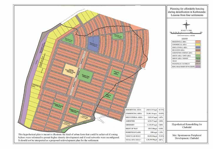
IIED Working paper

Executive summary
Kathmandu is experiencing rapid urban growth, with         Naradevi is an inner-city traditional settlement that
its population nearly doubling in the past decade.         is densifying outside of official rules and regulations
This trend has been accompanied by densification           through the addition of storeys to existing structures; the
in inner-city traditional settlements and in newer         construction of new, taller buildings; and the subdivision
peripheral settlements facing urban growth and             of jointly owned properties. Densities are currently as
expansion pressures.                                       high as 2,112 people per hectare. The original owners
                                                           who can afford automobiles have begun to migrate to
However, most urban growth and densification are
                                                           suburban areas where vehicular accessibility is better.
being accommodated haphazardly in the absence
                                                           This has made the area more affordable to lower-income
of appropriate and enforceable zoning bylaws and
                                                           households and renters; however, living conditions and
building regulations. In practice, land owners and private
                                                           crowding have worsened, particularly in rental spaces.
developers often build beyond legal limits in response
                                                           These conditions have also intensified the settlement’s
to housing shortages, particularly among low-income
                                                           existing vulnerability to earthquake and fire risks.
renters. Consequently, informal rental markets have
grown, whilst living conditions, service provision and     The hypothetical replanning exercise for Naradevi
crowding have worsened.                                    explored four approaches. The least exclusionary
                                                           approach would involve protecting the area’s
Haphazard densification has potentially disastrous
                                                           historically and culturally significant courtyard systems.
consequences for Kathmandu given the danger of
                                                           It would also examine options for promoting fire
an imminent earthquake. This applies especially to
                                                           safety, earthquake-resistant measures and heritage
low-income households living in inadequate housing.
                                                           conservation, without imposing prohibitive costs for land
A number of actions can be taken to avoid these
                                                           owners or driving up rents for low-income groups.
consequences by planning and managing urban growth
more effectively and equitably. These actions must be      Sankhamul and Bansighat are informal settlements
grounded in an understanding of local realities and the    housing some of the poorest residents unable to afford
reasons formal regulations have been so ineffectual.       rental spaces in other parts of the city. Because these
                                                           settlements are located along rivers, they are vulnerable
To develop this understanding, this study has
                                                           to flooding and erosion. They are also under constant
three objectives:
                                                           threat of eviction due to insecure tenure. Despite these
a) To better understand how different types of             risks, Sankhamul and Bansighat offer residents access
     settlements in Kathmandu have developed and           to employment opportunities, basic services and public
     densified over time                                   facilities in central areas they might not otherwise be
                                                           able to access.
b) To better understand how these development
     processes have impacted on urban form and on          In Bansighat, the hypothetical replanning exercise
     social, economic and environmental conditions, and explored relocation and resettlement options due
                                                           to the settlement’s location in a ten-year floodplain.
c) To identify and apply the lessons that these
                                                           However, such options would need to be determined in
     settlements present for planning and developing
                                                           partnership with the community to ensure that its needs,
     affordable housing in densifying settlements.
                                                           priorities and affordability requirements, particularly
To provide a way forward, hypothetical replanning          among the poorest renters, are considered.
exercises have been undertaken for each settlement
                                                           In Sankhamul, the hypothetical replanning exercise
to illustrate how these lessons, applied retrospectively,
                                                           explored on-site redevelopment options. High land
could have been translated into planning and design.
                                                           values meant that houses on plots as small as 30m2
The four types of settlements and their hypothetical
                                                           would be unaffordable for low-income households.
redesigns are outlined below.
                                                           Thus, higher-density two-storey walk-up apartments

                                                                                                       www.iied.org   5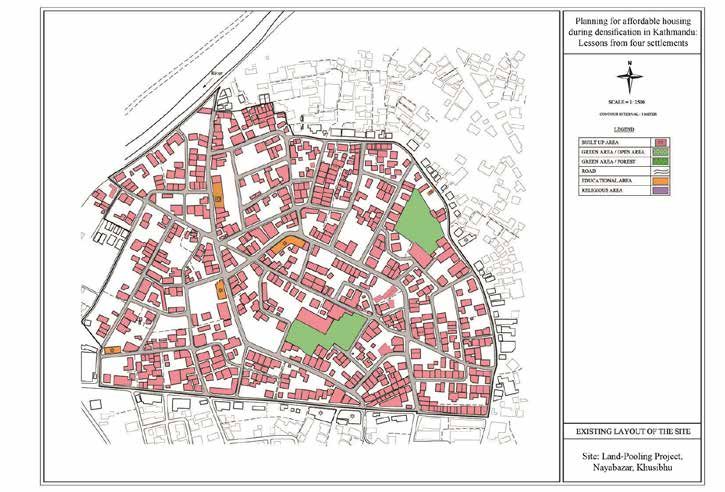
Planning for affordable housing during densification in Kathmandu

were explored to reduce the cost of land and public           The replanning exercise also examined designs
infrastructure provision. The construction of individual      that would support Chabahil’s development into a
houses, which are cheaper to build than apartments            compact, mixed-use, walkable and more functional
(in terms of construction, but not land cost), was            settlement. Also considered was the need to develop
also explored as an alternative, but further study is         more appropriate bylaws and regulations to guide
required to assess both of their social, economic and         this process whilst promoting rental markets and
environmental implications. Ultimately, these options         risk reduction.
should be seen as a response to environmental and

                                                              Key lessons and conclusions
eviction risks and not as a replicable contribution
to addressing the affordable housing shortage in
Kathmandu. Addressing this shortage will require a
                                                              The lessons identified across the five settlements
broader housing strategy that is capable of reaching
                                                              reveal a common tension between enforcement and
the poorest renters. These renters would likely not be
                                                              affordability. There is a clear need to ensure that bylaws
able to afford apartments or individual houses without
                                                              and regulations are adopted by land owners and private
significant public subsidies, which are not guaranteed.
                                                              developers accustomed to evading regulations, and
Khusibu is situated on the periphery of the city and          affordable to lower-income groups accustomed to
was historically protected for agricultural purposes. In      living informally. If this tension is not addressed, it is
1995, the government initiated a land-pooling project         unlikely that existing bylaws and regulations (let alone
to readjust irregularly shaped agricultural land so that it   new bylaws and regulations supporting, for example,
could be redeveloped for residential uses.                    earthquake safety) would be followed.
Over time, Khusibu has evolved into a mixed-use           One potential action area for local authorities would
settlement, reflecting broader socioeconomic dynamics     be to partner with a local NGO, such as the Lumani
in Kathmandu. The area also provides affordable           Support Group for Shelter, that has experience working
housing for renters who work in the city centre. As in    with land owners, private developers and low-income
other parts of Kathmandu, most housing growth has         groups. The purpose would be to establish a platform
been accommodated by new builds and incremental           where discussions around how a more appropriate and
additions violating bylaws and regulations. With          enforceable regulatory framework could be achieved.
densification, other problems involving road congestion,  This platform could also serve as a basis for discussing
                                                          how the potential lessons learnt from land-pooling
infrastructure deficiencies, pollution, and earthquake risk
are emerging.                                             projects could be shared and applied more widely, and
                                                          how appropriate earthquake-resistant measures could
The hypothetical replanning exercise explored alternative
                                                          be incorporated into a regulatory framework that is more
spatial reconfigurations involving gridiron layouts
                                                          likely to be followed.
and traditional courtyards to address some of these
problems. New building plans were also devised to         Ultimately, the development of a more appropriate and
illustrate the potential to accommodate high densities    enforceable regulatory framework (including one that
within smaller plots without compromising unduly          increases safety and reduces risk) will depend largely
on liveability and safety. Given that most bylaws are     on whether the tension between enforcement and
violated, land-pooling projects were also highlighted     affordability can be reconciled. If it can, the planning
as opportunities to test deviations from current bylaws   system will have a real chance of addressing the
and to discuss their impacts and implications for         affordable housing shortage as the city continues to
future developments.                                      grow and densify.
Chabahil is a spontaneously developing settlement
on farmland located outside the old city. The area is
home to a diverse population living in various housing
types, ranging from single-family bungalows to more
compact rental spaces. Although the settlement remains
predominantly low-rise, it is beginning to densify. This
presents an important opportunity for local authorities to
guide the process. The hypothetical replanning exercise
emphasises the opportunity to learn from potential
experiments conducted in land-pooling projects.

6   www.iied.org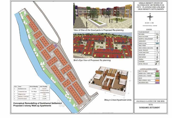
1
                                                                                            IIED Working paper

Introduction
This study seeks to understand how planning can better    This study is comprised of five sections. Section 2
respond to Kathmandu’s affordable housing shortage        examines the transformation of Kathmandu, with a
as the city grows and densifies. To develop this          focus on urban growth and expansion trends. Section 3
understanding, the paper examines four distinct types     outlines the methodologies used by the study. Section 4
of settlements that represent different ways in which     examines each type of settlement, with a focus on urban
growth and densification are being accommodated           growth and densification trends, lessons learnt, and the
in Kathmandu. It also identifies the lessons these        hypothetical replans. Section 5 concludes by discussing
settlements present for planning affordable housing in    the key issues and lessons that need to be considered
densifying settlements and applies them to hypothetical   when planning and developing affordable housing
replanning exercises for each type of settlement. These   during densification in Kathmandu.
replanning exercises are intended to illustrate how
affordable housing could be planned and designed,
still allowing organic development and without
compromising on safety and liveability in Kathmandu.
They also indicate the regulatory reforms that would be
required to achieve this.

                                                                                                   www.iied.org   7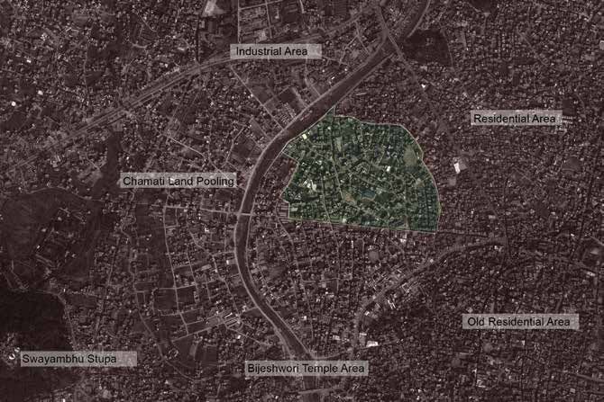
2
Planning for affordable housing during densification in Kathmandu

Transformation of
Kathmandu
The Kathmandu Valley, historically a lake, has a recorded   grew by 61 per cent in the last decade. The city of
history of settlements since the 2nd century AD,            Kathmandu has experienced mounting population
after the lake was drained by the mythological figure       growth at a rate of 4.8 per cent from 1991 to 2001
Manjushree. Covering an area of 654.7 km2 and lying         and 4.1 per cent from 2001 to 2011. The Kathmandu
in the Bagmati River watershed, the valley is gifted with   Valley had an average growth rate of 4.63 per cent
rich soil and a temperate climate, which has attracted      in 2001–2011, compared to the national average of
migrants to settle in this valley ever since. Over time,    3.43 per cent.
with numerous ruling dynasties, it has undergone
                                                            The increase in population also points towards an
various social, political and physical transformations. A
                                                            increase in density.In 2001 the average density of
marked change was witnessed in 1768, when the valley
                                                            Kathmandu City was 136 people per hectare (ppha),
was conquered by the Shah dynasty, which declared
                                                            which increased to 197 ppha in 2011. The dense
Kathmandu the capital of Nepal. After much-awaited
                                                            core area of the city has a ward density of up to 1,181
democratisation in the 1950s, the valley underwent
                                                            ppha. Population growth and densification have also
drastic transformation from agricultural to urban due to
                                                            been marked by the enlargement of the built-up area
the influx of migration and the introduction of vehicles
                                                            manifested by urban sprawl. This has been especially
(Haack and Rafter, 2006).
                                                            evident in the rapidly urbanising VDCs around the
At present, the valley is administratively divided into     valley, whose population growth rates are as high as 14
five municipalities and 94 rapidly urbanising Village       per cent per year (Central Bureau of Statistics, 2002
Development Committees (VDCs), of which Kathmandu           & 2012).
Metropolitan City is the most populated. Kathmandu,
                                                          Urban sprawl has been the major driver of land-use
once a magnificent city with a history visible in its
                                                          change in Kathmandu, where agricultural land is
architecture, has in the last half-century turned into a
                                                          rapidly being converted into built-up areas as a result
sea of people housed in clustered concrete structures.
                                                          of haphazard development. The built-up area in the
It has attracted people from all over the country due
                                                          municipalities grew from 38km2 to 999km2 between
to centralised development, as the valley serves as
                                                          1990 and 2012, an almost threefold increase. The
the economic and administrative capital of the nation.
                                                          built-up coverage has changed from 5 per cent to 16
Migration in search of employment opportunity and
                                                          per cent, while agricultural land has decreased from 58
high-end services, coupled with the insurgency period
                                                          per cent to 47 per cent. The areas of mixed residential
between 1996 and 2006, has resulted in a rapid
                                                          and commercial land have increased six fold and the
population influx into the city and the valley.
                                                          residential land four fold (Genesis Consultancy, 2013).
Rural to urban migration together with natural population This growth is clearly visible in the valley’s peripheral
growth is doubling the population of Kathmandu at a       areas, with significant development extending up into
rapid pace. According to the 2011 National Population     the hills.
and Housing Census, the population of Kathmandu

8   www.iied.org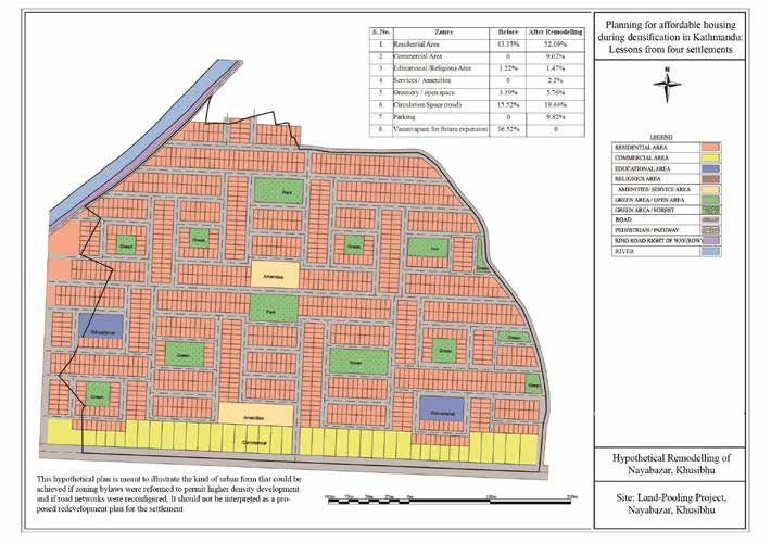
IIED Working paper

2.1 History of planning                                      and looking forward to 2020. The intention was to
                                                             support a holistic approach to urban development,
practices in Kathmandu                                       with efficient integration of land-use and transportation
                                                             planning, conservation of agriculture and public land
With rapid demographic, spatial and social                   through the demarcation of a city growth boundary, as
transformations, physical development of the                 well as adequate infrastructure facilities supporting the
Kathmandu Valley has also been approached with               increased carrying capacity of the valley.
various policies and plans, as an attempt to address
                                                             Though many planning documents have been prepared,
growing urban issues and to guide urban growth.
                                                             they have not achieved anything like their ambitions
In many cases, the intention has been to plan the
                                                             and have had very few impacts. Most of the documents
Kathmandu Valley in an integrated way, rather than
                                                             have stressed the preservation of agricultural land
as a series of individual municipalities. Many planning
                                                             and ecology of the Kathmandu Valley, due to its
documents have been prepared. The Physical
                                                             fragile geological conditions, but these plans have
Development Plan of the Kathmandu Valley, 1969 was
                                                             existed mainly on paper. Major impediments to plan
one of the initial attempts to plan the development of
                                                             implementation have included: lack of synchronisation
the valley. It sought to preserve the valley’s environment
                                                             between projects and plans; lack of coherence between
and rich agricultural land by guiding development to the
                                                             building regulation and land-use planning; and lack of a
western and south-western areas, thereby reducing
                                                             strong legal basis, political will and institutional capacity
population pressures in the central and eastern regions.
                                                             for plan implementation.
Another significant planning document, the Kathmandu

                                                             2.2 Current trends in
Valley Physical Development Plan, 1972, was formulated
to respond to the geographical structure of the valley.

                                                             residential development
It proposed development in the plains (tar) and the
preservation of wetlands (dol) for agriculture. It was
followed by the Land-use Plan of Kathmandu Valley,
                                                             With changing urban form and growth in residential
1976, which introduced extensive land-use zoning
                                                             units, a number of identifiable housing trends have
for the valley together with building regulations. This
                                                             emerged in the valley. They are:
divided the valley into three categories: the inner
core, its adjacent area and the sparse new settlement        • Class-based gated communities and group housing,
area. One of the significant outputs of the document           including high-rise apartments targeted to upper-
was the establishment of the Kathmandu Valley Town             middle and higher-income groups
Development Committee, which still exists in the form of
                                                             • The rapid decay of the historic core area, with an influx
the Kathmandu Valley Development Authority.
                                                               of low-income migrant renters and the relocation of
The Urban Development and Conservation Scheme,                 natives to peripheral/suburban areas
1988, was launched under the leadership of the
                                                             • Urban sprawl and rapid unplanned development of
Ministry of Housing and Physical Planning, which
                                                               peripheral/suburban areas, including an increase in
introduced land pooling and land development
                                                               mixed residential units
programmes in the valley. The Kathmandu Valley Urban
Development Plans and Programmes, 1991, stressed             • Initiation of land pooling projects in some areas to
the densification of the Kathmandu and Lalitpur                adjust the configuration of land and provides services,
municipalities, with development of an inner ring road         and
to preserve agricultural land and reduce the impacts of
                                                             • The undocumented rise in squatter settlement along
urban sprawl. The Environment Plan and Management
                                                               the river banks and public land, due to migration of the
of Kathmandu Valley, 1999, had a similar intent, and
                                                               rural poor in search of a better life.
envisioned Kathmandu as an eco-town. It proposed to
redefine Kathmandu’s physical boundaries, conserve           These development trends reflect failing land-use
traditional settlement, and upgrade and extend the road      control and building regulations, declining living
and sewerage network.                                        conditions among particular segments of the urban
                                                             poor, emerging segregated class-based settlements,
The latest significant planning document, the Long Term
                                                             and rising demand for rental housing to accommodate
Development and Conservation Plan of Kathmandu
                                                             the growing migrant population.
Valley, 2000, considered the regional context of the
Kathmandu Valley, treating it as a development node

                                                                                                          www.iied.org   9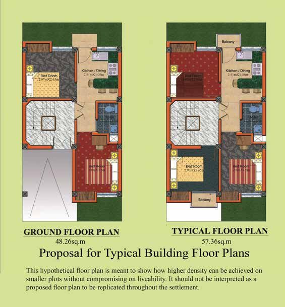
Planning for affordable housing during densification in Kathmandu

2.3 Rental housing in                                                                     city (UN-Habitat, 2010). More than 48 per cent of
                                                                                          the urban population is renting space from individual
Kathmandu                                                                                 homeowners, who often live in the same building. Much
                                                                                          of this demand for rental units is being met by informal
The rapid growth in population, coupled with physical                                     markets, which provide affordable housing options to
constraints on expansion posed by the Kathmandu                                           low-income residents willing to accept overcrowded
Valley’s natural boundaries, explain the unprecedented                                    living conditions and inadequate basic amenities, light
rises in land and housing prices. Rising prices have                                      and ventilation. These conditions create unhealthy
been further augmented by the lack of an effective                                        living environments, particularly where overcrowding is
land information system and transparent land market.                                      combined with inadequate water and sanitation.
A distorted land and housing market has emerged,
                                                                                          The need for rental housing units is clearly visible in the
controlled by a land mafia, brokers and speculators
                                                                                          Kathmandu Valley, where the proportion of households
more concerned with future land prices than with
                                                                                          living in rental units significantly increased from 33 per
current land uses.
                                                                                          cent in 2003 to 48.5 per cent in 2011 (Central Bureau
The city’s housing prices have outpaced the economic                                      of Statistics, 2012). With almost half of the population
capacity of all but the wealthiest in Kathmandu. Though                                   living in rented space, it is high time for Kathmandu to
the National Shelter Policy 2012 affirms ‘shelter for all’                                incorporate the rental sector into its planning efforts.
as its goal, the National Shelter Plan 2070/711 indicates
                                                                                          There is also a clear need to reassess zoning
that this goal is far-fetched, as the projected number of
                                                                                          regulations and other land-use controls. For example,
housing units required in urban areas is 1,300,000, with
                                                                                          limitations to floor area ratios (FAR2) currently restrict
about 900,000 new units required to be constructed
                                                                                          the amount of floor space that can be legally developed,
by 2023. However, UN-Habitat (2010) has projected
                                                                                          thereby exerting downward pressures on housing supply
housing unit production from 2011 to 2021 to be
                                                                                          and upward pressures on housing prices in formal
35,039 annually. Based on this UN-Habitat study, for
                                                                                          markets. The unreasonably strict regulatory framework
a family to build a minimum standard house of 54m2,
                                                                                          often ends up being ignored by private developers and
it needs an average monthly income of NPR 60,471
                                                                                          informal settlers, contributing to the formation of informal
(US$610) to afford a loan that is 40 per cent of the
                                                                                          markets. If formal rules and regulations were strictly
total income. This means “more than 75% of the urban
                                                                                          enforced, then a large share of Kathmandu’s population
population does not have sufficient income to afford the
                                                                                          living in illegal non-conforming structures,3 including
minimum standard 50 m2 self constructed house on 80
                                                                                          informal settlements, would be forced to move out of
m2 plot in the outskirts of a city and 95 percent cannot
                                                                                          their homes, exacerbating the housing scarcity.
afford to purchase a readily built property”. As a result,
the lack of affordable and secure housing for the urban                                   Recent studies in Asian cities, including Karachi,
poor has become one of the most problematic planning                                      Pakistan (Hasan et al. 2010) and Bangkok, Thailand
issues for Kathmandu. Neither the government nor the                                      (Usavagovitwong et al. 2013), show how density
private development sector has formulated appropriate                                     can be used as a tool for planning and developing
housing options for Kathmandu’s poorest citizens.                                         affordable housing, as the construction of additional
                                                                                          units at smaller sizes can reduce the cost of land and
Public housing is non-existent mainly because of the
                                                                                          increase the efficiency of providing basic infrastructure
excessive cost of land, and owner-occupiers are in
                                                                                          and services. This study therefore aims to explore
the minority. Renting at least one or two rooms is
                                                                                          how density can be used as a tool for planning and
affordable for the vast majority of the population (90
                                                                                          developing affordable housing in Kathmandu.
per cent), while only 40 per cent can afford to rent a
basic four-bedroom apartment in the outskirts of the

1
    This refers to the year 2013–2014 in the internationally conventional Gregorian calendar.
2
    FAR refers to the ratio of a building’s total floor area to the size of the plot upon which it is constructed.
3
 Illegal non-conforming structures have been developed or expanded beyond the legal limits of the prevailing zoning bylaw. In contrast, legal non-conforming
structures were developed or expanded before the current zoning bylaw made the development or expansion illegal.

10        www.iied.org
IIED Working paper
2.4 Kathmandu: An urban 1. The densification of traditional settlements,
which currently house a significant proportion of
density study Kathmandu’s population. However, given current
density levels, the scope for continued development
This study has three main objectives: in this form is limited. The settlement examined
is Naradevi.
a) To better understand how different types of
settlements in Kathmandu have developed, densified 2. The development of informal settlements on marginal
and consolidated over time land. Informal settlements currently house 3–4 per
cent of Kathmandu’s population, but a larger share
b) To better understand how these development
of the city’s low-income residents. The settlements
processes have impacted on urban form and on
examined are Sankhamul and Bansighat.
social, economic and environmental conditions, and
3. Land-pooling and housing projects in peripheral
c) To identify and apply the lessons that these
areas, which are an increasingly important housing
settlements present for planning and developing
form and which also accommodates low-income
affordable housing at high density.
tenants. The settlement examined is Khusibu.
To achieve these objectives, this study examines four
4. The spontaneous and incremental conversion of
distinct types of settlements that represent current
farmland into housing, which currently accounts for a
development and expansion trends in Kathmandu.
large and growing share of Kathmandu’s population.
It also identifies lessons and recommendations for
The settlement examined is Chabahil.
planning and developing affordable housing at high
density in these and other settlements in the city. As a The conditions of these sites are compared in
hypothetical exercise, a series of hypothetical redesigns Appendix 1.
are presented to illustrate what these settlements could
possibly look like. The four forms of settlements are:
www.iied.org 113
Planning for affordable housing during densification in Kathmandu
Methodology
3.1 Site selection 3.3 Sampling method
A study site within each of the four settlement groupings Different teams, each with a team leader, were formed
was demarcated using local roads. Each study site for each of the study sites (Appendix 3). A systematic
encompassed approximately 700 to 950 houses. random sampling method was used to select 100 in
However, due to the relatively small size of the squatter each settlement, such that a consistent interval was
settlements, only 110 and 115 houses in Sankhamul and maintained between selected houses. This interval
Bansighat were included, respectively. varied depending on the morphology of the settlement,
such that, for example, every sixth house was selected
3.2 Preparation of
in Khusibu while every second house was selected in
Sankhamul. Both owner-occupiers and renters were
questionnaire interviewed during the survey for each site. However, the
main purpose of the surveys was to provide a general
socioeconomic picture of the area using the most
In each study site, primary data were collected through
systematic methods possible rather than to necessarily
a questionnaire designed to capture both the physical
achieve a representative sample. It should be noted
and social conditions of the settlement, as perceived by
that since only one respondent from each building
the dwellers (including home owners and renters). The
was selected for the questionnaire in each settlement,
questionnaire was framed in seven sections: household
respondents in buildings with multiple households may
information; social condition; environmental condition;
be under-represented.
housing information; details of renters; opinion regarding
the current neighbourhood; and preference for housing
type in an existing or relocated area. However, due to
people’s reluctance to share financial information, data
on income and willingness to pay could not be obtained
from most interviewees across the four settlements.
Appendix 2 contains the questionnaire.
12 www.iied.orgIIED Working paper
3.4 Field observations 3.6 Data analysis
Surveys were coupled with field observations to Results from the survey were analysed and compared
incorporate a professional analysis of the settlement, to draw conclusions for better planning and more
including a focus on building conditions and the overall appropriate development across the settlements. Data
physical and social environment. Key elements on the from each settlement helped in identifying lessons learnt
observation list were: and in guiding the hypothetical redesigning exercise.
• Current physical environment
• Sociocultural relationships; existence and functions of 3.7 Hypothetical
replanning exercise
community organisations like a Guthi4 and tole-lane
organisation (TLO)5, sports clubs, religious festivals,
schools and health services, and
Hypothetical settlement and house plans were
• Economics of land and housing, job markets and developed for the four settlement groupings based on
transport issues. the lessons and recommendations identified for each.
The results of the redesigning exercise were compared
3.5 Data handling
with the existing situation to show envisioned changes
in, for example, density, land coverage and land-use
patterns. (Appendix 4 presents the results of these
The surveyed houses from each study site were plotted
comparisons.) These exploratory plans are intended
in Google Maps to map the settlement for future
to inspire planning and policy for similar settlements
analysis. EpiData software was used to systematically
as they grow and densify. As reimaginings rather
enter, code and analyse the survey data.
than prescriptions, they are not being proposed as
formal redevelopment plans to be implemented in the
selected settlements.
4
Guthi: traditional caste-based community organisation / group formed for a specific purpose.
5
Tole-lane organisation (TLO): community organisation formed at ward level.
www.iied.org 134
Planning for affordable housing during densification in Kathmandu
Case studies
4.1 Naradevi: Traditional
The Mallas superimposed a grid pattern around the
Kathmandu palace complex. The area grew into a dense,
settlement compact settlement, stratified by caste, with higher-
class groups living closer to the palace and lower-class
populations living towards the area’s outskirts. Similar
4.1.1 Naradevi: Then and now hierarchies were maintained in the streets and open
spaces, with major open spaces and wider streets
The study area comprises a section of the ancient
converging towards the palace square (Figure 1).
traditional settlement in Kathmandu that flourished
during the Malla Dynasty between 1200 and 1768.
Figure 1. Naradevi location map
14 www.iied.orgIIED Working paper
The residential areas were traditionally compact settlements are becoming affordable rental units for
and dense, delimited by the city walls and walkable. low-income families.
Extended families belonging to same caste lived in
However, there are serious issues of proper access,
clustered residential blocks comprised of three- to four-
light, ventilation and toilets in these rental spaces. With
storey buildings surrounding courtyards, facing either
increased density achieved in part through crowding, a
the street or an open court (Figure 2). Mud, brick and
lack of maintenance in old buildings, and inaccessibility
wood were the local materials used in the valley, giving
to emergency vehicles, Naradevi is increasingly
the buildings a vernacular aesthetic. The buildings were
vulnerable to earthquake and fire. In addition, most
for private use while the ground floor opening towards
of the new construction has not followed the height
the street had provisions for shopfronts and other
restriction according to the bylaws, which has also
business activities. The open residential courtyards
increased vulnerabilities. The older buildings have either
were used for communal gatherings, household chores,
been modified through vertical increments by using
playing, and similar uses, and were adequately ventilated
modern materials or have been completely replaced by
and lit due to moderate building height.
new concrete structures). The use of modern materials
The study site is centred on a residential block close to incrementally increase building heights to more
to the city’s major markets and to the main trade route than five storeys has in many instances disrupted the
with Tibet. The reason for investigating urban density traditional aesthetic of the area and undermined the role
in a traditional settlement is to capture the mechanisms of open spaces in maintaining ventilation and sunlight.
used to attain high density in low-rise settlements with
The population density of the Kathmandu Valley has
mixed uses. At present, the traditional morphology of
increased drastically in as little as one decade due to
the settlement is still intact within clusters of residential
immigration from other parts of the country during the
blocks and street grid patterns. However, the area has
insurgency period. It has also become heterogeneous;
undergone significant transformation in its physical form,
once a cluster of households from an extended
composition of dwellers and use of buildings. With
family belonging to the same caste, the area is now
native families preferring to live in the suburbs, these
Figure 2. Courtyards in contemporary Naradevi
www.iied.org 15Planning for affordable housing during densification in Kathmandu
home to a mixture of people from different castes, Walking through the streets at the present time is still a
speaking different languages, and holding various privilege as one can capture the ambience of traditional
economic statuses. morphology with deep-rooted planning and building
philosophies. However, as noted above, the picturesque
A team of five conducted surveys of a total of 100
quality of the streetscape has undergone visible
households in the study site. The study site was
changes as the homogeneity of buildings is disrupted
bounded between the junction of Bhedashing and
by modern structures. Today, streets are narrower and
Bangemudha on the Y-axis (north–south) and extending
courtyards are darker due to increased building height
parallel in the western direction, joining the junction with
(Figure 3). In other instances, pedestrian streets with
Tunche Galli, a street near the famous Naradevi temple.
stone and brick pavement have radically changed into
The boundary of the study area was also defined based
roads for two- and four-wheeler vehicles. This has
on the approximate number of houses within the defined
resulted in conflict between pedestrians and vehicle
boundaries. To estimate the total number of houses
users, accompanied by externalities associated with
within the area, a rectangular space was selected from
pollution and congestion.
the junction of the Naradevi temple to about 39.6m
north and 51.8m east. Every house within the enclosed Mixed uses with shops, medical clinics, small offices
area, which is 1/14th of the total study area, was and compact residential units have infused diversity
counted. As there were 67 houses within the area, the into the settlement. The current density of Naradevi is
total number of houses in the study area was estimated as high as 2,112 people per hectare, which excludes
to be approximately 940. the population renting shops and office spaces but
not residing in the area. According to the survey, 33
Both local owner-occupiers and renters were
per cent of renters prefer to live in the area due to job
interviewed. Based on systematic random sampling,
opportunities and access to local businesses. Also,
the team sought to interview every fifth house along the
proximity to facilities, such as markets, hospitals,
area’s main streets. But as inner courts were irregular
schools, and transportation (often within a 3-minute
in shape, the interviews were based on estimated
walking distance) has added value to the locality.
proximity, so that a consistent distance was maintained
Mixed uses with small shops and street vendors,
while conducting interviews with two houses sharing
religious temples at the street intersections, and narrow
a courtyard.
lanes opening to shared courtyards maintain the
residential scale.
Figure 3. Narrow paths in Naradevi
16 www.iied.orgIIED Working paper
By studying the streetscape, one can identify buildings in 58 per cent of households surveyed play in these
of various types, some traditional, some modern courtyards, which are also actively used during feasts
and some a mixture of both. According to the field and for parking vehicles. Whilst these shared open
observations, 36 per cent of the buildings are new spaces once belonged to extended families of the
concrete structures, which have replaced traditional same caste, they are now shared by owner-occupier
ones. 68 per cent of the buildings have mixed uses, and rental populations of different castes, age groups
for either commercial or rental purposes together with and genders. Though some open courts are less
residences. Also, 20 per cent of traditional houses maintained than others, most are well maintained by
have signs of incremental growth. As the traditional the surrounding community. According to the survey,
compact residences could not cater to the spatial needs 38 per cent of people prefer to live in the area due to
of residents, increasing height or reconstruction has its social environment and 40 per cent still prefer to live
been supported by more than 50 per cent of the total in houses around courtyards in new settlements. The
population. This has not only disturbed the physical value of open courtyards is evident; these have not only
homogeneity, but has obstructed light and ventilation to increased the physical value of the community, but have
the central courtyard, creating a feeling of congestion. also contributed to a collective sense of social tolerance
Therefore, the relationship between open spaces and and inclusivity.
buildings is a major factor determining the aesthetic and
The inner streets within the study site are mostly for
environmental value of the place.
pedestrian use, with access by two-wheelers, while the
Open courtyards within the traditional settlement are main street passing through the area has four-wheeler
still the main socialising areas; one can observe people access. Main doors of the houses opening towards the
washing their clothes, children playing and elderly inner streets have prevented the creation of dark corners
people sunbathing. The study site is comprised of 65 in the narrow alleys. However, these narrow alleys
per cent built-up area, 9 per cent streets and 26 per prevent access of emergency vehicles like fire trucks,
cent open space in the form of courtyards. Children ambulances, etc., which presents a clear threat to safety
Figure 4. Narrow access points under houses in Naradevi
www.iied.org 17Planning for affordable housing during densification in Kathmandu
during times of crisis. In some cases, the streets are 4.1.2 Lessons learnt and way forward
too narrow, obstructing flow of more than one person
Based on the survey and field observations, a number of
at a time. The only access points for many open courts
lessons can be learnt from traditional settlements. The
are narrow passageways underneath houses (Figure 4).
list below summarises these lessons for both enhancing
Earthquake risk within the Kathmandu Valley calls into
the physical and social ambience of traditional
question whether these streets and passageways can
settlements and for developing new settlements in
be used as evacuation routes or rather are likely to trap
the future.
people on their way out. Also, frequent maintenance of
sewerage and water supply lines block the way, creating • As the housing preferences of higher-income families
a nuisance for commuters. Surprisingly, 39 per cent and shift towards suburban areas, traditional settlements
37 per cent of those interviewed rated road access as are becoming affordable to growing numbers of lower-
good and moderate, respectively, even in the absence income families and renters.
of direct road access. Along the main outer streets,
• Increased density (achieved in part through crowding),
pedestrian and vehicular movement is dense, with
combined with inadequate access, light, ventilation
shops opening directly onto the street and with sporadic
and sanitation, is a growing concern in rental
vendors obstructing traffic flow and creating conflicts
spaces. The need to improve living conditions must
between people and vehicles.
be balanced against the need to ensure that rental
According to the survey, 50 per cent of respondents spaces remain affordable to lower-income groups.
think their houses are not earthquake-safe and 12 per
• Crowding combined with a lack of maintenance in
cent do not know about the condition of their houses,
older buildings and limited accessibility to emergency
which is indicative of low levels of perceived safety
vehicles has increased risk to earthquake and fire in
in these areas. Field inspection showed direct risks
traditional settlements. Risk reduction measures (eg
from the imminent threat of an earthquake in the form
integrating earthquake-resistant technologies into
of narrow streets, unauthorised incremental growth,
building codes and standards) are clearly required.
narrow access to courtyards from underneath houses
But the measures must be made enforceable in a
and degrading traditional houses (40 per cent of all the
setting where private developers are accustomed to
buildings were assessed to be in moderate condition
evading regulations, and the costs and subsequent
and 12 per cent in poor condition). Many owners
rent hikes must be affordable to low-income groups.
have moved to the valley’s suburbs, with some renting
deteriorating traditional houses to low-income renters. • Future reforms to regulatory frameworks should
Moreover, land conflicts over ancestral property have led consider what private developers and local residents
some owners to stop using them and allow them to fall (including owners and renters) are willing and able
into disrepair. There are many jointly owned properties to afford. This could be determined through their
that are subdivided and reconstructed. At times, engagement in participatory planning processes led
these subdivisions are too small and left in dilapidated by local authorities with the support of local NGOs.
condition due of the lack of commercial return. These
• Densification can be accommodated in traditional
deteriorating and abandoned buildings, inhabited by
areas where courtyards provide adequate sunlight
renters seeking low rents, are considered a threat to
and ventilation, but only where incremental building
their inhabitants and to people living nearby while also
and new development do not overshadow courtyards
reducing the aesthetic value of the area.
or exceed other basic infrastructure and service
Only 34 per cent of households had members involved capacities. Conversely, arguments for limiting or
in social groups and organisations, showing that the reducing density in crowded and overburdened
traditional Guthi system is dissipating, which may be settlements must not overlook the reality of
due to relocation of the native population. However, new housing scarcity.
groups like youth clubs are emerging, which reflects the
• Courtyards are an important social and cultural
area’s changing social composition. The survey shows
amenity that can be used as a structuring element for
that 38 per cent and 54 per cent of respondents gave
developing new settlements that are dense, liveable
high and moderate ratings, respectively, to the current
and socioculturally appropriate.
social environment.
• Mixed uses offer various economic and social
opportunities as well as access to community
facilities (eg hospitals, schools) and markets within
walking distance.
18 www.iied.orgIIED Working paper
• Incremental housing construction is an important wellbeing of the existing low-income residents
practice among low-income households, as it without causing unaffordable rent increases.
addresses the economic and spatial needs of This would involve new structural regulations for
growing families. To improve incremental construction incremental building. It would also seek to reduce
practices, built environment professionals should seismic and fire vulnerability of the traditional
provide technical assistance to local builders settlements to galvanise affordable solutions.
on issues ranging from building regulations to
fire safety and risk reduction, with the support of 4.1.3 Hypothetical replanning of
local authorities. Naradevi
• Vehicular movement into the mixed-use, compact
The study site lies in the cultural heritage conservation
areas should be limited by preventing through traffic
zone and is designated as a combination of the
to encourage and increase the safety of pedestrians
Preserved Cultural Heritage Sub-Zone, the major
wherever possible.
streets, the mixed old residential sub-zone and the
The study’s results have helped to formulate four residential cluster. Considering the area’s close
approaches for addressing current issues in the proximity to a UNESCO World Heritage Site, its
settlement. Though all four approaches have pros and economic potential to support a tourism-based
cons, they should help to frame discussions on how economy deserves to be exploited. However, among the
other traditional settlements in the Kathmandu Valley four recommendations outlined above, the fourth option
might be addressed by future planning efforts. is the most suitable for addressing the housing needs
of Kathmandu’s low-income majority. It focuses on fire
1. A radical way to create a disaster-resilient settlement
and earthquake safety, height restriction and gradual
is to demolish and redevelop the area through
upgrades while reducing density to acceptable limits,
house/land pooling. However, this would have severe
without undermining the liveability or this already dense
social, economic and environmental impacts. While
area. If tourism development is prioritised in some parts
potentially attracting the rich and middle-class, the
of the area, this would likely lead to the displacement
process would also likely drive away poor renters
of low-income residents. However, if a mixed strategy
and transform parts of the settlement from mixed-use
is deployed, tourism development could provide local
to commercial uses.
employment opportunities, while a more supportive
2. A less radical way to reduce disaster risk in the policy environment for affordable low-income rental
settlement would be to lower density by strictly housing could limit the exclusionary pressures.
enforcing bylaws such that additional floors beyond
To support this option, a number of guidelines have
permissible building heights would be demolished
been developed:
(in this case, those beyond 5 storeys). If these
bylaws were strictly enforced, then the density of the i) Fire safety approach
settlement would be reduced from approximately
Based on the information from the Fire Brigade of
2,133 to 1,805 people per hectare. However, from
Kathmandu Municipality, the minimum length of a
a housing perspective, this approach has clear
water hose is 25 metres. Capacity and sizes of the fire
limitations because it overlooks the housing scarcity
engines also vary, ranging from 400 to 4,000 litres, with
and the need to find alternatives to evictions for
a minimum width of 1.7m.
people living in illegal, non-conforming structures.
This approach thus needs to be weighed against Map 1 demarcates the area accessible within the
other approaches, including those promoting range of a 25m-long water hose, which is thus a
appropriate and affordable building retrofits. relatively safer zone. However, narrow inner streets
and insufficient turning radius prevent a large fire
3. A conservation plan that assesses the heritage value
brigade vehicle of 2.1m or above in width from entering
of the buildings and squares is a possibility. This
the inner streets. So a smaller vehicle of 1.7m width
would provide protection and regulatory guidelines
and 400-litre capacity is the available option, which
for renovation and reconstruction to conserve and
requires a minimum street width of 2.1m. Therefore, in
develop the area as a tourist destination, while
this hypothetical remapping the inner streets have been
minimising the displacement of the local population
divided into three categories: 2.1m+ width, 1.7m to 2.1m
and service providers.
width and less than 1.7m width.
4. A much simpler solution is to protect the communal
courtyards and adapt the bylaws to protect the
www.iied.org 19Planning for affordable housing during densification in Kathmandu
Map 1. Conceptual fire safety plan for Naradevi
The structures obstructing access to the 2,1m+ wide retrofitting, as they are used as escape routes during
streets are identified, which include a small single-storey earthquakes. Map 2 identifies major communal open
shop made of corrugated metal sheeting, a private spaces and underpasses that are likely to be used
shrine, private walls, a raised plinth, an uneven street by local people, who will search for open space for
level, a cow shed, and single houses with access to a evacuation and safe shelter during earthquakes.
wider street and a larger courtyard. These streets give
Based on a study done by Ritsumeikan University, Japan
access to some sections of the inner part of the block,
and the Institute of Engineering, Kathmandu (2012), two
which otherwise would not be accessible by the fire
simple techniques (as shown in Map 2) of strengthening
brigade. However, some major obstructions, like a series
load-bearing buildings have been proposed. These
of interconnected buildings along the inner streets,
are: i) addition of vertical timber posts as an additional
block access to the inner courts, creating hazard zones
structural element along the inner walls at regular
that cannot be accessed by the fire brigade. Therefore,
spacing, connected with horizontal timber beams at
future planning efforts in the area need to allow access
floor level, and ii) addition of horizontal concrete bands
by fire brigade vehicles at a minimum width. Map 1
at lintel and beam levels in each storey, which are
identifies some of the specific areas where future
inserted as a structural element by partially cutting out
attention is required.
the walls and tying the additional concrete bands to the
ii) Earthquake safety approach walls with hooks. Columns are placed at the corner to
support the concrete bands.
In the area, there is an urgent need to properly
assess the structural vulnerability of both old and Similarly, research on strengthening reinforced concrete
new structures during seismic activity. Different types row buildings of four storeys or more and a single bay
of retrofitting measures (eg reconstruction, addition suggests an increase in wall thickness to 9 inches on
of structural elements, reduction of loads, etc) can all floors along the longer span of the building. Also
be explored to improve the earthquake resistance of recommended is replacement of masonry walls by
buildings. For safety, communal open spaces and reinforced concrete shear walls (walls with braced
underpasses need to be given special priority while panels to resist horizontal loads) in the traverse direction
20 www.iied.orgYou can also read