St. Clair National Wildlife Area Management Plan - PROPOSED - EcoLog
←
→
Page content transcription
If your browser does not render page correctly, please read the page content below
St. Clair
National Wildlife Area
Management Plan

[PROPOSED]
Acknowledgements:
This management plan was prepared by Laurie Maynard of Environment and Climate Change Canada’s
Canadian Wildlife Service (Ontario). Thank you to Shannon Badzinski, Mike Cadman, Barb Campbell, Brigitte
Collins, Lesley Dunn, Christian Friis, John Haggeman, Krista Holmes, Andrea Kettle, Shawn Meyer, Dave
Moore, Tania Morais, Nancy Patterson, Jeff Robinson, Christopher Sharp, Barbara Slezak and Chip Weseloh
of the Canadian Wildlife Service (Ontario); Gerry Brunet of Environment and Climate Change Canada’s
Wildlife Enforcement Directorate (Ontario); Andrea McCormack of the Canadian Wildlife Service (NCR); Jason
Barnucz and Shawn Staton of Fisheries and Oceans Canada; Allen Woodliffe of the Ontario Ministry of
Natural Resources and Forestry, and Clint Jacobs of the Walpole Island First Nation, for their expert input into
the plan and review of earlier drafts. We also wish to thank Marie-Claude Archambault, Andrew Noad, Corey
Nugent and Paul Watton of the Canadian Wildlife Service (Ontario) for preparation of maps and figures.

The 1982 Management Plan: St. Clair National Wildlife Area, prepared by Gerald McKeating, Duncan Gow,
and Paul Madore of the Canadian Wildlife Service (Ontario) and the 1988 Draft Management Plan: Bear Creek
Unit of the St. Clair National Wildlife Area, prepared by Jeff Robinson (Canadian Wildlife Service (Ontario))
provided the groundwork for this update.

Copies of this plan are available at the following addresses:
Environment and Climate Change Canada
Public Inquiries Centre
 th
7 Floor, Fontaine Building
200 Sacré-Coeur Boulevard
Gatineau QC K1A 0H3
Telephone: 819-997-2800
Toll Free: 1-800-668-6767 (in Canada only)
Email: ec.enviroinfo.ec@canada.ca

Environment and Climate Change Canada – Canadian Wildlife Service (Ontario Region)
4905 Dufferin Street
Toronto ON M3H 5T4

Environment and Climate Change Canada Protected Areas website:
www.ec.gc.ca/ap-pa

ISBN: 978-1-100-25170-7
Cat. No.: CW66-503/2014E-PDF

How to cite this document:
Environment and Climate Change Canada. 2016. St. Clair National Wildlife Area Management Plan
(Proposed). Environment and Climate Change Canada, Canadian Wildlife Service, Ontario Region, 76 p.

Unless otherwise specified, you may not reproduce materials in this publication, in whole or in part, for the
purposes of commercial redistribution without prior written permission from Environment and Climate Change
Canada's copyright administrator. To obtain permission to reproduce Government of Canada materials for
commercial purposes, apply for Crown copyright clearance by contacting:

Environment and Climate Change Canada
Public Inquiries Centre
 th
7 Floor, Fontaine Building
200 Sacré-Coeur Boulevard
Gatineau QC K1A 0H3
Telephone: 819-997-2800
Toll Free: 1-800-668-6767 (in Canada only)
Email: ec.enviroinfo.ec@canada.ca

© Her Majesty the Queen in Right of Canada, represented by the Minister of the Environment and Climate
Change, 2016
Aussi disponible en français
About Environment and Climate Change Canada’s protected
areas and management plans
What are Environment and Climate Change Canada’s protected areas?

       Environment and Climate Change Canada establishes marine and terrestrial national wildlife
areas for the purposes of conservation, research and interpretation. National wildlife areas are
established to protect migratory birds, species at risk, and other wildlife and their habitats. National
wildlife areas are established under the authority of the Canada Wildlife Act and are, first and
foremost, places for wildlife. Migratory bird sanctuaries are established under the authority of the
Migratory Birds Convention Act, 1994 and provide a refuge for migratory birds in the marine and
terrestrial environment.

What is the size of the Environment and Climate Change Canada’s protected areas network?

       The current protected areas network consists of 54 national wildlife areas and 92 migratory
bird sanctuaries comprising more than 12 million hectares across Canada.

What is a management plan?

       A management plan provides the framework in which management decisions are made.
They are intended to be used by Environment and Climate Change Canada staff to guide decision
making, notably with respect to permitting. Management is undertaken in order to maintain the
ecological integrity of the protected area and to maintain the attributes for which the protected area
was established. Environment and Climate Change Canada prepares a management plan for each
protected area in consultation with First Nations and other stakeholders.

       A management plan specifies activities that are allowed and identifies other activities that
may be undertaken under the authority of a permit. It may also describe the necessary
improvements needed in the habitat, and specify where and when these improvements should be
made. A management plan identifies Aboriginal rights and allowable practices specified under land
claims agreements. Further, measures carried out for the conservation of wildlife must not be
inconsistent with any law respecting wildlife in the province in which the protected area is situated.

What is protected area management?

       Protected area management includes monitoring wildlife, maintaining and improving wildlife
habitat, periodic inspections, enforcement of regulations, and the maintenance of facilities and

                                                           St. Clair National Wildlife Area Management Plan (Proposed)   i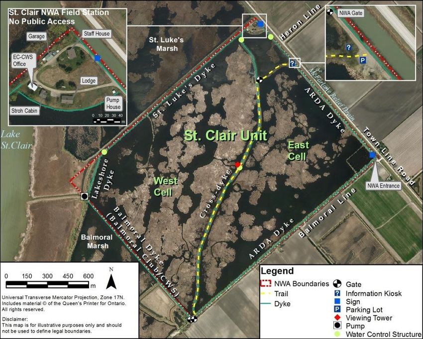
infrastructure. Research is also an important activity in protected areas; hence, Environment and
       Climate Change Canada staff members carry out or coordinate research in some sites.

       The series

                All of the national wildlife areas are to have a management plan. All of these management
       plans are initially reviewed 5 years after the approval of the first plan, and every 10 years thereafter.

       To learn more

                To learn more about Environment and Climate Change Canada’s protected areas, please
       visit our website at www.ec.gc.ca/ap-pa or contact the Canadian Wildlife Service.

ii   St. Clair National Wildlife Area Management Plan (Proposed)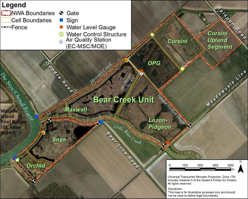
St. Clair National Wildlife Area
       The St. Clair National Wildlife Area (NWA) (St. Clair Unit) was established in 1978 along the
eastern shore of Lake St. Clair to protect wetlands of the St. Clair marshes as essential habitat to
waterfowl and other migratory birds for staging, stopover and feeding. Lake St. Clair and the
adjacent marshes are the most important and extensive staging and feeding areas for migratory
waterfowl in Ontario south of James Bay. In 1988, the NWA was expanded (Bear Creek Unit) to
include additional property on the eastern shore of the Snye channel or Chenal Ecarté, a tributary of
Lake St. Clair.

       The Great Lakes shoreline within Canada’s Mixedwood Plains Ecozone contains some of the
most modified landscapes in Canada, and also some of the most important bird areas in North
America. Prior to European settlement in the 1800s, the Lake St. Clair shoreline was once an
extensive belt of marsh and tallgrass prairie, but as much as 90% of the coastal and inland marshes
have been converted to agriculture and residential development. The protection, management and
connectivity of the remaining habitat, including within the NWA, is essential to maintain wetland and
prairie habitat in the Lake St. Clair region. St. Clair NWA Units are protected areas within this
drastically altered landscape. They provide important spring and fall migratory stop-over locations
along the eastern flyway of North America, and their wetland, meadow and tallgrass prairie habitats
are managed to provide nesting and roosting cover for migratory birds and species at risk. In 1985,
the St. Clair NWA (St. Clair Unit) was designated as a Ramsar Wetland of International Importance,
and in 1998, eastern Lake St. Clair, including the NWA’s St. Clair Unit, was designated by Birdlife
International as a globally significant Important Bird Area.

       The St. Clair NWA is an important migration stopover, breeding site and pre-migration
congregating area for an impressive number and variety of migratory birds: over 220 species of
birds have been observed since 1974, with more than 60 species observed breeding in the NWA,
including waterfowl, waterbirds, landbirds and shorebirds. Peak numbers occur during fall migration
where as many as 8600 waterfowl, including ducks, geese and swans, can congregate at the Lake
St. Clair NWA to rest and feed in the marshes before continuing their migration south. More than 20
waterfowl species have been recorded in the NWA, primarily dabbling ducks and geese, including
Mallards, American Black Ducks, American Wigeons, and migrant and temperate-breeding
(resident) Canada Geese.

       Thirty-five species listed under the federal Species at Risk Act have been reported at the St.
Clair NWA, including 18 birds, 7 reptiles, 1 insect, 4 fishes, 1 mammal and 4 plants. Many species
are at the northern limit of their range in this part of Ontario and are rare or absent elsewhere in
Canada. The NWA provides important habitat for species at risk like the Least Bittern, Swamp Rose-

                                                          St. Clair National Wildlife Area Management Plan (Proposed)   iii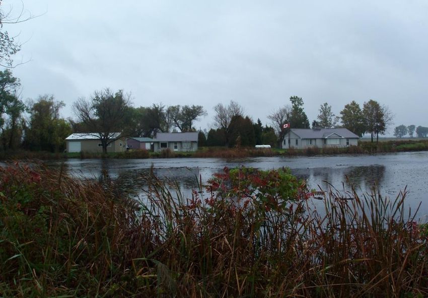
mallow, Northern Map Turtle, and Pugnose Shiner and critical habitat has been identified for some
       of them. Several bird species at risk use the NWA as an area of respite during migration, including
       the Golden-winged Warbler, Eastern Whip-poor-will and Rusty Blackbird. The St. Clair NWA is also
       an important roosting and feeding area for Monarch butterflies during migration. In late summer and
       early fall, several thousand Monarchs can be observed daily in the area as they migrate to their
       wintering grounds to the south.

               Habitats at the St. Clair NWA include wetlands, tallgrass prairie, uplands and farmland,
       totalling up to 351.8 hectares (ha). The predominant habitat within the NWA is cattail marsh. Earthen
       dykes surround marsh compartments, and water levels are controlled within the dyked
       impoundments by a system of water control structures and pumps to replicate the natural rise and
       fall of water levels that triggers a diversity of plant growth. The St. Clair NWA is managed to provide
       optimum habitat diversity, quality staging and nesting habitat for waterfowl and marshbirds, and
       conservation and restoration of wetland and prairie habitats. A variety of wildlife and habitat
       management techniques are employed. Priority management actions include manipulation of water
       levels to encourage the growth of a diverse community of wetland vegetation, removal and reduction
       of invasive and non-native plant species, prairie restoration, fur-bearer trapping, and control of
       overabundant wildlife.

               Most of the St. Clair NWA, including the Bear Creek Unit and portions of the St. Clair Unit, is
       closed to the public in order to provide undisturbed staging habitat for migratory waterfowl, with
       exceptions made for research, surveys and monitoring activities authorized by permit under the
       Wildlife Area Regulations of the Canada Wildlife Act. Within the St. Clair Unit, public access for
       interpretation and recreation is limited to day use only where a hiking trail and a wildlife viewing
       tower on the cross-dyke are open to the public year-round, providing opportunities to view large
       numbers of waterfowl during spring and fall migration. Fishing and recreational boating within the St.
       Clair Unit are prohibited. Within the Bear Creek Unit, public access is limited to recreational boating
       and fishing, and to wildlife viewing in the Maxwell and Little Bear Creeks. Overnight camping, open
       fires, hunting and use of motorized off-road vehicles are prohibited at all times.

               This 2016 St. Clair NWA Management Plan is an update of the Management Plan: St. Clair
       National Wildlife Area (McKeating et al. 1982) and the Draft Management Plan: Bear Creek Unit, of
       the St. Clair National Wildlife Area (Robinson 1988), and replaces all previous versions.

               For greater certainty, nothing in this management plan shall be construed so as to abrogate
       or derogate from the protection provided for existing Aboriginal rights or treaty rights of the
       Aboriginal peoples of Canada by the recognition and affirmation of those rights in section 35 of the
       Constitution Act, 1982.

iv   St. Clair National Wildlife Area Management Plan (Proposed)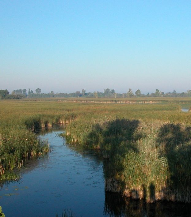
Table of Contents

1         DESCRIPTION OF THE PROTECTED AREA ...................................................................... 1
    1.1      Regional Context ............................................................................................................. 7
    1.2      Historical Background ..................................................................................................... 9
    1.3      Land Ownership ............................................................................................................ 12
    1.4      Facilities and Infrastructure ........................................................................................... 13
2       ECOLOGICAL RESOURCES ............................................................................................. 18
    2.1     Terrestrial and Aquatic Habitats .................................................................................... 18
        2.1.1    Wetlands ................................................................................................................ 18
        2.1.2    Watercourses......................................................................................................... 20
        2.1.3    Tallgrass Prairie ..................................................................................................... 20
        2.1.4    Earthen Dykes and Uplands .................................................................................. 21
    2.2     Wildlife .......................................................................................................................... 21
        2.2.1    Birds ...................................................................................................................... 21
        2.2.2    Mammals ............................................................................................................... 25
        2.2.3    Reptiles and Amphibians ....................................................................................... 26
        2.2.4    Fish ........................................................................................................................ 27
        2.2.5    Invertebrates .......................................................................................................... 28
    2.3     Species at Risk ............................................................................................................. 28
3         MANAGEMENT CHALLENGES AND THREATS ............................................................... 32
    3.1       Water Management, Climate Variability and Projected Climate Change........................ 32
    3.2       Invasive and Non-native Plant Species ......................................................................... 33
    3.3       Overabundant Wildlife ................................................................................................... 34
          3.3.1   Muskrats, Beavers, Groundhogs and Raccoons .................................................... 34
          3.3.2   Mute Swans ........................................................................................................... 34
          3.3.3   Temperate-breeding (resident) Canada Geese ...................................................... 35
          3.3.4   Carp ....................................................................................................................... 35
    3.4       Feral and Domestic Animals and Release of Unwanted Pets and Wildlife ..................... 36
    3.5       Maintenance of Safe Water Supply ............................................................................... 36
    3.6       Wetland Habitat Loss and Fragmentation ...................................................................... 37
    3.7       Other Management Challenges ..................................................................................... 38
          3.7.1   Demand for Public Access and Services ................................................................ 38
          3.7.2   Multi-species Conservation and Species at Risk .................................................... 38
4       GOALS AND OBJECTIVES................................................................................................ 39
    4.1   Vision ............................................................................................................................ 39
    4.2   Goals and Objectives .................................................................................................... 39
    4.3   Evaluation ..................................................................................................................... 44
5       MANAGEMENT APPROACHES ........................................................................................ 45
    5.1     Habitat Protection and Management ............................................................................. 45
        5.1.1    Wetland Habitat Management ................................................................................ 45
        5.1.2    Water Supply and Water Quality Protection ........................................................... 46
        5.1.3    Terrestrial Habitat Management ............................................................................. 47
    5.2     Wildlife Management ..................................................................................................... 48
        5.2.1    Waterfowl and Migratory Birds ............................................................................... 48

                                                                                St. Clair National Wildlife Area Management Plan (Proposed)          v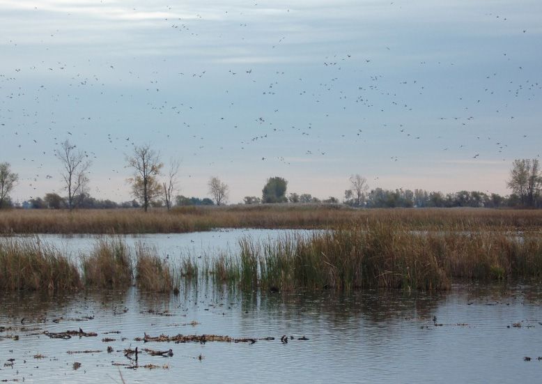
5.2.2    Management of Overabundant Wildlife, and Feral and Domestic Animals ............. 48
            5.3       Species at Risk ............................................................................................................. 49
            5.4       Multi-Agency Land management Partnerships .............................................................. 49
            5.5       Monitoring and Surveys ................................................................................................. 50
            5.6       Research ....................................................................................................................... 51
            5.7       Public Access, Information and Outreach ...................................................................... 52
       6          AUTHORIZATIONS AND PROHIBITIONS ......................................................................... 54
            6.1      Prohibition of Entry ........................................................................................................ 54
            6.2      Authorized Activities ...................................................................................................... 55
            6.3      Authorizations ............................................................................................................... 56
            6.4      Exceptions..................................................................................................................... 57
       7          HEALTH AND SAFETY ...................................................................................................... 58
       8          ENFORCEMENT ................................................................................................................. 60
       9        PLAN IMPLEMENTATION .................................................................................................. 61
            9.1    Management Authority and Mandate ............................................................................. 63
            9.2    Management Plan Review............................................................................................. 63
       10         COLLABORATORS ............................................................................................................ 64
       11         LITERATURE CITED .......................................................................................................... 65
       12         ADDITIONAL INFORMATION SOURCES .......................................................................... 72
       APPENDIX 1: LEGISLATION......................................................................................................... 73
       APPENDIX 2: CANADIAN WILDLIFE SERVICE (ONTARIO) CONDITIONS OF RESEARCH
       REQUESTS .................................................................................................................................... 74
       APPENDIX 3: CONTACTS FOR THE ST. CLAIR NATIONAL WILDLIFE AREA, ONTARIO ........ 75

vi   St. Clair National Wildlife Area Management Plan (Proposed)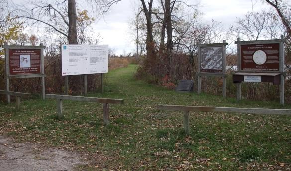
1 DESCRIPTION OF THE PROTECTED AREA
The St. Clair National Wildlife Area (NWA) was established in 1978 and provides
continentally and nationally important habitat for migratory birds, wildlife, and species at risk. The
diversity and number of plant and animal species is high due to its location in one of the
southernmost locations of Canada, and its warmer climate moderated by the nearby Great Lakes.
Several species found on the NWA are at the northern limit of their ranges. Wetlands are the major
habitat features of the NWA with patches of prairie and upland habitat in the drier areas.
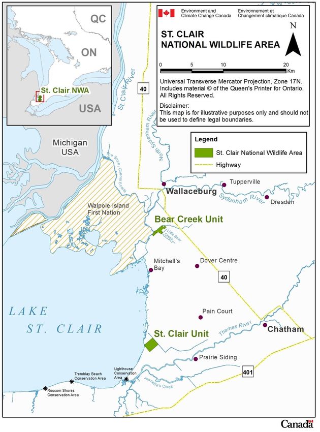
The St. Clair National Wildlife Area (NWA) is comprised of two Units totalling 351.8 hectares
(ha) along the eastern shore of Lake St. Clair in southwestern Ontario (Figure 1). The St. Clair Unit
(242.8 ha) is located 19 km west of Chatham, on the southeast shore of Lake St. Clair (Figure 1).
The Bear Creek Unit (109 ha) is located approximately 20 km north of the St. Clair Unit and 7 km
south of Wallaceburg, where the Little Bear Creek and Maxwell Creek enter the eastern channel of
the St. Clair River known locally as The Snye or Chenal Ecarté (hereafter referred to as the Snye
channel), southeast of the Walpole Island First Nation (Figure 1).
St. Clair Unit
Located on the edge of a clay plain where it meets the eastern shore of Lake St. Clair, the
St. Clair Unit consists of two large dyked wetland impoundments, known as the East and West cells,
a small, undyked open-water marsh (approximately 5 ha) west of the Lakeshore Dyke on Lake St.
Clair and, 3 ha of dry land in the north corner of the property that houses the St. Clair NWA office
and other buildings. A series of former sandy-beach ridges, formed by wave action, run diagonally
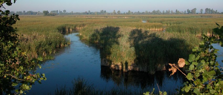
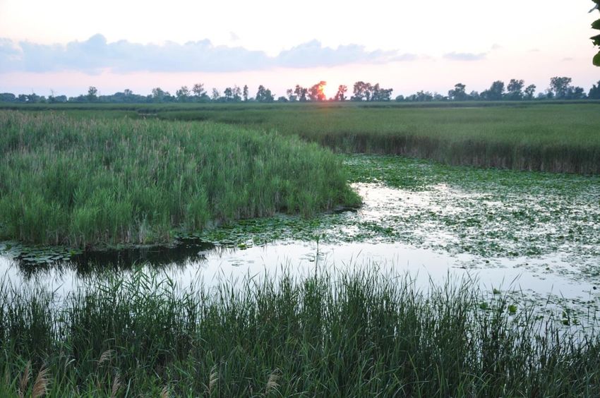
north-south across the Unit (Figure 2). Both cells are predominantly cattail (Typha spp.) marsh with
areas of shallow open water (approximately 1–2 m deep). Water levels are managed within the cells
using a system of water control structures and a pump. A public trail runs along the top of the cross-
dyke that separates the East and West cells (Figure 2).
Land cover adjacent to the St. Clair Unit is primarily privately owned agricultural land (e.g.,
cropland growing vegetables, corn and soybeans) and marshes managed for waterfowl hunting
(Figure 2).
St. Clair National Wildlife Area Management Plan (Proposed) 1Figure 1: Location of the St. Clair National Wildlife Area, Ontario
Source: Environment Canada – Canadian Wildlife Service (Ontario), 2013
2 St. Clair National Wildlife Area Management Plan (Proposed)Figure 2: Aerial view of the St. Clair Unit, St. Clair National Wildlife Area (2006)
Source: Environment Canada, Canadian Wildlife Service – Ontario, 2013
Bear Creek Unit
The Bear Creek Unit is located at the mouth of Little Bear Creek and the mouth of Maxwell
Creek where they enter at the Snye channel of the St. Clair River (Figure 3). The Snye channel is
the easternmost channel of the St. Clair River delta, at the mouth of the St. Clair River where it
enters Lake St. Clair (Figure 1). The Bear Creek Unit is inland from Lake St. Clair and thus is
influenced more by the St. Clair River than by the lake.
The Bear Creek Unit consists of six dyked impoundments known as the Orchid, Snye,
Maxwell, Lozon-Pidgeon,1 OPG (Ontario Power Generation) and Corsini cells, and one upland area
known as the Corsini Upland segment (Figure 3). The cell names are attributed to the previous
landowners (Corsini, Pidgeon), nearby watercourses (the Snye channel, Maxwell), and agencies or
individuals (OPG, Lozon) that have contributed to the conservation of this NWA. The NWA
1
Lozon-Pidgeon is also known as Pigeon Marsh and Pidgeon Marsh.
St. Clair National Wildlife Area Management Plan (Proposed) 3boundary, along the Maxwell and Little Bear Creeks (i.e., adjacent to the Maxwell, OPG, Corsini and
Lozon-Pidgeon cells) extends (approximately 15 m) to the centre line of these creeks. The NWA
boundary extends only to the water’s edge along the Snye channel (i.e., Snye and Orchid cells)
(Figure 3).
Within the Unit, the Orchid cell is predominantly tallgrass prairie, while the Snye channel,
Maxwell, Lozon-Pidgeon and OPG cells, and the western half of the Corsini cell, are predominantly
shallow marsh. The eastern half of the Corsini cell contains primarily old field (former cropland) and
a small area of upland native tallgrass prairie. Water levels are managed within the cells using a
system of pumps and water control structures. Areas outside the dyked impoundments include the
Corsini Upland segment, which consists of cultivated tallgrass prairie, the grassed dykes and banks
along watercourses, the Old Marden Dredge Cut, and a marsh area at the mouth of the Little Bear
Creek (Figure 3). Land cover adjacent to the Bear Creek Unit is primarily privately owned
agricultural land (e.g., cropland growing vegetables, corn and soybeans) and private marshes
managed for waterfowl hunting (Figure 3). The Walpole Island First Nation is situated on the St.
Clair River delta northwest of the Bear Creek Unit, on the west shore of the Snye channel (Figure 3).
Figure 3: Aerial view of Bear Creek Unit, St. Clair National Wildlife Area (2006)
Source: Environment Canada – Canadian Wildlife Service (Ontario), 2013
4 St. Clair National Wildlife Area Management Plan (Proposed)Table 1: St. Clair National Wildlife Area Protected Area Summary Information
Protected Area Designation National Wildlife Area
Province or Territory Ontario
Municipality Municipality of Chatham–Kent
Geographic County (historical) Kent County
Geographic Township (historical) Township of Dover
Latitude and Longitude St. Clair Unit: Bear Creek Unit:
Latitude 42.366334 Latitude 42.533290
Longitude -82.405108 Longitude -82.396169
Size Total 351.8 ha
St. Clair Unit: Bear Creek Unit:
242.8 ha 109.0 ha
Environment and Climate Change Criteria 1(a) The area supports a population of a species or subspecies
Canada Protected Area or a group of species which is concentrated, for any portion of the year.
Designation Criteria Lake St. Clair and adjacent marshes are the most important staging
and feeding areas for migratory waterfowl in Ontario south of James
Bay.
In late fall, tens of thousands of diving ducks are found in rafts on the
lake.
Marshes adjacent to the lake contain tens of thousands of puddle
ducks and geese.
A large proportion of the eastern population of Tundra Swans (Cygnus
columbianus) passes through the region in early spring.
The area is a refuge for several species of waterfowl and marshbirds
in summer and fall during the post-breeding molt.
Monarch butterflies (Danaus plexippus) breed in the NWA (June–
September), and feed and roost in the NWA during migration (late
summer–early fall), when several thousand can be observed daily in
the Lake St. Clair area.
Criteria 3(a) The area is rare or unusual wildlife habitat, of a specific
type in a biogeographic region.
Wetland and tallgrass prairie habitats are rare in southwestern
Ontario; over 90% of pre-European settlement wetlands in this region
have been dyked and drained or converted to other uses, primarily
agriculture.
The diversity and number of plant and animal species is high due to
the moderate climate; several species are at the northern extent of
their North American range.
Significant numbers of species at risk in Canada and/or rare species
in Ontario are found there.
Environment and Climate Change Category A – Species or critical habitat conservation.
Canada Protected Area
Classification System
International Union for Category IV habitat/species management area: Category IV provides a
Conservation of Nature (IUCN) management approach used in areas that have already undergone
Classification substantial modification, necessitating protection of remaining
fragments, with or without intervention.
Order in Council Number St. Clair Unit: Bear Creek Unit:
P.C. 1978-1439 P.C. 1988-829
Directory of Federal Real Property 10656 67558
(DFRP) Number
Gazetted 1978 1988
Additional Designations St. Clair NWA Ramsar Site – Wetland of International Importance (St.
Clair Unit)
Eastern Lake St. Clair – globally significant Important Bird Area
(includes NWA)
St. Clair Marshes Complex – Provincially Significant Wetland
St. Clair National Wildlife Area Management Plan (Proposed) 5(includes NWA)
Lake St. Clair Marshes Ontario Life Science – Area of Natural and
Scientific Interest (includes NWA)
North American Waterfowl Management Plan Lower Great Lakes and
St. Lawrence River Area of Continental Significance (Eastern Habitat
Joint Venture) (includes NWA)
Canada–United States St. Clair River Area of Concern (Bear Creek
Unit)
Faunistic and Floristic Importance Over 220 bird species were observed at the NWA from 1974–2011
and more than 60 of these species have been recorded breeding at
the NWA.
Over 20 species of waterfowl, and fall abundance peaks of 8600
individuals, primarily Mallard, American Black Duck and Canada
Goose (Southern James Bay population) have been recorded at the
NWA
The Lake St. Clair region, which includes the NWA, is an important
staging area for waterfowl, with fall and spring peaks of 150 000 and
60 000 birds, respectively.
A large proportion of the eastern population of Tundra Swans passes
through the NWA in the spring en route to breeding grounds in the
Canadian Arctic and Alaska.
The NWA provides important habitat for both common and rare
species. In addition to birds, 21 mammal species, 15 reptile and
amphibian species, and 27 fish species have been reported.
Key habitats include a large marsh (part of the internationally and
provincially significant Lake St. Clair wetland complex) and a small
remnant patch of tallgrass prairie.
Species at Risk 35 federally listed species (Endangered, Threatened and Special
Concern) under the Species at Risk Act (SARA), including 18 birds, 7
reptiles, 1 insect, 4 fishes, 1 mammal and 4 vascular plants;
40 species designated by the Committee on the Status of Endangered
Wildlife in Canada (COSEWIC) have been recorded at the NWA (i.e.,
5 bird species in addition to SARA-listed species); and
2 additional provincially listed species under the Endangered Species
Act, 2007 (ESA) have been recorded.
Invasive and/or Non-native Species Plants include non-native Phragmites/European Common Reed
(Phragmites australis subsp. australis), Purple Loosestrife (Lythrum
salicaria), Eurasian Watermilfoil (Myriophyllum spicatum), Frog-bit or
European Frog-bit (Hydrocharis morsus-ranae), Curly-leaf Pondweed
(Potamogeton crispus), Water Lettuce (Pistia stratiotes), Flowering
Rush (Butomus umbellatus), Reed Canary Grass (Phalaris
arundinacea), Sow Thistle (Sonchus oleraceus L.), Canada Thistle
(Cirsium arvense), Prickly Lettuce (Lactuca scariola) and White
Mulberry (Morus alba).
Animals include Common Carp (Cyprinus carpio), Round Goby
(Neogobius melanostomus), Mute Swan (Cygnus olor), temperate-
breeding (resident) Canada Goose (Branta canadensis), American
Crow (Corvus brachyrhynchos), Double-crested Cormorant
(Phalacrocorax auritus), and feral domestic cats and dogs.
Management Agency Environment and Climate Change Canada (Canadian Wildlife Service)
Public Access and Use Limited public access is authorized in designated areas for day use only
in the St. Clair Unit, which include a hiking trail and wildlife viewing
tower that are open to the public year-round.
Public access is prohibited in the Bear Creek Unit except for water
access to the Maxwell and Little Bear Creeks for recreational boating
and fishing (no lead sinkers or spears).
Access to other parts of the NWA is restricted, and all other activities
within the NWA require a Canada Wildlife Act permit.
6 St. Clair National Wildlife Area Management Plan (Proposed)1.1 REGIONAL CONTEXT
The St. Clair NWA is within the Municipality of Chatham–Kent (formerly the Township of
Dover, Kent County) along the eastern shore of Lake St. Clair, the smallest lake within the
Laurentian Great Lakes system. Located between the upper and lower Great Lakes, Lake St. Clair
connects Lake Huron to Lake Erie via the St. Clair and Detroit Rivers as part of the Great Lakes
Seaway, and shares international borders between Canada and the United States of America
(Figure 1). Dredging maintains a key shipping channel that extends from the mouth of the St. Clair
River to the Detroit River. The St. Clair River enters Lake St. Clair in the northeast and forms the
large St. Clair delta, the largest freshwater delta in the world (Henson et al. 2010).
Walpole Island First Nation includes most of the St. Clair River delta (Figure 1).The Walpole
Island First Nation is referred to in Ojibwe as “Bkejwanong” (where the waters divide) and consists
of six islands (Walpole, St. Anne, Potawatomi, Squirrel, Bassett and Seaway).
For many years, the St. Clair River has been subject to industrial activity and urban
development along its shores including unregulated discharges from petroleum refineries, chemical
manufacturers, paper mills, electric power plants and runoff from agricultural operations in rural
areas of the watershed (Environment Canada and Ontario Ministry of the Environment 2011). In
1987 the St. Clair River, its delta channels and its immediate drainage basin was designated an
Area of Concern under the Canada – United States Great Lakes Water Quality Agreement. A
coordinated remedial action plan is legislated. The Bear Creek Unit falls within this Area of Concern.
The landscape including and surrounding the St. Clair NWA is locally known as the Chatham
Flats—tabletop flat lands that slope slightly toward Lake St. Clair created during the glacial retreat
where suspended sediments were deposited forming stone-free, flat, clay plains. Chatham Flats is
mainly a marsh habitat with remnant patches of tallgrass prairie. This low-lying plain contains some
of the most fertile soils in southern Ontario. Much of the land is dyked and tile-drained for
agriculture; drains and ditches running beside farmlands end in pumping stations. The black soils,
enriched by the once-broad tallgrass prairies, produce high yields of a variety of vegetables,
including tomatoes, onions, carrots and beets; and of cash crops, including corn, soybeans and
winter wheat. Corn is the principal crop accounting for about 60 percent of the land being farmed
(Jalava et al. 2013).
The region contains some of the largest coastal wetlands in the Great Lakes. Marshes occur
along the Ontario shore of Lake St. Clair, stretching north from the mouth of the Thames River to
Mitchell’s Bay, and the north shore of the lake in the St. Clair delta. Approximately 12,769 ha of
coastal wetlands occur on the Canadian side of the St. Clair delta, with the majority of these
wetlands, approximately 10,360 ha, located on the Walpole Island First Nation (Environment
St. Clair National Wildlife Area Management Plan (Proposed) 7Canada and Ontario Ministry of Natural Resources 2003). Five other wetlands totalling
approximately 2,522 ha are located south of the St. Clair delta along the eastern and southern
shores of Lake St. Clair: Paternoster Club Marsh (3.9 ha), Tremblay Beach Marsh (24 ha), Ruscom
Shores Marsh (29 ha), Thames River Mouth (131 ha) and the St. Clair Marshes Complex (2,335 ha)
(Environment Canada and Ontario Ministry of Natural Resources 2003). The St. Clair NWA (St. Clair
Unit) is part of the St. Clair Marshes Complex, a Provincially Significant Wetland complex
comprising 20 marshes, including, Bradley Marsh, Balmoral Marsh, St. Luke’s Marsh and Big Point
Club (Environment Canada and Ontario Ministry of Natural Resources 2003).
Walpole Island First Nation is known for some of the richest and most diverse wetlands in the
Great Lakes but also includes rare remnant tallgrass prairies. Recreation and tourism is an
important industry in the community and many still support their families by guiding and participating
in hunting, trapping and fishing.
Almost all wetlands along the Canadian Lake St. Clair shoreline, south of the Walpole Island
First Nation, are privately owned and are maintained by private clubs for waterfowl hunting (e.g.,
Bradley Marsh, Balmoral Marsh, St. Luke’s Marsh and Big Point Club). Many of these wetlands are
dyked, and water levels are controlled (EHJV 1998). Where wetlands are not controlled, water level
fluctuations greatly affect the extent and position of wetlands because the topography surrounding
much of the lake and especially in the delta is almost flat. Large changes in wetland area are
especially great between years of high and low water levels (Herdendorf et al. 1986).
Lake St. Clair is popular for boating and fishing in the summer months, waterfowl hunting in
the fall, and bird watching in the spring and fall. In the winter, snowmobiling and ice fishing take
place on the lake. Associated tourism benefits the local economy.
The shoreline and nearshore wetlands are also important stopover and travel routes for other
migratory birds, bats and butterflies. Particularly during spring migration, shoreline sites are
especially important due to the early emergence of insects that provide a critical food source for
migrant species. Several factors are responsible for the large numbers of migratory waterfowl using
the Lake St. Clair region: Lake St. Clair is located on the Atlantic and Mississippi flyway migration
corridors; the climate is moderated by Lake St. Clair and Lake Erie, meaning snow seldom remains
on the ground for long, and periods of low summer rainfall often occur; its southern geographical
position gives the region a warmer climate, allowing the marshes to freeze late in the fall and open
early in the spring; and the marshes and bays of Lake St. Clair contain supplies of high-quality duck
foods such as Sago Pondweed (Potamogeton pectinatus) and Wild Celery (Vallisneria americana).
The St. Clair NWA is located within the North American Bird Conservation Initiative, Bird
Conservation Region 13, on the Lower Great Lakes/St. Lawrence Plain, and within the Mixedwood
8 St. Clair National Wildlife Area Management Plan (Proposed)Plains Ecozone and Lake Erie Lowland Ecoregion (Wiken 1986). The Lake Erie Lowland Ecoregion
is more generally referred to as the Carolinian Forest or the Carolinian Canada lifezone (Johnson
2007), a region rich in rare species usually not found in other parts of Canada.In addition, the Lake
St. Clair region, which includes the St. Clair NWA, has been recognized as a conservation priority on
a continental and global scale, because of the large numbers of migratory birds that use the
marshlands and agricultural fields including:
In 1998, the Canadian Nature Federation and Bird Studies Canada designated Eastern Lake
St. Clair (ELSC) as an Important Bird Area (IBA) of global significance under the
congregatory species category, due to the globally significant numbers of waterfowl and
shorebirds during migration (Cheskey and Wilson 2001).
The ELSC IBA is also recognized as a nationally significant IBA under the threatened
species category, due to the number of bird species at risk found within the IBA (Cheskey
and Wilson 2001).
The St. Clair NWA is within the geographic area of the Lower Great Lakes and St. Lawrence
River area of continental significance under the Eastern Habitat Joint Venture (EHJV) of the
Canada–United States–Mexico North American Waterfowl Management Plan (NAWMP
2012). Areas of continental significance were established to conserve wetland and upland
habitats important to waterfowl conservation.
In 1985, the St. Clair NWA (i.e. St. Clair Unit) was designated as a Ramsar site under the
Convention on Wetlands of International Importance, because the area is one of the most
important sites for migratory waterfowl in southern Canada and supports a number of rare or
threatened amphibians and reptiles (Ramsar Convention Secretariat 2012).
The Lake St. Clair Marshes (including the NWA) are provincially recognized as a Life
Science – Area of Natural and Scientific Interest.
1.2 HISTORICAL BACKGROUND
Prior to European settlement in the 1800s, the surrounding region along the lakeshore was
marshland that merged into broad tallgrass prairie and oak savannah. The coastal marshes and wet
meadows extended in a 5-to-10-km-wide fringe along the shore of the lake from Stoney Point to the
northern end of Walpole Island (Collins 1973). At the eastern edge of the meadows grew hardwood
forests of Ash, Oak, Maple and some Black Walnut (McNiff 1791). The coastal marshes, wet
meadows and prairie along the eastern shore of Lake St. Clair were greatly influenced by lake water
levels and local climate. Only three natural creeks traversed the Chatham Flats: the Pain Court,
Little Bear and Big Creeks, making farming difficult. A large amount of the area east of Lake St. Clair
was under water each spring, including the St. Clair NWA lands, and only discernible during periods
when the water level of Lake St. Clair was low (McKeating et al. 1982).
St. Clair National Wildlife Area Management Plan (Proposed) 9Lake St. Clair, the St. Clair River and the Chatham Flats have a history of human use and
occupation stretching back approximately 6000 years when Aboriginal peoples moved into
southwestern Ontario shortly after the retreat of the Wisconsin glacier. The region was an important
hunting and fishing area for many Aboriginal peoples providing an abundance of fish and wildlife for
consumption and clothing, and a transportation corridor (Raphael 1987). Aboriginal peoples also
practiced agriculture; growing corn, beans, pumpkins and tobacco. European traders arrived by the
1600s and began consuming natural resources in the region. In the early 1800s European
settlement of the region had begun (Weaver et al. 2015).
The wet soil of the Chatham flats made productive farming difficult to impossible in spite of
the highly fertile soil and long growing season. To increase agricultural production, the local
municipalities established a system of artificial drainage to control water levels using a system of
dykes and pumping stations. Industry booms such as ship building, salt evaporation ponds and oil
extraction brought significant road and rail development to the region. The timber industry used
ships as their primary mode of transport. To avoid shipping delays on Lake St. Clair, a major
shipping channel was established in 1873 by dredging through the lake from the St. Clair delta to the
Detroit River.
With better access to the St. Clair River delta, the agricultural industry began to expand at
the north end of the lake. Hotels, hunt clubs and cottages were built along the shorelines. The tall
grass prairie were either ploughed or destroyed by cutting and heavy grazing. The forests were
removed to provide farmland, building materials and fuel. By the mid-nineteenth century oak staves
and walnut lumber were being exported from the Lower Thames area in great quantities (Weaver et
al. 2015).
By the end of the 19th century, waterfowl hunting clubs had been established at each of the
three large natural marshes along the St. Clair shoreline: Mud Creek, Big Point and St. Luke’s Bay.
Over time, dykes and water control structures were installed in many of the private marshes to
maintain water in the fall, during periods of drought and low lake levels, as well as to protect against
flooding during periods of high water.
In the 1900s residential and commercial development began to grow however, the
predominant land use on the Canadian side of Lake St. Clair was and continues to be agriculture.
Human impacts have been wide spread. Major industry development was paired with the promotion
of wetland drainage, resulting in the changes to many natural habitats of the Lake St. Clair region.
Landscapes changed from primarily prairie, wetland and forest habitats to a rural agricultural
landscape. Only traces of the once extensive tallgrass prairie and of the oak forests remain. Wetland
losses due to agriculture and other forms of development are among the highest on the continent
10 St. Clair National Wildlife Area Management Plan (Proposed)(EHJV 1998). Over 90% of the original wetlands within the Lake St. Clair region have been drained
and converted to agricultural production (Ducks Unlimited Canada 2010; Snell 1987). The remaining
wetlands continue to be vulnerable to loss and as such, there is a critical need to restore and
recover lost waterfowl and wetland values.
Establishment of the St. Clair NWA
Historically, the land known today as the St. Clair Unit was open to the lake and subject to
changes in water levels. In high-water periods the majority of the St. Clair Unit would have been
marsh, and in low-water periods this area would have been prairie. In the 1930s the prairie was
used for livestock grazing, and in 1940 this grazing land was purchased by Dover Marshes Limited
with the intent to establish a waterfowl hunting club. At the time, a number of dykes were established
along the eastern shore of Lake St. Clair (e.g., Balmoral, Dover [present St. Clair Unit] and portions
of St. Luke’s marshes) and were managed for waterfowl and Muskrat production (which were
important local food sources) as well as to produce an environment favorable to the growth of marsh
vegetation. Water was kept low in the summer to encourage the germination and growth of aquatic
plants including cattails. In the fall, it was raised to attract waterfowl and kept fairly high until the end
of the Muskrat trapping season.
The grazing land was converted to marsh, initially by constructing a dyke around the
perimeter of the property. In order to maintain water access to Lake St. Clair and install water control
structures, a small portion of the property along the eastern shore of Lake St. Clair was not dyked. In
the early to mid-1970s, dykes were constructed along watercourses and the eastern shore of Lake
St. Clair under the Agricultural and Rural Development Act (ARDA) program to protect farmland and
infrastructure adjacent to Lake St. Clair and the Snye channel from flooding (Figure 2). The ARDA
dyke along the northeast and southeast boundary of the St. Clair Unit is part of the ARDA dyke
system that extends north to Mitchell’s Bay, and south to the mouth of the Thames River.
St. Clair NWA – St. Clair Unit
In 1974, ECCC-CWS purchased 242.8 ha from Dover Marshes Limited as part of its habitat
preservation program. In 1978, the St. Clair NWA was established under the Canada Wildlife Act
(CWA), named after the nearby St. Clair River and Lake St. Clair. It is believed that Lake St. Clair
was named by French explorers who discovered the lake in 1679 and called it Lac Sainte Claire in
honour of Sainte Claire of Assisi.
In 1980, a cross-dyke was built to divide the St. Clair Unit into two separate marsh
compartments, the East and West cells, and several small islands were created as waterfowl
St. Clair National Wildlife Area Management Plan (Proposed) 11nesting areas (McKeating et al. 1982). Water levels are controlled in both compartments by water
control structures and a single high-capacity electric pump.
St. Clair NWA – Bear Creek Unit
In 1985, ECCC–CWS purchased 46.53 ha known as the Bear Creek Marsh (i.e., Snye,
Maxwell and Orchid cells) (Figure 3) from Nannin Inc. In 1988, this property was designated as the
Bear Creek Unit of the St. Clair NWA under the CWA. The Unit is named after the Bear Creek,
which runs through the property (Figure 3).
In 1988, ECCC–CWS in partnership with Ducks Unlimited Canada(DUC) undertook the
repair and reconstruction of existing perimeter dykes and the installation of water control structures
in the Maxwell and Snye cells. That same year, DUC purchased an additional 62.47 ha of private
land adjacent to the Bear Creek Unit. This private land was known as the Pidgeon Marsh (i.e., the
Lozon-Pidgeon, OPG [Ontario Power Generation], and Corsini cells, and the Corsini Upland
segment) (Figure 3). In 2002, DUC transferred ownership of the Pidgeon Marsh to ECCC–CWS,
expanding the Bear Creek Unit to 109.0 ha and the total size of the St. Clair NWA to 351.8 ha.
In 1982, ECCC–CWS entered into a formal long-term agreement with DUC to coordinate
ongoing maintenance and management of select infrastructure on the St. Clair NWA. The
agreement was updated in 2003 to include the newly acquired Bear Creek Unit properties. The
agreement allows DUC to maintain and repair the dykes, pumps or other installations they
constructed or installed within the St. Clair NWA, for purposes of water-level management, wildlife
habitat management, and invasive and non-native species control.
Since the Bear Creek Unit was acquired, emphasis has been placed on water-level
management to maintain marshes for waterfowl staging habitat. In the fall of 2005, a cross-dyke was
constructed by DUC across the western third of the Snye cell (Figure 3), to enable water-level
management of the Orchid cell independently to produce an environment more favorable to the
growth of prairie vegetation, in order to promote recovery of endangered plant species.
Previous management plans have been prepared for the St. Clair NWA (McKeating et al.
1982, Robinson 1988) and further rationale for the management actions taken in the past can be
found in these plans. This 2016 St. Clair NWA Management Plan updates and replaces all previous
versions.
1.3 LAND OWNERSHIP
Surface title of the St. Clair NWA belongs to the Crown in Right of Canada and is
administered by ECCC–CWS as described in Schedule 1 of the Wildlife Area Regulations of the
CWA. It comprises two parcels of land and water, which are separated by approximately 11 km of
12 St. Clair National Wildlife Area Management Plan (Proposed)privately owned agricultural land (Figure 1). The Crown in Right of Canada does not hold the
subsurface mineral rights for the St. Clair NWA.
ECCC–CWS manages and maintains lands and infrastructure (e.g., dykes, roads, driveways,
gates and fences) within the St. Clair NWA. The maintenance and repair of dykes, pumps or other
structures installed by DUC are ensured through a formal agreement between ECCC–CWS and
DUC. Where infrastructure occurs along NWA boundaries, and where there is joint ownership of
these features, responsibilities for management are shared (see Section 1.5, Table 2). Because the
system of dykes, channels and drains runs through the NWA and adjacent properties, ECCC–CWS
works with neighbouring landowners (e.g., marsh managers, farmers and hunt clubs), organizations
such as DUC, the Ontario Ministry of Natural Resources and Forestry, conservation authorities and
municipalities to monitor and manage water levels within the NWA. Other shared interests in land
within the NWA include the municipal road allowance along Balmoral Line, and agreements with
Ontario Hydro and Bell Canada for service lines.
1.4 FACILITIES AND INFRASTRUCTURE
Facilities and infrastructure occur on both Units of the St. Clair NWA and are comprised of a
number of signs, fences and gates, and water-control infrastructure (Table 2). The St. Clair Unit also
has a number of buildings, including a residence.
Signs are posted to identify NWA boundaries, indicate areas where entry is prohibited, list
conditions of access and permitted uses, and provide interpretation. Signs require frequent
maintenance due to damage from weather and vandalism. Fences and gates have been installed to
help prevent off-road vehicle access to NWA property and restrict access to ECCC–CWS buildings
and neighbouring properties (Figures 2, 3; Table 2).
The water management infrastructure in the St. Clair and Bear Creek Units consists of
earthen dykes, water control structures, water level gauges, pumps and pumphouses (Figures 2, 3;
Table 2). The dykes isolate the wetland from the lake and adjacent drains, to allow the manipulation
of water levels. The water levels within the dyked wetlands are artificially controlled using a system
of pumps, water control structures and dykes.
St. Clair Unit
The main entrance to the St. Clair NWA is located at the east corner of the St. Clair Unit at
5633 Balmoral Line (Figure 2). Six buildings owned by ECCC–CWS are located at the north corner
of the St. Clair Unit, including the ECCC–CWS office/workshop and five other buildings (Figures 2,
4; Table 2). Infrastructure consists of signs, fencing, gates and items listed below for water
management (Figures 2, 4, 5, 6; Table 2).The ECCC–CWS buildings and compound area are
St. Clair National Wildlife Area Management Plan (Proposed) 13secured by a locked gate, and posted as prohibited entry, accessible only by ECCC–CWS staff and
authorized visitors. ECCC–CWS maintains a gravel road leading from the NWA entrance to the
compound.
The driveway leading to the public parking lot and ECCC–CWS compound, on the west side
of Town Line Road, is located in part on the NWA as well as on the municipal road allowance
(owned by the Municipality of Chatham–Kent) and is maintained by ECCC–CWS (Figure 2).
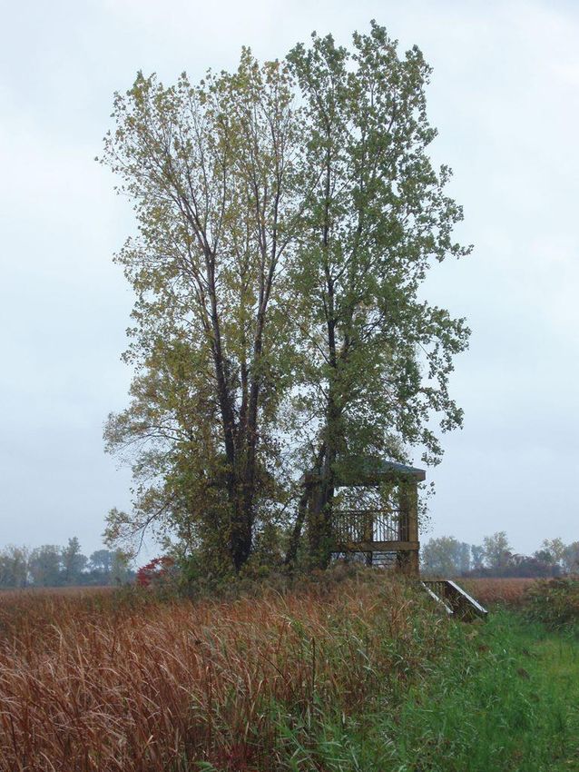
There is a public hiking trail (approximately 2.5 km) and a wildlife viewing tower located
along the top of the cross-dyke, accessible from the public parking lot (Figures 2, 5 and 6). The trail
extends beyond the viewing tower, along the top of the cross-dyke, and ends at Balmoral Line
(Figure 2).
Figure 4: Environment and Climate Change Canada – Canadian Wildlife Service office and other
structures at the St. Clair Unit, St. Clair National Wildlife Area, 2011
Photo: Jeff Robinson © Environment and Climate Change Canada
14 St. Clair National Wildlife Area Management Plan (Proposed)Figure 5: Public parking lot, interpretive signs and trail entrance, St. Clair Unit, St. Clair National
Wildlife Area, 2010
Photo: John Haggeman © Environment and Climate Change Canada
Figure 6: Viewing tower, St. Clair Unit, St. Clair National Wildlife Area, 2011
Photo: Jeff Robinson © Environment and Climate Change Canada
St. Clair National Wildlife Area Management Plan (Proposed) 15Bear Creek Unit
The Bear Creek Unit has no facilities. Infrastructure consists of signs, fencing, and gates and
items listed below for water management (Figure 3; Table 2).
Ontario’s Ministry of the Environment (MOE) in coordination with Environment and Climate
Change Canada’s Meteorological Service of Canada (ECCC–MSC) jointly operate an air quality
station to monitor air quality (ECCC–MSC) and precipitation (MOE) (Figure 3; Table 2). The air
quality station is located north of Meadowvale Line, and access to the station along a gravel
laneway is controlled by a locked gate (Figure 3; Table 2). The air quality station consists of
monitoring equipment housed in a small building and a tower (Table 2).
The Municipality of Chatham–Kent owns a small parcel of land outside of the NWA on the
northwest corner of the Snye cell in the Bear Creek Unit, used by the public to access the Snye
channel. ECCC–CWS maintains a fence to separate this municipal parcel from the NWA in order to
restrict access into the NWA (Figure 3).
Table 2: Facilities and Infrastructure at St. Clair National Wildlife Area
St. Clair Unit
Type of facility or infrastructure Approximate size Responsibility holder or owner
or number
Signs
911 sign #5633 Balmoral Line, RR 1 1 sign Municipality of Chatham–Kent
Pain Court
NWA identification signs 2 signs ECCC–CWS
NWA boundary signs 22 signs ECCC–CWS
NWA Entry Prohibited signs 25 signs ECCC–CWS
Interpretive signs 4 signs ECCC–CWS
Ducks Unlimited Canada (DUC) 1 sign ECCC–CWS
partner sign
DUC dedication sign 1 sign DUC
Buildings
Office/workshop 75 m² ECCC–CWS
Garage 65 m² ECCC–CWS
Lodge 100 m² ECCC–CWS
Stroh cabin 75 m² ECCC–CWS
Staff house 95 m² ECCC–CWS
Dykes and water control structures
Dykes ~ 10 km ECCC–CWS/DUC/adjacent
landowners
ARDA dyke ~ 3 km Municipality of Chatham–Kent
Pumphouse (domestic water system) 1.10 m² ECCC–CWS
Pumphouses – metal enclosures (not 2 pumphouses, 2 ECCC–CWS/DUC
in use) enclosures 2.4 m²
Pump 1 ECCC–CWS
Water control structures 4 ECCC–CWS/DUC
Public facilities
Gravel parking lot 150 m² ECCC–CWS
Wildlife viewing trail 2.5 km (length one ECCC–CWS
way)
Viewing tower – two-level ~3mL×4mW× ECCC–CWS
4mH
16 St. Clair National Wildlife Area Management Plan (Proposed)You can also read