ARDEN PRECINCT PARKING PLAN - PART 2 - EVIDENCE BASE - Engage Victoria
←
→
Page content transcription
If your browser does not render page correctly, please read the page content below
ARDEN
PRECINCT
PARKING
PLAN
PART 2 – EVIDENCE BASE
Client: Victorian Planning Authority

Version D – Final
12 August 2021
V200032

                                       Arden Precinct Parking Plan   Version D - Final – 12 Aug 2021
                                                                                                       1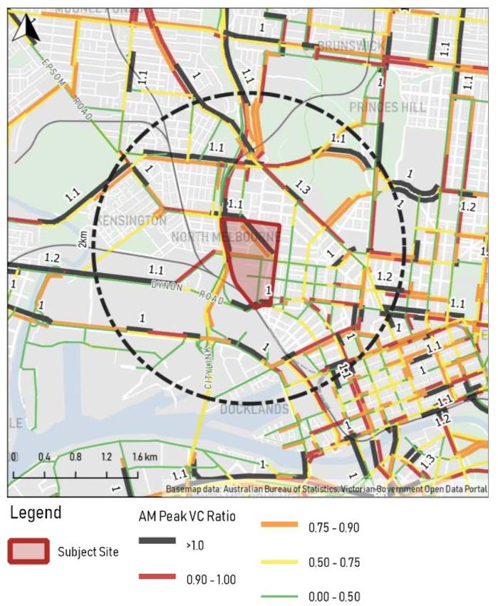
CONTENTS & STRUCTURE OF PART 2

Part 2 - Evidence Base

 01 Strategic Background                       Sets the policy scene for Arden, provides an overview of the structure plan together with how major projects link with
                                               the precinct. A case studies are presented as examples of recent relevant transport work.
 02 Existing Conditions & Best Practice        Sets out the existing transport conditions for Arden. A review of transport trends has been completed which
                                               concludes car use is dropping and is likely to drop further. A review of Movement & Place is also provided in the
                                               context of work completed for Arden. Lastly, a review of best practice solutions identifies innovative means of
                                               implementing car share, last-km servicing and Electric Vehicles.
 03 Trip Analysis and Mode Shares              Evidence is collated here to review if the mode share targets set for Arden are achievable. A first principles trip
                                               generation exercise is provided for later use when assessing the movement network.
 04 Structure Plan Movement Network Analysis   Provides a comprehensive review of the movement plan network set out in the draft Structure Plan, together with a
                                               general review of alignment between the objectives and strategies set out in relevant parts of the structure plan
                                               report.
 05 Arden Parking Demands                      Car parking is a travel demand management tool.
                                               This section shows that low car parking provision has a wide market basis and is therefore viable.
 06 Arden Parking Strategies                   This section shows that consolidated car parking, while efficient, will need public sector delivery and management, at
                                               least until the value of the model is accepted by the private sector.
 07 Recommendations & Next Steps               Collates recommendations from other sections of the report and draws a number of conclusions. The key ones being
                                               that the movement network is fit for purpose and the mode shares are achievable but a non-business as usual
                                               approach will be required.

                                                             Arden Precinct Parking Plan                                          Version D - Final – 12 Aug 2021
                                                                                                                                                                        2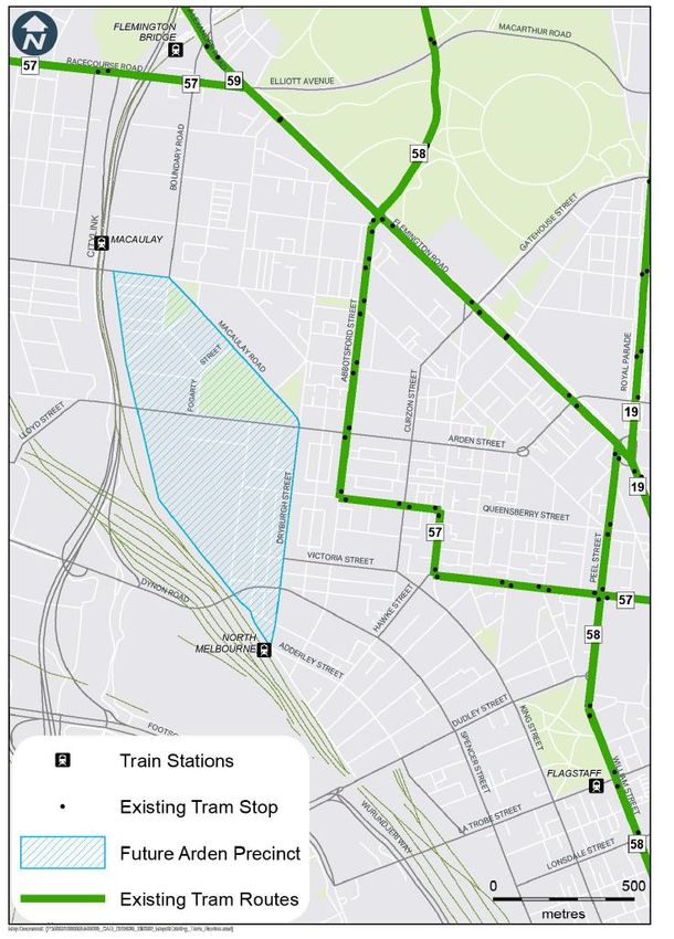
STRATEGIC BACKGROUND

1.1      PURPOSE OF THIS REPORT
1.2      REVIEW OF KEY STRATEGIES AND POLICIES
1.3      DRAFT ARDEN STRUCTURE PLAN BACKGROUND REVIEW
1.4      MAJOR PROJECTS
1.5      CASE STUDIES

This section of the report sets the policy scene
                                                                                           Part 2

                                                                                         01
for Arden, provides an overview of the structure
plan together with how major projects link with
the precinct. Case studies are presented as
examples of recent relevant transport work that
can be used to guide thinking for Arden.

                                                                               Evidence Base
                                                 Arden Precinct Parking Plan      Version D - Final – 12 Aug 2021
                                                                                                                    3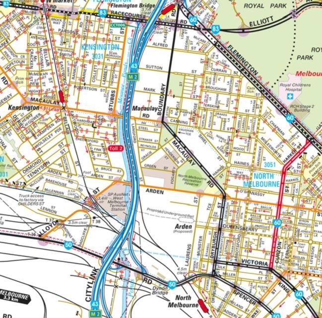
1.1 PURPOSE OF THIS REPORT

The purpose of this study is to assess the objectives and strategies set out in the draft Arden Structure Plan against key movement and parking
principles to inform preparation of the final Arden Structure Plan.
Arden is well placed to be an international innovation and technology precinct, given its rapid rail            Arden Transport Connections – Movement Network Plan
connections to the Parkville NEIC, the Melbourne CBD and Melbourne’s west. The Draft Arden Structure
Plan provides guidance on the delivery of 34,000 jobs and 15,000 residents by 2051.
With such numbers of new people working and living in the area, the existing transport infrastructure will
become more and more strained over time. While strategic transport infrastructure is currently being
constructed, such as the Metro Tunnel and West Gate Tunnel Project (WGTP), there is also a need to
deliver a range of more localised transport options.
The transport connections proposed in the draft Arden Structure Plan are shown on the movement
network plan to the right. With the new Arden Station being completed in 2025, the opportunity exists to
create a transit-oriented development that is highly accessible and has low car use.
Low car use will be key to delivering a dense mix of land uses in this precinct so that roads in the area are
not subject to unmanageable levels of congestion. This is coupled with the vision for Arden as a world-
leading sustainable precinct; a significant component will be how people choose to travel.
Accordingly, the Arden Vision sets an objective that 90% of travel to Arden will be by sustainable modes,
while only 10% will be made by car.
GTA Consultants has been engaged by the Victorian Planning Authority (VPA) to undertake a Movement
and Parking study in review of the Draft Structure Plan .The purpose of this engagement is to:
•   review if the transport goals and plans set out in the plan are realistic and achievable,
•   support best practice and innovation
•   realise the growth plans of Arden, including the employment and innovation goals of the Arden Vision
•   Prepare a Precinct Parking Plan to underpin a Schedule to the Parking Overlay for Arden
This report also sets out a parking strategy, including rates of parking provision, and how consolidated,
unbundled parking can be implemented to maximise the efficiency of car parking provision. This will                                             Source: Draft Arden Structure Plan 2020
reduce the need to build lots of car parking, resulting in increased and more affordable habitable space.

                                                                                 Arden Precinct Parking Plan
                                                                                                                                Version D - Final – 12 Aug
                                                                                                                                                      2021                                4
1.2 STATE POLICY CONTEXT

There are a number of key state policy documents which have guided the development of the draft Arden Structure Plan.

                                                                        Transport Integration Act
Overview
                                                                        The Transport Integration Act is Victoria's principal transport Act, bringing together the whole transport portfolio under
The following state strategic documents were reviewed                   one statute for the first time.
and the key points relevant to the Arden Precinct                       The Transport Integration Act combines Victoria’s transport portfolio under one single legislative act. It serves as a
Parking Plan have been highlighted.                                     strategic framework a for sustainable transport systems. The legislation guides the main decision-making process for
                                                                        other strategic transport planning documents within Victoria.
• The Transport Integration Act is the overarching
                                                                        The Act also includes six legislated objectives - social and economic inclusion; economic prosperity; environmental
  legislative policy for transport planning in Victoria                 sustainability; integration of transport and land use; efficiency, coordination and reliability; safety, health and wellbeing.
  and recognises that transport infrastructure and                      These are also underpinned by eight principles that further guide this decision making.
  policy changes influence land use.
• Plan Melbourne contains a set of principles and                       Plan Melbourne 2017-2050
  guidelines to shape Melbourne’s land use and                          Plan Melbourne will guide the growth of the city for the next 35 years. It sets the strategy for supporting jobs, housing
  transport planning into the future. The plan informs                  and transport, while building on Melbourne's legacy of distinctiveness, liveability and sustainability.
  the direction taken for strategic planning in the city.
                                                                        Plan Melbourne is a long-term plan designed to respond to the various challenges and opportunities Victoria faces
                                                                        between now and into the future. This plan revises the 2014 version of Plan Melbourne in order to better reflect current
• Movement and Place in Victoria recognises the                         policies and priorities. It is a blueprint for a Melbourne, whose population is forecast to reach 8 million by 2050.
  diverse role places play in planning which type of
  transport mode is most appropriate for any given                      The plan is structured around 9 principles to guide policies and actions, 7 outcomes to state the ambitions of the plan, 32
                                                                        directions to outline how the outcomes will be achieved and 90 policies to detail how directions will be turned into
  street or road. It recognises that all streets are                    actions.
  places in their own right, and in this context, there
  are different priorities in a place at any given time.
                                                                        Movement and Place in Victoria (2019)
                                                                        This document provides an overview of movement and place thinking and steps through the four modules in the
                                                                        Movement and Place Framework.
                                                                        The Movement and Place Framework takes a future-focused, multi-modal approach to network planning. It takes into
                                                                        consideration the diverse role places play in planning the types of transport modes appropriate to a local road or street.
                                                                        In this new language, roads and streets are defined by the context of a local place and assigned various ‘movement’ and
                                                                        ‘place’ classifications.
                                                                        The Framework offers a common language for coordinated transport planning between transport and planning agencies
                                                                        and local governments. It also provides a consistent approach to assessing the performance of the road and transport
                                                                        network, identifying project requirements and assessing project solutions.

                                                            Arden Precinct Parking Plan                                                         Version D - Final – 12 Aug 2021
                                                                                                                                                                                                   5
1.2 LOCAL POLICY CONTEXT AND PLANNING PRACTICE GUIDANCE

The local policy context and planning practice guidance have been reviewed and key points relating to Arden identified.

                                                                    Melbourne Transport Strategy 2030
Overview
                                                                    “Catering for growth and safeguarding prosperity will require planning for an efficient and sustainable transport network.”
The following local planning documents were reviewed
                                                                    The Melbourne Transport Strategy 2030 is an ambitious document that seeks to priorities active and public transport
and the key points relevant to the Arden Precinct                   within the City of Melbourne. The Strategy sets out a range of Strategies and actions to improve safety and accessibility
Parking Plan have been highlighted.                                 of the city for all. A number of actions specifically relate to Arden, including plans to expand public transport and include
                                                                    movement corridors through the precinct.
• The Melbourne Transport Strategy 2030 is the
                                                                    The Strategy addresses unlocking renewal areas with public transport and sets a long-term plan for Arden to be
  overarching transport vision for Melbourne. The                   supported with investment so that it can ultimately function in a similar way to the central city public transport nodes
  Strategy identifies Arden as an urban renewal area                today.
  to be prioritised for development from a low-
  intensity land use to a mixed-use precinct.
                                                                    Melbourne Planning Scheme
• The Melbourne Planning Scheme sets out the                        Planning schemes are legal documents prepared by the local council or the Minister for Planning and approved by the
  vision and strategic direction for the municipality               Minister. They contain policies and provisions that control land use and development. The Arden Precinct sits within the
  and through a range of specific objectives and                    Melbourne Planning Scheme. One of the objectives within the Melbourne Strategy 2030 was to review relevant sections
                                                                    of the Melbourne Planning Scheme and, if appropriate, initiate an amendment to ensure that development supports the
  policies, guiding where future land use and                       transport of residents and the broader community.
  development should be located across the city.
• Planning Practice Note 57 – The Parking
  Overlay (PPN57) provides guidance for councils
  on how to prepare and apply a Parking Overlay. It
  explains what the Parking Overlay is, what it does,
  when and how to use it and how to complete a                      Planning Practice Note 57 – The Parking Overlay
  schedule to the overlay.                                          Prior to preparing and implementing a Parking Overlay, councils need to prepare a Car Parking Plan which identifies the
                                                                    car parking needs and issues across the nominated area and sets out the car parking objectives which council seeks to
                                                                    achieve. The Car Parking Plan provides the strategic justification for the specific requirements (i.e. financial
                                                                    contributions, parking rates, design requirements) within the schedule to the Parking Overlay and will be referred to
                                                                    when the Parking Overlay is exhibited to the public through the planning scheme amendment process, and in this sense,
                                                                    it is a critical document when implementing a Parking Overlay and other parking management tools. A Car Parking Plan
                                                                    will often become a reference document to the Parking Overlay schedule it supports.

                                                        Arden Precinct Parking Plan                                                         Version D - Final – 12 Aug 2021
                                                                                                                                                                                              6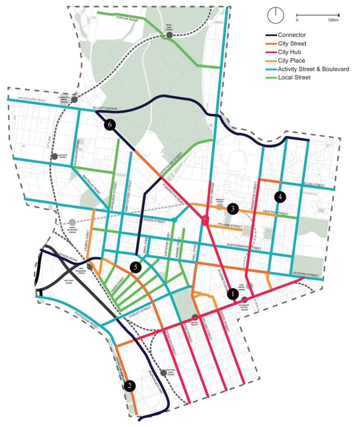
1.2 DRAFT ARDEN STRUCTURE PLAN BACKGROUND REVIEW

‘Arden will be a new destination for Melbourne, setting the standard for urban renewal. It will contribute to a future Melbourne
that is not only the world’s most liveable city, but also one of the most forward-looking.’ (pg. 8, Arden Vision)

Draft Arden Structure Plan - Victorian Planning Authority,    Figure 1.1: Arden Vision Targets                                      Figure 1.2: Arden Proposed Land Uses
2020
The Draft Arden Structure Plan builds upon the Arden Vision
(2018) and turns the visions set out in the document into
objectives and strategies to guide how the precinct should              RESIDENTS – 15,000
develop in the short, medium and long-term, along economic,

                                                                2051
physical and social dimensions. This document supersedes
the Arden–Macaulay Structure Plan (2012).                               JOBS-34,000

The plan is divided into nine (9) key objectives,
1.   Transforming Arden
2.   Designing a Distinctive Place
                                                                                      CARS
3.   Embedding Sustainable Change                                                     10%

4.   Prioritising Active Transport
5.   Celebrating Water
                                                                         ACTIVE
6.   Creating Diverse Open Spaces                                      TRANSPORT                         PUBLIC
                                                                          30%                          TRANSPORT
7.   Accommodating Diverse Communities                                                                    60%

8.   Investing in Community Infrastructure
9.   Delivering Arden

                                                                                                        Source: Arden Vision 2018                                  Source: Draft Arden Structure Plan 2020

                                                                                                                                                    Version D - Final – 12 Aug
                                                                         Arden Precinct Parking Plan
                                                                                                                                                                          2021
                                                                                                                                                                                                         7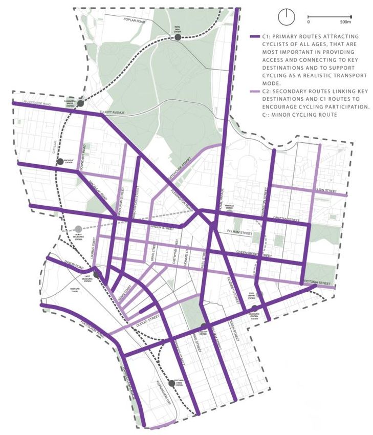
1.3 DRAFT ARDEN STRUCTURE PLAN BACKGROUND REVIEW

A substantial amount of work has been done to arrive at the mode share target aspirations for Arden. While ambitious, an active
hand in shaping access arrangements will make it an achievable aspiration.
Strategic Overview                                                      Key Document                 Overview and Relevance

The following strategies and documents outlined here are the            Arden Vision, VPA and        The Arden Vision sets out the priorities that will guide the next steps in the precinct’s development. It is the first
supporting documents for the Draft Arden Structure Plan. These
                                                                        COM (Final, 2018)            step in the implementation of local-level detailed planning for the Arden urban renewal precinct. The document
documents form the evidence base and inform the overall directions
of the plan.                                                                                         confirms shared state and local government intentions for the precinct and ultimately guides the Arden Structure
                                                                                                     Plan.
As an overall picture of the access strategy for Arden, the Structure                                Key conclusion: Car mode share target of 10%, sustainable mode share target of 90%
Plan recognises that there is limited capacity in the existing road
network with further limited scope to increase capacity.                Arden Transport              The report is a high-level strategic transport capacity study. The purpose of this study is to understand the ability,
Consequently, a 10% car mode share has been adopted by the              Capacity Assessment,         impact and resulting transport network arrangements needed to support the ultimate development in Arden. The
structure plan.                                                         GTA (Final, 2019)            study forms a gap assessment of the potential mode share for trips into Arden and what is needed to reach the
                                                                                                     aspiration targets set out in the Arden Vision.
Whilst a 10% mode share is unprecedented within the context of
                                                                                                     Key conclusions: Minimise car parking, reallocate road space from cars to sustainable modes, increase
Melbourne, the projected change in employment and residents
through to 2051 suggests that the mode share will naturally shift                                    public transport integration across the precinct.
towards 10%. To serve the remaining gap in trips to, from and
                                                                        Tram Option Feasibility      Based on the need to provide transport access beyond the future Arden Station, this study has investigated
around Arden, supply side measures have been outlined, along with
sustainable transport improvements.                                     Study, AECOM (Final,         these limitations in the context of a proposed series of tram extensions to the Precinct to help support public
                                                                        2019)                        transport networks.
The following key documents set out these improvements and                                           Key conclusions: Tram extensions connecting to and moving within Arden would have significant value
measures in detail, illustrating what is needed for Arden to achieve                                 for people using the precinct. A full business case should be developed.
its aspirational targets.
                                                                        Active Transport             The purpose of this Active Transport Study is to understand the existing conditions and key constraints and
                                                                        Investigation, AECOM         opportunities within the study area. This was used to identify the two highest priority walking and cycling
                                                                        (Draft, 2020)                corridors, along with the associated infrastructure requirements in order to provide a better active transport
                                                                                                     experience along these corridors.
                                                                                                     Key conclusions: The Arden Street and Canning Street corridors will be critical to delivering walking and
                                                                                                     cycling connectivity between Arden and adjacent precincts. Upgrades are proposed to improve walking
                                                                                                     and cycling use of these corridors
                                                                        Integrated Transport         The purpose of this study is to review the adequacy of transport and access proposals identified in the Arden-
                                                                        and Access Review,           Macaulay Structure Plan and other State and local policy to support the anticipated future development. This
                                                                        GTA (Final, 2013)            study outlines the future conditions of Arden as well as the projected minimum transport constraints and
                                                                                                     requirements for Arden to be viable.
                                                                                                     Key conclusions: Improvement to walking and cycling and public transport networks will be needed.
                                                                                                     Further work is required to refine car parking rates to proceed to a car parking overlay.
                                                                                                                                                                       Version D - Final – 12 Aug
                                                                                   Arden Precinct Parking Plan
                                                                                                                                                                                             2021
                                                                                                                                                                                                                         8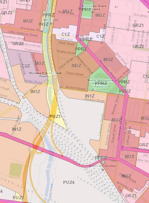
1.4 MAJOR PROJECTS

There are major infrastructure projects affecting the accessibility of Arden. Increased access by car makes it important to adopt
a precinct-level response to the potential for local traffic congestion and to capitalise on excellent public transport access.
Table 1.1: Major Projects Overview

Project                        Description                                                                              Arden Implications

                                                                                                                        The new station at Arden will provide high capacity underground trains, running along new
                                                                                                                        twin tunnels between Kensington and South Yarra. The project will see the installation of five
                                                                                                                        additional stations, including a new station within the Arden urban renewal area.
Melbourne Metro Rail Project
(MMRP)
                                                                                                                        The MMRP will alleviate congestion in the existing city loop by creating capacity for 500,000
                                                                                                                        more rail journeys peer week. Ultimately, more services will be able to be provided on all
                                                                                                                        metropolitan lines which will improve Arden’s accessibility by public transport.

                                                                                       Source: metrotunnel.vic.gov.au

                                                                                                                        The West Gate Tunnel will provide a second freeway river crossing and connection between
                                                                                                                        the Tullamarine Freeway and Geelong. It key aims are to divert freight traffic from local roads
                                                                                                                        in the inner west and improve access to Port of Melbourne.

West Gate Tunnel Project                                                                                                The associated transport modelling undertaken as part of the West Gate Tunnel Project and
                                                                                                                        presented in the Environmental Effects Statement, identifies an approximately 50% increase
                                                                                                                        on existing volumes on east-west roads such as Arden Street (ex. 6,000vpd), Victoria Street
                                                                                                                        (ex. 6,000vpd) and Queensberry Street (ex. 3,000vpd). As these roads are already near to
                                                                                                                        capacity, much of this traffic is forecast to be outside of the peak period.
                                                                             Source: westgatetunnelproject.vic.gov.au

                                                                                                                        These major road-based infrastructure improvements will continue to support high levels of
Broader freeway network        Monash Freeway and the North East Link are major state infrastructure projects           car travel in many parts of Melbourne. By increasing the capacity along existing corridors
upgrades                       that are underway.                                                                       and, given Arden’s location near to a freeway, if access roads are upgraded and parking
                                                                                                                        provided people will respond by driving to Arden.

                                                                                 Arden Precinct Parking Plan                                                         Version D - Final – 12 Aug 2021
                                                                                                                                                                                                                          9
1.5 CASE STUDIES – FISHERMAN'S BEND URBAN RENEWAL AREA

Fishermans Bend and Arden are comparable urban renewal sites with similar mode share aspirations.

Table 1.2: Fishermans Bend vs. Arden                       Delivering Fishermans Bend                                            Figure 1.3: Map of Arden and Fishermans Bend precincts
                                                           Much like Arden, Fishermans Bend is envisaged as an extension
 Characteristic      Fishermans Bend    Arden
                                                           of the central city. Close similarities are present between the two
                                                           urban renewal areas, which are outlined in Table 1.2.
 Distance to CBD                                           A major component of the Fishermans Bend urban renewal
                     4km                3km
 (Old GPO)                                                 project was to establish new benchmarks for sustainable
                                                           transport in inner-Melbourne. This would place the precinct
                                                           among the most sustainable transport cities in the world. A high
 Area                4.8km2             0.54km2            sustainable transport mode share target reflects an aim to shift
                                                           away from the car-centric ‘business-as-usual’ approach
                                                           (particularly for short-to-medium length trips). Adopting a
                                                           different approach is the only way to sustainably accommodate
 Proposed                                                  the population and employment levels envisioned.
                     80,000 people      15,000 people
 Residents                                                 Detailed investigations were undertaken as part of the review of
                                                           Fishermans Bend. These indicated that 2050 mode share
                                                           targets of 20% to private vehicle and 80% towards sustainable
 Population          16,667 residents   27,800 residents                                                                                                                      Source: GTA Consultants
                                                           transport are realistic and broadly consistent with comparable
 density             per km2            per km2
                                                           suburbs. These suburbs that are located within inner city              Ministerial Advisory Panel Transport Recommendations
                                                           Melbourne have a holistic public and active transport network,
                                                           and are implementing measures to minimize the use of private           •   Support the 80% sustainable mode share target by early
 Proposed Jobs       80,000 jobs        34,000 jobs        cars.                                                                      establishment of key cycling corridors
                                                           As such, given the similarities between two developments, it is        •   Support the implementation of maximum parking rates to
                                                           reasonable to assume that the strategies that have been                    limit reliance on private on-site parking
 Employment          16,667 jobs        63,000 jobs        developed for Fishermans Bend would be appropriate to                  •   The first stage of new tram routes should be completed
 Density             per km2            per km2            implement in Arden.                                                        within 5 years of adopting the Fishermans Bend Framework
                                                           It is worth noting that Arden is a much higher-density precinct            Plan
 Sustainable                                               than Fishermans Bend, having nearly twice the residential              •   Business cases should be prepared for trial precinct parking
 mode share          80%                90%                density and nearly four times the employment density. This                 stations of up to 300 car spaces
 target                                                    leads to a more compact urban environment, with shorter walk           •   Strictly limit parking to 0.5 spaces per dwelling pending
                                                           distances between buildings and comparatively greater access               evaluation of the precinct parking station trials.
                                                           to public transport compared to Fishermans Bend. This indicates
                                                           that there is potential to adopt lower rates of parking for Arden.
                                                                                                                                                 Version D - Final – 12 Aug
                                                                       Arden Precinct Parking Plan
                                                                                                                                                                       2021
                                                                                                                                                                                                        10
1.5 CASE STUDIES – BARANGAROO, SYDNEY
Barangaroo in Sydney is an example of an urban renewal site with an even lower car mode share target than Arden. It
demonstrates acceptability of this type of development when access by public transport and active modes is prioritised.
Table 1.3: Barangaroo vs. Arden Delivering Barangaroo Figure 1.4: Barangaroo Transport Network
Barangaroo is similar to Arden – both were previously home to
Characteristic Barangaroo Arden
an industrial and logistics precinct but are now witnessing a
step-change in land use as a result of urban redevelopment,
Distance to CBD catalysed by the introduction of a new rail corridor. Barangaroo1.5 CASE STUDIES – WEST MELBOURNE STRUCTURE PLAN
West Melbourne and Arden have some comparable features. However, Arden has a much more ambitious population and job
density. Evidence was presented to Planning Panel for low car parking rates, down to 0.3 cars per dwelling.
Table 1.4: West Melbourne vs. Arden Delivering West Melbourne Figure 1.5: West Melbourne Structure Plan Study Area
Characteristic West Melbourne Arden West Melbourne is directly adjacent to Arden and shares a
similar future vision and investment to support a growing
community.
Distance to CBD Similar to Fishermans Bend, it is worth noting that Arden is a
1.5km 3km
(Old GPO) much higher-density precinct than West Melbourne, leading to
a more compact urban environment, with shorter walk
distances between buildings and comparatively greater
Area 0.85km2 0.5km2 access to public transport. This indicates that there is
potential to adopt lower rates of parking for Arden.
Noting that the proposed residential and employment density
Proposed
9,000 people 15,000 people
for West Melbourne is significantly less than Arden, the
Residents transport strategies required to support Arden are required to
be more ambitious. Source: Studio Magnified
Population 10,500 residents 30,000 residents The key transport themes of the West Melbourne Structure
density per km2 per km2 Plan are: Planning Panel Transport Recommendations
• Improve walking and cycling routes to connect to major • Adopt the following car parking rates:
destinations.
Proposed Jobs 10,000 jobs 34,000 jobs • Expand and upgrade the cycling network. • 1-bedroom dwelling 0.3 spaces per dwelling
• Advocate for public transport investment. • 2-bedroom dwelling 0.45 spaces per dwelling
• Convert some car parking to public open space. • 3-bedroom dwelling 0.6 spaces per dwelling
Employment 11,800 jobs 68,000 jobs
Density per km2 per km2
• Update off-street private car parking requirements to • Everything else 0.5 spaces per 100sqm
support a less car dependent transport system.
Given the vision and aspirations for Arden are more • Implement rates for parking provision and control design
Sustainable outcomes in a Schedule to the Parking Overlay.
mode share N/A 90% ambitious, it is reasonable to assume that strategies and
target actions developed for transport to support the redevelopment
of Arden will need to be more ambitious.
Version D - Final – 12 Aug
Arden Precinct Parking Plan
2021
12EXISTING CONDITIONS & BEST
PRACTICE
2.1 EXISTING CONDITIONS
2.2 TRANSPORT TRENDS
2.3 BEST PRACTICE SOLUTIONS REVIEW
This section sets out the existing transport conditions for
Part 2
02
Arden. A review of transport trends has been completed which
concludes car use is dropping and is likely to drop further. A
review of Movement & Place is also provided in the context of
work completed for Arden. Lastly, a review of best practice
solutions identifies innovative means of implementing car
share, last-km servicing and electric vehicles.
Evidence Base
Arden Precinct Parking Plan Version D - Final – 12 Aug 2021
132.1 EXISTING CONDITIONS IN THE ARDEN PRECINCT
Arden currently consists of mainly industrial land with some residential development and transport infrastructure provision.
The Structure Plan targets a substantial shift in land use over time.
Land Use Transport Network Figure 2.1: Existing Land Zoning
The Arden area was historically established as a Arden is serviced by three buses – the 403 along Arden
manufacturing and industrial district, with a provision of Street, the 402 along Macaulay Road and the 401 between
housing for working class families. The streets in the area Parkville and North Melbourne Station. These services are
were designed accordingly, generally with wide roads, large infrequent and largely operate during the weekdays only.
street blocks and limited access by foot or bicycle, including
across the railway lines and Moonee Ponds Creek. To the north-west of the precinct, Arden is serviced by the
Upfield Line at Macaulay Station. Services along this line
The residents and workers in the area benefitted from good operate every 20-30 minutes throughout the week. To the
access to key roads, tram services and railway stations, south of the precinct, North Melbourne Station functions as a
including at North Melbourne, Macaulay, Kensington, major rail interchange and offers turn-up-and-go services
Newmarket and Flemington Bridge. every day.
Since the early 2000’s, the areas surrounding Arden have To the east of the precinct, the route 57 tram runs along
changed in many ways. New housing developments, including Abbotsford Street and operates every 10-30 minutes
public and community housing, have increased the number of throughout the week and offers a frequent service to the CBD
people living in the east of Arden as well as in the Macaulay and parts of the Parkville NEIC.
area, and introduced some new community facilities in the
area. Bicycle routes exist along Queensberry Street and Macaulay
Construction of the elevated CityLink freeway has also Road as well as the Capital City Trail along the Moonee
introduced new complexities to the creek and rail interface, in Ponds Creek. Most road cross-sections are wide enough to
terms of both amenity (i.e. overshadowing and noise) and the cater for high-quality safe bicycle lanes.
ability to make changes to the way people access the area in
the future (i.e. rail).
Other areas including Arden itself remain relatively
unchanged, with terrace housing comprising much of the
residential area in the east and industrial uses occupying
large parts of Arden Central. From a transport perspective,
this also means that many physical characteristics remain Source: VicPlan
largely unchanged.
Version D - Final – 12 Aug
Arden Precinct Parking Plan
2021
142.1 EXISTING WALKING AND CYCLING CONDITIONS
The existing walking and cycling experience is compromised by large block sizes, poor pedestrian crossings and high vehicles
speeds.
Figure 2.2: Existing Cycling Network
Walking
Due to the urban nature of the study area, the footpath
network is dense and interconnected. However, long wait
times at some traffic signals can be perceived in some areas
as barriers to the convenience of walking. City of Melbourne
has classified the intersections within the study by their
waiting times, with signal cycles exceeding 75 seconds
considered less desirable for pedestrians and cyclists.
Research undertaken by the NZ Transport Agency[1], shows
that if delays are perceived to be too long (i.e. greater than 30
seconds between walk signals), it may increase non-
compliant (risk-taking) behaviour, specifically jaywalking.
Cycling
The study area is well covered by cycle lanes. However, the
majority are not fully protected from traffic and car parking,
and only a few sections are fully kerb-protected cycle lanes.
The Capital City Trail is a strategic cycling ring corridor that
connects several areas of metropolitan Melbourne. This
corridor connects into North Melbourne via Arden Street. The
University of Melbourne can also be accessed from this
corridor along an off-road path via Princes Park. Royal Park
also provides a mesh of off-road trails and paths which
connect directly to the Royal Children’s Hospital. The existing
most protected on-road corridors are Queensberry Street,
Abbotsford Street and Swanston Street between the
University of Melbourne and Queen Victoria Market.
[1] Reducing pedestrian delay at traffic signals, NZTA, 2011 Source: City of Melbourne Transport Strategy
Version D - Final – 12 Aug
Arden Precinct Parking Plan
2021
152.1 EXISTING TRAM NETWORK CONDITIONS
The existing transport network consists of a railway station at either end of the Arden Precinct, as well as several tram routes
that run outside its eastern and northern peripheries.
Figure 2.4: Existing Tram Network
Train Tram
The existing tram network in the study area is shown in the
The existing North Melbourne station and Macaulay station accompanying map. A single existing tram route runs through
currently serve the study area in close proximity to the Arden North Melbourne: Route 57 West Maribyrnong to Flinders
Precinct. Macaulay station is on the Upfield Line, whilst North
Street station. It operates along Victoria Street, Errol Street,
Melbourne is an interchange station for Craigieburn, Sunbury,
Upfield, Werribee. Queensberry Street and Abbotsford Street. The route 57 tram
is the closest operating tram to the Arden Precinct. There are
Bus three tram routes which run along the border of North
Melbourne and West Melbourne:
Route 401 (North Melbourne station - Melbourne University
Loop via Royal Melbourne Hospital) is an express bus service • Route 59 Airport West to Flinders Street station.
between the hospital precinct, Melbourne University and • Route 58 West Coburg to Toorak.
North Melbourne station. It travels along Victoria Street, • Route 19 North Coburg to Flinders Street station.
Dryburgh Street and Arden Street.
Figure 2.3: Existing Train Network
Route 402 (Footscray Station – East Melbourne via North
Melbourne) runs through North Melbourne along Macaulay
Road, Shiel Street, Haines Street, Arden Street and Harcourt
Street.
Express Shuttle Route 403 (Footscray Station – Melbourne
University via Royal Melbourne Hospital) runs in off -peak
periods through North Melbourne along Arden Street,
Dryburgh Street and Dynon Road.
Source: AECOM
Source: AECOM
Version D - Final – 12 Aug
Arden Precinct Parking Plan
2021
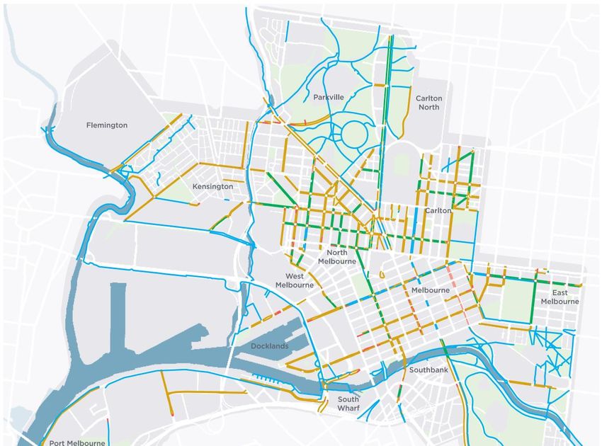
162.1 EXISTING ROAD NETWORK CONDITIONS
The existing road network is well-developed, with access to the freeway and arterial road network located nearby. The road
network is currently congested during peak periods, which will make car use less attractive compared to other modes as
development densities increase.
Road Network Figure 2.5: Existing Road Network Figure 2.6: 2016 AM Peak 2hr Volume / Capacity Plot
The existing road network in the vicinity of Arden precinct is
shown in Figure 2.5. The precinct is in close proximity to
Melbourne’s arterial road network. CityLink provides access
from the study area to the airport in the north, industry to the
west and the Port of Melbourne to the south. The precinct has
access to CityLink via the Racecourse Road and Dynon Road
interchanges.
Racecourse Road is a designated east-west arterial road,
while the north-south through route of Macauley Road is an
arterial link. City access is provided primarily via Macaulay
Road and Dryburgh Street.
Generally, Arden is difficult to access by car during peak
hours. Major arterial roads in the surrounding area, such as
Macaulay Road, Spencer Street, Flemington Road, Dynon
Road and Racecourse Road are congested. This is confirmed
by strategic modelling (VITM) shown in Figure 2.6, the road
network proximate to and connecting Arden generally has
sections along each arterial road that are highly congested,
i.e. V/C > 0.9.
This results in rat-running through local streets within the Source: Melway Publishing
precinct, as drivers attempt to avoid congested intersections.
Source: VITM
Version D - Final – 12 Aug
Arden Precinct Parking Plan
2021
172.2 TRANSPORT DEMAND TRENDS
Melbourne as a city is trending towards lower car usage. Changes in employment types, car ownership as well as the current
COVID-19 pandemic are driving factors in this change.
Change in Employment Types Car Ownership Across Victoria is Trending Downward Car Ownership in the Melbourne LGA is Trending Downward
The Arden area has historically been associated with While there are more cars registered to drive on the road each Arden is to be the home of 15,000 people by 2051, living in high
manufacturing and industrial employment. A core focus of the year in Victoria, the number of car registrations on a per person density residential buildings. Analysis of ABS Census car
Arden Vision is a transition toward white collar employment basis reached a peak in 2016 and has begun to trend downward ownership indicates a drop of 0.1 cars per dwelling between
sectors (Health, Life-sciences, Education and Technology). over the last four years, see Figure 2.8 2011 and 2016 censuses. This includes the historic apartment
stock. The new apartments that have been built, which
To understand this change, analysis was undertaken on how Car ownership depends on a range of economic factors and contributed to a fall in the average car ownership, have been
people travel to work to blue-collar and white-collar jobs in inner- there is a low number of sample years from which to project provided with much fewer cars per dwelling, as shown below:
city Melbourne suburbs. These trends depend on a number of forward. Based on the available information, 2051 car ownership
factors (such as availability of car parking, access to public could be 15% less than at 2020 on a per person basis, a level • 2011: 32,500 apartments, 0.75 cars per household
transport, nature of work, ability to live locally and so on), but not seen since the early 1990’s.
broadly speaking, provide an indication of how occupation can • 2016: 50,000 apartments, 0.65 cars per household
influence travel choices in a similar setting to Arden. Figure 2.8: Vehicle Registrations in Victoria 2010 to 2020
• Change: 17,500 apartments, 0.45 cars per household
Figure 2.7: Mode Share to Work by Occupation with a
Destination in Inner City Melbourne The COVID-19 Pandemic is Likely to Change Movement
One of the “silver linings” of the COVID-19 pandemic is that is
likely to change the way people work and, consequently, how
much time they devote to travel to and from their place of work.
The pandemic has effectively forced businesses to breakdown
barriers to enable people to do their job from home. Coupled
with this, many businesses have implemented a curtailed
working week, which has given employees greater work/life
balance that will be difficult to relinquish[1].
In addition, early research[2] is pointing towards a decrease in
Victoria’s population growth by 2040, compared with earlier
forecasts.
Source: ABS Motor Vehicle Census, to 31 January 2020 (Passenger Car)
Summary
Source: ABS Census 2016 [1] The Work-Life Rebalance, a whitepaper by LVI Associates, October 2020 These factors add-up to a reduced need to travel and a reduced
Sample size: White Collar 142,627 people, Blue Collar 29,264 people [2] Queensland Centre for Population Research, Working Paper No 2020/03
likelihood of owning, or needing to own a car, compared to
current characteristics.
Version D - Final – 12 Aug
Arden Precinct Parking Plan
2021
182.2 TRANSPORT TRENDS - LIVING AND WORKING LOCALLY
A key part of increasing walking and cycling mode shares is to make decisions that support people to live locally. This is
supported at the metropolitan-wide policy level through the idea of a 20-minute neighbourhood, as set out in Plan Melbourne.
20-Minute Neighbourhoods Figure 2.9: People that live and work in the same suburbs Transport and land use policy
of Melbourne, 2011 - 2016
The realisation of 20-minute neighbourhoods, Creating a successful self-contained suburb
places where people can live and work and meet requires a number of policies to work together,
most of their daily needs, is a key component of including:
Plan Melbourne. • Land use planning needs to create a mix of
uses to satisfy residential and commercial
The shorter the trip the more likely that it will be
demand.
walked or cycled. Given that the mode share
targets for Arden aim to achieve a high number of • Land uses need to focus on local
trips by walking and cycling, ‘self contained’ trips catchments and not those that draw people
within the precinct should form an important by car from across Greater Melbourne and
aspect of both land use and transport planning. regional areas (this is not something
currently considered by our planning
Self-containment is the idea that an area can scheme).
provide for a persons’ daily needs, reducing the • Economic investment / incentives need to
need to travel long distances. It is achieved create local employment opportunities that
through the concentration of housing, services cater for the populations that live in the area
and employment options for residents within their – e.g. the inner city is more likely to be
local municipality. The degree of self-containment professional services workers.
of a region impacts transport demand to and from
the region, as employment outcomes and service • Transport planning should prioritise local
Source: ABS Census 2011 & 2016 transport links and potentially constrain
distribution influence travel distance and mode
shares. connection to the strategic network.
Figure 2.9 shows a comparison of 2011 and 2016
ABS Census data. Melbourne has seen
increased self-containment rates (as reflected by
the proportion of people living and working in the
same suburbs) , with one of the largest increases
of 4% seen in Inner Melbourne, the sector
inclusive of Arden, with a 73% containment rate.
Arden Precinct Parking Plan Version D - Final – 12 Aug 2021
192.3 BEST PRACTICE SOLUTIONS REVIEW – MOVEMENT & PLACE
The Movement & Place framework steps away from traditional prescriptive functional road hierarchies, towards a system that
considers how people use different parts of the transport network and the benefits they derive.
The Movement & Place Framework
The Movement and Place Framework, developed by Department of Transport (DoT, 2019), provides a Movement layers in the DoT
balanced approach to allocating road space by mode of transport, having regard to its movement and
place function at a network operating level. These ‘functions’ should be aligning with the community’s Movement & Place framework
vision for both transport and land use, rather than just replicating the current conditions.
“Fundamental to movement and place thinking is recognising that streets perform multiple functions.
Transport links not only move people from A to B, they also serve as key places and destinations in
their own right.
There is also a natural tension between these two functions, As a movement corridor, every link aims
to minimise travel time and keep people and goods moving. Contrarily as a destination, it aims to
increase visitor dwell time.” (DoT, 2019)
A core component of the framework is the identification of modal networks and their relative
importance. Each mode would ultimately have its network prioritised on a scale of 1 to 5, M1 being a
route of state or national significance, and P5 being a place of local significance.
Application of Movement and Place to Arden
A comprehensive Movement and Place framework
assessment has been completed by Arup[1] which
captures the Arden precinct. Selected aspirational
networks are shown overleaf.
This framework has been used by AECOM[2] to
develop street typologies for the Arden Street and
Canning Street corridors.
[1] North Melbourne, West Melbourne and Docklands Movement and Place
Strategic Plan: Strategy and Assessment Framework, Arup, 2019
[2] North Melbourne, West Melbourne and Parkville: Active Transport
Investigation, AECOM, 2020
Version D - Final – 12 Aug
Arden Precinct Parking Plan
2021
202.3 BEST PRACTICE SOLUTIONS REVIEW – MOVEMENT & PLACE
Aspirational movement networks for Arden are set out in the Movement and Place Strategic Plan.[1]
Figure 2.10: Aspirational Street Types Figure 2.11: Aspirational Walking Classification Figure 2.12: Aspirational Cycling Classification
ARDEN ARDEN ARDEN
PRECINCT PRECINCT PRECINCT
[1] North Melbourne, West Melbourne and Docklands Movement and Place Strategic Plan: Strategy and Assessment Framework, Arup, 2019
Version D - Final – 12 Aug
Arden Precinct Parking Plan
2021
212.3 BEST PRACTICE SOLUTIONS REVIEW – KERB SPACE REPURPOSING & LOW-IMPACT LAST-KILOMETRE SERVICING
On-street parking should also consider the need to provide for more sustainable travel modes. A flexible approach to kerbside
space will ensure parking is provided for the right uses at the right time.
Different forms of vehicles require kerbside space Case Studies – Repurposing Car Parking Spaces
With a need to provide greater space for pedestrians on
footpaths, declutter walking environments and introduce more
trees and landscaping, there is a need to make use of what
have been car parking spaces for other modes and activities.
This covers not only dedicated parking for motorcycles and
bicycles but also potential new modes such as e-scooters.
Repurposing parking spaces to provide pocket parks and
seated landscaping areas is also a means of supporting
placemaking and on-street activities.
Flexible kerbside spaces Haringey London, UK Bike Hanger - bike lockers for six Pop up seating and dining area in Adelaide
bicycles that occupies less than one parking space. These are
Having “parking” spaces that can be used in a more dynamic oversubscribed
way for different uses is also a way to maximise the turnover
and use of potentially valuable space. There are examples of
areas set aside for loading or disabled parking that can easily
transition at times to use as footpaths or for market stalls. The
concept of a space being purely set aside for parking is
increasingly being challenged.
Implications for Arden
• Car parking spaces can be repurposed to accommodate
street furniture and create wider footways with less clutter.
• Make use of road space to accommodate service vehicles
in the street rather than on-site, making better use of
developable land. Part time loading available footpath other times of day, On-street bike parking replacing car park, City of Melbourne
London
Version D - Final – 12 Aug
Arden Precinct Parking Plan
2021
222.3 BEST PRACTICE SOLUTIONS REVIEW – HIGH ACCESSIBILITY AND LOW VEHICLE USE
There are many benefits to removing the ability for people to drive cars through a neighbourhood. Active travel is naturally
elevated, vehicle speeds decrease, and the streets are returned to the communities they serve.
Increase Active Travel by Restricting Vehicle Access Case Studies – Streatham Hill Low Traffic Neighbourhood
Limiting or removing vehicle access within a neighbourhood Similarities to Arden
pushes vehicle priority down the modal hierarchy.
• Limited access from surrounding major roads
This can be achieved by straightforward and cost-effective
means: • Vehicle access maintained but not wholly prohibited
• Modal filters (restrict cars, permit everything else). • Access within the neighbourhood becomes more
• One-way streets. convenient by active travel
• Bus gates.
• Width restrictions to limit heavy vehicle access.
• School streets (to prevent parents getting close for drop- Benefits of Similar Schemes
off and pick-up).
A low traffic neighbourhood can be supported by gateway Walking +32 minutes per week
treatments such as
• Raised intersections (continuous footway). Cycling +9 minutes per week
• Parklets.
• Zebra crossings or pedestrian operated signals. Life expectancy +7 months
Emergency vehicle access[1]
Examples from the UK indicates that emergency services are Economy +30% retail, -17% vacancies
generally positive about such schemes. They are statutory
consultees and typically see no change in response times,
with most common concerns raised being placement of Vehicles -56% residential, -38% overall
lockable bollards for access during extended incidents, and
their GPS systems being updated appropriately. These issues
Community +216% static street use
can be managed with planning and coordination with local
emergency services managers.
[1] Living Streets, Low Traffic Neighbourhoods, UK 2018. Source: London Borough of Lambeth
Version D - Final – 12 Aug
Arden Precinct Parking Plan
2021
232.3 BEST PRACTICE SOLUTIONS REVIEW – CAR SHARING AND ELECTRIC VEHICLES
Car share schemes allow limited space to be shared by multiple users and provide alternative access to car ownership where
alternative transport options are unavailable.
How Can it be Made Easier to not Own a Car? Electric Vehicle Ownership is Set to Increase Case Studies – Share Car Charging Bays (Singapore)
Car share services are established in an effective way across The traditional idea of a petrol or diesel driven car is In 2017, the Land Transport Authority (LTA) implemented a
Melbourne. The premise is that shared vehicles are available changing. The increasing use of hybrid electric vehicles, and nation-wide EV carsharing scheme consisting of 1,000
to rent on an hourly basis, replacing the need to own a vehicle pure electric vehicles (EVs) is changing vehicle design and vehicles and 2,000 charging points. Of these charging points,
for people who use a car rarely. requirements. In Europe, diesel and petrol cars are being 400 of them will be open for public use. The charging of
progressively banned across various countries. Within the private EVs is based on an hourly rate of $1-2/hour or
Car Share Services Promote Shared Use of Space United Kingdom, petrol and diesel cars will be banned from alternatively $20 a year as part of a subscription.
2035, building upon existing legislation for fuel efficient
Cars spend the majority of the time unused and therefore By combining car sharing and EV charging infrastructure, the
vehicle standards as well as carbon emissions-based
represent an inefficient use of space and resources. Car program encourages both the adoption of EVs for those who
congestion charges in areas such as London.
share provides an alternative access to transport where want to own their own private vehicle by providing more range
alternative options are not available. It is estimated that by 2025, EVs will be of a similar cost to and coverage across the island as well as providing a low
petrol or diesel vehicles[1], reducing the cost barrier to their emissions option those who only need to use a car
Local Trips that Would Otherwise be Made by Active and
adoption. Beyond pricing, as a barrier to EV adoption rates, occasionally.
Public Transport may be replaced by Car Share Use
challenges remain on supporting infrastructure for EVs. A
Easy access to a vehicle can mean, rather than replacing higher share of EVs in the local area will pose problems as to
trips made by privately owned cars, they replace trips how these vehicles will be charged, where will there be
otherwise made by active or public transport modes, in turn charging points, how to retrofit this infrastructure as well as
adding to the congestion and parking demand how much charging these vehicles will cost.
Strategies or Initiatives Implications for Arden
• Car share could contribute to reduced car parking
If VPA/City of Melbourne wants to implement and encourage
it should be free for companies to set up (or a nominal setup • Car share still contributes to vehicle trips
fee to cover the cost of signs and administration). In addition: • It is realistic to assume that nearly all vehicles will be
• Car share should be encouraged off-street in-lieu of car electrically powered within the lifetime of the structure plan
parking. • It is therefore realistic to plan for vehicle charging to be
• The vehicles should be treated in the same way as supplied at long-term parking locations.
resident long-term parking in terms of locating within • Advent of AV’s and mobility as a service (MaaS) could
resident streets. lead to greater uptake of subscription models currently in
• Council should develop a policy basing this on future place for car share, contributing to lower on-site parking [1] https://theicct.org/publications/update-US-2030-electric-vehicle-cost
rather than current demand. needs.
Version D - Final – 12 Aug
Arden Precinct Parking Plan
2021
242.3 BEST PRACTICE SOLUTIONS REVIEW – WAYFINDING
Wayfinding is a simple solution to improving access to car parking along with increasing user comfort and safety.
How can it be made easier to find parking? Case Studies – VMS at South Melbourne Market
Improved wayfinding to parking can assist with reducing Variable Message Signs (VMS) are used at South Melbourne More notably, the wayfinding system incorporates both
frustration and congestion. People spend a large amount of Market to manage the seasonal demand for parking in the Council owned and private off-street parking spaces. By
time looking for a parking space, adding to frustration and precinct. Decision points at key intersections feature signs taking an integrated precinct-level approach to parking,
increasing the number of vehicles on the roads. Improved indicating the number of free spaces available at car parks. drivers have a clearer understanding of where to go and
wayfinding can assist in addressing this issue. Dynamic These signs are further reinforced with static signage to direct where to park, minimising the level of congestion created by
signing to off-street car parks, and areas of on-street parking drivers to the corresponding car park. vehicles looking to park.
has been demonstrated to improve usage of parking spaces
whilst reducing circulation trips. Such systems are widespread
in Europe, but still have limited uptake in Australia.
Whilst they can be expensive and there are complexities with
different ownerships of off-street car parking, these barriers
can be overcome. Often basic levels of static signing to off-
street parking is limited and even locals can be unaware of
provision. Ensuring sufficient informative and consistent
signing can improve car park usage. Telling users about the
number of spaces, if it is restricted or unrestricted all provide Source: GTA 2020 Source: GTA 2020
valuable information to users.
Making parking safe Implications for Arden
Everyone has the right to feel safe and comfortable within • Car park occupancy monitoring linked to VMS will lead to
their community. However, pedestrian pathways to access car increased parking efficiency (do more with less).
parking can be an intimidating part of the journey home for • Reduced user frustration
many people. Wayfinding must consider the logical principles • Reduced vehicle congestion on roads and within car parks
around what makes an area comfortable space (especially at
night). Crime Prevention Through Environmental Design • Provides increased user comfort and safety through
(CPTED) is not an exact science. It must be incorporated into adoption of CPTED principles
Source: GTA 2020
every wayfinding project with interventions prepared on a
case-by-case basis.
Version D - Final – 12 Aug
Arden Precinct Parking Plan
2021
252.3 BEST PRACTICE SOLUTIONS REVIEW – DIGITAL TECHNOLOGIES
Kerb space can be better utilised with smart technologies.
A Rigid use of On-street Spaces Case Studies – Grid Smarter Cities (UK)
Currently in Melbourne and across Australia, kerbside spaces Grid Smarter Cities is a digital approach to managing
are managed by fixed signage that requires updating each kerbside spaces in urban areas. By combining geolocation
time a change is needed. The signage usually indicates the technologies with dynamic resource allocation systems, it is
restrictions placed on the space including the duration it possible to increase the flexibility and efficient usage of on-
applies to. Combining multiple conditions requires combining street space.
multiple pieces of information onto a small sign, representing
a poor and confusing user experience for drivers. Whilst a typical on-street loading bay or parking space has a
fixed use as indicated through signage or line marking, Grid
These fixed conditions may also not be representative of the Smarter Cities proposes to substitute these with geofenced
needs of the local community as this can change over the locations that are updated and communicated real time
span of not only a day, but also over the year (e.g. a local through smartphone and desktop applications.
event may require more loading or delivery space than what
the kerbside space is signposted for). A key feature is the use of bookings to allocate resources
across a defined range of spaces as well as to aid in
A Modern Approach for Arden wayfinding. By guaranteeing a specific parking/loading space
to a user within a certain timeframe, congestion caused by
The case study presented opposite, demonstrates a new way users circling roads for a space is minimised.
of allocating and managing on-street parking provision for a
range of needs. Benefits include At the same time, this system can also be used to reassign
spaces as needed both on-street and off-street as needed on
• Efficient, dynamic use of road space that links with the a real time basis. Additional parking and loading space can be
precinct’s innovation hub aspirations created as needed if demand or a situation requires it by
• Links with last-km servicing and providing for vulnerable creating virtual parking or loading spaces demarcated by
parking user groups, such as people with disabilities geofenced areas.
• Reduces enforcement administrative burden. The system also minimises management overhead created
by issuing permits and exemptions as these can now be done
in a unified system all whilst providing accurate and detailed
data to authorities.
Source: Grid Smarter Cities 2020
Version D - Final – 12 Aug
Arden Precinct Parking Plan
2021
26TRIP ANALYSIS AND MODE
SHARES
3.1 PLAUSIBILITY OF MODE SHARE TARGETS
3.2 TRIP GENERATION ASSESSMENT
Building on the Arden Transport Capacity Study
Part 2
03
(an earlier report by GTA), further supporting
evidence is collated here to demonstrate the mode
share targets for Arden are achievable. A first
principles trip generation exercise is also provided
for later use when assessing the movement
network.
Evidence Base
Arden Precinct Parking Plan Version D - Final – 12 Aug 2021
27You can also read