Hastings Town Centre and White Rock - Retail and Leisure Assessment & Urban Design Analysis
←
→
Page content transcription
If your browser does not render page correctly, please read the page content below
HASTINGS TOWN CENTRE AND WHITE ROCK STUDY: FINAL REPORT

Hastings Town Centre and White Rock
Retail and Leisure Assessment &
Urban Design Analysis

FINAL REPORT: MARCH 2016

                           Nicole Collomb
                           Landscape Architect

                                 1                                                           gva.co.uk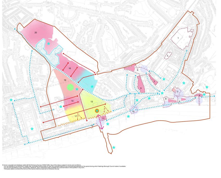
HASTINGS TOWN CENTRE AND WHITE ROCK STUDY: FINAL REPORT

2                                                gva.co.uk
HASTINGS TOWN CENTRE AND WHITE ROCK STUDY: FINAL REPORT

CONTENTS

Section 1: Introduction                                           5
1        Introduction                                             6

Section 2: The Context                                            7
2        The Context For the Study                                8

Section 3: Urban Design Analysis & Opportunities                  27
3        Urban Design Analysis                                    28
4        Summary of Key Urban Design Issues and Recommendations   48

Section4: Retail and Leisure Assessment                           60
5        Policy Framework                                         61
6        National Market Trends                                   64
7        Sub-regional context                                     66
8        Hastings Town Centre                                     68
9        Retail need projections                                  76
10       Commercial Leisure Assessment                            83

Section 5: Conclusions                                            90

Appendices (see seperate appendix document)
Appendix 1: Comparison Goods Need Projections
Appendix 2: Convenience Goods Need Projections

                                                                       3                                                gva.co.uk
HASTINGS TOWN CENTRE AND WHITE ROCK STUDY: FINAL REPORT

4                                                gva.co.uk
HASTINGS TOWN CENTRE AND WHITE ROCK STUDY: FINAL REPORT

SECTION 1: INTRODUCTION

                          5                                                gva.co.uk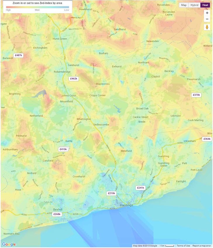
HASTINGS TOWN CENTRE AND WHITE ROCK STUDY: FINAL REPORT
1 INTRODUCTION
growth and change in Hastings; to build on its positioning as a destination, and to enhance the
BGVA were instructed by Hastings Borough Council to prepare the Hastings and White Rock local economic benefits.
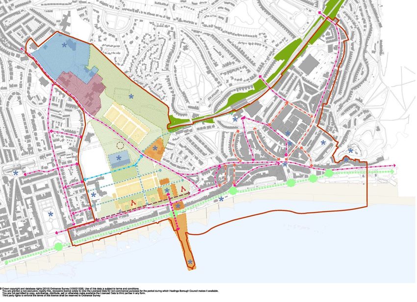
Study. The study area is shown in figure 1.
FIGURE 1: HASTINGS & WHITE ROCK STUDY AREA 2
Hastings Town Centre and White Rock areas have been identified by the Council as key to the
continued economic and cultural regeneration of the Borough. The Council is looking to adopt
an Area Action Plan (AAP) as part of the suite of Local Plan documents – identified in the Local
Development Scheme.
In line with this, Hastings Borough Council (HBC) instructed Bilfinger GVA team 1 to prepare a
comprehensive assessment into the needs, capacity, strengths and opportunities of the Hastings
Town Centre and White Rock area, and to derive key evidence and recommendations to inform
the Council’s Area Action Plan (AAP).
This report forms a major evidence base for the Council’s Area Action Plan (AAP), which is to be
provisionally titled ‘Hastings Town Centre and White Rock Area Action Plan’. It provides detailed
baseline analysis and identifies opportunity sites in the town centre, which can then be used as a
tool for focussing the early actions of the new governance and delivery vehicles.
The main objectives of this study are to:
• Develop and agree Planning Policy recommendations in relation to the study area.
• Assess value and benefits that might be generated in the future
• Encourage Investments: Developing a brief for using this information to encourage creative
private investment through the Area Action Plan (AAP) process.
The following report presents the key components of this study which include retail needs/ Extended study
capacity assessment of Hastings Town Centre, leisure and facilities assessment, an urban design area boundary
analysis and identifying opportunity areas for the study.
The project components include detailed technical evidence alongside a wider strategic
The AAP will form part of a suite of Local Plan documents, and will sit alongside the Hastings opportunity analysis and illustrative visioning exercise, setting out the emerging options for
Planning Strategy (adopted February 2014) and the Development Management Plan (adopted development and change. This report comprises the following sections:
September 2015).
• Section 2: The Context
Hastings Town Centre and the White Rock area is identified as having a pivotal role to play in • Section 3: Urban Design Analysis and Opportunities
driving the local economy as the Borough’s largest retail and leisure destination, service centre,
tourist destination, and employment centre. • Section 4: Retail and Leisure Assessment
Combined, the Town Centre and White Rock area have close links with the seafront, Hastings • Section 5: Conclusions
Castle, the Victorian Pier which is undergoing restoration, and the presence of a number of
assets of historic significance and importance. This study and the emerging AAP will bring the
different elements together in order to formulate one co-ordinated strategy for regeneration,
2The boundary of the original study area was expanded to reflect the functional relationship of
1The Bilfinger GVA team includes Bilfinger GVA, Proctor and Matthews Architects and Nicole this additional area with the Town Centre and White Rock area. The revised boundary is shown
Collomb Landscape Architect. by a dotted line in figure 1.
6 gva.co.uk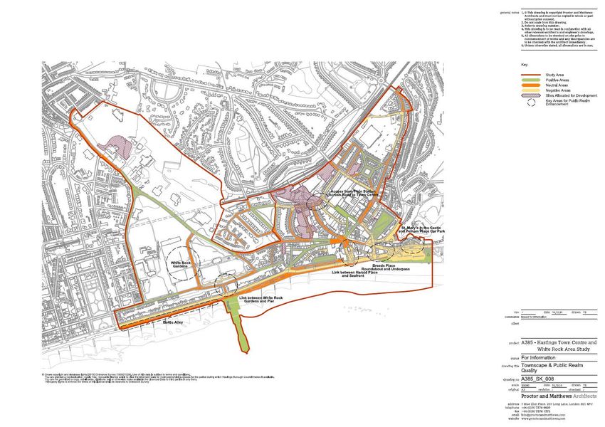
HASTINGS TOWN CENTRE AND WHITE ROCK STUDY: FINAL REPORT

SECTION 2: THE CONTEXT

                         7                                                gva.co.uk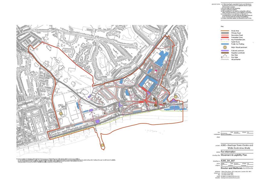
HASTINGS TOWN CENTRE AND WHITE ROCK STUDY: FINAL REPORT

2 THE CONTEXT FOR THE STUDY                                                                              2.1.1 THE STUDY AREA: HASTINGS TOWN CENTRE AND
                                                                                                               WHITE ROCK AREA
2.1 GEOGRAPHICAL CONTEXT                                                                                 As shown in figure 3, the study area falls under the sub-areas Central St. Leonards & Bohemia,
                                                                                                         and Hasting Town Centre as defined by the Hastings Planning Strategy (2014).
The Borough of Hastings is located along the South coast, between Eastbourne and Folkestone.
Hastings is a mainly urban community of approximately 90,000 people, and together with Bexhill,          Both sub-areas have their own distinctive identity. Hastings Town Centre is the Town’s prime retail
a smaller settlement to its west, forms a population of around 135,000.                                  centre and includes a significant stretch of the seafront, the Victorian Pier, and seaside activities.

The town has 8 miles of coastline and is surrounded by the mainly rural district of Rother,              The study area (figure 4) also comprises White Rock Gardens. The White rock Gardens provide
bordered by the High Weald to the north, Combe Haven Valley to the west and Fairlight to the             excellent views to the seafront and contain a number of leisure attractions and opportunities.
east. Its development has thus been shaped by its relationship to the sea, its distance from
London (60 miles) and the physical constraints of its geography.
                                                                                                         FIGURE 3: HASTINGS CENTRAL AREA
Although Hastings is connected to the strategic road network by the A259 and A21, it continues
to suffer from poor transport connections compared with the rest of the region. High Speed One
(HS1) and trunk road improvements elsewhere, has left Hastings relatively isolated. Despite this,
the town has four railway stations with regular services to London, Brighton and Ashford (Hastings
Planning Strategy, 2011-2028).

FIGURE 2: HASTINGS CONTEXT

                                                                                                         Hastings Planning Strategy (2014)

                                                                                                                                  Central St. Leonards   Hastings Town Centre
                                                                                                                                  & Bohemia

Source: ONS

                                                                                                     8                                                                                          gva.co.uk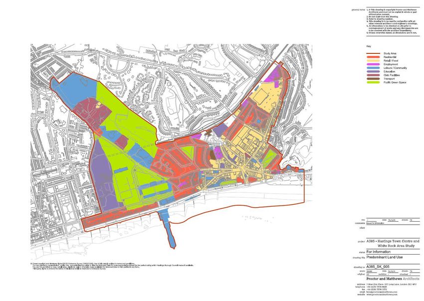
HASTINGS TOWN CENTRE AND WHITE ROCK STUDY: FINAL REPORT

FIGURE 4: STUDY AREA BOUNDARY

                                                          2.2 STRATEGIC CONTEXT- ISSUES AND PRIORITIES
                                                          This report is intended to provide a key evidence base for the Council’s production of an Area
                                                          Action Plan for the Town Centre and White Rock. The study area is considered to provide
                                                          considerable opportunity for regeneration and redevelopment to bring enhanced benefits for
                                                          Hastings and to address a number of the key issues already identified in the Council’s Local Plan
                                                          (Hastings Planning Strategy (adopted 2014) and Hastings Development Management Plan
                                                          (adopted 2015). The following section highlights the key issues and priorities for Hastings as
                                                          identified in the adopted Planning Strategy (2014):

                                                          Retail and Hastings Town Centre: Hastings Town Centre underwent a major planned
                                                          improvement and expansion during the 1990s with construction of the Priory Meadow Shopping
                                                          Centre and pedestrianisation of the main shopping streets. This enabled it to fulfil its natural role
                                                          as a sub-regional centre. Its catchment area takes in Hastings and St Leonards, parts of Bexhill
                                                          and the more rural communities to the north and east of Hastings.

                                                          However, Hastings currently faces competition from neighboring centres at Eastbourne,
                                                          Tunbridge Wells and Ashford. It is important the vitality and viability of retail areas in Hastings,
                                                          including Hastings Town Centre are safeguarded and enhanced. Failure to plan for future retail
                                                          needs will mean that these competing centres will begin to absorb the share of the spending
                                                          that Hastings currently attracts. This would lead to decline of the centre and maybe an inability
                                                          for it to serve even the needs of Hastings residents.

                                                          Cultural regeneration: Hastings has a strong and diverse cultural infrastructure including a
                                                          number of important components – most recently, the Jerwood Gallery and Stade performance
                                                          space but also: performance venues, museums; art galleries and studios; the cultural dimension
                                                          offered by Sussex Coast College and the University of Brighton Hastings campus; and most
                                                          importantly, its artists, performers and other creative businesses and communities. The Council
                                                          and its partners have recently focused heavily on culture as an instrument of social change and
                                Extended study area
                                                          economic growth. The arrival of the Jerwood Gallery and Stade open space in 2012 marked a
                                                          significant point on this journey. The Gallery has had a major positive impact itself, and
                                                          subsequently the potential of culturally based regeneration to deliver change has become
                                                          much more widely accepted.

                                                          The demand for affordable housing exceeds supply in Hastings: Hastings residential values have
                                                          consistently remained below the average for the South East. This is due to a range of factors
                                                          including the mix of housing. However, the affordability of housing is about the relationship
                                                          between income and house prices. In Hastings, this ratio is on a par with many areas in the South
                                                          East because of the low wage economy. As a consequence rising house prices means that
                                                          housing has become less affordable for local people. Given the constraints to development,
                                                          the Hastings Planning Strategy, which provides for at least 3,400 net new homes by 2028 goes as
                                                          far as it is able in meeting housing need particularly affordable housing. Objectively assessed
                                                          housing need indicates housing demand up to 2028 to be approximately double this amount.

                                                      9                                                                                          gva.co.uk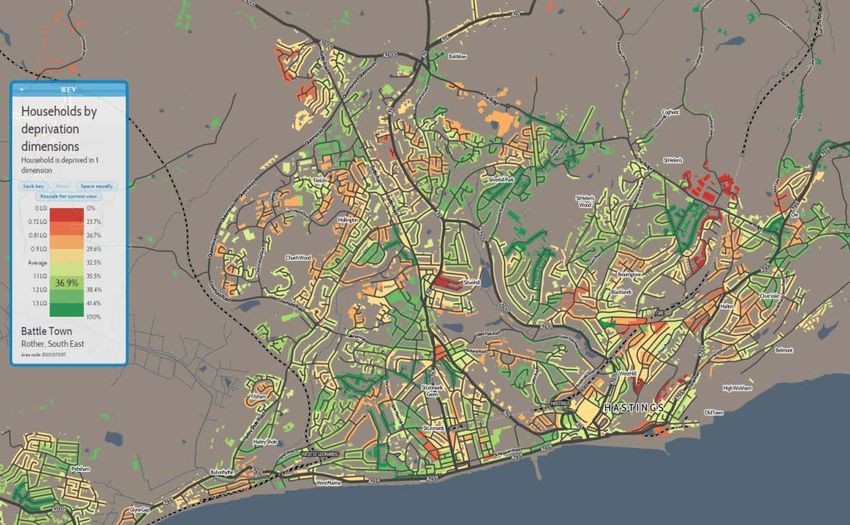
HASTINGS TOWN CENTRE AND WHITE ROCK STUDY: FINAL REPORT

Limited space for growth and development: There are limits to the amount of land available for
                                                                                                        FIGURE 5: WIDER TRANSPORT NETWORK-HASTINGS
development and regeneration purposes within the town and outward expansion is constrained
by protected landscape and countryside such as the Hastings Country Park and the High Weald
Area of Outstanding Natural Beauty (AONB).

Retaining the Character: Hastings is known for its seaside location, wooded valleys, varied wildlife
and surrounding countryside, with distinctive conservation areas and attractive Victorian housing
stock, all contributing to the special character of Hastings. The main challenge for the borough is
to conserve and enhance the best of this and at the same time enable high quality
development to meet future needs.

Transport links: There are two main connections into Hastings, A21- the primary access to London
and the A259 which runs along the coast to Brighton in the west and Ashford to the east. There is
choice of train service connections between Hastings and London including High Speed one to
St Pancras via Ashford. However, despite the choices, the journey times are slow. For example,
the route to London (Charing Cross), only 60 miles away, takes over 90 minutes.

The local business community in Hastings prioritised the need for improvements to the A21 and
A259, and the rail links to London and Ashford as being vital to making Hastings a more
attractive place for businesses to locate in and to operate from.

The opening of the Bexhill - Hastings Link Road in December 2015 marked the successful
completion of a joint long-term objective. The road will support the delivery of 1200-2000 new
homes and the provision of a 50,000 sq.m of business park and regeneration amounting to £1
billion over 25 years.
                                                                                                         Transport Priorities

2.2.1 PRIORITIES                                                                                         Wider improvements to          Improve connectivity along the coast towards the A23/ M23
                                                                                                         the A21 and A259 corridor      and Gatwick Airport.
Jobs and Homes: The Hastings Planning Strategy (2014) will deliver at least 3,400 new homes and
up to 70,000 sq.m. of employment space. The Council has confirmed that the adopted Planning
Strategy housing target of 3,400 homes, falls somewhat short of the identified housing needs and
                                                                                                         Ashford to Hastings line –     Electrification of the Hastings to Ashford line to enable high
that, where they exist, opportunities should be taken to address how this need can be met;
                                                                                                         capacity and journey time      speed services to run to Hastings and Bexhill. This could bring
potentially through opportunities identified in this study.
                                                                                                         improvements                   journey times down from 90-100 minutes from Hastings to St
                                                                                                                                        Pancras via Ashford to around 68 minutes.
Accessibility and Connections: Hastings has relatively poor accessibility and transport
connections compared to surrounding towns within the South East and longer journey times to
London and regional centres such as Gatwick, Ashford and Brighton. Transport priorities for the
borough are identified in the Planning Strategy.                                                         Hastings to Tonbridge line     Journey time improvements on the Hastings to Tonbridge Line.
                                                                                                         capacity and power
                                                                                                         supply improvements

                                                                                                        Source: Hastings Planning Strategy (2014)

                                                                                                   10                                                                                       gva.co.uk
HASTINGS TOWN CENTRE AND WHITE ROCK STUDY: FINAL REPORT
Context for Positive Change: Hastings is undergoing significant change with several regeneration
initiatives/projects currently being planned and undertaken. The study area in particular has a
significant amount of regeneration funding which has been focused in the Town Centre in
recognition of its importance, particularly in terms of improving the education offer at the 2.3 SOCIO-ECONOMIC CONTEXT
University of Brighton Hastings Campus and the Sussex Coast College.
In addition, new office and retail developments at Priory Quarter are likely to ensure the quality
2.3.1 POPULATION STRUCTURE
of space available is improved, and contribute positively to the local economy. The 2011 Census recorded that Hastings borough has a population of 90,300. In 2001 Hastings
had a population of 85,400, which represents a 5.7% increase over 10 years. Hastings is the 9th
The following provides a brief overview of particular developments planned/ undertaken in the smallest local authority within the South East.
area.
FIGURE 6: POPULATION ESTIMATES BY AGE STRUCTURE FOR HASTINGS IN 2011 AND 2028
• The Jerwood Gallery and a booming Old Town area (at the eastern end of the
Promenade) are important to the heritage and historical importance of the town and are
successful examples of cultural regeneration. The area has seen rising interest, and
investment activity.
• Clear signs of successful regeneration are present throughout Hastings and St Leonards.
• University campus buildings have provided impetus and an important opportunity for
Hastings to grow its reputation as a centre of excellence for higher education. In light of
recent announcements by the University, the retention of such in some revised form will be
a key element in raising local aspiration and opportunity.
• New employment space are opening up, both formal and informal. The creative industries,
in particular, are slowly becoming established within the town, offering a new and more
diverse economic and employment base. New employment allocations are set out in the
Development Management Plan, including the Town Centre and land at Queensway
which is part of the wider Enviro21 employment corridor.
• Restoration of the Town’s Victorian Pier due to open with considerable support from the
local community.
• Prior Quarter now phase III following the successful completion of 2 earlier phases.
• Hastings and Bexhill Seafront Strategy Refresh (2014-2020) identified several short-term and
long-term proposals along the seafront many of which have advanced in terms of funding
and construction on the ground. Seafront projects like Hastings Pier regenerations and new
BMX and Skate Park at the former White Rock Baths.
11 gva.co.ukHASTINGS TOWN CENTRE AND WHITE ROCK STUDY: FINAL REPORT
Population and Household Forecast: Based on the housing growth proposed between 2011 and FIGURE 7: ECONOMIC ACTIVITY
2028, the population is forecast to grow by 3.2%. At the same, time growth in the number of
households is expected to increase from 41,000 in 2011 to 44,500 in 2028 (an increase of 8.2%).
The working age population is forecast to remain static between 2011 and 2028.
Economic Activity and Employment: Table 1 shows that Hastings has relatively low economic
activity (76.1%) compared to the regional (80.1%) and national average (77.5%). Unemployment
in Hastings is also higher (8.4%) compared to the region (4.4%) and nationally (5.7%).
TABLE 1: EMPLOYMENT AND UNEMPLOYMENT (JUL 2014-JUN 2015)
Hastings Hastings South Great
East Britain
(Numbers) (%) (%) (%)
Source: Datashine
All People
Economically Active† 45,200 76.1 80.1 77.5
In Employment† 40,600 68.6 76.4 73.1
Employees† 34,800 59.6 64.4 62.5
Self Employed† 5,800 9 11.7 10.1
Unemployed (Model-Based) 3,700 8.4 4.4 5.7
Source: ONS Source: Datashine (2015)
The high unemployment count in Hastings is also reflected in the numbers of Job Seeker
Figure 7 shows the economic activity of full-time employees. Higher economic activity by Allowance (JSA) claimants in the borough which is significantly high at 2.1% compared to the
residence is located towards the outskirts of Hastings whilst there is lower economic activity within regional (0.9%) and national average (1.5%).
the Town Centre and the seafront area.
TABLE 2: TOTAL JSA CLAIMANTS (JAN 2015)
Hastings Hastings South Great
East Britain
(Numbers) (%) (%) (%)
All People 1,208 2.1 0.9 1.5
Source: ONS
12 gva.co.ukHASTINGS TOWN CENTRE AND WHITE ROCK STUDY: FINAL REPORT
FIGURE 9: DEPRIVATION AT REGIONAL LEVEL
2.3.2 DEPRIVATION LEVELS
Along with other coastal areas in the UK, Hastings has suffered from challenging economic times.
This has in part been caused by changes in holiday patterns and destination and has led to a
service sector centred economy.
The Government’s Indices of Multiple Deprivation (IMD, 2015) ranks Hastings as the 20th most
deprived area in England (out of 326).
FIGURE 8: HOUSEHOLDS BY DEPRIVATION
Source: Data from Open Data Communities: 2015 Deprivation Mapper
Source: Datashine In response to this the Council has prioritised a multi-agency approach to addressing the causes
S D t hi
of deprivation which can result in low skills, poor educational attainment, ill health, poverty, lack
of job opportunities, poor housing quality and high crime rates (Hastings Planning Strategy, 2014).
2.3.3 HEALTH
The following maps show the state of general health in Hastings.
Source: Datashine(2015) The study area performs poorly in terms of health statistic with most of the area falling below
average.
Figure 8 shows high deprivation levels in the borough (with most areas deprived by at least one
or more dimension). Generally, this is evenly throughout the Borough.
The map shows that the Town Centre and the White Rock Area is performing higher than the
Borough average.
13 gva.co.ukHASTINGS TOWN CENTRE AND WHITE ROCK STUDY: FINAL REPORT
FIGURE 10: DISTRIBUTION OF THE HASTINGS POPULATION IN ‘VERY GOOD HEALTH’ FIGURE 11: DISTRIBUTION OF THE HASTINGS POPULATION IN ‘VERY BAD HEALTH’
Source:
Source: Datashine
Datashine
Source: Datashine (2015)
Source: Datashine (2015)
14 gva.co.ukHASTINGS TOWN CENTRE AND WHITE ROCK STUDY: FINAL REPORT
FIGURE 12: NO QUALIFICATIONS
2.3.4 EDUCATION
Table 3 shows the skills profile of Hastings residents. It shows that the population has generally low
qualifications compared to the regional and national average. At the high skill levels Hastings
residents have 34.3% qualifications to level 4 or above, compared to 39.1% in the South East
region.
TABLE 3: QUALIFICATIONS (JAN 2014-DEC 2014)
Hastings Hastings South East Great Britain
(Level) (%) (%) (%)
NVQ4 And Above 19,600 34.3 39.1 36
Source:
Datashine
NVQ3 And Above 31,000 54.2 60.5 56.7
NVQ2 And Above 39,000 68.1 77.1 73.3
NVQ1 And Above 47,900 83.8 89.2 85
Other Qualifications 3,900 6.8 5.2 6.2
No Qualifications 5,400 9.4 5.6 8.8
Source: ONS
Figure 12 shows the distribution of resident population with no recognised qualifications, which
adversely affects their ability to compete for jobs. The need for skills development has been Source: Datashine (2015)
recognised within sub-regional and Local Plan policies and a number of initiatives are underway
(the University Centre Hastings has been expanded, having opened a second building in Priory
Square in 2012) with specific objectives to increase higher level qualifications within the
workforce.
15 gva.co.ukHASTINGS TOWN CENTRE AND WHITE ROCK STUDY: FINAL REPORT
TABLE 5: EMPLOYMENT BY OCCUPATION (JUL 2014-JUN 2015)
2.3.5 ECONOMIC SECTORS AND EMPLOYMENT PROFILE
Table 4 shows employment by broad sectors in Hastings. The public sector is the biggest Hastings Hastings South East Great Britain
employer in Hastings and among this, the Health sector employs over 23% of residents.
(Numbers) (%) (%) (%)
The table indicates that there is high employment in Hastings in the health and retail sectors (36%
combined). Other key employment sectors in Hastings include education, accommodation & Standard Industrial Classification 16,900 41.5 49.4 44.3
food services, manufacturing, and public administration and defence, each having a proportion 2010 Major Group 1-3
of employees between 7% to 9%. In comparison, high value sectors like professional and 1 Managers, Directors And Senior 6,700 16.4 11.8 10.3
technical services, finance and insurance and ICT each have low representation (HASTINGS TOWN CENTRE AND WHITE ROCK STUDY: FINAL REPORT
FIGURE 14: TRAVEL TO WORK COMMUTING PATTERN, HASTINGS (2011)
2.3.6 TRAVEL TO WORK AND COMMUTING PATTERNS
Travel to Work Areas (TTWAs) are officially recognised “labour market areas”, defined by the
Office for National Statistics (ONS). They are areas in which the bulk (at least 75%) of the resident
economically active population also work.
Based on the 2011 TTWA map (ONS) shown in figure 13, Hastings Travel to Work Area embraces
most of Rother (over 90% of its population) and is bordered by Eastbourne, Tunbridge Wells and
Ashford TTWAs.
FIGURE 13: HASTINGS TTWA MAP, 2011
FIGURE 15: TRAVEL TO WORK PATTERN, HASTINGS (2011)
Figure 14 shows commuting patterns i.e. inflow and outflow of the population in Hastings for
work. It shows that Hastings has strongest relationship with Rother with a significantly high
proportion of Rother residents commuting into Hastings for work and similarly, a significant
number from Hastings commuting into Rother for work.
Travel
Out
17 gva.co.ukHASTINGS TOWN CENTRE AND WHITE ROCK STUDY: FINAL REPORT
2.3.7 SUMMARY:
Hastings is growing: Based on housing-led growth Hastings is expected to grow by at least 3.2% in
population and the number of households is expected to increase from 41,000 in 2011 to 44,500
2.4 HASTINGS MARKET COMMENTARY
in 2028.
2.4.1 HOUSING MARKET
Low economic activity and employment: Hastings has relatively low economic activity and a
high unemployment rate compared to the regional and national average. The Local Plan seeks Hastings falls within the wider Hastings and Rother sub-region and is one of the smallest functional
to address this through allocations for employment and retail growth. housing markets in the South East of England.
High deprivation and poor health: According to the Government’s Indices of Multiple The area of Hastings Borough and Rother District operates largely as a single housing and labour
Deprivation (IMD, 2015) Hastings is the 20th most deprived area in England (out of 326). market, though the northern parts of Rother District look more to Tunbridge Wells than to
Hastings. The sub-region is characterised by considerable internal diversity (Hasting and Rother
High public sector employment and less employment in high-value economic sectors: A Housing Market Assessment, 2006).
significantly high proportion of the Hastings’ residents are employed in the public sector,
specifically in the health sector. There is less employment in technical and professional FIGURE 16: HASTINGS AND ROTHER HOUSING MARKET
occupations within the Borough.
Source: Hasting and Rother Housing Market Assessment, 2006
2.4.1.1 RESIDENTIAL VALUES AND OTHER CHARACTERISTICS
RENTAL VALUES
The Zoopla heat map in figure 17 suggests house prices are lower in Hastings than in the
surrounding area. The rural parts of Rother have much higher house prices than Hastings or
Bexhill. According to Zoopla the current average asking price in Hastings is c.£210,000,
compared to £410,000 in nearby Battle. Prices in the rural areas tend to be higher still.
18 gva.co.ukHASTINGS TOWN CENTRE AND WHITE ROCK STUDY: FINAL REPORT
FIGURE 18: MEDIAN HOUSE PRICES (£)
FIGURE 17: RESIDENTIAL VALUE HEAT MAP
Source: Land Registry
FIGURE 19: AVERAGE CURRENT VALUE (2015)
Source: Zoopla
Figure 18 shows the average house price trend in Hastings compared to neighbouring local
authorities and the wider region. Values in Hastings are relatively lower than the wider East Sussex
and the South East. However, the house prices have been consistently increasing in the area
since 2009,
Source: Zoopla
19 gva.co.ukHASTINGS TOWN CENTRE AND WHITE ROCK STUDY: FINAL REPORT
Residential values in Hastings have seen a steep increase by 10% over the last 12 months, and AFFORDABILITY
22.5% over the last five years.
FIGURE 20: VALUE TRENDS IN HASTINGS Figure 22 shows the affordability ratio trends in Hastings in relation to the neighbouring local
authorities and the county from 2006 to 2013. Houses in Hastings are generally more affordable
than in Rother or East Sussex.
FIGURE 22: AFFORDABLITY, RATIO OF MEDIAN HOUSE PRICE TO MEDIAN EARNINGS
FIGURE 21: VALUE CHANGE (2010-2015)
Source: DCLG
Figure 23 shows the increase in the dwelling stock by base year in Hastings between 2009 and
2014 compared to neighbouring authorities and East Sussex.
FIGURE 23: DWELLING STOCK ESTIMATE BY LOCAL AUTHORITY
Source: Zoopla
Source: DCLG
20 gva.co.ukHASTINGS TOWN CENTRE AND WHITE ROCK STUDY: FINAL REPORT
TABLE 6: TOTAL DWELLING STOCK OWNERSHIP
2009 2010 2011 2012 2013 2014 According to the Housing Market Assessment (2006), the majority of householders in Hastings are
owner-occupiers; however, the level of ownership has significantly fallen since 1991 when it was
East Sussex 75%. The sub-region has experienced a 50% growth in the private rented sector.
240,100 241,520 243,260 244,880 246,180 247,400
Eastbourne In terms of tenure, Figure 25 shows tenure split by major group for Hastings in 2011. It shows that
46,980 47,270 47,470 47,690 47,850 48,090
most housing in Hastings is under private sector ownership (c. 78%).
Hastings
42,350 42,590 42,770 43,130 43,280 43,430
FIGURE 25: NUMBER OF DWELLINGS BY TENURE, 2011
Rother
43,600 43,750 44,020 44,190 44,290 44,450
Source: DCLG
DWELLING SIZES
Hastings and Rother Housing Market Assessment (2006) confirms that around 37% of dwellings in
the sub-region have less than 5 rooms, compared to 30% of dwellings in the South East of
England. Smaller dwellings are particularly concentrated in Hastings, where 40% of dwellings
have less than 4 rooms, and there is a correspondingly small proportion of larger dwellings with 7
or more rooms. Hastings in particular has a relative concentration of flats and has a
correspondingly high incidence of overcrowding. Almost 10% of households in Hastings live in
overcrowded conditions. The Local Plan is seeking to re-balance the housing stock through the
provision of more family and larger sized dwellings.
Source: DCLG
FIGURE 24: DWELLING SIZES, 2007
21 gva.co.ukHASTINGS TOWN CENTRE AND WHITE ROCK STUDY: FINAL REPORT
Average office rents 3 for the last five years in Hastings Town Centre are £13.74/ sq.ft which is
2.4.2 OFFICE MARKET slightly higher than the borough’s average of £10.69/ sq.ft (CoStar). In general, the rental values
Figure 26 shows the distribution of office stock in Hastings. The majority of office floorspace is in Hastings have been lower than the wider East Sussex where the average five year rental
concentrated in Hastings Town Centre. values have been around £14.88/ sq.ft.
FIGURE 26: DISTRIBUTION OF OFFICE UNITS IN HASTINGS FIGURE 27: OFFICE RENTAL VALUES, £/ SQ.FT (5 YEAR AVERAGE, 2010-2015)
Source: CoStar
Source: CoStar Suite
There are a significant number of office units in Hastings, providing c.600,000 sq.ft of office space.
Hastings Town Centre provides approximately 65% of the total office floorspace.
3 These refer to asking rents. Asking rental rates are defined as the annual costs of occupancy for a particular
space that is available for lease that is being asked for by the owner of the building, quoted on a per square
foot basis. Asking rental rates may differ from the actual (achieved) rates paid by tenants following the
negotiation of all terms and conditions in a specific lease.
22 gva.co.ukHASTINGS TOWN CENTRE AND WHITE ROCK STUDY: FINAL REPORT
Figure 28 shows the five-year asking rents trend in Hastings Town Centre. It shows an increase in FIGURE 29: VACANCY AND AVAILABILITY RATES- OFFICE MARKET
the rental trends in the Town Centre in 2012/13 where the rental values increased significantly
and have shown a steady upward trend since then.
FIGURE 28: ASKING RENTS-OFFICE MARKET, HASTINGS TOWN CENTRE AND WHITE ROCK (SQ.FT)
Source: CoStar
Source: CoStar
Figure 29 shows the vacancy 4 and availability rate 5 for Hastings Town Centre against the wider
context. Vacancy rates are slightly higher in the Town Centre 5.6% compared to the borough
and East Sussex average. Availability rates on the other hand are lowest in the Town Centre
(7.5%) compared to the borough (11.7%) and East Sussex average (9%)
4Vacancy Rate: Expressed as a percentage - it identifies the amount of New/Relet/Sublet space that is
vacant divided by the existing Rentable Building Area. Can be used for buildings or markets. (CoStar)
5 Availability Rate: Expressed as percentage. It is the total amount of space that is currently being marketed as
available for lease or sale in a given time period. It includes any space that is available, regardless of whether
the space is vacant, occupied, available for sublease, or available at a future date. (CoStar)
23 gva.co.ukHASTINGS TOWN CENTRE AND WHITE ROCK STUDY: FINAL REPORT
Figure 30 shows average vacancy and availability rate trends between 2011 and 2015. It shows
that vacancy rates in the Town Centre are currently 4.9%. Vacancy rates peaked in 2011 at just 2.4.3 RETAIL MARKET
over 7% and decreased steadily since this point. Figure 31shows the distribution of retail stock in Hastings. There are three major clusters of retail
floorspace concentrated throughout Hastings, the largest of these being Hastings Town Centre.
Availability peaked in 2013, before falling over the next year to 10%. In the last quarter the
availability rate has marginally increased to just below 11% of stock. FIGURE 31: DISTRIBUTION OF RETAIL UNITS IN HASTINGS
FIGURE 30: AVAILABILITY AND VACANCY RATE TRENDS, HASTINGS TOWN CENTRE AND WHITE ROCK
Source: CoStar Source: CoStar Suite
24 gva.co.ukHASTINGS TOWN CENTRE AND WHITE ROCK STUDY: FINAL REPORT
Table 7 shows the existing or current floorspace for retail use in the study area in relation to the Hastings as a centre for retail for businesses or may be a result of completion from neighbouring
wider area. There are over 200 retail units in Hastings providing c. 1,189,083 sq.ft of retail space. shopping centres.
Approximately 50% of this floorspace is within the Hastings Town Centre.
FIGURE 33: ASKING RENTS-RETAIL MARKET, HASTINGS TOWN CENTRE AND WHITE ROCK AREA
TABLE 7: EXISTING BUILDINGS AND FLOORSPACE FOR RETAIL (SQ.FT)
Availability (5- Hastings Town Centre
year average) and White Rock Hastings East Sussex
Existing Buildings 97 226 3,561
Existing Sq Ft 6 577,465 1,189,083 13,058,583
Figure 32 shows the 5-year average rental values in the study area for the 2010-2015 period. It
shows that the average rental value in the study area (£25.69) is higher than the wider Borough’s
(£18.82) average and slightly higher than East Sussex (£24.51).
FIGURE 32: AVERAGE 5-YEAR RETAIL VALUES (SQ.FT)
Figure 35 shows the vacancy 7 and availability rate 8 for Hastings Town Centre against the wider
context. Hastings vacancy rates are more or less in line with the Town Centre (1.3%). Availability
rates are much higher in the Town Centre (4%) and Hastings (4.4%) compared to the wider East
Sussex averages (2.8%)
Figure 33 shows the five-year retail rental trend for the study area. The most recent retail rents in
2015 in Hastings Town Centre and White Rock area are £27 per sq.ft. Figure 34 shows that there
was a rapid increase in rental values throughout 2012, reaching a peak at the start of 2013. Since
then, rents have gradually decreased in value. This could reflect the declining attractiveness of
7Vacancy Rate: Expressed as a percentage - it identifies the amount of New/Relet/Sublet space that is
vacant divided by the existing Rentable Building Area. Can be used for buildings or markets. (CoStar)
6The current floorspace which exists, regardless of availability, size, state of repair and any other
characteristics.
8 Availability Rate: Expressed as percentage. It is the total amount of space that is currently being marketed as
available for lease or sale in a given time period. It includes any space that is available, regardless of whether
the space is vacant, occupied, available for sublease, or available at a future date. (CoStar)
25 gva.co.ukHASTINGS TOWN CENTRE AND WHITE ROCK STUDY: FINAL REPORT
FIGURE 34: AVAILABITY AND VACANCY RATE
2.4.4 SUMMARY
Housing Market:
The study property market assessment provides a range of findings that presents a wider market
context for the area. In particular the residential market has the following key features:
• Comparatively low, but rising, house prices: Housing value trends in Hastings are
generally lower than the wider East Sussex area and the South East region. However,
house prices have shown a steady increase in Hastings since 2009.
• Declining affordability: Houses in Hastings are generally more affordable than in Rother
or East Sussex County. However, the affordability in Hastings has been declining in the
last three years.
• Increasing housing stock and bias towards smaller dwellings: The assessment shows
that Hastings has seen a significant increase in housing stock compared to Rother and
Eastbourne local authorities. Dwelling sizes in Hastings are relatively smaller compared
to the wider housing market area and the Borough has a relatively high concentration
of flats.
• Growth in the private rented sector: The majority of householders in Hastings are owners
occupiers, but the level of ownership has significantly fallen since 1991. The sub-region
Figure 35 shows availability and vacancy trends in the study area between 2011 and 2015. has experienced a 50% growth in the private rented sector
Vacancy rates in the Town Centre are currently at 1.6%, which is below the five year average of
1.9%. Vacancy rates peaked in mid-2012 and have been gradually declining ever since. Office and Retail Market:
The current availability rate for retail provision is 4.7%. The availability rates have fluctuated Town Centre, a significant contributor: Hastings Town Centre presents a significant opportunity to
significantly throughout the previous 5 years, peaking in 2013 at over 7.5%. The 5 year average the borough in terms of office and retail stock. c.65% of the office floorspace and c.50% of the
availability rate is 5.8%, slightly higher than the present day rate. retail floorspace in the borough is located in the Town Centre.
FIGURE 35: AVAILABILITY AND VACANCY RATE TRENDS, HASTINGS TOWN CETNRE AND WHITE ROCK Strong values indicating strong demand: The rental values in the Town Centre for office and retail
properties are generally in line with the wider East Sussex trends. Retail rental values in the Town
Centre are much higher than the Borough average indicative of a strong demand in the Town
Centre.
Within this study we go on to analyse from an urban design and development opportunity
perspective, those areas within the study which we believe offer a significant opportunity to
capitalise on and grow the strengths of both the Town Centre, the cultural and leisure identified
in section 3 of this report and of meeting some of the opportunities that mixed development will
bring to the delivery of these objectives.
26 gva.co.ukHASTINGS TOWN CENTRE AND WHITE ROCK STUDY: FINAL REPORT
SECTION 3: URBAN DESIGN
ANALYSIS & OPPORTUNITIES
27 gva.co.ukHASTINGS TOWN CENTRE AND WHITE ROCK STUDY: FINAL REPORT
3 URBAN DESIGN ANALYSIS
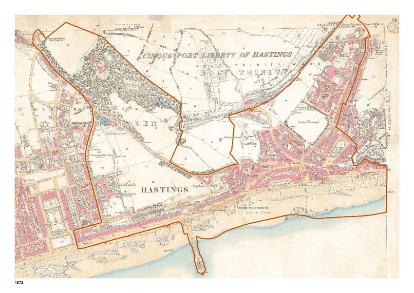
FIGURE 36: MAP OF 1873
3.1 INTRODUCTION AND METHODOLOGY
An urban design analysis was carried out to contribute to the evidence base of the Hastings
Town Centre and White Rock Study to inform the identification of development and investment
opportunities. The urban design analysis considered the historic development of the study area
to its present day form, context within the wider town, topography, land use, Character Areas,
landscape and heritage, movement and legibility, townscape and public realm quality. The
audit was carried out in three parts:
1. A desktop analysis of the physical characteristics of the study area based on historical and
current maps, topographical data and other information regarding for example, specific
sites.
2. A rapid but comprehensive urban design assessment carried out on a site walkabout.
3. Stakeholder workshop input, checking and supplementing the initial analysis and
highlighting key issues and ideas.
The following sections outline the key findings of the analysis.
3.2 HISTORIC DEVELOPMENT TO PRESENT FORM
The following sets out the key historic developments of the study area, which provide the
structure of the area today.
Pre-19th Century
• The study area covers the valley of the Priory Stream which flowed into the sea at “The
Haven”. The Priory Stream has long since been culverted under Queens Road.
• Medieval Priory of the Holy Trinity located in the vicinity of Cambridge Road
• Expansion of the town’s population in late 18th Century to meet demand as a fashionable
seaside resort.
28 gva.co.ukHASTINGS TOWN CENTRE AND WHITE ROCK STUDY: FINAL REPORT
19th Century FIGURE 37: MAP OF 1899
• The Old Town spread west into Priory valley in the 1820s with the cutting back of castle cliff
to create access for development at Castle Street in 1818.
• Wellington Square and Pelham Crescent were earliest developments in the 1820s.
• Informal settlement to the west of the valley on an area known as the America Ground
cleared in the 1830’s to make way for development of Robertson Street, Trinity Street and
Carlisle Parade.
• Town expanded further with arrival of the railway in the 1850s.
• Pugin-designed Grade II* listed former Holy Child Convent chapel complete by 1869.
• Large proportion of the current Town Centre in place by the 1870s including the Pier
• Main route through the town from the seafront was along Robertson Street and Castle
Street via Harold Place.
• The Albert Memorial (removed in the 1970s) marked the original centre of town at the
junction of Robertson Street, Havelock Place and Harold Place.
• County cricket ground on the site of the current Priory Meadow Shopping Centre
• Gas works on the current site of Morrisons
• White Rock Gardens and Summerfields was open space and included the wooded private
estate of Bohemia House and Farm.
29 gva.co.ukHASTINGS TOWN CENTRE AND WHITE ROCK STUDY: FINAL REPORT
20th Century
• Town Centre expanded north to the railway line and beyond.
• White Rock Grounds laid out on land acquired by the Council in the early 1900s including
ornamental features as well as pavilions and sports facilities for tennis, putting and bowling.
• By 1938 the seafront road was transformed by Borough engineer, Sidney Little, to become
the main through route with new concrete sea wall and promenade with underground car
park at Carlisle Parade, now a listed heritage asset, and the art deco style White Rock
Baths.
• String of civic facilities developed in 1970s and 80s along Bohemia Road including the
police station, fire station, ambulance station and leisure centre.
• Development of Priory Meadow Shopping Centre over the old cricket ground and
associated pedestrianisation of Town Centre streets in early 1990s.
• Relocation of cricket ground to current site at Horntye.
• Other key sites redeveloped include tower blocks Cavendish House and Aquila House on
the seafront at Breeds Place and the Morrisons supermarket on the site of the former gas
works.
3.2.1 SUMMARY
• Town defined to a large extent by its heritage being associated nationally and
internationally with the 1066 Norman Conquest of England.
• Hastings expanded from a small fishing port in the medieval period contained within the
Bourne river valley to a seaside resort with elegant Georgian and Victorian terraces and
crescents spanning the adjacent Priory Valley.
• Buildings from the 19th Century dominate the townscape of the Town Centre Grade I Listed
Hastings Castle on top of West Hill is a strong visual and historic landmark.
• White Rock Gardens is an example of early 20th Century municipal park design with much
of the original structure remaining today.
• Summerfields area includes remains of the Bohemia House estate.
• Seafront promenade structures from 1930s are legacy of Sidney Little, Borough engineer.
• Development of Priory Meadow Shopping Centre displaced the cricket ground to its
current Summerfields site and moved the retail focus away from the traditional streets of the
Town Centre.
• Recent Royal Society for Arts report of national heritage put Hastings in the top 5% of
England’s local authorities.
30 gva.co.ukHASTINGS TOWN CENTRE AND WHITE ROCK STUDY: FINAL REPORT
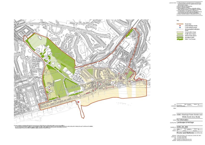
FIGURE 38: THE STUDY AREA AND KEY OPPORTUNITIES
31 gva.co.ukFIGURE 39: TOPOGRAPHY HASTINGS TOWN CENTRE AND WHITE ROCK STUDY: FINAL REPORT
32 gva.co.ukHASTINGS TOWN CENTRE AND WHITE ROCK STUDY: FINAL REPORT
3.3 TOPOGRAPHY AND LANDSCAPE CONTEXT
• Hastings Town Centre located between Hastings Old Town to the east and St Leonards-
on-Sea to the west with the railway line forming the northern boundary.
• Seafront forms the town’s southern boundary and provides a natural edge.
• Town sits on sandstone eroded into ridges and wooded ghylls, providing a series of green
spaces and woodland within the urban area.
• Topography strongly influences character, legibility and movement with the town,
located in a river valley bounded by steep hills to the east and west.
• River now culverted under the Town Centre with an outlet into the sea.
• White Rock Gardens sit at a higher level and rise from between 24 metres above sea
level in the south to 54 metres above sea level in the north.
• Horntye Park Sports Centre sits at the highest point within the study area at around 74m
above sea level
33 gva.co.ukHASTINGS TOWN CENTRE AND WHITE ROCK STUDY: FINAL REPORT
FIGURE 40: LAND USE
34 gva.co.ukHASTINGS TOWN CENTRE AND WHITE ROCK STUDY: FINAL REPORT
3.4 LAND USE
• Hastings Town Centre is predominantly retail focused on Priory Meadow Shopping Centre
and nearby pedestrianised streets.
• More recently developed educational and office uses are located at Station Plaza and
Priory Quarter including university and Sussex Coast College.
• Cluster of cafés around Harold Place and Robertson Street, with many pubs and bars
open into the evening.
• Secondary retail with lower quality outlets and charity shops dominate Queens Road
running north-east from the centre along with Morrison’s supermarket and petrol station
with extensive surface level parking.
• Residential terraces flank the Town Centre to the east and west with some being used as
offices or workspaces.
• White Rock and Summerfields area is largely open space with leisure facilities and a string
of civic facilities including police station, ambulance station, fire station as well as the
Summerfields Leisure Centre and Hastings Museum and Art Gallery.
• Seafront uses are mixed with mainly residential to the west and a mix of vistor
accommodation, pubs, retail and offices to the east with a few residential blocks.
• St Mary in the Castle, the White Rock Theatre and the Pier, provide cultural focal points
along the seafront.
35 gva.co.ukHASTINGS TOWN CENTRE AND WHITE ROCK STUDY: FINAL REPORT
FIGURE 41: CHARACTER AREAS
36 gva.co.ukHASTINGS TOWN CENTRE AND WHITE ROCK STUDY: FINAL REPORT
3.5 CHARACTER AREAS
2) White Rock Gardens
Broad Character Areas were defined by their urban character, structure and predominant
uses. Each one could be further divided for a more detailed assessment. This area includes the public open space south of Bohemia Road and north of St Margarets
Road divided by Falaise Road as well as the former Convent of the Holy Child Jesus.
1) Summerfields
Strengths
This area includes the land north of Bohemia Road, including Summerfields Wood Local Nature
Reserve, Horntye Park, Summerfields Leisure Centre, Hastings Museum and Art Gallery, the
• Locally important heritage public space
police station, ambulance station, fire station and the Travelodge.
• Mix of indoor and outdoor leisure facilities including long established bowling clubs
Strengths
• Well-used skate park and youth facilities
• Distinctive tree lined road providing strong break in townscape
• Nationally important Listed historic convent buildings
• Mix of civic and leisure facilities set in mature woodland
• Landscape gap between Hastings and St Leonards
• Summerfields Wood Local Nature Reserve offers wild space close to Hastings Town Centre
• Long views out to sea
• Network of formal and informal footpaths
• Some views inland across town
• Heritage/community assets: Bohemia walled garden, Listed Victorian roman bath and
Issues
ice house
Issues • Derelict and under-used leisure facilities
• Poor quality landscape and public realm
• Under-used land with little purpose around civic facilities
• Visual impact of coach parking on Falaise Road
• Unclear/poor pedestrian access to and through woodland
• Poor pedestrian access to seafront
• Poor boundary/access to White Rock Gardens
• Area disconnected with poor access from Hastings Town Centre
37 gva.co.ukHASTINGS TOWN CENTRE AND WHITE ROCK STUDY: FINAL REPORT
3) Seafront St Leonards 4) Seafront Hastings
This area includes the seafront promenade, A259 road and terraced buildings from Warrior This area includes the seafront promenade, A259 road and terraced buildings from the Pier in
Square in the west to the Pier in the east. the west to Pelham Crescent in the east.
Strengths Strengths
• Natural beach environment and views • Natural beach environment and views
• Distinctive 4-5 storey Victorian seafront terrace • East-west cycle path – part of a national cycle route
• Two level wide seafront promenade • Pier and St Mary in the Castle provide iconic cultural landmarks
• East-west cycle path – part of a national cycle route • Wide seafront promenade with historic former White Rock Baths
• Long views to Hastings Pier and castle to east and Marina Court to west • Nationally Listed Carlisle Parade car park and shelters
Issues Issues
• Busy A259 road with limited pedestrian crossings • Busy A259 road with limited pedestrian crossings
• Poor public realm and landscape quality • Harold Place underpass is unwelcoming
• Poor condition of lower level ‘Bottle Alley’ • Poor public realm and landscape quality
• Lack of activities to draw people west from Pier • Impact of parking and highway on setting of Listed St Mary in the Castle and Pelham
Crescent
38 gva.co.ukHASTINGS TOWN CENTRE AND WHITE ROCK STUDY: FINAL REPORT
5) Town centre core 6) Town Centre edge
This a large and quite varied Character Area, which includes the Town Centre shopping areas This area includes the land between the railway line and Queens Road mostly occupied by
including Priory Meadow, the train station and adjacent education buildings as well as Morrison supermarket with the Britannia Enterprise Centre to the north and the terraced houses
surrounding residential areas at White Rock, Cambridge Gardens, Wellington Square and St and shops along Queens Road.
Andrews Square.
Strengths
Strengths
• Distinctive listed railway bridge provides strong gateway feature to Hastings Town Centre
• Priory Meadow Shopping Centre is a strong attractor
• Diversity of small scale businesses at Britannia Enterprise Centre
• Tight historic urban grain creates compact, accessible retail core
• Striking views to extensive Victorian terraces on West Hill
• Cluster of heritage buildings create strong, attractive townscape
Issues
• Good mix of cultural, education and leisure facilities – university, cinema, library, Observer
Building • Loss of cohesive urban character at Morrison’s supermarket site and dominance of car
parking
• Residential areas close to centre
• Poor quality townscape along Queens Road
Issues
• Poor quality pedestrian access under railway line and into Hastings Town Centre
• Secondary retail areas in poor condition e.g. Queens Road
• Poor pedestrian access from train station to seafront
• Mixed quality and character of streetscape
• Blank rear facades to Priory Meadow blight public realm
• Impact of busy road and poor quality buildings and underpass on setting of historic
Wellington Square and gateway to town from the east.
39 gva.co.ukFIGURE 42: LANDSCAPE AND HERITAGE
HASTINGS TOWN CENTRE AND WHITE ROCK STUDY: FINAL REPORT
40 gva.co.ukHASTINGS TOWN CENTRE AND WHITE ROCK STUDY: FINAL REPORT
3.6 LANDSCAPE AND HERITAGE
See figure 42
Strengths
• Cluster of historic buildings and 19th Century street pattern in Hastings Town Centre
provide distinctive urban character
• Positive temporary cultural use of Observer Building
• Restored Pier and new use for the former White Rock Baths will provide renewed focus for
the White Rock area
• White Rock Gardens and Summerfields Woods are multifunctional public green spaces
with heritage, biodiversity and recreational value
• Beach and seashore is town’s primary natural asset
Issues
• White Rock Gardens poorly maintained and underused
• Poor access to and through Summerfields Wood
• Some historic buildings and townscape in poor condition
• Poor quality setting of key heritage assets such as St Mary in the Castle
• Limited activity and uses on seafront
• Lack of trees and greening in urban core
• Lack of heritage interpretation
41 gva.co.ukFIGURE 43: MOVEMENT AND LEGIBILITY HASTINGS TOWN CENTRE AND WHITE ROCK STUDY: FINAL REPORT
42 gva.co.ukHASTINGS TOWN CENTRE AND WHITE ROCK STUDY: FINAL REPORT
3.7 MOVEMENT AND LEGIBILITY
See figure 43
Strengths
• Distinctive topography helps orientation
• Main transport interchange with train station close to Town Centre
• Pedestrian friendly primary shopping area
• Seafront promenade provides pleasant east west walking/cycling route
• Twittens help link across urban core
Issues
• Topography can be a barrier to accessibility for all
• Poor pedestrian access from train station to centre
• A259 road is barrier to seafront access on foot
• Significant increase in footfall between Hastings Town Centre and Pier expected once
Pier opened
• White Rock cultural/leisure facilities disconnected from Town Centre
• Lack of cycle links inland from seafront
• Seasonal demand for more car parking with underused car parks out of season
43 gva.co.ukHASTINGS TOWN CENTRE AND WHITE ROCK STUDY: FINAL REPORT
FIGURE44: TOWNSCAPE AND PUBLIC REALM
44 gva.co.ukHASTINGS TOWN CENTRE AND WHITE ROCK STUDY: FINAL REPORT
3.8 TOWNSCAPE AND PUBLIC REALM QUALITY
See figure 44
Strengths
• Strong network of historic streets in urban core provide distinctive character
• Distinctive Victorian/Edwardian seafront terraces
• Restoration of Hastings Pier and new skate park in the former White Rock Baths will create
renewed high quality attraction at White Rock
• Priory Square sets standard for contemporary space
• Green, tree-lined character of Bohemia Road
Issues
• Poor quality setting to historic buildings e.g. Pelham Crescent
• Impact of poor quality buildings in key locations e.g. Car park on Priory Street,
Poundstretcher and Sports Direct stores on Albert Road
• Traffic/car park dominated seafront
• Street clutter particularly on main roads
• No consistency/variable quality of streetscape materials
• Lack of significant scale trees in urban core
• Morrisons’ retail shed and extensive parking blights Queens Road
• Need to complete Priory Quarter development to improve quality of Priory Road and
Station Plaza
45 gva.co.ukHASTINGS TOWN CENTRE AND WHITE ROCK STUDY: FINAL REPORT
3.9 SUMMARY OF KEY ISSUES AND RECOMMENDED
PRINCIPLES AND NEXT STEPS Proposed principles:
‘A town or city’s public image is shaped by the quality of its public realm. The beauty, safety • Understand and articulate the heritage significance and value of the townscape to
and state of repair of its streets and spaces are very important to its success’. Manual for develop a robust policy framework for planning and management decisions
Streets 2
• Harmonise and restrain shopfront design to agreed standards in Conservation Areas
3.9.1 PEDESTRIAN ACCESS AND ENVIRONMENT • Communicate heritage value and interest to the public
• Poor pedestrian experience on arrival at Hastings train station • Encourage public participation in the management of the historic environment
• Poor pedestrian access across main roads Recommended actions:
• Traffic/car park dominated seafront • Develop Conservation Area management plans in partnership with local interest groups
• Disconnection between Town Centre and White Rock area • Develop masterplan for White Rock Gardens based on an assessment of heritage
• Limited cycle access and parking significance with enhanced leisure/cultural uses
Proposed principles: • Develop and promote heritage trails and interpretation
• Prioritise pedestrian and cycle movement in the Town Centre, ensuring access for all
• Ensure busier roads are easy for pedestrians to cross in key strategic locations 3.9.3 STREETSCAPE QUALITY
• Reduce road space where feasible to increase space for pedestrians • Street clutter particularly on main roads
• Manage seasonal parking demand with better information about location of car parks • Poor quality streetscape materials
and temporary car parks
• Lack of consistency of streetscape materials
Recommended actions:
Proposed principles:
• Work with East Sussex Highways to develop a public realm strategy that assesses potential
• Develop high quality palette of streetscape materials appropriate to local Character
for reclaiming road space for pedestrians, improved/increased pedestrian crossings and
Areas to harmonise character and quality of public realm to agreed standards as sites
shared space junctions including on A259 seafront road
are developed
• Assess parking management across the Town Centre to reclaim seafront space for leisure
• Ensure traffic management is sympathetic to the historic environment
uses and improve pedestrian environment
• Reduce highway clutter such a guardrails and signs through good design
• Implement cycle strategy for Hastings Town Centre
• Ensure maintenance and utilities companies retain or replace with appropriate materials
3.9.2 HERITAGE CONSERVATION after works are carried out
• Poor quality setting to historic buildings Recommended action:
• Poor condition of historic landscapes, buildings and structures • Develop streetscape manual based on detailed public realm audit and adopt as SPD
• Inappropriate shopfronts, fascias, signage on historic buildings • Involve local artists and craftspeople in creating a Hastings specific streetscape
• Lack of interpretation of heritage
46 gva.co.ukYou can also read