Fire Management Plan - Enviro Data SA
←
→
Page content transcription
If your browser does not render page correctly, please read the page content below

Fire Management Plan
Reserves of the Hills Face Zone, Mount Lofty Ranges
2009-2019

Incorporating Angove, Black Hill, Cleland, Eurilla, Ferguson, Giles, Horsnell Gully, Morialta and The Knoll
Conservation Parks; Anstey Hill, Blackwood Forest, Brownhill Creek, Cobbler Creek and Greenhill
Recreation Parks; Belair National Park; Mount Osmond Reserve and Mount Lofty Botanic Gardens

                                                                             Department
                                                                             for Environment
                                                                             and Heritage

                                                                              PREPARE. ACT. SURVIVE.

                                                                      www.environment.sa.gov.au
                                                                       www.environment.sa.gov.au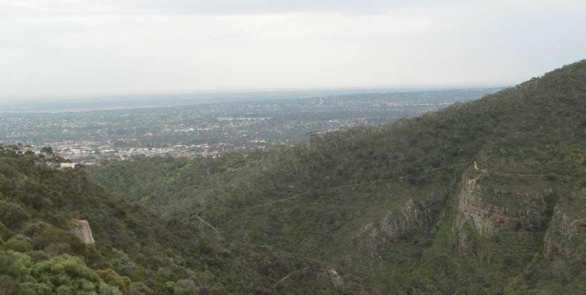
For further information please contact:
Department for Environment and Heritage
Phone Information Line (08) 8204 1910, or
see SA White Pages for your local
Department for Environment and Heritage office.
This Fire Management Plan is also available from: www.dehfire.sa.gov.au

Front Cover: Morialta Conservation Park by Henry Rutherford

Permissive Licence
© State of South Australia through the Department for Environment and Heritage. Apart from fair
dealings and other uses permitted by the Copyright Act 1968 (Cth), no part of this publication may
be reproduced, published, communicated, transmitted, modified or commercialised without the
prior written approval of the Department for Environment and Heritage.

Written requests for permission should be addressed to:
Design and Production Manager
Department for Environment and Heritage
GPO Box 1047
Adelaide SA 5001

Disclaimer
While reasonable efforts have been made to ensure the contents of this publication are factually
correct, the Department of Environment and Heritage makes no representations and accepts no
responsibility for the accuracy, completeness or fitness for any particular purpose of the contents,
and shall not be liable for any loss or damage that may be occasioned directly or indirectly
through the use of or reliance on the contents of this publication.

Reference to any company, product or service in this publication should not be taken as a
Departmental endorsement of the company, product or service.

© Department for Environment and Heritage
September 2009
EXECUTIVE SUMMARY

EXECUTIVE SUMMARY

This Fire Management Plan for the Reserves of the Hills Face Zone, Mount Lofty Ranges
includes 15 Department for Environment and Heritage (DEH) reserves: Angove, Black Hill,
Cleland, Eurilla, Ferguson, Giles, Horsnell Gully, Morialta and The Knoll Conservation Parks,
Anstey Hill, Blackwood Forest, Brownhill Creek, Cobbler Creek and Greenhill Recreation Parks,
and Belair National Park. The Mount Lofty Botanic Gardens and the DEH managed Mount
Osmond Reserve have also been included in the plan. The plan has been developed to
guide fire management activities, including bushfire suppression considerations in these on all
land managed by DEH in the Hills Face Zone. The plan emphasises the protection of life and
property and provides direction for land managers on the protection and enhancement of
the natural and cultural heritage of the planning area. It is important to note there will be a
transitional phase where the management strategies and works proposed in the plan are
undertaken and implementation will be dependant upon fire management priorities and the
allocation of regional resources.

The Reserves of the Hills Face Zone, Mount Lofty Ranges were identified as a priority for fire
management planning within the DEH Adelaide Region to address the following issues:

   •   The positioning of the reserves within the urban interface and the protection of
       significant built and natural assets adjacent to the reserves.

   •   The general protection of life, property and environmental values.

   •   Extreme overall fuel hazard levels in some areas of the reserves due to the long-term
       absence of fire and modification of the natural vegetation.

   •   Protection of fauna and flora species of conservation significance, some of which are
       unique to the Hills Face Zone.

   •   High visitor numbers.

   •   Regeneration and revegetation processes changing fuel hazards.

   •   The likelihood of arson and accidental fire ignitions.

The issues identified above were addressed during the planning process by:

   •   applying a risk assessment process to identify life, property and environmental values
       that may be threatened by bushfires

   •   applying DEH Fire Management zoning principles to guide the management of fuel in
       Asset and Buffer zones and designating Conservation zones

   •   applying DEH Ecological Fire Management Guidelines to determine appropriate fire
       regimes in Conservation zones

   •   auditing tracks within the reserves of this plan using the Government Agencies Fire
       Liaison Committee’s (GAFLC) guidelines for firebreaks and fire access tracks in South
       Australia.

The following recommendations as a result of applying the above processes have been
identified.

   •   Fuel reduction:

Reserves of the Hills Face Zone Fire Management Plan                                        i
EXECUTIVE SUMMARY
in Asset and Buffer zones using a variety of methods including prescribed
burning and mechanical removal
in strategic areas within the Conservation zone to provide some landscape
protection within the reserves and increase patchiness within the vegetation
(to reduce the possibility of a block or reserve burning in a single fire event)
to complement strategies to manage species’ habitats.
• Alteration and/or upgrade of fire access points and track classifications to increase
the:
safety of firefighting personnel involved in fire suppression activities
response time of fire suppression agencies
type of resources that can safely be deployed to assist in a fire suppression
effort.
• Identification of suppression considerations that may assist bushfire suppression
operations and to contribute to improved fire management.
This draft plan was released for public comment for a period of four weeks over November
and December 2007. Comments were then evaluated and incorporated where considered
appropriate. A major review of this plan will occur after ten years of implementation, or
earlier if required.
ii Reserves of the Hills Face Zone Fire Management PlanCONTENTS
CONTENTS
EXECUTIVE SUMMARY ............................................................................................................................ I
CONTENTS............................................................................................................................................. III
List of Tables ............................................................................................................................................. iv
List of Figures ............................................................................................................................................ iv
List of Attached Maps ............................................................................................................................ iv
1 SCOPE AND PURPOSE ................................................................................................................. 1
1.1 Objectives.......................................................................................................................................2
2 THE PLANNING FRAMEWORK...................................................................................................... 4
2.1 Legislation .......................................................................................................................................4
2.2 Policies and Procedures ...............................................................................................................5
2.3 State Planning ................................................................................................................................6
2.4 Local and Regional Environmental Planning............................................................................6
2.5 Reserve Management Planning .................................................................................................8
2.6 Vegetation Management Planning ...........................................................................................8
2.7 Partnership Agencies ....................................................................................................................9
2.8 Consultation ...................................................................................................................................9
2.9 Plan Review and Currency ........................................................................................................10
3 BUSHFIRE ENVIRONMENT .......................................................................................................... 11
3.1 Description of the Planning Area ..............................................................................................11
3.2 Values and Assets........................................................................................................................15
3.3 Pest Species..................................................................................................................................23
4 RISK ............................................................................................................................................ 26
4.1 Risk Assessment ............................................................................................................................26
4.2 Potential for Fire Ignitions............................................................................................................26
4.3 Fuel Hazard...................................................................................................................................26
5 READINESS ................................................................................................................................. 29
5.1 Equipment ....................................................................................................................................29
5.2 Training ..........................................................................................................................................29
5.3 Risk Mitigation Strategies ............................................................................................................29
6 RESPONSE .................................................................................................................................. 38
6.1 Response Plans.............................................................................................................................38
6.2 Suppression Considerations .......................................................................................................38
6.3 Visitor Management....................................................................................................................41
7 RECOVERY, RESEARCH AND MONITORING ............................................................................. 42
7.1 Post-Fire Rehabilitation and Recovery .....................................................................................42
7.2 Research .......................................................................................................................................42
7.3 Monitoring.....................................................................................................................................43
8 SUMMARY OF MANAGEMENT STRATEGIES .............................................................................. 45
9 REFERENCES............................................................................................................................... 48
10 APPENDICES .............................................................................................................................. 53
Appendix 1: Assets and Strategies for Risk Mitigation ......................................................................53
Reserves of the Hills Face Zone Fire Management Plan iiiCONTENTS
Appendix 2: Fire Response of Rated, Significant and Introduced Flora Species ........................65
Appendix 3: Fire Response of Rated and Significant Fauna Species............................................76
Appendix 4: Ecological Communities of Conservation Significance............................................82
11 SUMMARY OF CODES USED IN APPENDICES ........................................................................... 85
12 GLOSSARY OF ACRONYMS AND FIRE MANAGEMENT TERMINOLOGY .................................. 86
List of Tables
Table 1 – Likely Maximum Overall Fuel Hazard for MVS in the Planning Area.............................. 28
Table 2 – Fire Management Block Information ................................................................................. 34
Table 3 – Ecological Fire Management Guidelines for MVS in the Planning Area...................... 37
List of Figures
Figure 1 – The Planning Framework..................................................................................................... 4
Figure 2 – Annual Rainfall Averages for Some Reserves in the Planning Area............................. 12
Figure 3 – Visitor Numbers for Some Reserves in the Planning Area .............................................. 15
Figure 4 – Components of Fuel Layers in Vegetation....................................................................... 27
Figure 5 – Flow Chart Detailing the Burn Planning Process.............................................................. 33
Figure 6 – Approach for Determining Ecological Fire Management Guidelines ........................ 35
List of Attached Maps
Map 1 – Terrain, Tenure and Infrastructure
Map 2 – Vegetation Communities and Significant Species
Map 3 – Fire History
Map 4 – Fire Management and Access
iv Reserves of the Hills Face Zone Fire Management Plan1 SCOPE AND PURPOSE
1 SCOPE AND PURPOSE
The intention of this plan is to provide a strategic framework for fire management activities in
DEH Adelaide Region reserves that fall within the Hills Face Zone of the Mount Lofty Ranges.
This plan incorporates Angove, Black Hill, Cleland (and Mount Osmond Reserve), Eurilla,
Ferguson, Giles, Horsnell Gully, Morialta and The Knoll Conservation Parks; Anstey Hill,
Blackwood Forest, Brownhill Creek, Cobbler Creek and Greenhill Recreation Parks; Belair
National Park and Mount Lofty Botanic Gardens. The plan defines objectives for ecological
fire management and the protection of life and property, particularly in relation to visitors and
adjacent landholders. Strategies and works are suggested in order to allow the objectives to
be met. Risk mitigation works and activities will increase the level of bushfire preparedness
and guide management and suppression strategies during bushfire incidents.
These reserves were identified for fire management planning due to a number of factors:
• The positioning of the reserves within the urban interface and the protection of
significant built and natural assets adjacent to the reserves.
• The general protection of life, property and environmental values.
• Extreme overall fuel hazard levels in some areas of the reserves, due to the long-term
absence of fire and modification of the natural vegetation
• The protection of fauna and flora species of conservation significance, including the
Mount Lofty Ranges Chestnut-rumped Heathwren (Hylacola pyrrhopygia parkeri),
Southern Brown Bandicoot (Isoodon obesulus obesulus) and threatened orchids.
• High visitor numbers.
• Regeneration and revegetation processes changing fuel hazards.
• The likelihood of arson and accidental fire ignitions.
This Fire Management Plan aims to:
• assess the level of risk (particularly in relation to the above issues) and the existing fire
management and reserve management objectives
• identify objectives for fire management within the reserves
• outline strategies for risk mitigation and propose operational works to increase the
level of bushfire preparedness and guide suppression management during bushfire
incidents
• inform the preparation of Response Plans for the included reserves, which provide
specific operational information useful in the early stages of an incident.
Operational works outlined in this plan will be implemented in a staged manner depending
on available resources. These works will be facilitated through the DEH Adelaide Region and
prioritised by the respective Districts (in this case, Southern and Northern Lofty Districts) in
liaison with the Adelaide Regional Fire Management Unit. Adjoining lands are considered in
the plan, but only in the context of works required to minimise the risk to assets from fires
originating in the included reserves. However, DEH will support and complement landscape
scale fire planning for adjoining lands. Fire management planning for land outside of the
Reserves of the Hills Face Zone Fire Management Plan 11 SCOPE AND PURPOSE
reserves is the responsibility of the Adelaide Hills, Burnside, Mitcham, Salisbury and Tea Tree
Gully Bushfire Prevention Committees (DBPC), in accordance with the requirements of the Fire
and Emergency Services Act 2005. DEH is represented on these committees, along with Local
Government and the Country Fire Service (CFS).
In recent years DEH has reviewed and updated fire management planning to appropriately
address issues such as safety, protection of life and property, ecological management and
mitigation of fire risk. This approach has been carefully considered to ensure that the gap is
bridged between planning, on-ground actions and outcomes. Mechanisms are in place to
allow the plans to evolve and improve. Consultation with the community and stakeholders is
seen as critical to successful planning and has been built into the planning process.
1.1 Objectives
The fire management objectives that apply to all DEH reserves and DEH managed land are
as follows.
General Objectives for Fire Management
h To provide for the protection of human life and property during bushfire events.
h To ensure that sound conservation and land management principles are applied to
fire management activities (where information is available on species, habitat, cultural
and built heritage, then it will be taken into account during fire suppression activities
and when completing works for risk mitigation).
h To provide for the strategic containment of bushfires (e.g. to minimise the likelihood of
a fire entering/exiting a reserve).
h To complement Bushfire Prevention Plans.
h To undertake bushfire suppression activities in a safe and professional manner.
h To establish and maintain perimeter access.
h To manage fire regimes to ensure consistency with the fire management guidelines in
conservation zones (refer to Table 3).
The fire management objectives that apply specifically to the reserves of the Hills Face Zone
are as follows.
Objectives for Fire Management in the Hills Face Zone
h To reduce the impact of bushfire in the reserves by:
- minimising the likelihood of a significant portion of a reserve burning in a single
fire event
- minimising the likelihood of a landscape scale fire in the Hills Face Zone planning
area.
h To maintain or improve the viability of native species, populations, communities and
2 Reserves of the Hills Face Zone Fire Management Plan1 SCOPE AND PURPOSE
Objectives for Fire Management in the Hills Face Zone
habitats in reserves by
- reducing the likelihood of fire suppression operations impacting upon the
viability of native species, populations, communities and habitats
- reducing the likelihood of contiguous remnants of significant ecological
communities burning in their entirety during a single fire event
- creating a mosaic of areas with a range of different time since last fire, to
benefit a range of native species, populations, communities and habitats.
h To establish and maintain an appropriate level of preparedness (including employee
and equipment resources) that will enable rapid and effective response for fire
management by:
- preparing response actions that consider bushfire risk, including prevailing
weather, topography, overall fuel hazard, available resources, fire location and
the current situation
- assessing each fire and determining strategies promptly
- maintaining a safe working environment during fire operations, in compliance
with the Occupational Health Safety and Welfare Act 1986 and consistent with
DEH Policy
- using the functions, roles and responsibilities of the Australasian Interagency
Incident Management System (AIIMS).
h To improve knowledge of native species, populations, communities and habitats
response to fire by:
- undertaking ecological / experimental burns in order to examine the response of
a particular, or range of native species, populations, communities and habitats
to various fire regimes
- implementing ecological / experimental burns as part of integrated weed
management, in order to reduce the abundance of environmental weeds
posing a threat to the integrity of significant habitats / ecological communities.
Reserves of the Hills Face Zone Fire Management Plan 32 THE PLANNING FRAMEWORK
2 THE PLANNING FRAMEWORK
The policy and planning framework for fire management on DEH reserves is shown in Figure 1
(below). Reserve Management Plans provide the overarching strategy for all management
activities in reserves and are prepared as a requirement under the National Parks and Wildlife
Act 1972. Fire Management Plans are produced for reserves in accordance with Fire
Management Policy and Procedures. An outcome of the fire management planning process
is the identification of strategies and operational works for risk mitigation over a 10 year
period (as set out in Appendix 1). These works are prioritised and programmed into a works
schedule, which is prepared on an annual basis. Response Plans provide a greater level of
detail in regards to fire suppression. Response Plans are used in the early stages of an
incident and are reviewed annually to ensure currency.
FIGURE 1 – THE PLANNING FRAMEWORK
2.1 Legislation
2.1.1 Federal Legislation
The Federal Environment Protection and Biodiversity Conservation (EPBC) Act 1999 describes
the assessment and approval process required for actions likely to impact matters of national
environmental significance (e.g. Nationally listed species and ecological communities). This
fire management plan will be presented to the EPBC Act Referrals Unit prior to adoption.
2.1.2 State Legislation
Under the provisions of the South Australian National Parks and Wildlife (NPW) Act 1972, DEH
has responsibilities for fire management activities within reserves constituted under this Act.
The preparation of Fire Management Plans is not a statutory requirement under this Act, but a
Departmental Policy.
DEH is required to meet the provisions under the Native Vegetation Act 1991 when
prescribing any works that involve the clearance of native vegetation, or the use of fire (note
that fire is also defined as ‘clearance’ under the Act). All prescribed burns must be approved
through the process delegated to DEH by the Native Vegetation Council (NVC).
The South Australian Fire and Emergency Services Act 2005 outlines the responsibilities of DEH
and other fire authorities in relation to fire management within proclaimed reserves. Under
4 Reserves of the Hills Face Zone Fire Management Plan2 THE PLANNING FRAMEWORK
this Act, the Chief Officer (CFS) must take steps to have any relevant provisions of a
management plan for a government reserve brought to the attention of members of CFS
who might exercise powers under this section with respect to the reserve.
All landholders are obliged to comply with the Fire and Emergency Services Act 2005, which
outlines responsibilities for fire preparedness. DEH will implement works for fire management
on DEH managed lands within the planning area; however adjoining landholders are also
required to implement works on their own property to minimise the threat of fire. Note that
the Fire and Emergency Services Act 2005 is currently undergoing review.
As a result of the recent Ministerial Review of Bushfire Management in South Australia
(Monterola, 2007) amendments to the Fire and Emergency Services Act 2005 have been
recommended, as well as changes in regards to landscape fire management planning and
the management framework. As a result of the review the requirement for District Bushfire
Prevention Committees will cease and regional Bushfire Management Committees will be
established to address fire management at a landscape scale. CFS prepared Bushfire
Management Plans will replace District Bushfire Prevention Plans, which are generally
prepared by local Government. Bushfire Management Plans will be developed,
implemented and reviewed, incorporating a broader perspective on bushfire management
values and local knowledge through an expanded number of stakeholders and increased
community engagement.
2.2 Policies and Procedures
2.2.1 DEH Fire Management Policy
DEH has a Fire Management Policy which states that “DEH will manage fire in the State’s
reserve system to protect life, property and environmental assets and enhance the
conservation of natural and cultural heritage” (DEH, 2005e). This policy outlines a number of
key principles relating to bushfire suppression, prescribed burning and fuel reduction:
• Fire is recognised as a natural component of the South Australian environment and
ecosystems conserved in the reserve system.
• The maintenance of biodiversity and ecosystem processes in reserves depends on
appropriate fire regimes.
• Fire should be managed in a way that protects and maintains biodiversity values, as
well as providing for the protection of life and property.
The policy also states that “DEH is committed to the planned use of fire (prescribed burning)
as a management tool for reducing fuel hazard to protect life, property and biodiversity
values, and for ecological management” (DEH, 2005e). Property protection activities, where
recognised as a priority, will be carried out in such a way as to minimise the negative impacts
on biodiversity.
The policy specifies that Fire Management Plans will provide the framework for:
• the management of bushfire suppression, including identification of strategic access
and control lines; and
• prescribed burning for ecological management and fuel reduction purposes.
Reserves of the Hills Face Zone Fire Management Plan 52 THE PLANNING FRAMEWORK
2.2.2 Policy and Procedure for Fire Management Zoning in DEH Fire Planning
DEH has a Zoning Policy that outlines the zoning standard that is used for fire management
planning on DEH managed lands (DEH, 2006a). Zoning is derived from:
• the level of perceived risk, using the Policy and Procedure for Risk Assessment in DEH
Fire Planning (DEH, 2006b)
• the overall fuel hazard, which is assessed using the Overall Fuel Hazard Guide for
South Australia (DEH, 2006c)
• the activities considered appropriate to mitigate the threat that fire poses to life,
property and environmental assets.
Three distinct zones exist: Asset zone (A-zone), Buffer zone (B-zone) or Conservation zone (C-
zone) and these are applied according to landscape objectives. A- and B-zones are
determined by fuel management objectives whereas C-zones are designated to assist in the
conservation of biodiversity through the application of appropriate fire regimes. For more
information on zoning, refer to Section 5.3.3 of this plan and the Policy and Procedure for Fire
Management Zoning in DEH Fire Planning (DEH, 2006a).
2.2.3 Policies and Procedures for Response
The following Policies and Procedures are to be used in conjunction with this Fire
Management Plan during an incident:
• DEH Fire Management Policy.
• DEH Fire Management Policy and Procedures (covering various aspects of fire
management).
• CFS Chief Officer Standing Orders (COSOs).
• CFS Standard Operating Procedures (SOPs).
• CFS Operations Management Guidelines (OMGs).
Strategies implemented during an incident will be determined by the Incident Management
Team (IMT), taking this plan into consideration in accordance with Section 97 of the Fire and
Emergency Services Act 2005.
2.3 State Planning
The State Government has prepared the No Species Loss – A Nature Conservation Strategy
for South Australia 2007 – 2017 (DEH, 2007a) document in order to set targets for statewide
biodiversity conservation. The Strategy is a direct, whole of government partnership response
to the ‘lose no species’ target identified in the South Australian Strategic Plan (DPC, 2004).
The Strategy identifies inappropriate fire regime as a threat to biodiversity in SA (DEH, 2007a).
2.4 Local and Regional Environmental Planning
The objectives, strategies and works outlined in this Fire Management Plan were developed
with consideration given to providing for the maintenance of ecological integrity. The
6 Reserves of the Hills Face Zone Fire Management Plan2 THE PLANNING FRAMEWORK
following local and regional environmental plans were reviewed during the development of
this Fire Management Plan to ensure consistency with these documents.
2.4.1 Biological Survey of South Australia
The Reserves of the Hills Face Zone are part of the Flinders Lofty Block IBRA Region (Interim
Biogeographical Regionalisation for Australia) (DEH (Cwlth), 2005), which has survey data
included within the Biological Survey of the Southern Mount Lofty Ranges (Armstrong, et al.,
2003). This survey was conducted as part of the greater Biological Survey of SA. The following
objectives were identified within the survey (Armstrong, et al., 2003).
• Improving knowledge of South Australian biodiversity
• Determining biological variation across the state
• Managing nature conservation in the long-term.
2.4.2 Regional Biodiversity Report
A regional biodiversity report, entitled Informing Biodiversity Conservation for the Adelaide
and Mount Lofty Ranges Region – Priorities, Strategies and Targets has recently been finalised
(DEH, 2009). Recommendations from the report will be implemented in order to guide the
conservation, management and rehabilitation of habitats at a regional level (DEH, 2009).
2.4.3 Natural Resources Management Plan
A Natural Resource Management Plan has been developed for the Adelaide and Mount
Lofty Ranges region that identifies ‘inappropriate fire regime’ as a threat to terrestrial diversity
(AMLR NRM Board, 2007). The report recognises that changing climate may lead to increased
frequency and severity of bushfires (AMLR NRM Board, 2007). Fire is also identified as a threat
to surface water quality (AMLR NRM Board, 2007).
2.4.4 Recovery Plans
Recovery Plans are prepared for nationally threatened species that are listed under the EPBC
Act. In the Hills Face Zone, a number of species and communities of national conservation
significance have been recorded and the following species either have Recovery Plans that
are under development or in place.
• Southern Brown Bandicoot (Haby and Long, 2005)
• Several species of orchid including the White Spider-orchid (Caladenia rigida), Leafy
Greenhood (Pterostylis cucullata) and Pink-lipped Spider-orchid (Caladenia behrii)
(Bickerton, 1999; Quarmby, 2006)
DEH is currently undertaking investigations into habitat requirements and fire response of the
Nationally threatened MLR Chestnut-rumped Heathwren. Recommendations from these
Recovery Plans are discussed in more detail in Section 3.2.4. Data relating to significant
species that occur within the planning area are shown on Map 2.
A regional Recovery Plan has been prepared to explore a more strategic and integrated
approach to threatened species recovery and threat abatement in the Adelaide and Mount
Reserves of the Hills Face Zone Fire Management Plan 72 THE PLANNING FRAMEWORK
Lofty Ranges Region (Willson and Bignall, 2009). A total of 203 species and subspecies and 18
threatened terrestrial ecological communities have been included in the plan. Inappropriate
fire regimes and fire management activities (such as prescribed burning and other risk
mitigation works) have been identified as a threat to a number of these species. The plan
details the following actions for DEH:
• Improve knowledge of fire responses of priority species which are fire sensitive or fire
dependent.
• Improve information quality and dissemination for prescribed burning and fire
suppression activities to protect and manage threatened species and ecological
community locations.
2.5 Reserve Management Planning
Reserve Management Plans are a statutory requirement under the NPW Act or the Wilderness
Protection Act 1992. Reserve Management Plans provide the overarching strategy for all
management activities in reserves.
In relation to fire, a Reserve Management Plan will:
• provide an overview of any fire-related issues in the reserve in question
• state DEH responsibilities for managing fire in the reserve system in accordance with
DEH Fire Management Policy
• identify the requirement for a Fire Management Plan based on the nature of any fire-
related issues.
Reserve Management Plans have been developed for the following reserves in the Hills Face
Zone.
• Angove Conservation Park (DEH, 2005g).
• Anstey Hill Recreation Park (DEH, 2006l).
• Belair National Park (DEH, 2003d).
• Black Hill and Morialta Conservation Parks (DEH, 2001).
• Blackwood Forest Recreation Park (DEH, 2005f).
• Brownhill Creek Recreation Park (DEH, 2003c).
• Cleland Conservation Park (DEP, 1983).
• Cobbler Creek Recreation Park (DEH, 2003a).
• Ferguson Conservation Park (DEP, 1984).
• Greenhill Recreation Park (Draft) (DEP, 1985).
2.6 Vegetation Management Planning
Vegetation Management Plans are compiled as a means to identify a prioritised, strategic
and sustainable approach to mitigating the impact of pest plants on natural ecosystems
(Paul and Incoll, 2001). Unlike Reserve Management Plans, they are not a legislative
8 Reserves of the Hills Face Zone Fire Management Plan2 THE PLANNING FRAMEWORK
requirement under the NPW Act or Wilderness Protection Act 1992 and are completed on an
ad hoc basis for selected DEH reserves depending on resource availability. Vegetation
Management Plans have been prepared for eight of the 15 reserves included in this Fire
Management Plan.
• Belair National Park (Paul, 1998).
• Black Hill Conservation Park (Paul, 2001; Te, 2000).
• Blackwood Forest Recreation Park (Smytherman, 2003).
• Brownhill Creek Recreation Park (DEH, 2000; Kinnear, et al., 2001).
• Cleland and Eurilla Conservation Parks (DEH, 2002e).
• Cobbler Creek Recreation Park (Robertson, 2002).
• Morialta Conservation Park (DEH, 2005d).
Vegetation Management Plans prepared for any of the reserves in the planning area in the
future should take the zoning and strategies within this Fire Management Plan into
consideration when planning sites for revegetation. Any revegetation should be planned in
conjunction with the relevant District Ranger and in consultation with the Adelaide Region
Senior Fire Management Officer.
2.7 Partnership Agencies
The South Australian CFS is the lead combatant agency for bushfire suppression in rural South
Australia. Responding to a fire in DEH reserves is undertaken jointly by DEH and other CFS
Brigades (note DEH is a CFS Brigade under the Fire and Emergency Services Act 2005). Within
the planning area the Metropolitan Fire Service (MFS) will respond to bushfires within reserves
in their response zone (Map 1). Within reserves in the MFS response zone, MFS is the lead
authority for bushfires. Coordination between the agencies is essential in maintaining fire
management operations and implementing fire preparation, mitigation and suppression
activities.
SA Water and DEH have developed a Memorandum of Understanding (MOU) for fire
suppression operations on SA Water managed land. This arrangement is critical in
complementing fire management works undertaken on DEH reserves, particularly where they
are adjacent to SA Water lands.
All fire management planning and works undertaken on DEH land are subject to consultation
with local government to ensure that they are consistent with the objectives of the respective
Regional and District Bushfire Management Plans (formerly Bushfire Prevention Plans).
2.8 Consultation
DEH is committed to close cooperation and involvement with State and Commonwealth
organisations, special interest groups and the broader community to achieve the goals of
biodiversity conservation and protection of life and property. To achieve this, the CFS, Local
Government, Friends of Parks, Adelaide and Mount Lofty Ranges Natural Resources
Management Board have been consulted during the development of the plan.
Reserves of the Hills Face Zone Fire Management Plan 92 THE PLANNING FRAMEWORK DEH Fire Management Plans are prepared and adopted in accordance with the Policy and Procedure for Fire Management Planning: Project Management and Consultation (DEH, 2007b). Consultation is not a statutory requirement for Fire Management Plans, but is a Departmental Policy. The plan was subject to DEH internal consultation for a period of four weeks prior to being released externally for public consultation (for four weeks over November and December 2007). The finalised plan was then adopted by the Executive Director, Regional Conservation Delivery and the Executive Director, Conservation Policy and Programs. 2.9 Plan Review and Currency This Fire Management Plan will undergo a major review after ten years of implementation, or earlier if required. A works program will be derived from the recommendations listed in this Fire Management Plan and reviewed on an annual basis. 10 Reserves of the Hills Face Zone Fire Management Plan
3 BUSHFIRE ENVIRONMENT

3     BUSHFIRE ENVIRONMENT

The components of any landscape contributing to its bushfire potential include terrain, slope
and aspect, climate and weather, vegetation and land use.

3.1       Description of the Planning Area

3.1.1      Location

The Hills Face Zone extends approximately 100 km of the higher elevations of the western
face of the Mount Lofty Ranges, from Gawler in the north to Sellicks Hill in the south, covering
just over 30 000 ha (Planning SA, 2004). The Hills Face Zone has been protected from
excessive development under planning legislation since the 1960’s and as a result, currently
22% of the Hills Face Zone supports native vegetation, with about half of this protected within
DEH reserves (Planning SA, 2004).

This plan addresses fire management issues associated with the 15 DEH reserves and DEH
managed lands that fall within a 30 km length of the central Hills Face Zone. For the purpose
of this Fire Management Plan, the 30 km length, extending from Cobbler Creek Recreation
Park (RP) in the north to Blackwood Forest RP in the south, will be known as the ‘planning
area’.

Six councils are included in the planning area (Map 1), these are:

      •    City of Mitcham

      •    City of Burnside

      •    Adelaide Hills Council

      •    Campbelltown City Council

      •    City of Tea Tree Gully

      •    City of Salisbury.

The planning area forms part of the Mount Lofty Ranges Bushfire Prone Area. The MLR Bushfire
Prone Area spans from the Barossa Valley in the north to the Fleurieu Peninsula in the south
(Planning SA, 2006).

3.1.2      Surrounding Land Tenure

Areas adjoining the reserves have a variety of land uses including agriculture and horticulture,
educational facilities, public institutions, recreational reserves, built-up areas, quarrying,
forestry and conservation (Map 1). Adjoining land tenure includes land managed by SA
Water, ForestrySA and privately owned land (Map 1).

The urban area of the Adelaide Plains begins at the western edge on the lower slopes of the
Mount Lofty Ranges and extends through to the coast. Urban development abuts many of
the reserves covered in this Fire Management Plan. To the east development is generally
classified as rural and many of these towns are positioned upslope from the reserves. Water is
generally difficult to source for firefighting, as there are few dams. Map 1 provides an
overview of built up areas.

Reserves of the Hills Face Zone Fire Management Plan                                         11
3 BUSHFIRE ENVIRONMENT
3.1.3 Terrain
The Hills Face Zone planning area incorporates the western aspect of the Mount Lofty Ranges
and includes Mount Lofty, South Australia’s highest point, a heavily vegetated peak rising
above Cleland Conservation Park (CP). The zone is characterised by rugged topography
and is generally dominated by Stringybarks and an Extreme overall fuel hazard. There is
contiguous vegetation from Anstey Hill RP in the north to Belair National Park (NP) in the south.
This combination of slope and fuel contributes to the fire danger.
3.1.4 Climate and Fire Weather
The Hills Face Zone experiences cool, wet winters and warm to hot, dry summers. Rainfall
occurs primarily within the winter period, from May to September. Rainfall averages vary
across the planning area with reserves on the lower slopes receiving from as little as 500 mm
annually to reserves at the higher elevations receiving over 1000 mm annually (Figure 2).
Average Rainfall for reserves in the planning area
1000
900
800
700
Annual Rainfall (mm)
600
500
400
300
200
100
0
Cleland & Eurilla CP Mount Lofty Botanic Black Hill & Morialta CP Anstey Hill RP Angove CP Cobbler Creek RP
Gardens
Reserve
FIGURE 2 – ANNUAL RAINFALL AVERAGES FOR SOME RESERVES IN THE PLANNING AREA
During winter, westerly winds travel across South Australia bringing moisture to the
metropolitan area. However, during the summer months the wind system moves south
causing hot dry winds originating from central Australia to blow from the north. The planning
area is also subject to local wind effects with the regular occurrence of ‘gully winds’. Gully
winds occur when cool air descends from the top of the Mount Lofty Ranges replacing the
warmer air of the Adelaide plains. These winds most frequently occur during the summer
months, generally in the late afternoon and evening and are usually strong and variable in
direction.
12 Reserves of the Hills Face Zone Fire Management Plan3 BUSHFIRE ENVIRONMENT
Extreme Fire Conditions
Strong winds, combined with high temperatures and low humidity increases the likelihood of
extreme fire intensity and behaviour. Under such conditions suppression activities are unlikely
to be effective in areas supporting Very High and above overall fuel hazard levels (DEH,
2006c) and suppression activities will be confined to the protection of life and property. There
is a dramatic increase in the likelihood of major bushfire events when the following conditions
are experienced:
• Very High to Extreme overall fuel hazard levels in native vegetation
• low humidity, decreased soil and fuel moisture, particularly during drought years
• strong winds shifting direction during the course of a fire (especially westerly wind
changes)
• lightning strikes as a result of increased thunderstorm activity between late November
and December, then again around mid March to early April
• steep terrain.
3.1.5 Fire History
Mapping Fire Occurrences
The fire history map (Map 3) has been compiled from the latest DEH fire incident reports. The
quality of the firescar mapping varies, depending on the method of capture. It is important
to note that only visible fire scars over 0.5 ha in size have been mapped and that mapping is
limited to fires that have occurred on DEH managed land or fires where DEH was in
attendance. Consequently, the mapped fires should be regarded as a minimum estimate of
fire occurrences.
The fire history map (Map 3) shows two representations of the same data, fire frequency (left
frame) and last fire (right frame). Fire frequency shows the number of times an area has been
burnt, assuming only one fire per calendar year. Recent fires (last 10 years) are shown with
hatching and labelled with year. The last fire map shows the same data classified into five
year class intervals. In combination, Map 3 shows that the planning area is dominated by a
single fire event that occurred over 20 years ago (Ash Wednesday fires).
Natural and Anthropogenic Fires
Detailed records of recent fire incidents that have occurred within DEH reserves are stored
within the Department’s fire reporting database. This database along with spatial records
and any other historical records was reviewed during the development of this Fire
Management Plan.
Historically a number of large fires have been recorded throughout the planning area, the
most recent include:
• a 777 ha fire that burnt most of Morialta CP in 1972. This fire also burnt land to the
south of the reserve
• the Ash Wednesday fires of 1983. These fires burnt six DEH reserves within the planning
area, including all of Eurilla CP and Greenhill RP. Significant sections of Cleland CP,
Reserves of the Hills Face Zone Fire Management Plan 133 BUSHFIRE ENVIRONMENT
Anstey Hill RP, Horsnell Gully CP and Giles CP were burnt, as well as DEH managed
land including the Mt Lofty Botanic Gardens and Mount Osmond Reserve
• a fire that burnt Black Hill CP in its entirety in 1985. This fire was part of a larger 1 616 ha
fire that burnt land to the east of the reserve.
Since 2001, approximately 80 records pertaining to bushfire incidents have occurred within or
in close proximity to the reserves in the planning area. Some of the larger incidents include:
• a 60 ha fire that burnt 55 ha of Morialta CP, adjacent Montacute Road in 2004. This
same area was also subject to fires in 1982 and 1998
• a 100 ha fire that started within Anstey Hill RP and burnt 40 ha of DEH reserve before
burning into adjacent land in 2004
• a 140 ha fire at Mount Osmond adjacent the Princes Highway in January 2005.
A significant number of fires within the Hills Face Zone have been attributed to anthropogenic
ignitions, including campfires, car fires, suspected arson, burn offs on adjacent land and
sparks from machinery use. Suspected arson is the most frequent cause of ignition, with
approximately 40 incidents within the planning area since 2001.
Fires attributed to natural causes, such as ignition by lightning are not as common within the
planning area. A small fire within Horsnell Gully CP was caused by lightning in 2002.
Prescribed Burning
Prescribed burning has been undertaken within nine of the 15 reserves included in this Fire
Management Plan; these are Anstey Hill RP, Belair NP, Black Hill RP, Cleland CP, Cobbler
Creek RP, Giles CP, Horsnell Gully CP, Morialta CP and Mt Lofty Botanic Gardens.
As part of the planning process, areas have been identified for prescribed burning across the
planning area (Map 4). The implementation of these burns is subject to resource availability
and regional priorities. Potential burn areas may be altered, or may be withdrawn at the
discretion of DEH as a result of unplanned fires or other factors that may have occurred since
time of writing. Each burn area identified on Map 4 may not be burnt in its entirety at one
point in time, as the area may be divided and burnt over a number of seasons or the burn
itself may be patchy. Proposed burns are subject to the planning process described in
Section 5.3.4.
3.1.6 Vegetation Communities
Major Vegetation Sub-groups (MVS)
Floristic mapping for this plan uses a compilation of regional vegetation mapping data that
has been reclassified to comply with the National Vegetation Information System (NVIS)
classification for Australia. The MVS level of the NVIS classification emphasises the structural
and floristic composition of the dominant stratum but with additional types identified
according to typical shrub or ground layers occurring with a dominant tree or shrub stratum.
There are eight MVS within the planning area that have been mapped by DEH. Map 2 shows
the distribution of MVS in the planning area. Table 1 lists the species composition for each
MVS and the Ecological Fire Management Guidelines are outlined in Table 3.
14 Reserves of the Hills Face Zone Fire Management Plan3 BUSHFIRE ENVIRONMENT
The Major Vegetation Sub-groups represented in the planning area are:
• MVS No. 4 Eucalyptus forests with a shrubby understorey
• MVS No. 8 Eucalyptus woodlands with a shrubby understorey
• MVS No. 9 Eucalyptus woodlands with a grassy understorey
• MVS No. 21 Other Acacia tall open shrublands and shrublands
• MVS No. 26 Casuarina and Allocasuarina forests and woodlands
• MVS No. 32 Other shrublands
• MVS No. 37 Other tussock grasslands
• MVS No. 38 Wet tussock grassland, herbland, sedgeland or rushland
These MVS differ from the broad vegetation groups defined within the draft Biodiversity
Strategy for the Adelaide and Mount Lofty Ranges (DEH, in prep), although there are
significant similarities. Within this Fire Management Plan MVS have been used as these
groupings are accepted by fire managers for predicting maximum overall fuel hazard levels
(Section 4.3.2).
3.2 Values and Assets
3.2.1 Visitor Use
The reserves of the Hills Face Zone receive a large number of visitors per year. Visitor numbers
for reserves are shown as approximate numbers collected for the 2006 to 2007 financial year
by DEH (Figure 3).
Annual visitor numbers for major reserves in the planning area (2006/7)
700000
600000
500000
400000
Visitor numbers
300000
200000
100000
0
Cleland CP Belair NP Mt Lofty Botanic Gardens Morialta CP Anstey Hill RP
Reserve
FIGURE 3 – VISITOR NUMBERS FOR SOME RESERVES IN THE PLANNING AREA
Reserves of the Hills Face Zone Fire Management Plan 153 BUSHFIRE ENVIRONMENT
As these figures only reflect the number of people that cross the data collection points, it can
be assumed that actual visitor numbers are higher. A range of day-use recreational activities
are undertaken in these reserves. Camping is not permitted in metropolitan DEH reserves and
as a result, visits are generally short-term, undertaken during the daylight hours.
Management Strategies
1. Implement appropriate fuel management strategies as shown on Map 4 to
Visitor Use
increase visitor safety.
2. Consider reserve closures on extreme fire weather days to ensure visitor safety at
the discretion of the Director National Parks (Executive Director Conservation
Policy and Programs) or delegate.
3.2.2 Built Assets
There are a number of built assets at risk from bushfires within the reserves including:
• Cleland Wildlife Park
• Mount Lofty Botanic Gardens
• Mt Lofty Summit Visitor Centre
• Mt Lofty Fire Tower and associated assets
• Waterfall Gully kiosk
• DEH worksites at Black Hill CP, Cleland CP and Belair NP
• Brownhill Creek Caravan Park
• Communication towers
• Several heritage listed buildings, including Old Government House at Belair NP
• Visitor facilities and infrastructure in Belair NP, Cleland CP and Morialta CP.
DEH will undertake fire management works and activities to minimise the likelihood of fire
impacting built assets, (both public and private buildings).
Appendix 1 details significant assets within and adjacent the reserves and the corresponding
fire management strategies. Map 1 shows the location of assets within the planning area.
16 Reserves of the Hills Face Zone Fire Management Plan3 BUSHFIRE ENVIRONMENT
Management Strategies
3. Implement fuel management strategies appropriate to asset protection as shown
on Map 4.
4. Encourage adjacent property owners to work with CFS to implement appropriate
Built Assets
and coordinated fire management works on their own land to minimise the threat
of fire.
5. Undertake fire management works and activities on DEH reserves to minimise the
impact that fire may pose to adjacent public assets.
6. Encourage volunteer participation in undertaking approved fuel reduction
activities.
3.2.3 Cultural Assets
Aboriginal Heritage
The land comprising the Reserves of the Hills Face Zone forms part of the ‘Country’ of the
Kaurna people and the Peramangk people as described by Tindale (1974). The Peramangk
people occupied the Mount Lofty Ranges east through to Strathalbyn. The Kaurna people
occupied the Adelaide Plains, west of the Mount Lofty Ranges, only visiting the Ranges during
spring and autumn. It is thought that the Stringybark forests of the Mount Lofty Ranges
marked the eastern boundary of Kaurna Country. Mount Bonython and Mount Lofty are
featured in Kaurna Dreaming.
Aboriginal heritage sites have been recorded throughout the Hills Face Zone. Belair NP,
Cobbler Creek RP and Brownhill Creek RP contain sites that have been listed on the Central
Archive, which includes the Register of Aboriginal Sites and Objects (the Register). There is
also a listed site east of Horsnell Gully CP. It should be noted that the Register is not a
comprehensive record of all Aboriginal sites and objects in South Australia, therefore sites or
objects may exist in the planning area, even though the Register does not identify them.
When implementing this plan, DEH will comply with the Aboriginal Heritage Handbook and
Strategy (DEH, 2006e), to facilitate the protection of sites during bushfire suppression and
prescribed burns. Information on Aboriginal heritage is collected during prescribed burn
planning as part of the Environmental Assessment Table (EAT) (refer to Section 5.3.4).
European Heritage
The European heritage of the Hills Face Zone was recently catalogued through the Adelaide
Hills Face Zone Cultural Heritage Project. An outcome of the project was the publication of a
book detailing the nineteenth century colonisation on the western face of the Mount Lofty
Ranges (Smith, et al., 2006).
Details on European heritage assets can be found within Valleys of Stone - The Archaeology
and History of Adelaide's Hills Face (Smith, et al., 2006).
Reserves of the Hills Face Zone Fire Management Plan 173 BUSHFIRE ENVIRONMENT
Management Strategies
7. Implement fuel management strategies appropriate for the protection of cultural
Cultural Assets
assets as shown on Map 4.
8. Ensure liaison at bushfires occurs to identify cultural assets, where time allows.
Once the fire has passed evaluate sites to establish if any damage has occurred.
9. Ensure suppression strategies take into account significant cultural assets in order
to minimise impacts from these activities and undertake post-fire rehabilitation.
3.2.4 Natural Values
Flora, Fauna and Ecological Communities
The Environmental Database of South Australia contains records from several data sources,
including the Threatened Plant Population Database, the Biological Survey of South Australia
and opportunistic sightings of significant flora and fauna.
Fire response information, where known, is included for species and communities of
conservation significance in Appendix 2, 3 and 4.
In this plan ‘of conservation significance’ is used to describe rated populations or species of
flora and fauna as well as vegetation communities. These may be:
• Nationally rated, that is, listed as Threatened (with a rating of Extinct, Critically
Endangered, Endangered or Vulnerable) under the federal EPBC Act
• South Australian rated, listed as Threatened (with a rating of Endangered, Vulnerable
or Rare) under the NPW Act, Revised Schedules 7, 8 and 9
• Provisionally listed as Threatened (with a rating of Endangered or Vulnerable) in South
Australia, that is, included on the unpublished DEH Provisional List of Threatened
Ecosystems of South Australia (DEH, 2005c).
There are a number of flora and fauna species as well as ecological communities considered
to be of conservation significance within the planning area. This includes five Nationally
Endangered species.
• Mount Lofty Ranges (MLR) Chestnut-rumped Heathwren.
• Southern Brown Bandicoot.
• Pink-lipped Spider-orchid.
• White Spider-orchid.
• Osborn’s Eyebright (Euphrasia collina ssp. osbornii).
Appendix 2 and 3 contains a list of flora and fauna of conservation significance as well as
species that are considered important in terms of fire management. Note that this is not
intended to be an exhaustive list of rated species as it does not consider species that are
regionally significant, but attempts to summarise the current level of fire response knowledge
for particular species. Appendix 4 summarises information on threatened ecological
communities.
18 Reserves of the Hills Face Zone Fire Management PlanYou can also read