Abercrombie River
     National Park
Fire Management Strategy
←
→
Page content transcription
If your browser does not render page correctly, please read the page content below
Abercrombie River
National Park
Fire Management Strategy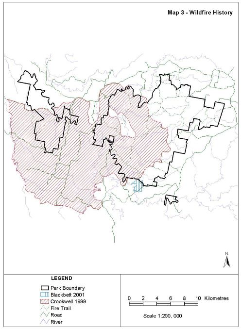
NSW NATIONAL PARKS AND WILDLIFE SERVICE

   FIRE MANAGEMENT STRATEGY

ABERCROMBIE RIVER NATIONAL PARK

 NSW National Parks and Wildlife Service
       Blue Mountains Region
              June, 2005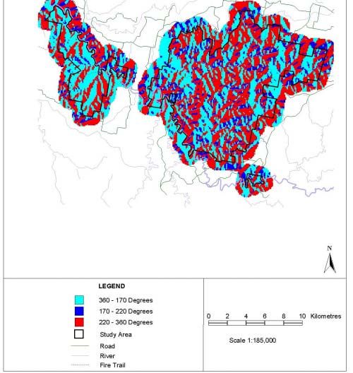
Abercrombie River National Park Fire Management Strategy

                              ACKNOWLEDGMENTS

                The 2001 document was principally prepared by

                          Conacher Travers Pty Ltd
                      Bushfire and Ecological Consultants
                    70 Chivers Road, Somersby NSW, 2250.
                     (ph) 02 4372 1244 (fax) 02 4372 1528
                    email bushfire@conachertravers.com.au

The following people and organisations made valuable contributions:

          Jules Bros                   NSW National Parks and Wildlife Service
          Marca de Beer                NSW National Parks and Wildlife Service
          Arthur Henry                 NSW National Parks and Wildlife Service
          Julie Pownall                NSW National Parks and Wildlife Service
          Saskia Hayes                 NSW National Parks and Wildlife Service
          Aotea Christenson            NSW National Parks and Wildlife Service
          Eddie Gibbons                Oberon Council
          Members                      Oberon Bushfire Management Committee
          Andrew Croft                 Forests NSW (Formerly State Forests)
          Debbie Mukhar                Forests NSW (Formerly State Forests)
          Richard Bell                 NSW Rural Fire Service – Jerrong/Paling
                                       Yards Brigade/neighbour
          John Byrne                   Landholder

Cover Photograph by: S. Douglas © National Parks and Wildlife Service

This book is copyright.
Apart from any fair dealing for the purposes of private study, research,
criticism or review, as permitted under the Copyright Act, no part may be
reproduced by any process without written permission. Inquiries should be
addressed to the NSW National Parks and Wildlife Service.

Published by the NSW National Parks and Wildlife Service, Blue Mountains
Region, June, 2005. Contact : PO Box 552, Katoomba. NSW 2780

Erratum: Please note that this Strategy was first drafted in 2001. It has had a
minor review to update it in 2004. Some contextual and timing inconsistencies
may still exist.

ISBN 1 74137 344 1

DEC 2005/186

                                            i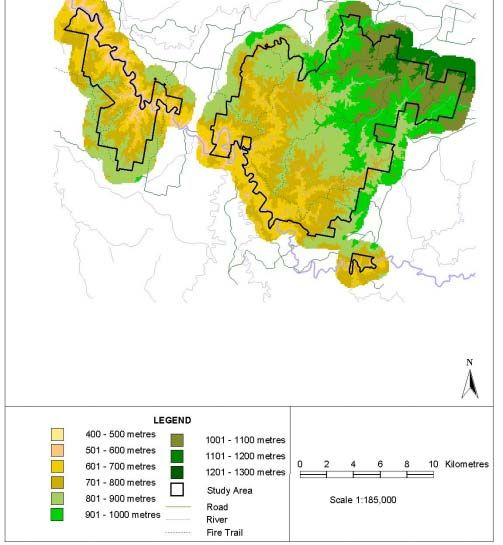
Abercrombie River National Park Fire Management Strategy

                              EXECUTIVE SUMMARY

PLANNING AND CONSULTATIVE PROCESS

This Fire Management Strategy provides direction for fire management
activities within Abercrombie River National Park (the Park) to fulfil the
Service’s obligations under various legislation and Government policy.

Importantly, under the Rural Fires Act, 1997, NPWS is both a fire fighting
authority and a public authority and therefore has dual responsibilities for fire
fighting and land management. This Fire Management Strategy fulfils NPWS
responsibilities under Sections 38 s4 and 44 s3 of the Rural Fires Act, 1997
and should be implemented accordingly.

Abercrombie River National Park has a number of threatened plants and
animals. This strategy will deal with the protection of these species and
communities through the implementation of appropriate fire management
regimes to promote biodiversity.

In consultation with local Bush Fire Management Committees, volunteer Rural
Fire Brigades, Park neighbours and other stakeholders, areas have been
prioritised for risk management treatment by assessing bush fire threat to
assets.

The co-operation of the community will be critical to the success of the
strategy. Neighbours will need to manage fuels near their own assets to
complement work undertaken in the Park.

Although every effort has been made to ensure accuracy of details from
existing databases, additional information is continually being collected and
management concepts and practices evolving. Therefore, it is proposed that
this strategy will have a shelf life of five years before a review is undertaken.

FIRE MANAGEMENT OBJECTIVES

The primary NPWS objectives for fire management are:

• To protect from bushfires, persons and property on, or immediately adjacent
  to the park.

• To suppress unplanned bushfires occurring in the Park.

• To minimise the potential for spread of bushfires on, from, or into the Park.

• To manage bushfires to avoid the extinction of all species which are known
  to occur naturally within the Park.

• To protect from damage by bushfires all Aboriginal sites, Historic places and
  culturally significant features known to exist within the Park.

                                       ii
Abercrombie River National Park Fire Management Strategy

    STRATEGIES FOR LIFE AND PROPERTY PROTECTION

Strategies for the protection of life and property from the effects of wildfires
included in the strategy are:

• Early detection and rapid suppression of all wildfires posing a threat to
  infrastructure assets, life and property within and adjoining the Park.
• Implementation of strategic fuel management programs within the Park.
• Promotion of fire safety and fire protection procedures to Park visitors and
  neighbours.
• Maintenance of a strategic fire trail network within the Park.

STRATEGIES FOR FIRE MANAGEMENT (WILDFIRE SUPPRESSION)

Strategies for the prevention, detection and control of wildfire that are included
in the strategy are:

• Emphasis on boundary fuel management measures to protect against
  direct flame attack on assets on / off Park.
• Aerial surveillance of the Park following severe thunderstorms.
• Maintenance of fire trails and utilities to assist with the suppression of
  wildfire.
• Early detection and rapid suppression of wildfires where possible.
• Monitoring of fuel levels within Strategic Fire Advantage Zones.
• Strategic fuel management to reduce the potential for large scale wildfires.
• Continued liaison with Bush Fire Management Committees, fire fighting
  authorities and park neighbours.

STRATEGIES FOR HERITAGE MANAGEMENT

Strategies for the management of the natural and cultural heritage values that
are included in the strategy are:

• The use or exclusion of fire to maintain a complex diversity of vegetation
  communities and age structures, prevent species extinctions and protect
  specific natural or cultural assets.
• Emphasis on fuel management along boundary areas to allow for
  ecologically sustainable fire regimes within core Park areas.
• Assessment of environmental impacts prior to any fire management
  activity.
• Pre-burning surveys for threatened species or Aboriginal / historic relics
  where possible.
• Monitoring vegetation re-generation following a prescribed burn where
  possible.
• Compliance with identified fire regime thresholds for all vegetation
  communities, threatened species and communities.
                                        iii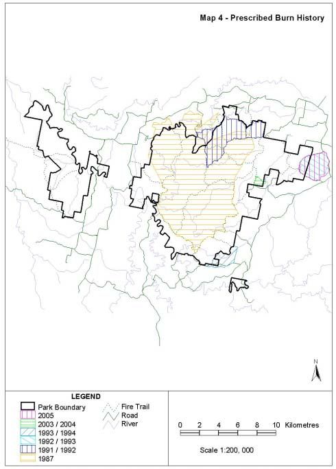
Abercrombie River National Park Fire Management Strategy
TABLE OF CONTENTS
1. INTRODUCTION 1
1.1 Scope and Purpose 1
1.2 Fire Management Objectives and Performance Indicators 1
1.3 The Planning Environment 6
1.3.1 Legislation 6
1.3.2 Fire Management Policies of the NPWS 7
1.3.3 Local-Regional Environmental Plans 8
1.3.4 State Environmental Planning Policies 8
1.3.5 Fire Management Policies-Regulations of Involved Organisations 8
1.3.6 NSW Biodiversity Strategy 9
2. DESCRIPTION OF THE PARK 10
2.1 Location 10
2.2 Terrain 10
2.3 Biodiversity 10
2.3.1 Flora 12
2.3.2 Fauna 16
2.3.3 Introduced Flora and Fauna 18
2.4 Cultural Heritage 19
2.4.1 Aboriginal 19
2.4.2 Historic 19
2.5 Recreational Use and Facilities 19
3. BUSHFIRE ENVIRONMENT 21
3.1 Fire History and Frequency 21
3.1.1 Unplanned Fires 21
3.1.2 Prescribed Burning 24
3.1.3 Fire Frequency 24
3.2 Fire Weather 24
3.2.1 Climate 25
3.2.2 Conditions Associated With Bush Fires 26
3.2.3 Conditions Suitable for Prescribed Burns 28
3.3 Fire Behaviour Potential 29
3.3.1 Elevation 29
3.3.2 Slope 29
3.3.3 Aspect 30
3.3.4 Fuel 34
3.3.5 Analysis of Likely Fire Behaviour (with a view to potential risk to
fire fighters & the effectiveness of refuge areas) 39
3.4 Damage Potential 39
3.4.1 Historical Damage 43
3.4.2 Economic Damage 43
3.4.3 Natural Heritage Damage 43
3.4.4 Cultural Heritage Damage 43
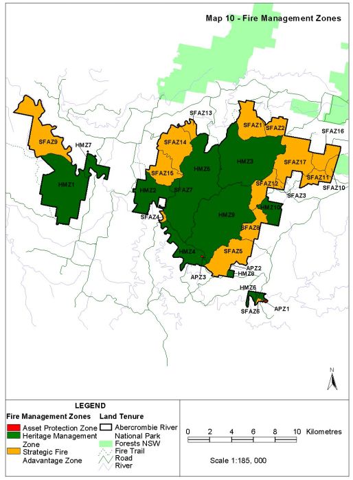
4. FIRE MANAGEMENT 44
4.1 Bushfire Management Zones 44
4.2 Asset Protection Zones 45
4.3 Strategic Fire Advantage Zones 45
4.4 Heritage Management Zones 47
4.5 Summary of Bushfire Management Zones 47
4.6 Biodiversity Conservation 48
4.6.1 Principles and Thresholds 49
4.6.2 Distribution of Biodiversity in Bushfire Management Zones 50
4.6.3 Evaluation of Current Fire Regimes 54
iv
Abercrombie River National Park Fire Management Strategy

    4.6.4 Effects of Management for Human Protection and Strategic
    Wildfire Control on Biodiversity                                          54
    4.6.5 Fire Regime Strategies for Biodiversity Conservation                55
  4.7 Aboriginal Heritage                                                     58
  4.8 Historic Heritage                                                       58
  4.9 Smoke Management                                                        59
  4.10 Summary of Operational Guidelines                                      59
    4.10.1 Guidelines for Co-operative Fire Fighting Arrangements             61
    4.10.2 Public Welfare and Safety                                          61
5. FIRE MANAGEMENT ASSETS                                                     62
  5.1 Fire Management Access                                                  62
  5.2 Fire Management Utilities                                               64
  5.3 Fire Management Facilities                                              67
    5.3.1 Control Room (Southern Tablelands Zone and Chifley Zone )           67
    5.3.2 Radio Network (Southern Tablelands Zone and Chifley Zone)           67
    5.3.3 Detection                                                           67
    5.3.4 Preparation Measures for Fire Suppression                           67
6. WORKS SCHEDULE                                                             69
  6.1 Biodiversity Works Schedule                                             69
    6.1.1 Fire Management Research                                            69
    6.1.2 Fire Mapping and Database Management                                69
    6.1.3 Monitoring Fuel                                                     69
    6.1.4 Monitoring Fire Regimes and Changes to Biodiversity                 70
  6.2 Operations Works Schedule                                               70
    6.2.1 Prescribed Burning                                                  70
    6.2.2 Hazard Reduction                                                    70
  6.3 Infrastructure Works Schedule                                           70
    6.3.1 Fire Management Access                                              70
    6.3.2 Fire Management Utilities                                           71
    6.3.3 Fire Management Facilities                                          71
  6.4 Summary Table of Works to be Undertaken Annually                        71
7. STRATEGY ADMINISTRATION                                                    73
  7.1 Management of Works                                                     73
  7.2 Environmental Assessment of Scheduled Works                             73
  7.3 Strategy Review                                                         73
  7.4 Implementation and Evaluation                                           73
  7.5 Life and Property Protection                                            74
  7.6 Maintenance of Biodiversity                                             74
  7.7 Further Research                                                        75
8. REFERENCES                                                                 77
  APPENDIX 1 Definitions and Principles                                       78
  APPENDIX 2 Fire Zone Specifications                                         84

                                    v
Abercrombie River National Park Fire Management Strategy

MAPS

Map 1 - Location of Park

Map 2 - Vegetation Communities within Abercrombie River National Park

Map 3 - Wildfire History

Map 4 – Prescribed Burn History

Map 5 - Elevation

Map 6 - Slope

Map 7 - Aspect

Map 8 - Fuel Categories

Map 9 - Bushfire Behaviour Potential Classes

Map 10 - Fire Management Zones

Map 11 - Minimum Inter-Fire Period For Species Conservation

Map 12 - Fire Trails

TABLES

Table 1 - Vegetation Communities within Abercrombie River National Park

Table 2 - Rare or Threatened Australian Plants (ROTAP) Species Located
Within Abercrombie River National Park

Table 3 - Regionally Significant Flora Species Located within Abercrombie
River National Park

Table 4 - Threatened Fauna that occur or are predicted to occur within
Abercrombie River National Park

Table 5 - Regionally Significant Fauna Species located within the Park

Table 6 - Climatic Records For Oberon

Table 7 - Climatic Records For Taralga and Crookwell

Table 8 - Variable Wind Direction Showing Percentage Occurrence

Table 9 - Slope Categories within Abercrombie River National Park

Table 10 - Aspect Categories within Abercrombie River National Park

Table 11 - Fuel Group Ratings

Table 12 – Fuel Group Ratings for Vegetation Communities
                                      vi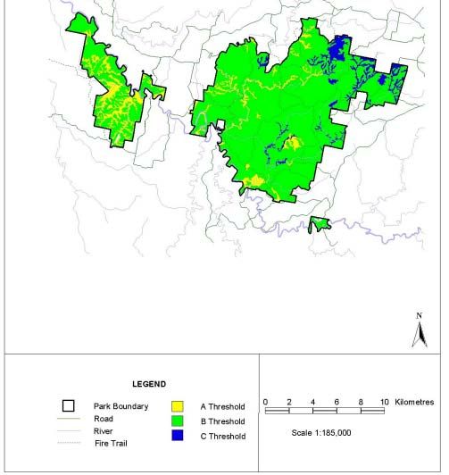
Abercrombie River National Park Fire Management Strategy

Table 13 - Bush Fire Behaviour Potential Classes and Percentage Area

Table 13a - Bushfire Behaviour Potential Class Determination

Table 14 - Desirable Fire Frequency For Varying Vegetation Communities

Table 15 - Distribution of Vegetation Types in Fire Management Zones within
Abercrombie River National Park

Table 16 - Fire Thresholds for Vegetation Communities within Abercrombie
River National Park

Table 17 - Fire Regimes / Strategies For Conservation of Flora Species

Table 18 - Key Characteristics of Fire Regimes which Impact Upon Fauna
Species

Table 19 - Fire Management Guidelines for Conservation of Threatened
Fauna Species

Table 20 - Operational Guidelines For Prescribed Burning and Wildfire
Suppression Within Abercrombie River National Park

Table 21 - Policies for Wildfire Suppression within the Park

Table 22 - Trail Classification

Table 23 - Trails Within and Adjacent to Abercrombie River National Park

Table 24 - Utilities and Equipment Held by the Kanangra Area of National
Parks and Wildlife Service

Table 25 - Utilities and Equipment Held by the Chifley Zone Rural Fire Service

Table 26 - Trail Maintenance Work within Abercrombie River National Park

Table 27 - Summary Table of Priority Works to be undertaken in Abercrombie
River National Park

Table 28 - Abercrombie River National Park Annual Works Schedule

                                        vii
1. INTRODUCTION
This Fire Management Strategy applies to the land area dedicated under the National
Parks and Wildlife Act, 1974, as Abercrombie River National Park (ARNP). This
National Park is managed by the Blue Mountains Region (Kanangra Area) of the
National Parks and Wildlife Service.
1.1 Scope and Purpose
Under the Rural Fires Act 1997, the National Parks and Wildlife Service (NPWS, or
the Service) is a prescribed fire organisation and is responsible for the control and
suppressing of all fires on areas that it manages. This responsibility also extends to
fuel management with the Service being responsible for the implementation of fuel
management programs to protect life and property.
Section 50 of the Rural Fires Act 1997 sets up provisions for the establishment of
District Bush Fire Management Committees (DBFMCs) with the task of developing
and co-ordinating co-operative fire management between fire authorities across the
state.
Within the scope of this Strategy the NPWS is an active member of the Chifley Zone
and Southern Tablelands Zone District Bush Fire Management Committees.
Under Section 52 of the Rural Fires Act, each Bush Fire Management Committee is
to prepare two kinds of bush fire management plans for the rural fire District or other
part of the state for which it is constituted. These plans are:
• A Plan of Operations, and
• A Bush Fire Risk Management Plan.
This Fire Management Strategy fulfils NPWS requirements under Sections 38 s4 and
44 s3 of the Rural Fires Act 1997 and should be implemented accordingly.
This Strategy has been prepared in accordance with the policies and procedures
detailed in the NPWS Fire Management Manual, NPWS Strategy for Fire
Management and the relevant Plan of Management. The Strategy has considered
the bush fire environment, bush fire risks and management strategies, prescribed
burning program and priorities identified in the Sydney Basin Fire Management
Strategy, and cooperative fire fighting agreements outlined in the relevant District
Bush Fire Management Committee Risk Management and Operations Plans.
Appendix 1 provides a glossary of terms used in this document.
1.2 Fire Management Objectives and Performance Indicators
Each fire management objective is listed below. Performance indicators complement
each objective and will be used as a means of gauging the effectiveness and
success of the plan. The data for the performance indicators will be obtained from
performance reporting and monitoring as indicated under each objective.
1Abercrombie River National Park Fire Management Strategy
OBJECTIVE 1
To prevent the occurrence of human caused unplanned fires on the Park.
Performance Indicator
i.On reserves with a history of unplanned fire, ignitions caused by humans are
progressively reduced over the planning period.
ii.On reserves, with no history of unplanned fire, there is no increase in ignitions
caused by humans over the planning period.
Performance Reporting and Monitoring
• Fire causes included in wildfire situation reports by Region.
• Fire Management Unit collates and analyses data and prepares NPWS
performance report.
Planning Notes
• Consider causes of human induced unplanned fire ignitions eg. arson, burning
off, camping, cooking, railways, powerlines, machinery etc.
• Develop bushfire prevention strategies for reducing the frequency of these
fires eg surveillance, investigations, law enforcement, public education, fire
bans, closures, access control etc.
OBJECTIVE 2
To suppress unplanned fires occurring on the Park.
Performance Indicator
i. Fires occurring on the Park are suppressed within appropriate control lines on
the Park, safely, with minimum environmental damage and cost during the
planning period.
Performance Reporting and Monitoring
• Fire suppression response included in wildfire situation reports by Regions.
• Fire suppression and rehabilitation costs included in financial reporting
system.
• Assessments of cost effectiveness included in post incident debrief.
• Fire Management Unit collates and analyses data and prepares NPWS
performance report.
Planning Notes
2Abercrombie River National Park Fire Management Strategy
• Consider ignition causes, location and frequency.
• Determine bushfire management zones.
• Identify wildfire suppression advantages.
• Identify preferred suppression strategies for bushfire management zones.
• Identify wildfire suppression resource and coordination needs.
OBJECTIVE 3
To minimise the potential for spread of wildfires on, from or into the Park.
Performance Indicator
i. Wildfires starting in the Park are suppressed within the Park and fires starting
outside of the reserve are prevented from entering the Park, safely, and with
minimum environmental damage and cost during the planning period.
Performance Reporting and Monitoring
• Fire origin and movement is included in wildfire situation reports by Regions.
• Fire Management Unit collates and analyses data and prepares NPWS
performance report.
Planning Notes
• Consider ignition causes, location and frequency.
• Determine bushfire management zones.
• Identify wildfire suppression advantages.
• Identify preferred suppression strategies for bushfire management zones.
• Identify wildfire suppression resourcing and coordination needs.
• Develop strategies for preventing fires from leaving or entering the Park.
•
• OBJECTIVE 4
To protect from bushfires occurring on the Park, persons and property on, or
immediately adjacent to, the Park.
Performance Indicator
i. No death or injury to persons, or destruction of property, caused by on-park
bushfires in the planning period.
Performance Reporting and Monitoring
3Abercrombie River National Park Fire Management Strategy
• Known, or suspected, deaths, injuries and property losses included in wildfire
situation reports by Regions.
• Deaths, injuries and property losses verified in post operation analysis by
Regions.
• Fire Management Unit collates and analyses data and prepares NPWS
performance report.
Planning Notes
• Undertake a bushfire risk analysis.
• Map assets at risk.
• Determine bushfire management zones.
• Develop bushfire risk management options (fire bans, area closures, refuges,
evacuation strategies, hazard reduction, siting of facilities, community
education, community fireguard etc).
• Identify preferred wildfire suppression resourcing and coordination needs.
OBJECTIVE 5
To manage bushfires to avoid the extinction of all species which are known to
occur naturally within the Park.
Performance Indicators.
i. Fire regimes are maintained within specified ecological thresholds across
more than 50% of the area of each plant community on the reserve.
ii. No significant decline of species populations (common or endangered) due to
inappropriate fire regimes, suppression operations or other fire management
works, occurs during the planning period.
Performance Reporting and Monitoring
• The perimeters and intensity of all fires, and the areas affected by
suppression operations, are mapped.
• Fire regimes are mapped and evaluated in relation to ecological
planning guidelines and a summary report on the state of fire regimes and
biodiversity is prepared and submitted to Fire Management Unit annually.
• Region monitoring of the responses of common indicator species,
endangered species and key habitat attributes in relation to different fire
regimes is undertaken and included in its annual performance report
• Bushfire Research Unit analyses data and prepares a NPWS
performance report.
• Regions regularly evaluate the effects of wildfire suppression activities
and the results of rehabilitation works.
4Abercrombie River National Park Fire Management Strategy
• The locations of likely future bushfire suppression operations are
anticipated and ways of mitigating potential impacts evaluated before each fire
season.
• Ecological guidelines are evaluated as results from monitoring and
research projects are received.
Planning Notes.
• Map vegetation communities (Identify threatened flora and fauna ).
• Map the occurrence of past fires.
• Determine bushfire management zones.
• Determine ecological guidelines for appropriate fire regimes.
• Map and evaluate fire regimes in relation to ecological guidelines - integrate
across all management zones.
• Identify areas where fire regimes are likely to be detrimental, or could become
detrimental, during the life of the plan.
• Evaluate the overall significance of inappropriate - or potentially inappropriate -
fire regimes (see performance indicators above).
• Identify strategies and actions (eg fire suppression, prevention works or
prescribed burning) to remedy the significant occurrence of inappropriate fire
regimes. (Note: in some instances planned use of fire may be needed to
create appropriate fire regimes).
• Identify rehabilitation strategies for the mitigation of adverse effects of fire
suppression operations.
• Identify resources and coordination required to implement strategies.
• Implement region monitoring of indicator and endangered species responses
to differing fire regimes.
OBJECTIVE 6
To protect from damage by bushfires all Aboriginal sites, historic places and
culturally significant features which are known to exist within the Park.
Performance Indicator.
i. No damage caused to known Aboriginal sites, historic places and culturally
significant features as a result of bushfires during the planning period.
Performance Reporting and Monitoring
• Known or suspected damage included in wildfire situation reports by Regions.
• Damage verified in post operational analysis by Regions.
• Fire Management Unit collates and analyses data and prepares NPWS
performance report.
5Abercrombie River National Park Fire Management Strategy
Planning Notes
• Undertake bushfire risk analysis.
• Map assets at risk.
• Determine bushfire management zones.
• Identify hazard reduction and bushfire prevention strategies.
• Identify preferred wildfire suppression strategies.
• Identify rehabilitation strategies for the mitigation of the adverse effects of fire
suppression operations.
• Identify resources and coordination required to implement strategies.
1.3 The Planning Environment
The National Parks and Wildlife Service requires that a Fire Management Strategy be
prepared for each National Park, Nature Reserve and State Recreation Area.
This strategy specifies the fire management objectives and strategies appropriate for
Abercrombie River National Park. All fire suppression and fuel management
operations must be in accordance with this strategy and other NPWS plans, e.g.
weed and pest species management prepared for this Park.
1.3.1 Legislation
The NPWS has statutory obligations under the Rural Fires Act 1997 to protect life
and property on its lands and to prevent fire from leaving its property. Under the
National Parks and Wildlife Act 1974 the Service is empowered with the authority to
conserve the natural and cultural heritage of NSW.
This authority extends to the protection of heritage off Park and is given greater
legislative backing through the Threatened Species Conservation Act 1995. These
obligations, though not mutually exclusive, require a flexible approach to fire
management.
Burning is considered to be clearing under the Native Vegetation Conservation Act
1997, however, exemptions are made for activities authorised under the Rural Fires
Act 1997 (activities on NPWS land are exempt from the Native Conservation Act).
High frequency fire resulting in the disruption of life cycle processes in plants and
animals and loss of vegetation structure and composition has been listed as a Key
Threatening Process on Schedule 3 of the Threatened Species Conservation Act
1995. Desirable fire frequencies (Table 14) and prescribed burning regimes
recognised in this strategy have been formulated with regard to the current
knowledge of fire ecology for flora and fauna species within the park.
NPWS will assess and consider the environmental impact of activities prescribed
within Abercrombie River National Park Fire Management Strategy for local species
listed in Schedule 1 or Schedule 2 (Threatened Species Conservation Act 1995).
6Abercrombie River National Park Fire Management Strategy
Under the Rural Fires Act 1997 the NPWS is a recognised Fire Authority. The Act
provides for the authority to undertake appropriate measures to prevent fire from
entering or leaving its estate. As a prescribed organisation the NPWS is required to
implement the provisions of Bush Fire Management Plans. The NPWS can act to
suppress fires up to eight kilometres from its Park boundaries in collaboration with
local brigades and park neighbours in accordance with provisions of local Bushfire
Management Plans.
The NPWS must give appropriate consideration in its fire management planning to
the requirements of protection for both human life and property as well as the
protection of the environment. Thus by its fire management policies the NPWS must
not only safeguard the direct protection of human life, it must also ensure the
protection, for future generations, of the natural and cultural values of NSW.
1.3.2 Fire Management Policies of the NPWS
NPWS policies and procedures for fire management are contained in the Fire
Management Manual (2003). The major points are summarised as follows:
• the NPWS regards fire as a natural phenomenon; one of the continuing physical
processes of the Australian environment
• the NPWS recognises the evolutionary adaptation of the many indigenous
species of plants and animals to particular fire regimes
• the NPWS accepts that fire can be a useful management tool
• all NPWS areas will have fire (management) strategies, prescribing the fire
protection and control measures to be effected in each area having regard to the
primary objective of conserving its natural and cultural values
• the NPWS will take steps to prevent and control bushfires on its lands in
accordance with the Rural Fires Act 1997
• where bushfire hazards are assessed as presenting a threat to life, property or
natural and/or cultural values fire application may be prescribed to reduce the
hazard
• the NPWS will develop and implement co-operative fire suppression and fuel
management strategies with other authorities and neighbours
• the NPWS will undertake and encourage natural and cultural resource surveys
and research to guide fire management practices on its areas
• the NPWS will seek to raise the level of community understanding and
appreciation of fire management practices adopted for NPWS lands.
All prevention and suppression works will, where possible, be pre-planned and co-
ordinated with neighbour and other agencies likely to be affected by NPWS activities.
The NPWS will undertake fire prevention programs, through public education and
through local supervision and enforcement of the Acts and regulations applying to
fires.
The strategy is reflected in the NPWS Fire Management Manual, which offers a
structure for fire management strategies and provides that:
7Abercrombie River National Park Fire Management Strategy
• Fire management operations will take into account the protection of natural
resources
• The NPWS will collect information on the biology of native plants in relation to fire
• Databases on the conservation requirements of species in relation to fire may be
established and reviewed as new information is acquired
• Research should provide data that will be of value in making management
decisions
• Researchers should make available the practical application of research.
1.3.3 Local-Regional Environmental Plans
Abercrombie River National Park is located within Oberon Shire, Greater Bathurst
Shire and Upper Lachlan Shire Local Government Areas. These local governments
have Local Environmental Plans (LEPs) which zone land for particular land uses and
control different types of development.
All National Parks should be zoned 8(a) within LEPs, a zone reserved for all lands
dedicated under the National Parks and Wildlife Act 1974. Although councils have no
statutory role or control over activities within this zone, LEP policies should be taken
into account at the beginning of the hazard reduction season in order to determine
their relative impact on areas earmarked for hazard reduction.
1.3.4 State Environmental Planning Policies
Abercrombie River National Park contains areas covered by the State Environmental
Planning Policy (SEPP) 44, 1995, Koala Habitat Protection. This policy aims to
protect koala habitat in New South Wales and sets out procedures to achieve this.
Although the above policy does not apply to NPWS estate, it is NPWS policy to
consider SEPPs for activities on NPWS lands during their assessment under Part V
of the Environmental Planning and Assessment Act 1979.
1.3.5 Fire Management Policies-Regulations of Involved Organisations
The Rural Fires Act 1997 requires each Bushfire Management Committee to
prepare and submit a Bushfire Management Plan, comprising a Plan of Operations
and a Bushfire Risk Management Plan to coordinate the activities of organisations
for the prevention, control and suppression of bushfires.
The Chifley Zone and Southern Tablelands Zone Bushfire Management Committees
have adopted coordinated fire-fighting policies based on the Policy Statement of the
Coordinating Committee and the Manual of Procedures for Coordinated Fire
Fighting.
The Abercrombie River National Park Fire Management Strategy will form part of the
NPWS input into the Plan of Operations and a Bushfire Risk Management Plan for
the Oberon, Bathurst Regional and Upper Lachlan Shire Local Government Areas.
1.3.6 NSW Biodiversity Strategy
8Abercrombie River National Park Fire Management Strategy
The NSW Biodiversity Strategy (1999) was developed by the New South Wales
Government and develops a collaborative approach to biodiversity conservation. Its
over-riding goal is "to protect the native biological diversity of NSW and maintain
ecological processes and systems".
To this end inappropriate fire regimes have been identified as one of the seven key
threatening processes that are effecting the biological diversity of NSW.
This document is intended to assist managers in achieving the above goals listed in
the NSW Biodiversity Strategy (1999).
9Abercrombie River National Park Fire Management Strategy
2. DESCRIPTION OF THE PARK
2.1 Location
Abercrombie River National Park (ARNP) is located south of the Blue Mountains
Region of NSW and occupies an area of 19,000 hectares (Refer to Map 1). It is
located approximately 50km southwest from Oberon within the Central Tablelands
botanical division of NSW (Harden, 1993). The southern sector of the Blue Mountains
National Park lies only 5km to the east of the main sector of Abercrombie River
National Park.
The park consists of three sectors; the main sector is approximately 15,000 hectares
and is bordered to the southwest by the Abercrombie River and grazing lands to the
north and east. A separate sector is located to the west, on the southern side of the
Abercrombie River. The Bummaroo Ford camping area is also separate from these
sectors, located on the Abercrombie River along the Abercrombie Road.
Abercrombie River National Park is managed by the Blue Mountains Region of NSW
National Parks and Wildlife Service through their office in Oberon.
2.2 Terrain
Abercrombie River National Park is centred on an area of deeply incised gully
systems in conjunction with prominent ridges and spurlines. There is large altitudinal
range within the park from 1128m in the northeast to 500m at the Abercrombie River
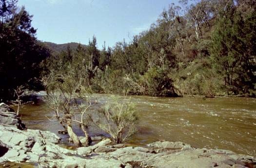
(southwest). The park includes the catchments of Silent Creek and the Retreat River
as well as 42 kilometres of the Abercrombie River.
The geology represents a gradual change from Ordovician metasediments - typical of
the southern tablelands (in the east), to Ordovician - Silurian metasediments on the
western edge which are typical of the central western slopes (NPWS, 1999). There is
a progression of older to younger rock sequences from east to west through the park,
resulting in soil changes from Orange loam to heavier loams (NPWS, 1999).
The soils are mainly skeletal, highly so on some western ridges and less on the
slopes (i.e. Gravel and coarse sands). Major drainage lines represent areas of
alluvial soils.
2.3 Biodiversity
The large altitudinal range and diverse geology of the park supports a unique variety
of fauna and flora. Vegetation ranges from that typical of the Central Tablelands in
the east, to the low altitude open forest species typical for the Central Western
Slopes in the western sectors of the park.
10Abercrombie River National Park Fire Management Strategy
Map 1 - Location of Abercrombie River National Park
Abercrombie River National Park
NSW
$
r
R ive
t
R etrea
ABERCROMBIE RIVER e
k
e
ic king Cr
L
H ol e Cre ek ie
s
av
NATIONAL PARK
D
ek
re k
e a Riv er
t C ree
S ilen
T a ve rn C
eek
Cr
t
et r
s
'Pond
R
inO
ha
k
Si lent Cree C
Sile nt Cre ek
N
LEGEND
Study Area 0 2 4 6 8 10 Kilometres
Road
River
Scale 1:185,000
Fire Trail
11Abercrombie River National Park Fire Management Strategy
Generally species diversity increases in areas where there is a large range in
geology types and altitudinal range. For example slopes around the ‘Governor’s Flat’
(western) area of the park possess a greater species diversity than those areas
around the Silent Creek area (east) (NPWS, 1999).
Abercrombie River National Park conserves a diversity of vegetation communities
typical of montane areas, tableland areas and western slopes. The area contains the
largest remaining intact patch of low open forest, open woodland and woodland in the
region and hence is very significant in species conservation within the area.
The continued presence of the Booroolong Frog (endangered, Schedule 1) in the
riparian areas of the Retreat River and the downstream, western (Governors Flat)
portion of the Abercrombie River, despite the apparent decline in it’s range is of
conservation significance.
2.3.1 Flora
2.3.1.1 Communities
A vegetation survey of Abercrombie River National Park, conducted by the
Comprehensive Regional Assessment (CRA) unit of the NPWS, determined 16
distinct plant communities that exist within the Park. These vegetation communities
are described below in Table 1 and illustrated in Map 2.
Table 1
Vegetation Communities In Abercrombie River National Park
Community Species Characteristics Area % of Determining Factors
of the Community (ha) Total
Area
(53) Riparian Acacia Casuarina cunninghamiana 226.91 1.20 Riparian areas of permanent
Shrub/Grass/Herb Forest watercourses at lower
altitudes.
(66) Tablelands E. radiata / E.dalrympleana / 46.03 0.24 Sheltered areas at high
Shrub/Grass Moist Forest Poa sieberiana / Daviesia altitudes (>850m). North
ulicifolia boundary of park.
(67) Northern Plateaux E. fastigata / E. dalrympleana 25.87 0.14 Sheltered riparian areas
Moist Fern/Herb/Grass /Acacia melanoxylon / above 1000 metres.
Forest Pteridium esculentum
(68) North East E. radiata / E.viminalis / 33.89 0.18 Southeast aspects with
Tablelands Shrub Lomandra longifolia altitude above 850m. Around
/Herb/Grass Dry Forest Little Bald Hill.
(89) Eastern Tablelands E. dalrympleana / E. viminalis / 848.98 4.49 Higher altitude (above
Acacia/Herb/Grass Forest Acacia melanoxylon / Stellaria 650m) riparian areas.
pungens
(90) Northern Tablelands E. bridgesiana / Acacia 1732.49 9.16 Poorer quality riparian areas.
Acacia Herb/Grass Dry dealbata / Hydrocotyle laxiflora Western areas of the park
Forest (younger loams).
(96) Tableland Tussock E.pauciflora / E.dalrympleana / 20.36 0.11 Sheltered SE aspects above
Grass/Herb Forest Poa sieberiana 1000 meters. NE of park,
Hackets Gully area.
(109) Tablelands Dry E. dives / E. mannifera / E. 3633.11 19.21 Slope areas above 600
Shrub/Tussock Grass macrorhyncha / Hibbertia meters. Eastern areas of the
Forest obtusifolia / Chionochloa park (older loams).
pallida
(112) Eastern Tablelands E. sieberi / E. dives / 804.86 4.26 Ridge areas above 600
Dry Shrub Forest Brachyloma daphnoides / Poa meters. Eastern areas of the
sieberiana park (older loams).
12Abercrombie River National Park Fire Management Strategy
Map 2 - Vegetation Communities Within Abercrombie River National Park
ad
A e Ro
on
Ar ks t
be
r cr
om
b ie
Ri
ve r
ad
Ro
u rn
Ab
lb
ou
er c
G
r
om
n-
b ie
O be ro
Ri v e
r
0 1 2 3 4 5 6 Kilometres N
Ea stern Tablelan ds Acacia /Herb/Grass Fo rest LEGEN D
Rip arian Acacia Shrub/Grass/Herb Fore st
Ea stern Tablelan ds Dry Shrub Fore st
Tableland Tusso ck Grass/Herb Fore st
North East Ta blelands Dry Shrub /Grass Fore st
Tablelands Dry Shrub/Tussock Grass Forest
North East Ta blelands Shrub/Herb /Grass D ry Fo rest
Tablelands Dry Shrub/Tussock Grass Forest
North ern Plateaux Moist Fern/H erb/Grass Forest
Tablelands Shrub /Grass M oist Fore st
Northern Slop es Dry Grass W oo dland
Western Slopes Grass/He rb D ry Fo rest
Northern Slop es Dry Grass W oo dland
No D ata
Northern Tablelan ds Acacia Herb/Gra ss Dry Forest
Park Bound ary
Northern Tablelan ds Grass Forest o n Basa lt
Roa ds
Northern Tablelan ds Shrub/Tussock Gra ss Forest Fire Trail
River
13Abercrombie River National Park Fire Management Strategy
Table 1 Cont.
Vegetation Communities In Abercrombie River National Park
Community Species Characteristics Area % of Determining Factors
of the Community (ha) Total
Area
(113) North East E. mannifera / E. dives / 6.13 0.03 Ridges above 800 meters
Tablelands Dry Brachyloma daphnoides / around Chain O Ponds
Shrub/Grass Forest Dianella revoluta Creek.
(114) Tablelands Dry E.macroryncha / E.rossii / E. 6755.21 35.71 Gravel and coarse sandy
Shrub/Tussock Grass goniocalyx / Chionochloa ridges and slopes. Younger
Forest pallida loams (SW of park)
(121) Western Slopes E. macrorhyncha / E. 4017.73 21.24 Gravel and coarse sandy
Grass/Herb Dry Forest goniocalyx / Gonocarpus ridges. Younger loams (SW
tetragynus / Poa sieberiana of park)
(149) Northern Tablelands E. dalrympleana 47.95 0.25 Ridges above 1000 meters.
Shrub/Tussock Grass Northeast area of park (older
Forest loams).
(159) Northern Slopes Dry E. blakelyi / E.bridgesiana / 436.8 2.31 Steep slopes with alluvial
Grass Woodland E.melliodora / Aristida ramosa soils. West area of park
(young loams).
(160) Northern Slopes Dry E. blakelyi / E. melliodora / 46.08 0.24 Lower altitude (Abercrombie River National Park Fire Management Strategy
Table 2
Rare or Threatened Australian Plant (ROTAP) Species Located within
Abercrombie River National Park
Species Growth Form and Habitat Conservation Response to Fire
Requirements Status
Leptospermum Shrub 1m high. Grows in Not currently Regenerate after fire from
blakelyi heath on rocky reserved within its seed (storage on plant) and
escarpments near Lithgow natural distribution. from rootstock (lignotuber).
(Harden, 1991). Status - Rare (2R )
Table 3
Regionally Significant Flora Species Located Within the Park
Species Growth Form and Habitat Conservation Response to Fire
Requirements Status
Argyle Apple Tree to 15m high. Grows in Status - Protected Regenerate after fire from
grassy or sclerophyll woodland northern limit of seed (on plant), rootstock
Eucalyptus to open forest on shallow distribution. (lignotuber) and aerial buds
cinerea relatively infertile soils from Namadgi NP (epicormic buds).
Sofala (North) to Tumut (Abercrombie River National Park Fire Management Strategy
2.3.2 Fauna
Throughout Abercrombie River National Park there has been several fauna surveys
undertaken by Charles Sturt University (CSU) students, the National Parks
Association (NPA) and the NPWS.
These surveys have concluded that there is a wide range of native fauna inhabiting
the park including 15 threatened species and 8 Regionally significant species.
The results of these surveys reveal that the majority of arboreal species were
associated with co-dominant Eucalypt communities associated with E. rossii, followed
by E. dives and E. macrorhyncha respectively (NPWS, 1999).
There has been numerous mammal species recorded, including 4 species that are
listed under the Threatened Species Conservation Act, 1995. Over 30 species of
reptiles have been recorded including 1 Vulnerable (Schedule 2) species,
Rosenberg’s Goanna (Varanus rosenbergi).
There have been 10 frog species listed including continued presence of the
endangered Booroolong frog (Schedule 1) in the riparian areas of the Retreat River
and the downstream, western (Goveners Flat) portion of the Abercrombie River.
ARNP has been found to be important habitat for at least 90 native bird species
including 2 threatened species, and several species with local conservation concern.
Also the Abercrombie River and its tributaries provide habitat for 3 fish species which
are considered regionally rare.
Table 4 lists those species that are listed under the TSC Act 1995, whilst Table 5 lists
those species within the Park that are considered to be of regional significance.
Table 4
Threatened Fauna that Occur or are Likely to Occur Within
Abercrombie River National Park
Species Preferred Habitat Potential Fire Effects Status
Koala Inhabits both wet & dry High intensity fires lead to Status -
Phascolarctos eucalypt forests on high removal of feed trees. Unaffected Vulnerable
cinereus nutrient soils containing by low to medium intensity fires
preferred feed trees. (ie hazard burns). Habitat
Present
Spotted-tail Quoll Dry and moist open forests Frequent fire can directly reduce Status -
Dasyurus containing rock caves, prey numbers. Frequent low Vulnerable
maculatus hollow logs or trees. intensity burns may reduce habitat
quality of prey species. Highest
population's known from long
unburnt sites (Dickman & Read,
1992). Avoid fire over large areas Habitat
of the Park. Present
Eastern False Inhabits sclerophyll forests. Felling of known roost trees and Status -
Pipestrelle bat They prefer wet habitats direct impact of medium to high Vulnerable
Falsistrellus where the trees are more intensity fires should be avoided,
tasmaniensis than 20m high. Prefer in order to maintain habitat trees.
hollow trunks of eucalypt
trees, caves and old
wooden buildings for Resident
roosting.
Common Bent- Prefers areas where there Frequent fires near roosting Status -
Wing Bat are caves, old mines, old habitat may impact upon Vulnerable
Miniopterus buildings, stormwater breeding success. Foraging
schreibersii drains & well timbered areas affected.
areas. Habitat
16Abercrombie River National Park Fire Management Strategy
Present
Rosenberg’s Hawkesbury sandstone Fires should not burn entire Status -
Goanna outcrop specialist. Inhabits habitat areas, as this species Vulnerable
Varanus woodlands, dry open needs refuge areas. Termite
rosenbergi forests and heathland mounds could also be impacted
sheltering in burrows, by fire, reducing habitat quality.
hollow logs, rock crevices Resident
and outcrops.
Booroolong Frog Associated with rocky Alteration in water quality may Status -
Litoria flowing streams in influence survival of tadpole Endangered
booroolongensis mountainous regions. larvae. Habitat removal by fire
unlikely. Predation may increase
in disturbed areas. Resident
Masked Owl Open forest & woodlands Frequent fires reduce breeding Status -
Tyto with cleared areas for success, otherwise habitat is Vulnerable
novaehollandiae hunting and hollow trees or maintained by fire.
dense vegetation for Habitat
roosting. Present
Powerful Owl Forests containing mature Frequent fires can directly Status -
Ninox strenua trees for shelter or reduce prey numbers. Frequent Vulnerable
breeding & densely low intensity burns may reduce
vegetated gullies for habitat quality of prey species.
roosting. Resident
Glossy Black Open forests with Frequent fire in vegetation Status -
Cockatoo Allocasuarina species and communities containing Vulnerable
Calyptorhynchus hollows for nesting. Allocasuarina species can
lathami remove foraging habitat. Resident
Square-tailed Kite Utilises mostly coastal and Frequent fires can directly reduce Status -
Lophoictinia isura sub-coastal open forest, prey numbers. Frequent low Vulnerable
woodland or lightly intensity burns may reduce habitat
timbered habitats and quality of prey species.
inland habitats along
watercourses and mallee Habitat
that are rich in passerine Present
birds.
Australasian Inhabits shallow freshwater Any fire in habitat can temporarily Status -
Bittern or brackish wetlands with damage habitat quality. Vulnerable
Botaurus tall dense beds of reeds,
poiciloptilus sedges or rush species Habitat
and swamp edges. Present
Black Bittern Freshwater & brackish Any fire in habitat can temporarily Status -
Ixobrychus streams & ponds. damage habitat quality. Vulnerable
flavicollis
Habitat
Present
Pink Robin Found in dense gullies, Frequent fires, especially low Status -
Petroica rainforests and open intensity autumn burns, may Vulnerable
rodinogaster forests, dispersing into reduce the amount of invertebrate
drier more open habitats in feed supplies available during Habitat
winter. winter. Present
Swift Parrot Inhabits eucalypt forests Intense fires causing tree Status -
Lathamus discolor and woodlands with winter damage may reduce or interrupt Vulnerable
flowering eucalypts. winter flowering of some eucalypt
species. Habitat
Present
Turquoise Parrot Inhabits coastal scrubland, Frequent fire may reduce Status -
Neophema open forest and timbered number of low nesting hollows Vulnerable
pulchella grassland, especially such as logs, stumps and posts
ecotones between dry preferred by this species.
hardwood forests and Habitat
grasslands. Present
17Abercrombie River National Park Fire Management Strategy
Table 5
Regionally Significant Fauna Species Located Within the Park
Species Preferred Habitat Potential Fire Effects Status
Diamond Python Shelters in hollow trunks and Low intensity fires unlikely to Status -
Morelia spilota limbs, disused burrows, affect the lifecycle of this Regionally
ssp. spilota caves, rock crevices and species. High intensity fire will Significant
beneath boulders. Often found kill individuals and remove
on rafters and ceilings of sheltering and foraging
buildings. habitat. Open to predation
following disturbance.
Resident
Gippsland Water Usually encountered on Unlikely to be significantly Status -
Dragon waterside rocks, logs or affected by fires. Frequent Regionally
Physignathus overhanging branches along fires will modify habitat Significant
leseuerii ssp. the margins of creeks, rivers quality. Open to predation in
howitti and lakes on coast, ranges disturbed areas.
and hinterland of eastern
Australia. Resident
Grey Goshawk Inhabits rainforests, forests, Frequent fires will modify Status -
Accipiter forest gullies and valleys, habitat, affecting prey Regionally
novaehollandiae taller woodlands, timber on numbers. Intense fires can Significant
watercourses and open remove nesting trees.
country in autumn dispersal. Resident
Peregrine Falcon Frequents cliffs, gorges, Frequent fires will modify Status -
Falco peregrinus timbered watercourses, and habitat, affecting prey Regionally
environs of rivers, wetlands, numbers. Intense fires can Significant
plains, open woodlands, remove nesting trees.
pylons, spires and buildings. Resident
Macquarie Perch Occurs in lakes and flowing Burning has the potential to Status -
Macquaria streams, usually in deep increase nutrients and Regionally
australasica holes. Sometimes seen in turbidity within waterways. Significant
large shoals near shore. Long term modification of
water quality may influence Resident
respiration and breeding
success.
Inhabits clear flowing streams Burning has the potential to Status -
River Blackfish with abundant cover. Also increase nutrients and Regionally
Gadopsis found in lakes and reservoirs. turbidity within waterways. Significant
marmoratus Long term modification of
water quality may influence Resident
respiration and breeding
success.
Silver Perch Inhabits rivers and large Burning has the potential to Status -
Bidanuss tributaries, also lakes and increase nutrients and Regionally
bidyanus reservoirs. Seen in turbidity within waterways. Significant
aggregations near the surface Long term modification of
in open water frequently below water quality may influence Resident
rapids and weirs. respiration and breeding
success.
Murray Cray Occurs in both large rivers Unlikely to be affected by Status -
Euastacus and minor streams in the modification in water quality Regionally
armatus tributaries of the Murray- and hence fire activities. Significant
Darling system.
Resident
2.3.3 Introduced Flora and Fauna
Some introduced flora and fauna are considered detrimental to Abercrombie River
National Park by being evasive, directly competing with or preying upon native
species. Introduced species may also effect soil and water systems and the
recreational, cultural and scientific values of the park.
18Abercrombie River National Park Fire Management Strategy
Currently there are three introduced flora species and six vertebrate pest species of
concern inhabiting the Abercrombie River National Park Area, these species are;
Serrated Tussock (Nassella trichotoma), Blackberry (Rubus fruiticosa), Willow
species, Feral Goats, Feral Pigs, Wild dogs, Fox (Vulpes vulpes), Cats and Rabbits.
Consideration must be given to the impacts of fire management prescription on
introduced species. Prescribed burning has the potential to increase invasive flora,
and increase exposure and predation of native fauna species.
2.4 Cultural Heritage
Cultural heritage includes all Aboriginal heritage sites and all historic places,
including buildings and other works together with pertinent contents and surroundings
which are valued by us and society and possibly future societies.
2.4.1 Aboriginal
Intense artefact surveys have been conducted within the Macks Flat area and the
Sink, The beach and Silent Creek Camping Areas. It is presumed that ARNP would
have once been a tribal area for the Gundungurra and/ or Wiradguri Aboriginal
Nations. Evidence in the form of chert cores and flakes have been found in areas of
permanent water, in particular the Macks Flat area and along the Abercrombie and
Retreat rivers (concentrated where the Retreat river meets Licking Hole Creek and in
gentle spur areas).
Protection of Aboriginal sites, from fire management activities, will be maintained
through applying Operational Guidelines. Research should be conducted to
comprehensively map areas of Aboriginal Heritage.
2.4.2 Historic
Abercrombie River National Park has not been systematically surveyed for Historic
Sites. Historic structures that remain in the park are associated with gold mining,
grazing, and recreational purposes, they include stock holding structures
(abandoned), various huts associated with recreational use, mine workings (including
a disused tunnel to divert the course of the Retreat River) and water races.
Protection of unknown and known historic sites, from fire management activities, will
be maintained through applying Operational Guidelines. Research should be
conducted to map areas of Historic Heritage.
2.5 Recreational Use and Facilities
Abercrombie River National Park has been used for recreational pursuits for at least
50 years, including fishing, canoeing, camping, swimming and four wheel driving. The
major camping areas are situated at the following locations;
• Bummaroo Ford, on the Abercrombie River along the Abercrombie Road
• Silent Creek, on the Silent Creek
• The Beach, on the Abercrombie River
• The Sink, on the Retreat River
Facilities at some of these sites include; pit toilets, fire rings, information/
interpretative displays and barriers to protect natural qualities. Visitation to ARNP in
19Abercrombie River National Park Fire Management Strategy
the past has been low, the comparative isolation of the park from urban areas and
the popularity of walking areas in the nearby Blue Mountains, probably contributed to
this low level of use.
There is now increasing visitation in the Park due to its mention in NPWS brochures,
4WD books and Magazines. Busy periods include school holiday times particularly
Easter and the October long weekend.
20Abercrombie River National Park Fire Management Strategy
3. BUSHFIRE ENVIRONMENT
Fire is an important part of the Australian environment. It can bring about a sudden
change to an ecosystem affecting both the structure and species composition.
Fire is also an important mechanism in regenerating plant species / communities as
many native plants are dependent on fire for survival. However in some instances,
fire can seriously damage native plant communities, diminish fauna habitat and
threaten human life and property. The key to effective fire management is the use of
fire regimes that enhance biodiversity and provide protection of assets.
3.1 Fire History and Frequency
Historically the incidence of wildfire in the Oberon district is low (OBFMC, 1999). Little
information is available on the occurrence of fire within Abercrombie River National
Park. Accurate medium to long term fire records (10-25+ years) have not been well
documented.
To date, only one wildfire has been accurately recorded and mapped within the Park.
This fire occurred in February 1999 and impacted 9872.1 hectares of the Park. A
large fire (3900 hectares) in 1985 occurred to the north of the park within the Jeremy
area. All other fire records within the Park are purely anecdotal and accuracy of detail
is unknown.
3.1.1 Unplanned Fires
Until 1995, Abercrombie River National Park was managed by Forests NSW
(Formerly State Forests of NSW). This area has a history of wildfires, which are
typically ignited by lightning activity. Major wildfires have occurred on these lands in
the following years; 1942, 1944, 1957, 1962/ 3, 1985, 1999 (BFMC, 1997, Pers.
Comm. BFMC, 1999).
Prior to 1999 the most significant wildfire event in the area was the 1985 ‘Jeremy’ fire
which was driven by south westerly winds and destroyed fences, stock, rural
dwellings and plantation forests. The ‘Crookwell’ wildfire at the beginning of 1999
(17/2/99) could be considered a very significant wildfire event affecting the park, with
approximately 52% of the parks vegetation affected. Map 3 illustrates the available
wildfire history within the Park.
Specific weather patterns have been observed affecting the area. Of most concern to
fire management, is the existence of a lightning corridor running along the east-west
section of the Abercrombie River from Wyangala Dam. This lightning activity has
been observed as being very concentrated during El Nino periods.
21Abercrombie River National Park Fire Management Strategy
22Abercrombie River National Park Fire Management Strategy
23Abercrombie River National Park Fire Management Strategy
3.1.2 Prescribed Burning
Prescribed burning is a tool used under specified environmental and weather
conditions to attain planned resource management objectives. For example, fuel
reduction for asset protection. Prescribed burning can also help reduce the intensity
of a wildfire and provide for suppression advantage.
Recorded prescribed burn history for Abercrombie River National Park is limited. The
previous manager of the land, Forests NSW, conducted a number of prescribed
burns within the Park. Records for these burns have been passed onto NPWS and
have been compiled in Map 4. These prescribed burns were carried out in 1987,
1992, 1993 and 1994. The NPWS have also conducted prescribed burns since the
establishment of Abercrombie River National Park. The extent of these burns have
also been compiled in Map 4. Prescribed burns were carried out by NPWS in 2004
and 2005.
Historically the majority of prescribed burning within the park has been conducted by
local residents, for both hazard reduction and stock grazing. In general these hazard
reduction burns have been conducted in Autumn along boundaries and ridgelines
with a regime of around 4 to 5 years, where the common practice is to ignite along
creeks and let to burn up slope. Fire of this nature are generally left to self extinguish
over night.
3.1.3 Fire Frequency
Fires within the Park are not well documented. Verbal accounts of previous wildfires
will be investigated, and if accurate can be included in future planning documents.
Two large fires have been recorded over the last 17 years. The first occurring in
1987, when Forests NSW conducted a prescribed burn. The second was a wildfire
during 1999. This information is useful when undertaking suppression activities and
planning hazard reduction burns. With information on fires limited to only a small
timeframe an accurate historical fire frequency guideline for the park can not be
made, but will continue to be accurately developed over time.
3.2 Fire Weather
Fire weather is the term used to describe the way climatic events affect bush fire
behaviour. Fire weather is also impacted by the shape and aspect of the physical
terrain e.g. west facing lands with a steep slope cause significant fire intensity to
occur.
Fire behaviour is assessed by the way a fire gains intensity and the way a fire’s rate
of spread can be increased. The use of climate indices such as air temperature,
rainfall, relative humidity and wind (both speed and direction) allow predictions of
likely fire behaviour.
If these factors are high during the bushfire danger period (usually October to
March) it can be expected that significant fire intensity may occur in areas where
hazardous fuels are located. Thus climatic conditions are a key feature in the
assessment of the bush fire behaviour potential.
Whilst the Bush Fire Danger Period extends from 1st October to 31st March, it is
sometimes brought forward or extended given the prevailing weather conditions.
These conditions may limit NPWS conducting prescribed burning activities.
24You can also read