Bray Municipal District Local Area Plan 2018 - May 2018 Wicklow County Council - including the settlements of - Bray Municipal District Local Area ...
←
→
Page content transcription
If your browser does not render page correctly, please read the page content below

Bray Municipal District
 Local Area Plan 2018
       including the settlements of
   Bray, Enniskerry and Kilmacanogue.

           May 2018
        Wicklow County Council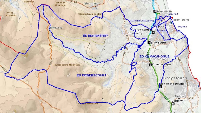
BRAY MUNICIPAL DISTRICT LOCAL AREA PLAN 2018

                    BRAY MUNICIPAL DISTRICT LOCAL AREA PLAN 2018-2024

TABLE OF CONTENTS

Written Statement                                                                      Page
CHAPTER 1           Introduction                                                       1
CHAPTER 2           Overall Vision & Development Strategy                              3
CHAPTER 3           Residential Development                                            23
CHAPTER 4           Economic Development & Employment                                  27
CHAPTER 5           Town / Neighbourhood Centres & Retail                              30
CHAPTER 6           Community Development                                              37
CHAPTER 7           Tourism & Recreation                                               40
CHAPTER 8           Infrastructure                                                     46
CHAPTER 9           Built & Natural Heritage                                           52
CHAPTER 10          Key Development Areas                                              57
CHAPTER 11          Zoning and Land Use                                                78

Maps
Map No. 1           Bray MD Boundaries Map
Map No. 2           Land Use Zoning Map- Bray Town & Environs
Map No. 3           Land Use Zoning Map- Enniskerry
Map No. 4           Land Use Zoning Map- Kilmacanogue

Map No. TO1         Transport Objectives Map
Map No. GI1         Green Infrastructure Map

Map No. H1        Heritage Objectives Map- Built Heritage
Map No. H2        Heritage Objectives Map- Natural Heritage
Map No. H3        Heritage Objectives Map- Bray Settlement Built Heritage
Map No. H4        Heritage Objectives Map- Bray Settlement Natural Heritage
Map No. H5        Heritage Objectives Map- Enniskerry Settlement Built Heritage
Map No. H6        Heritage Objectives Map- Enniskerry Settlement Natural Heritage
Map No. H7        Heritage Objectives Map- Kilmacanogue Settlement Heritage Map
Heritage Schedule and Record of Protected Structures

Appendices
A    Strategic Environmental Assessment
B    Appropriate Assessment
C    Strategic Flood Risk Assessment
D    Infrastructure Delivery Schedule & Implementation

                                                           Local Area Plan Adopted          14 May 2018
                                                           Local Area Plan Effective        10 June 2018

              This Local Area Plan shall be read in conjunction with the Wicklow County Development Plan.
BRAY MUNICIPAL DISTRICT LOCAL AREA PLAN 2018

                                      CHAPTER 1                  INTRODUCTION

1.1     Preamble

This is the Bray Municipal District Local Area Plan 2018 prepared pursuant to Section 20 of the Planning &
Development Act 2000 (as amended).

The purpose of this plan is to put in place a land use framework that will guide the future sustainable development of
the Bray Municipal District, which includes the settlements of Bray, Enniskerry and Kilmacanogue (as shown on Land
Use Map No. 1 appended to this plan). This plan, in conjunction with the County Development Plan, will inform and
manage the future development of the area.

Previously, the development plan for Bray Town was a stand-alone policy document, prepared under a process
separate to the Wicklow County Development Plan1. Previous Town Development Plans therefore were required to
include the entire suite of policies, objectives and development standards that would be relevant to and would apply
in the Bray Town Council jurisdiction. However, with the dissolution of the town councils, Wicklow County Council has
become the planning authority for Bray town and therefore the provisions of the Wicklow County Development Plan
now apply directly in Bray town2.

The development plans for the towns of Enniskerry and Kilmacanogue previously formed part of the County
Development Plan and those plans adopted in the 2016 County Development Plan are hereby superseded by this
Local Area Plan3.

The majority of policies, objectives and development standards that will apply in the Bray Municipal District are already
determined in the Wicklow County Development Plan and all efforts shall be made to minimise repetition of County
Development Plan objectives in this Local Area Plan, unless it is considered necessary to emphasise assets or restate
objectives that have particular relevance and importance to the area. While this will facilitate the streamlining of this
plan to just those issues that are relevant to this area, and an overall reduction in the content of the plan, this should
not be seen a diminution of the level of importance or indeed protection afforded to this area.

In particular, development standards, retail strategies, housing strategies etc that are included in the County
Development Plan shall not be repeated. Any specific policies / objectives or development standards required for this
area will be stated as precisely that, and in all cases will be consistent with the County Development Plan. Thus
development standards will therefore be the same across the entire County, and any differences for specific
settlements would be clear and transparent, to both those adopting the plans, and the general public alike.

Furthermore, this Local Area Plan shall only include objectives that are area specific and achievable, and avoid those
that are aspirational or are best dealt with in the annual budget, road works programme, etc. The role of land use
plan is to put in place a framework within which development can occur, but does not decide what works
actually get done by either private individuals or public bodies. The delivery of objectives will be determined by the
initiation of private development or by the allocation of public funding through the annual budgetary process, which is
a separate process to any land use plan.

This plan shall have a duration of 6 years, but has been framed with a longer horizon. In particular, residential land
zoning provisions have been made on the basis of providing enough housing land to meet the 2025 population and
housing target, in order to ensure that there is enough flexibility in the zoning provision to achieve the target in the
event that impediments to the development of certain lands arise.

1
   The ‘Town Development Plans’ prepared previously for Bray Town were prepared under Sections 11-12 of the Planning and
Development Act 2000 (as amended), as Bray Town Council was until 2014 a separate planning authority to Wicklow County Council.
2
  The provisions of the Wicklow County Development Plan already directly apply to all lands outside of the former Town Council
boundary, including the settlements of Enniskerry and Kilmacanogue.
3
  The County Development Plan has been varied as required to reflect this change
                                                             1
BRAY MUNICIPAL DISTRICT LOCAL AREA PLAN 2018
1.2     Plan format

The plan comprises a written statement and a series of maps that provide a graphic representation of the content of
the written text. Where there is any discrepancy between the text and maps, the text shall take precedence.

The plan is accompanied by a number of appendices – the plan Strategic Environmental Assessment, Appropriate
Assessment and Strategic Flood Risk Assessment. All of these documents have informed the crafting of the plan.

As a Local Area Plan, there is no requirement to set out a ‘Core Strategy’ for the development of the area covered in
the plan. However, Chapter 2 of the written document shall set out the factors on which the plan objectives are built,
that are consistent with the Core Strategy of the County Development Plan.

Thereafter the sections of the plan will set out the objectives of the plan under the following headings:
    - Residential development
    - Economic development and employment
    - Town / Neighbourhood centres & Retail
    - Community development
    - Tourism and recreation
    - Infrastructure
    - Built and natural heritage
    - Key development areas.

1.3      Maps

The maps provide a graphic representation of the written statement of the Plan. They indicate land use and other
development standards together with various objectives of the Council. The maps do not purport to be accurate
survey maps from which site dimensions or other survey data can be measured. Should any conflict arise between the
written statement and the map, the written statement shall prevail.

The plan relates to the functional area of Bray Municipal District. Parts of the built-up area of Bray are located in the
adjoining functional area of Dun Laoghaire-Rathdown County Council and the appropriate Development Plans
and Local Area Plans of DLR County Council govern development of these areas.

                                                            2
BRAY MUNICIPAL DISTRICT LOCAL AREA PLAN 2018

                 CHAPTER 2                OVERALL VISION & DEVELOPMENT STRATEGY

2.1     Vision

A key aim of a Local Area Plan is to set out the vision and development strategy for the future development of an area
and from this vision, all policies and objectives can be developed and implemented with the overall aim of achieving
this vision. The vision and development strategy must be consistent with the ‘Core Strategy’ of the County
Development Plan and reflect the characteristics, strengths and weaknesses of the area.

The vision for the Bray MD is:

                               For the Bray Municipal District to be a

            cohesive community of people enjoying distinct but interrelated
            urban and rural environments; where natural surroundings and

       important resources are protected; where opportunities abound to live
        and work in a safe atmosphere, allowing people to enjoy the benefits
      of well paid jobs, a variety of housing choices, excellent public services,
                             ample cultural and leisure opportunities,
                                       and a healthy environment.

This chapter will describe the key factors that have influenced this plan, for example the higher order plans and
strategies, as well as physical factors and the desired pattern of development, that have influenced the crafting of this
plan.

Local Area Plans exist in a hierarchy of plans flowing from national level (National Spatial Strategy / National Planning
Framework) to regional level (Regional Planning Guidelines for the Greater Dublin Area / Regional Spatial & Economic
Strategy) to County level (Wicklow County Development Plan). It is through the County Development Plan that these
higher order strategies, as well as other national and regional policies (e.g. relating to transportation and the
environment) are translated to a ‘local level’. The County Development Plan includes a ‘Core Strategy’ which sets out
the ‘direction’ for the future growth of the County, in accordance with these higher level strategies, and in particular
sets out the settlement and population growth strategy for the target years of 2022, 2025 and 2028, evaluates the
demand for housing and adequacy of zoned lands to meet those needs, as well as providing strategies for
infrastructure, environmental protection and retail development.

                                                           3
BRAY MUNICIPAL DISTRICT LOCAL AREA PLAN 2018
2.2     FACTORS INFLUENCING THE STRATEGY

2.2.1   Role and function of settlements in the Bray MD

                                                         BRAY

Bray is the largest town in County Wicklow, located in a strategically important position within the metropolitan area
and at the eastern gateway to the County. The town has the best transport links in the County, with access to the
N/M11 transportation corridor (including M50), DART/ rail line and quality bus service. It is a strong active town that
provides a higher order economic and social function for its local residents and for residents from other surrounding
towns and villages.

Further expansion of the town is severely constrained on all sides by the administrative boundary of Dun Laoghaire
Rathdown to the north, the coast to the east, Bray Head / Sugarloaf mountains to the south and the N/M11 to the
west. In order for Bray to achieve its targeted population, lands at Fassaroe to the west of the N/M11 are targeted for
new housing and other facilities. The development of a new centre at Fassaroe is largely dependent on the delivery of
infrastructure including upgrades to the N/M11 and the delivery of high quality public transport connections to Bray
Town Centre and to Dublin City Centre. Planned development in the Fassaroe area shall be required to avoid effects
on the integrity of Natura 2000 sites, particularly the Ballyman Glen SAC which forms the northern boundary of this
area. In addition, the town should continue to consolidate and to densify at suitable, albeit limited, locations in a
sustainable manner.

Bray forms part of the ‘Bray/Cherrywood/Greystones Core Economic Area’ (Regional Planning Guidelines for the
Greater Dublin Area 2010-2022). Bray should provide significant employment opportunities; while a significant number
of the town’s residents commute to Dublin for employment, the vision is for this trend to be reversed. The town has
potential to provide significant employment, not only for the residents of the town but should be drawing workers into
the town from other areas across the region. The RPGs indicate that the employment catchment of the town extends
as far as Wicklow, Arklow and Gorey. The town should aim to have a concentration of major employment generating
investment, particularly in the retail, services and industrial sectors. While the town would be attractive to all forms of
industry and investment types, the town should primarily aim to attract high value foreign investment, focusing mainly
on ‘people’ based industries at locations with easy access to public transport. Having regard to the limitations for
expansion of employment facilities within the town, there is scope for the creation of new facilities at Fassaroe.

The town has a role to play in the provision of all forms of higher order services and facilities, including for example,
high quality secondary and tertiary education services, a small hospital or polyclinic type facility, swimming pool,
athletics track, libraries, cultural and leisure facilities. In addition, the town should aim to become a major shopping
destination for comparison goods, attracting people from the surrounding towns and villages.

                                                            4
BRAY MUNICIPAL DISTRICT LOCAL AREA PLAN 2018

The town has the potential to be the most sustainable town in the County – a town which can most easily achieve the
vision of ‘walkable’ communities whereby residents have access to local services and facilities including employment,
shops, services, schools, playgrounds etc all within walking distance. In addition, all residents in the town have access
to a good quality public transport system with local buses and DART services, thereby reducing the dependence of
residents on private car use.

Bray Seafront and Bray Head draw a significant number of day trippers to the town. Protecting the heritage and
amenities of the town is particularly important if it is to continue attracting visitors into the future. There is scope to
improve the overall visitor experience through measures such as improving the quality of tourist services and facilities
and through measures that could improve the quality of the overall appearance of the town and seafront area,
including for example shopfront improvements.

                                                            5
BRAY MUNICIPAL DISTRICT LOCAL AREA PLAN 2018

                                                 ENNISKERRY

Enniskerry is identified as ‘Small Growth Town’ (Level 5) in the County settlement hierarchy. Such settlements are not
to be prioritised for major growth or investment but rather should be prioritized as attractors for more local
indigenous growth and investment. Such towns are ideally serviced by good bus or rail links and located
approximately 5-25km or so from large growth towns.

Relatively small and locally financed businesses are expected to locate in small growth towns. However other
economic investment could be supported where sustainable and in keeping with the size and services of the particular
town. These towns should target local investment in ‘product’ intensive industries with some ‘people’ emphasis. Retail
is likely to be mainly in the convenience category with a small supermarket and possibly local centres serving only the
town and its local catchment area. Small growth towns would likely contain facilities such as a primary and sometimes
a secondary school, as well as a health clinic.

                                                          6
BRAY MUNICIPAL DISTRICT LOCAL AREA PLAN 2018

                                               KILMACANOGUE

Kilmacanogue is identified as ‘Rural Town’ (Level 6) in the County settlement hierarchy. Level 6 towns are strong rural
towns, with a good range of infrastructural services. These towns are differentiated in this plan from ‘small growth
towns’ having regard to their more rural character and the rural nature of their catchments. Such rural centres are
considered to contain the potential to consolidate rural development needs and support the maintenance of essential
rural social and community infrastructure such as schools, shops, public houses, post offices and local sporting
organisations.

These settlements should aim to attract local investment, mainly in ‘product’ intensive industries with some ‘people’
intensive industries particularly within centres. There may be scope for these settlements to capitalize on opportunities
to provide tourism infrastructure and to tap into developments based on rural pursuits within the rural area.

These settlements are suited to accommodating a significant element of urban generated housing demand, with
necessary controls in place to ensure that local demand can also be met. As set out in the Sustainable Rural Housing
Guidelines (which are relevant to settlements under 1,500 in size, such as these towns), the NSS suggest that in
stronger rural areas the small town and village structure has much potential in accommodating additional housing
development catering for persons working in larger cities and towns, but desiring a rural lifestyle.

In these settlements it is essential that growth is supported while also strictly controlled so that development is
undertaken in a manner that is respectful to the character of these towns and the environmental sensitivities of the
rural area. It is of utmost importance to ensure that the design of development is appropriate to the rural setting
within which these towns are situated.

Kilmurray, an unstructured ‘hamlet’ of c. 30 houses south of the main core of Kilmacanogue, was previously identified
as a ‘Rural Cluster’ (Level 9) in the County settlement hierarchy. Due to its proximity to Kilmacanogue, it’s functional
and community links to Kilmacanogue, which is the main service centre for sports, schools etc for Kilmurray, and the
shortage of housing land in Kilmacanogue to meet Core Strategy housing targets, this plan expands the boundary of
Kilmacanogue to include the former cluster and the intervening land.

The key purpose of this expanded area is to facilitate low to medium density housing as allowed by the ‘tertiary zone’
designation, as well as some employment on existing employment lands (designated ‘secondary zone’).

                                                           7
BRAY MUNICIPAL DISTRICT LOCAL AREA PLAN 2018

                                                     RURAL AREA
The ‘rural area’ (i.e. any lands outside of a designated ‘settlement’) is an active and vibrant place that plays host to a
range of activities including, for example, rural housing, rural recreational activities, agricultural, horticulture, forestry,
aquaculture and fishing activities, rural tourism, rural enterprises, quarrying and extraction, landfill and energy
generation.

The key development parameter in the rural area is to facilitate appropriate and necessary activities and development,
but to protect the natural environment within which these activities are undertaken. Protecting the natural
environment is essential for the maintenance and protection of ecological biodiversity and landscape quality, as well as
meeting climate change and green infrastructure aspirations. In order to safeguard the future viability of rural activities
and to ensure that the rural area flourishes, it is essential that the development of the rural area is managed in a
sustainable manner into the future.

It is necessary to support and protect the rural area and ensure the appropriate management of rural uses including
rural housing, key rural services, agricultural activities, use of aggregate resources, green and alternative businesses,
rural transport, rural tourism and rural entrepreneurship.

Development within the rural area should be strictly limited to proposals where it is proven that there is a social or
economic need to locate in the area. Protection of the environmental and ecological quality of the rural area is of
paramount important and as such particular attention should be focused on ensuring that the scenic value, heritage
value and/or environmental / ecological / conservation quality of the area is protected.

                                                              8
BRAY MUNICIPAL DISTRICT LOCAL AREA PLAN 2018
2.2.2 Physical context
The key factors that will drive the development strategy for the Bray MD area are the physical context and
natural/manmade constraints of the area. In particular:
Bray
Bray is the most northerly town in County Wicklow, being located at the Dublin – Wicklow border, with parts of the
‘town’ actually being located in County Dublin. The town is only c. 17km south of Dublin city centre and forms part of
the ‘Dublin Metropolitan Area’.
The town developed initially around the castle built in the 12th century by Sir Walter de Ridelsford on a rocky
promontory (on what is now known as Castle Terrace) overlooking a strategic river ford on the Dargle. The initial
village grew up around the castle and adjoining oratory, with a mill and mill race being constructed along the river
below. Fishing boats and trading ships generally used the south bank of the river, between the town and the coast. In
time, development spread to the northern side of the river, a castle having been built on what is now Castle Street in
probably the 15th century.
Development over the next centuries was principally on higher lands on the southern river bank, the hub of maritime
activity, and further south along the main routes south towards Greystones and Kilmacanogue. The 18th and 19th
centuries saw the major growth of the town, with commerce in the form of brewing, distilling and milling taking over
from the traditional military and fishing role of the settlement. However, it was with the coming of the railway in 1854
(to principally support the burgeoning tourist industry) that saw Bray start to take its current form; the seafront
esplanade was developed, along the wide boulevards linking the town down to the station and coast, in particular
Quinsborough Road, with the development of stately mansions, villas, grand hotels and public institutions on the lands
between the Main Street and coast. Bray harbour was built in 1897.
Little Bray and Bray Commons, north of the river, underwent much more haphazard and piecemeal development up
until around the turn of the 20th century, when a programme of clearance of poorer cabins was commenced along with
the construction of model ‘artisan dwellings’ between Castle Street and Sunnybank.
Development in the latter half of the 20th century was principally focused on the lands between the town centre and
the seafront and to the west as far as the natural boundary formed by the Dargle River initially; with the construction
first of dual carriageway in the 1970s and then the M11 ‘Bray-Shankill bypass’ in 1991 ultimately forming a western
boundary to the development ‘envelope’. Other key events which have or will influence the spatial development of the
town include the development of the Bray southern cross road (SCR) in the mid 1990s which opened up significant
tracts of lands for range of housing, employment and community uses and the relocation of Bray Golf Club (in the
early 2000’s), which has left a large area of land vacant in the heart of the town.
In considering how and where to grow the town further, the historical development and physical limitations must be
recognised, namely:
Bray cannot grow to the north or north-west due to the County boundary or the east (sea);
Growth to the south-east is constrained by Bray Head and the SAAO / Natura 2000 designation;
Growth on the southern / southern western side must consider the historical Kilruddery Demesne, the Little
Sugarloaf and the desire to maintain a ‘break’ between the built up areas of Bray and Kilmacanogue;
Growth of the town to west of the N11 is feasible, but must take cognisance of existing access points across the
N11 and the maintenance of a ‘break’ between Bray and Enniskerry;
The existence of only one bridge in the town centre, as well as the location of M11 junctions and primary access
routes in to the town.
The key parameters for development are based around environmental protection (in particular to identify which key
natural and built assets to protect given the pressure for development), sustainability and developing the town in a
manner that would generate the minimal number of car journeys and maximum use of public transport.
9BRAY MUNICIPAL DISTRICT LOCAL AREA PLAN 2018
The solution adopted in this plan has a number of elements:
As the majority of the lands in the town4 are ‘built out’ and very few ‘greenfield’, ‘brownfield’ or vacant sites
remain, all such possible sites have been identified and re-evaluated in this plan, to achieve the maximum level
of infill development possible in the town core; for example with respect to new housing, the plan provides that
35% of all new housing is targeted to occur on such sites, including 1,000 units on the former Bray golf club;
The development of a major new centre at Fassaroe, west of the M11, targeted to be developed as a mixed
residential, open space, community and employment area, with the potential to meet up to 60% of the new
housing need of the settlement;
To designate a small area of Kilruddery Demesne for additional development, for residential and employment
uses.
Enniskerry
Enniskerry is a picturesque settlement located 22km south of Dublin city centre, 5km west of Bray and approximately
2.5km west of the N11/M11, which links Dublin to Rosslare. The settlement is situated at the head of the wooded
Cookstown River Valley between the Glencullen and Dargle Rivers, within the foothills of the Sugarloafs, and the
Wicklow-Dublin Mountains.
The compact settlement of Enniskerry is an estate town laid out around a triangular market place containing a clock
tower dating back to 1843. Landscape plays a large part in the town’s character and development. In the second half of
the 20th century the settlement began to extend northwards into the Monastery area and westwards into the Kilgarron
area, with Knocksink Wood and the Bogmeadow area remaining in their natural green form. The release of land from
part of the Powerscourt Demesne allowed the construction of the “Eagle Valley” development south of the settlement
in the 1990s. Development has generally not occurred in an eastward direction due to the topography of this area and
the alignment of the R117, which generally limits the construction of new entrances. The settlement is surrounded in
three directions by an undeveloped agricultural belt to the north, east and west, with Powerscourt Demesne providing
a natural green area to the south.
Enniskerry is located in a valley area surrounded by higher ground in all directions. The settlement is served with a
network of roads radiating in all directions from the town centre. The settlement is principally served by the R117,
which links the settlement to the N11/M11, and continues across Enniskerry Bridge in a northwards direction towards
The Scalp, Kiltiernan and south County Dublin. South of the settlement is served by the R760 and R755 to
Kilmacanogue with local road L1010 to the west to Glencree. The Dargle River runs south of Enniskerry with the
Glencullen River flowing north of the historic settlement, through Enniskerry Bridge. The County Development Plan
categorises the landscape surrounding Enniskerry in all directions as an Area of Outstanding Natural Beauty.
In deciding how the town should develop there are many options given the fashion of its spatial development history.
Again the key parameters however, must be based on environmental protection, sustainability and developing the
town in a manner that would generate the minimal number of car journeys. The solution adopted in this plan is to
designate residential lands as close as possible to the town centre and existing community facilities whilst avoiding the
environmentally sensitive and EU designated areas (Knocksink Wood and Ballyman Glen are both SACs), with new
employment being located on existing zoned land to the west of the settlement.
In recognition of the above this plan has aimed to consolidate the existing built pattern in Enniskerry by maximising
the potential of large sites close to the settlement core and any infill sites along the main roads within the settlement.
The designation of specific lands for residential development has been provided in a manner that facilitates greater
connectivity between the settlement core and the existing developed lands within the plan area. Sufficient lands have
been zoned in order to meet the projected population targets as set out in the Core Strategy of the County
Development Plan.
4
By ‘town’ the former area within the ‘Town Council’ boundary is meant
10BRAY MUNICIPAL DISTRICT LOCAL AREA PLAN 2018
Kilmacanogue
The town of Kilmacanogue is located at the junction of the R755 to Roundwood and the N11, 5km south of Bray town
centre. Kilmacanogue is located equidistant between the Little Sugar Loaf to the east and the Great Sugar Loaf to the
west, in the north eastern foothills of the Wicklow Mountains. The town itself is named after. St. Mochonog who was
an early Irish saint with strong associations with Glendalough. The location of the town at the foothills of the Great
Sugar Loaf Mountain makes it a popular destination for recreational users.
The town of Kilmacanogue is spread out, with no real definition in terms of a town core and over the years the N11
has come to dominate the town. The properties on the east side of the N11, which includes some residential and
employment properties and a service station, have become somewhat cut-off from the majority of services, which are
located on the west side of the N11. The pedestrian link bridge over the N11 and the vehicular flyover are important
links to connect the two sides of the town.
Existing services in the primary lands on the west side of the N11 comprise a post office, service station, public house,
church, two crèches and primary school. The ‘Avoca Handweavers’ outlet and the business park to the north of the
settlement are a popular destination for tourists, locals and those travelling on the N11. While these facilities are all in
close proximity and together would form the basis for a town ‘core’, the dominance of the N11 and associated
roundabouts / slip roads has hindered the development and improvement of this core area and has impacted on town
‘identity’.
In light of these factors the key aim of this plan is to consolidate the town; to encourage the development of
commercial and community development in the core, particularly that which can contribute towards creating a more
defined ‘town centre’ and town streetscape; and to allow for the development of housing on infill, rather than out of
centre, sites.
2.2.3 Population and Housing
The population of the Bray MD in 2016 was 35,530 persons, showing a slight increase of 3.5% from the 2011
population (34,335). This Municipal District is made up 7 ‘electoral divisions’ and the population is broken down as
follows:
Table 2.1 Population of Bray MD and associated Electoral Divisions 2006, 2011 and 2016
2006 2011 2016 2016 Housing Stock
Bray No. 1 1700 1746 1845 837
Bray No. 2 6305 6192 6410 2622
Bray No. 3 6557 6424 6481 2659
Rathmichael (Bray) 2431 2380 2418 850
Kilmacanogue 13772 14043 14694 5031
Enniskerry 2696 2765 2894 990
Powerscourt 773 785 788 301
Total 34,234 34,335 35,530 13,290
Source: CSO
11BRAY MUNICIPAL DISTRICT LOCAL AREA PLAN 2018
Map 2.1 Bray MD Electoral Divisions
As well as providing data at the MD and ED geographical unit, the CSO also provides the result expressed in units such
as ‘legal towns’, ‘towns and their suburbs / environs’ and ‘small areas’.
Town data
Bray
Table 2.2 Population of Bray ‘town - 2006, 2011 and 2016
2006 2011 20165
Bray (legal town) 27,041 26,852 -
Bray & suburbs / environs (in Wicklow) 28,814 28,592
Bray & suburbs / environs (Wicklow + DLR) 31,901 31,872
Bray (new 2016 boundary defined) 32,600
Map 2.2
2016 CSO definition of boundaries of ‘Bray’
5
With regard to the 2016 figure, the CSO states the following: ‘80 legal towns were abolished under the Local Government Reform
Act 2014. Census towns which previously combined legal towns and their environs have been newly defined using the standard census
town criteria (with the 100 metres proximity rule). For some towns the impact of this has been to lose area and population, compared
with previous computations’.
12BRAY MUNICIPAL DISTRICT LOCAL AREA PLAN 2018
Enniskerry
Table 2.3 Population of Enniskerry ‘town’ - 2006, 2011 and 2016
2006 2011 2016
6
Enniskerry town 1881 1811 1889
Map 2.3
2016 CSO definition of boundaries of ‘Enniskerry’
Kilmacanogue
Table 2.4 Population of Kilmacanogue ‘town’ - 2006, 2011 and 2016
2006 2011 2016
Kilmacanogue town7 839 1028 1042
Map 2.4
2016 CSO definition of boundaries of ‘Kilmacanogue’
Estimates of 2016 population, based on plan boundaries
Each ED is broken into a number of smaller units, called ‘small areas’. It is not considered necessary to display this level
of detail in this plan, but the data provided by the ‘SAPS’ are essential for estimations of current population in each of
these settlements, as none of the ED or ‘town’ boundaries and associated population data aligns with the town
boundaries used in this LAP.
Using the ED and SAPS data (taking a ‘best fit’ approach8), and cross referencing it with the GeoDirectory, the
estimated 2016 populations of each settlement in the plan area is:
Table 2.5 2016 Population and Housing Stock in Bray MD area, by settlement
Bray Enniskerry Kilmacanogue9 Rural Area
2016 Population 29,624 1,889 934 3,230
2016 Housing Stock 11,225 640 374 1,051
Source: Forward Planning Unit, WCC
6
‘Town’ as defined by the CSO
7
‘Town’ as defined by the CSO
8
That is, using that set of SAPS that most closely match each settlement boundary in this plan
9
Extended Kilmacanogue boundary including Kilmurray
13BRAY MUNICIPAL DISTRICT LOCAL AREA PLAN 2018
Population & Housing growth targets
The 2022, 2025 and 2028 population targets for the settlements in the Bray MD are provided in the Core Strategy of
the County Development Plan – the County Development Plan does not provide a target for the overall MD or for rural
areas.
Table 2.6 Population Targets for settlements in Bray MD – 2022, 2025 and 2028
Settlement 2022 2025 2028
Bray 36,237 38,119 40,000
Enniskerry 2,302 2,401 2,500
Kilmacanogue10 1,012 1,038 1,065
Source: Wicklow County Development Plan 2016
As set out in the Wicklow County Development Plan, it is never possible to manage growth in any particular settlement
to come in at an exact population figure at a set time, which is 2028 for the purposes of the County Development Plan.
As development in 3 of the 6 growth towns in the County, representing towards 35% of the projected County growth,
is reliant on the cooperation and financing of Transport Infrastructure Ireland (formerly National Roads Authority and
the Railway Procurement Agency), as is the case in Bray, or Irish Water (as is the case in Arklow and Blessington), it is
not possible to make accurate predictions. The town population allocations set out above have thus incorporated
‘compensatory headroom’ of 15% to accommodate this uncertainty and to ensure that there will be sufficient capacity
in other settlements if some growth towns are unable to deliver the necessary infrastructure to service their projected
populations.
While this plan will have a duration of 6 years initially, the provisions of the Planning Act allow in certain circumstances
for the duration of local area plans to be extended to 10 years. It is considered likely that between 2018 and 2022
(date of the next County Development Plan) that the population targets for the County and this MD will be revised in
light of the findings of Census 2016 and the provisions of the new National Planning Framework (NPF)11 and the
Regional Spatial and Economic Strategy (RSES). In this uncertain context, it is considered appropriate at this stage that
the plan shall put in place a structure to meet the short term 6 year target only, with 1 year ‘headroom’. “Headroom” or
“market factor” which is ‘extra’ land that is zoned over and above the minimum amount needed to accommodate the
2024 population target. Headroom is provided so as to allow for greater location choice and deal with any land supply
inflexibility which may arise. Therefore the population and housing unit targets for 2025 are utilised in this plan.
Table 2.7 Housing Stock growth target up to 2025 in Bray MD area, by settlement
Bray Enniskerry Kilmacanogue Rural Area
2016 Population 29,624 1,889 934 3,230
2016 Housing Stock 11,225 640 374 1,051
2025 Housing target 17,651 1,112 481 -
Growth 6,426 472 107 -
This plan includes details regarding the capacity of zoned lands for housing. The estimated potential number of
additional units indicated for each piece of land is indicative only. The actual amount of units that may be permitted on
a site will be determined having regarded to all normal planning considerations, such as access, site services,
topography, flooding, heritage issues etc. However, in accordance with Objective HD5 of the County Development
Plan, in order to make best use of land resources and services, unless there are cogent reasons to the contrary, new
residential development shall be expected to aim for the highest density indicated for the lands.
10
Including Kilmurray
11
The draft NPF was published during the adoption of this plan
14BRAY MUNICIPAL DISTRICT LOCAL AREA PLAN 2018
RESIDENTIAL DEVELOPMENT STRATEGY FOR BRAY MD
To adhere to the objectives of the Wicklow County Development Plan in regard to population and housing as are
applicable to Bray MD;
To ensure sufficient zoned land is available at appropriate locations capable of meeting the housing needs of the
targeted population of the settlements in the MD over the plan period in a sustainable manner. Notwithstanding
the zoning of land for residential purposes, the Planning Authority shall monitor and implement the population
targets as set out in the County Development Plan and shall phase and restrict, where necessary, the granting of
residential planning permissions to ensure these targets are not exceeded;
To promote and facilitate in-fill housing developments, the use of under-utilised / vacant sites and vacant upper
floors for residential use and facilitate higher residential densities at appropriate locations, subject to a high
standard of design, layout and finish;
To promote and facilitate the redevelopment of sites in town centres, including identified opportunity sites, where
development will positively contribute to the commercial and residential vitality of the town centre;
To promote and facilitate the rapid delivery of the maximum number of housing units in the key development areas
of Fassaroe and the former Bray golf club.
2.2.4 Economic Development and Employment
Depending on their degree of accessibility and their economic function, the settlements within the Bray MD area have
varying roles to play in acting as attractors for foreign and local investment. Level 5 and 6 settlements generally
perform a lesser function in terms of attracting investment than Level 1-4 settlements, however these settlements
perform an important role in attracting local investment and should aim to target investment in the form of local
services, ‘product intensive’ industries, particularly those linked to rural resources, such as food processing, agricultural
services and tourist facilities / accommodation.
The factors that make a town economically viable and attractive to investors and visitors are numerous and often hard
to predict and influence, but for the purpose of this land use plan, the strategy for economic development will be
based around (a) providing a land-use framework for the settlements in the MD which makes the Council’s
requirements and expectations with respect to the location and type of new development abundantly clear, (b)
supporting and facilitating, to the highest degree possible (subject to environmental and other relevant planning
considerations) all forms of employment generation appropriate to the MD, (c) protecting and enhancing the heritage
and environment of the MD including historic street pattern and buildings / features of heritage and environmental
value and (d) encouraging a varied mix of uses in the core town / village areas.
An established measure of the employment ‘health’ of a settlement is a measure called the ‘jobs ratio’. This is the
relationship between the number of people in the labour force and the number of jobs in any defined area. A healthy
area is considered to be one where the jobs ratio is around 70%. The County Development Plan sets out an objective
to increase the average ‘jobs ratio’ in the County to c. 60% in 2028 (from a 2011 rate of 42%). Not all towns / areas will
of course be able to reach this level and it is considered reasonable that the plan should aim to increase the jobs ratio
proportionately in each area according to its characteristics and level in the County settlement / employment
hierarchy.
15BRAY MUNICIPAL DISTRICT LOCAL AREA PLAN 2018
For the Bray MD it is an objective to increase the jobs ratio in the three settlements between 2011 and 2028 as follows:
Settlement JR 2011 JR 2028 Jobs 2028 Growth 2011-2028
Bray 55% 83% 13,832 6,154
Enniskerry 22% 33% 415 209
12
Kilmacanogue 94% 118% 492 130
The objectives of this LAP, in particular the land zoning provisions, will support the achievement of this quantum of
jobs growth. It is acknowledged that the timeframe of 2028 is longer than the housing growth timeline of 2025, but it
is considered appropriate to have a longer term framework in place for employment given the priority attached to this
land use and the pressure all land banks may be under in the future for housing delivery.
In order to ensure the land use framework can deliver such new employment creation, the solution adopted in this
plan has a number of elements, as set out below.
ECONOMIC DEVELOPMENT AND EMPLOYMENT STRATEGY FOR BRAY MD
To build on the Bray MD’s distinctive qualities to develop a dynamic, regionally competitive economy that
creates wealth and provides quality sustainable work opportunities for all the residents of the district;
To encourage in the first instance, job creation in the existing town centres, in retail and retail services,
professional services, tourism, accommodation;
The encourage and facilitate the change of use of existing non-commercial properties in the town core to
commercial or employment uses, particularly small to medium size enterprises and start ups;
To ensure sufficient zoned land is available in appropriate locations capable of facilitating the development of
appropriate employment opportunities in accordance with the provisions of the County Development Plan.
Maintain existing, developed employment lands and resist changing the zoning or use of such sites, particularly
to residential uses, except where local conditions can justify same. In such limited circumstances, employment
providing development may still be required as part of the package of development including residential;
To target that at least 50% of the required jobs growth in any town shall be in the town centre or existing
developed employment sites and thereafter, to zone lands for new employment creation at the most optimal
locations;
Facilitate the provision of key infrastructure required for the future development of enterprise and employment;
Promote a high quality built and natural environment that is attractive to indigenous and foreign industry and
employees;
To facilitate the development of opportunities to capitalise particularly on the district’s coastal location;
To prioritise the existing town centres as the core location for more intensive economic activity and job creation;
Promote tourist developments at suitable locations that are of an appropriate scale and design, particularly
developments that are linked with the tourism products or themes associated with the Bray MD and its
hinterland and maximise the towns in the district’s locations as both destinations and gateways between other
nearby tourism assets;
For Bray, the key location for new employment development shall be in Fassaroe, where it is the objective to
secure the delivery of up to 3,000 new jobs.
12
The jobs ratio for Kilmacanogue is exceptionally high and this is due to (a) the small population and associated force of the town,
compared to (b) the high number of jobs available in the town, particularly boosted by Avoca Handweavers. This figure should not
be taken to suggestion that everyone living in Kilmacanogue is in employment.
16BRAY MUNICIPAL DISTRICT LOCAL AREA PLAN 2018
2.2.5 Town Centres and Retail
It is the vision of the Council that every resident, visitor and worker within County Wicklow shall have access to a range
of quality retail goods within the county, and that these goods shall be provided within town and village centre areas
that are vibrant places to be in and viable places to do business.
This vision shall be realised through the implementation of the following key strategic objectives:
to expand the level of convenience floorspace within the County, to meet the convenience shopping needs of
existing and future residents up to 2031;
to reduce leakage of expenditure from County Wicklow to other counties, through a significant expansion in the
amount and range of comparison floorspace within the County, which will provide for a significant amount of
the comparison shopping needs of existing and future residents up to 2031;
to enable each centre to perform in accordance with its role and function as identified in the Retail Hierarchy
and to allow a healthy level of competition between centres whilst ensuring that the role and function of each
centre is not undermined;
to promote and encourage the major enhancement of retail floorspace, primarily comparison goods and town
centre functions in Bray, to sustain its competitiveness and importance as a Consolidation Town within the GDA;
to promote the expansion of retail floorspace first and foremost within the core retail areas / existing town and
village centre areas and thereafter in accordance with the sequential approach to retail development;
to ensure that town and village centres are attractive places to live in, to work in and to visit, easy to get to, easy
to walk and cycle within and are competitive places to conduct business; and
to promote a high quality of design in all centres.
TOWN CENTRE AND RETAIL STRATEGY FOR BRAY MD
To promote and encourage consolidation of and improvement to retailing and other town centre activities in the
core areas of the three towns in the district including the renovation and expansion of existing retail premises in
the core retail area;
Encourage the redevelopment and regeneration of vacant, underutilised and derelict sites including the
conversion of non-retail premises in the core area to retail use;
To protect features that contribute to the towns’ overall appearance and heritage value;
To encourage higher residential densities in the town centre zones and the concept of ‘living over the shop’;
The redevelopment of lands within the town core area, particularly those sites with frontage onto the main
streets and squares of the towns, shall provide for a street fronting building of a high quality design or for a high
quality urban space, including hard and soft landscaping, and appropriate street fixtures and furniture, in order
to enhance and create a more attractive streetscape.
TOWN CENTRE & RETAIL STRATEGY FOR BRAY
It is the vision that Bray will become a major destination for shopping and in particular for medium and higher quality
comparison goods. Shoppers within the town shall have access to a range of quality leisure and cultural activities
provided within the core retail area. This centre should provide a full range of all types of retail services from
newsagents to specialist shops and boutiques, department stores, foodstores of all types, shopping centres and a high
level of mixed uses including the arts and culture, to create a vibrant, living place. The centre should be well connected
and served by high quality public transport.
This centre provides for the ‘big shop’ convenience needs of its residents and other settlements in the vicinity
including Enniskerry, Kilmacanogue and Shankill. The centre has the opportunity to provide for the comparison
shopping needs of a much wider catchment beyond its more immediate environs, particularly extending south and
north to other settlements along the N11.
17BRAY MUNICIPAL DISTRICT LOCAL AREA PLAN 2018
Having regard to the above, it is the priority of the Planning Authority to:
promote and encourage the major enhancement of retail floorspace, primarily comparison goods and town
centre functions in Bray to sustain its competitiveness and importance as a Consolidation Town and leisure
destination within the GDA;
facilitate the significant expansion in the amount and range of comparison floorspace, particularly floorspace for
middle and higher order comparison goods;
to facilitate the delivery of a large scale retail development within the core retail area on the Florentine
Development site;
to facilitate the delivery of a large scale retail development on the former Golf Club Lands; and
to facilitate the extension of the LUAS to Bray.
Bray seafront area shall be a vibrant and attractive seafront area, which functions as the primary tourist, recreational
and leisure centre of the town. It is a priority to rejuvenate the seafront area through the expansion of retail and non-
retail services, particularly targeted at the visitor market and tourism products. The town centre is located some
distance from the seafront area and does not benefit from spin-off associated with the uptake of leisure activities on
the seafront. Taking account of this, it is of major importance that the centre carves out a significant role for itself in
the provision of quality shopping facilities which act as a draw for people into the centre.
Bray is well connected by a high quality public transport system, centred at the Bray DART Station. The town suffers
severe traffic congestion at times. While improvements have been made to make the central area more pedestrian
friendly, the town could benefit from further improvements. It is a priority of the Planning Authority to facilitate
development that contributes to the improvement of the overall appearance of the area around Bray Railway Station,
to increase the density and mix of uses in this area and to provide clear pedestrian/cyclist links between this area and
the town centre and seafront area. This area is the gateway and transportation hub of this major town and the general
appearance, aesthetic appeal and range of uses promoted in this area should be reflective of this significant role.
The quality of shopfronts within Bray Main Street and surrounding side streets is relatively poor. In addition, some
parts of the centre have suffered from high degrees of vacancy. It is a priority of the Planning Authority to facilitate
development that would contribute to the improvement of the overall appearance and aesthetic appeal of the
streetscape, including for example shopfront improvements, regeneration of vacant sites and public realm
improvement schemes.
Within the expansion area of Fassaroe, the Planning Authority will facilitate the provision for the development of
appropriately scaled retail provision, which provides for the immediate needs of residents and employees of the area
but does not undermine the role of Bray town centre as the principal shopping destination in the settlement.
The Planning Authority will allow for the development of a new appropriately scaled neighbourhood centre on the
Southern Cross Road, to provide for the day to day needs of residents and employees of the area but does not
undermine the role of Bray town centre as the principal shopping destination.
Indicative additional floorspace allocations (net m²):
Bray: Convenience 7,000m², Comparison 30,000-35,000m²
Fassaroe: Convenience 2,500m², Comparison 1,000m²
The RPG Retail Guidelines indicate that well established centres with population catchments in excess of 60,000 people
would be expected to have a volume of retail floorspace in excess of 40,000m². Bray currently has approximately
35,000m² of net retail space (including vacant units). While the level of additional floorspace allocated to Bray is
significant, Bray is better positioned to expand its comparison retail offer than a number of settlements lower down in
the hierarchy and is the Metropolitan Consolidation Town in the County and therefore it is considered appropriate to
allow for substantial growth. The above allocation aims to expand the volume of retail floorspace to c. 77,000m². This
is reasonable, having regard to the size of other level 2 centres, e.g. Dundrum c. 82,000m², Blanchardstown c.78,000m².
18BRAY MUNICIPAL DISTRICT LOCAL AREA PLAN 2018
While the target population and retail catchment of Fassaroe is more akin to a Level 3 centre (5,000-15,000 people), it
is envisaged that Fassaroe will provide the function more akin to a Level 4 Neighbourhood Centre. This is in order to
ensure that the area does not undermine the role of Bray town centre as the principal shopping destination in the
settlement.
RETAIL STRATEGY FOR NEIGHBOURHOOD CENTRES IN BRAY
A neighbourhood centre comprises a small group of shops, typically comprising newsagent, small supermarket /
general grocery store, sub-post office and other small shops of a local nature serving a small, localised catchment
population. The function of a Neighbourhood Centre is to provide a range of convenient and easily accessible retail
outlets and services within walking distance for the local catchment population. Neighbourhood centres generally only
occur in the larger settlements of the County, e.g. Bray, Wicklow, Arklow and Greystones, at a location within the
settlement boundary but remote from the core retail area.
The designated ‘Neighbourhood Centres’ in this plan are:
- Vevay Road
- Southern Cross Route
- Fassaroe
TOWN CENTRE & RETAIL STRATEGY FOR ENNISKERRY
The commercial core of Enniskerry extends around the clock tower with a mixture of shops, cafes, public houses and
other businesses. The town centre has a relatively strong street frontage and core for urban activity with residential,
commercial and community functions taking place side by side. It is important that town centres are inhabited, provide
for a mix of uses and exhibit a high standard of urban design, in order to ensure vitality and viability.
Given Enniskerry’s retail function as envisaged by the County Retail Strategy and having regard to the significant
leakage of expenditure from the settlement due to the close proximity to a number of high order retail centres
(notably Bray, Greystones and Dundrum), it is considered there is a need to further develop and enhance the retail
offer in the town, particularly with regard to convenience shopping. It is important that new developments, particularly
in the ‘Town Centre’ zone respect the existing scale of the development in the settlement and have regard to the
architectural conservation area designation.
TOWN CENTRE & RETAIL STRATEGY FOR KILMACANOGUE
As a Level 6 settlement, it is the strategy to create a consolidated and vibrant mixed use settlement centre that is the
focal point for the delivery of the retail, commercial, community and activity needs of the local population and its
hinterland, and to promote this area for tourist uses and for residential use, with an animated and high quality
streetscape, whilst ensuring the protection of the special character and heritage of this area.
To support existing uses and facilitate the development of new uses that will improve the vitality, connectivity
and vibrancy of the primary lands;
To promote the development of a range of retail outlets, including a variety of small scale convenience and
comparison outlets in accordance with the County Retail Strategy and shops to provide for the tourist market
(i.e. ‘tourist retail’);
To promote these lands for the development of ‘people’ intensive employment generating developments,
including retail, tertiary services, commercial developments, office, civic, institutional and tourist uses;
All shopfronts shall be of traditional design with strict adherence to the use of traditional materials;
To promote the use of upper floors for ‘Living over the Shop’ and office accommodation.
The objectives of this LAP, in particular the land zoning provisions, will support the achievement of this quantum of
retail floor space development.
19You can also read