FINAL BURNABY TOWN CENTRE STANDARDS
←
→
Page content transcription
If your browser does not render page correctly, please read the page content below
FINAL

                        BURNABY
                 TOWN CENTRE STANDARDS

                    Supported by:
                                    PARSONS
September 2020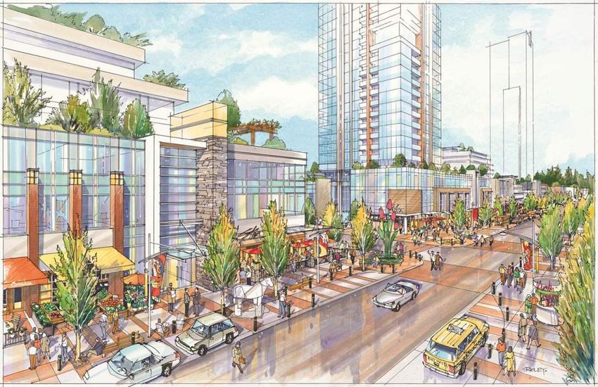
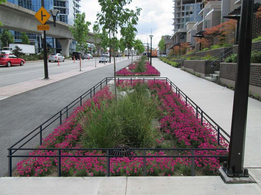
Table of Contents

1     VISION AND OBJECTIVES...................................................................................................................................................... 1
    1.1      VISION........................................................................................................................................................................... 1
    1.2      BACKGROUND .............................................................................................................................................................. 1
    1.3      DESIGN PRINCIPLES .................................................................................................................................................... 2
    1.4      SCOPE ........................................................................................................................................................................... 3
    1.5      OTHER RELEVANT DOCUMENTS ................................................................................................................................. 3
2     TOWN CENTRE OBJECTIVES ................................................................................................................................................ 5
    2.1      FOUR TOWN CENTRES................................................................................................................................................. 5
    2.2      STREETSCAPE ZONES ................................................................................................................................................. 7
      2.2.1          Building Setback Zones ...................................................................................................................................... 9
      2.2.2          Walking Zone .....................................................................................................................................................10
      2.2.3          Centre Boulevard ..............................................................................................................................................10
      2.2.4          Cycling Zone ......................................................................................................................................................11
      2.2.5          Front Boulevard .................................................................................................................................................12
      2.2.6          Vehicular Zone and Parking .............................................................................................................................13
    2.3      IMPLEMENTATION .....................................................................................................................................................13
3     TOWN CENTRE DESIGN CRITERIA .....................................................................................................................................19
    3.1      STREET TYPOLOGIES .................................................................................................................................................19
      3.1.1          Typical Six-Lane Arterial Street .........................................................................................................................20
      3.1.2          Typical Four-Lane Collector and Arterial Street ...............................................................................................20
      3.1.3          Typical Two-Lane Collector Street ....................................................................................................................21
      3.1.4          Typical Two-Lane Local Street ..........................................................................................................................21
      3.1.5          Perimeter Street ................................................................................................................................................21
      3.1.6          Custom Street ...................................................................................................................................................23
    3.2      TRANSPORTATION DESIGN CONSIDERATIONS ........................................................................................................23
      3.2.1          Road Geometry .................................................................................................................................................23
      3.2.2          Intersection Geometry ......................................................................................................................................25
      3.2.3          Transit Accessibility and Stops .........................................................................................................................26
      3.2.4          Driveways ..........................................................................................................................................................26
      3.2.5          Sidewalks ..........................................................................................................................................................26
      3.2.6          Sidewalk and Cycle Track Mixing Areas ...........................................................................................................27

    Burnaby Town Centre Standards                                                                                                                                                        i
3.3      CYCLE TRACK CONSIDERATIONS ..............................................................................................................................27
      3.3.1          Cycle Tracks on Steep Slopes ..........................................................................................................................27
      3.3.2          Cyclist Accommodations at Intersections ........................................................................................................27
      3.3.3          Additional Considerations .................................................................................................................................29
    3.4      UTILITY CONSIDERATIONS.........................................................................................................................................29
      3.4.1          Utility Alignments...............................................................................................................................................29
    3.5      RAINWATER MANAGEMENT AMENITY DESIGN CONSIDERATIONS .........................................................................30
      3.5.1          Design Specifications .......................................................................................................................................31
      3.5.2          Stormwater Management Design Considerations ..........................................................................................32
      3.5.3          Rainwater Management Amenities Design .....................................................................................................32
    3.6      STREET LIGHTING DESIGN CONSIDERATIONS .........................................................................................................32
      3.6.1          Pedestrian Activity .............................................................................................................................................33
      3.6.2          Security ..............................................................................................................................................................33
      3.6.3          Codes, Rules, Standards and Permits .............................................................................................................33
      3.6.4          Roadway and Pedestrian Conflict Classifications ...........................................................................................34
      3.6.5          Light Sources .....................................................................................................................................................34
      3.6.6          Intersection Lighting .........................................................................................................................................34
      3.6.7          Poles ..................................................................................................................................................................35
    3.7      ACCESSIBILITY ...........................................................................................................................................................36
4     STREETSCAPE COMPONENTS ...........................................................................................................................................37
    4.1      PAVING MATERIALS ...................................................................................................................................................38
    4.2      VARIATIONS BETWEEN TOWN CENTRES ..................................................................................................................39
    4.3      LANDSCAPE FURNISHINGS .......................................................................................................................................39
    4.4      PLANTING PALETTE ....................................................................................................................................................41
      4.4.1          Planting Palette .................................................................................................................................................41
      4.4.2          Volumes .............................................................................................................................................................42
      4.4.3          Soil Composition ...............................................................................................................................................42
      4.4.4          Irrigation ............................................................................................................................................................43
5     OPERATIONS AND MAINTENANCE .....................................................................................................................................45
    5.1      HARDSCAPE TREATMENTS........................................................................................................................................45
    5.2      ELECTRICAL ................................................................................................................................................................46
    5.3      STREET FURNITURE ...................................................................................................................................................46
    5.4      RAINWATER MANAGEMENT AMENITIES AND LANDSCAPING TREATMENTS .........................................................47

    iiBurnaby Town Centre Standards                                                                                                                                    Proposal Titleii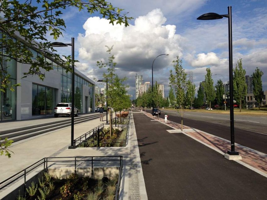
Appendices
Appendix A – Town Centre Standard Drawings
Appendix B – Landscape Planting Palette Reference Table
Appendix C – Preliminary Design Report Requirements for Rainwater Management Amenities

Figures
Figure 1 – Burnaby Town Centres
Figure 2 – Streetscape Zones Four-Lane and Six-Lane Streets
Figure 3 – Streetscape Zones Two-Lane Streets
Figure 4 – Brentwood Town Centre Implementation Area
Figure 5 – Metrotown Town Centre Implementation Area
Figure 6 – Lougheed Town Centre Implementation Area
Figure 7 – Edmonds Town Centre Implementation Area
Figure 8 – Typical Six-Lane Arterial Street Section
Figure 9 – Typical Four-Lane Collector and Arterial Street Section
Figure 10 – Typical Two-Lane Collector Street Section
Figure 11 – Typical Two-Lane Local Street Section
Figure 12 – Typical Six-Lane Perimeter Street Section
Figure 13 – Two-Lane Collector Street Visualization

Tables
Table 3-1 – Two-Lane Local Road Geometry Specifications
Table 3-2 – Two-Lane Collector Road Geometry Specifications
Table 3-3 – Four-Lane Collector and Arterial Road Geometry Specifications
Table 3-4 – Six-Lane Arterial Road Geometry Specifications
Table 3-5 – Maximum Ratio of Impervious Drainage Area to RMA Surface Area
Table 3-6 – Intersection Lighting Design Criteria
Table 4-1 – Clay Brick Paver Colour Palettes by Town Centre
Table 4-2 – Growing Medium Composition Specification
Table 4-3 – Structural Growing Medium Composition Specification
Table 4-4 – Micronutrient Specifications for All Growing Mediums
Table 5-1 – Routine Maintenance Activities for Hardscape Treatments
Table 5-2 – Routine Maintenance Activities for Electrical
Table 5-3 – Routine Maintenance Activities for Street Furniture
Table 5-4 – Routine Maintenance Activities: Rainwater Management Amenities and Landscaping

   iii
   Burnaby Town Centre Standards                                                             Proposal Title
                                                                                                         iii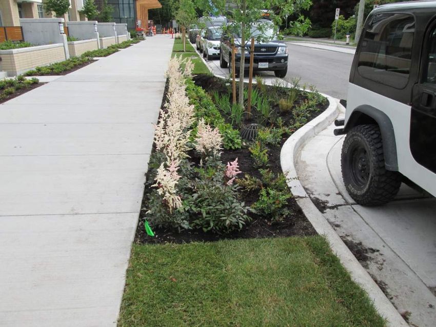
1 Vision and Objectives

1.1 VISION

Four Distinct Town Centre Characters, One Coherent Vision
It is an exciting time for the City of Burnaby, as well as a most appropriate time to enhance the public realm to accommodate
current populations and future projected populations that are being attracted to the City. A high-quality public realm is
essential to achieving an attractive neighbourhood experienced at the human scale. It can encourage people to use
sustainable transportation modes - walking, cycling, transit - by offering improved connections between places, and making
those connections into memorable spaces themselves. It can nurture community by providing gathering spaces that are
appealing and functional.

The public realm plays an important role in enhancing the quality of life in a community, which, in turn, can improve its
desirability as a place to live, work, and play. To achieve these benefits, the Town Centre Standards outlines a
comprehensive and strategic approach to how the public realm is developed, enhanced and maintained.

The intent of this document is to create a “kit of tools” for each of the four Town Centres by making them coherent yet
unique and special at the same time. Although these guidelines are meant to provide a basis to create a cohesive
streetscape throughout Burnaby, these landscape typologies have also been designed with the idea of flexibility in mind.
As populations grow and demographics change, so do community needs and demands. Thus, the public realm should be
designed for not only the City it is today, but the City it has the potential and vision to be in the future. As such, this document
takes a fine-grained approach to the City’s four town centres that defines a high-level standard for each of the public realm
design elements.

1.2 BACKGROUND
Enhancements to the quality of the Town Centre public realm provide an opportunity to advance a broad range of the City’s
economic, social, and environmental goals. Accordingly, this report presents the public realm design standards that have
arisen from Council’s adopted policies for Burnaby’s four Town Centres. A primary impetus for developing the design
standards for the Town Centres was Council’s adoption of the Supplementary Community Benefit Bonus Density Policy in
November 2010.
This policy calls for “additional community amenities to support and service residents and businesses within the Town
Centres” with the goal of “enhancement of the livability of the City and its Town Centres.” The Town Centre public realm
design standards arise from that direction. Council’s adoption of the Beresford Art Walk concept in 2010 provided a starting
point for the design standards, the evolution of which has continued since that time.
The Burnaby Town Centre Standards will integrate pedestrian, cyclist, and transit elements to be used by City of Burnaby
Staff, Developers, Design Engineers, and Property Owners to meet the community’s objectives for sustainable and resilient
redevelopment of the public realm within each Town Centre. On 2015 January 14, Council instructed staff to develop and
implement the new standards.

   Burnaby Town Centre Standards                                                                                               1

1.3 DESIGN PRINCIPLES
                                                              The development of the Town Centre
                                                              Standards for the Four Town Centres in
                                                              Burnaby has been guided by a clear set of
                                                              Design Principles. These will continue to
                                                              provide   a    guiding   framework    for
                                                              implementation of the standards over the
                                                              years ahead.

                                                                       1                Re-create the “living room”

                                                              Streets can be the “living room” of a community, where
                                                              people can gather, socialize, and share urban living. The
                                                              design standards seek to create streets as places for
                                                              people.

                                                                       2
          Photo 1: Lougheed Highway, Brentwood Town Centre
                                                                                        Attractive

                                                              The public realm designs strive to be more appealing and
                                                              interesting, thus encouraging people to use these spaces,
                                                              and enhance the attractiveness of the surrounding
                                                              community.

                                                                       3                Build Complete Streets

                                                              They are streets on which travel feels safe and comfortable
                                                              regardless of physical ability, gender, or choice of mode.

                                                                       4                Emphasize Local Community

                                                              Neighbourhoods should emphasize and capitalize on their
                                                              local community’s unique demographics, history,
                                                              inspiration, and potential, with the goal of creating public
           Photo 2: Beresford Street, Metrotown Town Centre
                                                              spaces that promote people’s health, happiness, and
                                                              well-being.

                                                                       5                Enhance the Environment

                                                              The designs can improve the quality of water discharged
                                                              into our streams and reduce the rate of runoff entering
                                                              local streams. They improve air quality through the use of
                                                              broad-canopy street trees and by promoting low-emission
                                                              transportation.

                                                                       6                Efficient Use of Space

                                                              Road allowance is one of the City’s most valuable assets,
                                                              comprising 20% of Burnaby’s total area. As public space,
                                                              it can be used to achieve multiple City goals. Public realm
                                                              designs can provide for superior landscaping, a more
                                                              natural treatment of rainwater, and more space for people
            Photo 3: Telford Avenue, Metrotown Town Centre    while still accommodating vehicle travel.

 2
 Burnaby Town Centre Standards                                                                           Proposal Title
                                                                                                                      2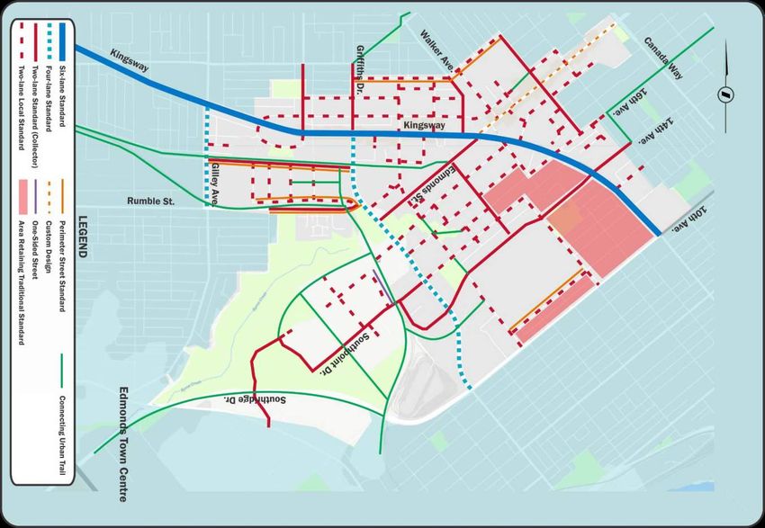
1.4 SCOPE
The Burnaby Town Centre Standards provide the minimum standards to be used for design of road projects in Burnaby’s
Town Centres. This document is to be used in conjunction with documents listed in Section 1.5. Standard drawings and
specifications contained in this report are developed to ensure consistency in design criteria, materials, layout and
dimensions for each applicable location.
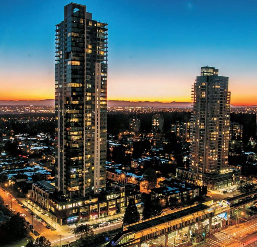
Burnaby has four Town Centres (refer to Figure 1):
1. Brentwood
2. Metrotown
3. Lougheed
4. Edmonds
Initial visions for these Town Centres began in 1971, followed by the adoption of individual town centre plans that built on
earlier studies, with the Metrotown Town Centre Plan in 1977, the Edmonds Town Centre Plan in 1994, the Brentwood
Town Centre Plan in 1996, and lastly the Lougheed Town Centre Plan in 1997. A new Metrotown Plan was adopted in
2017. In conjunction with the Official Community Plan in 1998 and relevant concepts derived from recent development
plans and strategies, the Town Centre Standards document aims to consolidate and give shape to public realm objectives
that include:
• Improving Safety, Access, Environment, and Aesthetics for all.
• Environmental, Social, and Economic Sustainability.
• Define Priorities and use Design Standards.
• Create Spaces that are Enjoyable and Safe for Intended Users as well as Others.
• Accessibility for all Ages and Abilities.
With recent redevelopment occurring within the Town Centre areas and significant redevelopment planned in the future,
this document focuses on the consolidation of prior concepts, moving forward from lessons learned through early
developments, and applying the latest innovative design practices to develop a unified set of design criteria.
1.5 OTHER RELEVANT DOCUMENTS
In addition to the documents cited in Section 1.4, other City policies and development regulations that are relevant and
should be reviewed include:
• City of Burnaby Design Criteria Manual.
• City of Burnaby Supplemental Specification and Detail Drawings.
• Burnaby Transportation Plan, 2004.
• Economic Development Strategy, 2007.
• Beautification Strategy, 2007.
• Social Sustainability Strategy, 2011.
• Environmental Sustainability Strategy (ESS), 2016.
• Transportation Association of Canada (TAC) Design Documents.
• National Association of City Transportation Officials (NATCO) Design Documents.
3
Burnaby Town Centre Standards Proposal Title
3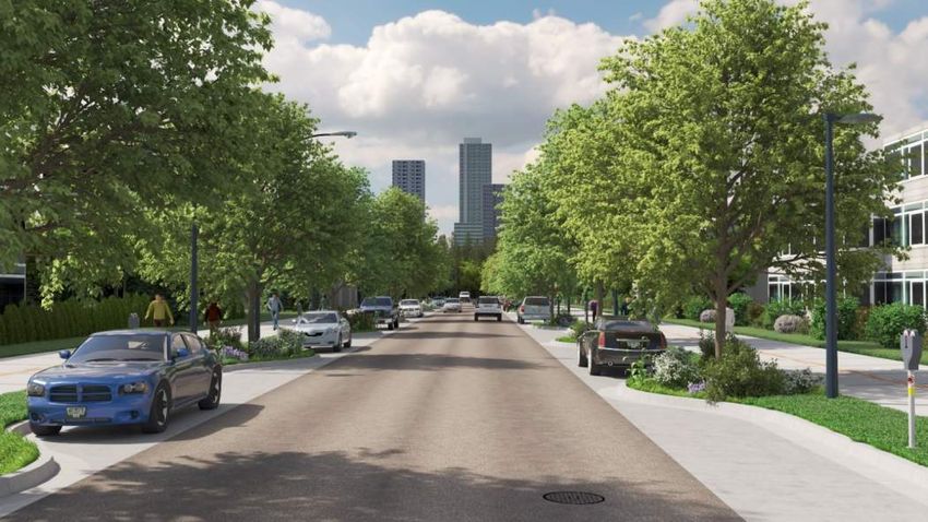
Figure 1 – Burnaby Town Centres

4
Burnaby Town Centre Standards                                     Proposal Title
                                                                               4
2 Town Centre Objectives
2.1 FOUR TOWN CENTRES
Burnaby has four Town Centres, including a Regional City Centre (Metrotown) and three Municipal Town Centres
(Brentwood, Edmonds, and Lougheed). All four town centres are comprised of a mix of office, retail, supportive professional
services, public and institutional land, and high-density housing opportunities. Each town centre will be building upon a
common set of design principles and design guidelines, yet, each will strengthen its own identity through use of subtle
variations such as unique hardscape colour palettes.
To better understand the specific character of each of these Town Centres, here is a summary of key feature and elements
for each of them:
Metrotown
Metrotown is prominently located on the Kingsway Ridge in the southwest quadrant of Burnaby. The boundaries are
generally defined by Boundary Road and Central Park to the west, Royal Oak Avenue to the east, Imperial Street to the
south, and a varied northern boundary including Bond and Dover Streets. The Plan area totals 735 acres and is currently
home to approximately 25,000 residents. To the north and south of the Plan area are established single-and two-family
neighbourhoods. To the east is the Royal Oak Community Plan Area, and to the west is the City of Vancouver.
Metrotown is the geographic centre of the Metro Vancouver Region. As such, it has seen significant investment in regional-
scale infrastructure and transportation, City-wide services and amenities, and offers superior connectivity to other major
urban centres throughout the Region.
The area is also a transportation hub in that it is directly served by two SkyTrain stations (Patterson Station and Metrotown
Station) and related bus routes and exchanges, with Metrotown Station being one of the most highly used stations in the
network. The Royal Oak Station is located further southeast in close walking distance to the Metrotown area. In addition to
Metrotown’s many parks and open spaces, one of the area’s main attractions is Central Park, which is both a city and
regional destination for sport, cultural and leisure activities.
Metrotown is a premier centre of business, culture, and social activity. As a Regional City Centre, it serves not only the
people who live in the community, but also people from all over Metro Vancouver and visitors alike.
Brentwood
Located in Burnaby’s northwest quadrant, Brentwood is sited on a south facing slope in the heart of the Central Valley
containing Still Creek and Burnaby Lake, which divide Burnaby north and south. The boundaries of the town centre are
generally defined by the lane south of Gravely / Ridgelawn and Broadway Street to the north; the Burlington Northern Santa
Fe Railway to the south; Holdom Avenue to the east; and Gilmore Avenue to the west. The plan area totals 410 acres and
is currently home to approximately 13,000 residents. With completion of the Brentwood Mall in 1961, Brentwood was the
first of the town centres to emerge in Burnaby. To the north of the Plan Area is an established single-family area, to the
south and west are general industrial districts and to the east is a business centre district.
The town centre straddles the Lougheed Highway, is bisected by Willingdon Avenue, and is just north of the Trans-Canada
Highway, all regionally significant roads in the Major Road Network (MRN). The Millennium SkyTrain Line shares the
Lougheed corridor and has three SkyTrain Stations located in the Town Centre: Gilmore Station, Brentwood Station and
Holdom Station. When the Millennium line is completed to the west, Brentwood will be equidistant from the Coquitlam
Town Centre to the east and UBC to the west.
Brentwood is defined by the 1996 Brentwood Town Centre Development Plan (Updated 2016). It is the designated Town
Centre for the north-west sector and is intended to be a focus of higher-density and higher-intensity residential and
commercial opportunities, public transit and supporting leisure facilities. With a significant amount of retail and office
5
Burnaby Town Centre Standards Proposal Title
5space; proximity to BCIT, Burnaby General Hospital and several business parks; and easy access to transit and highway
networks, it is a rapidly growing regional employment and retail destination.
Lougheed
Lougheed Town Centre, located in the northeast quadrant of the City, is one of four Town Centres in Burnaby. The
boundaries are generally defined by Gaglardi Way to the west, North Road to the east, Trans-Canada Highway to the south,
and Stoney Creek to the north. The Town Centre area totals 707 acres and is currently home to approximately 15,000
residents. The form and character of the Town Centre varies from single and two-family residential in Sullivan Heights,
ground-oriented medium density residential west of Stoney Creek, medium and high density residential neighbourhoods
south of Lougheed Highway, and major Town Centre commercial uses within the Lougheed Town Centre Core Area and
along North Road, south of Lougheed Highway.
The Lougheed Town Centre Core Area is defined in the 1997 Lougheed Town Centre Plan as the 72 acre area bordered by
North Road to the east, Lougheed Highway to the south, Bartlett Court to the west, and Cameron Street to the north, and
includes existing properties near North Road and Cameron Street. The Lougheed Core Area is anticipated to transform,
over time, into a vibrant, transit-connected, mixed-use area with diverse housing, employment, service, and recreation
opportunities. This transformation will be supported by the significant investment in public transportation within the
Lougheed Town Centre. The Millennium SkyTrain line, which opened in 2002, connects Lougheed Town Centre to
Downtown Vancouver. The Evergreen Line, which opened in 2017, connects the Lougheed Town Centre Core Area with
Port Moody and Coquitlam City Centre.
Edmonds
The Edmonds Town Centre is at the heart of the City’s Southwestern quadrant. The southwest and southeast borders of
the plan are defined at Marine Way, and to 10th Avenue. The northern, western and eastern borders go as far as Elwell
Street, Gilley Street and Canada Way respectively. The Town Centre area measures approximately 950 acres with a
population of approximately 23,750.
The Edmonds Town Centre is an important location in the history of Burnaby, housing the first City meetings in the
Powerhouse of the Interurban line, as well as Burnaby’s first City Hall. The current Community Plan was adopted by Council
in 1994 and is centered around three nodes. The Primary core, centered on the intersection of Kingsway and Edmonds;
the Station Core, oriented towards the Edmonds Skytrain station; and the future Southgate site, an excited redevelopment
of a large-scale distribution facility for a master-planned community with residential and commercial uses centered around
a new public park.
The Edmonds Town Centre Plan strives to be a complete community with a diverse range of employment and housing
opportunities as well as providing a substantial amount of park and open space.
6
Burnaby Town Centre Standards Proposal Title
6Photo 4: Beresford Street, Metrotown Town Centre
2.2 STREETSCAPE ZONES
The Town Centre Standards focus on the design within the public realm, which are streetscape zones between the vehicular
zone & parking and the property line, or to the building face where buildings are setback (see Figures 2 and 3). Further
explanation is provided on the following pages.
7
Burnaby Town Centre Standards Proposal Title
7Figure 2 – Streetscape Zones Four-Lane and Six-Lane Streets
8
Burnaby Town Centre Standards Proposal Title
8Figure 3 – Streetscape Zones Two-Lane Streets
2.2.1 BUILDING SETBACK ZONES
Buildings are typically set back from the public road
allowance. At a street corner, chamfered building setback
or additional setback is recommended to provide additional
pedestrian space. The building setback zone remains as
private property.
For residential developments, the building setback zone is
typically used for landscaping. For commercial and mixed-
use developments, this zone can also include plazas,
outdoor displays, and seating. Bike racks are provided by
developments and are typically located in the building
setback zones.
The building setback zone also provides the location for
access hatches for servicing underground foreign utilities,
so as not to disrupt the function or attractiveness of the
sidewalk and other elements of the public realm. Photo 5: Beresford Street, Metrotown Town Centre
9
Burnaby Town Centre Standards Proposal Title
92.2.2 WALKING ZONE
A clear walking zone provides for pedestrian mobility.
Specifically, sidewalk widths are increased on busier
streets, where pedestrian activity is expected to be higher.
Sidewalks are clear of obstructions (lamp poles, mailboxes,
etc.) which are placed elsewhere in the public realm (as
discussed subsequently). Sidewalk joints are sawcut rather
than troweled. This creates a smoother surface, particularly
for people using wheelchairs or other mobility devices. Dark
Sky friendly pedestrian-oriented lights are provided to
illuminate the walking zone.
At two-lane local and collector intersections,
pedestrian/wheelchair ramps are aligned with directional
scoring on shared ramps at common corners to
accommodate the minimum safe vehicle turning
movements/radii. Scoring on the shared ramps indicate
the crosswalk direction for the benefit of people with visual Photo 6: Lougheed Highway, Brentwood Town Centre
impairments. The transition from walking zones to mixing
areas and cycle tracks are noted with a unique scoring pattern and/or tactile strips comprised of clay pavers to notify
pedestrians that they are leaving walking zones.
At intersections where one or more of the intersecting roadways is a four-lane or six-lane road, pedestrian/wheelchair
ramps are aligned with each sidewalk (i.e., not a shared ramp for two perpendicular sidewalks), and also include scoring
to indicate the crosswalk direction. Where feasible, the street crossing distance for pedestrians is minimized; however,
crosswalk distances were often dictated by the roadway geometrics needed for meeting design vehicle turning radii.
2.2.3 CENTRE BOULEVARD
On four- and six-lane streets, the City provides a centre
boulevard between the walking and cycling zones. The
centre boulevard consists of the Linear Rainwater
Management Amenity (RMA), which is a landscaping and
stormwater management feature that follows a
standardised City design.
The Linear RMAs are bordered by ornamental railings and
inset pavers. These attractive features protect the
landscaping and provide visual guidance to pedestrians
and cyclists. Underground features support the health of
the landscaping and protect the surrounding infrastructure.
Examples include root barriers to prevent tree root damage,
structural soils to promote tree growth, and overflow
drainage control structures to convey heavy rain volumes to
Photo 7: Lougheed Highway, Brentwood Town Centre the storm sewer system.
The centre boulevard has connector walks strategically
spaced apart to provide access between the buildings and the curb. The connector walks will be wide enough to
accommodate street furniture, bicycle racks, wayfinding signage, pedestrian lighting poles, and public art where
appropriate. The crossings will also provide corridors for underground utilities to service the buildings. There is no centre
10
Burnaby Town Centre Standards Proposal Title
10boulevard on two-lane streets. The walking zone and cycling zone are adjacent to each other and separated by a tactile
strip.
Photo 8: Ornamental Railings and Inset Pavers at Lougheed Highway, Brentwood Town Centre
2.2.4 CYCLING ZONE
The designs incorporate cycle tracks (bike paths), which are physically separated from traffic and pedestrians as shown in
Figure 2. These provide a greater sense of comfort and safety for cyclists of all levels. Many cyclists ride for recreation,
commuting to work, or errands, and the cycle tracks are designed to accommodate both slower, local trips within each
Town Centre as well as faster paced commutes to destinations beyond the town centres. The separated cycle track can
support cycling by those, such as children or infrequent cyclists, who are not comfortable in traffic, while providing ample
room for more experienced cyclists to pass slower moving cyclists. The front boulevard provides space for opening of car
doors and to minimize the conflict with cyclists. Bike racks are provided on private property and/or the centre boulevard.
Cycle tracks are marked with painted symbols (or torch-on where specified by the City) and signage where user conflict
might occur, such as intersections. Painted symbols are located at cycle track entry and exit points at intersections,
adjacent to mixing areas, and at intervals not exceeding 75 metres. With the exception of perimeter streets, cycle tracks
are designed to accommodate one-way traffic. On four-lane and six-lane roadways, where the highest volume of cycle track
users exists, directional arrows adjacent to the painted cycle symbol inform cyclists of the direction of cyclist traffic. On two-
lane local and collector roadways, directional arrows are not specified, and it is anticipated that cyclists originating from
11
Burnaby Town Centre Standards Proposal Title
11residences or businesses on two-lane roadways may move in opposing directions for short stretches before reaching a
point to transition over to another cycle track moving in the direction of their destination.
Photo 9: Separated Cycle Track at Lougheed Highway, Brentwood Town Centre
2.2.5 FRONT BOULEVARD
The front boulevard provides a location for street lighting, parking meters, and street trees.
The front boulevard typically has a surface of grass in residential areas and clay bricks in
commercial/mixed-use areas, with street trees at regular intervals.
Four- and six-lane streets have trees in the front boulevard in addition to the trees in the
centre boulevard. The front boulevard is as wide as the concrete frame around the tree
grates.
On two-lane streets, the City provides a front boulevard with curb bulges. The curb bulges
are Curb Bulge RMAs, which is a landscaping, traffic calming and stormwater management
feature that follows a standardised City design. Where needed, curb bulges can be
lengthened to also accommodate street furniture and fire hydrants.
At bus stops, the front boulevard is replaced with the passenger landing area. Trees and
boulevard features are removed, and the cycling zone and walking zone are shifted to
Photo 10: Clay Brick Paver Boulevard
12
Burnaby Town Centre Standards Proposal Title
12the property side to create generous space for a bus shelter, waste/recycling receptacles, and the increased pedestrian
activity. Accessible bus stops are the standard for Town Centres.
2.2.6 VEHICULAR ZONE AND PARKING
The vehicular zone is used for vehicle travel. In addition, the outer lanes accommodate parking at off-peak times on six-
and four-lane streets, and at all times on two-lane streets. On two-lane streets, the parking lanes are concrete for durability
and to visually distinguish them from the travel lanes. In tandem with the curb bulges, this helps to visually narrow the
street and encourage lower speeds. It also enhances safety in the same way as a painted line along the edge of a rural
road, by giving visual guidance to drivers.
Buses typically stop in the outside travel lane on multi-lane streets. Bus bays (pull-outs) are used where buses are stopping
for longer periods (such as layovers), on two-lane streets where they would block traffic, and in other locations where
needed.
2.3 IMPLEMENTATION
The Burnaby Town Centre Standards will be implemented through development servicing requirements and the City’s
Capital Program. The City will develop an operations and maintenance program to provide a defined level of service for all
public realm infrastructure.
Implementation of the Town Centre Standards will provide for City and community benefits in a number of areas, including:
• Increase quality of living and tourism through beautification of the public realm.
• Improve environments for community and social interactions.
• Promote healthy living and fitness with infrastructure for active transportation.
• Improve comfort and protection for pedestrians, and increased travel by sustainable mode.
• Minimise negative impact to waterways and fish habitat with stormwater management features.
• Reduce urgency for upsizing of storm sewers in response to climate change (more intense storms).
To provide sufficient space to implement the Town Centre Standards, the City may require land dedication from developers
as part of the rezoning and subdivision requirements. There may be site-specific variations of the Town Centre Standards
due to local conditions or constraints. Currently identified examples include:
• Town Centre Standards may not apply on streets that are designated to retain single-family residential development,
reflecting the lower intensity of usage and low pace of redevelopment.
• Perimeter Street standards will be required around the borders of the Town Centres to tie into the existing forms of
development as identified in Section 3.1.5. In instances of Town Centre borders, the applicable Town Centre
standards will only apply on the Town Centre side of the street, with the cycle track widened to 3.0m for two-way
travel. The other side of the street will use a traditional standard, with sidewalk or Urban Trail as applicable. The
following streets will also have Perimeter Street standards applied because the Urban Trail is too far way from the
street to be accessed from it:
Beresford Street - Gilley Avenue to Griffiths Avenue.
Central Boulevard - Patterson Avenue to Imperial Street.
Gilmore Avenue - Dawson Street to Halifax Street.
• Custom design standards will be applied for identified areas requiring a unique design due to local constraints or
design requirements. Presently these streets include:
Beresford Street (Beresford Art Walk) - Willingdon Avenue to Dow Avenue.
Dawson Street - Gilmore Avenue to Willingdon Avenue.
Edmonds Street - Kingsway to Canada Way.
13
Burnaby Town Centre Standards Proposal Title
13• One-Sided Street standards will be applied where street segments that parallel an Urban Trail will apply the Town
Centre standards only to the side of the street opposite the Urban Trail side:
Beresford Street - Patterson Avenue to Willingdon Avenue.
Station Hill (where it parallels the BC Parkway).
Patterson Avenue - Kingsway to Imperial Street.
• The following street segments will have the Town Centre Standards extend beyond the Town Centre boundaries:
Kingsway - Royal Oak Avenue to Gilley Avenue (Linking the Metrotown and Edmonds Town Centres).
Lougheed Highway - Boundary Road to Gilmore Avenue.
The standard will be extended to the end of some blocks, where the Town Centre boundary is mid-block.
• Steeper slopes in excess of 5% may require an alternate approach to address multi-modal safety (e.g. switchback
style design to reduce slope of user routes).
The application of the standard designs to specific Town Centre streets is mapped in Figures 4 to 7. The maps show the
existing streets, but the Town Centre Standards also apply to proposed future streets. The maps show the connecting Urban
Trails (multi-use paths) only for information purposes.
The application of the standards is based primarily on road classifications from the Burnaby Transportation Plan, with some
exceptions:
• The Local Collector standard has been applied to key Local Residential streets: 16th Street, Alpha Avenue (north of
Dawson Street), Bennett Street, Beresford Street (east of Gilley Avenue), Bonsor Street, Cameron Street (west of
Beaverbrook Drive), Douglas Road (Lougheed Highway to Dawson Avenue), Gatineau Street, Humphries Street,
McMurray Avenue, Maywood Street (Willingdon Avenue to Telford Avenue), Sussex Avenue (north of Kingsway), and
Marlborough Avenue (Kingsway to Bennett Street).
• Imperial Street (Patterson Avenue to Royal Oak Avenue) and North Road (Cameron Street to Clarke Drive) will use
the four-lane standard, and Willingdon Avenue (Lougheed Highway to Brentwood Mall north driveway) will use the
six-lane standard
• The Town Centre standards will not apply to 10th Avenue or Southridge Drive.
14
Burnaby Town Centre Standards Proposal Title
14Figure 4 – Brentwood Town Centre Implementation Area
15
Burnaby Town Centre Standards Proposal Title
15Figure 5 – Metrotown Town Centre Implementation Area
16
Burnaby Town Centre Standards Proposal Title
16Figure 6 – Lougheed Town Centre Implementation Area
17
Burnaby Town Centre Standards Proposal Title
17Figure 7 – Edmonds Town Centre Implementation Area
18
Burnaby Town Centre Standards Proposal Title
183 Town Centre Design Criteria
The Town Centre criteria described in this section will provide guidance to establish a high-quality design and consistent
aesthetic to the Town Centres.
3.1 STREET TYPOLOGIES
Although the “Public Realm” focuses primarily on the zone between the building face and curb, this document also
addresses the typologies that are street-wide. Based on the current and future street use, as well as population growth and
density, these are key typologies that will form a complete street network in Burnaby Town Centres and beyond. The
following are four (4) key and two (2) perimeter or custom street typologies that have been defined:
The distinct streetscape typologies have been designed with unique clay paver colours to create a unique aesthetic quality
in each Town Centre. This toolkit should be used by planners and developers to guide them in creating a unified public
landscape throughout Burnaby.
1. Typical Six-Lane Arterial.
2. Typical Four-Lane Arterial or Collector.
3. Typical Two-Lane Collector Street.
4. Typical Two-Lane Local Street.
5. Perimeter Street.
6. Custom Street.
“A city is not an accident but the result of coherent visions
and aims.” - Leon Krier, The Architecture of Community
Photo 11: Lougheed Highway, Brentwood Town Centre
19
Burnaby Town Centre Standards Proposal Title
193.1.1 TYPICAL SIX-LANE ARTERIAL STREET
The typical dimensions of a six-lane arterial street are shown in Figure 8. A detailed schematic for a six-lane arterial street
is included in BBY-TC-010 in the Town Centre Standard Drawings included in Appendix A.
Figure 8 – Typical Six-Lane Arterial Street Section
3.1.2 TYPICAL FOUR-LANE COLLECTOR AND ARTERIAL STREET
The typical dimensions of a four-lane arterial or collector street are shown in Figure 9. A detailed schematic for a four-lane
collector and arterial street is included in BBY-TC-006 in the Town Centre Standard Drawings included in Appendix A.
Figure 9 – Typical Four-Lane Collector and Arterial Street Section
20
Burnaby Town Centre Standards Proposal Title
203.1.3 TYPICAL TWO-LANE COLLECTOR STREET
The typical dimensions for the two-lane collector street are shown in Figure 10. A detailed schematic for a two-lane collector
is included in BBY-TC-004 in the Town Centre Standard Drawings included in Appendix A.
Figure 10 – Typical Two-Lane Collector Street Section
3.1.4 TYPICAL TWO-LANE LOCAL STREET
The typical dimensions of a two-lane local street are shown in Figure 11. A detailed schematic for a two-lane local street
is included in BBY-TC-001 in the Town Centre Standard Drawings included in Appendix A.
Figure 11 – Typical Two-Lane Local Street Section
3.1.5 PERIMETER STREET
The perimeter street design applies to streets where Town Centre Standards are not applied to both sides of the street,
typically streets at the edge of a Town Centre or adjacent to special land use such as the SkyTrain guideway. On the
“primary” side of the street, the Town Centre Standard applies, with the only exception being that a wider two-way cycle
track is provided. The other side of the road will use the City’s default sidewalk or urban trail section or an enhanced
pedestrian area which could include a buffer zone, furnishing zone, pedestrian through zone, and/or frontage zone,
depending on the adjacent land use and as reviewed by the City on a case-by-case basis. The typical dimensions of a six-
lane perimeter street are shown in Figure 12. The four-lane perimeter street would have one less travel lane (3.3m) and
no centre median (0.6m, half of the median width). A detailed schematic for four-lane and six-lane perimeter streets are
included in BBY-TC-008 in the Town Centre Standard Drawings included in Appendix A.
21
Burnaby Town Centre Standards Proposal Title
21The perimeter street standard will be utilised for the following road segments:
Metrotown Town Centre
• Imperial Street (north side), Patterson Avenue to Royal Oak Avenue.
• Boundary Road (east side), Kingsway to Thurston Street.
• Royal Oak Avenue (west side), Imperial Street to Grange Street.
• Grange Street / Dover Street (south side), Sussex Avenue to Royal Oak Avenue.
• Central Boulevard (north side), Patterson Avenue to Imperial Street.
Brentwood Town Centre
• Gilmore Avenue (east side), Dawson Street to 1st Avenue.
• Halifax Street (south side), Delta Avenue to Springer Avenue.
• Springer Avenue (west side), Halifax Street to Broadway.
• Broadway (south side), Springer Avenue to Holdom Avenue.
Lougheed Town Centre
• North Road (west side), Broadway to Delestre Avenue (Coquitlam).
Edmonds Town Centre
• Rumble Street (south side), Hedley Avenue to Griffiths Drive.
• Prenter Street (north side), Conway Avenue to Rumble Street.
• Elwell Street (south side), Griffiths Avenue to Humphries Avenue.
• 11th Avenue (north side), 18th Street to 15th Street.
• 15th Street (west side), Stride Avenue to 10th Avenue.
• Beresford Street (south side), Gilley Avenue to Griffiths Drive.
Figure 12 – Typical Six-Lane Perimeter Street Section
22
Burnaby Town Centre Standards Proposal Title
223.1.6 CUSTOM STREET
Custom street design applies to streets with insufficient road allowance to construct typical Town Centre street cross-
sections. The City will prescribe a cross-section for these streets on a site by site basis, incorporating various features from
the typical Town Centre street. Custom Street designs apply to Beresford Street between Willingdon Avenue and Dow
Avenue (Metrotown), Edmonds Street between Kingsway and Canada Way (Edmonds), and Dawson Street between Gilmore
Avenue and Willingdon Avenue (Brentwood).
3.2 TRANSPORTATION DESIGN CONSIDERATIONS
The following section outlines the design parameters and discussions regarding the development of the engineering
standard detail drawings included with this document. The full width of street areas described below, from back of sidewalk
to back of sidewalk, is typically included within the City’s public road allowance. In certain circumstances where existing
road allowances are insufficient, such as the addition of a left turn lane or a centre median, the City may request and
require private property owners to dedicate additional land to the City.
3.2.1 ROAD GEOMETRY
The intent of the road geometry specifications is to provide roadway designs that are usable and accessible to all modes
of traffic including pedestrians, cyclist, vehicles, and transit. The tables below present the standard geometry to be utilised
within the Town Centres for each of the various road types. The standard roadway drawing for each roadway classification
is shown in the typical sections included in Appendix A.
Two-Lane Local Road Two-Lane Collector Road
Table 3-1 – Two-Lane Local Road Geometry Specifications Table 3-2 – Two-Lane Collector Road Geometry Specifications
LOCAL LOCAL (BUS ROUTE) COLLECTOR
Standard ROW 20.1m 20.7m Standard ROW 23.6m
Sidewalk 1.5m 1.5m Sidewalk 2.1m
Clay Brick Tactile Strip 0.1m 0.1m Clay Brick Tactile Strip 0.4m
Cycle Track 1.45m 1.45m Cycle Track 2.0m
Front Boulevard 1.5m 1.5m Front Boulevard 1.5m
Parking Lane 2.4m 2.4m Parking Lane 2.4m
Travel Lane 3.4m
Travel Lane 3.1m 3.4m
23
Burnaby Town Centre Standards Proposal Title
23Figure 13 – Two-Lane Collector Street Visualisation
Four-Lane Collector and Arterial Road Six-Lane Arterial Road
Table 3-3 – Four-Lane Collector and Arterial Road Geometry Table 3-4 – Six-Lane Arterial Road Geometry Specifications
Specifications
SIX-LANE
FOUR-LANE COLLECTOR / ARTERIAL
ARTERIAL
Standard ROW 41.1m
Standard ROW 31.3m
Sidewalk 2.5m
Sidewalk 2.0m
RMA and Bands 3.1m
RMA and Bands 3.1m
Cycle Track and Conc. Band 2.65m
Cycle Track and Conc. Band 2.15m
Front Boulevard 1.6m
Front Boulevard 1.6m
Centre Median 1.2m
Travel / Parking Lane 3.5m
Travel / Parking Lane 3.5m
Travel Lane 3.3m
Travel Lane 3.3m
Left Turn Lanes 3.1m (not included in
Left Turn Lanes 3.1m (not included in standard
(where needed) standard ROW width above)
(where needed) ROW width above)
Key Considerations
The following considerations summarise some key elements used to derive the values in the tables above as well as clarify
additional geometry considerations.
• Two-lane local streets with existing or proposed bus routes to increase travel lane width by 0.3 metres to have curb-
to-curb dimension of 11.6 metres, 0.6 metres greater than the standard street design as indicated in Table 3-1.
• RMA and curb bulge designs on two-lane roadways are designed to provide the acceptable radius for street sweeper
maneuvering, 4.0 metre inside radius and 2.5 metre outside radius.
Burnaby Town Centre Standards 24• Parking meter locations shall be centered between parking spaces. In the case where lighting poles conflict with
parking meter locations, lighting poles shall be shifted upstream (relative to vehicular movement) of the parking
meters.
• Street trees within the front boulevard and the centre boulevard (RMA) shall be aligned with each other, providing
open site lines to the sidewalk and building frontages.
• Left-turn lanes are typically not provided on two-lane local streets. For two-lane collectors, they are typically provided
within the same right of way width by banning parking (and eliminating curb bulges near the intersection). On four-
and six-lane streets, additional right of way width (road dedication from adjoining lands) is required for left-turn lanes.
The standard drawings in Appendix A reflect additional right of way for left turn lanes on all roadways.
• Where needed to restrict turning movements, a 1.2m centre median may be added to four- and six-lane streets. This
requires additional right of way (road dedication from adjoining lands).
3.2.2 INTERSECTION GEOMETRY
Intersection geometry for the various street types has been evaluated using geometric design principles derived from both
the City’s design criteria and preferences as well as TAC geometric design guidelines. Special consideration was given to
pedestrian, cyclist, and design vehicle movements and how each of the respective intersection users interact during
simultaneous and opposing traffic movements. General considerations for intersection design involving similar roadway
classifications are described below. Intersections where different roadways of varying classifications come together often
address the unique requirement (e.g. design vehicle) for the respective roadway classification, generally aligning with the
guidance below with any differences indicated in the intersection arrangements in Appendix A.
A list of the design vehicles and corresponding traffic movement guidance that shape the intersection design is
summarised below. All roadways should permit the turning radius of firetrucks, using the full width of the street.
Two-Lane Local Intersection Geometry and Turning Movements
• Design Vehicle: MSU.
• MSU shall be able to make turns without crossing centre lines (note that two-lane local streets have no painted
centre line and use of the full street width is acceptable).
Two-Lane Collector Intersection Geometry and Turning Movements
• Design Vehicle: B-12.
• B-12 shall be able to make turns without crossing centre lines.
Four-Lane Collector and Arterial Intersection Geometry and Turning Movements
• Design Vehicle: HSU.
• HSU and WB-20 shall be able to make turns without crossing centre lines.
• Right turning vehicles shall permit appropriate space for concurrent right-turning cyclists.
Six-Lane Arterial Intersection Geometry and Turning Movements
• Design Vehicle: HSU.
• HSU and WB-20 shall be able to make turns without crossing centre lines.
• Right turning vehicles shall permit appropriate space for concurrent right-turning cyclists.
In order to achieve a better fit for the desired design vehicle turning movements at intersections of two-lane roadways
(Local, Collector, Tee) while keeping the distances between crosswalk letdowns as short as possible, compound curves
have been specified. Particulars of the typical compound curves used for the standardised intersection arrangements are
included in the respective standard drawings in Appendix A. On intersections including four-lane and six-lane roadways,
customised boulevard tapers have also been designed to accommodate minimum turning requirements for design vehicles
with boulevard taper details provided on each respective and applicable intersection drawing.
25
Burnaby Town Centre Standards Proposal Title
25Intersection arrangements as well as mid-block crossings require the use of signage to provide direction and warnings to
vehicles, cyclist, and pedestrians movements. The type of signage and specific locations for signage has been indicated in
the respective drawings included in Appendix A.
3.2.3 TRANSIT ACCESSIBILITY AND STOPS
Transit stops will be designed with the mindset of
“Cyclist/Vehicles entering a Pedestrian Environment” and
not “Pedestrians entering a Cyclist/Vehicle Environment”,
giving pedestrians priority when loading and unloading from
transit.
• White crossing bars signal to cyclists that they are
approaching a pedestrian area and will guide
pedestrians to cross the cycle track in specified
locations. Troweled tactile lines adjacent to the bus
shelter will guide visually impaired users towards the
loading point at the front of the bus.
• Transit design details are included in the standard
drawings in Appendix A. Transit stop geometry
references the City of Burnaby standard bus shelter
and TransLink’s Transit Infrastructure Design
Photo 12: Boundary Road, Brentwood Town Centre
Guidelines.
• Two-lane collector streets with existing or planned bus routes should incorporate 3.0 metre concrete apron (adjacent
to the travel lane) and are typically situated in far side configuration. The bus apron and passenger area will require
additional right of way as shown in BBY-TC-023 in Appendix A.
• Bus stops should incorporate a passenger area adjacent to shelters to permit free passage of pedestrians around
passenger queues.
3.2.4 DRIVEWAYS
Driveway designs, to the extent possible, should keep the approach apron within the front boulevard. The driveway apron
should not extend into the cycle track or sidewalk, eliminating dips in grade for cyclists and pedestrians. Driveway widths
are shown with typical widths of 6.0 to 9.0 metres but will vary based on the needs of the landowner. Driveway geometry
is detailed in the standard driveway detail drawings included in Appendix A. Driveways typically include a 25 to 40 mm lip
at the curb line which will alter the driveway slopes indicated in the standard driveway detail drawings.
Objects that fully obstruct driveway visibility will be restricted to a maximum height of 1.0 metre within the clear zone to
maintain permissible sight lines for pedestrians and vehicles approaching the driveway/sidewalk interface. Minimum clear
zone areas around driveways are shown on BBY-TC-022. Objects that are partially open and limit visibility within the clear
zone will be reviewed on a case-by-case basis and approved by the City and Engineer.
3.2.5 SIDEWALKS
One of the most discerning elements of the public realm is sidewalks. Through the use of different materials, widths, and
connections to other public realm features, sidewalk designs will aim to provide a safe route for pedestrians to access the
built-in spaces for gathering within the Town Centre areas.
• Sidewalk widths vary by road cross-section as specified in typical street sections included in Appendix A.
• Sidewalks should be widened by 0.5 metres where high pedestrian volumes are anticipated such as around school
zones, nursing homes and hospitals, or areas of higher density commercial developments.
26
Burnaby Town Centre Standards Proposal Title
26You can also read