Maj Esp jor pera - Bushfire ...
←
→
Page content transcription
If your browser does not render page correctly, please read the page content below
Majjor Incident Rev
                 R iew  w of thee
Esp
  peraancee district fires
                     f s
Departm
D     ment of Fire and
                     d Emerggency Se
                                   ervices
8 March 20116

Bold
B ideas | Engaging people | Influe
                                 ential, enduriing solutionss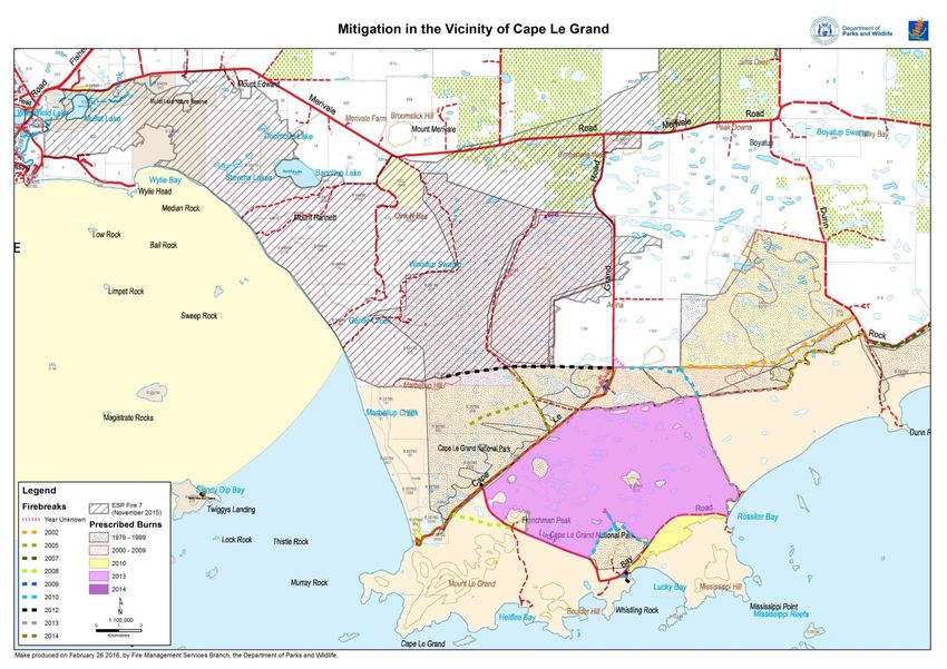
Department of Fire and Emergency Services
Major Incident Review of the Esperance district fires | 8 March 2016

This page is intentionally blank.

© Nous Group

nousgroup.com                                                          | i |
Department of Fire and Emergency Services
Major Incident Review of the Esperance district fires | 8 March 2016

Contents

Glossary of acronyms ................................................................................................................................... 4
1        Executive Summary............................................................................................................................ 5
2        The Esperance district fires occurred under catastrophic weather conditions and had a significant
         impact on the local community ......................................................................................................... 9
         2.1       Changes in land use combined with weather conditions had increased the risk of bushfire
                   in the Esperance district.......................................................................................................... 9
         2.2       Adverse weather conditions resulted in numerous fires across southern WA, including the
                   Cascades, Merivale and Cape Arid fires in the Esperance region ......................................... 12
         2.3       While response strategies were put in place, the catastrophic weather conditions of 17
                   November resulted in a significant escalation of these fires ................................................ 15
3        It was difficult to mobilise and maintain the initial response because the fires occurred in remote
         areas................................................................................................................................................. 24
         3.1       There are not enough government officers based in Esperance to staff an IMT for a
                   significant fire ........................................................................................................................ 24
         3.2       A remote region such as Esperance must draw in external resources, but these are difficult
                   to mobilise quickly ................................................................................................................ 29
         3.3       As a result, the IMT was under‐resourced during the major run of these fires, with
                   implications for its effectiveness .......................................................................................... 32
4        While regional support was strong, the ability of the SOC to support the response was
         compromised by system and process failures ................................................................................. 37
         4.1       Insufficient integration of key information processes made it hard to get a state‐wide
                   perspective on resources ...................................................................................................... 37
         4.2       Insufficient numbers of people in key management roles at all levels contributed to
                   challenges in understanding resource requirements ........................................................... 40
         4.3       In contrast, regional agencies worked well together to support the response .................... 41
5        Despite these resourcing challenges the response was generally well managed, although there
         are some clear areas for improvement ........................................................................................... 45
         5.1       These fires started on UCL, where multiple agencies are responsible for managing the fire
                   risk ......................................................................................................................................... 45
         5.2       Communications infrastructure was unreliable, which led to information gaps between the
                   fireground and IMT ............................................................................................................... 50
         5.3       Issues with systems and processes identified in previous reviews continue to frustrate the
                   response ................................................................................................................................ 52
6        Recommendations ........................................................................................................................... 55
         Recommendation 1: A unified and integrated fire sector across the whole fire hazard................. 55
                   Recommendation 1.1: Coordinated and targeted mitigation of fire risk ............................. 56

nousgroup.com                                                                                                                                               | ii |
Department of Fire and Emergency Services
Major Incident Review of the Esperance district fires | 8 March 2016
Recommendation 1.2: Co‐designed arrangements that support a unified response to fire 57
Recommendation 1.3: Review of institutional arrangements in the fire sector................... 58
Recommendation 2: Resourcing models appropriate to local needs, including fire risk and
remoteness ........................................................................................................................... 60
Recommendation 2.1: Structures to incorporate local knowledge and situational awareness
into the fire response .............................................................................................. 60
Recommendation 2.2: Flexible pre‐formed multi‐agency IMTs ........................................... 61
Recommendation 2.3: Appropriate and scalable resourcing models for remote locations . 62
Recommendation 3: Resolve reoccurring issues with systems and processes ............................... 63
Recommendation 3.1: IAP formats and processes appropriate to the nature of the
emergency response................................................................................................ 63
Recommendation 3.2: Cross‐agency resource management system ................................... 64
Recommendation 3.3: Live resource tracking system that can be used by all response
agencies ................................................................................................................... 65
Appendix A Criteria for declaration of emergency incident levels ........................................................... 66
Appendix B Proposed mobile based stations in Esperance ..................................................................... 67
Appendix C Agencies and organisations that have provided input into the MIR .................................... 68
Nous Group (Nous) has prepared the Major Incident Review of the Esperance District fires in good faith
for the Department of Fire and Emergency Services (DFES).
The information, opinions, statements, statistics and commentary contained in this report have been
prepared by Nous from material provided by DFES and other third parties. Nous may, at its absolute
discretion and without any obligation to do so, update, amend or supplement this document.
Nous does not express an opinion as to the accuracy or completeness of the information provided, the
assumptions made by the parties that provided the information or any conclusions reached by those
parties. Nous disclaims any and all liability (financial or otherwise) arising from actions taken in response
to this report. Nous disclaims any and all liability for any investment or strategic decisions made as a
consequence of information contained in this report. Nous, its employees, and any persons associated
with the preparation of the enclosed documents are in no way responsible for any errors or omissions in
the enclosed document resulting from any inaccuracy, mis‐description or incompleteness of information
provided or from assumptions made or opinions reached by the parties that provided information.
Furthermore, this publication should not be used by third parties without the express permission of DFES.
nousgroup.com | iii |Department of Fire and Emergency Services Major Incident Review of the Esperance district fires | 8 March 2016 Glossary of acronyms AFAC Australasian Fire and Emergency Service Authorities Council AIIMS Australasian Inter‐service Incident Management System BFB Bush Fire Brigade BGU Brigades, groups and units CASR Civil Aviation Safety Regulations COMCEN Communication Centre DEMC District Emergency Management Committee DFES Department of Fire and Emergency Services DoL Department of Lands FES Commissioner Fire and Emergency Services Commissioner HMA Hazard Management Agency IAP Incident Action Plan IBMC Inter‐agency Bushfire Management Committee IC Incident Controller IMT Incident Management Team ISG Incident Support Group MIR Major Incident Review MOC Metropolitan Operations Centre MoU Memorandum of Understanding Mt Million tonnes OASG Operational Area Support Group OBRM Office of Bushfire Risk Management P&W Department of Parks and Wildlife ROC Regional Operations Centre SEMC State Emergency Management Committee SES State Emergency Service SOC State Operations Centre UCL Unallocated Crown Land UMR Unmanaged Reserves USAR Urban Search and Rescue WA Western Australia WAFES Western Australia Fire & Emergency Services nousgroup.com | 4 |
Department of Fire and Emergency Services
Major Incident Review of the Esperance district fires | 8 March 2016
1 Executive Summary
The Department of Fire and Emergency Services (DFES) engaged the Nous Group (Nous) to conduct an
independent major incident review (MIR) of the Esperance district fires, including the Cascades, Merivale
and Cape Arid complex fires, which occurred in November 2015. The response to these incidents was
jointly managed by DFES, the Department of Parks and Wildlife (P&W) and Local Government. This
review is designed to identify key lessons in relation to how these agencies responded to and managed
these incidents, and provide recommendations to improve the response to similar incidents in the
future.
The Esperance district fires had a significant impact on the local community, including the tragic loss of
four lives1, as well as widespread agricultural losses, 16 property losses and damage to public
infrastructure. Those involved in developing this MIR extend our condolences to the local community, in
particular the family and friends of those who lost their lives in the fires.
A number of contextual factors contributed to the intensity of the Esperance district fires. Changes in
farming practices in the Esperance region have resulted in more widespread and higher yield cropping
areas, creating higher fuel loads across a larger area prior to harvest. Weather conditions over the
preceding winter and spring had contributed to high and combustible fuel loads, including higher crop
yields. Adverse weather conditions in November 2015 resulted in a high level of fire activity across the
southern part of Western Australia (WA). In the Esperance region, catastrophic weather conditions on
17 November resulted in a significant escalation of the Cascades, Merivale and Cape Arid fires, including
the major run of the Cascades fire. These conditions resulted in challenging fire behaviour, with the
Cascades fire in particular having unusually high intensities and rates of spread for a grassland fire. It is
thought to be the hottest grassland fire in WA’s recorded history, and possibly in Australia’s recorded
history.
Notwithstanding the significant impact of the fires, and in particular the tragic loss of life, the response
to the Esperance District fires was perceived to be broadly well managed, given the scale of the incident,
unpredictable fire behaviour and extreme conditions experienced during the fire. It is unlikely that the
Cascades fire could have been prevented from breaking out onto farmland, given the time and resources
available and the catastrophic weather conditions. The Cascades fire is universally believed to have been
unstoppable for the 4‐5 hours of its major run through farmland, until weather conditions improved.
Nevertheless, the experience of the Esperance district fires provides a valuable opportunity to improve
the management of future fire incidents. The MIR makes three overarching findings in relation to the
management of the Esperance district fires, these are:
It was difficult to mobilise and maintain the initial response because the fires occurred in
remote areas. Esperance is in a remote part of WA, with limited government agency resources
dedicated to fire management. This means that there are not enough government officers in
place to staff an Incident Management Team (IMT) for a significant fire. The pattern of fires and
predicted adverse weather conditions across the state meant that external resources were
initially not available, and when they were deployed the remoteness of the fires meant it took
time to get them in place. As a result, the IMT was under‐resourced during the escalation of
these fires, which impacted on its effectiveness. While this had a significant personal impact on
those responsible for managing the initial response, the lack of resources is unlikely to have
changed the overall outcomes of the fires.
1
Please note this MIR does not discuss the four fatalities. As at the date of this MIR, fatalities resulting from the Esperance district
bushfires are being investigated by the coronial inquest into the same incident.
nousgroup.com | 5 |Department of Fire and Emergency Services
Major Incident Review of the Esperance district fires | 8 March 2016
While regional support was strong, the ability of the State Operations Centre (SOC) to support
the response was compromised by system and process failures. The response to a major fire
incident requires support at the regional and state level, particularly in coordinating resource
requirements. However, some issues with sharing of information between agencies resulted in
the SOC being unable to maintain a strategic overview of state‐wide fire activity and resource
requirements. The challenge in understanding strategic resource requirements was exacerbated
by insufficient people in key management roles in the SOC and IMT. In contrast, regional
agencies worked well together to support the response through the Regional Operations Centre
(ROC), district emergency management arrangements and inter‐agency liaison groups.
Despite these resourcing challenges the response was generally well managed, although there
are some clear areas for improvement. The Cascades and Merivale fires started on Unallocated
Crown Land (UCL), for which responsibility for managing fire is diffused across multiple agencies.
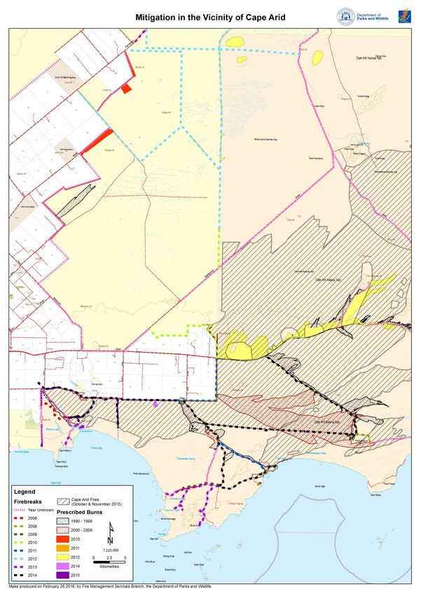
Mitigation on UCL outside of townsites is the responsibility of P&W, whereas response is the
responsibility of Local Government, creating discontinuity in managing fire. Communications
infrastructure was unreliable, which led to information gaps between the fireground and IMT.
There were also a number of reoccurring issues with systems and processes that have been
identified in previous reviews that continue to frustrate the response to fire.
The most significant findings of the MIR relate to managing resources in remote locations, in the context
of increasing risk posed by bushfires. This raises questions about how government agencies must work
together to most effectively use available resources to manage fire. The MIR makes three overarching
recommendations, each with three specific elements:
Figure 1: Summary of recommendations
Recommendation 1: A unified Recommendation 2: Resourcing Recommendation 3: Resolve
and integrated fire sector across models appropriate to local needs, reoccurring issues with systems
the whole fire hazard including fire risk and remoteness and processes
1.1 Coordinated and targeted 2.1 Structures to incorporate local 3.1 IAP formats and processes
mitigation of fire risk knowledge and situational appropriate to the nature of the
1.2 Co‐designed arrangements awareness into the fire response emergency response
that support a unified response 2.2 Flexible pre‐formed multi‐ 3.2 Cross agency resource
to fire agency IMTs management system
1.3 Review of institutional 2.3 Appropriate and scalable 3.3 Live resource tracking system
arrangements in the fire sector resourcing models for remote that can be used by all response
locations agencies
These recommendations reflect opportunities for improvement that are known across the fire response
agencies, and have been highlighted in previous major incident reviews in WA. In most of these areas,
attempts have already been made to address the issues, both by individual agencies and through the
Inter‐agency Bushfire Management Committee (IBMC). However, the experience of the Esperance
District fires indicates that there is still further work to be done. The fire response agencies, in particular
DFES, P&W and Local Government, must take a collaborative and active approach to addressing
opportunities for improvement. Successful implementation of the recommendations will require
dedicated resources from all of the agencies with responsibilities for managing fire. Ultimately, this will
improve the ability of the WA fire sector to manage future major fire incidents.
nousgroup.com | 6 |Department of Fire and Emergency Services
Major Incident Review of the Esperance district fires | 8 March 2016
Methodological approach to the MIR of the Esperance District fires
The MIR is intended to provide a factual assessment of the management of the WA fire sector’s
management of the incident, and from this to identify practical recommendations that can strengthen
the WA fire sector’s capacity to manage future major fire incidents. The objective of this MIR as stated
by DFES is to understand the aspects of the event that worked well and should be built on and highlight
any issues that can be improved upon. In particular, the MIR will address the following:
understand and document the context of the incident
the effectiveness of the Incident Management Team’s decision making and timeliness to
coordinate and manager operational activities
the effectiveness of Command, Control, Coordination and Communication at Incident,
Regional, State and Agency Level
the compliance of responding agencies with relevant legislation, policies, endorsed actions
and measures, agency plans and associated procedures and guides
the effectiveness of operational horizontal and vertical communications from the incident
ground through and across all operational levels
the effectiveness and timeliness of communicating situational awareness across agencies.
The MIR used a combination of desktop review and stakeholder consultation (including single and group
interviews, focus groups and workshops) to inform the findings and recommendations of the MIR of the
Esperance District fires. The use of multiple data sources enabled a comprehensive understanding of the
management of the fires from which to develop robust findings and recommendations. The MIR
reviewed documents and materials that could usefully inform the MIR of the Esperance District fires.
This included the following documents:
Relevant state policies and legislation, including the Bush Fires Act, the State Emergency
Management Plan Westplan – Fire, State Emergency Management Policies, and IBMC2
endorsed actions and measures.
Departmental specific policies and procedures, including the DFES Western Australian Fire &
Emergency Services (WAFES) Manual and Operational Directives and P&W policies
Incident documentation, such as Incident Action Plans (IAPs) and associated documents,
Regional Situation Reports, meeting minutes
Records and attachments from the WebEOC Information Logs and Request Logs3
Written submissions received from agency personnel and volunteers associated with the
response
Information relating to the bush fire risk conditions, such as mitigation measures, information
on land use practices, and weather conditions.
2
The IBMC includes representation from DFES, P&W, the OBRM, WALGA and WA Police.
3
WebEOC is a web‐enabled system used for incident management by DFES, WA Police and the Department of Health. In 2008, SEMC
endorsed the use of WebEOC as the preferred crisis information management system for emergency management agencies in WA.
Currently, DFES uses the Information Log, the Request Log, the State Preparedness Board and the Incident Action Plan. WebEOC is used
to facilitate vertical communication of situational awareness, operational information and resource requirements between the IMT,
ROC/MOC and SOC.
nousgroup.com | 7 |Department of Fire and Emergency Services
Major Incident Review of the Esperance district fires | 8 March 2016
The desktop review was partially completed prior to the stakeholder consultation to provide a baseline
understanding of the context of the incidents and to guide stakeholder consultation. Areas of interest
revealed through stakeholder consultation were then investigated through further desktop review.
Stakeholders to be consulted for the MIR were identified through DFES, P&W and Local Government
representatives. Face to face consultations with stakeholders were held in Albany, Esperance and Perth,
with telephone consultations held as required. The groups of stakeholders consulted included:
State Operations Centre (SOC)4: A focus group was held with DFES personnel involved in the
SOC and further interviews were held with DFES and P&W personnel involved in the SOC and
related state level DFES functions.
Regional Operations Centre (ROC)5: A mixture of focus groups and interviews were held with
DFES and P&W personnel involved in the Great Southern and Lower South West ROCs.
Incident Management Team (IMT) 6: A mixture of focus groups and interviews were held with
DFES, P&W and Local Government personnel involved in the IMT.
Firefighting response: A mixture of focus groups and interviews were held with people
involved in the firefighting response, including volunteers and volunteer association
representatives. Written feedback from volunteers was also provided through volunteer
associations and through DFES District Officers.
Inter‐agency coordination groups and support agencies: A mixture of focus groups and
interviews were held with members of the combined Incident Support Group (ISG) and
Operational Area Support Group (OASG), and with support agencies identified through the All
Hazards Liaison Group.
Local government: A focus group was held with Local Government representatives.
Office of Bushfire Risk Management (OBRM): An interview was held with the OBRM.
In addition to stakeholder consultation, briefings were provided to the DFES Deputy Commissioners and
to a cross‐agency reference group (consisting of DFES, P&W, Local Government and State Emergency
Management Committee (SEMC) representatives) at key points in the MIR to test the emerging themes
and key findings.
A complete list of the agencies and organisations that provided input to the MIR is contained in
Appendix C.
4
The SOC maintains overall command, control and coordination of resources, maintains an overview of available resources and
maintains a strategic overview of the resourcing requirements and incident activity across the state. (DFES, WAFES Manual Part Three:
State Operations Centre)
5
The ROC coordinates operational resources at a regional level (DFES, WAFES Manual Part Five: Regional Operations Centre). The
Esperance District fires were coordinated through the Great Southern ROC in Albany.
6
An IMT is a group of incident management personnel led by the incident controller, who are responsible for the overall management of
an incident. (SEMC, Incident Management: State Emergency Management Policy No.4.1, 2013)
nousgroup.com | 8 |Department of Fire and Emergency Services
Major Incident Review of the Esperance district fires | 8 March 2016
2 The Esperance district fires occurred under
catastrophic weather conditions and had a
significant impact on the local community
The Esperance district fires in November 2015 consisted of two fires and a fire complex: the Cascades
fire (128,000 hectares), the Merivale fire (18,000 hectares), and the Cape Arid complex (164,000
hectares).7 The fires had a significant impact on life, property, the environment and the community.
There were four fatalities, as well as widespread agricultural losses, 16 property losses and damage to
public infrastructure. In the Cape Arid complex, significant areas of the Western Ground Parrot habitat
were burnt.
A number of contextual factors contributed to the intensity of the Esperance district fires. Changes in
farming practices in the Esperance region have resulted in more widespread and higher yield cropping
areas, resulting in higher fuel loads across a larger area prior to harvest. Longer term climatic changes in
Esperance have likely increased the risk of bushfire. In the shorter term, weather conditions over the
preceding winter and spring had contributed to high and combustible fuel loads, including higher crop
yields.
Adverse weather conditions in November 2015 resulted in a high level of fire activity across the southern
part of WA, with over 40 fires recorded by DFES regions on 15 November. There were three fires of
concern in the Esperance area: Cascades, Merivale and the Cape Arid complex. Containment efforts
were undertaken by local brigades with support from DFES and P&W personnel, however catastrophic
weather conditions on 17 November resulted in a significant escalation of these fires, including the
major run of the Cascades fire. These conditions resulted in challenging fire behaviour, with the
Cascades fire in particular having an unusually high intensity and rate of spread for a grassland fire. It is
thought to be the hottest grassland fire in WA’s recorded history, and possibly in Australia’s recorded
history.
This section describes the contextual factors that increased the risk of bushfire in Esperance and the
chronology of the Esperance District fires from the time of ignition on 15 November to the point of
transition of control on 26 November for all fires back to Local Government (for the Cascades and
Merivale fires) and P&W (for the Cape Arid fires).
2.1 Changes in land use combined with weather conditions had
increased the risk of bushfire in the Esperance district
There are three contextual factors that increased the risk of bushfire in the Esperance district prior to
November 2015:
changes in farming practices
longer term climatic changes
seasonal weather patterns.
7
Size of fires when the Esperance District incident was downgraded to Level 1 on 25 November. By this time, the Cascades and Merivale
fires were contained and controlled, but the Cape Arid complex was still uncontained and uncontrolled.
nousgroup.com | 9 |Department of Fire and Emergency Services
Major Incident Review of the Esperance district fires | 8 March 2016
Each of these contextual factors is discussed in the following section.
Changes in farming practices in the Esperance region have contributed to the increased risk of
bushfire
The economy of the coastal part of the Goldfields‐Esperance region is based on agriculture, fisheries,
mining (in Ravensthorpe) and tourism.8 Agriculture is therefore the predominant land use by area.
Between 1990 and 2000 the Esperance region experienced an increase of 50% in the total cropped area
and a move away from livestock farming. For example, the number of sheep in the Esperance region has
decreased over the past two decades by 45‐65%.9 Previously, paddocks with livestock acted as natural
fire breaks due to lower fuel loads, whereas cropped areas are more combustible prior to harvest. Post‐
harvest, stubble is retained to reduce soil erosion which maintains a combustible ground cover and
increases fuel load in pre‐harvest fields.
Crop yields in the Esperance region have increased, reflecting improvements in farming practices such as
a significant increase (75‐100%) in water use efficiency (amount of grain produced per mm of total water
used), which is amongst the highest in Australia.10 Collectively, these changes in land use mean greater
fuel loads across a larger area. This increases the risk posed by bushfire.
The 2015 harvest was shaping up to be an above average year for crop farmers in the Esperance district.
Local people reported yields of up to 5 tonnes per hectare, which was estimated to be around 40‐50%
harvested at the time of the fires. The Esperance port zone had received approximately 2.35 million
tonnes (Mt) of grain as of January 2016 for the 2015 harvest, despite the losses from the fire and wind in
November. In comparison, the average for the five previous harvests was 1.8 Mt.11 These changes were
consistently cited by local people as contributing to increased risk of bushfire.
The Esperance region has experienced a shift towards consolidation of farms, with fewer farmers
managing larger areas. This reflects a national trend, with a decrease in the number of grain farms from
40,000 to 27,000 between 1980 and 2010.12 Whilst this might reduce risk to life and property, it also
means fewer local fire responders and potentially less mitigation work being done on private farmland.
Longer term climatic changes in Esperance have likely increased the risk of bushfire
A hotter climate in the south west of WA has resulted in more severe, hot days and drier conditions.13
This has been linked to an increase in lightning strikes, some of which ignite fires, as well as greater
likelihood of adverse weather conditions that contribute to escalating intensity of fires.14
Consistent with the trends observed throughout Australia, temperatures in the Esperance region have
risen by approximately 1 degree over the past one hundred years. However, evidence of long term
changes in rainfall is mixed, with a reduction of up to 10mm per decade since 1910, but an increase at a
similar rate since 1970. 15
8
Department of Regional Development, Goldfields‐Esperance: a region in profile, 2014
9
R Kingwell and D Pannell, Economists’ thoughts on WA broadacre farming toward 2020, Institute of Agriculture Forum, 2009
10
Australian Export Grains Innovation Centre, Wheat water use (production) efficiency, 2016
11
Data from CBH Group, provided by Department of Agriculture and Food WA
12
Grains Research and Development Corporation, Grains Industry National Research, Development and Extension Strategy, 2011, p. 13
13
Climate Council, Be Prepared: Climate Change and the Australian Bushfire Threat, 2013, p. 26
14
Climate Council, Be Prepared: Climate Change and the Australian Bushfire Threat, 2013, p. 24
15
Bureau of Meteorology, Meteorological Aspects of the Esperance District Fires, November 2015, 2016, p. 2, and additional information
provided by Bureau of Meteorology
nousgroup.com | 10 |Department of Fire and Emergency Services
Major Incident Review of the Esperance district fires | 8 March 2016
Seasonal weather patterns in Esperance also increased the risk of bushfire for the 2015‐16
Seasonal weather patterns in the Esperance region in 2015 combined above average winter rainfall,
creating optimum conditions for vegetation growth, followed by an unusually dry and warm spring. For
example, Salmon Gums Research Station, around 100km north of Esperance town, reported its highest
winter rainfall in 88 years; and a number of sites in the Esperance region experienced their warmest
spring on record.16
The winter weather patterns resulted in greater vegetation growth with high potential fuel loads in and
around the Esperance region. Subsequently, the spring weather resulted in the vegetation growth
becoming very dry. The fuel curing, which is the measure of dead material in a grassland environment,
was recorded at 100% in the Esperance Shire Coast and Esperance Shire Inland Fire Districts in the lead
up to and during the fires,17,18 indicating that the vegetation was dry and combustible. Combined with
the above average anticipated harvests of 2015 (with crop yields reported to up to 5 tonnes per
hectare), this created high and combustible fuel loads. High fuel loads were also observed on road
verges.
The high fuel loads were compounded by significantly drier soil conditions than the last five seasons, as
measured by the Keetch‐Byram Drought Index and the Soil Dryness Index. This meant that a
combination of significantly drier soil conditions and a high percentage of dead vegetation increased the
risk of bushfires in the Esperance region and across the state. This heightened risk of bushfire was
forecast in November 2015.
16
Bureau of Meteorology, Meteorological Aspects of the Esperance District Fires, November 2015, 2016, pp. 2‐8
17
Bureau of Meteorology, Meteorological Aspects of the Esperance District Fires, November 2015, 2016, p. 11
18
A curing value of 0% represents totally green vegetation and 100% represents totally dry vegetation.
nousgroup.com | 11 |Department of Fire and Emergency Services
Major Incident Review of the Esperance district fires | 8 March 2016
Figure 2: Bushfire potential for the 2015‐16 fire season as at November 201519
2.2 Adverse weather conditions resulted in numerous fires
across southern WA, including the Cascades, Merivale and
Cape Arid fires in the Esperance region
The movement of a weather system across the state over 14‐15 November resulted in a high level of fire
activity, including numerous fires in the Great Southern region and the Esperance district. By the evening
of 15 November, there were two fires in the Esperance district that continued to be of concern: the
Cascades and Merivale fires. The pattern of fires across the state, in the Great Southern region and in
the Esperance district over 14‐15 November is discussed in the following section.
There was a high level of fire activity across the southern part of WA over 14‐15 November
Over the weekend of 14‐15 November 2015, the movement of a trough system in an easterly direction
over the southern part of WA brought a band of thunderstorms that ignited fires across a large area. This
resulted in a high level of fire activity across the southern part of WA, with over 40 fires recorded by
DFES regions on 15 November (see Figure 3).20
19
Bushfire and Natural Hazards Cooperative Research Centre, Hazard Note 12, November 2015. An above normal bushfire potential
indicates that resources within the region will be insufficient to fight a bushfire, and additional resources from other areas will be
required.
20
DFES, Situation Reports Per Region, 15 November 2015
nousgroup.com | 12 |Department of Fire and Emeergency Services
Major Incident Review of the Esperance district fires | 8 Marcch 2016
Figuree 3: Active bushfires and pprescribed bu W on 15 Noveember21
urns across WA
Stakehoolders from DFES
D and P&WW reported thhat this was an a unusually high level of fire activity at
a this
early stage of the firre season. In addition to bbushfires ignitted across the state, theree were also over
o 40
22
bed burns in process. Ma
prescrib any of these prescribed burns had bee en running ovver the prior week,
w
leading to fatigued crews
c comingg into the higgh fire activityy of 14‐15 No
ovember. Connsequently, th here was
an exceeptional demaand on fire aggencies, incluuding volunte eer brigades, and competiition for resources
across tthe state. Witth the majoriity of fires occcurring in thee more denseely populatedd parts of the e state, in
particullar the Perth metropolitan n area and Soouth West reggion, demand d for firefightting resources was
highest in these regiions. Fire activity continueed to be high across the sttate throughoout the perio od of the
Esperannce District fires, includingg the Mt Soluus fire, which was ignited ono 15 Novem mber, and a fire north
of Yanchep that wass ignited on 22 2 November .
Fire acttivity was alsso high across the Greatt Southern re
egion
On 15 NNovember there were 29 incidents rec orded by DFEES across the Great South ern region. These
T
included:
10 fires in managed by local individu
n the Shire off Esperance (m uals and brigaades);
four fires in the Shire of
o Plantageneet (managed by local briga
ades);
four fires in the Shire of
o Boddingtoon (managed by local briga
ades);
one fire in
n a remote arrea near Mt H
Holland in the
e Shire of Kondinin (manaaged by DFES);
21
Maps p
provided by DFES Spatial Services team and P&W FFire Managementt Services Branch, based on data ffrom DFES and P&
&W records
22
Reporteed in consultation with P&W perssonnel
nousgroup.com | 13 |Department of Fire and Emergency Services
Major Incident Review of the Esperance district fires | 8 March 2016
nine fires in Albany (seven of which managed by local brigades and two managed by P&W);23
one fire in Mt Solus (managed by P&W).24
By the end of the day on 15 November, most of the fires in the Great Southern region had been largely
contained and were being mopped up. A small number of fires remained uncontained, including the fire
in the remote area near Mt Holland, two fires in Albany, two fires in Esperance25 and the fire in Mt Solus,
which was being managed by P&W.26 These remaining fires were dispersed across the Great Southern
region, with the fires in Albany of particular concern due to their proximity to communities.
Two of the fires in the Esperance district were still of concern by the evening of 15 November
2015
By the evening of 15 November, eight of the fires ignited by lightning in the Esperance district had been
contained by local brigades. There were two fires that continued to be of concern: the Cascades and
Merivale fires.
Figure 4: Uncontained bushfires in the Great Southern region on 16 November27
Geraldton
0 40 80 120
Kilometres
MIDWEST
GASCOYNE
Karroun Hill Mount Manning
Nature Reserve Range Nature
Reserve Queen Victoria
Helena and Spring Nature
Aurora Ranges Reserve
Conservation
Park
GOLDFIELDS
MIDLANDS
Gingin
Northam Cunderdin
Mundaring
Jilbadji
Nature
Reserve
Brookton Dundas Nature
Reserve
Pingelly
Pinjarra
GREAT
SOUTHERN Lake Grace
SOUTH
Bunbury WEST
Collie CapeArid
National Park
Ravensthorpe
Busselton Nuytsland
Nature Reserve
Esperance
LOWER Bridgetown Fitzgerald River Hopetoun
National Park
SOUTH
WEST
Manijimup
Pemberton
Northcli e Mount Barker
Mount Roe
National Park
Albany
The Cascades fire, which had started on UCL in the Lake Mends area, was still active on the evening of 15
November, with weather conditions for 16 November predicted to be favourable to ongoing
containment efforts. The risk posed by the Cascades fire was identified as significant, however P&W
23
DFES, Great Southern Regional Situation Report, 15 November 2015
24
DFES, Southwest Regional Situation Report, 15 November 2015
25
DFES, Great Southern Regional Situation Report, 15 November 2015
26
DFES, Southwest Regional Situation Report, 15 November 2015
27
Maps provided by DFES Spatial Services team, based on data from DFES and P&W records
nousgroup.com | 14 |Department of Fire and Emergency Services
Major Incident Review of the Esperance district fires | 8 March 2016
considered that the Perth Hills Complex, which consisted of six fires in the Mt Solus area, posed a greater
risk overall.28
The Merivale fire, near Lake Doombup, was also still active on the evening of 15 November. Protection
of private properties within the Stockyard Creek area was deemed to be the priority.
Both the Cascades and Merivale fires were categorised as a Level 1 incident29 at this stage and under the
control of Local Government. DFES and P&W provided support from the P&W office, including support
with developing containment strategies and aerial intelligence.
There was no report yet of fires in the area of the Cape Arid National Park.
2.3 While response strategies were put in place, the
catastrophic weather conditions of 17 November resulted in
a significant escalation of these fires
Over 16 November, local brigades undertook initial response strategies for the Cascades and Merivale
fires, with the support of local DFES and P&W personnel. By the end of the day, the Cascades and
Merivale fires had not yet been contained. However, local agency personnel and volunteers were
confident that the strategies would be successful in containing the fires, taking into account the
predicted adverse weather conditions for the following day.
However, catastrophic weather conditions on 17 November resulted in a significant escalation of the
fires, including the major run of the Cascades fire. Under these adverse weather conditions, fire
suppression strategies were not possible. The Cascades and Merivale fires were transitioned to DFES
control under a Section 13 declaration (at 12.30pm) and the upgrading of the incident to Level 3 (at
7.20pm). At the same time, P&W were responding to fires in Cape Arid National Park, which were then
brought under the management of a single multi‐agency IMT on 19 November. The Esperance District
fires remained active and were managed by the multi‐agency IMT until transitioning back to local
government and P&W control on 26 November.
This section describes the chronology of the Cascades, Merivale and Cape Arid complex fires from 16
November to the point of transition of control on 26 November for all fires back to Local Government
(for the Cascades and Merivale fires) and P&W (for the Cape Arid fires).
Initial response strategies were put in place for the Cascades and Merivale fires on 16 November
Over the course of 16 November, the response to the Cascade and Merivale fires remained under the
control of Local Government, and local brigades continued to undertake containment efforts with the
support of an IMT consisting of four DFES and P&W personnel based in Esperance. Both fires were
considered to pose a risk, as they were both in difficult to access terrain. It was thought that the
Merivale fires constituted the highest risk due to a greater potential to impact life and property on the
east and west sides of the fire. Consequently, a member of the local brigade visited seven properties
which were identified as being at risk in the Merivale area, and the residents of all properties bar one
agreed to leave.
28
DFES, DFES PaW Liaison Officer Situation Report 2, 17 November 2015
29
A Level 1 incident is characterised by being able to be responded to and managed by local resources, having a low level of complexity
and having a relatively minor impact on the community. See Appendix A for a full description of incident levels.
nousgroup.com | 15 |Department of Fire and Emergency Services
Major Incident Review of the Esperance district fires | 8 March 2016
The Cascades fire was burning in a complex lake system, close to Lake Mends. Local brigades, supported
by DFES and P&W, applied three containment strategies30 to the Cascades fire:
1. secure the fire edge with mineral earth breaks using two private machines
2. re‐treat existing fuel modifications on the UCL / private property interface
3. landowners on the private property interface to harvest crop and construct mineral earth breaks
For the Merivale fire, the strategy was to strengthen existing containment lines using a strategic
boundary to the east of the fire.
Fires were reported in the Cape Arid region on the afternoon of 16 November. These fires quickly
escalated through long unburnt fuels (age predates record‐keeping in area) in a north‐east direction.
P&W crews were deployed to investigate the situation.
The incident response on 16 November was predominantly undertaken by local volunteer brigades and
various private appliances, including machinery sourced from farmers. P&W also supported the
fireground response with around six personnel and one appliance, initially at the Merivale fire but later
in the afternoon redeployed to investigate the Cape Arid fires.
Local agency personnel and volunteers had been confident that the strategies would be successful in
containing the fires, taking into account predicted adverse weather conditions for the following day. By
the afternoon of 16 November, however, the Cascades and Merivale fires had not yet been contained.
The remoteness of the Cascades fire meant that it took time for machinery to arrive at the fireground. A
machine also got caught in the boggy terrain of the lakes system. The terrain of the Merivale fire also
presented challenges, with razorback sand dunes systems making it difficult for crews to consolidate a
strategic boundary. As a result of the delays in completing the containment strategies, DFES issued
bushfire alerts for both fires. A Bushfire Advice31 alert was issued for the Stockyard Creek and Mullet
Lake areas in Merivale at 4.05pm; and a Bushfire Advice alert was issued for North Cascade at 4.15pm.
Alongside the local response to fires on 16 November, preparations were being undertaken at the
regional level by the ROC. Adverse weather conditions were predicted for the following day, with a
catastrophic fire danger forecast32 initially for the Roe sub‐district, and later shifting to the Esperance
Shire Inland district.33 A total fire ban for the entire Great Southern Region was declared, to be
implemented from midnight, and communicated to all Shires in the region. The Great Southern Region
also assembled a Level 234 IMT in Narrogin on 16 November.
30
Documented in partial IAPs completed by DFES on 15 November.
31
A Bushfire Advice alert indicates that “a fire has started but there is no immediate danger” (DFES website – warning systems)
32
‘Catastrophic’ fire conditions are considered the worst conditions for a bush or grass fire. A fire that starts in ‘catastrophic’ fire
conditions is extremely hard to control and takes significant firefighting resources and cooler conditions to manage.
33
The routine Emergency Services Weather Briefing issued on 16 November at 10.50am forecast catastrophic fire danger for the Roe
sub‐district, and isolated catastrophic conditions possible throughout the Great Southern and Central Wheat Belt districts for 17
November. An additional non‐routine Emergency Services Weather Briefing was issued later that day at 5.05pm, forecasting
catastrophic fire danger for the Esperance Shire Inland district. This is consistent with the Fire Weather Warning issued by the Bureau of
Meteorology at 3.05pm on 16 November, which forecast catastrophic fire danger for Esperance Shire Inland.
34
A Level 2 incident is characterised by requiring a multi‐agency response, and being more complex in terms of size, resources, risk
and/or community impact than a Level 1 incident. See Appendix A for a full description of incident levels.
nousgroup.com | 16 |Department of Fire and Emergency Services
Major Incident Review of the Esperance district fires | 8 March 2016
Catastrophic weather conditions on 17 November resulted in a significant escalation of the fires,
including the major run of the Cascades fire
Figure 5: Esperance district bushfires on 17 November35
Dundas
Nature
Reserve
0 10 20 30 40
Peak Charles Kilometres
Coo
National Park Dowak
lga
rde
-Es
Salmon Gums
per
anc
GREAT SOUTHERN
eH
wy
Red Lake
GrassPatch
Cape Arid
National Park
Beaumont
Nature
Cheadanup
Cascade Kau Rock Reserve
Nature Scaddan Nature
Reserve
Reserve
Nuytsland
Gibson Nature
Reserve
Coomalbidgup
Dalyup
Munglinup Condingup
Shark Lake
Sout h Coast Hwy Esperance
Merivale
Cape Le Grand
Wharton
National
Cascades Park
Merivale
Cape Arid Complex
UCL Unmanaged / unallocated crown land National Parks/Nature Reserves
Cascades fire shape is as of 17 November 5.07pm; Merivale and Cape Arid fire shapes not available for 17 November.
As anticipated, the Esperance region experienced catastrophic weather conditions on the afternoon of
17 November. This resulted in a significant escalation of the fires, including the major run of the
Cascades fire. Under these adverse weather conditions, fire suppression strategies were not possible. In
response to the expected weather conditions, Local Government implemented harvest and vehicle
movement bans for the west zone of the Shire of Esperance at 8.00am, extending to the whole Shire by
11.30am. Local farmers were notified of the bans by SMS. This restricted vehicles from moving through
crop and reduced the risk that the operation of machinery would spark further fires.
The management of the Cascades and Merivale fires transitioned to DFES after a Section 13 declaration
was made at 12.30pm, which appointed a DFES officer as Incident Controller (IC). The Cape Arid fires
remained under the control of P&W, with personnel working on plans for managing the fire, but with no
suppression activity taking place given the weather conditions.36
Catastrophic weather conditions
Catastrophic weather conditions were anticipated for 17 November in the Esperance district, with high
temperatures, high wind speeds and low humidity.
A spot fire weather forecast was issued for Lake Mends (in the vicinity of the Cascades fire) early on 17
November, forecasting conditions to peak at 3pm with temperatures of 42 degrees, relative humidity of
6% and winds of 40km/h gusting to 60km/h.37 In the event, however, winds were measured to be
35
Maps provided by Department of Fire and Emergency Services Spatial Services team, based on data from DFES and P&W records
36
DFES, Great Southern Regional Situation Report, 17 November 1600hr
37
Bureau of Meteorology, Spot Fire Weather Forecast for Lake Mends, issued at 05:26am Tuesday 17 November 2015
nousgroup.com | 17 |Department of Fire and Emergency Services
Major Incident Review of the Esperance district fires | 8 March 2016
consistently 50‐60 km/h during the afternoon, with wind gusts up to 70‐80 km/h.38 As predicted,
temperatures reached above 40 degrees by the afternoon.
Challenging weather conditions were also experienced for the Merivale fire over 17 November. By
1.00pm, the temperature in the Merivale area was 38 degrees, relative humidity was between 15% and
20%, and winds were from the north‐west of around 30 km/h gusting to 40 km/h. The NW winds
increased through the afternoon to around 45 km/h.
In the Shire of Esperance, the following weather conditions were observed at various points during the
day (see Figure 6).
Figure 6: Weather conditions in Esperance on 17 November39
Grassland Forest fire
Temperature Wind speed Gust speed
Location Time fire danger danger
(degrees) (km/h) (km/h)
index index
Esperance town 3.30pm 40.7 46 70 180 116
Cascades 12.50pm 41.3 42 53 181 143
Scaddan 1.00pm 41.2 34 52 175 140
Based on the observed weather conditions on 17 November, the fire danger rating was considered to be
well beyond the threshold for classification as ‘catastrophic’. The threshold for a catastrophic
classification is a fire danger index of 100 or higher, however the McArthur Grassland Fire Danger Index
for the fires peaked at 222 at around 3pm. This indicates that the conditions were among the most
severe ever experienced in southern Australia.40
Cascades fire behaviour
Cascades fire: sequence of events on 17 November
Prior to ~11.00am: Fire burns SE in UCL under relatively benign weather conditions
~11.00am: Fire moves rapidly SE under strong NW winds
11.30am: Bushfire Advice alert re‐issued
~11.45am: Fire crosses from UCL to private property on Ned’s Corner Road
12.30pm: Management of the fire transferred to DFES under Section 13
1.10pm: Bushfire alert upgraded to Watch and Act
3.30pm: Cascades fire upgraded to Level 2 incident
~3.50pm: Fire crosses Griggs Road, leading to four fatalities
~5.00pm: Fire crosses the Coolgardie Esperance Highway at Scaddan
5.50pm: Bushfire alert upgraded to Emergency Warning
~5.00pm‐7.00pm: Wind shifts to SW alongside easing weather conditions
7.20pm: Incident declared Level 3
38
N Burrows, Fuels, Weather and Behaviour of the Cascade Fire (Esperance Fire #6) 15‐17 November 2015, 2015, p. 8
39
DFES, Bush Fire Investigation Report ‐ Cascades, 2015, p. 0
40
N Burrows, Fuels, Weather and Behaviour of the Cascade Fire (Esperance Fire #6) 15‐17 November 2015, 2015, p. 9
nousgroup.com | 18 |Department of Fire and Emergency Services Major Incident Review of the Esperance district fires | 8 March 2016 Over the morning of 17 November, the Cascades fire continued burning in the bushland on UCL resulting in an estimated 5km long fire front. There were strong winds from the north‐west by around 11am, resulting in multiple flare ups of the fire as it moved in a south‐east direction towards private property. Crews reported seeing the fire jump across a lake that would represent a distance of 200m‐400m. A Bushfire Advice alert for North Cascade was re‐issued by DFES at 11.30am. Under the extreme fire conditions, at around 11.45am the Cascades fire jumped across fuel modification breaks on the interface of UCL and private property, which consisted of substantial pre‐existing scrub rolling and other fuel treatment. The fire moved rapidly once it had entered private property, further encouraged by the relative dryness of the fuel in the area, as well as the high fuel loads on farmland. The bushfire alert for North Cascade was upgraded to a Watch and Act alert41 at 1.10pm. The Cascades fire was upgraded to a Level 2 incident at 3.30pm. During its major run over the afternoon of 17 November, the Cascades fire is estimated to have moved at a rapid rate of spread of up to at 15 km/h, and estimated to have travelled approximately 70 km over a five hour period, crossing the Coolgardie Esperance Highway at around 5.00pm.42 An Emergency Warning43 was issued at 5.50pm for North Cascade, and the fire was upgraded to a Level 344 incident at 7.20pm. By late afternoon the wind shifted from north‐west to south‐west, and by 8.00pm had eased to around 20 to 30km/h. The wind shift resulted in multiple fingers emerging on the northern flank of the fire, but the easing weather conditions prevented this from becoming a wide head fire. By the end of 17 November, the Cascades fire had burned an area of around 118,000 hectares. Over the afternoon of its major run south‐east on 17 November, the Cascades fire is estimated to have reached an intensity of around 45,000 kW/m.45 It is thought to be the hottest grassland fire in WA’s recorded history, and possibly in Australia’s recorded history.46 This intensity of fire behaviour far exceeds the threshold for effective suppression, with direct attack unlikely to succeed for grassland fires above 5,000 kW/m and indirect attack likely to fail for grassland fires above 8,000 kW/m.47 Given that direct and indirect attack strategies were no longer possible, the response strategies were focused on protection of life, such as warning properties of the danger. During the afternoon period of the major run of the Cascades fire, four fatalities occurred on Griggs Road in Scaddan.48 There were multiple residential, commercial and storage property losses, damage to infrastructure, and agricultural losses to infrastructure, crops and stock. The fire also impacted on the Coolgardie Esperance Highway. Sections of the Coolgardie Esperance Highway, West Kalgoorlie Esperance rail line, Mount Burdette and Salmon Gums Repeaters, Worley Parsons Gas Pipeline and three public schools were deemed to be at risk and roads were closed. Two assisted evacuations were 41 A Bushfire Watch and Act alert indicates that “A fire is approaching and conditions are changing, you need to leave or prepare to actively defend to protect you and your family” (DFES website – warning systems) 42 DFES, Bush Fire Investigation Report ‐ Cascades, 2015 43 A Bushfire Emergency Warning indicates that “you are in danger and you need to take immediate action to survive as you will be impacted by fire” (DFES website – warning systems) 44 A Level 3 incident is characterised by being protracted, large and resource intensive. They typically require significant coordination of multi‐agency resources, and have a high level of complexity and community impact. See Appendix A for a full description of incident levels. 45 DFES, Bush Fire Investigation Report ‐ Cascades, 2015, p. 9. Based on assumptions of 6 t/ha and 15.3 km/h rate of spread in natural grass, which equates to 45,900 kW/m. 46 Discussed in stakeholder consultations with P&W personnel. While this is extreme fire intensity for a grassland fire, it is less extreme than major forest fires. Severe forest fires can burn at intensities of over 100,000 kW/m. 47 Based on Muller, Report on a Bush Fire Threat Analysis for Western Australia, 2008, as presented in the Guide and Tables for Bushfire Management in Western Australia, 2011. 48 Please note this MIR does not discuss the four fatalities. As at the date of this MIR, fatalities resulting from the Esperance district bushfires are being investigated by the coronial inquest into the same incident. nousgroup.com | 19 |
Department of Fire and Emergency Services
Major Incident Review of the Esperance district fires | 8 March 2016

undertaken from Salmon Gums and Grass Patch: one on the evening of 17 November north to
Norseman, and a second later that night south to Esperance.

Merivale fire behaviour
Under strong north‐west winds, high temperatures and low humidity, the Merivale fire moved rapidly in
a south‐east direction. A Bushfire Advice alert for the Merivale Fire was re‐issued at 11.25am and
upgraded to a Watch and Act at 11.55am. At 3.30pm, the Merivale fire was upgraded to a Level 2
incident. The forecast wind change from the north‐west to the south‐west was expected to put
residential properties at risk. Once the wind had shifted at around 6.00pm, the fire moved rapidly in a
north‐east direction. An Emergency Warning was issued at 9.04pm, after the fire had crossed Cape Le
Grand Road. The fire burned through Stockyard Creek, resulting in two residential property losses. P&W
relocated campers from Cape le Grand National Park. By the end of 17 November, the Merivale fire had
burned through 15,000 hectares.

The Esperance District fires remained active and were managed by a single multi‐agency IMT until
transitioning back to local government and P&W control on 26 November

             Figure 7: Esperance district bushfires on 18 November, following the catastrophic conditions on 17
                                                         November49
                                                                                                                                            Dundas
                                                                                                                                            Nature
                                                                                                                                            Reserve

                                                                                                                                                                       0   10   20    30    40
                                                                                                                                                                                                 Kilometres
                                                          Coo

                            Peak Charles
                            National Park                            Dowak
                                                             lga
                                                                rde
                                                                   -Es

                                                                           Salmon Gums
                                                                      per
                                                                         anc

                                                                                                                                      GREAT SOUTHERN
                                                                            eH
                                                                              wy

                                                                                   Red Lake

                                                                                   Grass Patch

                                                                                                                                                        Cape Arid
                                                                                                                                                       National Park
                                                                                                                                          Beaumont
                                                                                                                                           Nature
     Cheadanup                 Cascade                                                                                     Kau Rock        Reserve
       Nature                                                                       Scaddan                                 Nature
      Reserve                                                                                                              Reserve
                                                                                                                                                                                Nuytsland
                                                                                         Gibson                                                                                  Nature
                                                                                                                                                                                 Reserve
                                                   Coomalbidgup
                                                               Dalyup
         Munglinup                                                                                                                      Condingup
                                                                                             Shark Lake
                               Sout h Coast Hwy                                           Esperance     Merivale

                                                                                                           Cape Le Grand                   Wharton
                 Cascades                                                                                  National Park

                 Merivale

                 Cape Arid Complex

                 UCL Unmanaged / unallocated crown land           National Parks/Nature Reserves

Cascades fire shape is as of 18 November 04.22am; Merivale fire shape is as of 18 November 09.13am; Cape Arid fire
shapes are as of 18 November 5.30pm.

18 November
On 18 November, the IMT started to receive external resources to supplement and relieve existing
members who were on the ground in Esperance, while Emergency warnings remained in place. The IMT
continued to implement strategies for the Cascades and Merivale fires. The Cascades fire was largely
stationary, with crews concentrating on controlling and containing the fire. The Merivale fire travelled
slowly in an east‐north‐east direction, with intermittent erratic fire behaviour. Four single‐engine air
tankers were operated by crews to control this fire. The Cape Arid fire complex was still under the

49
     Maps provided by DFES Spatial Services team, based on data from DFES and P&W records

nousgroup.com                                                                                                                                                                                | 20 |
You can also read