COMPREHENSIVE OUTDOOR RECREATION PLAN 2016-2020 - Village of ...
←
→
Page content transcription
If your browser does not render page correctly, please read the page content below
COMPREHENSIVE OUTDOOR RECREATION PLAN
2016-2020
Acknowledgments

             To the People of the Village of Brown Deer

                         Carl Krueger, Village President

                        Village Board of Trustees

                                   Jamie Awe
                                    Jeff Baker
                                 Terry Boschert
                                   Bob Oates
                                   Tim Schilz
                                Gary Springman

                       Village of Brown Deer Staff

                    Chad Hoier, Park & Recreation Supervisor
                       Erin Hirn, Assistant Village Manager
                 Fernando Moreno, Zoning & Planning Specialist
               Nate Piotrowski, Community Development Director

                 The Parks & Recreation Department
                          (Steering Committee)

                             Special thanks to

This plan was prepared under the direction of the Village of Brown Deer Community
                              Services Department.

                         For more information contact:
                      Fernando Moreno or Nate Piotrowski
                          4800 West Green Brook Drive
                             Brown Deer, WI 53223
                             Phone: 414-371-3000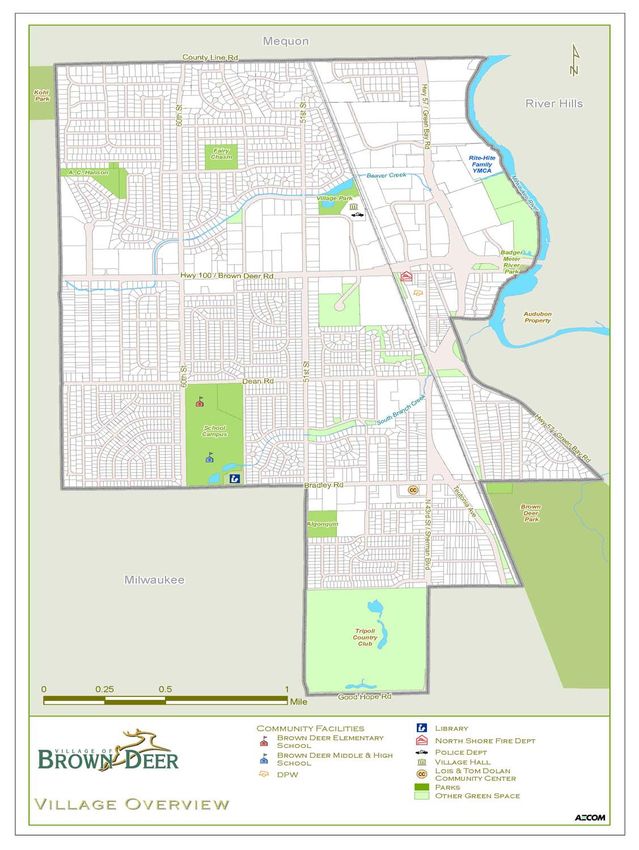
Table of Contents

Chapter One - Introducing the Comprehensive Outdoor Recreation Plan: Context, Purpose, and Scope

The Role of Parks and Recreational Facilities in the Village                                       7

Planning Needs, Parameters                                                                         7

Planning Context                                                                                   9

Amending the Plan                                                                                  9

Resolution Approving the Comprehensive Outdoor Recreation plan                                     11

Chapter Two - The Village of Brown Deer̶A Community Profile                                         12

Demographic Profile                                                                                 14

Housing                                                                                            16

Transportation                                                                                     17

Natural Resources                                                                                  18

Land Use                                                                                           21

Chapter Three - Parks and Recreation̶An Asset Inventory                                            22

Village Parks and Recreation Assets                                                                23

County Parks                                                                                       30

Recreational Programming                                                                           38

Chapter Four - Parks & Open Space Analysis: Classifications & Standards                             40

Mini-Parks/Pocket Parks                                                                            41

Neighborhood Parks                                                                                 42

Special Use Areas & Conservancies                                                                  44

Recreational Trails                                                                                45

Chapter Five - Park & Open Space Analysis: Quantity & Quality                                      48

Quantitative Assessment                                                                            50

Qualitative Assessment                                                                             52

Connection to the SCORP (Wisconsin STATE CORP)                                                     56

Future Needs Analysis                                                                              59

Chapter Six - Public Participation                                                                 60

Organizing Public Participation                                                                    61

Visioning Workshop/SWOT Analysis                                                                   61

4                       COMPREHENSIVE OUTDOOR RECREATION PLAN •VILLAGE OF BROWN DEER
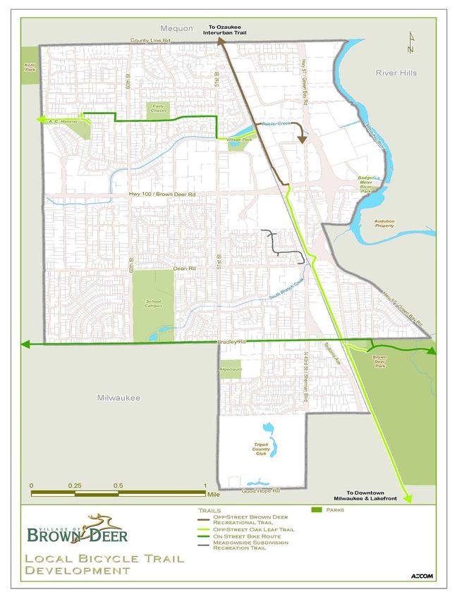
Table of Contents

Chapter Seven - Goals & Objectives                                                   64

Mission Statement                                                                    64

Definition of a Goal, Objective                                                       65

Listing of Community-defined Goals and Objectives                                     65

Chapter Eight - Recommendations                                                      68

Listing of Community-defined Goals, and Corresponding Recommendations                 69

Chapter Nine - Funding & Implementation                                              74

Implementation                                                                       75

Funding                                                                              76

APPENDICES                                                                           80

Appendix A: Capital Improvement Projects (Description & Documentation)               80

Appendix B: Links to Village, Regional, & State Plans                                81

Appendix C: Sources                                                                  83

Figures

Figure 1̶ Area Context                                                               8

Figure 2̶Village Overview                                                            13

Figure 3̶ Natural Resources                                                          19

Figure 4̶Conceptual Design for Brown Deer School District Master Plan                29

Figure 5̶A.C. Hansen Park                                                            30

Figure 6̶Algonquin park                                                              32

Figure 7̶Brown Deer Park                                                             35

Figure 8̶Kohl Park                                                                   37

Figure 9̶ Local Bicycle Trail Development                                            47

Figure 10̶Conceptual Site Plan for Badger Meter River Park                           49

Figure 11̶Brown Deer Parks & Open Spaces                                             53

                      COMPREHENSIVE OUTDOOR RECREATION PLAN •VILLAGE OF BROWN DEER       5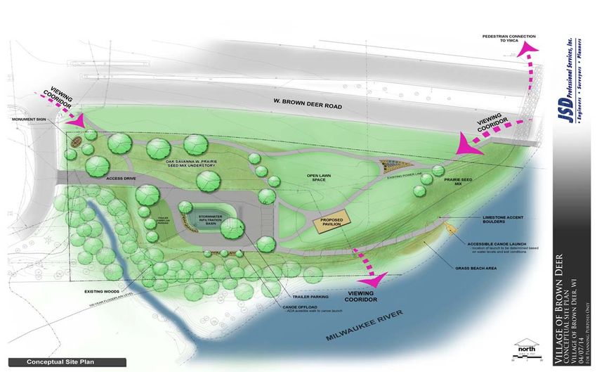
CHAPTER
Introducing the Comprehensive
Outdoor Recreation Plan:
Purpose, Context, and Scope

     P
                  arks and open space form an important component of       any community effort to meet

                  basic human needs for recreational and aesthetic wellbeing. They frame societyʼs

                  attempts to protect and enhance the natural environment and do much to shape the

     extent and pattern of community development. The following report is the Village of Brown Deerʼs

     Comprehensive Outdoor Recreation Plan (described hereafter as the “CORP”) for 2015-2020. This is

     the Villageʼs first such plan since incorporation in 1955. Its primary purpose is to guide the

     acquisition, preservation, and development of land for park, recreation, and related open space uses,

     to satisfy the needs of current and future residents, and to protect and enhance the underlying and

     sustaining natural resource base of the community. The 2015-2020 CORP was prepared in

     accordance with guidelines that make it certifiable by the State of Wisconsin Department of Natural

     Resources (DNR), and qualify the Village of Brown Deer for matching grant funds through the Federal

     Land and Water Conservation Fund (LAWCON) and the State of Wisconsin Stewardship Fund. The

     CORP shall be updated every five years to ensure that it reflects the current needs of the community,

     and to retain DNR certification.

6             COMPREHENSIVE OUTDOOR RECREATION PLAN •VILLAGE OF BROWN DEER
INTRODUCTION TO THE PLAN & PROCESS
The Role of Parks and Recreational Planning Needs, Parameters
Planning is key to the efficient execution of any program or
Facilities in the Village
priority. Good plans make the difference between cost-effective
Community Image – Local parks and recreational facilities investment, and costly crisis management. Plans establish
provide opportunities for formal and informal social interaction. organizational focus and direction, allowing stakeholders to align
Community festivals, organized recreational events and chance their interests and resources with those of the Village more
meetings between neighbors are but a few examples of the effectively and efficiently. They provide a framework for program
benefits of recreational programming that strengthen the social implementation, consistent decision-making, and serve as tools
fabric. A well-planned CORP can do much to brand a community with which to determine budgets and other support needs.
as a “nice” place to live, work, and play. Planning is a continuous process that follows a logical sequence
of steps. Four general questions drive the process, regardless of
Ecological Health (“rooms” & “hallways”) – In addition to plan type or complexity:
enhancing the physical health of residents, parks and open
spaces contribute to the greater ecological health of the Village. What assets and resources does the Village possess?
Local parks are often interwoven with environmentally sensitive What assets and resources does the Village need?
areas such as wetlands, floodplains, surface waters, or significant How will the Village meet goals to close these gaps?
woodlands. These areas also provide food and shelter for local How well is the Village plan succeeding at meeting these
wildlife and often supply the bulk of natural storm water goals?
retention. Individual parks can provide crucial “rooms” of natural
resource activity; however, they become even more functional
when they can be linked together by environmental corridors, or Planning Process & Description
“hallways”. Research at institutions like the University of Illinois
The plan, as designed:
Extension http://urbanext.illinois.edu/lcr/environmental.cfm)
1. Identifies and assesses the villageʼs existing parks, recreational
identified these corridors as crucial to the facilitation of the kind
facilities, and programming resources.
of “inter-room” movement several species need in order to
2. Identifies and recommends appropriate level of service
thrive.
standards for parklands and recreational facilities.
3. Presents the communityʼs priorities, needs, and aspirations as
Economic Prosperity – Leisure time and access to public
defined by stakeholders.
recreation assets are important components of peopleʼs lifestyles
4. Defines goals and objectives created to meet those needs and
and sense of wellbeing. The decision to choose a particular place
priorities.
to live is partially a function of the availability of nearby
5. Analyzes the degree to which the Village meets its stated
recreational amenities. Enhancing the Villageʼs ability to attract
goals, and makes recommendations to close defined gaps.
new residents creates direct economic benefits. The Robert Wood
6. Identifies and lists potential partners in the implementation of
Johnson Foundation, with assistance from San Diego State
these recommendations.
University, published a report concluding that property values
increase as distances from homes to park facilities decrease.
Additionally, municipal park assets that are managed and
planned in coordination with regional assets can serve to attract
visitors to the Village.
COMPREHENSIVE OUTDOOR RECREATION PLAN •VILLAGE OF BROWN DEER 7
INTRODUCTION TO THE PLAN & PROCESS

8   COMPREHENSIVE OUTDOOR RECREATION PLAN •VILLAGE OF BROWN DEER
INTRODUCTION TO THE PLAN & PROCESS
Planning Context Amending the Plan
The CORP incorporates information, principles, and priorities The Comprehensive Outdoor Recreation Plan (CORP) shall be
from past and present planning efforts at municipal, regional, reviewed each year after its initial establishment. It may be
state, and national levels. The following section lists those amended using the same process employed to create the CORP.
plans addressing park and recreational issues that overlap with It is recommended that the plans be updated at least once every
Brown Deerʼs planning priorities. five years in order for the Village to maintain eligibility for all
available funding opportunities, and to adequately reflect current
Village-scale Plans: Village park priorities.
Village of Brown Deer Comprehensive Plan 2030 Amendment of a CORP is a common occurrence and
Brown Deer Village and School District “Safe Routes To should be considered a normal part of the planning process. Plan
School” (SRTS) Plan (2010) amendments represent attentive implementation or plan usage
Village of Brown Deer Five-Year Capital Improvement and should be acceptable for consideration by local decision-
Plans makers. Amendments must follow the same process as the
Brown Deer School District Campus – Master Plan (2011) original Plan and should be developed in coordination with the
Community Services Department and Parks & Recreation
Adjacent Municipalities Department before presentation to the Village Board for
Public Outdoor Recreation Plan for City of Milwaukee approval. Well crafted, detailed amendments generally prolong
Neighborhoods (2001-2005) the effectiveness of the parent Plan.
Milwaukee Citywide Policy Plan: Natural Resources The Plan will make the Village eligible for funding
Mequon Nature Preserve “Preserve the Preserve” Program through the Wisconsin Department of Natural Resources through
City of Milwaukee Comprehensive Plan: Northwest Side the year 2020. Similarly, since this plan was developed with a
City of Milwaukee 2010 Bicycle Master Plan five-year timeframe in mind, it should be amended in 2020 to
ensure grant eligibility and to reflect progress achieved over this
Regional Plans: time period.
SEWRPC Planning Report No. 27: A Regional Park and
Open Space Plan for Southeastern Wisconsin – 2000
Amendment to the Regional Bicycle and Pedestrian
Facilities System Plan for Southeastern Wisconsin: 2020
(2001)
State & Federal Plans:
State of Wisconsin Comprehensive Outdoor Recreation
Plan, 2011-2016 (SCORP)
Americaʼs Great Outdoors (AGO) Initiative
COMPREHENSIVE OUTDOOR RECREATION PLAN •VILLAGE OF BROWN DEER 9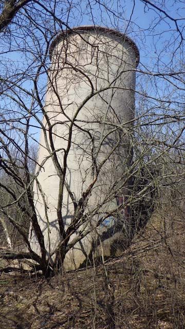
INTRODUCTION TO THE PLAN & PROCESS

10   COMPREHENSIVE OUTDOOR RECREATION PLAN •VILLAGE OF BROWN DEER
INTRODUCTION TO THE PLAN & PROCESS

COMPREHENSIVE OUTDOOR RECREATION PLAN •VILLAGE OF BROWN DEER   11
CHAPTER

                                                    The Village of Brown Deer:
                                                                             A Community Profile

     T
                 he Village of Brown Deer is an inner-ring suburb of the City of Milwaukee, located in north-

                 central Milwaukee County. The Village is bordered to the south and west by the City of

                 Milwaukee. It is bordered to the east by the Village of River Hills, and on its northern side by

     the City of Mequon. Its northern border forms part of Milwaukee Countyʼs border with Ozaukee County.

     The Village runs roughly 3 miles from North to South, and approximately 2 miles from East to West.

12                   COMPREHENSIVE OUTDOOR RECREATION PLAN •VILLAGE OF BROWN DEER
COMMUNITY PROFILE COMPREHENSIVE OUTDOOR RECREATION PLAN •VILLAGE OF BROWN DEER 13
COMMUNITY PROFILE

Demographic Profile
                                                                        Table 2-2: Population Trends, 1990-2020
Population Stability
                                                                                              1990         2000           2010        2014
In 1990, the U.S. Census recorded a Village population of 12,236
                                                                        Village of           12,236      12,170        11,999       12,067
residents. In 2000 and 2010 the U.S. Census recorded slight
                                                                        Brown Deer
declines to 12,170 and then 11,999 residents. Following recent

population gains since the last decennial Census count, the             Village of            1,612        1,631          1,597       1,501
                                                                        River Hills
population shrank less than 1.5%, from 1990-2014 (Table 2-2).

                                                                        City of              18,885       22,643       23,132       23,300
                                                                        Mequon
Age & Racial Distribution
The Village is both “urban” and “suburban”, in terms of age and         City of           628,088       596,974       594,833      598,078

racial distribution. With regard to age,     the Village reports a      Milwaukee

higher median age (42.9) than the City of Milwaukee (30.8) or           Milwaukee         959,275       940,164       947,735      953,401
Milwaukee County (34.0). It is significantly “younger” than              County

several suburban neighbors. The Village is “suburban” in terms of
                                                                        State of        4,891,769     5,363,675     5,563,896     5,724,692
the percentage of retirees in the population. Yet the Village is
                                                                        Wisconsin
also very different from neighbors like Mequon and River Hills, in
                                                                        Source: U.S. Census Bureau, 2010-2014 ACS 5-Year Est.
terms of the numbers of 20-44 year olds residing there (see

Table 2-1). With the average age of first-time homeowners and

parents falling within this cohort, this has significant ramifications
                                                                        Table 2-3: Race & Ethnicity, Percentage of Population
for future priorities regarding public recreation programming and
                                                                                                          %
investment. Regarding race, Brown Deer is the most diverse

Milwaukee suburb. The 2014 ACS recorded 32.8% of the Villageʼs                        White African Am.     Asian   Native Am. Hispanic

population as African-American. Approximately 4% of the Village
                                                                        Village of    84.3    1.9           8.5     0.5           (4.5)
identifies as “Hispanic” as well (see Table 2-3).
                                                                        River Hills

                                                                        Village of    57.7    32.8          3.1     0.3           (3.9)
                                                                        Brown Deer
Table 2-1: Age Distribution % by Age Group, 2014
                                                                        City of       93.0    2.6           2.7     0.3           (2.0)
                         0-19   20-44 45-64        65+    Median Age    Mequon
                                                               (Yrs.)
                                                                        City of       47.0    39.3          3.7     0.5           (17.7)
Village of River Hills   24.5     19.4    34.1     22.0         49.5    Milwaukee

Village of Brown         20.9    31.7    29.3 18.1             42.9     Milwaukee     62.1    26.4          3.6     0.6           (13.8)
Deer                                                                    County

City of Mequon           25.4     19.8    19.8     34.7         48.3    7 Original-   88.8    4.6           4.0     0.2           (2.8)
                                                                        Northshore
City of Milwaukee        30.5     38.4    21.6      9.2         30.8
                                                                        Suburbs
Milwaukee County         27.7     36.2    24.3     11.7         34.0
                                                                        State of      86.2    6.3           2.3     1.0           (5.9)
State of Wisconsin       25.9     31.9    27.9     14.4         38.8    Wisconsin

Source: U.S. Census Bureau, 2010-2014 ACS 5-Year Est.                   Source: U.S. Census Bureau, 2010-2014 ACS 5-Year Est.

14                       COMPREHENSIVE OUTDOOR RECREATION PLAN •VILLAGE OF BROWN DEER
COMMUNITY PROFILE
Educational Attainment
Brown Deerʼs educational attainment levels are consistent with
Table 2-4: Regional Employment & Participation
its “transitional” status between that of the City of Milwaukee and
Rates
that of its suburban neighbors. The Village occupies a “middle
ground” between the City of Milwaukee, where almost 19% of Workforce Unempl. Per Capita Poverty
adults (25 years or older) havenʼt completed high school, and Particip. Rate Income Rate
neighbors like River Hills, where roughly 77% of the population Rate Median
(household)
has a Bachelorʼs or Masterʼs Degree (see Table 2-5). The Village
has undertaken relatively heavy investment (over $22 Million in Village of
61.5% 4.5% $175,500 2.0%
bonds since 2011) into the local educational system, radically River Hills
remaking the Brown Deer School Campus, and working to Village of
improve coordination between educational investments and Brown 67.2% 5.0% $55,396 9.6%
development of outdoor recreation opportunities within the Deer
Village.
City of
60.5% 3.2% $106,813 3.5%
Mequon
Employment/Labor Force
City of
65.1% 8.5% $35,489 29.4%
The Village of Brown Deer has the highest workforce participation Milwaukee
rate in the Northshore region or Milwaukee. To some degree this
Milwaukee
reflects the lower median incomes in Brown Deer, relative to 66.0% 6.9% $43,385 21.9%
County
wealthier suburban neighbors like River Hills or Mequon. As more
State of
than one income earner is often needed to support a household 67.4% 4.9% $52,738 13.3%
Wisconsin
in Brown Deer. However, this higher workforce participation rate
Source: American Community Survey, 2010-2014 (5-year Estimate)
contributes to the lower unemployment rate in Brown Deer
(5.0%) than that observed in the City of Milwaukee (8.5%), and
the enormous difference between poverty rates in the Village
(9.6%), and that observed in the City of Milwaukee (29.4%).
Table 2-5: Educational Attainment, 2014 (For Residents 25 Years of Age or Older)
Degree
K-8 9-11 High School Some College Associates Bachelors Graduate
Village of River Hills 1.0% 0.5% 8.2% 9.1% 4.3% 37.0% 39.8%
Village of Brown Deer 1.3% 4.2% 22.9% 24.6% 8.4% 23.2% 15.4%
City of Mequon 0.3% 0.9% 14.0% 15.5% 5.5% 38.4% 25.5%
City of Milwaukee 6.7% 11.5% 30.2% 22.1% 6.7% 14.9% 7.9%
Milwaukee County 4.8% 8.9% 28.6% 21.5% 7.5% 18.6% 10.0%
State of Wisconsin 3.2% 6.0% 32.4% 21.1% 9.9% 18.1% 9.3%
Source: American Community Survey, 2010-2014(5-year Estimate)
COMPREHENSIVE OUTDOOR RECREATION PLAN •VILLAGE OF BROWN DEER 15COMMUNITY PROFILE
Housing
Table 2-6: Household Trends
Brown Deer bears the characteristics of a “transition” community,
where people (often from the City of Milwaukee) have been
attracted to Village amenities – quality schools, parks, security – Households/# Per Household (Proj.)
as well as the opportunity to transition from tenancy to
2000 2010 2014
homeownership. The demographic diversity reflected by these
Village of 590 2.76 595 2.68 692/2.77
statistics bear directly on the types of recreational priorities and
River Hills
choices contained in the CORP. One example is the higher
proportion of renters in Brown Deer. Renters often have fewer Village of 5,134 2.27 5,275 2.27 5,715/2.20
Brown Deer
immediate recreational choices than homeowners, which can
have an immediate effect on demand for public, outdoor, City of 7,861 2.75 8,598 2.56 9,906/2.51
recreational opportunities. Mequon
Tables 2-6 and 2-7 present household characteristics for City of 232,188 2.50 230,221 2.50 253,975/2.53
the Village, compared with neighboring areas. There appear to be Milwaukee
three tiers of municipalities in the greater Milwaukee region, in
Milwaukee 377,729 2.43 383,591 2.41 426,468/2.44
terms of homeownership versus renting. Brown Deer occupies
County
the middle tier with suburban neighbors like Glendale and
State of 2.0 Mil- 2.50 2.3 Mil- 2.43 2.5 Mil-
Menomonee Falls. However, Milwaukee County and City of
Wisconsin lion lion lion/2.43
Milwaukee neighborhoods adjacent to Brown Deer contain higher
percentages of renter households than that found in Brown Deer. Source: United States Census, WI Department of Administration
Median home values in Brown Deer remain lower than in
other suburbs, slightly higher than those reported for the City of Table 2-7: Household Characteristics, 2014
Milwaukee, and distinctly higher than the average for the two
Owners Renters Median Median
Milwaukee ZIP codes bordering Brown Deer. The average
Value Rent
household size in Brown Deer was 2.20 persons in 2014, below
City of Milwaukee 43.0% 57.0% $121,600 $784
its suburban neighbors, only slightly lower than the reading from
the 2000 Census. Milwaukee County 50.7% 49.3% $154,400 $802
Village of Brown
66.5% 33.5% $151,000 $905
Deer
City of Glendale 68.5% 31.5% $208,200 $1,015
Village of Me-
75.2% 24.8% $227,100 $914
nomonee Falls
Village of Bayside 81.6% 18.4% $325,600 $1,202
City of Mequon 87.0% 13.% $346,900 $1,307
Village of River Hills
98.2% 1.8% $619,900 NA
State of Wisconsin 69.5% 30.5% $165,900 $772
Source: American Community Survey, 2010-2014 (5-year Estimate)
16 COMPREHENSIVE OUTDOOR RECREATION PLAN •VILLAGE OF BROWN DEERCOMMUNITY PROFILE
Transportation Bus Transit
The Milwaukee County Transit System (MCTS) operates three bus
Roads & Highways
lines running through various parts of the Village. Route 76 runs
The Village is served by several county roads and two state
along N. 60th St. and west along W. Brown Deer Road. Route 12
highways. State Highway 57 (N. Green Bay Rd.) bisects the
runs along N. Teutonia Ave. and N. Green Bay Rd. to its terminus
Village in a north-south direction. It intersects State Highway 100
at Cherrywood Ln. The “Northshore Flyer” (route 49) also runs
(W. Brown Deer Rd.), the primary east-west artery. Bradley
along N. Green Bay Rd., connecting Village residents directly to
Road runs across the southern portion of the Village, intersecting
downtown Milwaukee.
County Highway “G” (N. Sherman Blvd.) and County Highway
“D” (N. Teutonia Ave.) in the southeast.
Table 2-9: Commuting Time (minutes)
Rail & Bicycle 2000 2014
The Village also contains rail and bicycle assets. The SOO Line/ Village of Brown Deer 21.2 21.6
Canadian Pacific line runs north-south, parallel to N. Green Bay
City of Milwaukee 22.5 22.1
Road. The Villageʼs Recreational Trail, that connects Milwaukeeʼs
Milwaukee County 21.9 22.2
Oak Leaf Trail to Ozaukee Countyʼs Interurban Trail., follows this
rail corridor. State of Wisconsin 20.8 21.8
United States 25.5 25.2
Transportation Mode Split Source: American Community Survey 2014
The 2014 American Community Survey recorded 251 residents
commuting to work either by foot or by “other means” besides
motorized vehicles. This represents 4.1% of the commuting
Village of Brown Deer Wayfinding Sign
population. The average Brown Deer commuter spent 21.6
minutes getting to work, in 2014. This is virtually unchanged
from the commuting time in 2000 (24 seconds).
Table 2-8: Transport Mode Split, Brown Deer, 2014
2000 % 2014 %
Drove Alone 5,435 85.5 5,113 83.2
Carpooled 603 9.5 467 7.5
Public Transit 53 0.8 130 2.1
Motorcycle NA NA 0 0.0
Bicycle NA NA 0 0.0
Walked 100 1.5 235 3.82
Other Means 52 0.8 16 0.30
Total 6,355 6,145
Source: U.S. Census Bureau, 2014 American Community Survey
COMPREHENSIVE OUTDOOR RECREATION PLAN •VILLAGE OF BROWN DEER 17COMMUNITY PROFILE
Natural Resources Topography
As is the pattern for most of Milwaukee County, Brown Deerʼs
Environmental Corridors
topography is primarily the result of glaciation occurring during
In their report titled “A Regional Natural Areas and Critical
the last Ice Age. The landscape is characterized by gently rolling
Species Habitat and Protection and Management Plan for
moraines. Development of the land to accommodate various land
Southeastern Wisconsin”, the Southeastern Wisconsin Regional
uses has altered much of the original terrain. The topography is
Planning Commission (“SEWRPC”) identifies environmentally
generally uniform, with one-to-six percent slopes the norm in
important areas for preservation efforts. In order to be classified
most areas. The elevation of the Village is approximately 676 feet
as a natural resource area, the area must have one or more of
above sea level.
the following: woodlands, wetlands, lakes, rivers, streams, steep
slopes, geological formations, wildlife habitat areas, poorly
Climate
drained soils, and existent or potential recreation sites. SEWRPC
The Village of Brown Deer receives 29 inches of rain per year, on
uses three categories to distinguish among natural areas of
average. The United States average is 37 inches. It receives 36
different scale and importance:
inches of snow per year, compared to a national average snowfall
of 25 inches. On average the Village enjoys 189 sunny days per
1. “Primary Corridors” are linear landscape features of at least
year, slightly below the national average of 205 days. The hottest
400 acres with a minimum length of two miles and a
and coolest months of the year are July and January,
minimum width of 200 feet.
respectively. The average high temperature in July is 82 degrees
2. “Secondary Corridors” are smaller in scale, with a minimum
Fahrenheit, and the average low in January is 13.8 degrees
of 100 acres and a minimum length of one mile.
Fahrenheit. The “Comfort Index”, which measures humidity
3. “Isolated Natural Resource Areas” have at least five acres
during hot months, places Brown Deer at 46, versus the national
with a minimum length of 200 feet.
average of 44, where a higher score means more “comfort”.
Within the Village of Brown Deer, there are three areas
Surface Water
that are considered “isolated natural resource areas”: the stand
Southbranch Creek and Beaver Creek, two tributaries of the
of oak trees behind the Bank Mutual headquarters south of
Milwaukee River, are the most important surface water resources
Brown Deer Road, the Tripoli Country Club grounds, and the
in the Village, according to the Southeastern Wisconsin Regional
stand of trees near A.C. Hanson Park.
Planning Commission (SEWRPC). The Milwaukee River comprises
Although largely located outside the Village (only 3.5
most of the Villageʼs eastern border with the Village of River Hills.
undeveloped acres are located within Brown Deer), much of
Other surface water resources identified by the regional planning
Brown Deer Park is designated a primary environmental corridor.
commission include the pond on the property of the Badger Meter
It is considered integral to the overall health of the regional
Corporation, located at 4600 W. Brown Deer Rd., and another
ecosystem. This park is widely used by Village residents and seen
pond on the property of the Tripoli Country Club, located at 7401
as an asset to the Village as well as the entire region. The
N. 43rd Street. In addition, a small portion of the Brown Deer Park
Milwaukee River corridor is also a primary environmental
Creek flows through the far southeastern corner of the Village.
corridor.
(Opposite: Figure 4 ̶
Natural Resources)
18 COMPREHENSIVE OUTDOOR RECREATION PLAN •VILLAGE OF BROWN DEERCOMMUNITY PROFILE COMPREHENSIVE OUTDOOR RECREATION PLAN •VILLAGE OF BROWN DEER 19
COMMUNITY PROFILE

Wetlands                                                                       Woodlands
The term “wetland” is used broadly to describe areas where the                 A woodland is loosely defined as an area populated with trees and

ground is saturated with water, primarily as a result of drainage              shrubs. Woodlands are smaller in size and less densely wooded

characteristics or proximity to surface water bodies. Because they             than forests. According to the SEWRPC, woodlands can exist

serve as an invaluable transition space between uplands and                    within an environmental corridor or alone. However, the title of

surface water, they often host an above-average endowment of                   “environmental corridor” is usually reserved for those woodlands

plant and animal species. Having been extensively “built-out”                  comprising at least 5 acres, and containing other natural features.

over the span of the previous half-century, Brown Deerʼs wetland               Areas described as woodlands are always smaller than those

resources are limited, as defined by the Wisconsin Department of                designated   environmental   corridors.   A   stand   of   trees,   for

Natural Resourcesʼ “Wisconsin Wetland Inventory”. The three                    example, may be classified as a woodland. Woodlands provide a

largest wetlands are located:                                                  viable habitat for birds and other animals. They also prevent soil
                                          st
· Adjacent to Algonquin Park, along 51 St.                                     erosion and their foliage removes carbon dioxide from the local

· Along Beaver Creek, just north of the Village Hall.                          air. The Village possesses several stands of trees that are smaller

· Near the new Donges Woods subdivision, just south of County                  than forests, yet fit the description of a woodland outlined by

     Line Rd.                                                                  SEWRPC and the Wisconsin DNR.

         Wetlands have been identified along the banks of the                   Flora, Fauna
Milwaukee River and in several locations along Beaver Creek,
                                                                               Because there are very few natural habitats left in the Village, no
Southbranch Creek, and within Brown Deer Park. They are
                                                                               endangered species have been surveyed or identified specifically
generally classified by the composition of the flora they contain.
                                                                               within Brown Deer. The North Shore suburbs, however, are home
Brown Deer contains forested, shrub, and wet meadow wetlands.
                                                                               to a variety of avian wildlife and small mammals common to
The Wisconsin Department of Natural Resources (DNR) maintains
                                                                               urban areas, including songbirds, deer, foxes, rabbits, squirrels,
an online mapping service that can be referenced for more
                                                                               and chipmunks. The Village of Brown Deer was recently
information about wetlands.
                                                                               recognized for efforts to protect avian species, and has enjoyed

                                                                               recognition as a “Bird City” for three consecutive years now.
Soils
According to the SEWRPCʼs soil mapping service, Brown Deer

possesses   approximately     a   dozen        different   soil    types   in

abundance, belonging almost exclusively to the “silt loam”

category. Silt loams are characterized by a relatively high

proportion of granular material. They are not ideal for agricultural

purposes owing to poor drainage characteristics.

         The following soils are known to exist within Brown

Deer in significant quantities: Ozaukee Silt Loam, Mequon Silt

Loam, Ashkum Silt Loam, Martinton Silt Loam, Colwood Silt

Loam, Clayey Silt Loam, Casco Silt Loam, Grays Silt Loam, Fox

Sandy Loam, Montgomery Silty Clay, and Pella Silt Loam.

20                     COMPREHENSIVE OUTDOOR RECREATION PLAN •VILLAGE OF BROWN DEER
COMMUNITY PROFILE
Land Use
Current Land Use Patterns Future Land Use Patterns
Village land usage encompasses a range of residential, In outdoor recreation and open space planning, the location of
commercial, industrial, and public development. Single-family future residential development is very important, especially when
residential development is dispersed throughout the planning future park locations. Brown Deer is not expected to
northwestern, southwestern, and southeastern quadrants of the experience significant growth in population between 2013 and
Village. Extensive pockets of multi-family unit developments are 2040. Changes in population within the Village will likely reflect
located in the northeastern section of the Village. Large clusters changes in concentration or density rather than any “net” growth
also exist at the western end of the Village, and in the south of in the number of total residents. Even though the total population
the Village, along Bradley Road. Extensive commercial is not growing, changes within the Village are still occurring.
development is concentrated in the northeastern quadrant of the Below is a list of areas that may experience land use changes in
Village and along larger roads. Notable examples include the the short and long term:
Marketplace of Brown Deer at the intersection of state highways
57 and 100, the Original Village District just southwest of the Potential Changes in the Short-Term (0-2 years):
intersection of W. Brown Deer Rd. and N. Green Bay Rd., the · Beaver Creek residential redevelopment.
Bradley Plaza and Bradley Village areas along W. Bradley Rd., · Redevelopment of commercial land along W. Bradley Road, from
and the Brown Deer Center at the Villageʼs western end. 51st Street to Teutonia Avenue.
Significant office space, is concentrated within the Brown Deer
and Opus North business parks in the Villageʼs northeastern Potential Changes in the Long-Term (2+ years):
quadrant. Industrial uses are concentrated along W. Brown Deer · Potential for Mixed-use development along Green Bay Road.
Rd. and within Brown Deer Industrial Park. · Increasing residential density in the Original Village District area.
Public parks are dispersed throughout the Village. · Residential redevelopment of the Stange Greenhouse site
Governmental uses for land are centrally located, for the most · Redevelopment of the Bank Mutual business park, and land
part. The Village Hall, Police Department, North Shore Health along the southern side of W. Brown Deer Rd., from 64th St.
Department, and Village Park are clustered together centrally, to 68th St.
just north of W. Brown Deer Rd. The Brown Deer Municipal
Complex & Recycling Center and the North Shore Fire
Department are nearby, on the southern side of W. Brown Deer
Rd. Agricultural use of the land has virtually disappeared. The
Village is now largely built out, and few acres of virgin land
remain for development.
COMPREHENSIVE OUTDOOR RECREATION PLAN •VILLAGE OF BROWN DEER 21CHAPTER
Parks and Recreation:
An Asset Inventory
T
he Village of Brown Deer owns and operates two municipal parks, totaling 21 acres in size.
The Village also offers a multi-purpose linear trail and several recreational amenities at the
Brown Deer School Campus, which occupies 63.8 acres. The multi-use/recreational trail
links the Ozaukee Interurban Trail and the City of Milwaukeeʼs Oak Leaf Trail. Milwaukee County also
operates A.C. Hanson Park and Algonquin Park, which provide an additional 23 acres of space. The
Village is also currently in the process of creating a 2.6-acre park and canoe launch that will allow the
public unprecedented access to the Milwaukee River.
22 COMPREHENSIVE OUTDOOR RECREATION PLAN •VILLAGE OF BROWN DEERNATURAL & RECREATION ASSET INVENTORY
Village Parks and Recreation Assets: Future Park Assets
The Milwaukee County Park System (the top-rated park Badger Meter River Park
management system in the United States in 2010) also operates
The Villageʼs Comprehensive Plan called for greater public access
Brown Deer Park. While only 3.5 acres lie within Brown Deer, the
to the Milwaukee River. As part of this effort the Village recently
park provides 363 acres for open space and recreational uses,
completed the purchase of 2.6 acres of excess right-of-way at the
immediately adjacent to the Village. The county system also
southeast corner of W. Brown Deer Rd. & N. Kildeer Ct. The
operates Kohl Park, which borders the Village to the northwest
property also features hundreds of feet of Milwaukee River
and provides an additional 275 acres for open space and
frontage. The Village intends to create a universally accessible,
recreational uses. These assets allow residents relatively easy
non-motorized boat launch on the site with other passive
access to over 745 acres of open space for recreational uses.
recreation. This site may also serve as a key linkage to a larger
While largely located outside of the Village boundaries, both Kohl
publicly accessible green space system linking natural areas to the
Park and Brown Deer Park will be utilized in the overall needs
east (in River Hills) and north, as envisaged in the URS-led Sub-
analysis in Chapter 5.
Area Plan “North River Corridor”. This facility will be known as
A private non-profit group, the River Revitalization
Badger Meter River Park.
Foundation (RRF) owns 2.2 acres of land that is permanently
deed restricted to allow public access. The site features a walking
path from the adjacent Oak Leaf Trail to enjoy passive
recreational pursuits. Finally, the Tripoli Country Club is a private
recreation site within the Village which is not factored into the
needs analysis.
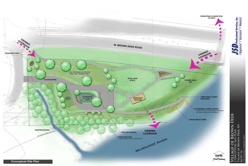
Badger Meter River Park
Boat Launch
COMPREHENSIVE OUTDOOR RECREATION PLAN •VILLAGE OF BROWN DEER 23NATURAL & RECREATION ASSET INVENTORY
VILLAGE PARK The Historic Little White Schoolhouse (1884)
This 10.8-acre park is located in the northeastern
part of the Village (see Figure 6, on page 23). It is
surrounded by several significant municipal structures
and natural resources, including the Village Swim
Pond, the Historic Little White School House, Beaver
Creek, the Brown Deer Recreational Trail, and Village
Hall. The park itself includes areas for both passive
and active recreation. Its large commons area and
two large, outdoor pavilions make it an ideal setting
for larger private gatherings and several public
events. These include: the Villageʼs 4th of July
commemoration, the Community Vibes Concert
Series, and the National Night Out celebration,
among others. In terms of physical equipment and
assets, the park itself contains:
2 open-air shelters
The Brown Deer Swim Pond & Bathhouse
Restroom facilities
1 concession stand
1 sand volleyball court
Chemical building for pond operation
2 play structures (including 1 Tot Lot)
1 sledding hill
1 Oak Leaf Trail spur (connecting the Brown Deer
Recreational Trail to 51st St.)
The Historic Little White School House (1884)
1 Bubbler
1 Bicycle Rack (seasonal)
Changing rooms
Staff area
24 COMPREHENSIVE OUTDOOR RECREATION PLAN •VILLAGE OF BROWN DEERNATURAL & RECREATION ASSET INVENTORY
One of two
Outdoor Pavilions
The Swim Pond
& Bathhouse
The Historic Little
White Schoolhouse
COMPREHENSIVE OUTDOOR RECREATION PLAN •VILLAGE OF BROWN DEER 25NATURAL & RECREATION ASSET INVENTORY
FAIRY CHASM PARK
Before recent redevelopment of Brown Deerʼs
School Campus took place, this was the Villageʼs
primary public athletic facility. Several youth
soccer, baseball, and basketball teams call this
park their home field. The park also contains
playground facilities for children of all ages.
This 10-acre park is located in the
northern part of the Village, roughly one half-mile
to the west of Village Park, and roughly one half-
mile east of A.C. Hanson Park (see Figure 2 on
page 11). These three parks are connected by the
Oak Leaf Trail, which runs past Fairy Chasm Parkʼs
southern side along Fairy Chasm Road. The parkʼs
design reflects an emphasis on youth team sports
activities. The park houses a basketball court,
three soccer fields, two baseball/softball diamonds,
and a larger modular playground facility. The park
is used by the Parks and Recreation Department
for organized sports programs throughout the
year. In terms of physical equipment and assets,
the park itself contains:
1 Baseball Diamond (90ʼ, fenced, with bleachers)
1 Softball Diamond (60ʼ, with bleachers)
1 Soccer Pitch (40-Yard, U8)
1 Soccer Pitch (70-Yard, U10)
1 Soccer Pitch (90-Yard, U14)
1 Bubbler (“Drinking Fountain”)
1 Playground Facility
1 Bicycle Rack
Asphalt parking lot
In-ground sprinkler systems
Restroom Facilities
1 Basketball Court
42 Parking Spots (1 handicapped)
4 Trash Receptacles
2 Park Benches (3-Yard)
26 COMPREHENSIVE OUTDOOR RECREATION PLAN •VILLAGE OF BROWN DEERNATURAL & RECREATION ASSET INVENTORY
Basketball
Court
Playground
Facility
U8, U10, U14
Soccer Fields
COMPREHENSIVE OUTDOOR RECREATION PLAN •VILLAGE OF BROWN DEER 27NATURAL & RECREATION ASSET INVENTORY
Most of these resources are available for public use on a daily
basis. They include:
THE BROWN DEER SCHOOL A network of walkways and paths (“spines”) allowing
CAMPUS pedestrians to cross the campus on foot in all four cardinal
directions
Tall grass plantings along the creek that absorb sound, attract
wildlife, reduce wind speed, and provide educational
opportunities for students.
3 soccer pitches (1 regulation-size, 2 practice fields)
Bicycle paths and racks
427 parking spaces (16 handicapped)
3 baseball diamonds (1 High-School Regulation, 2 “skinned ball”
fields)
1 high school football field
1 outdoor running track (1600m, 8-lane)
7 tennis courts
2 playground facilities (elementary school)
1 outdoor geology garden
1 outdoor WorldTrail fitness path
2 basketball courts
1 disc golf course
1 sledding hill
3 sand volleyball courts (under construction)
This is a good place to briefly, but effec vely, Indoor facilities include: gymnasia, climbing wall, a workout
describe your product or services. room (treadmills, free weights, weight machines, locker
The Brown Deer School District Campus covers 63 rooms), a swimming pool, indoor track, basketball courts.
acres of land in the southwest quadrant of the Several plantings of flora specifically designed to enhance the
Village. In addition to forming the core of Brown areaʼs attractiveness to native bird species (Cornelian-Cherry
Deerʼs educational infrastructure, the newly Dogwood, Columnar Flowering Crabapple trees, Rattlesnake
redesigned campus will provide substantial outdoor Master)
recreational assets for use by the entire
community. The reconfiguration of school district
facilities has created the largest contiguous green
space entirely within the Villageʼs borders.
28 COMPREHENSIVE OUTDOOR RECREATION PLAN •VILLAGE OF BROWN DEERNATURAL & RECREATION ASSET INVENTORY
Figure 4: Brown Deer School District Master Plan Conceptual Design
COMPREHENSIVE OUTDOOR RECREATION PLAN •VILLAGE OF BROWN DEER 29NATURAL & RECREATION ASSET INVENTORY
County Parks
A.C. Hanson Park
This 13.5-acre park is located in the northwestern part of the The park features:
Village (see Figure 11, on page 55). Like Village Park, it also · 1 Modular Playground Facility
contains a large commons area and a modular playground Meadow/Commons
facility. It is located in a residential area, isolated from major Woodlands (SEWRPC-Designated Natural Area)
roads. To the north, west, and east of the park, it is surrounded Isolation from major roads
by single-family residences. To the west, however, it adjoins Physical connection to Milwaukee County park system (Kohl
woodlands that connect to the City of Milwaukeeʼs Kohl Park. The Park, Oak Leaf Trail)
Oak Leaf Trail runs through the northern end of A.C. Hanson Park Oak Leaf Trail spur connecting to future Kohl Park trails
to connect to Kohl Park.
Figure 5: A.C. Hanson Park
#3
#1
#2
30 COMPREHENSIVE OUTDOOR RECREATION PLAN •VILLAGE OF BROWN DEERNATURAL & RECREATION ASSET INVENTORY
#1: Oak Leaf
Trail, heading into
woodlands
adjoining Kohl
#2: Eastern
entrance to A.C.
Hanson Park,
Facing woodlands
#3: The northern
entrance to the
park (from W.
Pierner Place)
COMPREHENSIVE OUTDOOR RECREATION PLAN •VILLAGE OF BROWN DEER 31NATURAL & RECREATION ASSET INVENTORY
Algonquin Park
The park features:
This 9.4-acre park is located in the south-central part of the
Village (see Figure 6, on page 23). This park provides green
Park building
space and outdoor recreation options for many residents of the
Play structure
southern end of the Village who would otherwise find it difficult to
Baseball field
walk to or access the Brown Deer School Campus, Brown Deer
Adjoining woodland area (with lit trail)
Park, or the Tripoli Country Club grounds. Residents can access
Soccer field
the park and adjoining woodlands from six separate points. The
Wading pool
park is a crucial green space for elderly residents, with three
Paved Walking Path
major senior housing centers located within a 1/4-mile of the
Restrooms/concession stand
park.
Benches
Figure 6: Algonquin Park
#1
#2
#3
32 COMPREHENSIVE OUTDOOR RECREATION PLAN •VILLAGE OF BROWN DEERNATURAL & RECREATION ASSET INVENTORY
#1:
Northwestern
entrance into
Algonquin Park
from N. 51st
#2: County
facility and
playground
adjoining
woodlands
#3:
Woodland path
along southern
side of the park
COMPREHENSIVE OUTDOOR RECREATION PLAN •VILLAGE OF BROWN DEER 33NATURAL & RECREATION ASSET INVENTORY
Cross Country Skiing
BROWN DEER PARK
Brown Deer Boathouse Pavilion
The Boathouse Pavilion pictured above has been
discussed as a possible location for a community
Biergarten, modeled after the successful effort to
re-establish the Milwaukee Biergarten tradition in
Shorewoodʼs Estabrook Park. Milwaukee County
recently also extended a paved trail alongside the
western border of the park that connects cyclists
to the Brown Deer Recreational Trail.
This 362.5-acre park is one of the gems
of the Milwaukee County park system. Most of the
park is located within the borders of the City of
Milwaukee, and not the Village of Brown Deer.
Nonetheless, it forms an important component of
the outdoor recreation environment for Village
residents, especially those in the southeastern
quadrant.
Golf Course & Amenities
34 COMPREHENSIVE OUTDOOR RECREATION PLAN •VILLAGE OF BROWN DEERNATURAL & RECREATION ASSET INVENTORY
Figure 7: Brown Deer Park
COMPREHENSIVE OUTDOOR RECREATION PLAN •VILLAGE OF BROWN DEER 35NATURAL & RECREATION ASSET INVENTORY
Hiking trail̶Kohl Park
KOHL PARK
Brown Deer Park provides residents with an enormous range of
outdoor recreation and green space options, including:
A portion of the Oak Leaf Trail (paved, multi-use)
18-hole golf course, clubhouse, & driving range
Boathouse & Pavilion
2 softball diamonds
2 soccer fields
An old silo slowly overgrown by Kohl Park
1 football practice field
1 disc-golf course
2 sand volleyball courts
Sledding
Thishill275-acre
(seasonal)
park, also run by the Milwaukee
Modular Playground
County Facilities is
Park System, located entirely outside
X-country
the skiing trails (seasonal)
boundaries of the Village of Brown Deer.
4 tennis courts (with
However, parking)the
it borders western edge of the
8 reservable
Village.picnic
Its areas
master plan has never been
Over 160 picnic tables
implemented due to budgetary constraints at the
“Exceptional
county Native-Plant
level. Some Community”
work hasdesignation
already been
Pond completed, however. Several miles of trail have
been cleared, drainage structures have been
built, signage including kiosks are in place, and
several scout troops and student volunteers
perform regular maintenance on the park grounds
to inhibit invasive species and to keep trails clear.
Long term plans include the extension of the Oak
Leaf Trail into and through the park. When the
master plan is eventually implemented, this park
will provide substantial recreational and open
space access, at a scale similar to that of Brown
Deer Park.
36 COMPREHENSIVE OUTDOOR RECREATION PLAN •VILLAGE OF BROWN DEERNATURAL & RECREATION ASSET INVENTORY
Figure 8: Kohl Park
COMPREHENSIVE OUTDOOR RECREATION PLAN •VILLAGE OF BROWN DEER 37NATURAL & RECREATION ASSET INVENTORY
RECREATIONAL
PROGRAMMING
Events like the July 4th Parade pictured above are
just one part of an array of opportunities the
Village provides for residents to maximize their
recreational options. Village programming allows
residents to enjoy the great outdoors, yet also
allows them to enjoy indoor recreation activities
when the weather or season does not permit
many popular outdoor activities. It also creates
educational and fitness opportunities for children,
families, the elderly, and the physically disabled. Recreational Programming
Brown Deer Youth Football
The Villageʼs Park & Recreation
Department is responsible for the development
and operation of recreation programs and park
facilities in Brown Deer. Most classes and
programs are subsidized for residents. Sessions
usually last a few weeks and are flexibly
scheduled to accommodate work hours and
school schedules. Below is a listing of the types of
recreational programming options and “sessions”
available to Village residents (Table 3-1).
Brown Deer Swim Pond
38 COMPREHENSIVE OUTDOOR RECREATION PLAN •VILLAGE OF BROWN DEERNATURAL & RECREATION ASSET INVENTORY
The Deer Run (Participants can run or walk either 5k or 10k. Runners start and end at Village Park, running
through residential neighborhoods within Brown Deer.)
Table 3-1: Recreational Programming
Category Activity
Youth Enrichment Dance lessons, piano lessons, drama class, parent and child art classes, babysitter
training, various playground-centered activity camps
Youth Sports Soccer, baseball, softball, T Ball, basketball, track and field, football, flag football,
volleyball, tennis, golf, swimming, day camps
Adult Programs Dance aerobics, toning with hand weights, yoga, ballroom dance classes, Zumba, disc
golf, and adult swimming lessons.
Older Adult Programs/Events Senior Citizens Club, AARP driver safety training, Senior Exercise, carving.
Family Programs Babysitter training, parent/child art classes, Parentʼs Class for parents with Teenage
Drivers, Family Movie Night at Village Park
Community Events Family Movie Night, Night Out for Justice, Community Vibes, 4th of July celebration,
National Night Out, the annual “Deer Run”
COMPREHENSIVE OUTDOOR RECREATION PLAN •VILLAGE OF BROWN DEER 39CHAPTER
Parks & Open Space Analysis:
Definitions, Terms, & Classifications
I
n order to help guide the park planning process, it is important to identify standards that
can serve as benchmarks to evaluate the adequacy of Village parks. The Village uses
standards created by the National Recreation & Park Association (NRPA) to guide the
determination of park requirements. These standards enable a community to determine how well its
existing recreational facilities meet the needs of residents at the present time, as well as allowing
planners to project future needs for such facilities. These standards are typically expressed as a
population ratio (minimum number of acres recommended per 1,000 persons). The NRPA
recommends that a communityʼs park system be composed of a “core” system of parklands, with a
total of 6.25 to 10.5 acres of developed open space per 1,000 residents. This standard suggests that
the Village needs between 75 and 125 acres of developed open space. It should be noted that while
such standards provide acceptable target guidelines for the provision of parks and open spaces, a
more thorough and accurate analysis of the Villageʼs park system must emphasize local demand and
historic expectations for recreational resources. The following profiles describe each typical park
system component and provide examples of each type of park.
40 COMPREHENSIVE OUTDOOR RECREATION PLAN •VILLAGE OF BROWN DEERPARK CLASSIFICATIONS & STANDARDS
Mini-Parks/Pocket Parks
General Description: These parks offer specialized facilities that
serve a centralized, concentrated or specific group such as young
children or senior citizens.
Service Area: Less than ¼ mile in residential areas
Desirable Size: 1 acre or less
Acres per 1,000 Population: .25 to .5 acres
Basic Facilities and Activities:
Playground equipment and structures for preschool and
elementary school age children
Conversation and sitting areas arranged to permit easy
surveillance by parents
Landscaped areas that provide buffering and shade
Lighting for security at night (cut-off, fixtures)
Parking not typically provided
Desirable Site Characteristics:
Suited for intense development
Easily accessible to the neighborhood population
Centrally located in close proximity to residential development
Accessible by walking or biking
Well buffered by open space and/or landscape plantings, often
separated from roadways by barriers such as fences
Village of Brown Deer Mini-Park/Pocket Parks:
(None)
Below: Example of a Pocket Park (Santa Monica, California )
COMPREHENSIVE OUTDOOR RECREATION PLAN •VILLAGE OF BROWN DEER 41PARK CLASSIFICATIONS & STANDARDS
may also feature areas of natural quality for activities such as
Neighborhood Parks
walking, biking, and viewing that are supported by trail systems.
General Description: These parks are designed specifically to
accommodate residents living within the immediate surrounding
Service Area: 1 to 2 mile radius (several neighborhoods)
area. They are often characterized by active recreational facilities
Desirable Size: 25+ acres is desirable
such as baseball and soccer fields, but should also incorporate
Acres per 1,000 Population: 5.0 to 8.0 acres
some passive recreational areas for picnicking and nature study.
Basic Facilities and Activities:
Service Area: ¼-to-½ mile radius uninterrupted by non-local
Active recreational facilities (areas for swimming and boating,
roads and/or other physical barriers
biking/walking/skiing trails, playfields, playgrounds, sport
Desirable Size:
courts)
· “Small”: 1-5 acres;
Passive recreational facilities (walking trails, picnic/sitting,
“Large”: 5-10 acres
nature study areas)
Acres per 1,000 Population: 1.0 to 2.0 acres
Service buildings for shelter, storage, restrooms
Facilities for cultural activities (plays and concerts in the park,
Basic Facilities and Activities:
etc.)
Active recreational facilities such as playfields, tennis courts,
Buildings with multi-use rooms for crafts, theatre, restrooms,
basketball courts, playgrounds, ice-skating rinks
social activities, older adult use
Passive recreational facilities (picnic/sitting, nature study areas)
Lighting for night-hour security, adequate off-street parking
Service buildings for shelter, storage and restrooms
Lighting for security at night
Desirable Site Characteristics:
Adequate on-street and off-street parking
May include natural areas, such as bodies of water or wooded
Not intended to be used for activities that result in overuse,
natural areas
noise, and increased traffic with exception of limited use by
Easily accessible to the neighborhood population
youth teams
Accessible by walking or biking
Desirable Site Characteristics:
Village of Brown Deer Community Parks:
Easily accessible to the neighborhood population
A.C. Hanson Park (12.8 acres)
Accessible by walking or biking
Brown Deer School Campus (63.8 acres)
Village Park (10.8 acres)
Village of Brown Deer Neighborhood Parks:
Brown Deer Park (362.6 acres; It lies mainly within the City of
Algonquin Park: 9.1 acres
Milwaukee, but provides substantial recreation opportunities
Fairy Chasm Park 10.1 acres
to the community. It is easily accessible to thousands of
Village residents.)
Community Parks Kohl Park (270 acres; This park is technically outside the
General Description: These parks have areas of diverse Village, wholly within the borders of the City of Milwaukee.
environmental quality. They may include areas for intense However, like Brown Deer Park, it adjoins the Village. It is a
recreational facilities, such as athletic complexes for organized younger park, and many recreation projects remain
sports, large group picnicking, and community gatherings. They incomplete. However, when complete, this park will
42 COMPREHENSIVE OUTDOOR RECREATION PLAN •VILLAGE OF BROWN DEERPARK CLASSIFICATIONS & STANDARDS
probably provide substantial recreation opportunities for Acres per 1,000 Population: Variable - most Linear Park areas
residents of the northwest corner of the Village at a scale are not included in the overall community calculation of park and
similar to those that southeastern Village residents derive recreation space per 1,000 persons.
from Brown Deer Park.)
Desirable Design Criteria for Multi-Use Paths:
Linear Parks
Minimal width of 10 feet to accommodate two-way bicycle
General Description: Linear parks accommodate various outdoor
traffic, and recommended paved surface to facilitate biking,
activities, such as biking, hiking, walking, jogging, nature study,
walking, running, and other active recreational pursuits.
and cross country skiing. A well-designed park system provides
Avoid placement alongside roadways where multiple cross-
connections between parks and open space lands through the use
street and driveways are or will be present.
of linear park areas. Linear parks can be designed to serve
different functions and to accommodate various, and sometimes
Desirable Design Criteria for Walking/Hiking Trails:
conflicting activities.
Because these trail facilities often travel through
environmentally sensitive areas, they are generally not
Service Area: Variable - depends on length & size
paved. Rather, they are surfaced with crushed limestone,
decomposed granite, wood chips, hard packed earth or
Desirable Size: Sufficient width to protect the resource and
mowed grass.
provide maximum use.
Village of Brown Deer Linear Parks: (None)
Example of a linear park (San Antonio, Texas)
COMPREHENSIVE OUTDOOR RECREATION PLAN •VILLAGE OF BROWN DEER 43You can also read