GUIDE FOR SAILBOATS & MOTOR BOATS - Montenegro & Croatia/ Dubrovnik-Neretva County
←
→
Page content transcription
If your browser does not render page correctly, please read the page content below
Cross-Border
                                                                                   Programme
                                                                         Croatia - Montenegro

This Project is funded                            Joint Promotion and Increased Level of Safety of Nautical Tourism
by the European Union                             in Dubrovnik-Neretva County and Montenegrin Coast

              GUIDE FOR SAILBOATS
                & MOTOR BOATS
                              Montenegro &
                    Croatia/ Dubrovnik-Neretva County

                               www.nautour.info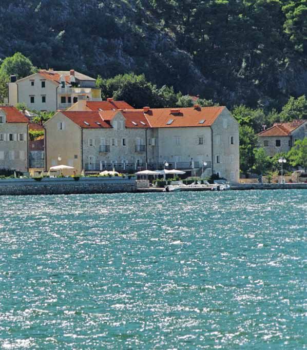
European Union- IPA Cross-Border Programme Croatia-Montenegro

                           This Project is funded by the European Union.
                           This publication was produced with the financial assistance of the European Union.
                           The contents of the document do not necessarily reflect the positions of the European Union.

                      Photographs by Ljubo Gamulin have been obtained as part of the “NauTour” project activity
                                         implementation, financed by the European Union.

                 Texts by Radovan Marčić have been prepared as part of the “NauTour” project activity implementation,
                                                 financed by the European Union.

                                                           Publisher:
                                          National Tourism Organisation of Montenegro

                                                               Editors:
                                            National Tourism Organisation of Montenegro
                                  Institute for Hydrometeorology and Seismology of Montenegro
                                          Hydrographic Institute of the Republic of Croatia
                                           University of Dubrovnik (Maritime Department)

                                                          Design and press:
                                                  Biljana Živković – Studio Mouse

                                                            Circulation:
                                                               2000

                                                            Published:
                                                              2012.

                                                     ISBN 978-953-6165-59-9

   The project is implemented by the Hydrographic Institute of the Republic of Croatia and Institute for Hydrometeorology and
Seismology of Montenegro in partnership with the University of Dubrovnik and the National Tourism Organisation of Montenegro.
Contents

About the project ........................................................................................4                      Island Lokrum .............................................................................................. 30
Introduction......................................................................................................5              Župa bay.......................................................................................................... 30
Info map of the Dubrovnik-neretva county                                                                                         Cavtat ................................................................................................................ 31
and the Montenegrin coast....................................................................6                                   Šunj bay / lopud island.......................................................................... 32
Basic information: Montenegro............................................................8                                       Šipan bay / šipan island......................................................................... 32
Basic information Republic of Croatia /                                                                                          Harpoti canal ................................................................................................ 33
Dubrovnik-neretva county......................................................................9                                  Slano .................................................................................................................. 33
Montenegro................................................................................................... 10                 Pelješac ............................................................................................................ 33
Boka Kotorska .............................................................................................. 10                               Ston ............................................................................................... 33
                 Herceg Novi, Boka bay ...................................................... 10                                               Kobaš ............................................................................................ 34
                 Zelenika, Boka bay ............................................................... 12                           Mali and Veliki Vratnik, passages ...................................................... 34
                       Map of Boka Kotorska ................................................. 12                                 Mljet island..................................................................................................... 34
                       Map of Zelenika ............................................................. 12                                       Saplunara bay........................................................................... 34
                 Tivat, Boka bay ........................................................................ 13                                  Sobra / Mljet island............................................................... 35
                 Kotor, Boka bay ...................................................................... 14                                    Polače / Mljet island.............................................................. 35
                 Perast, Boka bay ..................................................................... 15                                    Pomena / Mljet island.......................................................... 35
                 Risan, Boka bay ....................................................................... 16                      Lastovo Island............................................................................................... 36
                 Žanjice, cove ............................................................................ 17                                Zaklopatica ............................................................................... 36
                 Trašte, cove .............................................................................. 17                               Velji Lago .................................................................................... 36
                 Bigova, cove ............................................................................ 18                                 Ubli ................................................................................................. 37
Budva ................................................................................................................ 18                     Lastovnjaci ................................................................................. 38
                 Bečići ............................................................................................ 19           korčula island.............................................................................................. 38
                 Sveti Stefan ............................................................................... 20                              Korčula.......................................................................................... 38
                 Petrovac ...................................................................................... 20                           Brna ................................................................................................ 39
                 Pečin, cove................................................................................. 21                              Port Karbuni ............................................................................. 40
Map of Bar....................................................................................................... 22                          Proizd island / Vela luka bay,
Bar ....................................................................................................................... 23                Korčula island .......................................................................... 40
Valdanos, cove.............................................................................................. 24                               Vela luka ...................................................................................... 40
Ulcinj ................................................................................................................. 24      Pelješac............................................................................................................. 42
                 Ada Bojana, mouth of the Bojana river .................. 25                                                                  Lovište .......................................................................................... 42
Republic of Croatia /                                                                                                                         Trstenik / Žuljana bay ......................................................... 43
Dubrovnik-neretva county................................................................... 27                                                Žuljana bay .............................................................................. 45
Dubrovnik ...................................................................................................... 27              Information on institutions participating in the
                 Port of Gruž .............................................................................. 27                  Project – montenegro............................................................................. 50
                 ACI marina “Miho Pracat”,                                                                                       Information on institutions participating in the
                 Rijeka dubrovačka, Komolac .......................................... 28                                        Project – republic of croatia............................................................... 52
                 Dubrovnik / old city port.................................................. 28

                 3                  For informative purposes only. This Guide is not intended to be used in navigation
                                    and cannot be used instead of official nautical charts and navigation publications.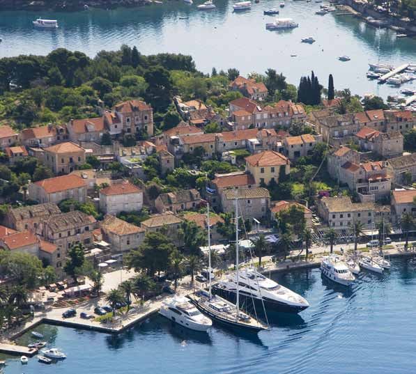
Cross-Border
                                                                                                            Programme
                                                                                                  Croatia - Montenegro
                                                           This Project is funded
                                                                                           www.nautour.info
                                                          by the European Union

“JOINT PROMOTION AND INCREASED LEVEL OF SAFETY OF NAUTICAL TOURISM IN DU-
BROVNIK-NERETVA COUNTY AND MONTENEGRIN COAST” –”NAUTOUR”
IPA – CROSS-BORDER PROGRAMME CROATIA-MONTENEGRO

ABOUT THE PROJECT
Through its funds and programmes, the European Union                 border area
(EU) provides assistance to different types of projects and          - Collect and systematize the important information regarding
activities. The Instrument for Pre-Accession Assistance (IPA)        the safety of navigation in the cross-border area. On the basis
is one of the programmes intended for either EU accession            of the information collected:
candidate countries or potential candidates in the period            1) Create a website designed for leisure navigators visiting
from 2007–2013. IPA consists of five components and IPA                  the area in question
component 2 refers to cross-border cooperation. A Ceremonial         2) Issue a nautical tourist guide to the area, designed for yachts
Conference was held in Bećići, Montenegro, on 13 December                (sailboats and motor yachts) and mega yachts
2010, to celebrate the allocation of grants
                                                                     3) Develop cross-border nautical-tourist navigation routes
for selected projects submitted within the first Call and the            for yachts (sailboats and motor yachts) and mega yachts
announcement of the second Call for Proposals for the IPA Cro-
                                                                     - Organize round-table talks, programme presentations and
ss-Border Programme Croatia–Montenegro, 2007–2013. The fi
                                                                     promotions for all activity holders in the tourism and safety
rst five approved project proposals for Croatia – Montenegro
                                                                     segment of nautical tourism, and for yachtsmen
cross-border cooperation were presented at the Conference.
One of the fi rst fi ve approved project proposals for               - Organize institutional promotion and support for the
                                                                     establishment of a Hydrographic department within the
Croatia–Montenegro cross-border cooperation is the Hydro-
                                                                     Institute for Hydrometeorology and Seismology of Monte-
graphic Institute of the Republic of Croatia project developed
                                                                     negro On the Croatian part, participants in the project are
in cooperation with its cross-border partner, the Institute for
                                                                     the Hydrographic Institute of the Republic of Croatia (HHI)
Hydrometeorology and Seismology of Montenegro, entitled:
                                                                     as the leading partner, and the University of Dubrovnik (Ma-
“Joint Promotion and Increased Level of Safety in Nautical Tou-
                                                                     ritime Department) as its partner. The participants on the
rism in Dubrovnik-Neretva County and Montenegrin Coast” .
                                                                     Montenegrin part are the Institute for Hydrometeorology
The main objective of the project is to improve the tourist          and Seismology of Montenegro (IHMS) as the leading partner,
(especially nautical) potential of the Dubrovnik-Neretva County      and the Montenegro National Tourist Organisation (NTOMNE)
and the Montenegrin coast through their joint promotion as a         as its partner. Associate partners are the Ministry of Maritime
unique tourist entity with a rich cultural and natural heritage.     Affairs, Transport and Infrastructure of the Republic of Croatia,
The project will help to improve service quality and increase        and the Montenegrin part the Department of Safety at Sea,
the level of safety in nautical tourism through cooperation          the Harbourmaster’s Office Kotor (LK Kotor), and the Porto
between:                                                             Montenegro Marina.
• Hydrographic institutions                                          The project was launched in January 2011. The scheduled
• Institutions providing various tourist services (marinas           duration of the project is 23 months (by the end of 2012).
      and other tourist ports, charter agencies)                     The total value of the project for both sides is EUR 451,928.36.
• Institutions for maritime safety and safety in general
      (harbourmaster’s offi ces, port authorities, maritime
      border police)
In order to achieve the targeted goals, it is necessary to pro-
ceed with a number of activities, among others:
- Collect and systematize the information on all important
natural and cultural features and tourist services in the cross-

                                                                                                                              4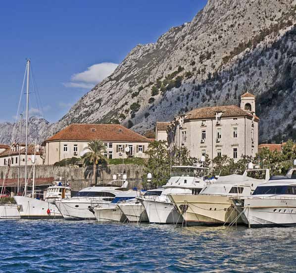
Joint Promotion and Increased Level of Safety of Nautical Tourism
in Dubrovnik-Neretva County and Montenegrin Coast

                                                                                      short-distance cruises (one day long). Due to having keels, their
                                                                                      draught is rather deep. Sailing in a sailboat requires specific
                                                                                      skills and experience, especially if the vessel is not powered
                                                                                      by the engine, but by the sails (wind). When on a sailboat, its
                                                                                      specificities will allow you to gain a feeling of sailing (especially

INTRODUCTION                                                                          when using sails), which takes precedence over luxury. Large
                                                                                      and expensive sailboats are usually chartered with a crew
                                                                                      member – a skipper (you must sail with an experienced
                                                                                      skipper who is familiar with the area, sailing, and the features
Dear navigators, tourists, and lovers of the Adriatic sea, coast,                     of the vessel). Catamarans are a special category of sailboats.
and islands,                                                                          They have two connected hulls. They are comfortable, stable,
You are looking at an informative nautical guide for sailboats                        and spacious, and make sailing easier and more exclusive.
and motor boats originating from the EU – IPA cross-border                            A motor boat is an engine-powered vessel for entertainment,
project “Nautour” and the cooperation of Croatian and                                 sports, or recreation. They are intended for both longer and
Montenegrin institutions (Hydrographic Institute of the                               shorter stay at sea (with cabins, kitchen, lounge, bathroom, etc.).
Republic of Croatia, Institute for Hydrometeorology and                               Their speed and fuel consumption varies (from approximately
Seismology of Montenegro, Montenegro National Tourist                                 7 to 30 knots: semidisplacement vessels, displacement vessels,
Organisation, University of Dubrovnik). This informative                              speedboats). Unlike sailboats, they enable you to visit a
publication covers the seas of the Neretva-Dubrovnik county                           number of locations in a limited timeframe (especially those
and Montenegro, and is intended for those who want to                                 that can go faster than 20 knots). Motor boats are smaller
visit the Neretva-Dubrovnik County and Montenegro area,                               than mega yachts – up to 30 m long. Larger makes (those
especially by boat (sailboat, motor boat or mega yacht). It                           longer than 20 m) are large and spacious, and their features
provides the basic information on the aquatorium, on its                              can be similar to those of mega yachts. Compared to sail
natural beauties and historical and cultural sights, as well as the                   boats, they have shallower draughts, which enables them to
hospitality of the hosts. There is one version of the publication                     enter smaller and shallower coves. They are appropriate for
for sailboats and motor boats, and one for mega yachts.                               almost all coastal areas and ports. Modern motor boats are
A sailboat is a vessel whose main source of power is the                              comfortable, spacious, and equipped with all the necessities.
wind, even though all sailboats have engines and use them if                          Larger motor boats, due to their value, power and demands,
the conditions require so. Sailboats are used for entertainment,                      are chartered with at least one crew member – skipper (you
sports or recreation and a brief or longer stay at the sea (they                      must have an experienced skipper who is familiar with the area
have cabins, a kitchen, a lounge, a bathroom, etc.).                                  and the features of the vessel). On larger motor boats, there is
They reach relatively low speed and therefore have a limited                          a special cabin for the skipper. Smaller motor boats are not as
daily range (sailboats are not as fast as motor boats – their                         comfortable as the large ones, since their main purpose is not
average speed is up to 7 knots) and are therefore favoured for                        staying on them, but transfer from one location to another.

          5            For informative purposes only. This Guide is not intended to be used in navigation
                       and cannot be used instead of official nautical charts and navigation publications.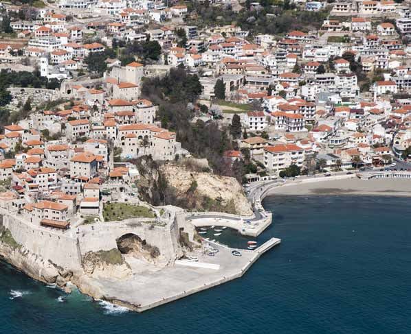
INFO AND
INFO MAP OF THE DUBROVNIK-NERETVA COUNTY MAP  OF
                                            THE                       A
                                                  THE DUBROVNIK-NERETVA
                                                MONTENEGRIN COAST

                               10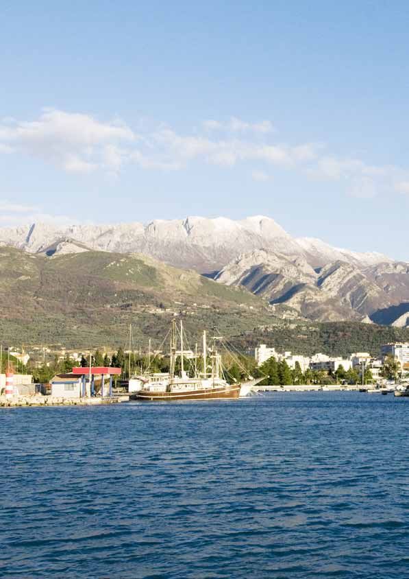
COUNTY
C      AND THE MONTENEGRIN COAST

                             K

                                        SVETI

                                   11
Basic InformaTION
Cross-Border
Programme
Croatia - Montenegro
www.nautour.info
MONTENEGRO
Geographical position: Montenegro lies in the south-west Average temperature: Average annual air temperature on
of the Balkan Peninsula and has coast on the Adriatic Sea – it the coast is 15.7°C, while average summer temperature is
is therefore both a Balkan an Adriatic-Mediterranean country. 23.6°C, and average winter temperature is 8.5°C.
The southernmost point of the country lies at 41º52’ N and Average annual maximum daily temperature on the coast is
18° 26’- 20° 22’ E, closer to the Mediterranean than any other 20.5°C, average maximum temperature in summer is 28.7°C,
southern Slavic country – direct distance from the town of and average maximum temperature in winter on the coast
Bar to the Strait of Otranto is 180 km. The Beograd-Bar railway of Montenegro is 12.8°C.
takes the meridian direction, connecting the Adriatic and Sea temperature: Average annual temperature of the Adriatic
Pannonian basins, i.e. southern and central Europe. Along sea belonging to Montenegro is 17.7°C; average temperature
with the international waters, the coastal sea borders with of the sea in summer is 23.7°C while average sea temperature
Italy, which exerted a significant cultural influence in some in winter season is 12.3°C. In summer months maximum sea
parts of Montenegro in the period of Venetian rule. temperature is up to 27.1°C. Transparency of the sea is 38-56
Surface: The surface of Montenegro is 13,812 km². The total m and duration of bathing season of 180 days.
length of its border is 614 km. It borders with Croatia (14 km) Average number of hours of sunshine: During the year on
and Bosnia and Herzegovina in the west (225 km), Serbia in the the Montenegrin coast there are on average 2,462 hours of
north (128 km), and Albania(172 km) and Kosovo (75km) on sunshine. Of that number 941 hours on average belong to
the east, and between Montenegro and Italy lies the Adriatic summer season, which makes 38% of the annual number of
Sea. The end points of Montenegro are: in the north: 43° 32’N, hours of sunshine. In winter there are 353 hours of sunshine
20° 21’ E – the slopes of the Kovač mountain near the town on average.
of Moćevići; in the south: 41° 52’ N, 19° 22’ E – at the Bojana National parks: Montenegro was the first country to be
river island, at the mouth of the Bojana river; in the east: 42° declared an ecological state (in 1991). There are as many
53’ N, 20° 21’ E – at the Jablanica village, east of Rožaje; in the as five national parks in the small territory of Montenegro:
west: 42° 29’ N, 18° 26’ E – at the Sutorina village, near Herceg Biogradska Gora National Park (5,650 ha), Lake Skadar National
Novi. Territorial sea surface is 2.099 km². Park (40,000 ha), Durmitor National Park (33,400 ha), Lovćen
Population: According to the preliminary results of the 2011 National Park (6,220 ha, representing a perfect symbiosis
census, the population of Montenegro is 625,266. of water areas and wild karst) and Prokletije National Park
Capital: The capital Podgorica is also the largest city in (16,630 ha).
Montenegro, and its administrative and economic centre, Official language and alphabet: The offi cial language
while Cetinje has the status of the royal capital. According to in Montenegro is Montenegrin, and the Cyrillic and Latin
the 2011 census, the population of Podgorica was 156.169. The alphabet are equally used: Serbian, Croatian, Bosnian and
Podgorica municipality comprises 10.4% of the Montenegrin Albanian languages are officially used.
territory and approximately 30% of its population. Podgorica Travel documents: Passport or other internationally
is located in the vicinity of the remains of the ancient Roman recognised documents. Tourists can stay in Montenegro up
town of Doclea and National Park Scadar lake. to three months based on a short stay visa or without visa.
Coast length: The total length of the Montenegrin coast is Citizens of the EU, USA, Russia, Japan and Israel do not need
293 km, of which 73 km are beaches. The longest, 13 km-long visa as well as the countries from the region. For additional
beach, is in Ulcinj. Total number of beaches in Montenegro information contact diplomatic representative offices of
is 117. Montenegro abroad or Consular Department within the
Number of islands, islets, and rocks: 48. Ministry of Foreign Affairs and European Integration (www.
Climate: The vast water surfaces of the Adriatic Sea and Lake mip.gov.me).
Skadar, the bay of Boka Kotorska penetrating deep into the Currency: The currency used in Montenegro is EURO (€),
land, the mountain hinterland near the coast (Orjen, Lovćen, even though Montenegro is not an EU member.
Rumije), and the high mountains of Durmitor, Bjelasica and Credit cards: Visa, Visa Electron, MasterCard, Maestro, American
Prokletije, all have impact on the Montenegrin climate. Express, Diners.
The southern area of the country is dominated by the Time zone: Montenegro is in the Central European time
Mediterranean climate. Mount Orjen is among the locations zone (GMT + 1). On the last Saturday in March, the time zone
with greatest precipitation in Europe. The area receives 4600 switches to GMT + 2, until the last Sunday in October.
mm of precipitation per year; average precipitation at the Mains voltage and water: 220 V, 50 Hz. Tap water is safe for
town Crkvice, on the slopes of the Orjen mountain, is 5000 drinking in the entire country
mm per annum, which is the European maximum, and the International calling code: +382
maximum precipitation in record years reaches 7000 mm/ Official Tourism website of Montenegro: www.montenegro.
m². Central and northern Montenegro are dominated by travel
mountain climate, and the northernmost part of the county Customer Care Center: +382 13 00 Petrovac
by continental climate.
Basic InformaTION
REPUBLIC OF CROATIA
DUBROVNIK-NERETVA COUNTY
Geographical position: Croatia stretches from the foot of °C during summer and 5 to 15 °C during winter. Transparency and
Julian Alps on the north-west to the Pannonian Basin in the East, blueness of the sea exceed those of other seas – the transparency
through the Dinaric massif in central Croatia, to the Adriatic Sea of the Adriatic Sea reaches up to 56 meters. Sea salinity is 38‰,
in the south. The Dubrovnik-Neretva County is the southernmost which exceeds global salinity average. The intensity of sea currents
of the 7 counties on the Adriatic coast. Because of its border with is low; those that run along the eastern – Croatian – coast are
Bosnia and Herzegovina at Neum, the country is divided into two warm, and those along the western Italian coast are cold. The most
parts. The Dubrovnik-Neretva County borders with Bosnia and typical winds in the Adriatic are the bora (NNE to ENE), sirocco (or
Herzegovina on land and at sea. jugo) (ESE to SSE) and mistral (WNW to NW). The Adriatic is rich in
Surface: The surface of Croatia is 89,810 km2, out of which 56,610 flora and fauna, inhabited by numerous species of fish, mammals,
km2 is land (63%), and 33,200 km2 is sea (37%). The Dubrovnik- molluscs, crustaceans, echinoderms, plankton, algae, sponges, and
Neretva County covers 9,272 km2, out of which 1,782 km2 is land other organisms.
(19%), and 7,490 km2 is sea (81%). It covers 3% of Croatia’s land Average number of sunny days per year: With an average
territory and 23% of its territory at sea. of 108 sunny days (2,600 sunny hours) per year, the Croatian side
Population: Croatia has a population of 4,290,612. The average of the Adriatic is one of the sunniest coasts at the Mediterranean.
population density is 78 inhabitants/km2. The Dubrovnik-Neretva National parks and nature parks (natural landscapes): There
County has a population of 122,783 who live in 5 cities (Dubrovnik, are eight national parks and eleven nature parks in Croatia. National
Korčula, Ploče, Metković and Opuzen) and 17 municipalities (Blato, park Mljet (in the western part of the Mljet island) and the nature
Dubrovačko primorje, Janjina, Konavle, Kula Norinska, Lastovo, park of the Lastovo group of islands are located in the Dubrovnik-
Lumbarda, Mljet, Orebić, Pojezerje, Slivno, Smokvica, Ston, Trpanj, Neretva County.
Vela Luka, Zažablje and Župa dubrovačka). Average population Official languages and alphabet: Croatian language and
density is 69 inhabitants/km2. Latin alphabet.
County capital: Zagreb (population: 792,875) Dubrovnik (popu- Travel documents: Passport or other internationally recognised
lation: 42,641). identification documents. Tourists are allowed to remain in Croatia
Total length of coast: The length of Croatian coast is 6,278 km, for up to three months. For more details, contact the Croatian dip-
including islands, islets, rocks, and reefs. The coastal line of the lomatic missions abroad or the Ministry of Foreign and European
Dubrovnik-Neretva County comprises 1025 km. Affairs of the Republic of Croatia (www.mvep.hr).
Number of islands, islets, and rocks: Croatia has 78 islands, 524 Currency: The Croatian currency is the kuna (currency sign: kn,
islets, and 642 rocks and reefs. The numerous and indented islands international currency code: HRK). One kuna is subdivided into
are the reason why the coastline of Croatian islands (70%) is longer 100 lipas (lp).
than the coastline on land (30%). The Dubrovnik-Neretva County Credit cards: The most frequently used credit cards in Croatia are
has a number of open-sea islands and those that are closer to the the following: Eurocard/Mastercard, Visa, American Express, and
coast (the most signifi cant of which are Korčula, Mljet, Lastovo, Diners. These will be accepted in almost all hotels, marinas, restau-
and the Elaphites group), including the lower Neretva area with rants, and stores, at ATMs / cash machines, and in shopping malls.
the pertaining coastal area. Time zone: Croatia is in the Central European time zone (GMT + 1).
Climate: While northern Croatia has a continental climate, central On the last Saturday in March, the time zone switches to GMT + 2,
Croatia has a mountain climate of various intensity levels, and until the last Sunday in October.
southern Croatia has a Mediterranean climate. The Dubrovnik- Mains voltage and water: 220 V, 50 Hz. Tap water is safe for
Neretva area shows all the characteristics of Mediterranean climate drinking in the entire country.
(long and dry summers, mild and rainy winters) with climatic dif- International calling code: International calling code for
ferences as a consequence of the high mountain barrier near the Croatia is +385.
coast, a series of islands, and occasional continental infl uences. The official site of Dubrovnik and Neretva County Tourist
Temperature: Summer temperature varies from 22 to 26 °C in Board: www.visitdubrovnik.hr
continental area, from 15 to 20 °C in the mountains, and from 26 Craotian National Tourist Board: www.croatia.hr
to 35 °C at the coast.
Croatian Adriatic: Adriatic Sea temperature varies from 22 to 25
Šipan port, Island Šipan
9 For informative purposes only. This Guide is not intended to be used in navigation
and cannot be used instead of official nautical charts and navigation publications.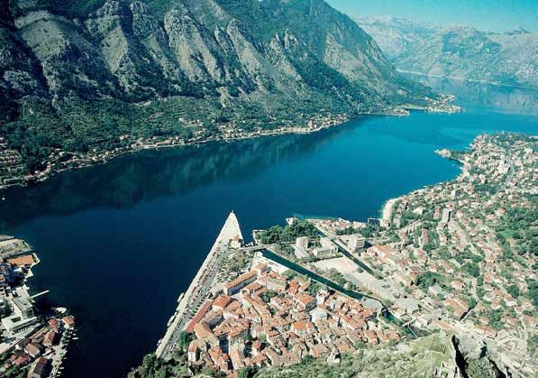
Cross-Border
Programme
Croatia - Montenegro
This Project is funded
Herceg Novi www.nautour.info
by the European Union
MONTENEGRO
BOKA KOTORSKA
This is the largest and most hidden bay in the Adriatic. islets, and sailing through Boka is certainly one of the
As you approach the bay from the open sea, sailing in most impressive and unique experiences you will find
between the two capes at its mouth (the elongated, when sailing in the Mediterranean. One of the results
narrow Cape Oštra in the west and Cape Mirište in the achieved through the activities of partners in the project
east), you will not suspect just how big this bay really is is the establishing of the new depth of the Kotor Bay. It is
and how deeply its meandering mouth penetrates the southwest from the place called Dražin vrt (mark 00001 on
mainland. At first glance, it looks like any other large cove. the map) and the new established depth is 67.96 metres.
It is oriented towards the north and somewhat towards
the north-west (the bay of Herceg Novi), but once you WARNING: The bura wind is strongest in the Bay of
enter that section, you will see the large bay of Tivat in Risan; the usual wind speed that reaches one knot in
the east, in the middle of which is the mouth of a narrow the spring can escalate to up to three knots, especi-
canal leading towards the north (the Verige Pass). This ally in the canals. The speed limit is 12 knots; in the
is a sailing route leading towards the most hidden and narrowest part between the bays of Herceg Novi and
most attractive part of this natural wonder. This part of Tivat, off Port Kumbor, the limit is 8 knots, and you are
the bay is similarly oriented as the first part of the bay not allowed to come closer to the coast than 50 m; the
and comprises two parts – the Bay of Risan in the west maximum allowed speed at Verige Pass is 8 knots. You
and the Bay of Kotor in the east, expanding towards should mind ferries crossing the canal from the towns
the south, with the Port of Kotor. Sailing through Boka of Kamenari and Lepetane (sometimes there will be up
Kotorska is therefore an incredible and exciting series of to three ferries sailing and docking at the same time!).
changes in course and a constant string of discoveries and Shellfish and fish are grown at several locations in the
surprises. There is another equally impressive attraction bay and you should keep a distance from these.
in addition to this natural sea attraction: the two capes
at the mouth of the bay reach coastal heights of 200 m.
In the first part of the bay, the height of the surrounding HERCEG NOVI, Boka bay
mountains is more than twice that height, and at the end
of the bay, they grow into high cliffs like a natural and This is the only town in Boka that you can see from the
awe-inspiring wall. There is also the Boka, surrounded open sea. As the town was being built, it expanded to
by peaks reaching more than 1000 m. Add to this the a large strip along the shore and has merged with the
picturesque historical towns and villages on the coasts surrounding towns, one of which is the town of Igalo
of Boka Bay, with fortifications, towers and defence walls located on the western end of Boka Bay, famous for its
(the first of which are located at the very mouth of the spa. This a very old town that was fought for fiercely
bay, at Cape Oštra and the Mamula Islet off the eastern between all major Mediterranean forces throughout hi-
cape), as well as a number of churches, located even on story (for a short period, the town even fell under Spanish
10 Boka Kotorska
Igalo
administration). This is apparent from some non-historical
information: in popular poetry, there is no town in Boka
that has been mentioned as much as Herceg Novi. The
strategic importance of the town is evident through the
large fortification located east of the port, dominating
the view from the sea. Considering its history, it is no
wonder that the town contains so many historically
significant buildings. One of the most prominent local
sights is the Sahat Tower (clock tower), erected by the
WARNING: Mind the rocks east and south-east from
Turks in the mid-17th century. The town was founded in
the breakwater pier. The rocks are 1.5 cables (cca.
late 14th century by Bosnian King Tvrtko I. He erected a
250m) off the shore. There are waves during times of
fort overseeing the port, with the intention to separate
southern winds.
the town from Dubrovnik, with which he often had fierce
disputes because of the two towns’ efforts to become
Berth sideways in the first part of the breakwater pier
dominant in the salt trade. St Stephen gave the name to
which is usually meant for tourist boats, with the per-
the town. The town’s “new” 15th century ruler, the Duke
mission of the harbour administration. You can anchor
of Hum, also known as “herceg”, changed its name to
west of the port, east of the port, in Meljine Bay, next
Herceg Novi. In the eastern end of Herceg Novi, where
to Zelenika Port, or off Igalo (Topla Bay). The end of
the town has merged with the little town of Meljine, is the
the Bay is shallow!
Savina monastery, the most beautiful Eastern Orthodox
complex in Boka dedicated to Saint Sava. It is a cult place
for Orthodox believers from Boka. NOTE: The beach at Topla Bay in Igalo is ideal for children.
Next to the long breakwater dock in the port is the Accessible for people with disabilities too.
harbour office of Herceg Novi. There is a petrol station
on the fifth dock.
11 For informative purposes only. This Guide is not intended to be used in navigation
and cannot be used instead of official nautical charts and navigation publications. Zelenika
ZELENIKA, Boka Bay
This is the newest town in Boka Kotorska, erected approxi- There is safe anchorage from the bura wind to the west
mately one hundred years ago as the southernmost port of the docks in the port, in Meljne Bay.
reachable by the Austro-Hungarian railroad, connecting
Boka with Vienna and Budapest. You will only berth in the old docks for the purpose of
At the eastern end of the docks, there is a small dry-storage border formalities, but in the case of strong southern and
marina with several berths in the south-western winds or in agreement with the border
sea. authorities in Zelenika, the necessary permits can be
obtained and other cross-border obligations can also be
lenika met in Herceg Novi, Tivat or Kotor when entering and
Port of Ze
leaving the area (especially in the case of large yachts).
There is a maritime border crossing and a Kotor harbour
branch office, police and customs and marina . Zelenika
is also harbour for transport ship traffic.
WARNING: The sea will swell significantly in the Port
during winds blowing from the south-west and south.
Boka bay
n
avigatio
not for n
not for navigation Tivat, Porto Montenegro
TIVAT, Boka Bay request of the Yugoslavian government, it was returned
and became part of the Yugoslavian Navy Training Ship
Tivat developed at the end of a wide plateau (flatlands are Squadron and was renovated at the Tivat shipyard. Until
rare in the mountainous area of Boka, which is why the 1991, it was permanently berthed in Lora, the Yugoslavian
airport is located here) and it is one of the newest towns Navy harbour in Split, and later in Tivat. After Montenegro
in the bay. Tivat was the location of choice for noblemen became independent, it was renovated, and took part in
from Prčanj, Dobrota and Kotor and this is where they international boat exhibitions in Portugal and England,
built their summer residences, along with famous and as part of the Montenegrin Navy.
wealthy sailors (the most famous summer villa is the South of Tivat, off the eastern part of this area of Boka,
one belonging to the Buća-Luković family). They were three islands divide the bay into two parts. The first of
also responsible for the construction of the city park, the them – Prevlaka Island – is an island only in high tide and
largest one in Boka, full of exotic plants brought back by a peninsula in low tide. There you will find the ruins of a
seafarers from their journeys. monastery Sv Arahangel Michael dating from the early
The town owes its development to the Austro-Hungarian 13th century and a Trinity church from the 19th century.
monarchy that decided to build its naval base there as Next is Stradioti Island (Sv. Marko), the largest island in all
well as the Arsenal shipyard, once more underling the of Boka, and the third is the convent island – the island
great strategic importance of Boka throughout history. of the Mother of God or Our Lady of Mercy. There is also
The shipyard also continued its development and pur- a Jesuit monastery and a 15th century church.
pose in the former Yugoslavia, until Montenegro became The Porto Montenegro Marina is a maritime point of
an independent country, when it was decided that the entry. There is also a petrol station.
shipyard would become the Porto Montenegro Marina,
to the benefit of all sailors. This is the largest marina for WARNING: To the west of the far-western cape of Stradioti
large yachts in the eastern part of the Adriatic and was Island is a shallow area that stretches for half a mile, at the
a positive development for the town in many ways (the end of which is a sign and a light; the eastern end of the Bay
marina itself and many of its amenities on the mainland of Tivat (Podpolje Bay) is shallow with shellfish farms, so you
are still being developed). cannot anchor there; runway lights of Tivat Airport are located
With this new marina, you no longer need to look for at the end of the Bay; the Bay is also well-protected from bura
space at the large docks east of the marina (Staničić winds, and open to westerly winds.
Docks) where the Jadran school boat is permanently
Berth in the eastern side of the marina and in the western
berthed and where other tourist boats also berth. The
basin of the inner part of the Porto Montenegro marina.
magnificent three-masted tall ship Jadran was built in 1931
There is a limited possibility to berth on the docks for
in Hamburg, Germany, for the needs of the Yugoslavian
passenger and tourist boats to the east of the Marina
navy. Until World War II, the ship was used for training
(Staničić Docks).
students at the Dubrovnik Navy Academy; then it sailed
Anchor approximately 7 cables from the eastern end of
under the Italian flag, and following the defeat of Italy it
the Tivat bay (Podpolje entry).
almost went to ruin berthed in Venice. After the war, at theCross-Border
Programme
Croatia - Montenegro
This Project is funded
www.nautour.info
by the European Union
Kotor
KOTOR, Boka Bay administration buildings all contribute to this wonder
of urbanism that has a special charm. A stroll down the
The strategic importance of Boka Kotorska throughout streets of Kotor is an experience which will remain deeply
its history is apparent from the monumental appearance ingrained in your memory. The old town’s core is one of
of the town, which still radiates with dignity, significance the best-preserved towns in the Mediterranean and is
and power. For centuries, Kotor was the farthest point under UNESCO protection. The maritime heritage of Kotor
of the Turkish territory. The perfectly preserved walls of is one of the most significant in the Adriatic. The tradition
Kotor are some five kilometres long and are a unique of seafarers, captains and seamen whose sailboats sailed
example of fortification architecture in Europe. Since the the Mediterranean date back to early Middle Ages. That
town was founded in the 7th century, the walls have been is when the notion of the Boka navy – an association
changed and upgraded. They bear the marks of many of Kotor and Boka captains and seafarers – originates
different ages. For example, the St Ivan fort (also known from. The purpose of its establishment was to connect
as San Giovanni) is one of the most important Venetian individuals and social classes, to combine their interests,
forts that they had in the Adriatic. and increase the level of social safety and protection
Churches, the palaces of Kotor patricians and public (the traditions of the association are still kept today).
14Joint Promotion and Increased Level of Safety of Nautical Tourism
in Dubrovnik-Neretva County and Montenegrin Coast
The heyday of maritime navigation was in the 17th and PERAST, Boka Bay
18th centuries, when there were more than 300 sailboats
registered in Kotor. Kotor’s maritime activity led to the Perast, baroque town of Boka Bay once had great strategic
advancement of the entire bay, especially the towns in importance because it was the best place from which
its vicinity. At one particular moment in history, there to control the narrow Verige Pass on the way to the
were around one hundred transoceanic shipmasters northern, most hidden part of the Bay of Boka Kotorska
in Prčanj, who were so rich that they even lent money (in the heyday of Boka towns, there were chains on the
to the state during the Venetian administration. It is no eastern and western shores to close off the pass). For
wonder then that the parish church of the Nativity of that reason the St Cross fortress was built, a defensive
Mary, one of the most monumental sacral edifices in fort that dominates over the city, erected before the
the region, dominates the panorama of Prčanj. Ivo Visin, Battle of Lepanto. This stone town, which looks like time
the first seafarer from one of the South Slavic nations to stopped in it during the age of sailing boats, is one of the
sail around the world in his small sailing boat Splendido, best-preserved city cores on the eastern Adriatic shore.
was also born in Prčanj. In the 17th century a maritime college was established
Kotor was home to a beatified person, the blessed Ozana in the town. The college was so famous that even the
of Kotor. This modest shepherd from Montenegro became Russian emperor Peter the Great sent young noblemens
known for her clairvoyance abilities and fulfilment of there. Perast is also famous for its bell-towers – this town
prophecies. She played an essential role when Turkish is constructed on a slope next to the sea and has as many
Admiral and pirate Hajrudin Barbarossa attacked Kotor. as 22 churches and family chappels. The Bujović family
The glass sarcophagus with her relic is located in St Mary’s palace, located in the west of the town, is considered to be
of the River co-cathedral. one of the most beautiful palaces in the entire Boka area.
The port has a harbour office, maritime border crossing To the west of the town are two of Boka’s sacral archi-
and harbour administration, police and customs. tecture wonders – the islands with the church of Our
Lady of the Rocks and St George’s Church. Our Lady of
WARNING: The port is well-protected from wind, apart the Rocks was built on an artificial islet and the church
from the western winds that cause waves. The bura is incredibly attractive and harmonious in appearance. It
wind is strong, but it does not create waves. During was built by layering rocks where an icon of Our Lady was
low tide, the north-western currents are strong next found on a stormy night. The icon was one of the icons
to the docks and the shore; to the north of the docks, from the house of the Moršetić brothers and its discovery
the inflow of the Škurda River creates a current that is considered to be associated with the recovery of the
can become strong after rainfall. health of one of the brothers. Today this is beautifully
The first part of long triangle-shaped docks is for cruise painted church with arround 2000 votive plates. The
ships, and the remaining berths are reserved for mega construction of the church started in 1452. St. George’s
yachts. Berths have water and electricity connections. Island was once the seat of the Benedictine abbey, and
The Harbour Administration of Kotor decides on the the church and monastery were first mentioned back in
place of berthing. the 12th century. They have been reconstructed many
times since then. The legend of a tragic love from Perast
Perast
15 For informative purposes only. This Guide is not intended to be used in navigation
and cannot be used instead of official nautical charts and navigation publications.Cross-Border
Programme
Croatia - Montenegro
This Project is funded
www.nautour.info
by the European Union
Gospa od Škrpjela
inspired Swiss painter Arlond Beklin for the paint “Island beautiful as a fairy, wiser than a snake, and braver than
of deads”. a lion. She had a man’s heart in a female body. After she
inherited the throne, she moved to Risan and erected a
WARNING: The bura wind here blows from the Bay of Risan fort on Gradina Hill overlooking the sea, and the remains
towards the Verige Pass and is not so strong at the docks. of the fort are still visible. When the Romans besieged the
Sirocco and maestral winds that blow from the Verige Pass town, Teuta and her people, with their treasures, hid in the
do not create large waves. fort and resisted the Roman forces for months. When she
The main docks in Perast are located under the church saw that the enemy was about to conquer the fort, legend
bell tower. These docks, just like the two smaller docks has it that Teuta threw herself and her treasure down the
to the west and east of this one, are full of boats, most of waterfall of an underground river, which eventually flows
them transporting passengers to Our Lady of the Rocks into Mount Orjen. She left behind the legend of a great
(there is a small dock on the island too). In the summer, treasure that archaeologists are still looking for today.
you can only find a place to berth on the ‘main’ dock in (There is another legend about Teuta and her castle,
the evening, when those boats stop sailing to the island. which is related to the islet of Svetac off Vis).
You can anchor in front of the little town; during bura The Romans fortified the town named Risinium and tur-
winds, anchor closer to the eastern end of the town, and ned it into their most important base in all of Boka. They
in sirocco, anchor at the beginning of the Bay of Risan. also had a mint here. The remains of a Roman villa with a
well-preserved mosaic showing Hypnos, the god of sleep
(the only showing of Hypnos on the East of Adriatic sea),
have also been found from the end of second century.
RISAN, Boka Bay The old, mostly abandoned town of Risan is a cluster of
small stone houses around a small street, rising from the
Risan was an important Illyrian foothold and military sea up the hill. It looks surreal, almost like a movie set. The
navy port. It was the reigning capital of Queen Teuta. old town centre is invisible because it is now surrounded
The Romans defeated the Illyrians in the 3rd century B. by new buildings. Today Risan is a quiet and somewhat
C. According to legend, Teuta, the Illyrian queen, jumped shabby-looking town. As you sail near it, the hotel on the
into the sea from the tall cliffs overlooking Risan. It does north of the town and the, waterfalls from cave Sopot,
not take much imagination to see how rich the town must special hospital for orthopaedics and neurosurgery will
have been if it had a mint back in 230 B.C. This means dominate the view. In nearby Lipci there are deer drawings
that sea and land trade were significantly developed. dating from the Iron Age.
Teuta was a pirate queen, the terror of the south Adriatic
and the Strait of Otranto. According to Roman sources, WARNING: Strong bura winds blow in the port, but there
following the death of her husband, King Argon, Queen are no waves. There are waves when the wind blows
Teuta continued to conquer Greek colonies, and Greek from the west.
cities asked Rome to help them turn away the pirate
queen. When fighting with the Romans in 229 B.C., the The docks closing the small port and the shore are full
Illyrians lost large territories and peace was established a of boats belonging to locals. The docks are a closed-off
year later. There is no reliable data concerning the destiny customs port for smaller trading ships. You can anchor
of Queen Teuta, which has given rise to the legend that safely in front of the town.
still survives today. According to legend, Teuta was as
Risan
16Cross-Border
This Project is funded
Programme
Croatia - Montenegro
by the European Union www.nautour.info
ŽANJICE, cove TRAŠTE, cove
This is a nice cove on the western part of the Luštica This vast cove is oriented in a south-east – north-west
Peninsula, at the very entrance to the Bay of Boka Ko- direction, stretching out for three miles. The narrowest
torska. Only a small rounded peninsula separates it from part of the Luštica Peninsula separates the Bay from the
the somewhat smaller cove of Mirište (to the south of Bay of Boka Kotorska, i.e. the bay of Tivat, which is only
Žanjica cove), all of them creating a harmonious whole. three kilometres away.
Both bays are ideal for taking a first swim in the ‘open’ sea Depending on the wind, you can find good shelter in
after you leave Boka Kotorska, i.e. the last swim before Trašte, which branches out into several arms. The Međeđa
you enter the bay. At the end of the Žanjica cove, you and Oblatna coves are located in the western part of the
will encounter a 300 m beach, giving you an idea about Bay. There is an abandoned quarry in Međeđa, while there
the dozens of similar beaches lining the shore towards are docks for loading stone next to Cape Kamenova (the
the south-east. This beautiful beach attracts numerous southern cape of that arm). Immediately to the north, in
visitors and bathers. There are dozens of holiday houses Oblatna Cove, is a vast sandy beach with a large summer
lining the slopes rising above the beach, and a short jetty villa offering activities for tourists. There are several buoys
on the southern shore. anchored in front of the beach. In the northernmost arm,
One of the attractions of this bay is its fortified monastery in narrow Pržna Cove, a top-category Mediterranean-style
with the church of the Initiation of Our Lady (the construc- hotel is being constructed (there used to be an old hotel
tion of the church began in the 15th century) which takes at this location). The end of the cove is covered in sand,
up almost the entire surface of the miniature islet of Gospa and there is a protective floating fence in front of the
to the north of Cape Mirište. The islet Lastavica, known as beach. The shores of the cove are rocky.
Mamula (named after an Austrian military commander), The safest shelter is deep towards the south-east, in the
faces the coves. This impressive fort guarded the entrance Bigova arm, which penetrates deep inland.
into the bay, together with the tower on Cape Oštra (the
western entrance into Boka Kotorska Bay). There is no WARNING: There is a shallow strip in front of Cape Trašte in the
end to the numerous attractions on this narrow strip of eastern part of the Bay (there is a lighthouse at the cove). The
sea. Not far from here is another wonder of nature – the Kalafat rocks are marked 1.8 miles to the south-east of Trašte
Blue Cave. Around a mile and a half to the south-east of cove. In the north-western arm of the Bay, you will find good
Cape Mirište, in the rocks between Zlatna Port and Mala protection from maestral winds, but the sea is shallow next
Gora bays, is a wonderful cave, the ceiling of which rises to the shore of this arm. The Pržna arm is completely exposed
nine metres above the sea. to southern and south-western winds. In the summer, there
is a protective floating fence. Bigova Cove is protected from
WARNING: Žanjica cove is protected from southern bura and southern and south-western winds. The end of the
winds, but there are swells during strong winds. The Bay is shallow.
Bay is completely open to winds from the west and
south-west. The end of the Bay is shallow, and there Depending on the wind, you can anchor in front of the
is a floating protective fence in front of it. When you north-western shore of the bay, in front of the Međeđa
anchor, mind a tear at the depth of approximately 30 m, and Oblatna coves, of in front of the south-eastern arm
400v m to the west off Cape Ogada (between Žanjica of the bay (Bigova cove).
and Mirište coves).
Anchor in the middle of Žanjica cove of in front of the
less protected Bay of Mirište.
NOTE: The beach at Žanjica cove is ideal for children
17 For informative purposes only. This Guide is not intended to be used in navigation
and cannot be used instead of official nautical charts and navigation publications.This Project is funded Cross-Border
Programme
Bigova by the European Union
Croatia - Montenegro
www.nautour.info
BUDVA
BIGOVA, cove
Budva is the tourist mecca of Montenegro, a town everyo-
This is a nice cove in the far south-eastern part of Trašte ne wants to visit and stay in. Just like Korčula, Budva is
cove. Its shallow end deeply penetrates the land and ends located on a peninsula (a long time ago it might have
in fertile cultivated land. You can find medicinal mud at been an island). Because of its harmony, tightly packed
the end of the Bay. Bigova used to be the most famous houses with church towers, public buildings and narrow
fishing town in the area and some of this ambience is streets, the old part of Budva is irresistibly attractive.
still there, but the appearance of the Cove changed quite Budva is an old town, one of the oldest in the Adriatic.
dramatically with the development of numerous holiday According to legend, the founder of Budva was Cadmus
houses. This Cove is the best-protected part of Trašte Bay. (the son of Phoenician king Agenor) who embarked on a
search for his sister Europa. He travelled in an ox-driven
WARNING: The Cove is protected from all northern winds, carriage (the Greek word buthoe, bus means “ox” and
and even from north-western winds. The end of the Bay gave the name to the town) and conquered the Illyrian
is very shallow. lands. In the 5th century B.C. there was a market in the
town area where local Illyrian people exchanged goods
You can berth on the old stone breakwater dock, with with the Greeks. A diocese was founded here as early as
a double concrete addition on the north-western side, in Byzantine times. Since the location of the town is of
so the berth is separated by a breakwater wall. (There strategic significance, its history has been very eventful. All
is a harbour light in the old part of the docks.) You can the powers in the eastern Adriatic ruled the town at one
anchor anywhere in the Cove. point or another – the Romans, Slavic, Venetians, French
and Austrians. Logically, due to the constant danger of
conquest, the town was surrounded by a wall with four
doors, just like Kotor – two towards the sea (Murava
and Porta Pizana), one facing east, and one towards the
land. As the southernmost Venetian possession, Budva
was often attacked by pirates. On several occasions, they
managed to penetrate the walls and pillage the town.
Since the area behind Budva used to be closed, it was a
refuge for many refugees who sailed from all sides. This
was a kind of quarantine for those who waited to sail
BudvaJoint Promotion and Increased Level of Safety of Nautical Tourism
in Dubrovnik-Neretva County and Montenegrin Coast
further from Budva.
The old town pulsates with vibrancy. Everything is open
until late in the night – stores, cafes, restaurants, museum
and even churches. This is also true of the modern part
of the town which stretches towards the north and east,
along the shore of the bay. Unfortunately, the modern
part of the town is less aesthetically pleasing than the
old town, and construction has not waned during the
past decade. You can berth safely in the marina in front of the northern
The port, which was turned into a marina, has a harbour’s waterfront of the port; the waterfront in the most pro-
office, marina Budva office maritime border crossing, tected part of the port is intended for mega yachts. You
police station, customs, petrol station and nautical can anchor on both sides of the reef between the Sveti
equipment shop. Nikola islet and the shore (east of the port), in Jaz Cove,
immediately to the west from port of Budva (there is
WARNING: Approach the port from the south throu- a wide, 1.2 km long pebble beach), in Trsteno Cove
gh an excavated pass marked with lights west of the (immediately to the west of Jaz Cove), or off the beach
elongated, tall island of Sveti Nikola. There are several in Bećići (east of the port).
rocks in front of the west coast of this island, in addition
NOTE: The 17 pebble/sand beaches in Budva and its
to reefs and shallow areas, so you should keep away
surrounding area are ideal for children.
from its shore (the most dangerous reef is Galijola, to
the west of Cape Školj, the southern far point of Sveti
Nikola Island). There is a narrow reef strip between the
northern cape of the island, stretching northwards, all BEČIĆI
the way to the coast; it is therefore not advisable to enter
the port from the eastern side (there is a 5 m deep pass A large port which is actually the eastern part of the vast
closer to the shore). Between the north-western cape of Budva bay and is ‘physically’ separated from the port of
Sveti Nikola Island and the port, there is an underwater Budva by the steep rocky Zavala Cape. Because of this
reef marked with a buoy and light at its shallowest point monumental cape, people also call the bay Zavala. Bečići
(4.9 m). Bura winds make entry significantly difficult. has grown from a small village into the most popular
The port is protected from western winds, and the tide destination on the Budva Riviera. The almost 2 kilometre
rises when there are southern winds blowing. long pebble beach has always been attractive to touri-
sts and is rightfully considered to be one of the most
beautiful beaches in Montenegro. At the tourist expo in
Paris in 1935, the beach was proclaimed to be the most
beautiful European beach.
The cove is ideal for anchoring and taking a break from
sailing or before docking in the Budva marina.
WARNING: The western part of the bay is sheltered from all
winds, apart from southern winds.
Anchor further away from the beach to avoid swimmers.
The waters in the western, most protected, part of the
bay, off Cape Zavala, are meant for water scooters and
water skiers.
NOTE: Ideal for swimming for children.
19You can also read