Tahmoor South Coal Project - Preliminary Issues Report: State Significant Development (SSD 8445) - Mining News
←
→
Page content transcription
If your browser does not render page correctly, please read the page content below
Tahmoor
South Coal
    Project
          Preliminary Issues Report:
          State Significant
          Development
          (SSD 8445)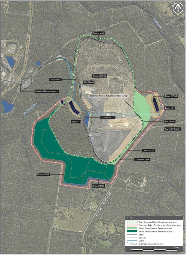
June 2019

© Crown Copyright, State of NSW through its Department of Planning and Environment 2019

Disclaimer

While every reasonable effort has been made to ensure this document is correct at time of printing, the State of
NSW, its agents and employees, disclaim any and all liability to any person in respect of anything or the
consequences of anything done or omitted to be done in reliance or upon the whole or any part of this document.

Copyright notice

In keeping with the NSW Government’s commitment to encourage the availability of information, you are
welcome to reproduce the material that appears in this report. This material is licensed under the Creative
Commons Attribution 4.0 International (CC BY 4.0). You are required to comply with the terms of CC BY 4.0 and
the requirements of the Department of Planning and Environment. More information can be found at:
http://www.planning.nsw.gov.au/Copyright-and-Disclaimer.

Tahmoor South Coal Project (SSD 8445) | Preliminary Issues Report                                            i
Glossary
 Abbreviation               Definition

 CCL                        Consolidated Coal Lease

 CEEC                       Critically Endangered Ecological Community
 CHPP                       Coal Handling and Preparation Plant
 CIV                        Capital Investment Value
 Commission                 Independent Planning Commission of NSW
 Consent                    Development Consent
 Council                    Wollondilly Shire Council
 Department                 Department of Planning and Environment

 DoEE                       Department of Environment and Energy
 DoI                        Department of Industries
 EIS                        Environmental Impact Statement
 EPA                        Environment Protection Authority
 EP&A Act                   Environmental Planning and Assessment Act 1979
 EP&A Regulation            Environmental Planning and Assessment Regulation 2000
 EPBC Act                   Environment Protection and Biodiversity Conservation Act 1999
 EPI                        Environmental Planning Instrument
 EPL                        Environment Protection Licence
 ESD                        Ecologically Sustainable Development

 IESC                       Independent Expert Scientific Committee
 LEA                        Local effects analysis
 LEP                        Local Environmental Plan

 LGA                        Local Government Area
 Minister                   Minister for Planning

 ML                         Mining Lease
 MNES                       Matters of National Environmental Significance
 NPV                        Net present value
 OEH                        Office of Environment and Heritage

 Project                    Tahmoor South Coal Project
 REA                        Rejects Emplacement Area
 RMS                        Roads and Maritime Services

 ROM                        Run-of-mine
 RTS                        Response to Submissions

 SA NSW                     Subsidence Advisory NSW

Tahmoor South Coal Project (SSD 8445) | Preliminary Issues Report                           ii
SEARs                      Secretary’s Environmental Assessment Requirements
 SEPP                       State Environmental Planning Policy

 SIA                        Social Impact Assessment
 SRD SEPP                   State Environmental Planning Policy (State and Regional Development) 2011
 SSD                        State Significant Development

Tahmoor South Coal Project (SSD 8445) | Preliminary Issues Report                                       iii
Executive Summary
Tahmoor Coal Pty Ltd (Tahmoor Coal), a subsidiary of SIMEC (Australia) Mining Pty Ltd owns the Tahmoor Coal
Mine, located between the towns of Tahmoor and Bargo approximately 75 kilometres south-west of Sydney and
within the Wollondilly and Wingecarribee local government areas.

Tahmoor Coal Mine has several existing development consents for underground mining granted by either the
local council or the Minister for Planning and has been operating in some form since the 1970s.

The approved project – known as the Tahmoor Coal Project (the Approved Project) involves extraction of coal until
2022, at a rate of up to 3 million tonnes of run-of-mine coal a year (Mtpa). Coal is approved to be transported by
rail to Port Kembla Coal Terminal, or occasionally Newcastle Port Waratah, for delivery to both Australian and
International markets. Tahmoor Coal Mine also has approval to transport up to 50,000 tonnes per annum of coal
by road within the Wollondilly Shire or in circumstances where rail transport is unavailable.

Tahmoor Coal is now proposing to expand the Approved Project to the south with an application known as the
Tahmoor South Coal Project (the Project). The Project would extract up to 4 Mtpa of run-of-mine coal and process
this to produce up to 3 Mtpa of product coal. Existing mine facilities would continue to be utilised for an additional
13 years (ie until 2035). Coal would continue to be primarily transported by rail to the two coastal shipping
terminals. The key change to the existing operation involves an extension to the size and height of the existing
rejects emplacement area and construction of an additional two ventilation shafts.

The proposal is classified as a ‘State Significant Development’ under Part 4 of the Environmental Planning and
Assessment Act 1979 (EP&A Act), as it is development for the purpose of coal mining and mining-related works.
The Minister for Planning and Public Spaces is the consent authority for the application. However, under the
Minister’s delegation dated 11 October 2017, the Executive Director, Resource Assessments and Compliance may
determine the application as there were less than 25 objections to the Project, neither Council objected to the
Project and Tahmoor Coal has not made reportable political donations.

The Project has a capital investment value of approximately $342.5 million (undiscounted) and would generate
employment of up to 422 full time operational jobs (approximately 390 full time operational jobs would continue
from the Approved Project) and up to 150 temporary construction jobs at the mine. It is also predicted to generate
$700 million in (net present value) economic benefits to NSW.

Engagement
The Department of Planning and Environment (the Department) exhibited the Environmental Impact Statement for
the Project from 23 January to 5 March 2019 (42 days).

The Department received 86 public submissions: 8 from special interest groups and 78 from the general public.
73 (85 %) public submissions were in support of the Project, citing mainly its employment and economic benefits.
11 (13 %) public submissions objected to the Project, with key issues including subsidence and related property
damage, groundwater impacts (especially regarding Thirlmere Lakes), climate change and biodiversity impacts.

The Department also received advice from 12 government authorities. None of the Government authorities
objected to the Project, although most raised issues and/or made recommendations relevant to their respective
statutory responsibilities.

Tahmoor South Coal Project (SSD 8445) | Preliminary Issues Report                                                  iv

The Department and the Commonwealth Department of the Environment and Energy jointly requested the
Commonwealth Independent Expert Scientific Committee on Coal Seam Gas and Large Mining Development to
provide advice on the Project.

The Department has also engaged Hugh Middlemis of Hydrogeologic, an independent groundwater expert, to
review key groundwater aspects of the Project.

Key Issues
On 15 January 2019, the then Minister for Planning requested the Independent Planning Commission of NSW (the
Commission) conduct an initial public hearing into the Project, as soon as practicable after the public exhibition
period. The Minister asked that the Commission consider the EIS, submissions and any relevant expert advice and
other information, and prepare a report that (amongst other things) identifies the key issues requiring detailed
consideration by the Department in evaluating the merits of the Project.

The Department has undertaken a preliminary review of the development application, EIS and submissions and
considered the agency and expert advice received. Key issues from this preliminary review include:

•   subsidence – including its impacts on homes and other built features and on groundwater and surface water
    resources;
•   water resources – including further clarification and details of the groundwater modelling, groundwater
    sensitivity assessment, exchange between surface water and groundwater, and the management of impacts to
    groundwater bore users;
•   amenity impacts – including application of current noise policy and technical inputs;
•   biodiversity impacts – including clearing of a critically endangered ecological community and other threatened
    species, further clarification on biodiversity offset availability and consideration of other reject emplacement
    methods;
•   social impacts – including impacts on the owners of subsidence affected properties, the local Aboriginal
    community and people with a connection to Thirlmere Lakes; and
•   economic – including assumptions used to calculate employment benefits and the Project’s local
    environmental, social and transport impacts.

The Department notes that there is a range of additional concerns raised in public submissions, along with strong
support for the Project from the majority of submitters, identifying the positive social, employment and economic
benefits of mining to the broader regional economy.

Assessment
Following the initial public hearing by the Commission, the Department will undertake a comprehensive
assessment of the merits of the Project in accordance with the requirements of the EP&A Act and relevant NSW
Government policy and guidelines and the matters raised in meetings, hearings and the submissions identified
above.

The Department will continue to undertake targeted consultation with landowners and key stakeholders prior to
finalising its detailed assessment report.

The Department will also undertake an assessment of the Project’s impacts on Matters of National Environmental
Significance on behalf of the Commonwealth, in accordance with the Assessment Bilateral Agreement between
the Commonwealth and NSW Governments.

The Department’s groundwater expert and Government agencies will also continue to provide advice to the
Department during assessment of the Project. This will include review of any additional information provided by

Tahmoor South Coal Project (SSD 8445) | Preliminary Issues Report                                                v
Tahmoor Coal on issues raised by the experts and, where relevant, advice on any findings and recommendations of the Commission following its public hearing. NSW Government agencies have an important role in the assessment process due to their subsequent regulatory oversight roles if the Project is approved. The Environment Protection Authority (EPA) regulates noise, air emissions and water pollution through an Environment Protection Licence (EPL). The Department of Industry regulates water take through Water Sharing Plan rules and the provisions of the Water Management Act 2000. The NSW Resources Regulator and the Department’s Division of Resources and Geoscience have roles in ensuring rehabilitation objectives are met under the provisions of the Mining Act 1992. Some of these are key areas of concern to the community and the Department will continue to work closely with Government agencies during assessment of the Project. An important consideration in assessment of the Project is that the impacts of the Approved Project have already been assessed and an approval granted, with the development consents imposing conditions to manage, mitigate and offset these impacts. The Approved Project will not be reassessed, but the impacts of the extension Project will be considered in detail, including cumulative impacts. Tahmoor Coal proposes to surrender Tahmoor Coal Mine’s existing development consents over time, if the Project is approved. This means that, in the long-term, the mine would be regulated under a single consolidated and contemporary development consent, if the current application is approved. Once the Department has completed its assessment, the Project may be referred to the Commission by the Minister for Planning and Public Spaces for further public hearings prior to final determination of the development application. Tahmoor South Coal Project (SSD 8445) | Preliminary Issues Report vi
Contents
Glossary ............................................................................................................................. ii

Executive Summary ............................................................................................................. iv

     Engagement .................................................................................................................................... iv
     Key Issues ......................................................................................................................................... v

     Assessment ....................................................................................................................................... v

1.      Background .................................................................................................................. 1
     1.1        Ownership History ................................................................................................................. 1

     1.2        Approvals History................................................................................................................... 1

     1.3        Current Operations ............................................................................................................... 3
     1.4        SIMEC ................................................................................................................................. 3

2.      Project Details .............................................................................................................. 3

3.      Strategic Context .......................................................................................................... 9

     3.1        Southern Coalfield ................................................................................................................ 9

     3.2        Coal Resource ...................................................................................................................... 9

     3.3        Thirlmere Lakes Inquiry .......................................................................................................... 10

     3.4        Water Resources .................................................................................................................. 10

     3.5        Land use .............................................................................................................................. 11

     3.6        A Plan for Growing Sydney .................................................................................................... 12

     3.7        Western District Plan ............................................................................................................. 12

4.      Statutory Context ........................................................................................................ 13

     4.1        State Significant Development ............................................................................................... 13
     4.2        Permissibility ....................................................................................................................... 13

     4.3        Objects of the Act ................................................................................................................ 13

     4.4        Environmental Planning Instruments ........................................................................................ 14
     4.5        Integrated and Other NSW Approvals..................................................................................... 14

     4.6        Gateway Assessment ............................................................................................................ 15

     4.7        Commonwealth Approvals .................................................................................................... 15
     4.8        NSW Independent Planning Commission ................................................................................ 16

5.      Engagement ............................................................................................................... 16

     5.1        Department’s Engagement.................................................................................................... 16
     5.2        Submissions ........................................................................................................................ 17

Tahmoor South Coal Project (SSD 8445) | Preliminary Issues Report                                                                                       vii
5.3 Key Issues – Government Agencies ......................................................................................... 18
5.4 Key Issues – Councils ............................................................................................................ 20
5.5 Key Issues – Community and Special Interest Groups ................................................................ 21
5.6 Independent Expert Scientific Committee Advice ..................................................................... 21
6. Preliminary Issues Review ............................................................................................ 22
6.1 Subsidence and Geomorphology ..........................................................................................22
6.2 Water Resources .................................................................................................................. 28
6.3 Amenity and Health Impacts .................................................................................................. 43
6.4 Biodiversity ......................................................................................................................... 47
6.5 Social ................................................................................................................................. 49
6.6 Economics .......................................................................................................................... 50
6.7 Other Issues ........................................................................................................................ 52
7. Conclusion ................................................................................................................. 54
Appendices ...................................................................................................................... 56
Appendix A – Environmental Impact Statement ....................................................................................56
Appendix B – Agency Advice and Public Submissions ...........................................................................56
Appendix C – Submissions summary ................................................................................................... 57
Appendix D – IESC Advice ................................................................................................................ 65
Appendix E – Expert Peer Review ....................................................................................................... 65
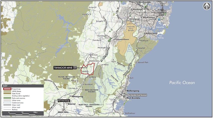
Tahmoor South Coal Project (SSD 8445) | Preliminary Issues Report viii1. Background
Tahmoor Coal Pty Ltd (Tahmoor Coal), a subsidiary of SIMEC (Australia) Mining Pty Ltd (SIMEC) owns the Tahmoor
Coal Mine, located between the towns of Tahmoor and Bargo, approximately 75 kilometres south-west of Sydney
within the Wollondilly and Wingecarribee local government areas (LGAs) (see Figure 1).
1.1 Ownership History
Tahmoor Coal Mine has been operating since the 1970s under various owners and operators. The mine was
originally constructed by Clutha Development in 1975 with bord and pillar mining commencing in 1980 and the
Tahmoor Washery being commissioned in 1981.
In 1985, BP Coal acquired the mine and commissioned a gas extraction facility in 1987. It was at this time that
longwall mining commenced. BP Coal sold its interest to Conzinc Rio Tinto Australia in 1989, which owned the
site until 1997 when it sold to Austral Coal Ltd, with Centennial Coal Pty Ltd then acquiring a majority share in
Austral Coal Ltd in 2005.
In 2007, Xstrata Coal Pty Ltd acquired 100% shareholding in Austral Coal Ltd and with it, the ownership of Tahmoor
Coal. In May 2013, Xstrata Coal Pty Ltd and Glencore Coal Pty Ltd (Glencore) merged. On 20 April 2018, SIMEC
purchased Tahmoor Coal from Glencore and became the current owner and operator of Tahmoor Coal Mine.
1.2 Approvals History
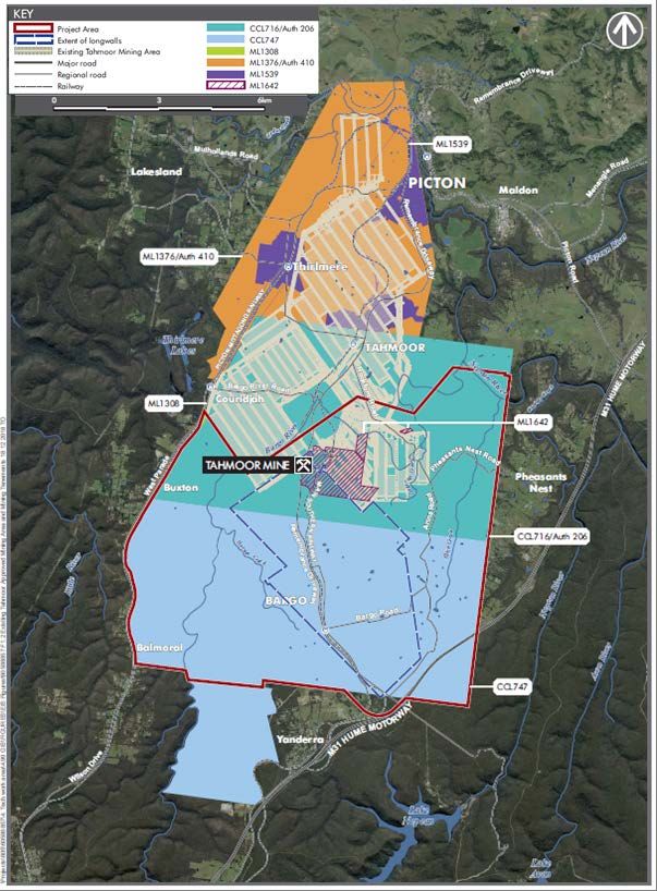
Tahmoor Coal Mine consists of two Colliery Holdings under the Mining Act 1992 (Mining Act), including the
Tahmoor Colliery Holding (Consolidated Coal Lease (CCL) 716 and Mining Leases (MLs) 1308, 1376, 1539 and
1642; and the Bargo Colliery Holding (CCL 747). The Department notes that limited development was undertaken
at Bargo Colliery between 1979 and 1981 before being discontinued in June 1981.
Tahmoor Coal Mine is divided into three distinct mining areas, including:
• Tahmoor Central – Longwalls 1 – 21;
• Tahmoor North – Longwalls 22 – 37; and
• Tahmoor South – the proposed Tahmoor South Coal Project (the Project).
The Tahmoor Coal Mine currently operates under several development consents, the earliest of which dates back
to 1975, with the key consents shown in Table 1 below.
Table 1 | Tahmoor Coal Mine development consents
Consent Consent Authority Permits
Wollondilly Shire Allows underground mining in the central area of the Tahmoor Coal Mine
DA 1975
Council in 1975
Land and Environment Allows underground mining in the Tahmoor North area, excluding certain areas
DA 57/93
Court in 1994 below urban land and rail infrastructure where mining was, at that time,
prohibited under the applicable environmental planning instruments
Minister for Planning Allows underground mining in parts of the areas excluded under DA 57/98.
DA 67/98, as
modified in 1999 Mining in these areas had become permissible by this time, and the application
sought to subside those parts of the excluded areas where subsidence was
predicted in the mine plan
Tahmoor South Coal Project | Preliminary Issues Report 1Figure 1 | Regional Context Tahmoor South Coal Project | Preliminary Issues Report 2
1.3          Current Operations
Tahmoor Coal Mine targets the Bulli Coal Seam, although several lower coal-bearing units occur in the area,
including the Balgownie Coal Seam and Wongawilli Coal Seam.

These other seams are major sources of carbon dioxide and methane in the existing mine. Consequently, these
seams are drilled and degassed for safety reasons. Some of the methane produced via this mine gas drainage is
used for electricity generation by Energy Developments Ltd, with the remainder being flared.

On-site facilities and infrastructure at Tahmoor Coal Mine includes a Coal Handling and Preparation Plant (CHPP)
which can process up to 650 tonnes of coal per hour, ventilation shafts, gas drainage and a rail load-out facility and
rail loop.

Product coal is approved to be transported by rail to Port Kembla Coal Terminal, or occasionally Newcastle Port
Waratah, for delivery to both Australian and International markets. Tahmoor Coal Mine also has approval to
transport up to 50,000 tonnes per annum (tpa) of coal by road within the Wollondilly Shire or in circumstances
where rail transport is unavailable. Tahmoor Coal currently employs up to 390 ongoing permanent and contract
staff. The approved operational areas at Tahmoor Coal Mine are shown in Figure 2.

1.4          SIMEC
SIMEC is a subsidiary of GFG Alliance, an international group of businesses founded and owned by the British
Gupta family. GFG Alliance’s main operating businesses include:

•   Liberty House Group, which has five main divisions, comprising commodities, recycling, steel (including
    primary steel at Whyalla), aluminium and engineering; and
•   SIMEC Group, which also has five main divisions, comprising shipping, infrastructure, mining, energy and
    commodities.
Tahmoor Coal is an operating business within the SIMEC Mining division of the GFG Alliance. Approximately 25%
of metallurgical coal produced at Tahmoor Coal Mine is sold to domestic steelmakers (ie GFG Whyalla and
Bluescope Port Kembla). If the Project is approved, it is expected that the proportion of product coal sold to GFG
Whyalla would increase to approximately 40% domestic sales.

                    2. Project Details
Tahmoor Coal is proposing an extension of the mining and ancillary activities associated with its existing mine. The
key elements of the Project are:

•   extracting and processing an additional 48 million tonnes (Mt) of run-of-mine (ROM) coal by extending the
    footprint of the underground mine to the south of the approved footprint towards and beneath the town of
    Bargo;
•   increasing the maximum extraction rate of ROM coal from 3 Mt per annum (Mtpa) to 4 Mtpa;
•   extending the life of the mine by approximately 13 years until 2035;
•   constructing and operating two additional mine ventilation shafts;
•   horizontal and vertical expansion of the existing coal rejects emplacement area (REA); and
•   upgrades to the mine’s existing surface facilities, amenities, equipment and infrastructure, including the car
    park.

Tahmoor South Coal Project | Preliminary Issues Report                                                              3
Figure 2 | Project Area and the Tahmoor Central and Tahmoor North Mining Areas Tahmoor South Coal Project | Preliminary Issues Report 4
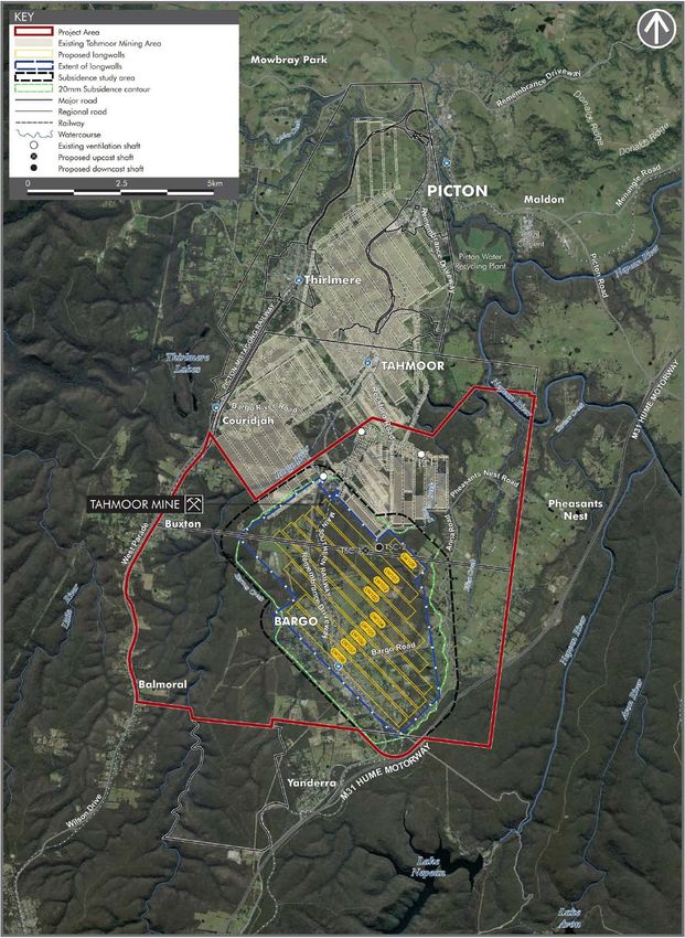
The proposed Project is detailed further in Table 2 and depicted in Figure 3, with the expanded REA shown in
Figure 4. Approved activities are also included for comparison purposes. The proposal is described in detail in
the Environmental Impact Statement (EIS) for the Project (see Appendix A).

Table 2 | Main components of the Project

 Project               Existing Tahmoor Mine                            Tahmoor South Coal Project
 Component

                       • Up to 3 Mtpa                                   • Peak production rate of up to 4 Mtpa
 ROM Coal
 Production Rate
                       • Anticipated to be completed by 2022            • Additional 13 years life, until approximately 2035
 Project Life
                       • To date, the mine has extracted                • Longwall extraction of approximately 47.4 million
 Mining and
 Reserves                  approximately 51 Mt of ROM coal from           tonnes of ROM coal from the Bulli Seam, providing
                           Longwalls 1 to 31 in the Bulli Seam,           around 38 Mt of product coal
                           providing around 38 Mt of product coal
                       • Approximately 12 Mt of ROM coal is yet
                           to be extracted, which is expected to
                           provide around 9 Mt of product coal

                       • On-site stockpiling and processing of 3        • On-site stockpiling and processing of 4 Mtpa of ROM
 Processing
                           Mtpa of ROM coal from the mine                 coal from the mine
                       • Production of up to 2 Mtpa of product          • Production of up to 3 Mtpa of product coal from the
                           coal from the CHPP                             CHPP

                       • Up to 2 Mtpa of product coal is                • Up to 3 Mtpa of product coal to be transported by rail
 Coal Transport
                           transported by rail to Port Kembla or          to Port Kembla or occasionally to Newcastle
                           occasionally to Newcastle                    • The Project would also utilise the road network to
                       • Up to 50,000 tonnes of product coal              transport and/or receive product coal and reject
                           transported by road within Wollondilly         material where rail transport is unavailable or imported
                           LGA                                            coal is needed for special blends, or where a market
                       • Road transport of product coal allowed           opportunity for beneficial use of rejects exists.
                           when rail transport is unavailable           • Road transport would be restricted to a maximum of
                       • Up to 50,000 tonnes of reject material           200,000 tpa and a maximum of 3,000 tonnes per day
                           to be transported by road                    • Road transport campaign periods generate a maximum
                                                                          of eight truck movements per hour during the period
                                                                          between 6 am to 7 pm

                       • The existing REA covers approximately          • Production of approximately 9.5 Mt of rejects
 Rejects
 Management                89 hectares (ha) and has a capacity of       • REA would increase by approximately 43 ha and
                           approximately 13 Mt (approximately 4           capacity would increase by 12 Mt to 25 Mt
                           Mt capacity remaining)                       • The maximum height of the REA would increase by 5 m
                       • The maximum height of the REA is 13              to 18 m above ground level in its southern section
                           metres (m) above ground level

                                                                        • Constructionof an upgraded intersection at
 Roadworks             •    Not applicable
                                                                          Remembrance Driveway / Tahmoor Mine Access Road

                       • Up to 390 ongoing permanent and                • Up to 175 construction workers
 Employment
                           contract staff                               • Up to 440 operational workers

                                                                        • Approximately an additional $342 million
 Capital Value         •    Various     depending        on     which
                            development consent is taken into
                            account

Tahmoor South Coal Project | Preliminary Issues Report                                                                         5
Project Existing Tahmoor Mine Tahmoor South Coal Project
Component
• Mining operations, train loading and • Mining operations, train loading and rail transport 24
Hours of
Operation rail transport 24 hours a day, seven days hours a day, seven days a week
a week • REA proposed to operate 7am to 10pm, 7 days a week
• REA operates 24 hours a day, Monday • Road transport of product coal or rejects is proposed to
to Friday only occur between 6 am and 7 pm, on up to seven
days a week
• Construction to be undertaken 6 am to 7 pm, seven
days a week, with the exception of ventilation shaft
construction, which would occur 24 hours a day, 7 days
a week
• Progressive rehabilitation of REA and • Progressive rehabilitation of REA and surface
Rehabilitation
surface disturbance areas, disturbance areas, predominantly to native bushland
predominantly to native bushland
• A total of 50 ha has been rehabilitated
to date
• The REA has an area of 89 ha: • Clearance of an additional 49.2 ha of native woodland
Disturbance
Area, Vegetation – 35 ha are disturbed and to allow for expanded REA, construction of two
Clearing and operational; ventilation shafts and extension of car park
Biodiversity
Offsets – 4 ha are internal dams; and • Offset the following biodiversity impacts, in
– 50 ha have been rehabilitated accordance with the Framework for Biodiversity
• No biodiversity offsets are required for
Assessment:
the existing REA
– clearance of 43.4 ha of Shale Sandstone Transition
Forest Critically Endangered Ecological
Community (CEEC);
– clearance of 5.7 ha of Upper Georges River
Sandstone Woodland;
– removal of 2,324 Grevillea parviflora subsp.
parviflora plants;
– removal of 100 Persoonia bargoensis plants;
– removal of 7.4 ha of potential habitat for Large-
footed Myotis;
– removal of 43.5 ha of potential habitat for Koala.
The Department notes that the Project comprises a single mining domain referred to as the Central Domain. Two
additional domains, the Eastern and Southern Domains, were previously identified by Glencore as mineable
however are not included as part of SIMEC’s Project due to the presence of geological features (eg major faults)
and a greater number of risk management zones and sensitive features.
The coal resource to be targeted is of high quality and would be processed to produce both coking coal for use
in the steel making industry, and thermal coal for use in power generation. Approximately 91 per cent of the
saleable product coal would be coking coal, and 9 per cent would be thermal coal.
If development consent for the Project is granted, existing consents would be surrendered (in some cases, after
mining is completed in 2022) and elements of the existing consents (eg activities related to surface facilities) would
be governed only by the new development consent. Surrendering existing consents would enable a smooth
transition to a single consent to govern activities, final closure and rehabilitation at Tahmoor Coal Mine as a whole.
Tahmoor South Coal Project | Preliminary Issues Report 6Figure 3 | Proposed Tahmoor South Project Area Tahmoor South Coal Project | Preliminary Issues Report 7
Figure 4 | Proposed Reject Emplacement Extension Area

Tahmoor South Coal Project | Preliminary Issues Report                                     8
3. Strategic Context
3.1        Southern Coalfield
The Southern Coalfield is renowned for its premium quality, hard coking coals, used predominantly for steel
manufacture. This coalfield is the principal source of hard coking coal within the State and supports both the Port
Kembla and Whyalla Steelworks and provides significant coking coal exports.

All mining in the Southern Coalfield is undertaken using underground methods, principally longwall mining.
Longwall mining is the most economic method of underground mining and has the greatest recovery of coal.
However, it inevitably results in subsidence of surface features.

The Southern Coalfield is unique in NSW, in that much of it is located beneath high-value native vegetation and
streams primarily used as water catchment. The water catchment is divided between the Special Areas (close to
dams and stored waters) and the outer catchment (other areas within the broader catchment). The Special Areas
allow careful management by WaterNSW of the catchments of the Avon, Cordeaux, Cataract, Woronora and
Nepean Dams, which supply water to the greater Wollongong area and (in the case of Woronora) to southern
Sydney.

There are only two active mines in the Special Areas – Dendrobium Coal Mine and Metropolitan Coal Mine. There
are four other active mines in the broader catchment (Springvale Colliery, Clarence Colliery, Bulli Seam Operations
(including Appin, Appin West and Westcliff Collieries) and Tahmoor Coal Mine). Springvale Colliery and Clarence
Colliery are not within the Southern Coalfield.

Other Southern Coalfield mines include Russell Vale Colliery, Wongawilli Colliery and Berrima Colliery, all of which
are currently under care and maintenance. The closest nearby mine to Tahmoor Coal Mine is Bulli Seam
Operations, located approximately 20 km to the east of the Project.

Most coal produced in the Southern Coalfield is exported or else shipped to Whyalla from the Port Kembla Coal
Terminal. Coal is transported to the Port Kembla Coal Terminal predominantly by rail (60 per cent), either along
the Illawarra South Coast rail line or via the Moss Vale to Unanderra Line.

The Main Southern Railway is a passenger and freight service connecting Sydney with Melbourne which runs
through Tahmoor. Coal can be transported towards Port Kembla from Tahmoor Coal Mine along the Main
Southern Railway, before changing to the Moss Vale to Unanderra Line at the Moss Vale Junction.

The Port Kembla Coal Terminal is the major coal intermodal facility in NSW for the transfer of coal from both road
and rail to ship. It has a total capacity of 18 Mtpa (with around 7.5 Mtpa current spare capacity) and can receive up
to 16 trains of product coal per day.

3.2        Coal Resource
The primary coal-bearing stratigraphic unit in the Southern Coalfield is the Illawarra Coal Measures, with its most
significant resources being the Bulli, Wongawilli, Tongarra and Balgownie Coal Seams. In financial year 2018, raw
coal production in the Southern Coalfield totalled 10 million tonnes and supported the direct employment of
2,450 people.

Tahmoor South Coal Project | Preliminary Issues Report                                                             9
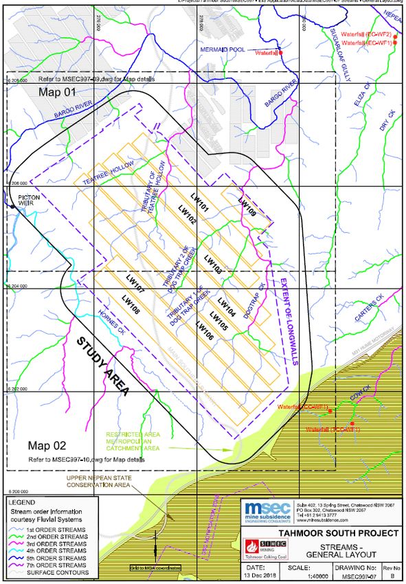
Un-mined resources of prime coking coal are primarily in the Bulli and Balgownie Coal Seams under the Camden-
Campbelltown-Picton region; however, this is a rapidly growing metropolitan area of Sydney, and subject to
strategic land release and other Government policies which limit opportunities for coal resource development.

The Bulli Coal Seam is generally considered to contain prime quality coking coal with medium to high ash and low
to medium volatiles, with an average raw coal production rate of 76%. The Project would target the Bulli Coal
Seam, which reaches depths of up to 800 m in the central north of the Southern Coalfield and exceeds 850 m in
the north-west. The Bulli Coal Seam is 5 m at its thickest in the north of the Coalfield, and in other regions varies in
thickness between 2 and 3 m.

3.3        Thirlmere Lakes Inquiry
The Thirlmere Lakes are a protected wetland system consisting of five lakes (Lake Gandagarra, Lake Werri Berri,
Lake Couridjah, Lake Baraba and Lake Nerringong) that form the basis of the Thirlmere Lakes National Park. The
lakes are located approximately 3.5 km north-west of the Project’s nearest proposed longwall.

Water levels in the Thirlmere Lakes have been falling since 1992. However, the cause(s) of these falls are not
straightforward, with some members of the community suggesting that the drying was related to longwall coal
mining that had taken place to the east of the lakes, principally between 1995 and 2004.

In 2011, the NSW Government commissioned an inquiry into the possible causes of the water level decline, the
Thirlmere Lakes Inquiry. The Inquiry found that there was no evidence of direct impact from mining on the lakes
and that changes in lake levels could be accounted for by drought, heavy rains and some groundwater loss. Further
research into the lake hydrology and groundwater was recommended.

An Independent Committee was established as part of the Inquiry. This committee provided recommendations
for further research, consideration of a ‘groundwater mound’ to minimise groundwater loss and nomination of
Thirlmere Lakes National Park for listing under the Ramsar Convention on Wetlands.

Following these recommendations, a surface water level and rainfall monitoring program was established and an
inter-agency committee of scientists is developing a research program into the causes of changes to water levels
in the lakes. This work led to a report which highlighted several knowledge gaps and catalogued areas for further
research. In October 2017, the Office of Environment and Heritage (OEH) announced a $1.9 million research
program, the Thirlmere Lakes Research Program, which would run over four years and help address these
knowledge gaps.

3.4        Water Resources
The Project is adjacent to the Sydney Drinking Water Catchment, with drinking water catchments which supply
Lake Nepean, Lake Avon, Lake Cordeaux and Lake Cataract located to the east. Lake Nepean is the closest water
storage, located approximately 3 km from the closest longwall. These reservoirs are located within the
Metropolitan Special Area, where general public entry is prohibited. The Project is downstream of these
catchments and the Special Area, and no proposed longwall panels extend into the Special Area.

Tributaries of the Bargo and Nepean rivers traverse the Project area. The Project area is predominantly drained by
Tea Tree Hollow and Dog Trap Creeks, which flow north and east toward the Bargo River. To the south-west of the
proposed longwall panels, Hornes Creek also flows into the Bargo River. The east of the Project area is
predominantly drained by Eliza Creek, which flows northward toward the Nepean River. A small part of the eastern
portion of the Project is also drained by Carters Creek, which flows north-eastward to the Nepean River. Cow
Creek lies within the Metropolitan Special Area and flows into the Nepean River, which is to the east of the Project
area.

Tahmoor South Coal Project | Preliminary Issues Report                                                               10
The Project area is covered by the Greater Metropolitan Groundwater Sources Water Sharing Plan. There are a
large number of privately-owned groundwater extraction bores within and surrounding the Project area (ie 791
within the groundwater model area which covers 3,237 km²).

In December 2006, the NSW Government established an independent inquiry into underground coal mining in
the Southern Coalfield. This Inquiry was established because of concerns held in both Government and the
community over previous and potential impacts of subsidence covered by underground mining operations on
natural surface features.

The terms of reference required the panel conducting the Inquiry to focus its review on subsidence-related impacts
on rivers, significant streams, swamps and cliff lines. In July 2008, the Southern Coalfield Inquiry released a report
titled Independent Strategic Review of Impacts of Underground Coal Mining on Natural Features in the Southern
Coalfield. The Inquiry concluded that valley closure and upsidence effects from underground mining cause the
majority of impacts on significant natural surface features, such as cracking of stream beds, rock falls from cliff lines
and alteration of groundwater chemistry in shallow aquifers.

The Inquiry made a total of 22 recommendations regarding best practice assessment, impact minimisation,
management, monitoring and remediation of subsidence impacts. The EIS has considered the Inquiry’s
recommendations in its assessment of subsidence impacts, including the development of risk management zones.

A review of the findings of the 2008 Inquiry is currently underway by a new Independent Expert Panel for Mining
in the Catchment (the Panel) which has been established by the Government and tasked with providing informed
expert advice to the Department on the impact of mining activities in the Greater Sydney Water Catchment Special
Areas, with a particular focus on risks to the quantity of water in the Catchment.

Under its Terms of Reference, the Panel is focused on the Special Areas of the catchment. As the Project is located
outside the Special Areas, it falls outside the Terms of Reference for the Panel.

3.5        Land use
Land use in the region is characterised by a mix of land uses, including village residential, rural residential,
agriculture, vacant Crown land and conservation areas. The area predominantly exhibits gently undulating slopes;
however, the topography becomes steeper near the Bargo and Nepean river valleys, north and west of the Project,
respectively. These steeper areas are also more densely forested.

Nearby conservation areas include the Upper Nepean State Conservation Area (SCA), the Bargo River SCA, Nattai
National Park, Thirlmere Lakes National Park and Blue Mountains National Park. The three national parks form part
of the Greater Blue Mountains UNESCO World Heritage Area.

The Upper Nepean SCA is the largest of the SCAs surrounding the Project. It was established in 2007 and covers
a total area of 25,869 ha. Approximately 171 ha of this area (2%) lies within the Project Area although the proposed
development itself does not extend into the SCA. The closest national park is Thirlmere Lakes National Park,
located approximately 2.47 km from the closest longwall panel.

Rural residences, villages and towns surround the mine. The nearest towns are Tahmoor and Bargo and the nearest
villages are Couridjah, Balmoral, Yanderra and Buxton. The Project would mine directly beneath the town of Bargo,
including direct undermining of approximately 750 houses. There are also approximately a further 750 houses
located within the subsidence affectation zone (ie subsidence associated with the Project may affect approximately
1,500 houses to some extent).

The Project is located within the Bargo Mine Subsidence District. A district is a land zoning tool administered by
Subsidence Advisory NSW (SA NSW) under the Coal Mine Subsidence Compensation Act 2017 to help protect
homes and other structures from potential mine subsidence damage.

Tahmoor South Coal Project | Preliminary Issues Report                                                                11
Districts are proclaimed in areas where there are potential subsidence risks from underground coal mining that has
occurred or may take place in the future. SA NSW regulates building and subdivision works within districts to
ensure new homes and structures are built to an appropriate standard that reduces the risk of damage should
subsidence occur.

The Coal Mine Subsidence Compensation Act 2017 also provides for the assessment and management of risks
associated with subsidence resulting from coal mining operations and includes provision for compensation or
repairs required to mitigate the damage caused by mine subsidence.

The owners of buildings or other surface improvements damaged by mine subsidence can lodge claims for
compensation through SA NSW. SA NSW supports property owners throughout the assessment process and
facilitates compensation or repair by mine operators where damage results from active mining operations.

The Project would also extend beneath semi-rural and partly forested landscapes in a region with a long history of
agricultural use, including poultry, cattle grazing, trotting horse training, greyhound training and horse studs.
Large-scale vegetation clearance has occurred on these flat or moderately sloped agricultural areas. Nevertheless,
areas of good quality remnant and rehabilitated vegetation also exist within the Project area, particularly to the
north-east.

Key infrastructure assets in the area include the:

•   Main Southern Railway, which extends north-south through the Project area and supports passenger and
    freight services between Sydney and Melbourne;
•   M31 Hume Highway, to the east;
•   Sydney to Moomba gas pipeline;
•   Gorodok Ethane pipeline; and
•   various other utility infrastructure, including water pipelines and transmission lines.

Land in the Project area is owned by either the Crown, various Government authorities, private owners or Tahmoor
Coal. The majority of land is privately-owned, with Crown land and Tahmoor Coal owned land to the north-east
and north-west of the Project area.

3.6        A Plan for Growing Sydney
A Plan for Growing Sydney (NSW Government 2014) aims to promote the growth of Sydney by guiding land use
planning decision making for the next 20 years. The plan provides a framework based around four key goals
including developing a competitive economy, delivering greater housing choice, creating communities and
safeguarding the natural environment.

The Project is considered to be broadly consistent with these goals as it would:

•   enable ongoing direct employment;
•   provide a significant resource-based economic contribution at regional, State and national levels;
•   provide jobs closer to homes in south-western Sydney; and
•   not conflict with future strategic land use in the Bargo area (ie the Metropolitan Rural Area under the plan).
3.7        Western District Plan
The Western District Plan (Greater Sydney Commission 2018) acknowledges that the Western District is
undergoing the most dramatic change of all districts in Greater Sydney. At the same time, it recognises that there
are significant mineral resources in the Western District and that primary industries are essential to the area’s

Tahmoor South Coal Project | Preliminary Issues Report                                                               12
economy. It notes that areas with significant resources may need to be protected to avoid transition to higher uses
such as suburban residential development.
4. Statutory Context
4.1 State Significant Development
The Project is classified as State significant development (SSD) under Division 4.7 of the Environmental Planning
and Assessment Act 1979 (EP&A Act) as it is development for the purpose of coal mining and mining related works,
which are specified in clause 5 of Schedule 1 to State Environmental Planning Policy (State and Regional
Development) 2011 (the SRD SEPP).
The Minister for Planning is the consent authority for the development. However, under the Minister’s delegation
of 11 October 2017, the Executive Director, Resource Assessments and Compliance, may determine the
development application as neither Wollondilly Shire Council nor Wingecarribee Shire Council objected, there
were less than 25 objections from the general public and a political donations disclosure statement has not been
made.
4.2 Permissibility
The Project area is located within the Wollondilly and Wingecarribee LGAs. Actual development would be located
within the Wollondilly LGA only, on land subject to the Wollondilly Local Environmental Plan 2011 (Wollondilly
LEP).
The surface facilities area and REA are on land zoned RU2 Rural Landscape, while the proposed extraction area
extends beneath land zoned primarily E2 Environmental Conservation, E4 Environmental Living, RU1 Primary
Production, RU2 Rural Landscape and RU4 Rural Small Holdings. The footprint of the mine plan also includes areas
of Low and Medium Density and Large Lot Residential (R2, R3 and R5, respectively) and SP2 Infrastructure (Road
and Railway).
Under the Wollondilly LEP the Project is permissible with consent in some land zones and prohibited in other
zones. However, particular provisions of the State Environmental Planning Policy (Mining, Petroleum Production
and Extractive Industries) 2007 (the Mining SEPP) ensure that the Project is fully permissible with consent. Under
this provision, development for the purposes of underground mining is permissible anywhere in the State.
4.3 Objects of the Act
The consent authority must consider the objects of the EP&A Act when making decisions under the Act. The
Department has considered the Project against the current objects of the EP&A Act (see section 1.3 of the Act).
The objects of most relevance to the decision on whether or not to approve the Project are:
• Object 1.3(a): to promote the social and economic welfare of the community and a better environment by the
proper management, development and conservation of the State’s natural and other resources;
• Object 1.3(b): to facilitate ecologically sustainable development by integrating relevant economic,
environmental and social considerations in decision-making about environmental planning and assessment;
• Object 1.3(c): to promote the orderly and economic use and development of land;
• Object 1.3(e): to protect the environment, including the conservation of threatened and other species of native
animals and plants, ecological communities and their habitats;
Tahmoor South Coal Project | Preliminary Issues Report 13• Object 1.3(f): to promote the sustainable management of built and cultural heritage (including Aboriginal
cultural heritage); and
• Object 1.3(j): to provide increased opportunity for community participation in environmental planning and
assessment.
The Department has formed a preliminary view that the Project could permit the continued proper management
and development of a regionally significant coal resource (Objects 1.3(a) and (i)). The Department also considers
that the Project could represent an orderly and economic use of land (Object 1.3(c)). These will be further
considered in the Department’s detailed assessment.
The Department will consider the principles of ecologically sustainable development (ESD, Object 1.3(b)) in its
assessment of the Project and whether it is able to be carried out in a manner that is consistent with the principles
of ESD. The Department’s assessment will seek to integrate all significant environmental, social and economic
considerations.
Consideration of the protection of the environment and heritage (Objects 1.3(e) and(f)) will also be further
considered and assessed as part of the Department’s detailed assessment of the Project.
The Department exhibited the development application and accompanying EIS and also made them publicly
available (Object 1.3(j)).
4.4 Environmental Planning Instruments
Under Section 4.15 of the EP&A Act the consent authority is required to consider, amongst other things, the
provisions of relevant environmental planning instruments (EPIs), including any exhibited draft EPIs, development
control plans (DCPs) 1 or planning agreements.
The EIS includes consideration of several relevant instruments, including:
• State Environmental Planning Policy (SEPP) No.33 – Hazardous and Offensive Development;
• SEPP No.44 – Koala Habitat Protection;
• SEPP No.55 – Remediation of Land;
• SEPP (Sydney Drinking Water Catchment) 2011;
• Mining SEPP;
• Sydney Regional Environmental Plan No.20 – Hawkesbury-Nepean River (No 2-1997);
• Wollondilly LEP 2011; and
• Wingecarribee LEP 2010.
Tahmoor Coal’s assessment concludes that the Project is able to be undertaken in a manner that is generally
consistent with these instruments. The Department has also considered the SRD SEPP and SEPP (Infrastructure)
2007. The Department has formed a preliminary view that the Project is generally consistent with the aims and
objectives of the relevant EPIs. Nevertheless, the Department will further consider these instruments as part of its
detailed assessment of the Project.
4.5 Integrated and Other NSW Approvals
Under Section 4.41 of the EP&A Act, several approvals are integrated into the SSD assessment process and
consequently are not required to be separately obtained for the proposal. These include:
1 SEPP (State and Regional Development) 2011 provides that DCPs do not apply to State Significant Development
Tahmoor South Coal Project | Preliminary Issues Report 14• various approvals relating to heritage required under the National Parks and Wildlife Act 1974 and the Heritage
Act 1977; and
• certain water approvals under the Water Management Act 2000.
Under Section 4.42 of the EP&A Act, several other approvals are required, but must be substantially consistent
with any development consent granted for the Project. These include:
• a mining lease under the Mining Act; and
• an Environment Protection Licence (EPL) under the Protection of the Environment Operations Act 1997.
Tahmoor Coal would also require other approvals for the Project which are not integrated into the SSD assessment
process, including:
• approval under the Coal Mine Subsidence Compensation Act 2017;
• approval under the Crown Lands Act 1989 for any works on Crown land;
• approvals under the Roads Act 1993;
• notification under the Work Health and Safety (Mines) Act 2013 for high risk activities, including emplacement
of reject materials; and
• water licences under the Water Act 1912 and/or the Water Management Act 2000.
4.6 Gateway Assessment
Under Clause 50A of the EP&A Regulation, mining and petroleum related development on strategic agricultural
land is required to undergo a ‘Gateway’ assessment prior to submission of a development application. The
Gateway assessment is an independent, upfront scientific assessment of the impact of applicable mining and coal
seam gas proposals on strategic agricultural land and its associated water resources.
Strategic agricultural land includes:
• Biophysical strategic agricultural land (BSAL) – land that has the best quality soil and water resources and is
capable of sustaining high levels of productivity; and
• Critical Industry Cluster (CIC) land – a concentration of significant agricultural industries potentially impacted
by coal seam gas or mining development.
As part of the Project, additional mining leases would be required to accommodate a proposed expansion of the
existing REA and additional ventilation shafts. On 5 February 2018, the Department issued a Site Verification
Certificate (SVC) confirming that the area is not located on BSAL or CIC land. On 23 October 2018, the
Department issued a further SVC covering 35 ha of land that was not incorporated in the original SVC application.
Consequently, a Gateway Certificate is not required for the Project.
4.7 Commonwealth Approvals
Tahmoor Coal also needs to obtain an approval from the Commonwealth Minister for the Environment under the
Environment Protection and Biodiversity Conservation Act 1999 (EPBC Act), because the Project is a ‘controlled
action’ under the EPBC Act due to its potential impacts on listed threatened species and communities (sections 18
and 18A of the EPBC Act) and a water resource (sections 24D and 24E of that Act).
The assessment process under the EP&A Act has been accredited under the bilateral agreement between the
NSW and Commonwealth Governments. This means that the NSW Government is undertaking the assessment on
behalf of the Commonwealth and must assess all identified matters of national environmental significance (MNES).
Tahmoor South Coal Project | Preliminary Issues Report 15Nevertheless, it is important to recognise that the Commonwealth Minister maintains an independent approval
role for the Project and is expected to undertake this determination following the NSW determination.
4.8 NSW Independent Planning Commission
On 15 January 2019, the Minister for Planning requested the Independent Planning Commission of NSW (the
Commission) to conduct an initial public hearing into the Project, as soon as practicable after public exhibition of
its EIS.
The Minister asked that the Commission consider the EIS, submissions on the Project, and any relevant expert
advice and other information. The Minister also asked that the Commission publish a report on the hearing findings
including, amongst other things, identification of the key issues requiring detailed consideration by the
Department in evaluating the merits of the Project.
Following receipt of the Commission’s Issues Report, the Department will complete its detailed assessment of the
Project. The development application may be referred back to the Commission for final review before the
Department makes its determination.
The Commission may hold further public hearings if directed by the Minister for Planning and Public Spaces, in
accordance with its Guidelines for a Public Hearing Held in Multiple Stages.
5. Engagement
5.1 Department’s Engagement
The Department publicly exhibited the EIS from 23 January 2019 until 5 March 2019 (42 days) and advertised the
exhibition in the:
• Sydney Morning Herald;
• Daily Telegraph;
• The Australian;
• Southern Highland News;
• Macarthur Chronicle; and
• Wollondilly Advertiser.
The EIS was made available at the:
• Wollondilly Shire Council office and Wollondilly Library in Picton;
• Wingecarribee Shire Council office in Moss Vale; and
• Bowral Central Library in Bowral.
The Department also notified Wollondilly Shire Council and Wingecarribee Shire Council and relevant
Government agencies.
Following exhibition on 2 April 2019, the Department met with Department of Primary Industries – Water
(including Natural Resources Access Regulator (NRAR)), Tahmoor Coal and its consultants and the Department’s
independent groundwater expert to discuss issues regarding groundwater modelling and potential impacts (see
Sections 5.3 and 6.2).
Tahmoor South Coal Project | Preliminary Issues Report 16You can also read