Sinter-forming springs and geysers of the Waikato region - Waikato Regional Council Technical Report 2020/04
←
→
Page content transcription
If your browser does not render page correctly, please read the page content below
Waikato Regional Council Technical Report 2020/04

Sinter-forming springs and
geysers of the Waikato region

www.waikatoregion.govt.nz
ISSN 2230-4355 (Print)
ISSN 2230-4363 (Online)
Prepared by:
Ashley D. Cody 1
Ron F. Keam2
Jesse Lebe4
Bridget Lynne3
Katherine Luketina4

1
 Geothermal and Geological Consultant
ashley.cody@internode.on.net

2
Late of Physics Dept, The UNIVERSITY OF AUCKLAND

3
11 Kyle Rd, Albany, AUCKLAND 0632

4
Waikato Regional Council

For:
Waikato Regional Council
Private Bag 3038
Waikato Mail Centre
HAMILTON 3240

July 2021

Document #: 15980020
Peer reviewed by:
 Jim McLeod                                             Date         30 June 2020

 Approved for release by:
 Tracey May                                             Date         29 June 2021

Disclaimer
This technical report has been prepared for the use of Waikato Regional Council as a reference document
and as such does not constitute Council’s policy.

Council requests that if excerpts or inferences are drawn from this document for further use by individuals
or organisations, due care should be taken to ensure that the appropriate context has been preserved,
and is accurately reflected and referenced in any subsequent spoken or written communication.

While Waikato Regional Council has exercised all reasonable skill and care in controlling the contents of
this report, Council accepts no liability in contract, tort or otherwise, for any loss, damage, injury or
expense (whether direct, indirect or consequential) arising out of the provision of this information or its
use by you or any other party.

Doc # 15980020
Doc # 15980020
Acknowledgement
This report is the work of several people over many years. David Speirs of Waikato Regional
Council first commissioned it from Council’s geothermal monitoring contractor Ashley Cody, and
then it grew with the addition of photographs, more accurate map coordinates, spring numbers
in various numbering systems, and recent commentary updates by subsequent observers. All
the contributors have provided valuable enhancements.

We extend our many thanks to the land owners and occupiers who have allowed us access to
the geothermal features on their land, and who act as kaitiaki and look after the features on a
day-to-day basis. Thanks are also due to the many people in the geothermal community who
have undertaken useful research and observation over many years in related topics, and those
who have provided comments on the contents of this report.

There have been unavoidable delays in bringing this report to print, but now that it has been
published, Waikato Regional Council staff hope that it will provide a useful statistical summary
of the region’s rarest and most vulnerable, and most highly prized, geothermal surface features.

Doc 15980020                                                                               Page i
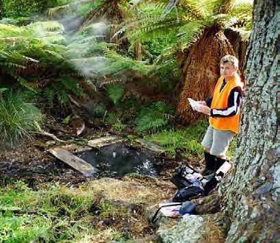
Table of Contents
Acknowledgement                                                     i
Abstract                                                           1
1          INTRODUCTION                                            2
2          EXPLANATORY NOTES                                       4
     2.1     Spatial hierarchy of geothermal manifestations         4
     2.2     Waikato Regional Council Policy Considerations         4
     2.3     Sinter-forming Springs                                 5
     2.4     Geysers                                                5
     2.5     Condition and Threats                                  7
     2.6     Spring Location Identification                         8
     2.7     Chemical Analyses                                      8
3          ATIAMURI                                                9
     3.1     Atiamuri Springs                                       9
     3.2     Chemistry of Atiamuri System:                        12
4          HOROHORO                                               13
     4.1     Horohoro Springs                                     13
     4.2     Chemistry of Horohoro System                         14
5          MANGAKINO                                              15
6          MOKAI                                                  16
     6.1     Waipapa                                              16
     6.2     Ongaroto                                             16
     6.3     Paerata                                              17
     6.4     Chemistry of Mokai System                            17
7          NGATAMARIKI                                            18
     7.1     Southern Orakonui Springs                            18
     7.2     Central Orakonui Springs                             19
     7.3     Northern Orakonui Springs                            19
     7.4     Waikato River Springs                                20
     7.5     Chemistry of Ngatamariki system                      21
8          OHAAKI                                                 22
     8.1     Ohaaki Springs                                       22
     8.2     Chemistry of Ohaaki System                           23
9          ORAKEI KORAKO                                          24
     9.1     Waihunuhunu Valley                                   24
     9.2     Papakainga                                           25
     9.3     Te Kapua (Waipapa Valley)                            25
     9.3.1   Rainbow Terrace                                      26
     9.3.2   Golden Fleece Terrace                                30
     9.3.3   Artist’s Palette Terrace                             33
     9.4     Red Hills                                            41
     9.5     Chemistry of Orakei Korako System                    42
10         REPOROA                                                43
     10.1    Opaheke Springs (a.k.a. Opateketeke)                 43
     10.2    South-east Springs                                   43

Page ii                                                       Doc # 15980020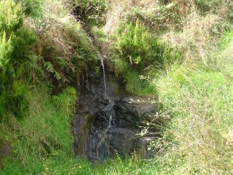
10.3   Longview Road Springs                                                         44
     10.4   Chemistry of Reporoa Hot Springs                                              45
11      ROTOKAWA                                                                          46
     11.1   Lagoon Springs                                                                46
     11.2   Chemistry of Rotokawa hot springs                                             47
12      TAUHARA                                                                           48
     12.1   Tauhara Springs                                                               48
     12.2   Extinct Geysers and Hot Springs of Tauhara:                                   49
     12.3   Chemistry of Tauhara hot springs                                              50
13      TE AROHA                                                                          51
     13.1   Te Aroha Springs and Bores                                                    51
     13.2   Chemistry                                                                     51
14      TE KOPIA                                                                          53
     14.1   Murphy’s Gully Springs                                                        53
     14.2   Te Kopia Springs                                                              53
     14.3   Chemistry                                                                     54
15      TOKAANU                                                                           56
     15.2   Chemistry of Tokaanu hot springs                                              63
16      TONGARIRO                                                                         65
     16.1   Ketetahi Springs                                                              65
     16.2   Chemistry                                                                     65
17      WAIHI                                                                             66
     17.2   Chemistry                                                                     66
18      WAIKITE                                                                           67
     18.1   Waikite Springs                                                               67
     18.2   Chemistry of Waikite Valley hot springs                                       71
19      WAIOTAPU                                                                          72
     19.1   Waiotapu Springs                                                              72
     19.2   Chemistry of Waiotapu Hot Springs                                             76
20      WAIRAKEI                                                                          78
     20.1   Wairakei Springs                                                              78
     20.2   Extinct Geysers and Hot Springs of Wairakei                                   78
     20.3   Chemistry of Wairakei Hot Springs                                             80
21      SUMMARY OF GEYSERS AND SINTER-FORMING SPRINGS                                     81
References                                                                                82

Maps
Map 1: Geothermal Resources of the Waikato and Bay of Plenty Regions (Courtesy of New Zealand
           Geothermal Association and GNS Science Ltd)                                      3

Figures
Figure 3-1: Matapan Rd Spring                                                              9
Figure 3-2: Southern Spring, Whangapoa                                                    10
Figure 3-3: Northern Pool, Whangapoa                                                      11
Figure 4-1: Waipupumahana                                                                 13
Figure 4-2: Gully spring                                                                  14

Doc 15980020                                                                                    Page iii
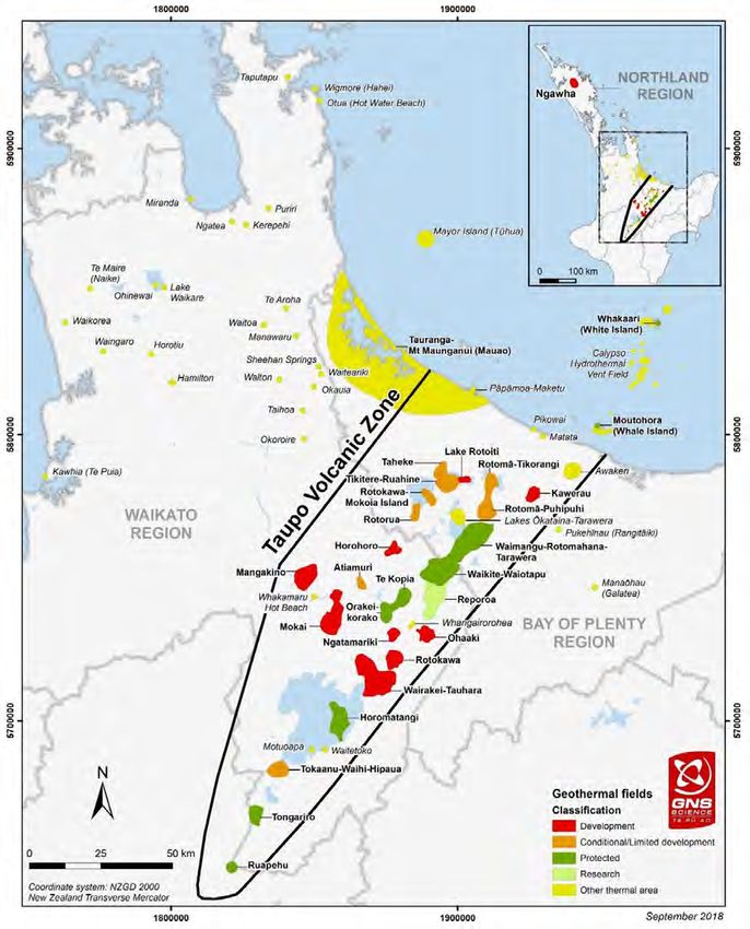
Figure 5-1: Sinter springs discharge on the bed of Lake Maraetai                          15
Figure 7-1: Southern Spring partially covered by cyanobacterial mats and pumiceous debris 18
Figure 7-2: Outlet from Calcite Spring in 1995. Copyright Shaun Barnett.                  19
Figure 8-1: Ohaaki Pool before it was affected by extraction. Copyright Ron Keam.         22
Figure 9-1: Map of Australia on 11 February 2020. Copyright Jesse Ledwin Lebe.            25
Figure 9-2: Diamond Geyser Erupting in 2004.                                              26
Figure 9-3: Bush geyser in 2004.                                                          26
Figure 9-4: Cascade geyser in 2004.                                                       27
Figure 9-5: Sapphire geyser in 2004.                                                      27
Figure 9-6: My Lady’s Lace with a high water level.                                       28
Figure 9-7: Fred and Maggie pools in 2003.                                                30
Figure 9-8: An overflown Manganese Pool with visible conophyton stromatolite growths in
             February 2020. Copyright Jesse Ledwin Lebe.                                  31
Figure 9-9: Cauldron geyser in 2003.                                                      31
Figure 9-10: Dreadnought geyser in 2004.                                                  32
Figure 9-11: Wairiri Geyser erupting in 2004.                                             32
Figure 9-12: Dry Kurapai Geyser in 2004.                                                  33
Figure 9-13: An overflowing Palette Pool on February 2020. Copyright Jesse Ledwin Lebe.   34
Figure 9-14: OKF0760/1 erupting in 2004.                                                  37
Figure 9-15: OKF0774 (left) and OKF0773 (right) in 2003.                                  37
Figure 9-16: OKF0806 in 2004.                                                             39
Figure 9-17: Pyramid of Geyser on February 2020. Copyright Jesse Ledwin Lebe.             40
Figure 10-1: Māori Spring in 2004.                                                        43
Figure 10-2: South Spring in February 2020.                                               44
Figure 10-3: Longview Road features in 2003.                                              44
Figure 11-1: RKF3 on February 2020. Copyright Jesse Ledwin Lebe.                          46
Figure 13-1: Mokena Geyser erupting to ~1.5 m high in 2012.                               51
Figure 14-1: Te Kopia Mud Geyser erupting in 2009.                                        54
Figure 15-1: Te Korokoro A Te Poinga in 2000. Copyright Ashley D Cody.                    56
Figure 15-2: Tuwhare Spring in 2005.                                                      57
Figure 15-3: Taumatapuhipuhi Geyser in 2005.                                              58
Figure 15-4: Matewai Spring in 2005.                                                      59
Figure 15-5: One of the three Hoani Springs in 2004.                                      60
Figure 15-6: Te Paenga Springs in 2004.                                                   60
Figure 15-7: Teretere Spring in 2004.                                                     62
Figure 15-8: Healy's Bore No.2 in 2004.                                                   62
Figure 18-1: HT Geyser in 2003.                                                           67
Figure 18-2: Scalding Spring in 2009.                                                     68
Figure 18-3: Te Manaroa Spring with travertine in 2013.                                   69
Figure 19-1: Champagne Pool in 2019.                                                      73
Figure 19-2: Waiotapu Geyser in 2004.                                                     73
Figure 19-3: Lady Knox Geyser on February 2020. Copyright Jesse Ledwin Lebe.              74
Figure 19-4: Jean Batten Geyser in 2004.                                                  75
Figure 19-5: Venus Bath in 2004.                                                          75
Figure 19-6: NW Boardwalk Geyser 2004.                                                    75
Figure 19-7: Hakareteke Geyser in 2004.                                                   76
Figure 20-1: Great Wairakei Geyser in 1929. Copyright B Dickie.                           78
Figure 20-2: Pink Terrace, Wairakei, in 1929. Copyright B Dickie.                         80

Tables
Table 1: Chemistry of Atiamuri hot springs                                               12
Table 2: Chemistry of Horohoro hot springs                                               14
Table 3: Chemistry of Mokai hot springs                                                  17
Table 4: Chemistry of Ngatamariki hot springs                                            21
Table 5: Chemistry of Ohaaki Pool, Broadlands                                            23
Table 6: Chemistry of Orakei Korako hot springs                                          42
Table 7: Chemistry of Reporoa hot springs                                                45
Table 8: Chemistry of Rotokawa hot springs                                               47
Table 9: Chemistry of Tauhara hot springs                                                50
Table 10: Chemistry of Te Aroha Springs                                                  52

Page iv                                                                             Doc # 15980020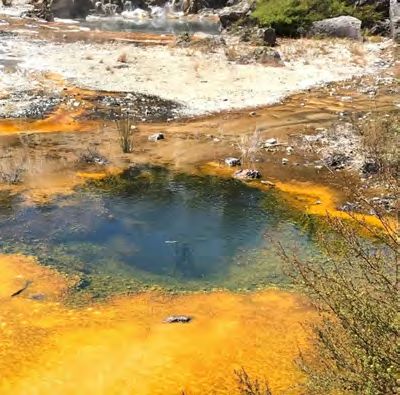
Table 11: Chemistry of Te Kopia Springs                       55
Table 12: Chemistry of Tokaanu hot springs                    64
Table 13: Chemistry of Tongariro Springs                      65
Table 14: Chemistry of Waihi Springs                          66
Table 15: Chemistry of Waikite Valley hot springs             71
Table 16: Chemistry of Waiotapu hot springs                   77
Table 17: Chemistry of Wairakei hot springs                   80
Table 18: Summary of sinter-forming hot springs and geysers   81

Doc 15980020                                                       Page v
Abstract
Sinter-forming springs and geysers are among the rarest, the most vulnerable, the most
spectacular and the most prized among the Waikato Region’s geothermal surface features.
This report provides an inventory of sinter-forming springs and geysers in the Waikato Region,
and provide notes on their location, activity, characteristics, and any threats that they face. It is
hoped that this report will assist the preservation of these features by providing a guide to assist
further monitoring.

There are 169 sinter-forming springs in the Waikato Region, down from 668 in the 1950s, and
51 geysers, down from 161. The greatest loss of features was caused by the inundation of many
features at Orakei Korako when the Ohakuri Dam was constructed for hydroelectric electricity
generation, and by the extinction of features on the Wairakei-Tauhara Geothermal System due
to the large-scale extraction of deep geothermal fluid for the Wairakei Power Station.

Waikato Regional Council’s policy framework under the Resource Management Act 1991 (New
Zealand Government 1991) now protects these features and so there has been little change in
numbers since the 1990s when the policy was formed.

Doc # 15980020                                                                                 Page 1
1   INTRODUCTION
    One of the Waikato Regional Council’s statutory requirements, as set out in the Resource
    Management Act (1991) Section 35, is to describe the state of the regional environment. In
    conformity with that requirement this document aims to describe the current state (“condition”)
    of all known sinter-forming hot springs and geysers in the Waikato Region.

    Geothermal surface features are rare internationally, nationally, and regionally. Geysers and
    sinter-forming springs are among the rarest, and the most prized as a tourist and scientific
    resource. They are also the most vulnerable to adverse effects from both large-scale extraction
    of geothermal fluid and surface interference.

    New Zealand has more geothermal resources than many nations, and a significant proportion of
    the world’s geysers and sinter-forming springs are concentrated within the Waikato Region
    (Bryan, 2018). The number of geysers and sinter-forming springs within the Waikato Region
    dropped sharply in the mid- to late-20th century due to geothermal power developments and
    other human effects.

    The Waikato Regional Policy Statement (RPS) classifies some types of geothermal features as
    Significant Geothermal Features and sets out issues, objectives, policies, implementation
    methods, and rules relating to their protection. Geysers, hot springs, recent sinter, and mud
    geysers are all listed as Significant Geothermal Features.

    The RPS also classifies the Region’s geothermal systems into five usage categories and sets out
    issues, objectives, policies, environmental results anticipated, and implementation methods
    including rules relating to the activities that may be carried out on each type of system.

    With human activity having caused many of the changes that have occurred within historical
    times and with Waikato Regional Council’s responsibility to protect the environment within the
    Waikato Region, a key aspect of this report is an assessment of the vulnerability of each
    individual feature to artificial modification.

    This document thus provides an inventory of geysers and sinter-forming hot springs in the
    Waikato Region, the changes that have occurred to their number and condition, and the threats
    that they face. It is hoped that this report will provide practical information for the purposes of
    policy development and public education, act as a baseline for further reports, and be a useful
    resource for researchers in the field.

    Each feature is listed under the geothermal system in which it is found, it is briefly described, its
    location is detailed, some historical details are provided, and references to further information
    about it are given. Those features that have become inactive or have been inundated recently
    are also noted, although, in general, fewer details are provided in these cases.

    There may be springs in existence that do not appear in this report. The authors therefore
    welcome any corrections or additions, details of which should be addressed to Katherine
    Luketina at Waikato Regional Council (katherine.luketina@waikatoregion.govt.nz).

    Page 2                                                                                Doc # 15980020
Map 1: Geothermal Resources of the Waikato and Bay of Plenty Regions (Courtesy of New Zealand
Geothermal Association and GNS Science Ltd)
Doc # 15980020 Page 32 EXPLANATORY NOTES
2.1 Spatial hierarchy of geothermal manifestations
A geothermal system is an individual body of geothermal energy (including geothermal water),
material containing heat or energy surrounding any geothermal water, and all plants, animals,
micro-organisms and other characteristics dependent on the geothermal energy. There are
fifteen such systems in the Waikato Region (Map 1).
A geothermal system may contain more than one geothermal field. A geothermal field is an area
of separate upflow with its own set of surface features, for example the Wairakei and Tauhara
fields in the Wairakei-Tauhara geothermal system.
The term ‘field’ is sometimes used by others to denote an area of geothermal surface features.
For example, the Tokaanu, Waihi and Hipaua ‘fields’ on the Tokaanu-Waihi-Hipaua geothermal
system are separate sets of features but they are all fed by the same upflow. That meaning is
not used in this document.
Geothermal features are the surface manifestations of a deep geothermal resource. They
include hot or steaming ground, hot springs and pools, deposits of silica (sinter), sulphur, and
other minerals, mud pool, and fumaroles. A feature or geographical group of features usually
has a thermophilic or thermotolerant ecosystem associated with it. A field may contain many
groups of such features, which in turn may be logically divided into several subgroups depending
on the geography of the area.
The listing of springs in this document follows the hierarchy of field, group, subgroup and then
spring. Within each group, the springs are listed according to their geographical location rather
than in numerical sequence of the spring numbers.
2.2 Waikato Regional Council Policy Considerations
The RPS identifies five types of geothermal system and sets outs the uses of geothermal
resources that may be undertaken in each system. There are 15 large systems within four
categories and numerous isolated sets of warm springs in the Small Geothermal System
category. There is only one spring in a Small Geothermal System that is listed in this document.
The RPS lists Protected Geothermal Systems. The remaining large geothermal systems are
identified in the Waikato Regional Plan. The categories are:
In Development Geothermal Systems, development may occur, and any adverse
effects on geothermal features must be avoided, remedied and mitigated. There are
seven Development Geothermal Systems: Horohoro, Mangakino, Mokai, Ngatamariki,
Ohaaki, Rotokawa and Wairakei-Tauhara.
In Limited Development Geothermal Systems, only development that does not affect
geothermal features may take place. The two systems in this category are Atiamuri and
Tokaanu.
Research Geothermal Systems are those for which there is insufficient information to
classify them otherwise. In these systems only small takes for general uses and larger
takes for research may occur. The only system in this category is Reporoa.
Protected Geothermal Systems are those which have a large number of Significant
Geothermal Features that are to be protected by an almost absolute restriction on
takes. The five systems in this category are: Horomatangi, Orakei Korako, Te Kopia,
Tongariro, and Waikite-Waiotapu-Waimangu.
Page 4 Doc # 15980020 In Small Geothermal Systems takes are permitted as long as they are at a sustainable
level and do not adversely affect any geothermal features. There are approximately 30
small systems in the Waikato Region. Their names and indicative locations are found
on Map 1 above.
These classifications affect the level of protection and the degree of threat that each geothermal
feature listed in this document faces.
2.3 Sinter-forming Springs
As near-neutral, alkali-chloride1, hot spring water discharges at the surface, it cools to
temperatures of less than 100 °C and silica precipitates to form a rock type known as sinter,
mediated by microbial communities that thrive in the discharging thermal fluid (archaea,
cyanobacteria, diatoms, etc.). Over time, the depositing silica coats, entombs and silicifies all the
components within the spring channel, fossilising them within the sinter.
Discharging alkali-chloride fluids are of deep geothermal origin and are chemically distinct from
the water of other hot springs, which is either steam heated ground water, or a mixture of
geothermal fluid and ground water. Some springs discharge near-neutral, alkaline chloride
water but form an acidic pool. This occurs when sulphur is distributed throughout the water and
the pool has a large surface area which allows the sulphur to oxidise at the surface and form
sulphuric acid. Although these pools appear to be acidic, the deep thermal fluid feeding the pool
is in fact, near-neutral alkaline chloride fluid. Therefore, pH alone is not a reliable indicator of
deep fluid input. The key indicator of the proportion of deep geothermal fluid present is the
chloride concentration in the spring water compared with neighbouring springs.
Deposits of silica can also accumulate at the surface of geothermal fields by the reaction with
silicate country rocks by steam condensate acidified by sulphuric acid, derived from oxidation of
H2S (White et al., 1956; Rodgers et al., 2002).
2.4 Geysers
The RPS defines a geyser as:
“Any naturally occurring geothermal spring that occasionally or frequently erupts
producing an intermittent or continuous discharge by the evolution of a phase
dominated by steam or other gases, vigorous enough to eject forcefully liquid
water by surging, boiling, throwing, splashing, or jetting it into the air above a static
water level or vent opening. This includes hot water geysers, perpetual spouters,
soda geysers, and crypto-geysers. The area of a geyser comprises that of the spring
basin and the area covered (perhaps intermittently) by surface water composed of
the undiluted discharge from the geyser, and by any sinter deposits created by that
discharge.“
The intervals between geyser eruptions can vary over minutes to hours or days, as can the
duration of eruptions. However, there is often some regularity or predictability involved in their
1
Mineral waters have been traditionally named (in short hand) by their dominant dissolved
cation (Na, K, Ca, etc.) and dominant anion (chloride, bicarbonate, sulphate, carbonate, etc.).
Since there are fewer anions than cations to compete for dominance, the shorthand name often
just includes the anion. “Alkali-chloride” is a shorthand term for a water name otherwise based
upon the full chemical analysis. “Alkali-chloride” names the dominant cations (the alkali metals
Na, K, Mg, Ca, Li, etc) with the anion. In the Waikato Region, many sinter-forming chloride waters
come out at higher pH than neutral, and can be referred to as “alkaline” waters.
Doc # 15980020 Page 5behaviour. Worldwide, geysers are rare and appear to be short-lived phenomena on a geological timescale. Inactivity of geysers may be due to natural conditions such as the self-sealing of vents due to sinter deposits or a change in the fluid pathway that feeds the geyser. Alternatively their inactivity may be due to human interference with the parent geothermal systems, e.g. by reducing feed pressure and water levels until geysers and sinter-forming springs can no longer discharge. Wairakei-Tauhara, Tokaanu, and Ohaaki have all lost geysers in such a manner. In addition Ohaaki, Mangakino, Atiamuri, Ngatamariki, Mokai, Rotokawa, and Orakei Korako have lost sinter-forming springs due to inundation of springs when hydro-electric lakes were created. Tokaanu-Waihi and Rotokawa have non-sinter-forming springs that are affected by lake and river level management. This document uses the term mud geyser for a naturally occurring geothermal mud pool that intermittently or continuously ejects liquid mud by surging, boiling, throwing, splashing, or jetting, more than two metres into the air above a static liquid level. Mud geysers erupt in a geyser action, but they do not constitute hot springs in that there is little or no input of deep geothermal fluid. Therefore, they do not fall under the RPS definition of a geyser. As with all mud features, the heat is supplied by steam, and the bulk of the water is supplied by rain. Eruptions from mud geysers are bigger by several orders of magnitude in terms of height reached and volume of mud ejected than the plopping action normally observed in a bubbling mud pool. There are only three mud geysers known in the Waikato Region, one at each of the Wairakei, Mokai, and Te Kopia fields. They are listed in this document because of their rarity, but are not included in the table of geysers at the end. Most geysers are sinter-forming springs and are surrounded by a sinter apron. Sinter acts as a sealant in the near-surface plumbing of the spring, assisting the build-up of steam and other gases necessary to initiate and power an eruption. Soda geysers are different in that the rock surrounding them consists of calcium carbonate and is referred to as travertine. The eruptive gas is dominantly carbon dioxide rather than steam, with the erupted water often being well below boiling temperature. The Waikato Region has one soda geyser, Mokena Geyser at Te Aroha. This is an artificial geyser, as it is actually an erupting well. Another subset of the geyser genre is the acid geysers. These generally do not form sinter or travertine, so the necessary gas-impermeability of their conduits must be a natural characteristic of the type or structural integrity of the surrounding rock matrix. Acid geysers exist at White Island in the Bay of Plenty Region and at Ketetahi and Waiotapu in the Waikato Region. The Ketetahi geysers do not deposit silica whereas the Waiotapu geyser deposits minimal silica. Crypto-geysers are underground hot springs periodically erupting so far below the surface that they do not eject a column of steam and water above the surface. They can be divided into two sub-groups, as described below. Submerged geysers have an overlying body of water. The site of eruption is so far below the water surface that the steam produced becomes condensed before reaching the surface, and so there is no two-phase ejection of fluid above the surface of the overlying pool. There is an increased flow from the pool as a result of the steam produced displacing water upwards, and because reduced pressure at the bottom of the steam column allows a greater inflow. Subterranean geysers erupt into underground open spaces at such depths that the eruptive column has insufficient upward thrust to reach the surface, and the only evidence of the eruption is a mixture of acoustic and seismic signals and an increased discharge from overlying steam features. Page 6 Doc # 15980020
Submerged geysers in the Waikato Region include but are not limited to Taumatapuhipuhi at
Tokaanu, the northern Whangapoa Spring at Atiamuri (Graham 2006) and the Map of Australia
at Orakei Korako. In the Bay of Plenty Region, Inferno Crater at Waimangu is a very large
submerged geyser, with its water level ranging approximately 7 metres and sometimes as much
as 12 metres from overflow to its lowest point over a cycle of six or seven weeks (Keam, 2002).
Parekohoru is one of several examples at Rotorua geothermal system, also in the Bay of Plenty
Region.
2.5 Condition and Threats
This document classifies springs into six categories depending on their condition. A spring may
be:
Unaltered: pristine or nearly pristine,
Largely intact: a moderate degree of alteration that could be readily remedied,
Recoverable: altered but with its unaltered state able to be substantially recovered,
Unrecoverable: altered with its unaltered state unrecoverable, or
Extinct: no longer flowing, but it may still exist as a sinter formation with or without
steam discharge.
There is an additional category of:
Inundated: now underwater due to management of Lake Taupō or the Waikato River
for hydroelectric generation. Such springs still exist and could be recovered if water
levels were reduced to expose the springs.
In addition, springs are classified according to whether their existence or characteristics are
severely threatened, moderately threatened, slightly threatened or hardly threatened from
anthropogenic interference. Due to the unpredictable and wide-ranging nature of
anthropogenic influences, it is not possible to have a feature that is completely protected from
human influence. The nearest you can get is the ‘hardly threatened category. Natural influences
are not considered in the threat category.
An extinct spring may still hold the classification of ‘threatened’. This is because sinter deposits
and subsurface plumbing may have their own aesthetic, scientific, cultural or intrinsic value.
Thus an extinct spring may be vulnerable to alteration if the sinter or other characteristics risk
being degraded or destroyed. The document makes clear when discussing such features that it
is the remnant sinter that the threat classification refers to.
Several geothermal systems have had geysers and sinter-forming springs inundated when
hydroelectric lakes were created. This document does not classify the inundated springs as
extinct, as they would be likely to recover their activity if the Waikato River were returned to its
pre-dams water level at that point. Such springs are considered ‘recoverable’.
Flows from the springs at Orakei Korako that remain above lake level following inundation have
increased due to the rise in aquifer pressure caused by the rise in lake level. Therefore, unless
there is some other form of interference, this document considers the remaining above-lake
springs as ‘largely intact’ because the increase in their activity would be quickly remedied by
lowering of lake levels to natural levels.
On the Wairakei-Tauhara and Ohaaki geothermal systems, geysers and sinter-forming springs
have become inactive due to their flow being diverted to geothermal wells. The springs have
stopped flowing and cannot be recovered, probably for hundreds of years at least following
closure of the wells. They are essentially ‘extinct’. Remaining sinter deposits and steam-fed
features are threatened by human activity.
Doc # 15980020 Page 7At Tokaanu the geysers and sinter-forming springs have been depleted due to several factors,
including the continued discharge from an uncapped government exploration well drilled in
1942, and a well drilled more recently to provide steam to the Department of Conservation
baths (Hochstein, 2007). However, if these takes were discontinued the springs might return to
their previous eruptive behaviour, and so they are classed as ‘recoverable’.
Natural occurrences that may affect a spring’s behaviour or existence are not considered as
‘threats’ in this document. Such occurrences include naturally fluctuating river levels and rainfall
recharge rates, natural ground instability, weathering of sinter whose regenerating flow has
ceased naturally, and natural changes in spring flow. The weathering of sinters that are no longer
regenerating due to human interference is considered a human interference, and therefore a
‘threat’.
Some springs are located on land owned by the New Zealand Government and administered by
the Department of Conservation for conservation purposes, and therefore some legal protection
is afforded them. Other land may be legally protected in other ways such as through covenants.
In addition, the RPS and the Proposed Waikato Regional Plan give protection to all sinter-forming
springs and geysers by classifying them as Significant Geothermal Features and providing rules
for their protection. However, in geothermal systems classified as Development Geothermal
Systems, protection for extractive uses is not required, and instead, remediation or mitigation
of such adverse effects is allowed.
There are some situations where legally occurring human activities may unintentionally affect
springs and other situations where activities that affect springs have been authorised under the
Resource Management Act (1991) or other relevant legislation. In addition, there are cases
where springs are altered without legal authorisation. The legal protection status of the springs
in this document has been considered when assigning ‘threatened’ or ‘safe’ status, but the
primary factor in assigning status is the practical situation of what human-induced effects are
occurring, are likely to occur, or could reasonably occur.
2.6 Spring Location Identification
One problem when seeking information on a particular spring from such references is that there
is often inconsistency between documents regarding the names used for a particular feature.
Most references were written before the widespread use of GPS readings, which can now easily
be taken to an accuracy of a few metres or better. In order to minimise future confusion, the
known name(s) of each spring, its precise location to within metres, and a verbal description of
the spring’s location and appearance, are provided for most features where known.
Those seeking maps and aerial photos of the sites are referred to Wildlands (2014).
2.7 Chemical Analyses
Chemical analyses given are for indicative purposes. In some cases, analyses that are more
complete are referenced, but there may be other sources. Recent detailed chemical analysis of
many geothermal features is given by Webster-Brown and Brown (2010). Hampton et al. (2001)
provides a comprehensive list of geo-scientific references for each geothermal field.
GNS Wairakei, hold much information in paper records and an online database. Waikato
Regional Council holds monitoring records for some springs in an electronic database, and paper
records of water analyses received from resource consent holders. It is planned that in time
these records will be available electronically.
Page 8 Doc # 159800203 ATIAMURI
3.1 Atiamuri Springs
The Waikato Regional Plan classifies Atiamuri as a Limited Development Geothermal System,
meaning that development may proceed as long as there is no significant adverse effect on the
geothermal features. Mercury Ltd was granted resource consents for exploratory drilling in the
early 2000s; however, no drilling occurred.
Several hot springs are known in the Atiamuri system but only the two main springs, the
Whangapoa Springs, are forming sinter at present. These are located in a small Department of
Conservation (DOC) reserve near the intersections of Ohakuri, Matapan, and Ngautuku Roads
and are listed below. They have extensive historic sinter deposits around them. Until recent
years they both had artificial channels dug to contain the outflow. The southern spring has a
regenerated sinter terrace following restoration work by DOC in 2002 that included blocking the
discharge channel and channelling the discharge to the west of the pool, creating a new sinter
terrace. The discharge channel of the northern feature was originally dug to supply a large
swimming pool, which no longer exists. Sinter deposits have formed in and around the discharge
channel depositing silica wherever the water flows.
West of the Whangapoa Springs is a sinter-lined extinct spring vent of a similar size to them. It
is about 20 m in diameter and about 10 m deep. It had a warm pool in the bottom with algae
growing in it. However, its vent was filled in by the landowner in 2003.
The extinct spring vent and the Whangapoa Springs are found in an area that was previously in
pine. In 2002, the forestry company Carter Holt Harvey Limited (CHH) sold the land to a private
owner and it was cleared for farming. CHH gifted the land surrounding the Whangapoa Springs
to DOC, who have fenced it off. DOC is undertaking an ongoing programme to re-establish native
plants on the margins, replacing first pines then blackberry. On the farm track leading from the
Whangapoa Springs to the extinct spring vent, altered earth can be seen.
Also on the farm property is a boiling mud pool about 6 m in diameter and a warm pool filled
with clear water of about 45 C and neutral pH. The pool is in a vent that is lined with thick sinter.
It is clear that in historic times the pool was once an overflowing silica-forming spring, but now
the nearby stream undercuts it and it may discharge through the ground into the stream.
In an arm of Lake Atiamuri about 0.5 km west of the two main hot springs there is a small hot
spring, which was flooded by the filling of the lake in January 1961. This was a silica-forming
spring. It still produces hot water and
bubbles, and dead fish can sometimes be
found near it. It is not known why the fish
die but thermal stress is a likely cause.
There are several springs in the vicinity
that are considered not to be part of the
Atiamuri system. These include springs in
the stream immediately north of the
intersection of Ohakuri and Parsons
Roads, and near the stream-bed north-
east of Matapan Road.
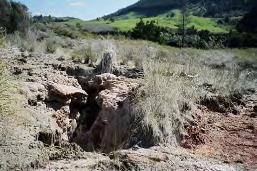
At the north end of Matapan Road a hot
Figure 3-1: Matapan Rd Spring spring produces clear water of about 70
C that flows at about 0.2 litres per
second (L/s) from a fissure in the ignimbrite cliff, but no sinter deposits occur here. It has a
Doc # 15980020 Page 9growth in its outflow of a cream-coloured, gelatinous mass measuring approximately 20 cm by
30 cm in area, and 2 to 3 cm in depth. It has a spongy consistency and resembles a brain.
Approximately 1 km upstream of the Ohakuri dam, on the western bank of the river, a hot spring
discharges from a cliff face. This spring has not been investigated by Waikato Regional Council
at the time of writing. It can be accessed only by water.
In 2019 a warm spring was discovered during road maintenance on the Mangaharakeke Bridge
on State Highway One near the settlement of Atiamuri.
3.1.1.1 Feature Name: Southern Whangapoa Spring (Scalding Pool) [ATF3]
Type: Hot spring actively depositing silica to form sinter.
Condition: Recoverable. Affected by past forestry operations and current game-processing uses.
Threats: Slightly threatened. In an actively managed DOC reserve, but use by locals for
processing game has some adverse effect.
Location: NZMS-260 U16: 277605 E, 6311078 N +/- 5 m. Location measured from GPS (+/- 5 m).
Description: The spring lies about 100 m south of
Ohakuri Road, beside the farm access drive. The
spring is sub-circular, about 12 m in diameter,
with vertical walls visible beneath the surface. The
water is clear, has no odour, and occasionally
produces bubble swarms, probably caused by the
evolution of CO2. Since Waikato Regional Council
started monitoring the spring in 1995, the water
temperature has ranged between 55 and 70 C.
Sinters and coloured microbial mats grow along
Figure 3-2: Southern Spring, Whangapoa
an outflow channel heading due west that is
about 1 m wide at the pool outlet, and about 10 m wide at the fence that serves as its boundary
about 20 m downstream. It then flows into a wetland tributary of the Whangapoa Stream.
The spring is often used for scalding fur and feathers off game, and wooden pallets and other
temporary structures can sometimes be found around the shallows of the pool edge. Litter and
feathers, hair, bones, and other animal remains are also occasionally left around the pool
margins.
When the surrounding pines were cleared in 2002, logs and branches were left on the sinter flat
and became cemented in by silica deposition. DOC removed as much as they could without
damaging the sinter, but many branches still remain.
This pool and the northern pool are called by some authors the eastern and western pools
respectively, even though they are on an axis aligned almost exactly north-south, and the
scalding pool is marginally to the west rather than to the east.
History: There is no known Māori name or legend associated with the spring.
The outflow was artificially constrained to a narrow channel at some unknown time, probably
in the 1970s. This was successfully sandbagged by DOC in the early 2000s to encourage
regeneration of the sinter apron. The spring has been fenced off by DOC and warning signs have
been erected.
3.1.1.2 Feature Name: Northern Whangapoa Spring (Trough Pool) [ATF2]
Type: Hot spring actively depositing silica to form sinter.
Page 10 Doc # 15980020Condition: Recoverable. The spring’s natural head has been decreased several metres by an
artificial channel.
Threats: Slightly threatened. In an actively managed DOC reserve, but the artificial channel and
use of the outflow by locals for bathing has some adverse effect.
Location: NZMS-260 U16: 2776600 E, 6311132 N. Location estimated as 40 m north of Spring 1.
Description: The pool is oval, about 10 m long and 7 m wide with overhanging vertical walls
about 1.5 m high above water level. It has clear, lime green waters, no odour, a constant strong
bubble plume, and a strong convection. Surface sinters are exposed in the walls of the pool, and
there is very minor sinter growth along the channel. The flow is measured to be between 0.2
and 0.5 L/s. The pool temperature in January 2008 was 67 °C.
The pool fills a crater which may have been of hydrothermal eruption origin. Geothermal ferns
inhabit the steep sides of the crater.
Monthly monitoring by Mercury throughout
most of 2005 revealed that the spring has at
least two cycles – a four minute cycle in which
flow approximately range from 0.47 L/s to 0.67
L/s, and a cycle of the order of months in which
flow ranges at least as low as 0.32 L/s and at
least as high as 1.05 L/s. More frequent
monitoring on a daily or weekly interval would
be needed to determine the full range of the
variation. Temperature ranged from 65 to 72 C
Figure 3-3: Northern Pool, Whangapoa (Graham, 2006).
History: There is no known Māori name or legend associated with this spring. Grange (1937)
records a bath there.
Exposed sinters show that extensive sinter sheets once grew here. Fencing and land clearance
has exposed sinters right down to the wetland, covering an area of approximately 2 hectares.
This would have been similar in appearance to the sinter apron of Ohaaki Ngawha. It is not
known when the sinter became covered with top soil, but it is presumed to be due to a pre-
historic event such as a volcanic eruption. This must have occurred after the flow from the spring
waned, otherwise the outflow from the spring would have either washed the volcanic ash away
or deposited sinter on top.
The outflow was channelled to supply a concrete open-air swimming pool in the 1970s.
According to a local farmer, it was used and maintained by the local people, but after it was
repeatedly vandalised by other parties, it fell into disuse. The swimming pool was demolished
by CHH when the previous pine crop was logged in c. 1992. The spring outlet was then excavated
to form a trench about 1 m wide and about 1.5 m deep to divert flows down the hill until they
were sufficiently cool to be safe. A concrete trough has been installed in the outflow to be used
as a bath.
3.1.1.3 Feature Name: “Berg’s Crater” [ATF6]
Type: Large extinct spring vent with sinter and stone sides.
Condition: Recoverable. The vent has been filled in with logs and earth.
Threats: Severely threatened as it is at risk of further interference by the land owner. The
feature, not being a ‘recent sinter’ has no protection in the Waikato Regional Plan.
Doc # 15980020 Page 11Location: NZMS-260 U16: 2776278 E, 6311069 N +/- 5 m. Location estimated as 425 m west of
Southern Whangapoa Spring.
Description: On top of flat spur, south of the farm access drive and due west of the southern
Whangapoa Spring. In approximately 2003, the spring vent was filled in by the farmer using tree
stumps and dirt, because it was a risk to cattle. Before it was filled in, the crater was circular,
about 15 m in diameter at the top with near-vertical walls narrowing to a diameter of about 5
m at the bottom, which was approximately 20 m down. There was a non-flowing pool at the
bottom, possibly geothermal, with water plants floating on the surface. The water was stagnant,
with no steam or gas evolution.
The sinter-lined vent provided a rare opportunity to see the near-surface dimensions of a large
spring. The digging of posts for fencing has shown that there is sinter under the flat ground
around the top of the crater. The surrounding land has been cleared of pine and the crater
fenced off. The fill has started to degrade and slumping has occurred, so if the fill is not topped
up, at least the upper part of the vent should become visible again.
History: There is no known Māori name or legend associated with the crater.
3.1.1.4 Feature Name: No name known
Type: Inundated hot spring, no longer forming sinter.
Condition: Recoverable. The spring has been inundated by the creation of Lake Ohakuri.
Threats: Moderately threatened. The feature could be affected by development of the system
for geothermal electricity.
Location: NZMS-260 U16: 277600 E, 631170 N. Location measured from map sheet.
Description: In an arm of Lake Atiamuri about 0.5 km west of the two main hot springs there is
another small hot spring, which was flooded by the filling of the lake in January 1961. This was
a sinter-forming spring.
History: There is no known Māori name or legend associated with this spring.
3.2 Chemistry of Atiamuri System:
See also Hedenquist (1984) and Allis (1987), which give geothermometry source temperatures
of about 180 – 200 C.
Southern Spring initially showed transitional water chemistry between mature and peripheral
water in 1978, but showed mature compositions during later sampling programmes (1993 –
2009). Northern Spring also experienced water type maturation, initially being sampled as a
peripheral water in 2005, but samples from 2009 show a mature water composition.
Table 1: Chemistry of Atiamuri hot springs
(Webster-Brown, 2012)
Located Temp. pH Cl SO4 HCO3 SiO2
Spring Other ID Date
ID
(C) (parts per million)
15/03/78 69 8.7 328 41 565 280
Southern Historical: 8/07/93 66 7.4 354 49 589 262
Spring (ATF3) 3058_3 72_4387 11/05/94 70 7.3 362 49 620 272
17/08/09 60.3 7.6 300 38 19 140
Northern 3058_2 Historical: 4/10/05 56 8.4 343 45 267 280
Spring (ATF2) 72_3004 17/08/09 60.2 7.7 370 50 18 130
Page 12 Doc # 159800204 HOROHORO
Horohoro is a waning geothermal system, with very extensive extinct sinters, dried up spring
basins, and big hydrothermal eruption craters (Hedenquist, 1984). In recent historical time there
has been no boiling or geysering recorded here. Presently there are two hot springs depositing
insignificant sinters (Allis, 1987). The Waikato Regional Plan classifies Horohoro as a
Development Geothermal System. A glass house operation draws steam from a bore to heat the
glasshouse.
4.1 Horohoro Springs
4.1.1.1 Feature Name: Waipupumahana; Spring 1 [HHF1]
Type: Hot spring actively depositing silica to form sinter.
Condition: Recoverable. Altered by channelling and stock grazing the margins.
Threats: Moderately threatened by current land use practices.
Location: NZMS-260 U16: 2788383 E, 6323144 N +/- 10 m. Location measured from GPS (+/- 10
m).
Description: This is the largest active feature remaining in Horohoro. It is a circular pool about
12 m in diameter with vertical sinter walls on the eastern half of its circumference. It has clear,
blue water with a temperature around 50 °C, no odour, and occasional bubble swarms, most
likely caused by evolution of CO2. Since Waikato Regional Council started monitoring the spring
in 1995, the water temperature has ranged between 48 and 56 C. The outflow is about 0.5 to
1.0 l s-1.
The pool is on Māori land. A channel about
0.25 m wide x 0.3 m deep has been
excavated through the sinter wall to provide
a single concentrated channel outflow for
filling a bath. Consequently, there is no
longer the dispersed outflow necessary for
sinter accumulation. The owners have told
Ashley Cody that they have considered
blocking the channel to restore the pool to
its natural condition. However, this has yet
to occur. The pool would also benefit from
fencing off from stock, and planting the
Figure 4-1: Waipupumahana margins with native species. The steep bank
surrounding some of the pool is prone to
erosion and slumping into the pool.
History: There is a Māori legend associated with the pool; and a log lying across its northern end
is considered to be a taniwha named Korowhakatipua.
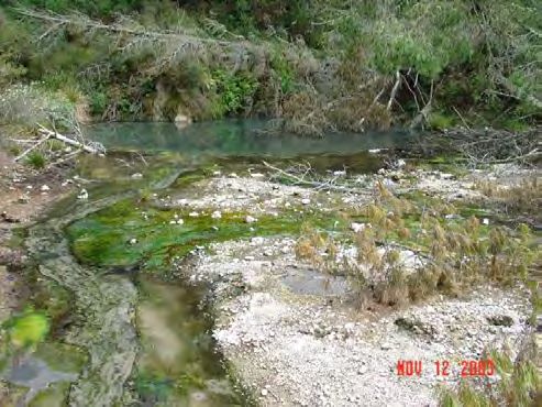
4.1.1.2 Feature Name: Un-named Gully Spring; Spring 2 [HHF2]
Type: Hot spring weakly depositing silica to form sinter.
Doc # 15980020 Page 13Condition: Unaltered.
Threats: Moderately threatened by land use
practices in surrounding farmland. Drainage of
the swampy gully would modify the spring.
Location: NZMS-260 U16: 2788066 E, 6322908
N +/- 10 m. Location measured from GPS (+/-
10 m).
Description: This shallow pool is sub-circular
with a diameter of about 2 m, and in 2008 had
a temperature of 90 °C. It has peaty walls and
substrate. It produces clear water with
Figure 4-2: Gully spring occasional bubbles, and has an outflow of
about 0.1 L/s. It lies at the base of a steep slope
in a swampy gully about 200 m south of an old homestead. It has white sinters deposited as thin,
sparse rinds; thick or massive sinter deposits are absent. The wooden boxing around it is evident
in the above photo (Figure 4-2), which was taken in the early 2000s, and has since largely rotted
away.
History: No known Māori name or legends. No known European history.
4.2 Chemistry of Horohoro System
See also Hedenquist (1984) and Allis (1987). Geothermometry gives source temperatures of
approximately 165 C.
Water samples taken from 1980 to 2005 (excluding 1963 and 1985 due to absence of HCO3 data)
from Waipupumahana spring show water chemistry progressing from peripheral waters with
70% HCO3, to more mature compositions with over 55% Cl composition. The spring chemistry is
observed to return to a more transitional chloride-bicarbonate composition in 2009.
Table 2: Chemistry of Horohoro hot springs
(Webster-Brown and Brown, 2012)
Located Temp. pH Cl SO4 HCO3 SiO2
Spring Other ID Date
ID (oC) (parts per million)
6/11/63 47 8.7 155 40 152
4/02/80 55 8.5 168 45 285 149
17/04/84 50 8.4 169 41 244
Waipupumahana 3059_1 Historical: 4/02/85 52 8.3 172 42 152
(HHF1) 72_3006 8/07/93 44 8.3 150 37 159 140
11/05/94 47 8.4 168 41 177 150
4/10/05 48 8.4 143 38 85 155
22/07/09 45 8.4 150 36 150 150
Page 14 Doc # 159800205 MANGAKINO
There were seven known hot springs, including one sinter-forming spring, on the Mangakino
system, in what is now the bed of the Waikato River and an arm of the river just south-west of
the well MA1, between about T16: 535-110 and T16: 545-130 (G. Risk, pers. comm, 2002). These
were inundated by the creation of Lake Maraetai for hydroelectric generation.
Mangakino is a Development Geothermal System. The resource has been subject to
investigation over the last few decades. In 1986, the Crown drilled an investigation well (MA1)
to a depth of approximately 600 metres. Carter Holt Harvey conducted some further shallow
drilling during the 1990s. Mercury drilled four deeper wells in 2005, but did not obtain good
permeability for production.
5.1.1.1 Feature Name: Unknown
Type: Inundated hot spring previously depositing silica to form sinter.
Condition: Inundated.
Threats: Severely threatened. If development occurred, the spring would probably cease
flowing.
Location: NZMS-260 T16: 530 110. Location approximate only, from Mongillo and Clelland 1984.
Description: A boiling, sinter-forming spring near the Mangakino township, now inundated by
Lake Maraetai (G. Risk, pers. comm.).
History: None known.
Figure 5-1: Sinter springs discharge on the bed of Lake Maraetai
Doc # 15980020 Page 156 MOKAI
There are hot springs scattered around various parts of the Mokai geothermal system, but most
of the activity is found in three main sets of features (Glover & Klyen, 1989). Most of the springs
in the South Paerata Rd area of the system are steam-fed which includes a mud geyser. Another
set of springs along the Waipapa Stream is depositing minimal sinter. There is a set of springs
due north of these, on the banks of the Waikato River, but these are generally underwater. Hot
springs, steam and sinter were recorded in the Ongaroto Gorge prior to the filling of Lake
Whakamaru in 1956, built for hydroelectric purposes (Cave et al. 1993, Glover & Klyen, 1989).
There was a hydrothermal blow-out near these springs when the railway was being constructed
across the Waikato River (Grange, 1937, p. 97). Mokai is a Development Geothermal System and
supports a 100 MW geothermal power station, a 12 hectare geothermally heated glasshouse
operation growing tomatoes and capsicums, and a geothermally heated milk powder plant.
6.1 Waipapa
6.1.1.1 Feature Name: Waipapa Stream Springs (Mulberry Road)
Type: Approximately five hot springs depositing minimal silica to form sinter.
Condition: Unaltered, not threatened.
Threats: Moderately threatened. The springs are protected by the Waikato Regional Plan.
However, land-use activities could cause damage at the surface. Most of the springs are in a
deep gorge and are fairly inaccessible, and therefore safe from structural interference. The
outflows could possibly be affected by large-scale fluid draw-down by the Tuaropaki geothermal
power station, and shallow reinjection of that fluid in the future, but at the current rate of
extraction this is unlikely.
Location: NZMS-260 T17, a line along the stream bed from: 2767784 E, 6300470 N to 2767902
E, 9301297 N. Location from GPS (+/- 5 m).
Description: A group of hot, clear springs discharging through boulders and hill slope colluvium
into the Waipapa Stream, in the bottom of a steep gorge. Some have very minor, thin sinter
margins a few millimetres wide at the water edges, but there is neither conspicuous
accumulation of any sinters nor any historic deposits. The outflows, several flowing at up to 0.5
L/s, mingle into the cold stream and swampy margins.
History: No Māori names or legends are known. A Māori rock drawing in ancient style (B. Jones,
pers. comm.) is situated in the area (Merrett et al., 1999), and was drawn in recent years (Robin
Black, pers. comm.). The surrounding land use has changed in recent years from forestry to dairy
pasture.
6.2 Ongaroto
6.2.1.1 Feature Name: Ongaroto Springs
Type: Sinter-forming springs.
Condition: Inundated.
Threats: Hardly threatened. The outflows could possibly be affected by large scale fluid draw-
down by the Tuaropaki geothermal power station and shallow reinjection of that fluid, in the
future but at the current rate of extraction this is unlikely.
Location: NZMS-260 T17: 2769000 E, 6305300 N. Location approximate only, taken from map.
Page 16 Doc # 15980020Description: No details have been found.
History: No Māori names or legends are known. Inundated by the creation of Lake Whakamaru
in 1956 for hydroelectric purposes.
6.3 Paerata
6.3.1.1 Feature Name: Mokai Mud Geyser
Type: Intermittently geysering mud pool.
Condition: Recoverable.
Threats: Moderately threatened. This site is heavily grazed and trampled by cattle. Blackberry is
extensive in the areas not accessed by cattle. There is graffiti on the sides of the mud geyser and
refuse in a nearby fumarole. The area surrounding the features should be fenced and planted
with appropriate native plants.
Location: NZMS-260 T17: 2765570 E, 6295100 N. Location from GPS (+/- 5 m).
Description: East of Paerata Rd about 1.5 km north of Forest Rd. Three km north-east of Mokai.
History: No history is known for this spring.
6.4 Chemistry of Mokai System
See also Henley and Glover (1980), whose results give geothermometry source temperatures of
150-180 C.
The chemistry of water samples from Waipapa Spring steadily show mature water compositions
between 1978 and 2009. Parekiri Pool has a very bicarbonate-rich peripheral water chemistry
typically observed in outflow areas. West Mokai Bath Spring has a transitional mature-volcanic
water chemistry, with a higher proportion of chloride to acid sulphate.
Table 3: Chemistry of Mokai hot springs
(Webster-Brown and Brown, 2012)
Spring Located Other ID Date Temp pH Cl SO4 SiO2 HCO3
ID
(oC) ( parts per million)
3/05/78 58 7.0 370 7 130 90
8/04/80 58 6.4 370 8 137 155
Waipapa Spring 14/06/82 59 6.3 371 4 139
3062_42 Historical:
(North Mokai) 19/10/83 58 6.6 362 9 144 119
72_4386
15/07/93 60 6.5 380 8 130 119
3/05/94 61 6.5 371 7 129 152
17/08/09 54.5 7.2 480 5.4 160 120
8/04/80 6.1 39 9 118
Parekiri Pool 3062_17 Historical: 14/06/82 6.1 35 5
(MKF1) 68_729 19/10/83 49 9.1 29.1 20 139
Mistakenly called 15/07/93 49 6.3 31.2 5 117 961
South Mokai 3/05/94 52 6.3 347 NGATAMARIKI
The Ngatamariki system is classified as a Development Geothermal System in the Waikato
Regional Plan. The 110 MW Ngatamariki geothermal power station has been operating since
2013. There are currently five sets of features actively depositing calcium carbonate and forming
travertine, and one actively depositing silica to form sinter. One set of springs was partially
inundated by the creation of Lake Ohakuri in 1961. The area is highly dynamic, with new features
appearing from time to time. In about 1948 a significant hydrothermal eruption occurred at
Ngatamariki. The noise was heard by the resident guide at Orakei Korako, and the Waikato River
was discoloured for several days. Another large hydrothermal eruption occurred in April 2005
at the southern Orakonui Springs (Cody 2005bb).
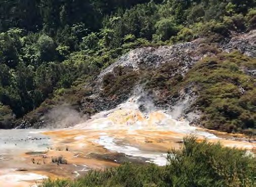
7.1 Southern Orakonui Springs
7.1.1.1 Feature Name: Southern Spring (Eruption Crater) [NMF1]
Type: Hot spring weakly depositing calcium carbonate to form travertine.
Condition: Unaltered.
Threats: Moderately threatened. It is vulnerable to pine plantation logging works damaging it.
Future geothermal extractions could affect the feature. In addition, stream flooding or scouring
could modify the spring.
Location: NZMS-260 U17: 2786600 E, 6291800 N. Location from GPS (+/- 5 m).
Description: When Waikato Regional Council started monitoring the Ngatamariki Springs in
1995, this was a neutral, hot, clear, bubbling spring about 7 m in diameter. It had very thin, 5
mm wide margins of carbonate-silica precipitates around the edges and on branches dipping
into the pool. The outflow was concentrated into a narrow channel. There are no significant
travertine or sinter accumulations present. The temperature ranged from 69 to 91 C, and the
approximate flow from 0.25 L/s to 3 L/s. Over the years to 2005, the activity of this spring
increased and several new hot springs broke out around it.
On 19 April 2005, this spring was the
site of a large hydrothermal eruption
which led to the formation of a crater
pool. A mud pool also formed on the
east side of the crater. Intense rain
events have scoured and deposited
pumice gravels from proximal slopes
and crater walls into the lake. This
causes the pool to be completely
infilled by sediments such as in 1999
(Cody 2000), or partially infilled as
observed in 2020, turning the water
colour into dark brown.
History: No name, use, or legend Figure 7-1: Southern Spring partially covered by cyanobacterial
known. mats and pumiceous debris
7.1.1.2 Feature Name: New Southern Geyser
Type: A boiling spring, actively depositing calcium carbonate to form travertine, formerly a
geyser.
Condition: Unaltered.
Page 18 Doc # 15980020Threats: Moderately threatened. Future geothermal extractions could affect the feature.
Location: NZMS-260 U17: 2786610 E, 6291715 N. Location from GPS (+/- 10 m). About 20 m
south from the main southern spring pool (Cody, 2000).
Description: A boiling and flowing spring in a marshy, soft ground beneath a vertical bank of
pumice gravels. This spring was formed in December 1999, when a fresh bank collapsed, blocked
an upflow, which then filled a cavity behind the landfill and overflowed 0.5 m above the marshy
pool alongside. The new spring against the wall is about 0.8 m long x 0.5 m wide, and produces
clear alkaline water, with a conspicuous white sinter rind forming on the bank at the surface.
For many months this pool had a true geysering action when it would begin boiling and geyser
between 0.1 m to 0.3 mm, high with an outflow of between 0.2 L/s to 0.5 L/s lasting up to one
minute. It would then stop flowing for about 10 minutes or more, before commencing the next
eruption. By March 2000, the surrounding ground collapsed to leave a big open pool that does
not geyser, but is still warm and depositing a sinter rim (Cody, 2000).
7.2 Central Orakonui Springs
7.2.1.1 Feature Name: Calcite Spring [NMF5]
Type: Hot spring that formerly actively deposited calcium
carbonate to form travertine.
Condition: Extinct.
Threats: Moderately threatened. Being on a low bank
close to Orakonui Stream the spring and its calcite
formations are at risk of flood damage. The surrounding
vertical bank is composed of unstable weak alluvium.
Location: NZMS-260 U17: 2786625 E, 6291876 N.
Location from GPS (+/- 5 m).
Description: This spring is situated on the west bank
approximately 10 m from the Orakonui Stream. It had its
genesis sometime between 1986 when Glover visited the
area (Glover 1986) and 1995 when Waikato Regional
Council started monitoring the Ngatamariki Springs. It Figure 7-2: Outlet from Calcite Spring in
was a neutral, hot (approximately 85 C), clear and calm 1995. Copyright Shaun Barnett.
spring approximately 1.5 m in diameter. It had 10 to 50
mm wide margins of calcium carbonate around the vent and non-porous, broad, brilliant white
travertine on the outflow channel spillway, covering and area of approximately 2 m width and 5
m in length. The outflow was approximately 1 L/s with filamentous and gelatinous microbial
masses. It stopped flowing in mid-2003 (Cody, 2003c) although its vent still held hot water. It
produced a trickling flow in early 2004 but ceased flowing again in mid-2004 (Cody, 2004a). In
2007, the pool was dry.
History: No name or legend is known. The spring may be of very recent origin as there is no
record of this spring by Glover (1986) or in earlier surveys of the area.
7.3 Northern Orakonui Springs
7.3.1.1 Feature Name: Northern Springs
Type: Approximately five hot springs actively depositing silica to form sinter.
Condition: Unaltered.
Doc # 15980020 Page 19You can also read