DUBLIN AIRPORT CENTRAL - DRAFT MASTERPLAN FEBRUARY 2016 - Fingal County Council Online Consultation ...
←
→
Page content transcription
If your browser does not render page correctly, please read the page content below
DUBLIN AIRPORT CENTRAL
DRAFT MASTERPLAN
FEBRUARY 2016
DUBLIN AIRPORT CENTRAL
     DRAFT MASTERPLAN

                  FEBRUARY 2016

                        Chief Executive
                                Paul Reid

                    Director of Services
                        AnnMarie Farrelly

                        Senior Planner
                      Matthew Mc Aleese

             A/Senior Executive Planner
                           Phillippa Joyce

              Chief Planning Technician
                       Stephen Gaughran

                  Executive Technician
                          Ciarán Corrigan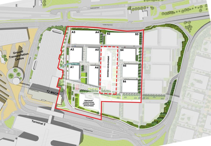

CONTENTS
EXECUTIVE SUMMARY 						1                                                  4.0     ECONOMIC CONTEXT 						15                                     APPENDIX A: LANDSCAPED PUBLIC REALM				36
                                                                           4.1     Conditions associated with Airport Development		         15
1.0     INTRODUCTION						3                                                4.1.1   Airport Development: Success Factors for Dublin Airport  15
1.1     Background to the Masterplan					3                                 4.2     Economic Opportunity associated with Airport Development 16
1.1.1   Fingal Development Plan 2011 - 2017:					                          4.2.1   Exports Profile                                          16
        Land Use Zoning and Local Objective 378			           3             4.2.2   Policy Approach for FDI Investment 				                  16
1.1.2   Adjacent Lands and Local Objective 379 			           3             4.2.3   Qualities that Attracts FDI Companies				16
1.1.3   Dublin Airport Local Area Plan 2006-2015 			3                      4.2.4   Recommendations from the Economic Analysis		             16
1.2     Time Horizon and Focus of the Masterplan 			         3
1.3     Purpose and Layout of the Masterplan 			             3             5.0     VISION AND PRINCIPLES 					17
1.4     Screening for Strategic Environmental Assessment and               5.1     Urban Design and Space Making Principles			 17
        Appropriate Assessment					3                                       5.1.1   Landside and Airside Connectivity				       17
                                                                           5.1.2   Delivery and Arrangement of Built Forms 			 17
2.0     PLANNING AND TRANSPORTATION POLICY CONTEXT                     6   5.1.3   Public Realm and the Green Lung				         17
2.1     National Planning and Transportation Policy Context		          6   5.2     Movement and Circulation Principles 				    18
2.1.1   National Spatial Strategy 2002-2020				                        6   5.3     Economic Principles						18
2.1.2   National Aviation Policy 2015					6                                5.4     Sustainability Principles 					18
2.1.3   Smarter Travel: A Sustainable Transport Future 2009-2020       6
2.1.4   Investing in our Transport Future: A Strategic Framework for       6.0     DEVELOPMENT STRATEGY 					19
        Investment in Land Transport, 2015				                         6   6.1     Specific Use Classes and Objectives               19
2.2     Regional Planning and Transportation Policy Context 		         7   6.2     Key Uses and Buildings 					                      25
2.2.1   Regional Planning Guidelines for the Greater Dublin                6.2.1   Former Aer Lingus Head Office Building (HOB)      25
        Area 2010-2022 						                                          7   6.2.2   Office Clusters                                   25
2.2.2   Draft Transport Strategy for the Greater Dublin Area 2016-2035 7   6.2.3   Building Design Guidance					26
2.3     Local Planning and Transportation Policy Context 		            7   6.3     Public Realm							28
2.3.1   Fingal Development Plan 2011-2017				                          7   6.3.1   Transition Square						28
2.3.2   Dublin Airport Local Area Plan 2006-2015 			9                      6.3.2   The Green Lung						28
2.3.3   Fingal/ North Dublin Transportation Study: Stage 2 Appraisal       6.3.3   Plazas								29
        Report 2015 							9                                               6.4     Mobility and Access 						29
                                                                           6.4.1   Mobility Strategy for Zone 1					                 29
3.0     EXISTING LANDS AND ENVIRONMENTAL CONTEXT 		          10            6.4.2   Transport Assessment 						29
3.1     Existing Lands at Dublin Airport and Environs 			    10            6.4.3   Parking Provision						30
3.1.1   Character Zones						10                                            6.4.4   Phasing of Parking						30
3.1.2   Existing Land Uses at Dublin Airport and Environs 		 10            6.4.5   Safeguarding a Transportation Corridor 			        30
3.1.3   Public Realm and Landscaping					10                                6.5     Utilities Provision 						30
3.2     Existing Mobility and Access 					                   11            6.5.1   Utilities Strategy 						30
3.2.1   Internal Road Network – Traffic Management           11            6.5.2   Power and Infrastructure Requirements 			         31
3.2.2   Public Transport – Local Stops and Service Routes		  11            6.5.3   Combined Heat Power (CHP) 					                   31
3.2.3   Pedestrian and Cycle Network 					                   11            6.5.4   Gas and Infrastructural Requirements 				         31
3.2.4   Car Parking Provision 						12                                     6.5.5   Information and Communications Technology (ICT)		 31
3.3     Existing Utilities Services					12                                 6.5.6   Water Supply and Infrastructural Requirements		   32
3.3.1   Water Supply 							12                                             6.5.7   Foul Water							32
3.3.2   Foul Water 							12                                               6.5.8   Surface Water 							32
3.3.3   Surface Water 							12                                            6.5.9   Flooding							32
3.3.4   Power Supply – Electricity and Gas 				              13            6.6     Environment and Heritage					32
3.3.5   Information and Communications Technology (ICT)		    13            6.7     Air Quality, Water Quality, Noise and Clmate			   33
3.4     Existing Environment and Heritage Context			         13
3.4.1   Biodiversity and Environment					13                                7.0     PHASING AND IMPLEMENTATION 				             34
3.4.2   Archaeology, Architectural and Cultural Heritage 		  14            7.1     Phasing and Implementation 					34
                                                                           7.1.1   Infrastructural Requirements 					34
                                                                           7.1.2   Development Scenario and Key Principles 			 34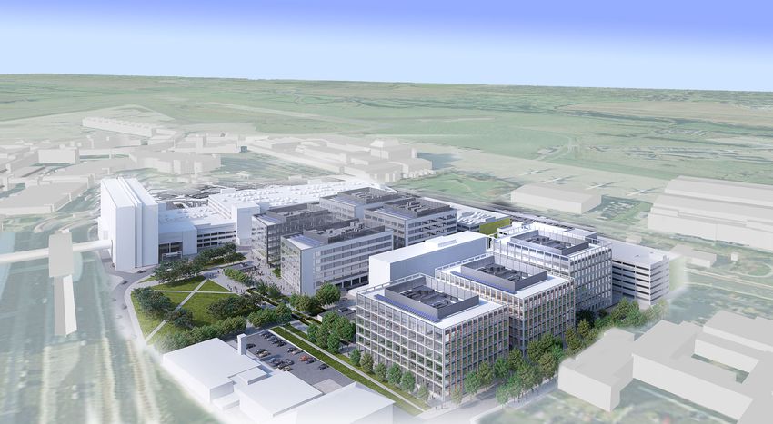
Dublin Airport Central Masterplan
EXECUTIVE SUMMARY Purpose of the Masterplan
The Masterplan will serve as a design framework for the future development
Development Strategy
The development strategy for the Masterplan is based on marrying the
Introduction of Phases 1 and 2 of Zone 1 of these strategically located lands. Economic requirements of the HT zoning and Local Objective 378, having regard to
Fingal County Council, in consultation with the Dublin Airport Authority analysis was undertaken to ensure that the framework would identify an restrictions on use classes associated with being within the Inner Noise Zone,
(DAA) and their consultancy team1, has prepared the Dublin Airport Central appropriate nature and scale for such development. Comparative studies optimising the strategic, well-connected nature of the lands, and harnessing
Masterplan. The Masterplan is a framework for the future development with other similarly sized airports internationally, indicated that Dublin the unique economic conditions associated with being in proximity to an
of lands strategically located adjacent to Dublin Airport. The Masterplan Airport is underperforming. international airport.
lands comprise two parcels of land, referred to as Zone 1 and Zone 2. The
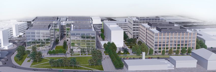
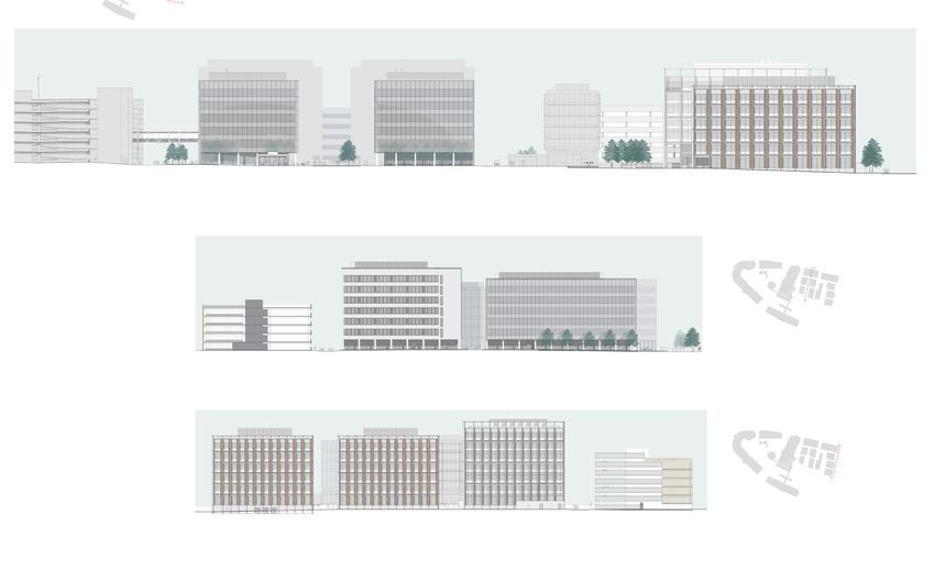
Masterplan specifically focuses on the development of Phases 1 and 2 of The nature and scale of development envisaged for the Masterplan lands The scale of office development and the type of potential tenants envisaged
Zone 1 for high quality, high value office accommodation supplemented is not intended to compete with other local or regional employment or for the Masterplan lands shall be unique to this Dublin Airport location. The
with ancillary uses. business locations, but with alternative international locations that would be Masterplan area has been identified as being most suitable for corporate
considered by companies that look to airport locations and proximities as type headquarters i.e. offices with floor spaces in excess of 1,000 sqm. This
being key factors in their location selection process. scale of office accommodation is permitted in principle under the HT land
Zoning and Local Objective
use zoning.
In the Fingal Development Plan 2011-2017, the Masterplan lands are zoned as
The delivery and implementation of the development framework for
‘HT’ High Technology and are subject to the map based Local Objective 378.
the lands will be achieved in a gradual manner, and will be linked to key Smaller offices with floor areas between 100 sqm and 1,000 sqm, while
The Zoning Objective for the HT zoning is to:
infrastructural requirements and services supports; including road network, permitted in principle in the HT land use zoning, will be open for consideration
Provide for office, research and development and high technology/ high
public transport and water services improvements. The provision of the within the Masterplan area as this scale of office is not as desirable at this
technology manufacturing type employment in a high quality built and
office buildings will be in coherent clusters with car parking, ancillary uses location due to the proposed larger building/ office block formats having the
landscaped environment.
and access to amenity opportunities. greater potential to attract corporate entities.
The map based Local Objective 378 specifically applies to these lands and
seeks to:
Offices that are less than 100 sqm, while permitted in principle under the
Consider within the context of the Masterplan, the nature and scale
HT zoning will generally not be permitted given the strategic location of the
of appropriate HT uses and enterprise centre related to aviation and
airport, issues regarding traffic generation and mobility management, and
airport business, research and development associated with airports
to ensure that the office accommodation provided in the Masterplan lands
or aviation and Air Transport Infrastructure, having regard to the site’s
does not compete with or impact negatively on other Fingal based HT zoning
strategic location within the Dublin Airport Authority Lands.
designations.
There are certain uses that are permitted in principle in the HT zoning
that are not be considered appropriate to the Masterplan lands due to the
610
considerations identified above. These use classes include high technology
manufacturing, hospital, and light industry. This approach is considered to
be consistent with the HT land use zoning and the move away from the DA
Dublin Airport
Central Masterplan
611 609 608
land use zoning that applies to the functional area of Dublin Airport.
Legend
Local Objective 378
Local Objective 379
Dublin Airport
606
Green Belt
Phasing and Implementation
607
High Technology
Open Space
The Masterplan serves as a design framework for the future development
General Employment
Road Proposal
of Phases 1 and 2 of Zone 1. It is, however, important to acknowledge that
612 605 Cycle/Pedestrian
¾
½
Proposed Metro Line
AIRPORT
on the basis of the transportation assessment undertaken to inform the
Inner Public Safety Zone
Outer Public Safety Zone
Masterplan, only Phase 1 and office floorspace up to a maximum of 41,677
Masterplan Area
&
378
&
379 Local Area Plans
Á
®
!
Metro Stop
Protected Structure
sqm is provided for within the context of this Masterplan. Development
of Phase 2 and additional floorspace above this level will be the subject of
72
» Monument
Zone 1: Site Layout Plan
¼
! Traveller Accomadation
&378 Local Objective further traffic assessment to be undertaken in the preparation of the Dublin
&
Airport Local Area Plan.
379 Local Objective
Key Guiding Principles
Planning Department, County Hall,
The Masterplan framework is formulated and structured on four key guiding Table 7.1 Zone 1: Phases 1 and 2 and Quantum of Office Development
principles. These include principles relating to urban design and quality space
Main Street, Swords
Phase Office Floor Space Cumulative Totals
Director of Services: Gilbert Power
Senior Planner: Rachel Kenny
making; movement and circulation; economic conditions; and environmental
Prepared By: P.Joyce Drawn By:C. Corrigan
in each Phase
Date: Feb 2015 Scale @ 1:7,500
602
and building sustainability.
Licence number 2015/24/CCMAlFingalCountyCouncil
Fingal Development Plan Zoning Map Extract
Phase 1 41,677 sqm 41,677 sqm
In combination, the principles guiding the development framework ensure Phase 2 33,787sqm 75,464 sqm
the creation of an extremely well connected, unique business destination
that is of a high quality design, construction and finish, that will offer a range
of high value office accommodation competing with other international
locations and supplementing the employment and enterprise opportunities
1
The team retained by the DAA comprises the following consultants: in Fingal.
KCAP Architects & Planners | McGarry Ní Éanaigh Architects | Atelier Dreiseitl | ARUP | Bannon
Property Consultants | Stephen Little & Associates | MauritsSchaafsma | Simon O’Donnell
1
Dublin Airport Central Masterplan
The provision of office development will be planned to coincide with
predicted demand levels as determined by the occupation of the completed
building forms and by specific infrastructural requirements particularly
those associated with the surrounding road network and water services
infrastructure. This process will be managed and monitored through the
development management process as planning applications for elements of
the scheme are assessed, and in consultation with key stakeholders.

Screening for SEA and AA
Ensuring best planning and environmental practice, the Masterplan has been
screened as part of the processes for Strategic Environmental Assessment
(SEA) and Appropriate Assessment (AA).

Consultants Brady Shipman Martin have undertaken the screening and
scoping processes for the SEA, and Scott Cawley Ltd have undertaken the
screening process for the AA. Fingal County Council has determined that
while the Masterplan did not require a full AA to be undertaken, a full SEA
was required. In this regard, an Environmental Report has been prepared
with the Masterplan and is published in conjunction with Masterplan.

    2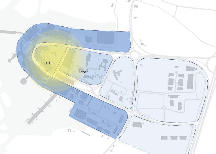
Dublin Airport Central Masterplan

1.0 INTRODUCTION                                                                    1.1.3 Dublin Airport Local Area Plan 2006-2015
                                                                                    The Masterplan lands are also included within the wider area subject to the
                                                                                                                                                                       1.4      Screening for Strategic Environmental Assessment
                                                                                                                                                                                and Appropriate Assessment
                                                                                    Dublin Airport Local Area Plan 2006-2015. The Local Area Plan (LAP) was            Notwithstanding that the Masterplan is a non-statutory plan, to ensure best
1.1     Background to the Masterplan                                                prepared in 2006, and prior to its expiration in 2012, the lifetime of the LAP     planning and environmental practice, the Masterplan has been screened
Fingal County Council, in consultation with the Dublin Airport Authority            was extended by three years up to June 2015. In the Dublin Airport LAP, the        as part of the processes for Strategic Environmental Assessment (SEA) and
(DAA) and their consultancy team2, has prepared the Dublin Airport                  Masterplan lands are zoned as ‘Core Aviation Development Zone’.                    Appropriate Assessment (AA).
Central Masterplan. The Masterplan comprises a framework for the future
development of lands located adjacent to Dublin Airport, covering an area           Through the adoption of the Development Plan in 2011, the HT zoning                Consultants Brady Shipman Martin have undertaken the screening and
of 21.7 hectares.                                                                   and map based Local Objective 378 applicable to the Masterplan lands               scoping processes for the SEA, and Scott Cawley Ltd have undertaken the
                                                                                    supersedes the zoning designation of the LAP. Importantly however, the             screening process for the AA. Fingal County Council has determined that
1.1.1 Fingal Development Plan 2011-2017:                                            overriding objectives and principles in the LAP and Development Plan               while the Masterplan did not require a full AA to be undertaken, a full SEA
      Land Use Zoning and Local Objective 378                                       continue to pertain to the future development of the Masterplan lands.             was required. In this regard, an Environmental Report has been prepared
                                                                                    Specifically, that the functionality of the aviation business of the airport       with the Masterplan and is published in conjunction with Masterplan.
The preparation of this Masterplan is determined by the current land use            shall be given priority in any future development framework and that the
zoning and objectives contained within the current Fingal Development Plan          nature and scale of potential commercial development shall be appropriate
2011-2017. In the Development Plan, the Masterplan lands are zoned as               to its location and where it positioning within the hierarchy of employment
‘HT’ High Technology and are subject to the map based Local Objective 378.          centres in the County.
The Zoning Objective for the HT zoning is to:
                                                                                    1.2     Time Horizon and Focus of the Masterplan
        Provide for office, research and development and high technology/ high      An exact length of time is not specified for life of the Masterplan. Instead
        technology manufacturing type employment in a high quality built and        a more pragmatic approach is envisaged, through which the delivery
        landscaped environment.                                                     and implementation of the development framework for the lands will be
                                                                                    achieved in a gradual manner. The development of the lands will be linked
The Objective is supported by the Vision for lands zoned as HT, which is to:        to key infrastructural requirements and services supports; including road
       Facilitate opportunities for high technology, high technology and            network, public transport and water services improvements. The provision
       advanced manufacturing, major office and research and development            of the office buildings will be in clusters with car parking, ancillary uses and
       based employment within high quality, highly accessible, campus style        access to amenity opportunities.
       settings. The HT zoning is aimed at providing a location for high end,
       high quality, value added businesses and corporate headquarters. An          The Masterplan lands that are subject to Local Objective 378 comprise
       emphasis on exemplar sustainable design and aesthetic quality will be        two parcels of land, separated by existing roadways. These areas of land
       promoted to enhance corporate image and identity.                            are referred to in the following Chapters of the Masterplan as Zone 1 (c.
                                                                                    9.5 hectares) and Zone 2 (c. 12.2 hectares). Due to the key infrastructural
The map based Local Objective 378 specifically applies to these lands and           requirements and the quantum of development ultimately envisaged,
seeks to:                                                                           the Masterplan focuses on the development framework of Zone 1 and, in
        Consider within the context of the Masterplan, the nature and scale         particular, on Phases 1 and 2 comprising an area of c. 5.89 hectares.
        of appropriate HT uses and enterprise centre related to aviation and
        airport business, research and development associated with airports         1.3     Purpose and Layout of the Masterplan
        or aviation and Air Transport Infrastructure, having regard to the site’s   The Masterplan will serve as a design framework for the future development
        strategic location within the Dublin Airport Authority Lands.               of Phases 1 and 2 of Zone 1 of these strategically located lands. Future
                                                                                    development shall be guided by Development Plan policy in relation to the
Chapters 6 and 7 of the Masterplan outline in detail the nature and scale,          requirements of the HT Zoning Objective, realising the Vision for HT zoned
respectively, of uses that are considered to be appropriate within the              lands, and complying with the stipulations of Local Objective 378.
Masterplan lands.                                                                   The layout of the Masterplan is organised into seven chapters: the initial
                                                                                    chapters present the context for the subject lands in relation to the planning
1.1.2 Adjacent Lands and Local Objective 379                                        policy; existing land uses and environmental conditions; and unique
There are lands located to the east of the regional road R132, measuring            economic factors pertaining to the lands. The subsequent chapters outline
approximately 8.77 hectares, which are subject to the map based Local               the vision and principles which guide the future development framework;
Objective 379 that seeks to:                                                        present the detailed development strategy for the Masterplan lands with
                                                                                    a focus on Phases 1 and 2 in Zone 1; and a description of the phasing and
        Undertake a Land Use and Transportation Study to determine the              implementation of the development framework for Zone 1.
        development capacity of the subject lands, and an appropriate phasing
        and quantum of development in advance of the operation of the Metro
        North line.

While this area of land is zoned as HT, is adjacent to the Masterplan lands and                                                                                         2 The team retained by the DAA comprises the following consultants: KCAP Architects &
is within the ownership of the DAA, it does not form part of this Masterplan                                                                                            Planners | McGarry Ní Éanaigh Architects | Atelier Dreiseitl | ARUP | Bannon Property Con-
                                                                                                                                                                        sultants | Stephen Little & Associates | Maurits Schaafsma | Simon O’Donnell
development framework.

                                                                                                                                                                                                                                                           3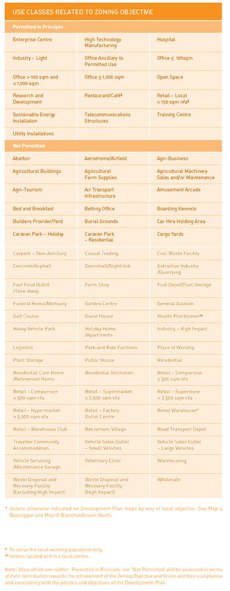
Dublin Airport Central Masterplan

                                                                                                        Dublin Airport
                                                                                                      Central Masterplan

                                                                                                Legend
                                                                                                              Local Objective 378
                                                                                                              Local Objective 379

                                                                                                  &378       Local Objective

                                                                                                  &379       Local Objective

                                                                      &
                                                                      378
                                                                            &
                                                                            379

                                                                                                   Planning Department, County Hall,
                                                                                                          Main Street, Swords
                                                                                                Director of Services:     Gilbert Power

                                                                                                Senior Planner:           Rachel Kenny

                                                                                                Prepared By: P.Joyce      Drawn By:C. Corrigan

                                                                                                Date: Feb 2015            Scale @   1:16,029

                                                                                                Licence number 2015/24/CCMAlFingalCountyCouncil

    Aerial Photo with lands subject to Local Objectives 378 and 379
4
Dublin Airport Central Masterplan
610
Dublin Airport
Central Masterplan
611 609 608
Legend
Local Objective 378
Local Objective 379
Dublin Airport
606
Green Belt
607
High Technology
Open Space
General Employment
Road Proposal
612 605 Cycle/Pedestrian
¾
½
Proposed Metro Line
AIRPORT
Inner Public Safety Zone
Outer Public Safety Zone
Masterplan Area
&
378
&
379 Local Area Plans
Á
® Metro Stop
! 72 Protected Structure
» Monument
¼
! Traveller Accomadation
&378 Local Objective
&379 Local Objective
Planning Department, County Hall,
Main Street, Swords
Director of Services: Gilbert Power
Senior Planner: Rachel Kenny
Prepared By: P.Joyce Drawn By:C. Corrigan
Date: Feb 2015 Scale @ 1:7,500
602
Licence number 2015/24/CCMAlFingalCountyCouncil
Fingal Development Plan Zoning Map Extract
01
5Dublin Airport Central Masterplan
2.0 PLANNING AND At a regional focus, the NSS highlights that the continuing health of the
Dublin area is critically dependent on creating an efficient and high quality
Of the three State airports, the DTTAS highlights their critical role in
supporting economic development by facilitating trade, tourism and inward
TRANSPORTATION
system of public transport connections within the GDA to improve access investment. The Policy highlights that the country’s airports have access
to employment, education, services and amenities, and also to ensure good to a well-developed network of regional and national development bodies
international access particularly through Dublin Airport and Dublin Port. with mandates to promote the development of the regions. The availability
POLICY CONTEXT of land with investment/ development potential within and around the
country’s airports presents possibilities for the creation of new business
activities to underpin the core airport business.
The statutory planning and transportation policy context for the Masterplan
is determined at the national, regional and local policy levels. The key The Policy highlights that while access to global hubs is of key importance
planning policy documents guiding the development framework contained to inward investment, Dublin Airport‘s development as an interconnecting
in the Masterplan includes the National Spatial Strategy 2002-2020, the hub is itself also of great importance to the Irish aviation sector and the
Regional Planning Guidelines for the Greater Dublin Area 2010-2022, and broader economy. The Policy concludes with commitments to support the
the Fingal Development Plan 2011-2017. development of Ireland‘s airports, including the development and promotion
of Dublin Airport as a European Secondary Hub Airport.
Importantly, due to the strategic location of the Masterplan lands adjacent
to Dublin Airport, a key international gateway with a high level of landside 2.1.3 Smarter Travel: A Sustainable Transport Future 2009-2020
intermodality, regard has also been given to the policy context established In 2009, the Department of Transportation, Tourism and Sport (DTTAS)
by key transportation documents. These documents include the National published Smarter Travel: A Sustainable Transport Future 2009-2020.
Aviation Policy 2015; Smarter Travel: A Sustainable Transport Future 2009; Through the report, the Government seeks to establish a new approach to
Investing in our Future, 2015, the Draft Transportation Strategy for the national transportation policy by identifying existing unsustainable patterns
Greater Dublin Area 2016-2035, and the Fingal/ North Dublin Transport of travel, most particularly the reliance on the private car, and promoting
Study: Stage 2 Appraisal Report 2015. more sustainable solutions. To address the existing patterns and achieve a
greater level of sustainability, the report recommends changes in personal
2.1 National Planning and Transportation Policy Context behaviour, in public policy in relation to settlement patterns and continued
2.1.1 National Spatial Strategy 2002-2020 investment in public transport.
The National Spatial Strategy 2002-2020 (NSS) outlines the planned spatial
development for the country until 2020. The strategy presents overarching Of relevance to the development framework envisaged in the Masterplan,
aims at a national level, with more detailed development strategies for the report recommends a number of actions including those relating to
addressing conditions specific to each region. In relation to Dublin Airport focusing population growth in areas of employment and to encourage
located in the Greater Dublin Area (GDA), the focus of the NSS is primarily people to live in close proximity to places of employment; and actions aimed
on it being an international gateway into the country, as a vital centre in the at ensuring that alternatives to the private car are more widely available,
national transportation network and as an entity at which connections, both mainly through a radically improved public transport service and through
transport and economic, are created. investment in cycling and walking.
Strategically, the NSS proposes that the spatial structure for development 2.1.4 Investing in our Transport Future: A Strategic Framework
across the country must be supported by a national transport framework. for Investment in Land Transport, 2015
This framework will comprise of an improved network of roads and public In April 2015, the Department of Transportation, Tourism and Sport
transport services that will enhance access and connections throughout the (DTTAS) published Investing in Investing in our Transport Future: A Strategic
country. The NSS intends for this framework to be internationally connected Framework for Investment in Land Transport. This document seeks to
through vital centres such as airports, with Dublin Airport to the fore, and determine the optimal strategy for the development and management of
ports. Ireland’s land transport network over the coming decades.
The NSS notes that Dublin Airport serves the city, region and country and In the accompanying Final Steering Group Report, key priorities for and
offers the greatest number of international connections. For Ireland to principles to frame transport investment are set out. In relation to Dublin
have a globally competitive but regionally integrated economy, effective Airport, the Report highlights that the airport is fundamental to providing
connections to the world are vital. The NSS guides that expanding the good international access both for passengers and freight (in 2011, 79% of
level of services available from Dublin Airport to an increasingly wider all passengers into and out of Ireland and 85% of air freight went through
range of destinations is essential in the interests of underpinning Ireland’s Dublin Airport). The Report refers to a study on future aviation demand
future international competitiveness. The national and regional benefits of growth which suggests a doubling of aviation demand by 2050. The
Map 5 Dublin and Mid East Regions, National Spatial Strategy
expanded services from Dublin Airport can be enhanced through improved Report suggests that such significant demand growth will manifestly have
connections with public transport network, the national roads network and implications for land transport provision to the country’s airports and for the
the regional airports. The NSS stated position is to ensure Ireland remains
2.1.2 National Aviation Policy, 2015
The Department of Transportation, Tourism and Sport (DTTAS) published need for the balance to be struck between private car and public transport
effectively linked to international markets and priorities in this regard include access to them. This, the Report notes, is particularly in the case of Dublin
its National Aviation Policy in August 2015. The DTTAS Policy document has
enhancing the role of Dublin, Cork and Shannon airports as international Airport, where increased demand levels over time should positively impact
three key goals: to enhance Ireland’s connectivity; to grow and support the
airports through efficient terminal facilities and effective land-side access by on the potential to deliver value for money investment in public transport
aviation sector in Ireland; and to maximise the aviation sector’s contribution
road and public transport. options.
to the country’s economic growth and development.
6Dublin Airport Central Masterplan
2.2 Regional Planning and Transportation Policy Context The Fingal/ North Dublin Transportation Study (see Section 2.3.3 below) As the Masterplan is being prepared in the context of the current Development
2.2.1 Regional Planning Guidelines for the Greater Dublin Area tasked with identifying the optimum longterm public transport solution Plan, it is required to comply with the policies and objectives contained in
2010-2022 to connect Dublin City Centre, Dublin Airport and Swords identified an the Plan. Of particular relevance for the Masterplan, are the stated policy
The Regional Planning Guidelines for the Greater Dublin Area 2010-2022 Optimised Metro North as being the best solution. Subsequently, Metro requirements relating to the operation of Dublin Airport, the ‘HT’ High
(RPG) expand on the proposed spatial structure contained in the NSS. As North was included in the Government’s Capital Investment Plan 2016- Technology land use zoning, Green Infrastructure, and Transportation policy
with the NSS, the RPG focus on Dublin Airport’s role as a vital point in the 2021. It will run from St Stephen’s Green via the Airport to Swords. The for the County.
region’s transportation network, additionally however are more detailed exact location of the Metro stop for the Airport is likely to be at the Ground
policies recognising and supporting the airport as a driver of economic Transportation Centre (GTC), just north of Terminal 2. Policy relating to Dublin Airport
development in and for the region. The Development Plan highlights both the international and national
2.3 Local Planning and Transportation Policy Context importance of Dublin Airport in the country’s transportation network, but
The RPG refers to the key nodes within the region’s transportation network, 2.3.1 Fingal Development Plan 2011-2017 also its paramount significance as an economic entity in Fingal and the
including the international standing of Dublin Airport. The RPG state that As outlined in Chapter 1, the planning context for the preparation of this region, and its ability to drive economic development and generate direct
despite significant investment in the region’s transport system, there Masterplan emanates from the current Fingal Development Plan 2011- and indirect forms of employment.
continue to be impediments such as road congestion and long travel times, 2017. In the Development Plan, the Masterplan lands are zoned as ‘HT’ High
and the need for greater integration of public transport services. The Technology and are subject to the map based Local Objective 378, which The Development Plan contains broad objectives relating to the development,
RPG raise that an efficiently functioning, well connected airport is a key commits the Council to: operation, and management of Dublin Airport and its surrounding environs.
competitiveness factor for Dublin, the wider region and the state, and that Consider within the context of the Masterplan, the nature and scale The Plan contains objectives in the following areas: strategic operational
an area requiring ongoing attention is the airport’s connections to the city of appropriate HT uses and enterprise centre related to aviation and issues, runway and terminal facilities; noise controls and abatement
and the region with public transport connections to the airport requiring airport business, research and development associated with airports measures; safety standards and provisions; air and water quality standards
significant development. or aviation and Air Transport Infrastructure, having regard to the site’s and provisions; best practice measures for building design quality and
strategic location within the Dublin Airport Authority Lands. accessibility; optimising surrounding land uses; controls and measures
In relation to economic connections, the RPG state that identifying priority relating to residential development.
targets for investment in transport infrastructure at locations which can FOSTERSTOWN
support economic and critical mass, and support structures and ease of
access to do business is essential to the economic success of the region. 636 632
630
Additionally, the RPG support and promote the role of the GDA as an
attractive international destination for business, that the identified strategic Dublin Airport
Central Masterplan
economic growth centres continue to be focal points for regional population
Legend
growth and employment. To this end, the ‘critical mass’ concept should
insert zoning for this area
be employed whereby development density levels are such to justify first 631
class and strategic infrastructure provisions and to take full advantage of 629
&378 Local Objective
international transport hubs such as Dublin Airport and Dublin Port. 627
&379 Local Objective
Subject Lands B
The stated policy in the RPG for Dublin Airport is ER7 which seeks to: 610 Subject Lands A
Promote and support the role of Dublin Airport as the primary gateway to
Ireland and the GDA and as an important employment hub and business 626 628
611 609 608
location in the region through land use planning which facilitates future 606
airport capacity needs and by improved transport linkages to the city
607
624
625
and region. 612
AIRPORT
2.2.2 Draft Transport Strategy for the Greater Dublin Area &
378
&
379
2016-2035
In October 2015, the NTA published the Transport Strategy the Greater
Dublin Area 2016-2035 in draft form. The draft Strategy seeks to establish
the essential transportation policies and measures required to support the
GDA in meeting its full potential.
602
The draft Strategy highlights the role of Dublin Airport as an international
gateway, its critical national and regional importance, and how the SILLOGE
604
management of transport to and from the airport must be considered to CP
ensure its efficient operation. The Strategy identifies that ‘Protecting and MERRYFALLS
DARDISTOWN
enhancing access to the ports and Dublin Airport is a strategic priority’
Planning Department, County Hall,
616 Main Street, Swords
617
as congestion currently presents the greatest risk to its functionality. It
Director of Services: Gilbert Power
621
Senior Planner: Rachel Kenny
acknowledges that ‘serving Dublin Airport with a high-capacity, reliable and Prepared By: P.Joyce
Date: Feb 2015
Drawn By:C. Corrigan
Scale @ 1:18,033
frequent public transport service to Dublin City Centre and improved public Licence number 2015/24/CCMAlFingalCountyCouncil
transport network connectivity at a national level is, therefore, a priority for
DA zoning from Development Plan showing Inner and Outer Noise and Public Safety Zones
the transport strategy’.
7Dublin Airport Central Masterplan
The Development Plan contains a specific ‘DA’ Dublin Airport zoning Additionally, Objective EE30 seeks to: by transportation policy at national level, emphasises improvements to
objective covering an extensive area at and surrounding the airport. The Encourage the development of corporate offices and knowledge based the physical transportation infrastructure including rail and bus routes,
Zoning Objective for the DA zoning is to: enterprise in the County on HT zoned lands and work with Government increasing reliance on sustainable forms of transport including public
agencies, and other sectors to achieve such development. transport, cycling and walking, and encouraging modal change from the
Ensure the efficient and effective operation and development of the dominant use of the private car to these alternative modes.
airport in accordance with the adopted Dublin Airport Local Area Plan. As the HT zoning forms the basis for the development framework of the
The Objective is accompanied by the Vision for lands zoned as DA, which is Masterplan, the strategic vision for HT zoned lands will be encapsulated
to: within the Masterplan and be among its guiding principles, as will The Masterplan lands are strategically located adjacent to Dublin Airport
Facilitate air transport infrastructure and airport related activity/uses mechanisms through which the Masterplan can comply with and contribute which, as outlined in greater detail in Chapter 3, is a location that is extremely
only (i.e. those uses that need to be located at or near the airport). All to the achievement of the HT vision. well connected and served by a range of existing modes of transport,
development within the Airport Area (as designated by the Dublin Airport including the public road network and most particularly public and private
Local Area Plan) should be of a high standard reflecting the status of an Green Infrastructure Policy bus services. Evidently, the Masterplan lands are uniquely positioned to
international airport and its role as a gateway to the country and region. The Fingal Development Plan 2011-2017 presents the concept of ‘Green maximise on these existing transport services and infrastructure.
Minor extensions or alterations to existing properties located within the Infrastructure’ and proposals for developing a Green Infrastructure Strategy
Airport Area which are not essential to the operational efficiency and for the County through planning policy related to Local Area Plans and Aviation Related Designations
amenity of the airport may be permitted, where it can be demonstrated development proposals. There are important aviation related designations for noise and public
that these works will not result in material intensification of land use. safety that are associated with the operation of the airport and apply to the
Air Transport Infrastructure includes: aircraft areas, air traffic control/ Green Infrastructure is an encompassing term for the interconnected Masterplan lands. These designations are the Inner and Outer Noise Zones
tower, ancillary health, safety and security uses, aprons, cargo handling, networks of land and water that sustain environmental quality and enrich and the Inner and Outer Public Safety Zones. These arise from European
maintenance hangers, meteorology, retail – airside/duty free, runways, our quality of life. This infrastructure comprises nature conservation areas, and national policy and legislation, and have been subsumed into local
taxiways, terminals and piers. parks, open space, rivers, floodplains, woodlands, farmland, and coastal planning policy.
zones which surround and weave through our urban areas. This vital
This DA zoning objective applies to the vast majority of lands surrounding the infrastructure allows space for nature, biodiversity and natural systems, The designations are indicated on the Fingal Development Plan 2011-2017
HT zoned Masterplan site. Fingal County Council is committed to facilitating and provides numerous health and environmental benefits, and social and zoning maps and the relevant policy is included within the written statement.
future growth and development at the airport whilst safeguarding the recreational opportunities for people. The Masterplan lands are located within the Inner Airport Noise Zone,
surrounding environment and communities. outside of the Inner Public Safety Zone and partially within the Outer Public
The aim of the Development Plan in relation to Green Infrastructure is to: Safety Zone (northwest corner of Zone 1 and southeast corner of Zone 2).
Land Use Zoning Objective ‘HT’ High Technology Create an integrated and coherent green infrastructure for the County (See DA Zoning from Development Plan showing the Inner and Outer Noise
There are four key employment and enterprise generating land use zonings which will protect and enhance biodiversity, provide for accessible parks and Public Safety Zones.)
designated in the Development Plan: ‘GE’ General Employment, ‘HI’ Heavy and open space, maintain and enhance landscape character including
Industry, ‘ME’ Metro Economic Corridor and ‘HT’ High Technology. These historic landscape character, protect and enhance architectural and The creation of Noise Zones at Dublin Airport arises from compliance with
zonings have varying Objectives and Visions depending on the type archaeological heritage and provide for sustainable water management national legislation and the EU Directive on Environmental Noise. The
of enterprise and industry to be attracted and facilitated, the form of by requiring the retention of substantial networks of green space in Development Plan policy for the Noise Zones is to restrict inappropriate
employment to be generated, localised advantages to be maximised upon, urban, urban fringe and adjacent countryside areas to serve the needs development within the Outer Noise Zone and to actively resist noise-sensitive
and potential opportunities to be harnessed. of communities now and in the future including the need to adapt to uses within the Inner Noise Zone. As required in the noise legislation, the
climate change. four Dublin planning authorities have prepared The Dublin Agglomeration:
Of these employment based land uses, the HT zoning is targeted towards Environmental Noise Action Plan 2013-2018, which includes analysis of
the provision of high value, high quality office accommodation and The principles that form the basis of the Green Infrastructure concept Dublin Airport, identified as a major airport. The Action Plan reiterates the
manufacturing space located within easily accessible locations in quality serve as guiding principles for the development proposals contained in the stated policy in the Development Plan for the two zones. The Action Plan
designed environments. Masterplan. Key elements of the development framework, as presented in specifies noise sensitive receptors to be residential developments, hospitals
Chapter 5, are a focus on the public realm and the creation of the ‘Green including nursing and convalescence homes, educational institutions,
Specifically, the HT Zoning Objective seeks to: Lung’. The Green Lung is an interlinked system of high quality landscaped childcare/ crèche facilities, and places of worship.
Provide for office, research and development and high technology/ high open spaces running along a west-east orientation through the Masterplan
technology manufacturing type employment in a high quality built and lands. The design and delivery of the Green Lung seeks to accord with While in relation to the Public Safety Zones, the Development Plan policy
landscaped environment. wider Development Plan policy relating to Green Infrastructure. is guided by a report prepared by consultants Environmental Resources
Management in 2005 for the Department of the Environment on the topic.
The Vision for the zoning further defines the planning principles which guide Transportation Policy While this report has not been formally adopted as Government policy to
potential development in such zonings as to: A fundamental component of the Masterplan framework, is complying with date, guidance is provided on the potential use and scale of development
Facilitate opportunities for high technology, high technology and Development Plan transportation policy planned for the County. The Plan’s that may be considered appropriate within these Zones. Applicable to
advanced manufacturing, major office and research and development Statement of Policy in this regard seeks to: the Masterplan lands, is the guidance relating to the Outer Public Safety
based employment within high quality, highly accessible campus style Promote and facilitate movement within, and to, the County of Fingal, Zones. Within the Outer Public Safety Zones, residential, retail/ leisure and
settings. The HT zoning is aimed at providing a location for high end, by integrating land use with a high quality, sustainable transport system employment uses are permissible in principle subject to restrictions in terms
high quality, value added businesses and corporate headquarters. An that prioritises public transport, cycling and walking. In facilitating such of quantums (density per hectare).
emphasis on exemplar sustainable design and aesthetic quality will be movement, the natural and cultural heritage of the County must be
promoted to enhance corporate image and identity. protected. 2.3.2 Dublin Airport Local Area Plan 2006-2015
In 2006, Fingal County Council prepared the Dublin Airport Local Area Plan
The Development Plan policy on transportation, significantly determined (LAP). In 2012, the lifetime of the LAP was extended by a further three
8Dublin Airport Central Masterplan
years up to June 2015. The LAP covered an extensive area of some 1,084 related economic activities, and where permissible, non-aviation commercial As the 2006 LAP has expired, Fingal County Council intends to prepare a new
hectares including all functional and operational facilities at the airport, and development would be limited in quantum, specific in location and phased to LAP for the airport and all associated lands.
lands extending eastwards beyond the regional road R132 and up to the M1 coincide with the delivery of the Metro and other additional public transport
motorway. facilities. Through the adoption of the Fingal Development Plan 2011-2017, 2.3.3 Fingal/ North Dublin Transportation Study: Stage 2
these applicable policies have been superseded by the provisions of the ‘HT’ Appraisal Report 2015
The LAP is a detailed planning framework comprising information on the zoning and of Local Objective 378 which establish the Masterplan as the In June 2015 the NTA published the Fingal/ North Dublin Transport Study:
historical development of the airport; an overview of the-then existing framework in which to determine the appropriate nature and quantum of Stage 2 Appraisal Report. The Study is a key framework for the local planning
conditions at the airport; and policies and objectives relating to airport development. and transportation policy context of the Masterplan lands. The purpose
infrastructure, aircraft operations, surface access, drainage and utilities, of the overall Study is to identify the optimum longterm public transport
heritage, design criteria, commercial development and implementation. The LAP set the policy context for a number of infrastructural developments solution to connect Dublin City Centre, Dublin Airport and Swords.
at Dublin Airport which have been undertaken such as the extension and
In the LAP, the Masterplan lands were zoned as ‘Core Aviation Development improvements to Terminal 1; the development of Terminal 2, Pier D (also The Stage 2 Appraisal Report further develops and assesses the potential
Zone’ and subject to policies relating to commercial development at the referred to as Pier 4) and the associated multi-storey car park; and the options identified in the previous Stage 1: Appraisal Report from 2014.
airport. In the LAP, commercial development is largely restricted to airport upgrade of the R132 to dual carriage way status. The Stage 2 Report found that the key transport infrastructure priority for
Fingal/ North Dublin is the provision of new public transport capacity for the
corridor from Dublin City Centre, through the north inner city and Ballymun
to Dublin Airport and Swords. The selected public transport option is
referred to as LR7 (Optimised Metro North) and is identified as representing
the best medium and long term public transport solution for the Greater
Dublin Area.
Dublin Airport
LOCAL AREA PLAN
Map No.1
Proposed Zoning
LEGEND
Planning Department,
County Hall, Main Street, Swords.
Director of Services: David O’Connor
Senior Planner: Seán Ó Faircheallaigh
Scale: 1:18,000 @ A3 Prepared By: E.B.
Date: June 2006 Drawn By: S.G. / A.C.
Includes Ordnance Survey Ireland data reproduced under OSi Licence
number 2003/07/CCMA/Fingal County Council.
Unauthorised reproduction infringes Ordnance Survey Ireland and
Government of Ireland copyright. © Ordnance Survey Ireland, 2006.
Dublin Airport LAP zoning land use
9Dublin Airport Central Masterplan
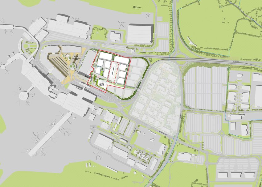
3.0 EXISTING LANDS The Masterplan lands are centrally positioned within a larger area referred
to as the Horseshoe, so-called due to its spatial composition. The Horseshoe
AND ENVIRONMENTAL
Ring Zone is an outer perimeter essentially forming Dublin Airport and
defining the airside2-landside3 interface. The Horseshoe Ring comprises a
range of buildings that have evolved over a number of decades, the majority
CONTEXT of which are associated with the functional operations of the airport including
the Old Central Terminal Building, Terminal 1 and Terminal 2, associated
Pier structures, aircraft hangers, and apron4 area.
This Chapter presents the physical, infrastructural and environmental
context associated with the Masterplan lands. There are descriptions of The Inner Horseshoe Zone is formed by three parcels of land separated by
Dublin Airport and its environs, which includes the lands comprising the the existing road system: to the west, adjacent to the bend in the Horseshoe
Masterplan area. The current infrastructural context is outlined with regard Ring is the Ground Transportation Centre (GTC); centrally positioned is an
to mobility, water services and utilities. Finally, the environmental and area referred to as Zone 1; while to the east of Zone 1 are lands referred to Terminal
heritage context of the Masterplan lands are presented. as Zone 2. Parking Structure
Large Scale Business
3.1 Existing Lands at Dublin Airport and Environs In relation to the Character Zones, the Masterplan lands comprise Zone 1 Office
The Masterplan lands are strategically located adjacent to Dublin Airport. (excluding the existing multi-storey car park associated with Terminal 2) and Hospitality
The immediate proximity of the lands to the airport contributes to their Zone 2 of the Inner Horseshoe Zone. The boundaries of the Masterplan Commercial
unique character and setting, and any analysis and assessment of the lands lands are formed by the internal and external road network, most notable Logistics
is required to refer to this major transportation hub. of which is the R132 which serves as a strong eastern boundary to the Cultural
Masterplan lands. Residential
Dublin Airport, for the purposes of this section, refers to the complex of Leisure
buildings forming the airport within which the operational functions of the 3.1.2 Existing Land Uses at Dublin Airport and Environs Technical
airport occur. Principally, these are the terminal buildings, piers, hangars There is a notable mix and range of use classes at Dublin Airport and its
and car park buildings. References to the airport’s environs are to the lands Uses
environs. In addition to the dominant operational airport use, a number
immediately adjacent to and surrounding Dublin Airport, and include the of associated and ancillary uses have become established. These include
full extent of the Masterplan lands. commercial car parking, offices, logistics, industrial, aviation related business 3.1.3 Public Realm and Landscaping
operations, and hospitality and leisure related uses. The existing public realm at Dublin Airport and its environs is characterised
3.1.1 Character Zones by its functional use, such as access, parking with in-between green spaces,
Dublin Airport and environs are categorised into a number of distinct The GTC functions as the natural centre of gravity of the airport, operating as resulting in an overall impression of hard surfaces. Positively, there are
‘Character Zones’ based on the function of the zone and the nature and the key public transport focal point for bus trips associated with numerous some notable developed and maintained stands of tree planting which do
scale of the buildings located therein. The zones characterised are the public and private bus operators. In addition to set-down and pick-up areas provide visual and environmental benefits.
Horseshoe Ring, the Ground Transportation Centre, the Inner Horseshoe and surface car parking, the GTC comprises a number of key buildings
Zone and Future Development Zone. including the Terminal 1 multi-storey car park and the airport church, Our
Lady Queen of Heaven.
Zone 1 contains a number of distinguishable buildings including the former
Aer Lingus Head Office Building (HOB), the multi-storey car park associated
with Terminal 2, the Maldron Hotel and the ALSAA swimming pool. The most
notable building within Zone 2 is the Radisson Hotel. Across Zones 1 and
2, the existing buildings vary in scale and composition so that a coherent
design rationale is not clearly identifiable. Between the two hotels and the
terminal buildings is a mixture of non-descript, low-rise buildings of various
uses including office, logistics and industrial. Lastly, the Future Development
Zone includes lands to the east of regional road R132 that, at present,
operate as a commercial car park.
This current range of use classes at the airport indicates the synergies
that can exist between an airport, commercial operations and supportive
ancillary uses.
Existing Quality Green Space
Horseshoe Ring 2
Airside is the area within an airport complex which requires Customs and Security clearance
Inner Horseshoe Zones to access. Quality Green Structures
Future Development Zones
3
Landside is the area(s) at an airport before passengers go through Security, Customs, and
Immigration.
Ground Transportation Centre 4
Apron is the area of an airport where aircraft are parked, boarded, loaded, unloaded, and
Character Zones refuelled.
10Dublin Airport Central Masterplan
The topography of the Dublin Airport area is considered as generally flat to 3.2.3 Pedestrian and Cycle Network
gently sloping. The ground level rises in a westerly direction from a lower The existing provision of footpath facilities is generally good within Dublin
point of 55m OD at the R132 to a peak of 67.5m OD at Terminal 1. The rise Airport and its environs. The existing footpaths being of sufficient width
in ground level from the public road up to the operational complex of the and pavement surface quality. Covered walkways and dedicated footpaths
airport, results in structures being visually prominent, and for buildings such have been provided to encourage walking within the airport grounds and
as Terminal 2 having a particularly strong visual impact. Corballis
Road North provide connection between terminals, public transport nodes, car parking
spaces and offices. Dedicated signalised pedestrian crossing locations are
ad
Ro
ad
provided at all the major road crossing points. Other busy pedestrian-
CP
nk Ro
nk
M1 Link Road
ue
MS
Li
en
ST
vehicle interaction points are designated as zebra crossings with provision
T1
st Li
s Av
st
T2
ad
Corbal
We
ST
lis Dr
ro
ive
alli
MS
Te
Old we
of dropped kerbs along the primary pedestrian desired lines. The recent
CP
rm
nk
in
Corb
Li
al
upgrade to the internal road system within the airport included a significant
st
1
Ea
investment in cycle facilities particularly on the approach routes into the
Road
Te
y
rm
Wa
ina
l
67.5 2
s
airport from the R132. The cycle facilities serve both the terminal buildings
R132 Swords
65 60 50
li
45
al
55
rb
and also many of the employment centres located through the airport
Co
Co
rb
a ll
is
Terminal 1 Arrivals Ro
ad
So
ut and environs. The R132 has recently been upgraded and the works have
h
Terminal 1 Departures
included improvements to the cycling environment along the road.
Terminal 2 Arrivals
Terminal 2 Departures
ST MSCP/Bus Routes
Horseshoe Entry Route
Horseshoe Exit Route
Local Road Network
3.2.2 Public Transport – Local Stops and Service Routes
Dublin Airport is served by three main bus stop locations; outside Terminal
1, outside Terminal 2 and within the Ground Transportation Centre (GTC).
The bus stops located outside Terminal 1 and 2 are used by Aircoach and
Route 747 (Airlink), though all buses may set down here. Route 747 (Airlink)
Topography provides premium access to Dublin City centre including many of the major
hotels located in the city via the Port Tunnel. Aircoach provides a range of
3.2 Existing Mobility and Access bus services both locally within Dublin City centre and nationally to regional
3.2.1 Internal Road Network – Traffic Management cities and towns. The GTC provides bus stops for the long-term car parks,
The existing airport internal road network consists primarily of a one-way for Bus Éireann services which are routed through the airport and other
system travelling in a clockwise direction. The one-way system splits at the Dublin Bus services. In addition, a coach parking area is provided within the Pedestrian Network
main internal junction with Corballis Road South with the southern route GTC serving other chartered coach services with an overflow also located in
serving Terminal 1 and its multi-storey car park, and the northern route the DAA owned long term car park to the east of the R132. Pedestrian Network
serving Terminal 2 and its car park. The one-way system provides access to
Zone 1 and Zone 2 of the Masterplan lands.
Corballis Road South is a two-way road and joins the internal road network
at the signalised junction. This roadway provides access to Zone 1. On the
East Link Road there are diverge lanes serving the Radisson Hotel/ Cloghran
House and the Maldron Hotel/ former Aer Lingus HOB.
Bus Circulation
Taxi Circulation
City Bus Stop
Regional Bus Stop
Taxi Stand
Public Transport
11You can also read