Lower Waikato Zone Plan - 31 July 2018 Final for Adoption - Waikato Civil Defence
←
→
Page content transcription
If your browser does not render page correctly, please read the page content below
Lower Waikato Zone Plan

                   31 July 2018

                 Final for Adoption

Doc #11815952                         Page 1
Approved for release by Greg Ryan, Manager – Business and Technical Services (3rd August 2018)

Prepared by:

Sarah Lealand – Lower Waikato Zone Manager

Rebecca Hare, Michelle Archer, Angus McKenzie – Place Group Limited

For:

Waikato Regional Council

Private Bag 3038

Waikato Mail Centre

Hamilton 3240

Acknowledgments:

Lower Waikato Catchment Committee members (Councillors, community and iwi members)

Integrated Catchment Management Directorate (River and Catchment Services, Natural Heritage Services,
Land Management Advisory Services, Biosecurity and Regional Hazard teams)

Science and Strategy Directorate (Water, Coastal, Land and Soil, Policy and Infrastructure teams)

Communications Team

Waikato River Authority Keri Neilson

Disclaimer

This zone plan has been prepared for the use of the Waikato Regional Council as a strategic, non-statutory, document.

Council requests that if excerpts or inferences are drawn from this document for further use by individuals or
organisations, due care should be taken to ensure that the appropriate context has been preserved, and is accurately
reflected and referenced in any subsequent spoken or written communications.

While Waikato Regional Council has exercised all reasonable skill and care in controlling the contents of this report,
Council accepts no liability in contract, tort or otherwise, for any loss, damage, injury or expense (whether direct, indirect
or consequential) arising out of the provision of this information or its use by you or any other party.

Doc #11815952                                                                                              Page 2
CONTENTS
EXECUTIVE SUMMARY                                                                                    5
1      INTRODUCTION                                                                                  6
     1.1   PURPOSE                                                                                   7
     1.2   STRATEGIC FIT                                                                             7
     1.3   SCOPE AND SERVICES                                                                        8
2.     LOWER WAIKATO ZONE DESCRIPTION                                                               13
     2.1   ZONE OVERVIEW                                                                            13
     2.2   CULTURAL HERITAGE                                                                        15
     2.3   KEY FEATURES                                                                             15
       2.3.1    The Waikato River                                                                   15
       2.3.2    Floodplains and associated flood control scheme infrastructure                      15
       2.3.3    Water Supply Sources & Infrastructure                                               17
       2.3.4    Regional and National Infrastructure                                                18
       2.3.5    Land Cover and Land Use                                                             19
       2.3.6    Geology                                                                             20
       2.3.7    Topography and Landforms                                                            22
       2.3.8    Peat soils                                                                          22
       2.3.9    Wetlands and Forests                                                                23
       2.3.10   Shallow Lakes                                                                       23
       2.3.11   Port Waikato and estuarine environment                                              24
       2.3.12   Coastal Marine Area                                                                 24
3.     LEGISLATIVE AND POLICY FRAMEWORK                                                             25
     3.1   LEGISLATION AND STATUTORY PLANS                                                          25
     3.2   KEY NON-STATUTORY POLICIES AND PLANS                                                     28
4.     KEY MATTERS FOR THE ZONE                                                                     34
     4.1 THE FLOOD SCHEME AND SIGNIFICANT INFRASTRUCTURE ISSUES                                     34
       4.1.1 The Flood Scheme and Natural Hazard Risks                                              34
       4.1.2 The Flood Scheme and Flood Risks                                                       35
       4.1.3 The Flood Scheme, Climate Change and Development Pressure                              38
       4.1.4 The Flood Scheme and Aging Assets                                                      38
       4.1.5 The Flood Scheme and Peat Subsidence                                                   38
       4.1.6 The Flood Scheme and Increasing Environmental & Regulatory Performance Expectations    39
       4.1.7 The Flood Scheme, Economic Conditions and Affordability                                39
     4.2   URBANISATION & LAND INTENSIFICATION IMPACTS                                              39

Doc #11815952                                                                              Page 3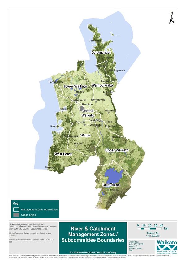
4.3    MANAGEMENT OF FLOOD SCHEME LAND                                                            40
     4.4    WATER QUALITY AND QUANTITY MANAGEMENT                                                      40
     4.5    SUSTAINABLE LAND MANAGEMENT AND IMPLEMENTATION OF CATCHMENT MANAGEMENT
     ACTIVITIES                                                                    42
     4.6    PEAT SOIL MANAGEMENT                                                                       43
     4.7    BIOSECURITY – PEST ANIMALS AND PEST PLANTS                                                 44
     4.8    INDIGENOUS BIODIVERSITY                                                                    44
     4.9    COMMUNITY PARTNERSHIPS, CO-MANAGEMENT AND COMMUNITY EXPECTATIONS                           45
5      GOALS, FOCUS AREAS AND IMPLEMENTATION ACTIONS                                                   46
     5.1    GOALS                                                                                      46
     5.2 FOCUS AREAS                                                                                   48
     5.3    IMPLEMENTATION ACTION PLANS                                                                49
6.     MONITORING AND REVIEW                                                                           59
7.     FUNDING                                                                                         60
     7.1.   Overall Zone Funding                                                                       60
     7.2 Catchment New Works & Biodiversity Enhancement                                                60
       7.2.1 Waikato Regional Council Funding                                                          60
       7.2.2 Other funding sources                                                                     61
GLOSSARY OF TERMS                                                                                      63
REFERENCE LIST                                                                                         64
APPENDIX 1 – Levels of Service for Flood Protection & River Management                                 67
APPENDIX 2 - Priority locations, issues and works in the Lower Waikato Zone as identified in the Waikato and
Waipa Rivers Restoration Strategy.                                                                      73
APPENDIX 3 – Lower Waikato Activity Rates Funding Mix                                                  78

Doc #11815952                                                                                Page 4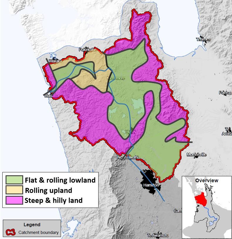
EXECUTIVE SUMMARY
The Vision for the Lower Waikato zone is:
“Well managed catchments that enhance economic and environmental sustainability, recognise
community and cultural aspirations, while mitigating natural risks.”
The purpose of this Lower Waikato Zone Plan (“the zone plan”) is to provide direction for the implementation
of Waikato Regional Council’s (“the council”) Integrated Catchment Management Directorate (ICM) activities
within the zone. The zone plan is focussed on guiding the delivery of catchment and river management activities,
biosecurity, biodiversity, sustainable land management and natural hazard management activities, where these
support the achievement of the zone vision and objectives.
The zone plan supports Te Ture Whaimana o te Awa o Waikato (Vision and Strategy for the Waikato River) and
guides the implementation of activities that give effect to council’s key statutory and non-statutory policy
documents, including the Proposed Waikato Regional Policy Statement, the Waikato Regional Plan and the
council’s Strategic Direction 2016-19.
The zone plan includes the following interrelated 30 year goals to guide the implementation of ICM activities
within the zone:
Provide and maintain sustainable flood protection to rural land and urban areas to the agreed level of
service
Contribute to improving water quality within the zone
Contribute to ensuring that soils within the zone remain productive
Manage the instream impacts of urban development and land use intensification in association with
territorial authorities and other partners
Promote and enhance indigenous biodiversity in both aquatic and terrestrial environments
Support mana whenua and strengthen community partnerships
The zone plan includes a high level programme of implementation actions, grouped in focus areas that respond
to the key matters and goals identified within the plan. All actions included in this plan are either directly funded
through the Lower Waikato Zone or funded as part of wider council activities. A number of the actions rely on
the involvement (and funding) from other stakeholders and these key relationships are specified in relation to
actions where relevant.
The implementation of the zone plan, and its effectiveness, will be monitored and reported on an annual basis
to the community through the Lower Waikato Catchment Committee. Further reviews will be considered on a
three yearly basis to ensure that the plan is reviewed in conjunction with Long Term Plan process and that
progress is being made towards the goals identified.
Doc #11815952 Page 5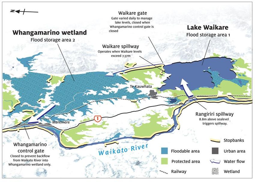
The Vision for the Lower Waikato zone is:

“Well managed catchments that enhance economic and environmental sustainability, recognise
community and cultural aspirations, while mitigating natural risks.”

1        INTRODUCTION
This Lower Waikato Zone is one of eight zones (figure 1), in the Waikato Region; of which each has a zone plan
that guides the delivery of Waikato Regional Council’s (“the council”) Integrated Catchment Management
Directorate (ICM) activities across the Waikato Region. Catchment Committees support ICM to deliver zone plan
activities with a specific focus on catchment and river management activities.

The Lower Waikato zone (“the zone”) consists of the Waikato River catchment area between Ngaruawahia and
the Tasman Sea. It covers an area of 283,757ha, approximately 20 per cent of the total Waikato River catchment
area.

                                                                       The Lower Waikato zone is a
                                                                       challenging operating environment for
                                                                       the council, given the connection of
                                                                       many complex and interrelated
                                                                       natural, economic, social and cultural
                                                                       values and features. An ongoing
                                                                       challenge for the council over the life
                                                                       of this plan will be to prioritise and
                                                                       target limited resources into areas of
                                                                       greatest need for enhanced outcomes.
                                                                       An important consideration in this
                                                                       regard is continuing to maintain
                                                                       agreed levels of service with the
                                                                       community for flood control. Greater
                                                                       integration across council business
                                                                       areas, collaboration with iwi and the
                                                                       community will be essential to
                                                                       addressing the challenges ahead.

                                                                       Figure 1: Waikato Regional Zone Map

Doc #11815952                                                                                Page 6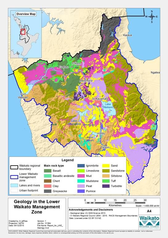
1.1 PURPOSE
The purpose of this Lower Waikato Zone Plan (“the zone plan”) is to provide direction for the implementation
of the council’s ICM activities within the zone.
The zone plan supports Te Ture Whaimana o te Awa o Waikato (Vision and Strategy for the Waikato River) and
guides the implementation of activities that give effect to council’s key statutory and non-statutory policy
documents, including the Proposed Waikato Regional Policy Statement, the Waikato Regional Plan and the
council’s Strategic Direction 2016-19.
The zone plan sets out:
Overall vision for the zone
30 year goals for the zone
Implementation actions for the next 10 year period to meet the goals identified
Processes (and measures) for monitoring and reviewing the plan
The zone vision and goals have been developed in response to the following matters identified as key
challenges/opportunities for the zone over the next 30 years:
Management of the flood scheme and natural hazards risks.
Management of water quality and quantity.
Sustainable land management practices and implementation of catchment management activities.
Management of the instream impacts of urban development and land use intenstification.
Management of indigenous biodiversity and effective pest management.
Development and maintaining effective community partnerships, co-management and community
expectations.
In relation to the implementation of this plan, the council is one of many organisations working to improve
catchment health within the zone. Iwi, district councils, government departments, industry, non-government
organisations (NGOs), community groups and landowners are all active in implementing initiatives to improve
catchment health. The intention of the zone plan is to complement and support the work of these other
agencies and individuals, and align programmes where opportunities arise.
1.2 STRATEGIC FIT
The council undertakes a range of activities to protect the region's water, soil, air, geothermal areas and coasts.
Its vision is “The Waikato Cares locally, competes globally” and its mission is “Working together to build a
Waikato region that has a healthy environment, a strong economy and vibrant communities”
The term sustainability or sustainable development is often used to capture the outcomes of the vision and is
used throughout this plan. 'Sustainable development' means development that meets the needs of the present
without compromising the ability of future generations to meet their own needs11. For sustainable development
to occur we need to balance economic prosperity and our needs for a good quality of life, while ensuring the
quality of our environment.
1
Defined by the World Commission On Environment and Development (the Brundtland Commission named after the Norwegian Prime
Minister).
Doc #11815952 Page 7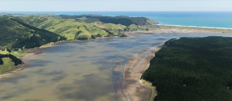
In evaluating quality of life, for many of us, it will include environmental quality, natural resource wealth, leisure
time, working conditions, health and knowledge. These are attributes that we value as a society, but they are
not easily measured. When we make decisions based solely on economics these valuable attributes are often
not accounted for. Waikato Regional Council uses an ecosystem approach when managing the environment.
This means we try to be aware of the links between the air, land, water and coast and the plants and animals
which live there. We recognise the important role our environment plays in our local economy.
This zone plan is a non-statutory document that supports the council’s overall vision and mission and provides
guidance for activities that are implemented primarily through the ICM directorate.
The council's work, functions and priorities are guided by statutory and non-statutory requirements and
decisions made by Councillor representatives and are implemented through five directorates; Community and
Services, Finance, Resource Use, Science and Strategy and ICM as follows:
a. Community and Services - leads, enables and helps deliver community partnerships, customer services,
education programmes, organisational excellence and internal support functions.
b. Finance - council's financial management, regional public transport responsibilities, and our corporate
buildings, facilities and property and corporate planning (including the annual and long term plans).
c. Integrated Catchment management - focussed on delivery of a range of activities in the areas of
catchment management, flood protection, biodiversity, biosecurity, sustainable land management and
hazard/emergency management.
d. Resource Use - consenting and compliance responsibilities and navigation safety functions.
e. Science and Strategy - gathers, analyses, interprets and translates information on Waikato’s natural
resources, community and economy in order to achieve positive regional outcomes. Also includes
consistent delivery of high quality policy advice.
1.3 SCOPE AND SERVICES
The Lower Waikato Zone Plan is a strategic document with a focus on guiding the implementation of river and
catchment management, flood protection and integrated services including animal and pest management, land
management advisory, natural heritage and the interconnection with land drainage, within the Lower Waikato
Zone (which are within the Integrated Catchment Directorate).
Council activities that are not within the scope of this zone plan include:
Implementing and monitoring compliance with council’s rules under the current Waikato Regional Plan,
including those resource consents that are held to undertake work within the scope of this plan;
Monitoring and investigations on the state of the environment, unless utilised to measure performance
on initiatives identified;
Drainage functions – drainage services (with the primary purpose of land drainage) are managed
separately and will be captured in a proposed Drainage Management Plan. There is an interconnection
and through implementing this plan, it is recognised that there needs to be alignment with these
functions.
Doc #11815952 Page 8A summary of the activities and related services, is provided in Figure 2 and further commentary on the primary
activities is provided below.
Integrated Services
Core Zone Services Land Management Advisory
+
Zone Management Oversight
Pest Plant and Animal Mgmt
+
+
Flood Protection Works
Natural Heritage
+
+
River & Catchment Programme
Land drainage
+
(zone funded)
Natural Hazards
(non zone funded)
Regional Services
Science & Strategy
+
Regulatory
+
Community & Services
Figure 2: Lower Waikato Zone Plan - Scope of Activities & Services
Zone Management Oversight (Catchment Oversight)
Through catchment oversight we provide support and servicing to stakeholders, which includes:
General overview of zone issues and overall management, monitoring and coordination of the zone
activities and programmes including collaborative projects with other agencies.
Information and advice to enable responses to enquiries and provision of guidance and information on
river and catchment management within the zone. Management of zone works programmes
Budget preparation and financial management
Support to Zone Catchment Committee
Community and other agency liaison
Doc #11815952 Page 9 Reporting to Council Contribution to development of the Council Long Term Plan Preparation and review of zone and catchment management plans Contribution to the Regional Asset Management Plans Support delivery of the capital renewals programme Doc #11815952 Page 10
Flood Protection Works
Waikato Regional Council is responsible for the provision and maintenance of the flood protection works
throughout the Zone under the Soil Conservation and Rivers Control Act 1941 and the Public Works Act 1981.
The purpose of flood protection activities is to manage the risk of flooding to an agreed Level of Service and the
management of other specific works as agreed with communities.
The flood protection works include large-scale structures that aim to reduce flood risks such as, stopbanks,
pumpstations, floodgates, control gates and detention dams. The works protect communities, schools, roads,
farms and other vital resources, keeping land draining freely in specific geographic areas where schemes have
been agreed with communities. Land has been acquired or easements established for the more significant flood
protection structures and is referred to as ‘scheme land’.
The Land Management team, who are part of the wider asset management team, manages council’s interests
in land and ensures that the necessary agreements, easements and encumbrances are in place and that the
portfolio is managed to the prescribed levels of service. Standards are in place to protect the interests of all
parties involved, including Crown agencies, iwi, district councils and the general public and to meet council’s
responsibilities under legislation including health and safety impacts.
Catchment Programme (maintenance and new works)
Catchment management works including soil conservation and other enhancement works provide considerable
benefits in terms of land and water protection, biodiversity and general environmental enhancement. These
projects focus on reducing the risk and severity of erosion, the loss of productive land and the protection and
enhancement of biodiversity. These actions all contribute to preventing the decline in water quality and the
overall catchment health.
Services and programmes promoted by Council in relation to Catchment management include:
Engagement with landowners and the community to promote and provide information and advice on
soil conservation, biodiversity and water quality protection initiatives.
Preparation of Environmental Protection agreements (landowner agreements).
Management of existing protection works and soil conservation plantings and assets.
Promotion of landuse to capability and conservation planting of erosion prone land.
Protection of high value indigenous vegetation.
Installation of structures to control sediment and water runoff.
Condition and monitoring programmes.
Catchment new works may involve the design, supervision and completion of soil conservation, erosion control
and other catchment management measures. Assets associated with these programmes are usually under the
ownership of individual property owners. Council has an interest and role in ensuring these works are
maintained as they provide both local and wider catchment benefits. All works on private land are voluntary
and subject to agreement with the property owner.
River Management
The purpose of river management activities is to maintain clear, stable waterways. The work includes reducing
congestion of waterways, erosion control on river banks and stability structures in the beds to address the
Doc #11815952 Page 11adverse effects resulting from normal and peak flows within rivers and streams. It also includes the
management of land adjacent to the river or stream (to increase bank stability and reduce erosion) and
retaining and developing fish habitats when clearing river blockages and fish passage barriers.
Typical river management works include:
Controlling bank erosion (by planting, fencing off river banks, construction of rock or other bank
revetment works, or construction of groynes)
Removing blockages and obstructions
River training works (ensuring the flow paths of rivers are stable and optimum channel widths are
maintained)
Bed stability structures, such as weirs, to stabilise the river beds and gradients
Gravel and sand management
Land Management Advisory
The Land Management Advisory Services (LMAS) team aims to achieve improvements in the environmental
footprint of agriculture by working with farmers, industry bodies and stakeholders to facilitate changes on
farms. Some of these changes will be delivered under the Waikato Regional Plan, Healthy Rivers Plan Change 1
(PC1). In particular PC1 requires most farms to have a Farm Environment Plan and provides for sub-catchment
plans where required. LMAS is working to ensure that systems are in place to help farmers to meet their PC1
requirements, and to develop sub-catchment plans as appropriate.
Animal and Plant Pest Management
The animal and plant pest management team have a Regional Pest Management Plan which sets the work
programme and deliverables. Focus is on management of pest plants and pest animals which can impact on
biodiversity and agricultural production.
Natural Heritage
The natural heritage team coordinate and facilitate a wide range of ecological management, restoration and
monitoring projects in the region with a focus on priority natural areas including lakes and wetlands.
Land Drainage
The primary purpose of land drainage is to allow landowners to manage their ground water levels to support
pastoral farming. It includes clearing any ponded water from paddocks within certain timeframes to avoid
pasture damage. There are a number of land drainage areas within the Lower Waikato which are represented
by Committees, including Waikato Central, Franklin Waikato and Aka Aka Otaua.
Regional Hazards
Regional Hazards has primarily two functions; to ensure Resilient Development and have an Emergency
Management capability for WRC. For Resilient Development, the Regional Hazards team work with a number
of internal and external stakeholders to undertake and provide hazard information. The information is used to
ensure robust development decisions are made. The primary Emergency Management functions within the
team are flood and Marine Oil Spill events. The team also provides and leads the framework for other WRC
emergency management obligations.
Doc #11815952 Page 122. LOWER WAIKATO ZONE DESCRIPTION 2.1 ZONE OVERVIEW The Lower Waikato zone covers an area of 283,757ha (some 20 percent of the Waikato River catchment area). The zone is located between Ngaruawahia and the Tasman Sea (figure 3), in the lower reaches of the Waikato River and is the destination of all waters flowing into the Waikato River catchment. As a result, the zone is heavily influenced by activities that occur in the wider hydrological system and ultimately, land use and management in the upper reaches of the Waikato River (Upper Waikato, Waipa, and Central Waikato zones) have considerable impact on the lower Waikato River and the Coastal Marine Area (at Port Waikato). The hydrology and land use within the zone is highly influenced by the Lower Waikato Waipa Flood Control Scheme (LWWCS) and other flood protections works completed in more recent years (that comprises substantial flood infrastructure and assets) (Figure 3). The large-scale modifications to the natural Waikato River environment within the zone has resulted in a number of environmental challenges. The zone once consisted of vast indigenous wetlands bounded to the east and west by hill country. Since the early days of settlement, the land has been cleared and drained for agriculture with a collection of isolated drainage and flood protections works being established as they could be afforded. Following a series of significant floods in the 1950’s the LWWCS was promoted and approved by Central Government with construction occurring from the 1960’s to the 1980’s. The LWWCS was a comprehensive suite of works that included works within the Main Waikato River channel to lower river flow levels, the management of flood ponding through the Community Control Gates and spillways and an improved standard of flood protection and drainage works to improve land productivity. The scheme infrastructure modified the natural landscape through the drainage of wetlands and changes in flood water ponding areas, retention times and flow paths. In turn the scheme has enabled communities to prosper, particularly through the improved security of the SH1 and Main Trunk rail corridors plus increased agricultural and horticultural productivity. Today only 16 per cent of the zone has native vegetation and willow wetlands and 3 per cent is open water, including 29 natural lakes. Farming and forestry now, respectively, occupy 74 per cent and 5 per cent of the land area. Due to the flood control and drainage works, the zone has a vast range of flood management and drainage infrastructure that requires ongoing maintenance and is influenced by the Upper Waikato, Central Waikato and Waipa hydrological systems. Approximately 17,200ha of the floodplain is directly protected by the LWWCS infrastructure and other works completed since. This includes a network of 256km of stopbanks, 274 floodgates and 64 pumpstations (figure 4), aimed at protecting low-lying, flood prone land, effectively disconnecting almost half of the lower floodplain from natural interaction with the river The zone is a large geographic area with a rating base of approximately 16,000 ratepayers and accommodates a range of small urban settlements including Taupiri, Huntly, Te Kauwhata, Mercer, Pokeno, Tuakau and Port Waikato. Recent urban expansion in Te Kauwhata and Pokeno, has occurred, which has resulted in the change of land use from agricultural to urban use and has increased the need for wastewater and stormwater management. Land fragmentation from urban expansion and lifestyle blocks around some of these urban centres has also occurred. Agriculture (dairy and dry stock farming) and horticulture alongside industrial activities including power generation, coal mining, quarrying and sand mining are dominant economic activities in the zone which also influence catchment management health in the zone. Doc #11815952 Page 13
Doc #11815952 Page 14
Figure 3: Lower Waikato Zone Map

2.2      CULTURAL HERITAGE
The Lower Waikato zone has a rich cultural heritage and has been a stronghold for Māori for many generations.
Historically the Lower Waikato River was an important transport route for trade and this ability to access fertile
areas contributed to the growth and importance of the Waikato Region. Key iwi within the lower Waikato
include Waikato-Tainui, Ngati Haua, Ngati Tamaoho, Ngati Tipa, Ngati Te Ata, Te Akitai Waiohua and Hauraki
iwi. Each iwi has its own rohe within the zone and significant ongoing interests in maintaining and restoring the
health of the lower Waikato. Iwi particularly associate the Waikato River with spiritual values, regarding the
river as a source of their mana.

2.3      KEY FEATURES
The Lower Waikato zone contains a range of unique natural habitats, landscapes, ecosystems and infrastructure.
A range of native plants and animals rely upon special and unique environmental conditions found in the
remaining natural areas of the Lower Waikato, including its waterways, hill-country, floodplains, lakes, wetlands,
estuaries and coast. A summary of the key features of the zone is provided below as context for the key matters
identified in Section 4 of this plan. It is noted that the below summary is not exhaustive, rather it provides a
“snapshot” of the complex operating environment of the zone.

2.3.1 The Waikato River
The dominant feature of the Lower Waikato zone is the Waikato River and its associated tributaries, lakes,
wetlands and estuary. The Waikato River and its associated wetlands, lakes and waterways support a diverse
range of native and exotic fish communities including 19 species of indigenous freshwater fish (Spiers, 2001).
Many of the indigenous freshwater fish species present in the river are diadromous, needing to move to and
from the sea during their life cycle. Recent work also indicates that connected riverine lakes, such as Waahi,
Whangape and Waikare are also crucial sources of recruitment to their own catchments and wider areas of the
lower river for some iconic endemic fish species like banded and giant kokopu. While it is the largest system in
the region, the Waikato River is also one of the most impacted in terms of fish habitat and nutrient enrichment.
Loss of bush catchments due to farm and forestry development, heavy industry discharges (temperature,
nutrients, and heavy metals), floodplain and wetland loss, heavy recreational and commercial harvest, flood
protection and drainage collectively have reduced the fishery of this river. Of note is that the lower Waikato has
the highest pest fish biomass in New Zealand.

Hydro electricity generation is a significant feature of the Waikato River catchment. There are two aspects to
the effects of hydro development on the Lower Waikato. Firstly the Waikato Hydro adds storage in Lake Taupo
and the dams, and thus tends to lower the peaks and increase the troughs. Secondly, the Tongariro Hydro
Scheme inputs additional water into the catchment, with an average increase of 10% at Ngaruawahia. A full
assessment was done at the time and it was concluded the additional water wouldn’t affect food peaks, but
would increase the duration of moderate floods. Offset works undertaken were aimed at strengthening
stopbanks and improving the river channel to carry the additional water.

2.3.2 Floodplains and associated flood control scheme infrastructure
There is a substantial 36,400ha of floodplains and historically this comprised of low lying wetlands and lakes.
Since human settlement, agricultural production has increased in the zone and isolated flood protection and
drainage schemes were implemented as they could be afforded. In the 1950’s constant inundation of the land
within the lower Waikato emphasised its high susceptibility to flooding and the associated effects on the

Doc #11815952                                                                                  Page 15
agricultural and horticultural industry. In response to these effects, the Lower Waikato Waipa Flood Control
Scheme (LWWCS) was developed in the 1960s by the Waikato Valley Authority.
The services provided by the flood protection and land drainage schemes have a variety of quantifiable
benefits which enables contribution to the region’s economy, including:
Protection of land and property, which reduces associated potential damage and increases the value
of the land
Improving the productivity of land, which adds value to the regional economy
Protection of regionally and nationally important infrastructure associated with activities such as
transport (e.g. roads including state highways and rail) and electricity transmission
Avoided costs from flood damage that would otherwise result if the schemes were not in place (or
maintained to the necessary standard)
The continuous development and improvement of flood protection and drainage assets has resulted in
thousands of hectares of land being drained and then utilised for intensive agricultural or horticultural
production. Approximately 17,200ha of the floodplain is directly protected by the LWWCS infrastructure and
other works completed since. This includes a network of 256km of stopbanks, 274 floodgates and 64
pumpstations (figure 4), aimed at protecting low-lying, flood prone land, effectively disconnecting almost half
of the lower floodplain from natural interaction with the river (Mulholland, 2010; Speirs et al., 2010). Other
works also included channel modifications, flood ponding management, spillways and detention dams as ways
to manage flood flows throughout the zone.
The LWWCS works reproduces the natural water storage functions of Lake Waikare and Whangamarino
Wetland, but in a more controlled manner. A sluice gated culvert moves water from the Waikato River to Lake
Waikare and a canal takes water directly from Lake Waikare to the Whangamarino Wetland.
Control gates at the western outlet of Whangamarino Wetland on the Whangamarino River prevent backflow
from the Waikato River into the wetland during flood events. Management of the control gate only allows water
flow through once the peak of the Waikato River event has passed. Accordingly, the system lowers the flood
peak in the Whangamarino Wetland by 40cm to 60cm, reducing the chance of serious damage to surrounding
land. The control scheme also has a spillway near Rangiriri which will spill peak flows from the Waikato River
into Lake Waikare once the level of the river approaches its maximum capacity. Since its construction, the
Rangiriri spillway has operated only once in 1998.
Doc #11815952 Page 16Figure 4: Key flood scheme and land drainage infrastructure within the Lower Waikato zone (indicative only) 2.3.3 Water Supply Sources & Infrastructure Auckland’s water supply is obtained from rainwater stored in dams, the Waikato River and an underground aquifer. Auckland’s 12 water supply reservoirs are located in the Waitakere (5), Hunua Ranges (4), Helensville (2) and Papakura (1). The source for water storage is augmented by a take from the Waikato River near Tuakau (Watercare, 2017). Watercare’s Water takes from the Hunua Ranges Of the Watercare dams, two are within the Lower Waikato Zone, the Mangatangi and Mangatawhiri dams, which are located in the Hunua Ranges. The Mangatangi dam is within the headwaters of the Mangatangi Stream. The sub-catchment of the Mangatangi dam is in native vegetation and is owned and administered by the Auckland Council. Constructed in 1977, the Mangatangi dam has over double the capacity of the other Hunua dams covering a lake area of 185 hectares and a capacity of 35.3 gigalitres. The Upper Mangatawhiri reservoir is within the headwaters of the Mangatawhiri Stream. The sub-catchment of the Mangatawhiri dam is also in native vegetation and is owned and administered by the Auckland Council. Constructed in 1965, the Mangatawhiri dam covers an area of 128.5 hectares and has a capacity of 16.2 gigalitres. (Watercare, 2017). Doc #11815952 Page 17
Watercare purchased the rights to the existing plantation pine forest in the Hunua Ranges in 2017. A project
has been defined where, over the long term, all exotic forest is reverted into a stable and ecologically
appropriate land cover. This aim to remove the risk associated with mass agrichemical contamination and
sedimentation which are commonly associated with commercial forest activities.

Auckland is growing by the size of Hamilton every four years (Waikato Regional Council, 2016) and consequently
there is an ongoing demand for water - including that provided by the Mangatangi and Mangatawhiri Dams.
Therefore, these catchments directly support Auckland, being the largest contributor to the national gross
domestic product (GDP).

Watercare’s Water Take from the Waikato River – The Tuakau Water Treatment Plant

Over the next 25 years Auckland's population is expected to double, so Watercare have built a water treatment
plant to take water from the Waikato River to keep up with future demands. Located in Tuakau, the Waikato
Water Treatment Plant was opened in 2002. The Treatment Plant has been upgraded to increase supply from
75 million litres per day (MLD) to 125 MLD. It will supply much of this additional water to the Auckland area.

2.3.4 Regional and National Infrastructure
A number of regional and national infrastructure assets in the Lower Waikato Zone are protected by the flood
protection and land drainage schemes. This includes 50 year flood protection of infrastructure associated with
transport (e.g. roads including state highways and rail) and electricity transmission.
a) State Highway network

The Waikato Expressway – State Highway 1, (including the section within the Lower Waikato Zone), has been
identified as one of seven roads of national significance. Roads of national significance are identified as New
Zealand's essential state highways which provide the main links between our major areas of economic activity,
facilitating the efficient transport of goods and people (Saha International Limited, 2010).

b) North Island Main Trunk Railway

The North Island Main Trunk railway connects Auckland with Wellington by rail, with the final section being
completed in early 1909. The railway is located west of Lake Waikare and Whangamarino wetland catchment
area. Nearly 45 per cent of the national total of rail freight, originates in, has a destination in, or passes through
the Waikato region (New Zealand Trade and Enterprise, 2016).

c) The National Grid

Transpower New Zealand Limited is the state-owned enterprise that owns and operates New Zealand’s high
voltage transmission network (the national grid), which carries electricity throughout the country. The national
grid is vitally important with the ongoing New Zealand expanding population, an economy becoming increasingly
reliant on electricity with an expectation of a reliable supply and the increasing amount of remote and
intermittent (for example wind) generation being built (Transpower New Zealand Limited, 2017). The National
Grid 220kv and 400kv transmission lines traverse the CMP catchment area, on the eastern side of Lake Waikare
and Whangamarino wetland.

Doc #11815952                                                                                     Page 18
2.3.5 Land Cover and Land Use
Land cover is predominantly pasture (71 %) with smaller areas of native vegetation (11 %) (figure 5). Land use is
mainly sheep and beef farming (38 %) followed closely by dairy farming (32 %) and smaller areas, mainly on the
rolling volcanic land around Pukekohe and Pukekawa, are used for cropping and vegetable growing (figure 6)
(Singleton 2017).

Figure 5: Land cover in the Lower Waikato Zone

Figure 6: Land use in the Lower Waikato Zone

Doc #11815952                                                                                 Page 19
2.3.6 Geology
The prominent geology in the zone includes peat, sandstone, siltstone and mudstone, with basaltic and
greywacke provinces at the northern extreme (Figure 7). The southern end of the zone is comprised of the
Hamilton lowlands area. This area is a broad alluvial plain of pumice-dominated material deposited by the
Waikato River, which covers the underlying ignimbrite deposits flattening the topography.

Along the length of the Waikato River, across the entirety of the zone, there are alternating sand, mud, and silt
deposits. These were deposited during the migration of the Waikato River throughout the Quaternary, and are
primarily pumice and ash dominated (predominantly originating from the voluminous 26.5 ka Oruanui eruption).
Peat bogs also formed in embayments created as the river migrated (notably in the Hamilton lowlands and to
the east of Meremere).

Another evident feature of the LWZ geology is the basaltic deposits to the north. These were emplaced later
than the Pliocene and sourced from a vent located approximately five kilometres from Tuakau. There is also a
fault-bounded zone of uplift at the north-eastern extent of the area, where greywacke deposits are exposed.

Volcanic ash is a parent material of soil in the area but also it may be mixed with materials derived from the
underlying andesitic rock. More recent pumiceous ash from the Mangaone, Kaharoa, and Taupo eruptions is
also present as a fine, white sand distributed throughout the soil structure (Edbrooke, 2005).

Depending on the type of minerals present in the soil, clays can also be found along the slopes bounding the
Waikato River. These materials are very responsive to changes in moisture content by swelling or cracking. In
contrast, the ash soils have a high phosphate retention and low cohesion. This influences risk of debris flows and
landslides in the district.

Doc #11815952                                                                                  Page 20
Figure 7: Geology in the Lower Waikato zone

Doc #11815952                                 Page 21
2.3.7 Topography and Landforms

The catchment is a mixture of terrain (figure 8). Much of it is flat to rolling land (52 %) with moderately steep or
steep hills (46 %) which in the west can have bluffs and rocky outcrops. Rolling land forms the hills at the base
of the steep land and also the low hills within the central catchment. Flat to undulating land covers lower areas
of the central catchment and includes alluvial and peatland (41 %) (Singleton 2016).

Figure 8: Landforms in the catchment

2.3.8 Peat soils
The Waikato region is home to half of all New Zealand’s peat. Waikato peat soils cover about 94,000 hectares
(Waikato Regional Council, 2006) and the Lower Waikato Zone contains half of this with 47,000 hectares (figure
7) and has the most diverse range of peat soil types in the region. Although, the extent and depth of the peat

Doc #11815952                                                                                    Page 22
resource in the Lower Waikato Zone is not well defined, due to limited comprehensive mapping and the nature
of the peat deposits (See for example; Palmer & Hainsworth, 2012).

The competing uses of peat soils in the Waikato have long been a source of conflict. Historically, the peat areas
in the Waikato region represented unique wetland ecosystems however about 80% of our peat soils have been
drained, mostly for agriculture. The remainder is managed as conservation reserves, for wildlife and flood
protection. Drained peat, if properly managed, is a highly productive resource. However, drainage results in
ongoing peat subsidence which has a range of land and drainage management consequences, many of these are
not well understood.

2.3.9 Wetlands and Forests
The floodplains were once clothed in a complex of wetlands and forests. Totara matai forests would have grown
on the better drained soils, while kahikatea pukatea forest would have been on more poorly drained alluvium.
A mix of bog, fen and swamp wetlands shared the alluvial surfaces with these forests. The vast majority of the
forests of the floodplains have been cleared, with less than 2% remaining. Likewise, the more fertile wetlands
have been preferentially cleared, while more of the less-fertile fens and bogs remain. The remaining kahikatea
forest, totara matai forests and wetlands are key biodiversity features (requiring protection) in the zone.

A distinct feature of the Lower Waikato zone is the Whangamarino Wetland. This wetland is the largest wetland
complex in the Waikato River Catchment and possesses significant ecological values. It serves as an outstanding
site for promoting the value of wetlands and species conservation.

Covering an area of approximately 7,500ha, this internationally significant Ramsar2 wetland is a mosaic of
swamps, fens and peat bogs dissected by the Whangamarino and Maramarua Rivers. It is the second largest
wetland complex in the North Island and serves as a representation of habitat that is significantly unrepresented
in New Zealand. The Whangamarino wetland is natural habitat on a landscape scale. This wetland promotes
conservation of species such as the Australasian bittern/ Matuku with 20% of the New Zealand population of
this species residing in the wetland. It is an important habitat for a range of other threatened species, including
grey teal, spotless crake, North Island fernbird, black mudfish, water milfoil, swamp helmet orchid and yellow
bladderwort.

2.3.10 Shallow Lakes
The Lower Waikato zone contains 29 shallow lakes (peat, riverine and dune lake types), generally characterised
by an average depth of less than three metres. Like most shallow lakes in the Waikato region, the riverine and
peat lakes have been formed in association with the Waikato River system and its floodplains, and the formerly
extensive peat bogs of the region (Dean-Speirs, et al., 2014). The function of shallow lakes is notably different
to deep lakes3, and they are more vulnerable to deterioration over time. Lake Whangape, the zone’s second
largest lake, retains its’ natural water fluctuation range supporting a wide variety of significant wetland types
including the best remnant of floodplain kahikatea forest in the Lower Waikato zone. Lake Otamatearoa, a dune

2 The Convention on Wetlands of International Importance, called the Ramsar Convention, is the intergovernmental treaty that provides the framework
for the conservation and wise use of wetlands and their resources. RAMSAR Website download at http://www.ramsar.org/

3 Shallows lakes are capable of supporting submerged aquatic plants, are regularly stirred up by wind and wave actions disrupting lake bed sediment,
are very susceptible to changes in hydrology due to catchment use, and are more heavily impacted by invasive pests.

Doc #11815952                                                                                                                 Page 23
lake near Waiuku, has the highest biodiversity ranking of all lakes in the Lower Waikato zone due to its’ high
biodiversity values and excellent water quality. Lake Waikare is the largest lake in the Lower Waikato catchment
and is extremely shallow. It is valued for a range of purposes including for flood protection storage (section
4.1.1). Waikare drains to the internationally recognised Whangamarino Wetland. A Catchment Management
Plan for Lake Waikare and Whangamarino has recently been developed.

2.3.11 Port Waikato and estuarine environment
Port Waikato and its associated coastal environment are considered to be a high value feature of the zone. Port
Waikato is situated on the zone’s only coastline, at the mouth of the Waikato River and is the only estuary in the
zone, containing a varying mixture of fresh and salt water, as the Waikato River flows into the sea and the tides
rise and fall. This estuary is home to an assemblage of fresh and saltwater fish taking advantage of the rich
resources of the Waikato River Delta. Pest fish present include koi carp, however it appears that the salt
concentrations are a deterrent. Typical of river mouths, the estuarine vegetation is generally restricted to a
fringe along the lower river banks. These fringing rush and sea meadow bands are compromised and threatened
by the invasive pest plant, saltwater paspalum. Another pest plant is alligator weed. Lower down in the tidal
range are the most ecologically significant estuarine vegetation, the seagrass beds (Graeme, 2011).

The delta of the Waikato River is known for its whitebait fishery, providing a habitat, nursery and conduit for
migrating freshwater species. The delta is also home to a number of exotic and indigenous waterfowl,
marshbirds, and shorebirds using the various mudflat, sandflat, saltmarsh and wetland habitats for feeding and
breeding (Ryder, Bentley, Saunders, & De Luca, 2016). Tidal effects in the river are evident upstream to at least
Mercer, providing spawning habitat for inanga and the other whitebait species. Maui dolphins (Cephalorhynchus
hectori maui) are known to use the coastal waters near Port Waikato, whilst the river mouth also offers habitats
for seals, dolphins and sharks.

Coastal erosion is currently affecting the open coast which has impacted the carpark and surf lifesaving tower.
The community has been well engaged in a collaborative approach with Regional Council, DoC and led by
Waikato District Council. Recent shoreline survey using aerial photographs have also identified erosion along
the inner river mouth.

The sand dune system is also important as a natural buffer for coastal erosion and as a landscape feature and
includes a number of dune lakes, unique to the rest of the Waikato Catchment. Sand mining (extraction for iron
sands) occurs near Port Waikato, affecting the sand reserves in beaches and dunes, as well as the dune
ecosystems and habitats that existed prior to mining. This can make coastal environments vulnerable to storms
as buffering capacity is reduced.

2.3.12 Coastal Marine Area
The Lower Waikato Zone includes a section of the west coast extending from Port Waikato Township northwards
to a point just south of Karioitahi on the Awhitu. The Coastal Marine Area extends from the mean high water
springs along this coast to 12 nautical miles out into the Tasman Sea and covers a distance of approximately 8km
up the Waikato River, and is the destination of all water flowing out of the 425km Waikato River – discharging
into the Tasman Sea. There is very little information relating to biotic environment of the open coastline.

Doc #11815952                                                                                  Page 24
3. LEGISLATIVE AND POLICY FRAMEWORK
This section outlines the legislative and policy (both statutory and non-statutory) framework that has informed
the development of the vision, goals, focus areas and implementation actions set out in this zone plan.
Figure 9 provides an overall summary of the key legislative and policy framework for the zone plan, along with
the key areas where the zone plan has influence over council plans and policies.
Figure 9: Key linkages between the zone plan and other key legislation and policy requirements
3.1 LEGISLATION AND STATUTORY PLANS
The zone plan implements a number of the council’s statutory responsibilities under a variety of statutes,
including:
• Resource Management Act 1991 (RMA)
• Soil Conservation and River Controls Act 1941
• Local Government Act 2002
Civil Defence Emergency Management Act 2002
The key statutory policy documents and legislation that have guided the implementation activities proposed
within this zone plan are summarised below.
Vision and Strategy for the Waikato River
The primary direction-setting document for the protection of the Waikato River and its catchments is Te Ture
Whaimana o te Awa o Waikato (Vision and Strategy for the Waikato River).
Developed by the Guardian Establishment Committee (predecessor to the Waikato River Authority) in
consultation with the Waikato community, as part of the wider Waikato River treaty settlement co-management
Doc #11815952 Page 25negotiations, the Vision and Strategy for the Waikato River is administered by the Waikato River Authority. It
was initially given statutory recognition via the Waikato River Acts in 2010 and 2012.
The Vision and Strategy for the Waikato River is included in its entirety into the proposed Waikato Regional
Policy Statement, and regional and district plans therefore must give effect to it. If there are any inconsistencies
between the Vision and Strategy and any Resource Management Act planning document, including any national
policy statement, the Vision and Strategy prevails.
Fundamental to the vision are the following key principles:
Commitment to the restoration and protection of the river in its widest sense (including iwi and
community relationships).
Adoption of a precautionary approach.
Recognition given to cumulative effects.
Application of a holistic, integrated approach to the management of resources.
Recognition and application of two worlds of knowledge – Mātauranga Māori and western science.
Regional Policy Statement (2012)
The Regional Policy Statement (RPS) has objectives for managing fresh water (3.14), riparian area and wetlands
(3.16), ecological integrity and indigenous biodiversity (3.19), natural hazards (3.24), and values of soils (3.25).
It also has new policies regarding managing coastal marine areas (Chapter 7), fresh water bodies (Chapter 8),
indigenous biodiversity (Chapter 11), natural hazards (Chapter 13) and soils (Chapter 14). These objectives and
policies are relevant to the implementation actions set out within this plan.
Waikato Regional Plan (2007) and Regional Coastal Plan (2010)
The Waikato Regional Plan (WRP) applies across the whole of the Waikato region (except for the “Coastal Marine
Area”), and provides the regulatory framework for resource management. The WRP implements the RPS,
relevant National Direction, and Treaty Settlement legislation. The Waikato Regional Coastal Plan (WRCP)
contains policies and methods to manage the allocation and use of coastal resources in the “Coastal Marine
Area” (” (the sea area below mean high water spring tide out to the 12 mile regional limit); and applies to the
Port Waikato Estuary up to approximately 8km from the coast. The WRCP implements the RPS, the New Zealand
Coastal Policy Statement, and other relevant legislation (e.g. parts of the Marine and Coastal Area Act).
A full review of the WRCP and WRP is currently being planned by council. Ultimately the two plans will be
combined and replaced by one: the Waikato Resource Management Plan. Notification of the first phase of the
plan review (most of the current coastal plan and priority topics for the regional plan) is expected in 2019/20,
with adoption of the revised Plan programmed for 2025.
Proposed Waikato Regional Plan Change 1 - (Waikato and Waipa River Catchments)
The council has notified and is in the process of implementing proposed Plan Change 1 – Waikato and Waipa
River Catchments (Healthy Rivers: Plan for Change/Wai Ora: He Rautaki Whakapaipai). Plan Change 1 seeks to
achieve reduction, over time, of sediment, microbial pathogens, nitrogen and phosphorus entering water bodies
(including groundwater but excluding coastal waters) in the Waikato and Waipa River catchments.
Doc #11815952 Page 26Regional Pest Management Plan 2014-2024
The Waikato Regional Pest Management Plan (RPMP) sets out the strategic and statutory framework for
managing plant and animal pests in the Waikato region. Objectives and the management approach for specific
plant and animal pests present within the zone are contained in the plan. It is noted that the RPMP review is
planned to commence in late 2017 starting with the release of a discussion document in early 2018. The actions
in the zone plan can inform this process.
National Direction on Natural Resource Management
Central Government, through the Ministry for the Environment, has a programme of National Direction work
that seeks to provide overall direction and consistency around management of natural resources. This involves
either development, or review, of National Environment Standards, National Policy Statements, and National
regulation.
Key national directions that will affect catchment management in this zone (and all zones) include the National
Policy Statement for Freshwater Management (2011), national regulation around stock access to water and
swimmability standards, the National Environmental Standard for Plantation Forestry (2017), and the New
Zealand Coastal Policy Statement (2010). This zone plan would need to be amended to give effect to any
national direction which requires implementation through catchment management.
Waikato River Treaty Settlements
Council acknowledges the special position of tangata whenua within the region and recognises the need to work
with iwi/hapu in river and catchment management.
The Waikato-Tainui Deed of Settlement was passed into law in May 2010 and key Treaty settlement for the
Lower Waikato Zone. The agreement established a River Management Authority to oversee governance of the
river (the Waikato River Authority), and the Vision and Strategy for the Waikato River is input in its entirety
directly into the RPS. This Treaty settlement has resulted in land ownership changes and many large areas of soil
conservation and river control (SCRC) land being vested in the Waikato Raupatu River Trust.
Other relevant treaty settlement legislation within the zone includes:
Ngati Tūwharetoa, Raukawa, Te Arawa River Iwi Waikato River Act (2010)
Nga Wai o Maniapoto (Waipa River) Act (2012)
Pare Hauraki Collective Redress Deed
Ngati Haua Claims Settlement Act (2014)
Waikato Raupatu Claims Settlement Act (1995)
Māori Fisheries Act (2004)
Treaty settlements have resulted in a range of agreements between the council and river iwi. These agreements
set out a co-management framework for managed properties; sites of significance (reserve sites for the purposes
of section 70 of the Waikato River Settlement Act); and Waikato River related lands where applicable, and
include:
Co-management Agreement for Waikato River Related Lands - Waikato Raupatu River Trust and Waikato
Regional Council (2012)
Doc #11815952 Page 27 Joint Management Agreement Waikato Raupatu River Trust and Waikato Regional Council (2013) 3.2 KEY NON-STATUTORY POLICIES AND PLANS Waikato Regional Council Strategic Direction 2016 to 2019 Waikato Regional Council’s strategic direction guides work and sets priorities for the Council’s work up to 2019. It also reflects community desires and needs, and identifies key factors that will determine whether the council is successful in achieving its strategic direction. Priorities under the Council’s strategic direction are: Support communities to take action on agreed outcomes. Forge and strengthen partnerships to achieve positive outcomes for the region. Positively influence future land use choices to ensure long term sustainability. Manage freshwater more effectively to maximise regional benefit. Increase communities understanding of risks and resilience to change. Enhance the value of the region’s coasts and marine area. Shape the development of the region so it supports our quality of life. The zone plan will assist the council in delivering its strategic direction. The key connections from the zone plan to the strategic direction are summarised in Table 1 below. Further information on the Zone goals is detailed in section 5. Doc #11815952 Page 28
Table 1: Lower Waikato Zone Plan connections with the strategic direction
REGIONAL PRIORITIES
and
and
Development
Communities
Partnerships
Freshwater
Resilience
Regional
Coastal
Marine
Risks
Land
1 Provide and maintain affordable
flood protection to rural land and
urban areas.
2 Contribute to improving water
quality in the zone.
3 Contribute to ensuring that soils
within the zone remain
productive.
4 Promote and enhance
indigenous biodiversity in both
ZONE PLAN GOALS
aquatic and terrestrial
environments.
5 Support mana whenua and
strengthen local community
partnerships.
Doc #11815952 Page 29You can also read