Human Activity and the Environment: Forests in Canada - Human Activity and the Environment 2017
←
→
Page content transcription
If your browser does not render page correctly, please read the page content below
Catalogue no. 16‑201‑X
ISSN 1923-6751

 Human Activity and the Environment 2017

Human Activity and the Environment:
Forests in Canada

Release date: March 14, 2018
How to obtain more information
For information about this product or the wide range of services and data available from Statistics Canada, visit our website,
www.statcan.gc.ca.

You can also contact us by

email at STATCAN.infostats-infostats.STATCAN@canada.ca

telephone, from Monday to Friday, 8:30 a.m. to 4:30 p.m., at the following toll-free numbers:
   •• Statistical Information Service                                                                   1-800-263-1136
   •• National telecommunications device for the hearing impaired                                       1-800-363-7629
   •• Fax line                                                                                          1-514-283-9350

Depository Services Program
   •• Inquiries line                                                                                    1-800-635-7943
   •• Fax line                                                                                          1-800-565-7757

Standards of service to the public                                         Note of appreciation
Statistics Canada is committed to serving its clients in a prompt,         Canada owes the success of its statistical system to a
reliable and courteous manner. To this end, Statistics Canada has          long‑standing partnership between Statistics Canada, the
developed standards of service that its employees observe. To              citizens of Canada, its businesses, governments and other
obtain a copy of these service standards, please contact Statistics        institutions. Accurate and timely statistical information could not
Canada toll-free at 1-800-263-1136. The service standards are              be produced without their continued co‑operation and goodwill.
also published on www.statcan.gc.ca under “Contact us” >
“Standards of service to the public.”

                                 Published by authority of the Minister responsible for Statistics Canada

                       © Her Majesty the Queen in Right of Canada as represented by the Minister of Industry, 2018

              All rights reserved. Use of this publication is governed by the Statistics Canada Open Licence Agreement.

                                                   An HTML version is also available.

                                               Cette publication est aussi disponible en français.
Contents

Highlights.................................................................................................................................................................................... 4
Section 1 Introduction............................................................................................................................................................... 8
      Textbox 1.1 What you need to know about this study.....................................................................................................................9
        Definitions: forest, other wooded land, tree cover, land cover and land use.................................................................................9
Section 2 – Forests and the forest sector in Canada.............................................................................................................. 11
   2.1 Forest resources.......................................................................................................................................................................11
      Forest area and structure...............................................................................................................................................................14
        Forest type and species................................................................................................................................................................15
        Age class.......................................................................................................................................................................................19
        Timber volume.............................................................................................................................................................................20
      Forest change.................................................................................................................................................................................22
        Natural disturbance......................................................................................................................................................................22
        Deforestation...............................................................................................................................................................................26
      Textbox 2.1 Climate change and Canada’s forests..........................................................................................................................29
   2.2 Forest products and ecosystem services..................................................................................................................................32
      Timber............................................................................................................................................................................................32
      Non-timber forest products...........................................................................................................................................................37
      Biodiversity and ecosystem services...............................................................................................................................................38
        Biodiversity...................................................................................................................................................................................39
        Ecosystem services.......................................................................................................................................................................41
      Textbox 2.2 Urban forest cover in Canadian metropolitan areas...................................................................................................43
   2.3 Forest sector ...........................................................................................................................................................................44
      Contribution of forest sector to the economy...............................................................................................................................45
      Contribution to employment, wages and communities..................................................................................................................47
        Forest sector-based communities................................................................................................................................................48
   2.4 Forest management..................................................................................................................................................................53
      Harvesting and regeneration..........................................................................................................................................................53
        Harvesting methods.....................................................................................................................................................................57
        Regeneration methods.................................................................................................................................................................58
      Textbox 2.3 Environmental impacts associated with the forest sector...........................................................................................59
        Impacts associated with forest management and logging.............................................................................................................60
        Other environmental impacts from the forest sector..................................................................................................................61
      Forest management certification....................................................................................................................................................61
      Protected areas..............................................................................................................................................................................62
   2.5 Conclusion................................................................................................................................................................................65
Section 3 Glossary.................................................................................................................................................................... 66
Acknowledgements.................................................................................................................................................................. 69
Human Activity and the Environment 2017:
Forests in Canada
Highlights
Human Activity and the Environment 2017: Forests in Canada tells the story of Canada’s forests, providing up-to-date
statistics on forest area; forest products and ecosystem services; economic and social contributions of the forest
sector; and forest management activities and environmental impacts.1
The following bullets present selected highlights from the report:
• Canada is rich in forest resources. In 2015, the country’s 3.47 million km2 of forest—located in the boreal and
temperate zones—accounted for 9% of forests worldwide and 35% of the country’s total area.
• The boreal zone covers over 5.5 million km2 of Canada—from Newfoundland and Labrador to the Yukon—including
all or substantial parts of ten ecozones. More than three-quarters of Canada’s forest is located in the boreal zone.
Canada has some of the largest areas in the world of remote and inaccessible forest landscapes.
• Coniferous forests account for 68% of Canada’s forest area with spruce forests being the most common.
Spruce forests are particularly characteristic of the boreal zone, accounting for large proportions of forest area in
the Taiga Cordillera (89%), Hudson Plains (89%), Taiga Shield (86%) and Taiga Plains (85%).
• Insect outbreaks damaged an estimated 176,318 km2 of forest in 2015. The largest proportions of damage were
caused by the eastern spruce budworm (38%) and the forest tent caterpillar (29%).
• In 2015, 7,140 wildfires burned a total of 38,616 km2 of forest land—49% were started by lightning strikes, 48%
had a human source of ignition and the remainder had an unknown cause. Fires started by lightning were responsible
for the majority of the burned area.
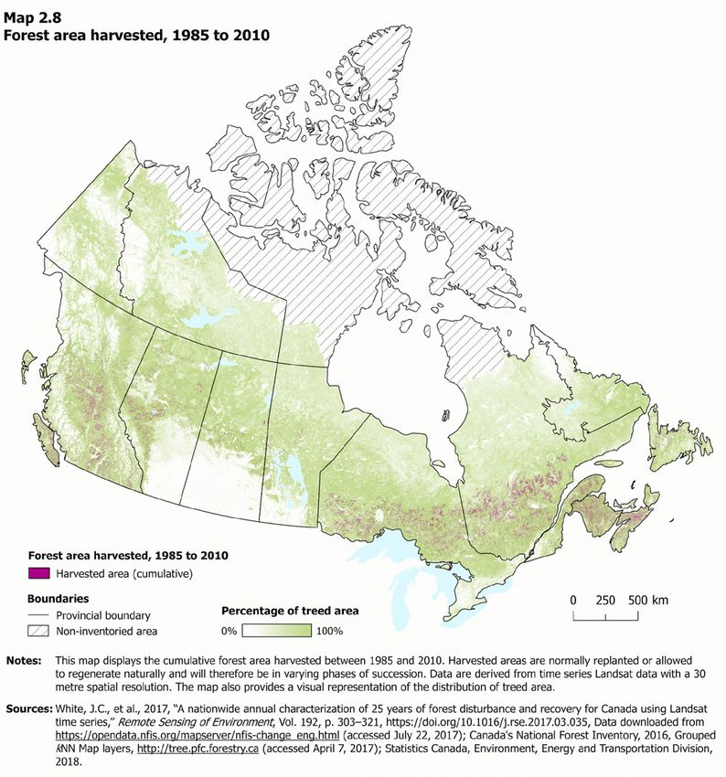
• In 2015, Canada harvested 7,796 km2 of forest, which accounted for 0.2% of Canada’s 3.47 million km2 of forest
area. Clearcutting was the most common method and was used to harvest 6,608 km2 of forest—85% of the total
harvested area in Canada.
• Canada’s forest area decreased 0.3% from 3.483 million km2 in 1990 to 3.471 million km2 in 2015. Over this period,
most forest converted to other land uses was used for agriculture (42%), mining, oil and gas (24%), built-up area
(16%), hydro-electric infrastructure and reservoirs (13%) and forestry roads (6%).
• The value of Canada’s accessible timber stocks—a component of natural resource wealth—was estimated at
$215.4 billion in 2016.
• The total volume of roundwood harvested in Canada was 160.5 million m3 in 2015, up 35% from the most recent
low in 2009. By volume, British Columbia accounted for the greatest proportion at 42%, followed by Quebec
(18%) and Alberta (17%).
• In 2014, gross domestic product (GDP) for the forest sector in Canada was $22.1 billion with wood product
manufacturing responsible for 39% of this total, followed by paper manufacturing (36%), forestry and logging
(17%) and support activities for forestry (8%). The forest sector’s overall contribution to GDP has declined,
from 1.7% in 2007 to 1.2% in 2014.
• As a proportion of total Canadian exports, forest products including logs and pulpwood, lumber and pulp and paper,
have declined from 12% in 1997 to 6% in 2016. In 2016, exports were valued at $29.5 billion, with exports of
lumber, sawmill and millwork products and pulp and paper accounting for the large majority of this total.
1 This report is based on data from the National Forest Inventory (NFI), the National Forestry Database (NFD) and Statistics Canada, and also includes a variety of information from other
sources. For more information see Textbox 1.1 and complete citations in Section 2.
Statistics Canada — 16-201-X Human Activity and the Environment / 4
Human Activity and the Environment 2017: Forests in Canada

• While the number of forest sector jobs has declined 42% since 1997, the sector continues to be an important
  provider of jobs and income—providing Canadians with 205,660 jobs in 2016 that had a total compensation valued
  at $16.0 billion, 1.5% of all compensation in Canada.
• The forest sector was a major economic driver for 105 communities in 2016 compared to 463 in 2001. Increasingly,
  communities that receive a significant proportion of their income from the forest sector are smaller. The overall
  share of forest sector employment income generated by these forest sector-based communities decreased from
  30% in 2000 to 11% in 2015.
• The forest sector was responsible for 4% of total Canadian water use in 2013 and greenhouse gas emissions
  associated with the sector totalled 39,931 kt in 2015, 5% of total industrial and household emissions. Environmental
  protection expenditures by the sector totaled $659.2 million in 2014.
• Linear features from roads, rail lines, electrical transmission lines and cutlines contribute to habitat fragmentation.
  While linear feature density is highest in more densely populated ecoregions, it is also elevated in other less densely
  populated areas including parts of the Boreal Plains and Taiga Plains ecozones, largely due to the influence of seismic
  lines for resource-based activities.
• Canada’s forests are adapted to climate conditions associated with their specific geographic area, and as the climate
  changes, forests will change in response. From 1948 to 2016, the average annual temperature in Canada increased
  by 1.7 °C with all 11 of Canada’s climate regions experiencing temperature increases during this time period.
• In 2006, 240,410 km2 or 7% of Canada’s total forest area was protected, for example, in conservation areas and
  large national, provincial and territorial parks. The proportion of protected area was highest for older forests—27%
  for stands aged 181 to 200 years, followed by 18% for stands aged 161 to 180 years and 16% for stands aged
  over 200 years.

 5 / Human Activity and the Environment                                                    16-201-X — Statistics Canada
Human Activity and the Environment 2017: Forests in Canada
Infograhic 1 An overview of Canada’s forest resources
An overview of Canada’s
FOREST RESOURCES
HOW MUCH OF CANADA’S
AREA IS FOREST? FOREST AREA THE BOREAL ZONE
Canada’s boreal zone
3,470,690 km2
35%
spans 5.5 million km2
of Canada’s total area of
9,979,685 km2 is forest. 9% including all or part
of 10 ecozones
and accounts for over
That’s a larger area than
Alberta, Ontario and three-quarters of
of Canada’s of the world’s Canada’s forest area.
Quebec combined. area is forest. forests are
in Canada.
WHAT DO CANADA’S Forest land percent
FORESTS LOOK LIKE? by ecozone
Taiga Arctic
Cordillera*
FOREST TYPES Cordillera
24%
68%
Coniferous
16%
Mixedwood
11%
Broadleaf
Southern Northern
6% Boreal
Cordillera Arctic* Arctic*
Non-treed
42% Taiga Plains
FOREST SPECIES 59%
Taiga Shield
53% 42%
Boreal Plains Taiga Shield
57% 42%
Montane
11% 10% Cordillera
66% Hudson
Prairies Plains
Spruce Poplar Pine
Pacific 3% 29%
Maritime
AGE CLASSES 53% Boreal Shield
42% of Canada’s forests are 80%
between 81 and 120 years Atlantic
old, followed by 26% between Maritime
Mixedwood 83%
41 and 80 and 12% under 41. Plains
*Arctic ecozones are not inventoried. 29%
INSECTS
WHAT TYPES OF DISTURBANCES AFFECT CANADA’S FORESTS?
INSECTS FOREST FIRES HARVESTING DEFORESTATION
In 2015, insects In 2015, 7,140 In 2015, From 1990
damaged wildfires burned Canada to 2015, forest area
176,318 km2 a total of harvested decreased 0.3% from
of forest. 38,616 km2 7,796 km2 3.48 million km2 to
of forest. of forest. 3.47 million km2.
Source: Statistics Canada, 2018, “Forests in Canada,” Human Activity and the Environment, Catalogue no. 16-201-X. Based on data from Canada’s National
Forest Inventory, National Forestry Database and National Deforestation Monitoring System.
Statistics Canada — 16-201-X Human Activity and the Environment / 6
Human Activity and the Environment 2017: Forests in Canada

Infograhic 2 An overview of Canada’s forest sector

                                                       An overview of Canada’s
                                     FOREST SECTOR
   HOW MUCH DOES CANADA’S FOREST
   SECTOR CONTRIBUTE TO THE ECONOMY?
                        In 2014, gross domestic                            In 2016, forest product                            In 2016, employment
                        product (GDP) for the forest                       exports were valued at                             in the forest sector was
                        sector in Canada was
                       $22.1 billion.                                      $29.5 billion.                                     205,660.

 Distribution of forest sector                                                                   HOW VALUABLE ARE CANADA’S
 jobs across Canada, 2016                                                                        FOREST ASSETS?
                                                                                                                              Forests provide many
                                                                                                                              products, but also
                                                                                                                              ecosystem services
                                                                                                                              such as water filtration,
                                                                                                                              air purification, carbon
                                                                                                                              sequestration, and
                                                                                                                              recreational and spiritual
       Y.T.                                                                                                                   services.
       120
                    N.W.T.                                                                                                    In 2016, the value of
                    160                   Nvt.
                                                                                                                              Canada’s accessible
                                           5                                                                                  timber stocks—a
                                                                                                                              component of natural
                                                                                                N.L.                          resource wealth—was
     B.C.                                                                                      1,285                          estimated at
    55,605       Alta.
                16,180 Sask.                                                                                                  $215.4 billion.
                              Man.
                       3,290 4,520                                                                               Volume of roundwood harvested, 2015
                                                                      Que.                                          as a proportion of Canada’s total
                                                        Ont.
                                                        ON           63,880                                    British
                                                       43,065                                     P.E.I.    Columbia                                    42%
                                                                                                  550
                                                                                                              Quebec               18%
                                                                                N.B.               N.S.
                                                                               12,655             4,345        Alberta             17%
  The forest sector includes North American Industry
  Classification codes 113, 1153, 321 and 322.

                                                                              2001                                       2016
   COMMUNITIES FOR                      The forest sector continues
                                        to be an important provider
                                                                              463 communities                            105 communities
   WHICH THE FOREST                              INSECTS
                                        of jobs and income in
      SECTOR WAS A                      communities across the
     MAJOR SOURCE                       country, particularly in
                                        smaller and Indigenous
         OF INCOME                      communities. It was a major
                                        economic driver for 105
                                        communities in 2016
                                        compared to 463 in 2001.

Source: Statistics Canada, 2018, “Forests in Canada,” Human Activity and the Environment, Catalogue no. 16-201-X. Based on data from Statistics
Canada and Canada’s National Forestry Database.

 7 / Human Activity and the Environment                                                                                           16-201-X — Statistics Canada
Human Activity and the Environment 2017: Forests in Canada

Section 1 Introduction
Canada’s forests are diverse and dynamic ecosystems that provide many benefits to Canadians. Forests are also a
renewable resource and are an important component of Canada’s natural capital. In addition to providing timber and
other forest products, forests provide habitat for wildlife, sequester carbon, filter air and water and offer recreational,
spiritual and other benefits.
Although the forest sector experienced a significant decline in the late 2000s, with decreases in its overall contribution
to gross domestic product, exports and employment, it continues to play an important role in the economy, particularly
in many smaller and remote communities. Canada’s forests are managed to sustain the multiple economic, social and
environmental benefits they provide to society and to minimize the environmental impacts of forest operations.
Human Activity and the Environment 2017: Forests in Canada tells the story of Canada’s forests, providing up-to-date
statistics on forest area; forest products and ecosystem services; economic and social contributions of the forest
sector; and forest management activities and environmental impacts.
The report is organized as follows:
Section 1 – Introduction
Section 2 – Forests and the forest sector in Canada
  2.1 Forest resources provides the statistics on Canada’s tree cover, as well as forest area, age structure, timber
  volume, natural disturbance and deforestation by ecozone.
  2.2 Forest products and ecosystem services provides data on timber and non-timber forest products,
  biodiversity and selected ecosystem goods and services including carbon sequestration and recreation.
  2.3 Forest sector provides data on gross domestic product, production, exports, employment, compensation
  and communities.
  2.4 Forest management provides the latest statistics on harvested areas, regeneration, certification and protection of
  Canada’s forests as well as information and data on selected environmental impacts associated with the forest sector.
  2.5 Conclusion
Section 3 – Glossary
Acknowledgements

 Statistics Canada — 16-201-X                                                     Human Activity and the Environment / 8
Human Activity and the Environment 2017: Forests in Canada

     Textbox 1.1 What you need to know about this study
2
     This report is based on data from the National Forestry Database (NFD), the National Forest Inventory (NFI)
     and Statistics Canada, and also includes a variety of information from other sources.
3
     In Canada, the provinces and territories are responsible for developing forestry legislation and policy. Forestry
     operations must also meet federal legislation and international agreements. The Canadian Forest Service (CFS)
     of Natural Resources Canada (NRCan) is the main agency responsible for compiling national forestry statistics
     and monitoring and reporting on Canada’s forests.
     Forest management data (e.g., volume of wood harvested, area harvested and areas burned or damaged by
     insects) are collected by provincial and territorial governments and reported annually through the NFD (http://
     nfdp.ccfm.org), managed by NRCan.
     The NFI is a statistical sampling program that collects data on Canada’s forest area over time. It is carried out
     by the provinces, territories and NRCan (https://nfi.nfis.org). Monitoring is based on remote sensing—high
     resolution satellite imagery and aerial photographs. Photo plots are 2 km by 2 km and are located systematically
     on a 20 km by 20 km national sampling grid with reduced sampling in the north. In addition, field surveys are
     used for about 8% of the photo plots. The sampling points are stratified by ecozone.
     The first cycle of the NFI was established from 2000 to 2006 and re-measurement occurs on a 10-year cycle
     with the current re-measurement cycle occurring from 2008 to 2017. Estimates of forest area change at the
     Canada-level are produced annually using data from Canada’s National Deforestation Monitoring System, which
     was designed to meet information needs for reporting under the United Nations Framework Convention on
     Climate Change (UNFCCC).
     Map data created by the CFS are used to visually represent treed area and species composition information.
     These data are statistically imputed from the NFI photo plots using the k nearest neighbour (kNN) mapping
     method and data from 26 geospatial layers including moderate resolution imaging spectroradiometer (MODIS)
     spectral data to produce maps with a 250 m x 250 m pixel spatial resolution.
     Statistics Canada produces data on the value of timber assets, environmental protection expenditures, water use
     and greenhouse gas emissions, lumber and wood chip production, GDP, exports, employment and compensation,
     income and population.
     Spatial data are used to illustrate the areas affected by wildfire, harvesting activities, changes in climate and
     linear features such as roads, rail lines, transmission lines and cutlines, as well as the population and population
     change in communities for which the forest sector is a major source of income.

     Definitions: forest, other wooded land, tree cover, land cover and land use
     Forest is defined by the Food and Agriculture Organization of the United Nations (FAO) as “land spanning
     more than 0.5 hectares with trees higher than 5 metres and a canopy cover of more than 10%, or trees able
     to reach these thresholds in situ. It does not include land that is predominantly under agricultural or urban land
     use.”2 Forest may include treed areas and non-treed areas (e.g., areas that have recently been harvested and
     that are temporarily unstocked).
     Non-forest land includes other wooded land, other land and other land with tree cover.
     Note: The above definition of forest differs from that used by Canada for reporting under the UNFCCC, which
     uses a forest canopy cover of more than 25%.3

2    Food and Agriculture Organization of the United Nations (FAO), 2012, FRA 2015—Terms and Definitions, Forestry Department, Forest Resources Assessment Program, Working Paper 180,
     Rome, p. 3, http://www.fao.org/docrep/017/ap862e/ap862e00.pdf (accessed May 1, 2017).
3    Natural Resources Canada, 2017, “Inventory and Land-use change,” Carbon Accounting, http://www.nrcan.gc.ca/forests/climate-change/carbon-accounting/13111 (accessed October 10, 2017).

    9 / Human Activity and the Environment                                                                                                   16-201-X — Statistics Canada
Human Activity and the Environment 2017: Forests in Canada

     Textbox 1.1 continued
4
     Land cover refers to the observed physical and biological surface of the earth and includes biotic (living, such
     as vegetation) and abiotic (non-living, such as rocks) surfaces. For example, tree cover, grassland, shrubland,
     cropland, barren land, built-up, wetland and open water are some typical land cover classes. Land cover is
     usually determined using aerial or satellite imagery.
     Tree cover and shrub cover refer to areas with trees and shrubs; however, these areas may or may not meet
     the FAO criteria for forests. They may include, for example, urban parks, woodlands on farms or treed areas
     around homes.
     Land use describes the economic and social functions of land to meet human demands—how people are using
     land. For example, typical land use classes might include settlements, agricultural land, recreational areas or
     forest management areas. Land use can impact the natural environment and therefore may result in changes
     in land cover. Many land use classifications use land cover to describe natural and semi-natural vegetation, land
     use to describe agricultural and urban areas and a combination of the two to describe forests.4

The annual Human Activity and the Environment publications bring together data from many sources to present a
statistical portrait of Canada’s environment, with special emphasis on human activity and its relationship to natural
elements—air, water, soil, plants and animals. Each issue provides accessible and relevant information on an
environmental issue of concern to Canadians.

4    Gong, X., L.G. Marklund and S. Tsuji, 2009, “Land use classification,” 14th Meeting of the London Group on Environmental Accounting, Canberra, April 27-30, 2009, p. 2, https://unstats.
     un.org/unsd/envaccounting/londongroup/meeting14/LG14_10a.pdf (accessed May 15, 2017).

    Statistics Canada — 16-201-X                                                                                             Human Activity and the Environment / 10
Human Activity and the Environment 2017: Forests in Canada
Section 2 – Forests and the forest sector in Canada
Forests cover approximately 30% of the earth’s land area—the total area of the world’s forests was 39.99 million km2
in 2015, down 3% from 41.28 million km2 in 1990.5 However, most deforestation that has occurred in recent
decades has occurred in tropical and sub-tropical forests. Canada’s 3.47 million km2 of forest—located in the boreal
and temperate zones—accounted for 9% of the world’s forests in 2015.6 These forests provide many benefits to
Canadians and to people around the world.
Of Canada’s total forest area, 2.06 million km2 are covered by a management plan that includes production, conservation
or other uses.7 The rest are located in more remote and northern areas and are often relatively undisturbed by human
activity.8 Logging is the largest direct human influence in the forest, but forest ecosystems are also affected by other
activities including agriculture, mining, oil and gas extraction, as well as urban development.
Many other factors including fire, insect outbreaks and other natural disturbances, as well as climate change, play a
role in shaping Canada’s forest structure and composition. Humans are also affected by what is happening in Canada’s
forests—as can be seen from the recent wildfires that displaced thousands of people from their homes in Fort
McMurray, Alberta in 2016 and the interior of British Columbia in 2017.
2.1 Forest resources
Canada’s total area is 9,979,685 km2.9 The country has a wide variety of landscapes that can be divided into
15 ecozones—areas defined broadly by their climate, topography, soils and vegetation. Most of the land is vegetated—
covered by trees, shrubs, grass and crops. The remaining area includes built-up as well as barrenland, water, snow
and ice.
Areas with more tree cover occur along the west coast and southern interior of British Columbia and through the
boreal zone (Map 2.1). Land cover in the Prairies is mostly cropland and grassland, while the Arctic is largely shrubland
and barrenland.10 Soil conditions and climate, including precipitation, temperatures, frost free periods and wind speed,
have a large influence on the distribution of vegetation types and species across different areas of the country.
The boreal zone is an area of forests, woodlands, wetlands and lakes covering over 5.5 million km2 of Canada from
Newfoundland and Labrador to the Yukon,11 as well as vast areas of Alaska, northern Europe and Asia. In Canada, the
boreal zone covers all or substantial parts of ten ecozones. Tree cover extends across more than half of the zone12—
this vegetation is shaped by cold climate conditions, regular fires, insect outbreaks and other natural disturbances.13
As Canada’s largest biome, it provides a host of benefits including food and renewable raw materials, wildlife habitat,
climate regulation, carbon sequestration, nutrient cycling, air and water purification, erosion control and opportunities
for recreational activities.14
5 Food and Agriculture Organization of the United Nations (FAO), 2016, Global Forest Resources Assessment 2015: How are the world’s forests changing? Second edition, p. 16, http://www.
fao.org/3/a-i4793e.pdf (accessed May 1, 2017).
6 Natural Resources Canada, Canadian Forest Service, 2016, The State of Canada’s Forests: Annual Report 2016, Ottawa, Catalogue no. Fo1-6E-PDF, p. 18–19, http://cfs.nrcan.gc.ca/
pubwarehouse/pdfs/37265.pdf (accessed April 15, 2017). Note that Canada-level forest area for 2015 is estimated using forest inventory data (2006) and deforestation monitoring data.
7 Food and Agriculture Organization of the United Nations (FAO), 2015, Global Forest Resources Assessment 2015: Desk Reference, p. 212, http://www.fao.org/3/a-i4808e.pdf (accessed
May 1, 2017).
8 Federal, Provincial and Territorial Governments of Canada, 2010, Canadian Biodiversity: Ecosystem Status and Trends 2010, Canadian Councils of Resource Ministers, Ottawa, ON, p. 16,
http://www.biodivcanada.ca/default.asp?lang=En&n=83A35E06-1 (accessed May 10, 2017).
9 Canada’s National Forest Inventory (NFI), 2013, Table 1.0 Area (1000ha) of land cover in Canada, 2006 revised baseline, Version 3, December 2013, https://nfi.nfis.org/en/standardreports
(accessed April 07, 2017). Note that this total includes inland water.
10 The arctic ecozones (Arctic Cordillera, Northern Arctic, Southern Arctic) and small portions of the Taiga Plains and Hudson Plains ecozones located in Nunavut are largely devoid of tree
cover and are not included in Canada’s National Forest Inventory.
11 Brandt, J.P., 2009, “The extent of the North American boreal zone,” Environmental Reviews, Vol. 17, no. 1, p. 101–161, http://cfs.nrcan.gc.ca/publications/?id=29569 (accessed June 15,
2017); Canada’s National Forest Inventory (NFI), 2013, Table 1.2 Area (1000ha) of land cover by boreal zone in Canada, 2006 revised baseline, Version 3, December 2013, https://nfi.nfis.
org/en/standardreports (accessed April 07, 2017).
12 Canada’s National Forest Inventory (NFI), 2013, Table 1.2 Area (1000ha) of land cover by boreal zone in Canada, 2006 revised baseline, Version 3, December 2013, https://nfi.nfis.org/en/
standardreports (accessed April 07, 2017).
13 Thomas, S.C. and J. MacLellan, “Boreal and temperate forests,” Forests and Forest Plants, Vol. 1, https://www.eolss.net/Sample-Chapters/C10/E5-03-01-03.pdf (accessed June 15, 2017).
14 Brandt, J.P., 2009, “The extent of the North American boreal zone,” Environmental Reviews, Vol. 17, no. 1, p. 101, http://cfs.nrcan.gc.ca/publications/?id=29569 (accessed June 15, 2017).
11 / Human Activity and the Environment 16-201-X — Statistics CanadaHuman Activity and the Environment 2017: Forests in Canada Temperate zone forests are located across six ecozones south of the boreal zone and vary quite widely based on climate, moisture, soils, topography and vegetation. These forests include coastal rainforests in the Pacific Maritime ecozone; inland rainforests, montane and sub-alpine forests in the Montane Cordillera ecozone and mixedwood and deciduous forests of the Mixedwood Plains ecozone and the Atlantic Maritime ecozone. Statistics Canada — 16-201-X Human Activity and the Environment / 12
Human Activity and the Environment 2017: Forests in Canada

     Map 2.1
     Treed area in Canada, 2006

                                                                                    1

                                                                            2                                    Boreal zone

                            11

                                                          3

                    12
                                   4
                                                                                               3
                                                          5

                                                                                                            5
                                       9
     13
                       14                                                                                                             6

                                                                                  15

                                              10
                                                                                                                            7
                                                                                                     6

             Percentage of treed area
                                                                                                                        0       250 500 km
              0%                   100%
                                                                                                8

         Ecozones
         1   Arctic Cordillera     6 Boreal Shield            11 Taiga Cordillera
         2 Northern Arctic          7 Atlantic Maritime       12 Boreal Cordillera
                                                                                                    Boundaries
         3 Southern Arctic          8 Mixedwood Plains        13 Pacific Maritime
                                                                                                          Ecozone boundary
         4 Taiga Plains             9 Boreal Plains           14 Montane Cordillera
                                                                                                          Non-inventoried ecozones
         5 Taiga Shield            10 Prairies                15 Hudson Plains

Notes:       This map provides a visual representation of the distribution of treed area across Canada. Data for treed area are available from the
             National Forest Inventory by ecozone. Treed area is different from forest area—the former includes areas with trees on non-forest land
             use areas (e.g., agricultural or urban lands) while forest area includes lands that are temporarily unstocked with trees (e.g., after
             disturbance or harvesting) and that are expected to regenerate. Non-inventoried land includes the Arctic ecozones (Arctic Cordillera,
             Northern Arctic, Southern Arctic) and small portions of the Taiga Plains and Hudson Plains ecozones located in Nunavut—areas that are
             largely devoid of tree cover.
Sources: Statistics Canada, Environment, Energy and Transportation Statistics Division, 2018; Canada's National Forest Inventory (NFI), 2016,
         Grouped kNN Map layers, http://tree.pfc.forestry.ca (accessed April 7, 2017); NFI, 2013, Table 1.1 Area (1000 ha) of land cover by
         terrestrial ecozone in Canada, revised 2006 baseline, Version 3, December 2013, https://nfi.nfis.org/en/standardreports (accessed
         April 7, 2017); Brandt, J.P., 2009, “The extent of the North American boreal zone,” Environmental Reviews, Vol 17, p. 101–161;
         Natural Resources Canada, 2016, North American boreal zone map shapefiles, www.nrcan.gc.ca/forests/boreal/14252 (accessed June
         15, 2017).

 13 / Human Activity and the Environment                                                                         16-201-X — Statistics Canada
Human Activity and the Environment 2017: Forests in Canada
Forest area and structure
Canada’s forests—including areas recently burned or harvested but that are expected to revert back to treed land—
account for 35% of the country’s total area (Chart 2.1).15 More than three-quarters of Canada’s forest is located in
the boreal zone.16 The Boreal Shield ecozone has the largest forest area with 1,312,747 km2, accounting for 80%
of its total land area (Chart 2.2). Other boreal ecozones with significant areas of forest include the Taiga Shield with
462,929 km2, accounting for 42% of its land area, and the Boreal Plains, with 384,547 km2 of forest land, accounting
for 57% of its land area.
The Atlantic Maritime ecozone has the highest proportion of forest area at 83%. Other ecozones with significant
proportions of forest include the Taiga Plains (59%), Montane Cordillera (66%) and Pacific Maritime (53%). Forest area
was lowest in the Prairies, the Mixedwood Plains, the Taiga Cordillera and Hudson Plains ecozones.
Chart 2.1
Forest and non-forest area, 2006
Other land with tree cover
Other wooded land
1%
4%
Forest land Other land
35% 25%
Non-inventoried land
Water
26%
9%
Notes: Forest land is defined as area with trees higher than 5 metres and a canopy cover of more than 10%, or trees able to reach these thresholds in situ. It includes areas that are
temporarily unstocked with trees. Other wooded land has trees higher than 5 m and a canopy cover of 5% to 10%, or trees able to reach these thresholds, or with a combined cover of
shrubs, bushes and trees above 10%. These two classes do not include land that is predominantly under agricultural or urban land use. Other land is not classified as forest or other
wooded land and includes agricultural land, built-up and barrenland. Other land with tree cover has patches of tree cover over 0.5 ha with a canopy cover of more than 10% and trees able
to reach a height of 5 metres at maturity. Non-inventoried land includes the Arctic ecozones (Arctic Cordillera, Northern Arctic, Southern Arctic) and small portions of the Taiga Plains and
Hudson Plains ecozones located in Nunavut—areas that are largely devoid of tree cover.
Sources: Canada's National Forest Inventory, 2013, Table 4.0 Area (1000 ha) of forest and non-forest land in Canada and Table 1.0 Area (1000 ha) of land cover in Canada, 2006
revised baseline, Version 3, December 2013, https://nfi.nfis.org/en/standardreports (accessed April 7, 2017).
15 Note that all forest area data provided in this section are for circa 2006. While deforestation monitoring data has been used to estimate forest change and provide annual forest area data
at the Canada-level, the National Forestry Inventory (NFI) data are not updated at the ecozone level or for other forest characteristics. Forest area is different from treed area—the former
does not include treed land predominantly under agricultural or urban land use, but does include areas that are temporarily unstocked with trees. Treed area accounts for 36% of the
country’s total area.
16 Canada’s National Forest Inventory (NFI), 2013, Table 4.2 Area (1000 ha) of forest and non-forest land by boreal zone in Canada, 2006 revised baseline, Version 3, December 2013, https://
nfi.nfis.org/en/standardreports (accessed April 7, 2017).
Statistics Canada — 16-201-X Human Activity and the Environment / 14Human Activity and the Environment 2017: Forests in Canada
Chart 2.2
Forest and non-forest land by ecozone, 2006
Boreal Shield
Taiga Shield
Boreal Plains
Taiga Plains
Montane Cordillera
Boreal Cordillera
Atlantic Maritime
Pacific Maritime
Hudson Plains
Taiga Cordillera
Mixedwood Plains
Prairies
0 200,000 400,000 600,000 800,000 1,000,000 1,200,000 1,400,000 1,600,000
square kilometres
Forest land Other wooded land Other land with tree cover Other land
Notes: Forest land is defined as area with trees higher than 5 metres and a canopy cover of more than 10%, or trees able to reach these thresholds in situ. It includes areas that are
temporarily unstocked with trees. Other wooded land has trees higher than 5 m and a canopy cover of 5% to 10%, or trees able to reach these thresholds, or with a combined cover of
shrubs, bushes and trees above 10%. These two classes do not include land that is predominantly under agricultural or urban land use. Other land is not classified as forest or other
wooded land and includes agricultural land, built-up and barrenland. Other land with tree cover has patches of tree cover over 0.5 ha with a canopy cover of more than 10% and trees
able to reach a height of 5 metres at maturity. Excludes non-inventoried land in the Arctic ecozones (Arctic Cordillera, Northern Arctic, Southern Arctic) and small areas of the Taiga Plains
and Hudson Plains ecozones located in Nunavut—areas that are largely devoid of tree cover. The total land area excludes inland water.
Source: Canada's National Forest Inventory, 2013, Table 4.1 Area (1000 ha) of forest and non-forest land by terrestrial ecozone in Canada, 2006 revised baseline, Version 3, December
2013, https://nfi.nfis.org/en/standardreports (accessed April 7, 2017).
Forest type and species
Canadian forests can be divided broadly based on whether they are composed mostly of coniferous, broadleaf or a
mix of coniferous and broadleaf tree species, termed mixedwood. Coniferous forests—including forests dominated
by spruce, pine, fir, hemlock, Douglas-fir and cedar—account for 68% of forest area (Chart 2.3). Broadleaf forests
dominated by trees such as poplar, birch, maple make up 11% proportion of Canada’s forests. Mixedwood forests
account for 16% of forest area.
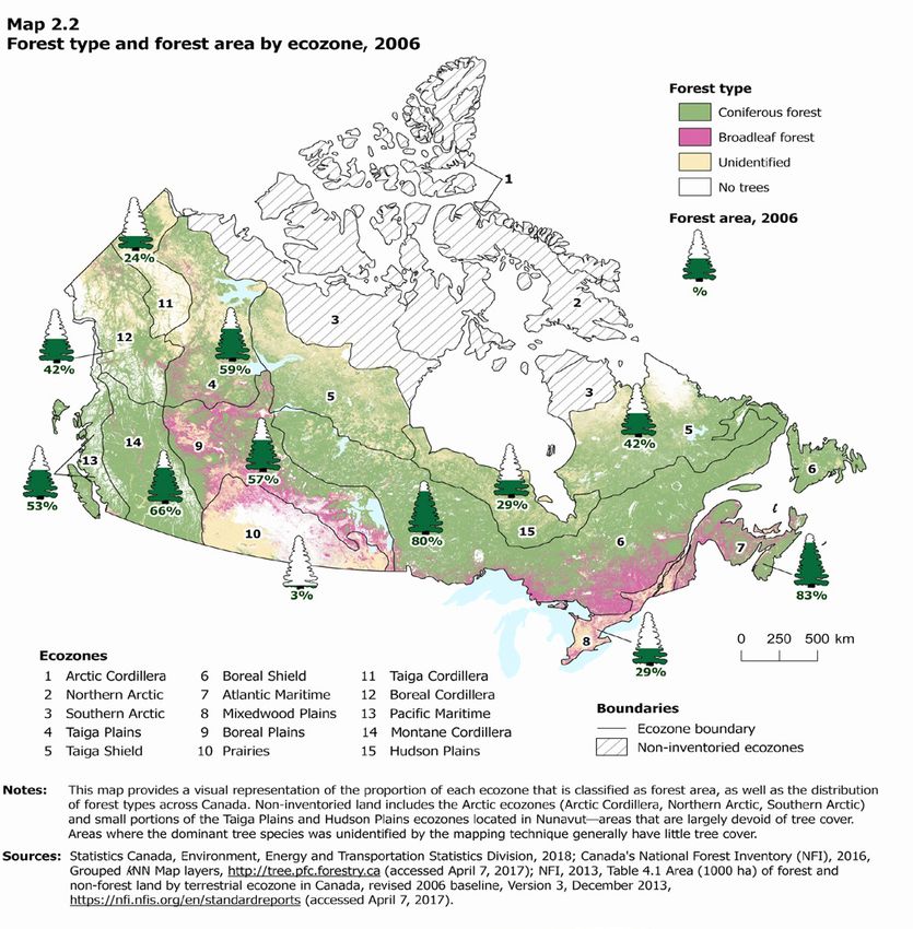
Coniferous species are dominant across ecozones in western Canada and across much of the boreal zone (Map 2.2).
The largest expanse of coniferous forest is found in the Boreal Shield with 788,790 km2, 60% of the ecozone’s forest
area (Chart 2.4). The Taiga Shield ranks second with 384,541 km2 (83%) and the Montane Cordillera ranks third
with 276,268 km2 (89%).
Broadleaf and mixedwood forests are more common throughout the Prairies, Mixedwood Plains and the Atlantic
Maritime, but also account for significant proportions of the Boreal Plains, Hudson Plains, and Boreal Shield ecozones.
The largest areas of mixedwood and broadleaf forest are found in the Boreal Shield with 436,923 km2 and the Boreal
Plains with 151,164 km2.
Spruce forests are the most common—they account for 53% of Canada’s forest area.17 Poplar is the second most
common species group, representing 11% of Canada’s forest, followed by pine at 10%.
17 Canada’s National Forest Inventory (NFI), 2013, Table 14.0 Area (1000 ha) of land by species group and age class in Canada, 2006 revised baseline, Version 3, December 2013, https://nfi.
nfis.org/en/standardreports (accessed April 7, 2017).
15 / Human Activity and the Environment 16-201-X — Statistics CanadaHuman Activity and the Environment 2017: Forests in Canada
Spruce trees are particularly characteristic of the boreal zone, with spruce–lichen forests providing important habitat
for caribou and other species.18 Spruce forests account for large proportions of forest area in the Taiga Cordillera
(89%), Hudson Plains (89%), Taiga Shield (86%) and Taiga Plains (85%).19 Poplar too are common in the boreal zone,
particularly in the Boreal Plains and Boreal Shield ecozones, where they represent 32% and 12% respectively of forest
area. The largest areas of pine forests occur in the Boreal Shield, Montane Cordillera and Boreal Plains ecozones.
Different species are seen to the south. In the Montane Cordillera ecozone, pines are the most common, accounting
for 34% of the forest area, followed by spruce (21%), fir (19%) and Douglas-fir (12%). Hemlock forests account
for 42% of the Pacific Maritime ecozone, followed by cedar (18%), fir (12%) and Douglas-fir (12%). Maple forests
account for 19% of the forest in the Atlantic Maritime and 39% of the Mixedwood Plains ecozones.
Chart 2.3
Forest type, 2006
Mixedwood, 16%
Broadleaf, 11%
Non-treed, 6%
Coniferous, 68%
Note: The category 'non-treed' includes areas that meet the criteria to be classified as forests, but that are temporarily unstocked with trees.
Source: Canada's National Forest Inventory, 2013, Table 5.0 Area (1000 ha) of forest land by forest type and age class in Canada, 2006 revised baseline, Version 3, December 2013,
https://nfi.nfis.org/en/standardreports (accessed April 7, 2017).
18 Federal, Provincial and Territorial Governments of Canada, 2010, Canadian Biodiversity: Ecosystem Status and Trends 2010, Canadian Councils of Resource Ministers, Ottawa, ON, p.17,
http://www.biodivcanada.ca/default.asp?lang=En&n=83A35E06-1 (accessed May 10, 2017).
19 Canada’s National Forest Inventory (NFI), 2013, Table 14.1 Area (1000 ha) of land by species group and age class and terrestrial ecozone in Canada, 2006 revised baseline, Version 3,
December 2013, https://nfi.nfis.org/en/standardreports (accessed April 7, 2017).
Statistics Canada — 16-201-X Human Activity and the Environment / 16Human Activity and the Environment 2017: Forests in Canada
Chart 2.4
Forest type by ecozone, 2006
Boreal Shield
Taiga Shield
Montane Cordillera
Taiga Plains
Boreal Plains
Boreal Cordillera
Pacific Maritime
Atlantic Maritime
Taiga Cordillera
Hudson Plains
Mixedwood Plains
Prairies
0 200,000 400,000 600,000 800,000 1,000,000 1,200,000 1,400,000
square kilometres
Coniferous Mixedwood Broadleaf Non-treed
Note: The category 'non-treed' includes areas that meet the criteria to be classified as forests, but that are temporarily unstocked with trees.
Sources: Canada's National Forest Inventory, 2013, Table 5.1 Area (1000 ha) of forest land by forest type and age class and terrestrial ecozone in Canada, 2006 revised baseline,
Version 3, December 2013, https://nfi.nfis.org/en/standardreports (accessed April 7, 2017).
17 / Human Activity and the Environment 16-201-X — Statistics CanadaHuman Activity and the Environment 2017: Forests in Canada Statistics Canada — 16-201-X Human Activity and the Environment / 18
Human Activity and the Environment 2017: Forests in Canada

Age class
Forests contain stands of trees of different ages. Stands are generally classified into different age classes based on the
dominant age of trees. Forests in many areas of Canada have gotten younger over time because of harvesting,20 while
some have gotten older due to fire suppression.21 Natural disturbance such as fires, insects, and windthrow create a
mosaic of stands of different ages in forests. Major stand-replacing fires allow for the establishment of young forests
and ecosystem-based forest management systems seek to emulate natural disturbances and the landscape patterns
of young and old stands that they create.22
As forests age, trees grow bigger and biomass increases, but forests also develop greater structural complexity and
biodiversity.23 For example, there may be more coarse woody debris, snags and fallen trees, while tree size, plant
and animal species may be more diverse.24 From the perspective of timber production, however, older forests are
less productive than young forests since growth rates slow as trees age and timber volumes decline as trees decay.25
The prevalence of older forests depends on the type of forest, since the biological life span of trees varies by species,
but also on the area, climate and fire regime. Most forest area—42%—is classed from 81 to 120 years old, followed
by 26% from 41 to 80 years and 12% under age 41 (Table 2.1). Forest areas that are classed older than 120 years
make up 14% of Canada’s forests. Broadleaf and mixedwood forests tend to be younger—and the oldest forests are
almost entirely coniferous.26
Most of Canada’s oldest forests are located in wetter areas of the west where the climate limits the frequency and
severity of fires. In the boreal zone, the prevalence of older forests depends on the climate and fire regime in different
areas. Fir, hemlock, spruce and cedar forests in the Montane Cordillera, Pacific Maritime and Boreal Cordillera
ecozones account for 95% of Canada’s oldest forests.27 In coastal rainforests, some hemlock, western red cedar and
yellow-cedar trees can reach over 1,500 years old.28

20 Federal, Provincial and Territorial Governments of Canada, 2010, Canadian Biodiversity: Ecosystem Status and Trends 2010, Canadian Councils of Resource Ministers, Ottawa, ON, p.17,
   http://www.biodivcanada.ca/default.asp?lang=En&n=83A35E06-1 (accessed May 10, 2017); Shorohova, E., et al., 2011, “Variability and dynamics of old-growth forests in the circumboreal
   zone: implications for conservation, restoration and management,” Silva Fennica, Vol. 45, no. 4, p. 785, http://www.metla.fi/silvafennica/full/sf45/sf455785.pdf (accessed June 21, 2017).
21 BC Market Outreach Network and Ministry of Sustainable Resource Management, 2003, British Columbia’s Forests: A Geographical Snapshot, p.14, https://www.for.gov.bc.ca/hfd/pubs/
   Docs/Mr/Mr112/ (accessed May 15, 2017); Shorohova, E. et al., 2011, “Variability and dynamics of old-growth forests in the circumboreal zone: implications for conservation, restoration
   and management,” Silva Fennica, Vol. 45, no. 4, p. 785, http://www.metla.fi/silvafennica/full/sf45/sf455785.pdf (accessed June 21, 2017).
22 Gauthier, S. et al., 2009, Ecosystem Management in the Boreal Forest, N. Lecompte (ed.), Les Presses de l’Université du Québec, Québec, http://chaireafd.uqat.ca/publication/articlePDF/
   RecettesDeDameNature_En.pdf (accessed October 16, 2017).
23 British Columbia, Ministry of Forests Research Program, 1998, “Seral stages across forested landscapes: relationships to biodiversity,” Extension Note, p. 1–8, https://www.for.gov.bc.ca/hfd/
   pubs/Docs/EN/EN18.pdf (accessed June 23, 2017); Federal, Provincial and Territorial Governments of Canada, 2010, Canadian Biodiversity: Ecosystem Status and Trends 2010, Canadian
   Councils of Resource Ministers, Ottawa, ON, p.17, http://www.biodivcanada.ca/default.asp?lang=En&n=83A35E06-1 (accessed May 10, 2017.
24 BC Market Outreach Network and Ministry of Sustainable Resource Management, 2003, British Columbia’s Forests: A Geographical Snapshot, p.14, https://www.for.gov.bc.ca/hfd/pubs/
   Docs/Mr/Mr112/ (accessed May 15, 2017).
25 Royal Commission on Forest Resources, 1975, Regulation of the Rate of Timber Harvesting in British Columbia, https://www.for.gov.bc.ca/hfd/library/documents/regulrate.pdf (accessed
   June 26, 2017).
26 Canada’s National Forest Inventory (NFI), 2013, Table 5.1 Area (1000 ha) of forest land by forest type, age class in Canada, 2006 revised baseline, Version 3, December 2013, https://nfi.
   nfis.org/en/standardreports (accessed April 7, 2017).
27 Canada’s National Forest Inventory (NFI), 2013, Table 14.1 Area (1000 ha) of forest land by forest type, age class and terrestrial ecozone in Canada, 2006 revised baseline, Version 3,
   December 2013, https://nfi.nfis.org/en/standardreports (accessed April 7, 2017).
28 BC Market Outreach Network and Ministry of Sustainable Resource Management, 2003, British Columbia’s Forests: A Geographical Snapshot, p.14, https://www.for.gov.bc.ca/hfd/pubs/
   Docs/Mr/Mr112/ (accessed May 15, 2017).

  19 / Human Activity and the Environment                                                                                                        16-201-X — Statistics Canada
Human Activity and the Environment 2017: Forests in Canada

Table 2.1
Forest area by age class and ecozone, 2006
                                    1 to 40            41 to 80           81 to 120           121 to 160        161 to 200          201 and over                  Other1                Total
                                                                                                     square kilometres
Canada                            428,634              913,416            1,453,208              266,121               62,551              149,874             201,953            3,475,757
Boreal Shield                     244,448              421,405              501,168               55,880                4,349                  101              85,395            1,312,747
Taiga Shield                        1,330               46,831              277,538               81,636                    0                    0              55,594              462,929
Boreal Plains                      48,482              178,361              108,717               22,339                5,018                  664              20,967              384,546
Taiga Plains                        3,593               53,778              264,247               12,014                1,197                  516                 667              336,012
Montane Cordillera                 20,895               41,708               73,041               64,887               36,253               62,208              12,292              311,285
Boreal Cordillera                  21,120               45,843               62,951               22,210               11,577               26,061               1,403              191,165
Atlantic Maritime                  60,672               76,970               16,679                  382                   17                    2               8,235              162,957
Pacific Maritime                    9,258               13,171                8,485                4,904                4,121               60,323               7,179              107,441
Hudson Plains                       1,062                2,395               85,401                  646                    0                    0               9,074               98,577
Taiga Cordillera                    6,581                8,540               48,193                1,097                   18                    0                   0               64,429
Mixedwood Plains                   11,157               17,186                2,380                  125                    0                    0                 845               31,692
Prairies                               37                7,228                4,411                    1                    0                    0                 302               11,978
1. Missing or unknown age class
Source: Canada’s National Forest Inventory, 2013, Table 5.1 Area (1000 ha) of forest land by forest type, age class in Canada, 2006 revised baseline, Version 3, December 2013, https://nfi.
nfis.org/en/standardreports (accessed April 7, 2017).

Timber volume
The amount or volume of wood present in a forest provides important information to inform decisions on forest
management and harvesting.29 The total standing timber volume in Canada is 47.3 billion m3, with one-third of this
total occurring in the Boreal Shield, followed by 17% in the Montane Cordillera (Table 2.2).
Timber volume depends in large part on growth rates, which vary according to the tree species, age and health and
on-site conditions including climate and access to light and nutrients.30 The fastest growing trees, as well as some of
the oldest trees, are found on the west coast. The Pacific Maritime ecozone has the highest timber volume per unit
area in the country—432 m3/ha—more than three times the national average of 136 m3/ha (Chart 2.5).
Coniferous forests account for 72% of timber volume, followed by mixedwood forests at 16% and broadleaf forests
at 12%.31 Spruce, pine and fir—the main species used to produce softwood lumber, make up almost two-thirds of
Canada’s total timber volume (Table 2.2).

29 Natural Resources Canada, Canadian Forest Service, 2016, The State of Canada’s Forests: Annual Report 2016, Ottawa, Catalogue no. Fo1-6E-PDF, p. 21, http://cfs.nrcan.gc.ca/pubwarehouse/
   pdfs/37265.pdf (accessed April 15, 2017).
30 Natural Resources Canada, Canadian Forest Service, 2016, The State of Canada’s Forests: Annual Report 2016, Ottawa, Catalogue no. Fo1-6E-PDF, p. 21, http://cfs.nrcan.gc.ca/pubwarehouse/
   pdfs/37265.pdf (accessed April 15, 2017).
31 Canada’s National Forest Inventory (NFI), 2013, Chart 15.0 Total tree volume (million m3) on forest land by forest type and age class in Canada, 2006 revised baseline, Version 3, December
   2013, https://nfi.nfis.org/en/standardreports (accessed April 7, 2017).

  Statistics Canada — 16-201-X                                                                                                Human Activity and the Environment / 20
Human Activity and the Environment 2017: Forests in Canada
Table 2.2
Standing timber volume by species group and ecozone, 2006
Spruce Poplar Pine Fir Hemlock Douglas-fir Birch Maple Others1 Total
million cubic metres
Canada 22,383 6,176 5,611 3,499 2,741 1,653 1,575 1,403 2,279 47,320
Boreal Shield 7,955 2,364 1,658 691 37 0 1,291 799 675 15,470
Montane Cordillera 1,970 216 2,486 1,359 413 1,016 34 0 322 7,815
Taiga Plains 4,306 775 77 0 0 0 38 0 5 5,201
Boreal Plains 2,226 2,112 711 19 0 0 34 1 77 5,180
Pacific Maritime 137 39 60 545 2,279 636 7 12 922 4,636
Taiga Shield 2,749 42 3 13 0 0 3 0 5 2,815
Boreal Cordillera 1,338 134 536 293 0 0 14 0 0 2,315
Atlantic Maritime 516 158 43 532 7 0 126 398 174 1,953
Taiga Cordillera 824 0 2 24 0 0 19 0 0 869
Mixedwood Plains 7 57 28 24 6 0 9 192 100 423
Hudson Plains 342 5 5 0 0 0 0 0 1 353
Prairies 12 276 1 0 0 0 0 0 0 290
1. Includes cedar and other conifers, larch, other hardwoods, unspecified conifers, unspecified hardwoods and unclassified trees.
Source: Canada’s National Forest Inventory, 2013, Table 16.1 Total tree volume (million m3) by species group, age class and terrestrial ecozone in Canada, 2006 revised baseline, Version 3,
December 2013, https://nfi.nfis.org/en/standardreports (accessed April 7, 2017).
Chart 2.5
Standing timber volume by ecozone, 2006
Pacific Maritime
Montane Cordillera
Prairies
Taiga Plains
Taiga Cordillera
Boreal Plains
Mixedwood Plains
Boreal Cordillera
Atlantic Maritime
Boreal Shield
Taiga Shield
Hudson Plains
Canada
0 50 100 150 200 250 300 350 400 450 500
cubic metres per hectare
Source: Canada's National Forest Inventory, 2013, Table 15.1 Total tree volume (million m³) on forest land by forest type, age class, and terrestrial ecozone in Canada and Table 5.1 Area
(1000 ha) of forest land by forest type, age class and terrestrial ecozone in Canada, 2006 revised baseline, Version 3, December 2013, https://nfi.nfis.org (accessed April 7, 2017).
21 / Human Activity and the Environment 16-201-X — Statistics CanadaYou can also read