Narcotrafficking and Land Control in Guatemala and Honduras
←
→
Page content transcription
If your browser does not render page correctly, please read the page content below
Tellman, B, et al. 2021. Narcotrafficking and Land Control in Guatemala and
                                               Honduras. Journal of Illicit Economies and Development, 3(1), pp. 132–159. DOI:
                                               https://doi.org/10.31389/jied.83

RESEARCH

Narcotrafficking and Land Control in Guatemala
and Honduras
Beth Tellman1, Kendra McSweeney2, Leah Manak3, Jennifer A. Devine4,
Steven Sesnie5, Erik Nielsen3 and Anayansi Dávila6
1
    University of Arizona, US
2
    The Ohio State University, US
3
    Northern Arizona University, US
4
    Texas State University, US
5
    Northern Arizona University and US Fish and Wildlife Service, US
6
    Anonymous, US
Corresponding author: Beth Tellman (btellman@arizona.edu)

On frontiers dominated by illicit activities such as narcotrafficking, criminal organizations’
usurpation of land and resources is profoundly changing rural livelihoods and prospects for
biodiversity conservation. Prior work has demonstrated how drug trafficking catalyzes forest
loss and smallholder dispossession but does not make clear the extent to which the long-term
control of land is moved from state, Indigenous, or smallholders to criminal or other actors. This
study attempts to describe those shifts. Specifically: we develop a typology of land control,
and use it to track how drug trafficking initiates shifts from public lands and Indigenous ter-
ritories to private large holdings. We examine an array of secondary sources indicating shifts
in land control related to narcotrafficking, including illegal land seizure documents, news media,
and surveys of land managers. In absence of formal land registries, frontier actors may signal
their control over land through land use change. After establishing where changes in land con-
trol have taken place, we analyzed land use and resulting changes in spatial patterns of forest
loss. We found that large scale sustained forest losses (over 713,244 ha and 417,329 ha), in
Guatemala and Honduras, respectively, from 2000–2019) corresponds with areas undergoing
shifts in control towards large landowners, often related to narcotrafficking. Incomplete empiri-
cal data on land control prevent comprehensive attribution of all sustained forest loss related
to narcotrafficking. Yet the limited evidence gathered here indicates drug trafficking activities
initiate widespread and sustained shifts and consolidation of who controls land and resources
at the frontier. Our work suggests that in Central America and likely elsewhere, control over
land—quite separate from property rights—is the key factor in understanding social and eco-
logical change.

Keywords: land control; narcotrafficking; Guatemala; Honduras; illicit frontiers

Introduction
Changes to land cover are visible from space and ever-easier to quantify in detail with satellite data. Changes
in land-use, the purpose to which land is employed, can be quantified by supplementing satellite data
analyses with social data or insights (Kugler et al. 2019). However, changes in land tenure, ownership, and
control—the ability to exclude others from access land and its resources—are social processes difficult to
detect at a distance, and thus remain poorly understood and unquantified across the globe (McSweeney &
Coomes 2020). Land system science has recently called for greater attention to land control as a key factor
in shaping land cover and resource use (Ashwood et al. 2020; McSweeney & Coomes 2020), and others have
noted the methodological challenges of ‘seeing’ land control using conventional approaches such as satellite
imagery analysis (Marinaro et al. 2020; Tellman, et al. 2020a). Others point to the difficulties of assessing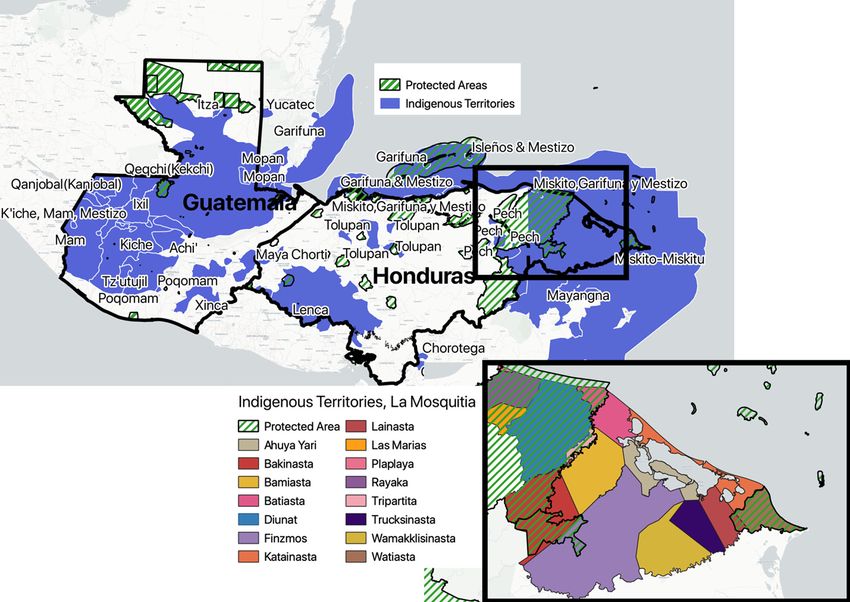
Tellman et al: Narcotrafficking and Land Control in Guatemala and Honduras                                 133

land control where land registries and cadasters are not publicly available, or are underfunded, corrupted,
or seldom updated—all of which render legal titles an inadequate representation of who controls land and
its use (Anseeuw & Baldinelli 2020).
   Understanding land control is particularly challenging in dynamic frontier landscapes dominated by forms
of criminal activity that simultaneously involve use, transformation, and investment in land (McSweeney et
al. 2017). In fact, drug traffickers are drawn to frontier landscapes, or those with relative land abundance
such as in Indigenous territories and protected areas, precisely because land tenure regimes are weak and
political authority or the rule of law is already in question (Ballvé 2018; McSweeney et al. 2017; PRISMA
2014). With this study, we examine how expanded drug trafficking networks lead to narco-driven change in
land ownership and control (hereafter, using the acronym NARC-LOC), and the implications of subsequent
land use changes for biodiversity conservation in Central America.
   Ample research has demonstrated that drug production and trafficking intensity over the last two decades
has changed land cover and land use in South and Central America. This region has long been a conduit for
South American cocaine heading to northern markets. Cocaine trafficking first spiked in the 1980s as DTOs
re-routed cocaine through Central American in response to interdiction in the Caribbean (Bunck & Fowler
2012). By the early 1990s, 15–25% of cocaine bound for the US passed through Central America (Brockett
2019). The volume of cocaine moving through Central America increased significantly again after 2000,
as traffickers responded to US-led drug war interdictions in Mexico (Bunck & Fowler 2012; Dudley 2011;
Unodc 2012). Today, an estimated 90% of cocaine destined for North America passes through the region
(United States Department of State Bureau for International Narcotics and Law and Affairs 2016). Cocaine
rents are increasingly captured by regional (e.g., Guatemalan and Honduran) criminal groups and part-time
narcotraffickers (known as transportistas) (not just Colombian and Mexican cartels, which dominated pre-
2005) (Blume 2021).
   The dynamic frontiers of northern Guatemala and eastern Honduras provide the remoteness, maritime
and border access, and weak governance systems that drug traffickers prize. The dynamic nature of drug
trafficking nodes (N. Magliocca et al. 2019), and the accumulation of excess illicit capital at these locations
generates at least five mechanisms that may lead to changes in land control and long-term land use tra-
jectories. Specifically, Drug Trafficking Organizations (DTOs) use land to launder illicit capital, move drugs
north (e.g., through clandestine airstrips), acquire land to establish territorial control for smuggling, con-
solidate land in agri-business landscapes, and enrich local elites operating in frontier regions who secure
land near trafficking nodes (Devine et al. 2020, 2018; McSweeney et al. 2017, 2018; Tellman et al. 2020a).
As a result, the intensity with which an area is enrolled in drug transshipment correlates with satellite
observed land cover changes, such as forest loss (Sesnie et al. 2017). However, drug trafficking does not
inevitably lead to land cover change, because traffickers also launder money in real estate and in mobile
assets (Maingot & Anthony 1988). While Central American forest loss is not only caused by narcotraffick-
ing, it is nevertheless a significant cause of forest loss, even when accounting for other factors (Tellman et
al. 2020b).
   There are thus well-established links between narcotrafficking and resulting land use and land cover
changes in Central America. But less is known about a key prior moment: just how, when, and where the
business of narcotrafficking creates shifts in land control. As researchers who have previously contributed
to understanding the links between drug trafficking and land cover change (Darién 2021; Devine et al.
2021; McSweeney et al. 2017; Wrathall et al. 2020), we realized that we had paid insufficient attention
to the underlying shifts in land control. Without clarifying land control dynamics, it became clear that
there was a gap in our understanding of the key process by which drug trafficking ultimately precipitates
land use change. Land control change is important to understand because it can lead to a larger array of
socio-environmental degradation beyond land use change, including illegal logging, wildlife trafficking,
declining conservation governance, economic inequality, and violence. Previous work estimated forest loss
patterns in protected areas (Sesnie et al. 2017; Wrathall et al. 2020), but did not comprehensively com-
pare land change patterns across the contested, changing, or informal land tenures or forms of owner-
ship, such as Indigenous territories or community concessions. This paper synthesizes novel data on land
controlled by narcotraffickers across nine disparate datasets identifying where and when narcotraffickers
built airstrips, developed agribusiness, and usurped land from smallholders, cooperatives, and the state.
While these data are insufficient to attribute every hectare of land controlled by narcotraffickers, it repre-
sents the most comprehensive attempt to spatialize evidence of land control by narcotraffickers on Central
America’s frontier.

134                                                    Tellman et al: Narcotrafficking and Land Control in Guatemala and Honduras

  The purpose of this paper is to identify how the intensification of narcotrafficking is changing the ways in
which land is controlled and its effect on land use change in Central America’s forested frontiers.1 Specifically,
we ask: i) in frontier economies increasingly dominated by narcotrafficking activities in Guatemala and
Honduras, what dominant shifts in land control have been observed? and, ii) As we see changes in land
control, use, and cover, what are the long-term implications for conservation management? We answer
these questions by linking spatio-temporal data on land control obtained by consolidating news media, land
seizures, assets of convicted narcotraffickers, clandestine airstrips, and surveys of members of land-based
NGOs to data on spatial rates of forest loss. After establishing where shifts in land control may be taking
place, we quantified where and when patterns of slow, dispersed forest loss are replaced by new patterns
of large, rapid clearings rates sustained over many years. In regions with established shifts in land control
towards large landowners, we assume actors with large amounts of capital are largely responsible for the
shifts towards rapid deforestation. While rapid deforestation and shifts in land control can be caused by
many factors, here we focus on change in land use and control associated with narcotrafficking. Results
estimate where narcotrafficking-related land control and land cover changes across tenure and property
regimes in Guatemala and Honduras.

Conceptual Framework of Land Control and Land Use Change
Defining Land Control
Land control is the sustained power to exclude others from accessing land and resources, and to deny oth-
ers’ mobility in and through a given space (Peluso & Lund 2011). Land control includes the power to draw
boundaries, restrict access (Ribot & Peluso 2003), and control points of entry and egress (Sikor & Lund
2009). Thus land control is the ability to exclude others from access, in contrast to property rights, defined
by the mere right to exclude others (Cole & Ostrom 2012). We define frontiers as an area with high perceived
land and resource abundance (relative to the rest of the country) and only partially enrolled in capitalist
social relations, i.e., it is considered by outsiders to be ‘underproductive’ and ‘undercapitalized.’ In frontier
landscapes where criminal actors wield authority, property rights often do not define land access. Official (or
de jure) rights differ from de facto processes typically legitimized by appeals to traditional norms or custom-
ary use-rights practiced on the ground. In frontiers, actors appeal to overlapping, contested, and constantly
changing forms of authority to legitimate rights and ensure land control (Cole & Ostrom 2012; Sikor & Lund
2010). The resulting ambiguities over who controls what in frontiers can be leveraged by new actors (here
we focus on narcotraffickers, and thus narco-frontiers) who challenge legitimate sources of authority over
land ownership (Hayes 2007).
   In the Central American narco-frontiers of Guatemala and Honduras, pre-existing property rights are pro-
foundly impacted and overwhelmed by the influx of money and violence associated with drug trafficking
(McSweeney et al. 2017). This happens because traffickers use their financial and physical power to destroy
or co-opt pre-existing sources of legitimate authority over property rights and land control. For example,
traffickers can force Indigenous peoples to ‘sell’ communal lands, undermining the authority of traditional
land regimes. The fact that Indigenous lands are formally inalienable does not matter; narcos routinely co-
opt state authority by bribing political officials into legitimizing stolen land through fraudulent land titles
(McSweeney et al. 2018). In effect, they create a new source of authority for asserting control over land and
resources—one based not on law or precedent but on violence, financial coercion, and state cooptation lead-
ing to impunity. While wholly illegitimate and illegal it is no less authoritative (Wrathall et al. 2020).
   Distinguishing land ownership from land control is essential in narco-frontiers, where the drug trade
contests the rule of law, reshapes political authority, and injects economic relations with illicit capital and
violence (Ballvé 2018, 2012). However, narco-frontiers are hardly unique as landscapes in which land control
is distinct from ownership. In South African National Parks, for example, state actors have achieved control
over de jure private conservation lands in Mozambique (Massé & Lunstrum 2016). Commodity crop booms
from Southeast Asia to Guatemala precipitate elite and corporate control of land that is officially held by
communities (Alonso-Fradejas 2012; Hall 2011). New urban residents in informally urbanized settlements
across Latin America frequently control urban parcels despite not holding legal title (Salazar 2012; Tellman
et al. 2021). Sometimes land control leads to changes in de jure land ownership. In Colombia, violent land

 1
     We define frontier as an area that relative to the rest of the country has relatively high perceived land and resource abundance, and
     is only partially enrolled in capitalist social relations, i.e., it is considered by outsiders to be ‘underproductive’ and ‘undercapitalized.’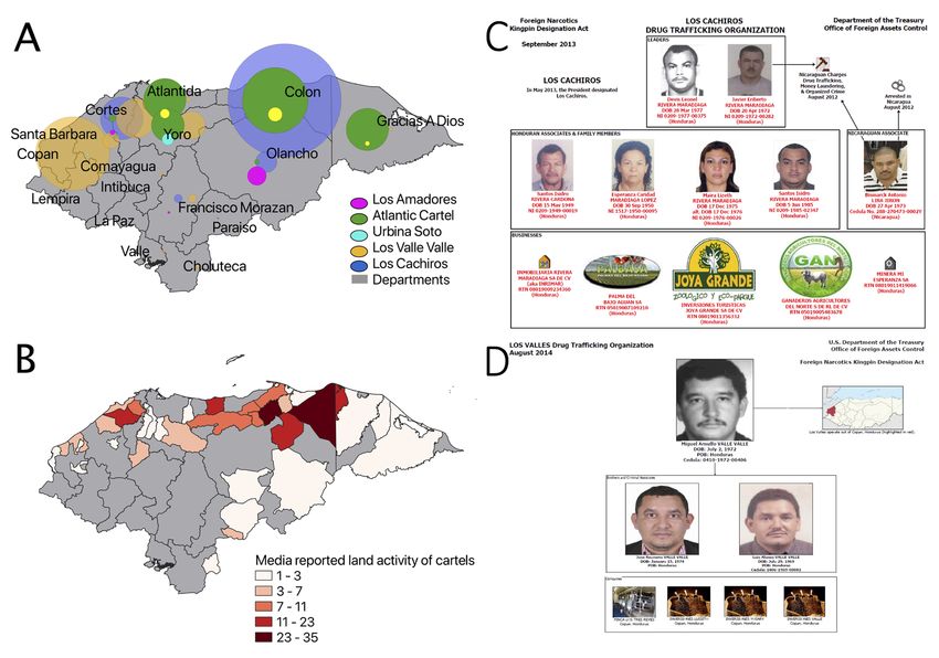
Tellman et al: Narcotrafficking and Land Control in Guatemala and Honduras                                   135

grabs first involve control of land by criminals, and sometimes, subsequent legalization of their rights to that
land (Grajales 2015).
   Shifting land control can lead to material changes in land use and land cover, often with negative con-
sequences for smallholders’ rights and Indigenous peoples’ sovereignty, territorial futures, inequality, rural
livelihoods, food security (Tamariz 2020), biodiversity conservation, ecosystem services (Ceddia 2019) and
Indigenous women’s security (Hernández Castillo 2019). For example, changes in who controls access to the
Colombian forest after the Peace Accords—absent any changes in ownership per se, transformed patterns of
land use and accelerated deforestation in and around protected areas (Clerici et al. 2020; Murillo-Sandoval
et al. 2020) and continued violent displacement of Indigenous peoples (‘Guerra en el paraíso,’ 2020).
Understanding changes in land control can predict where land use will, or already has, changed.

Land Control Change Scenarios
Land control is shaped by actors with different levels of power in an ‘action arena’, defined as the space
encompassing the role of actors, their sets of choices, access to information, and control over the rules of
land access (Figure 1). Powerful actors use their ability to exclude to exercise control through political,
economic, or social capital, or violence (Knight 1992; Tellman et al. 2021). In illicit land transactions, or
exchanges that are intentionally hidden because they violate legal rules or social norms, violence, intimi-
dation or bribes to politicians are often used to enforce the ability to exclude. There may be a large power
differential between who previously controlled land in time 1 and who becomes the new ‘controller’ in time
2 (Tellman et al. 2020a).
   Changes in land control may lead to changes in land cover and land use. When control by actors is main-
tained, land cover change is steady outside of exogenous factors (market shifts, climatic change, environ-
mental change, or others) (Lambin et al. 2001; Meyfroidt et al. 2018). However, since land cover is observable
by satellite (and land control is not), large shifts in land cover patterns can be used to infer when a change in
control has occurred between two time periods. For example, accelerated land change can indicate a shift in
control from type I to a new arrangement of actors in power in a new control type II (e.g., deforestation with
new foreign actors in Indonesian palm oil markets) (Hall 2011). Decelerated land change can also indicate
a change in control, for example, when a military group, such as the FARC in Colombia, controls a forested
region and prevents access (see Murillo-Sandoval 2020).
   We use the simplified framework in Figure 1 to identify potential land control transitions and quantify
their land use outcomes, or how change in control type I shifts to new types in Central America’s narco-fron-
tiers. Control types include commonly held to private forms of ownership, formal state control to territories
controlled by criminal groups, local to extra-local actor control with net dispossession of residents, or other

Figure 1: Hypothetical land control and change scenarios. T1 = time period one, and T2 = time period two
  at a specified later point in time. When control is maintained, and the actors with different levels of power
  (size of black dots), in the action area are constant, land change remains relatively constant (same rate,
  pattern of change). When control changes from type I to type II or III at time 2 (T2), and the action arena
  shifts who controls land, change might accelerate or decelerate. Changing land uses can feedback into the
  action arena, influencing who controls land and new land patterns emerge.
136                                           Tellman et al: Narcotrafficking and Land Control in Guatemala and Honduras

combinations (see land control types column in Table 1). Changes in control do not always lead to change
in land use outcomes, likewise rapid shift in land cover patterns are not always an indicator of changes in
control (e.g., fire regimes, hurricane damage, and other environmental hazards can drastically change land
cover). Understanding if, where, and how, land changes signals a shift in control requires linking known

Table 1: Forms of land control in Central America across commonly held, state owned, and privately held
  land.

 Ownership type       Land control       Land access           Principle sources of           Spatio-temporal
                      type               controlled by         authority(1)                   attributes signaling
                                                                                              effective land control
 Commons              Indigenous         Indigenous com-       Use precedent (ancestral       Clustered settlements sur-
                      lands              munities              history), moral claims, cus-   rounded by dynamic patch
                                                               tomary law; state recogni-     mosaic of small agricultural
                                                               tion; collective titles        plots and forest, typically
                                                                                              organized along bodies of
                                                                                              water*
                      Forestry or        Campesino             State via land reform laws;    Clustered settlements
                      agricultural       organizations or      moral claims                   surrounded by defined/
                      concessions        communities                                          fixed parcels dominated
                                                                                              by mixed-use agriculture,
                                                                                              organized along state-sup-
                                                                                              ported road infrastructure

 State/Public         Heritage or        State actors (e.g.,   State and international        Dominance of forest or
                      conservation       forestry service);    biodiversity or heritage       other relatively undisturbed
                      set-asides         citizen brigades      preservation commit-           land covers (e.g., open
                                                               ments; military might          pine savannah). Absence
                                                                                              of sustained recent human
                                                                                              activity, enforced borders
                      National Lands     State actors          State, land ministries, for-   Lands that have not
                                                               estry concessions, political   been titled, developed or
                                                               power                          ‘improved’, e.g., baldíos,
                                                                                              (see Kneas 2020).

 Private              Smallholder,       Individuals or        Moral authority; state-        Bounded clearings with
                      resident           families              sanctioned legal title; land   low or temporary pace
                                                               reform decrees; use prec-      of expansion (varies by
                                                               edent (settlement history);    region), typically emerging
                                                               other forms of power (e.g.,    along roads or waterways;
                                                               patronage by powerful          scattered homesteads;
                                                               private actors; threat of      fences; smaller cattle
                                                               violence).                     ranches
                      Large holder,      Individuals or        Legal property titles,         Bounded clearings with
                      resident           families; employ-     whether legitimate or          rapid or sustained pace of
                                         ees                   fraudulent; use or threat      expansion (varies by region)
                                                               of violence; external          can be near or distant from
                                                               patronage relationships        infrastructure; fences and
                                                               with political, business, or   permanent establishment
                                                               military elites                of pasture or plantation
                      Absentee           Employees of          Property titles, whether       Sustained presence of large
                                         individuals or        legitimate or fraudulent;      clearings over 5 ha annu-
                                         corporations          use or threat of violence;     ally; productive uses may be
                                                               external patronage rela-       hard to detect; pasture or
                                                               tionships with political,      plantations may be present
                                                               business, or military elites

(3) For discussion of sources of authority: see Sikor and Lund (2009).
* Mainly applies in Honduras and Nicaragua.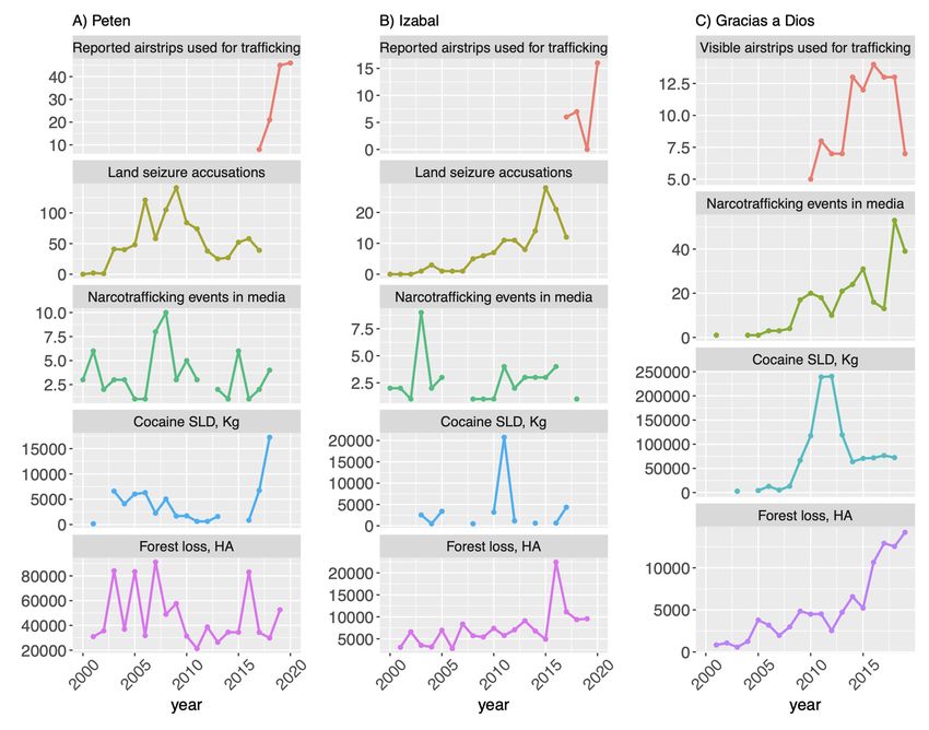
Tellman et al: Narcotrafficking and Land Control in Guatemala and Honduras                                  137

or underlying land use process to observed spatial patterns (known as ‘socializing the pixel’ in land system
science) (Tellman et al. 2020a).

Land Use Patterns and Control Types Influenced by Narcotrafficking in
Guatemala and Honduras
Typologies of Land Control
We summarize the most common types of land control and their spatial patterns in Central America
in Table 1, followed by a description of how these types emerged and influence narcotrafficking land
control dynamics (post 2000). The table disaggregates standard categories of property ownership
(commons/public/private) into specific control types, who controls it, by what the authority, and its typi-
cal land cover/land use pattern. Land control types describes de facto land access which may not equate to
de jure property rights. For example, persistent smallholder inholdings within the borders of a biosphere
reserve represent an instance of effective private land control, in which settlers have demonstrated the
power to exclude others who might displace them (e.g., Hayes 2007). Land control by smallholders on
state land may be legitimized by appeals to morality—that is, the right of the poor to use available land
or to maintain inholdings preceding protected area designations. In contrast, large holder resident or
absentee land control may achieve legal ownership, especially when legal title increases the speculative
value of land (Gilbert 2002). Ascribing specific actors to land control types, however, is challenging (cf. le
Polain de Waroux et al. 2018). While drug trafficking catalyzes changes in land control, outsider ‘narcos’
do not necessarily come to control all lands changed under a narco-regime. The social complexity of these
regimes makes distinctions between ‘narcos’ versus Indigenous peoples or others untenable (McSweeney
et al. 2018). Emergent land control types and authority, and change trajectories are rooted in Guatemalan
and Honduran land history that pre-date increased drug trafficking intensity.

Histories of Frontier Change in Guatemala and Honduras
The shared histories of agrarian reform, colonization, conservation, and neo-liberal structural adjustment
define Guatemalan and Honduran frontier landscapes, and render them susceptible to NARC-LOC (narco-
driven change in land ownership and control). The two dominant NARC-LOC dynamics include: 1) direct
control over protected areas for territorial operations such as roads and clandestine landing strips, border
crossings and money laundering, and 2) trafficking operations and money laundering embedding in private
lands (territorial control and cattle ranching) at different times leading to land consolidation and dislocation
of capitalized peasants and ranchers further into the forest frontier. These two dynamics precipitate a shift
in control from vulnerable conservation set-asides, concessions, and smallholder residents to large holdings
held by local elites or absentee owners. Below, we describe key moments in the history of the countries’ fron-
tiers, and the acceleration of land control changes as drug-traffickers increasingly operated in the region.
   During the 1950s–1980s, public national lands were transferred to private smallholder residents or com-
monly held land in forest/agricultural concessions. Agrarian and counter agrarian reforms in rural and
forested landscapes of Guatemala and Honduras set in motion dynamics of peasant colonization that legiti-
mized de facto land control as means of acquiring formal land rights. State agencies identified forest and
scarcely populated rural areas as escape valves for agrarian pressures elsewhere, creating national imaginar-
ies of these frontiers as spaces ripe for colonization. In Guatemala, decades of state-sponsored coloniza-
tion created a national imaginary of the Petén department as an unpopulated space with available land
that endures today (Grandia 2012; Schwartz 1990). In Honduras, agricultural valleys along the frontier in
Olancho and Colón departments were targeted for agrarian reform that promoted the occupation of idle
public lands considered ‘baldios’ (empty or vacant spaces) and redistributed them to peasant organizations
under usufructuary rights (dominio util) (Nelson 2003). In both countries these efforts established informal
land occupation and control as mechanisms for formalizing ownership—creating the occupy-then-title prac-
tice defining NARC-LOC today.
   Heritage or conservation set asides emerged as a key land conservation strategy and form of land control
in Guatemala and Honduras in the 1980s and 1990s. Protected areas (PA) were delineated to conserve
relatively intact forest and advance sustainable rural development and biodiversity conservation on state
owned lands. During Guatemala’s peace process (1985–1996), the state created the National System of
Protected Areas in 1989, and the 22,000 km2 Maya Biosphere Reserve (MBR) in 1990 in the Petén. In 1991,
the Honduras state created the Department of Protected Areas and Wildlife, and within a few years estab-
lished 22 national parks and two biosphere reserves, including the Tawahka-Asagni and expansion of the Río
Plátano in eastern Honduras. These PAs include zoning schemes that allow for non-consumptive uses in core
138                                                 Tellman et al: Narcotrafficking and Land Control in Guatemala and Honduras

zones, regulated sustainable uses in buffer zones where private property and cattle ranching are permitted,
and mixed use or cultural zones that recognize existing Indigenous settlements and permit sustainable land
uses (Herlihy 1997; Nations 2006).
  Unfortunately, the creation of protected areas occurred alongside neo-liberal austerity programs in
Guatemala and Honduras that resulted in insufficient funding and understaffing of state agencies charged
with their stewardship (Bovarnick et al. 2010). These structural adjustment policies undermined the ability
of state agencies to control PA access, creating ‘paper parks’ without mechanisms for land control or law
enforcement. Nowhere is the paper parks phenomenon more evident than in the frontier regions of north-
ern Guatemala and eastern Honduras. Lack of institutional control and the presence of illicit logging, road
building, and illegal settlements led to UNESCO placing the Río Plátano on the list of World Heritage Sites
in Danger in 1996 (UNESCO 1996).
  In some cases, public heritage or conservation set asides shifted to commonly held land in forest conces-
sions. In mixed use and buffer zones, community forestry concessions represent a unique conservation strat-
egy whereby communities receive long term leases on public lands embedded in protected areas to engage
in productive forest enterprises under a state approved management plan (Del Gatto 2013; Nations 2006).
Guatemala’s MBR concessions are a global success story and demonstrate that with financial investment,
high social capital, and strong state support, community forest concessions are capable of exerting control
and reducing deforestation in comparison to non-concession forests (Blackman 2015; Del Gatto 2013).
  Neo-liberal market-assisted land reform (MALR) in the 1990s–present has shifted land control from public
lands, concessions, and smallholder residents to large holder residents and even absentee landowners. In
Guatemala, the national imaginary of the Petén combined with the failure of MALR, drove landless and land
poor peasants to the Petén and into the MBR. Poverty, debt, and the poor quality of program lands resulted
in many ‘beneficiaries’ selling their lands and moving north to seek alternatives (Alonso-Fradejas 2012). In
Honduras, the neo-liberal Agricultural Modernization Law (AML) (1992) allowed for the sale of agrarian
reform lands and the titling of up to 200 hectares of national or public lands that had not been defor-
ested (AML 1992). These dynamics led to a new round of land consolidated by large cattle and african palm
land owners and displaced smallholder beneficiaries of land reform deeper into the frontier forests (Herlihy
1997; Stonich 1993; Sunderlin & Rodriguez 1996).
  Neo-liberal market-assisted land reform in Honduras also shifted control from public land toward com-
monly held Indigenous lands due to significant Indigenous political mobilization to include Indigenous pro-
tections and provisions in the 2004 Property Law and the 2007 Forestry Law. In response, the World Bank’s
Land Administration Program titled 14 Indigenous territories encompassing 1.5 M hectares in Gracias a
Dios (Galeana & Pantoja 2013; Herlihy & Tappan 2019). These titles are legally indivisible, indefeasible, inal-
ienable and imprescriptible (ICF 2016). However, in the absence of social control, collective management
capacities and state support, Indigenous territorial councils have struggled to exclude narcotraffickers and
other colonists (Hale 2011; Larson et al. 2013; McSweeney et al. 2017; PRISMA 2014).

Frontier Change Under Accelerated Drug Trafficking (> ca. 2000)
The intensification of drug trafficking through Guatemala and Honduras in the 2000s (see UNODC 2012;
Brockett 2019) had a variety of impacts on their land control trajectories.
  First, remoteness and weak enforcement in National Parks over time has left them vulnerable to control
change enacted by narcotraffickers, or as Guatemalan conservation officers describe them, as ‘ungovernable’
(Wrathall et al. 2020). For example, the isolated MBR shares 50% of Guatemala’s border with Mexico, and its
largest national park, Laguna del Tigre, was declared a ‘Narco’s Paradise’ in 2004 by the national press. This
moniker was given due to the hundreds of clandestine airstrips dotting the park, and the impunity charac-
terizing cartel trafficking activities, illegal land grabs, and territorial occupation (‘Laguna del Tigre, tierra sin
ley,’ 2004). Smallholder residents practicing subsistence agriculture in national parks such as Laguna del
Tigre have been displaced by narcotraffickers directly, or indirectly through state eviction claiming commu-
nities work with narcotraffickers, which may not be true (Lunstrum & Ybarra 2018).
  Second, narcotrafficking has also caused a shift in control from concessionaires (residents who manage the
concession) to absentee landowners in several cases. Narcotrafficking activity has been linked to canceled or
indefinitely suspended concessions in Guatemala’s Petén (La Pasadita, San Miguel, La Colorada).2 In Cruce a

  2
      The factors leading to concession cancellation are nuanced at the level of the individual concessions. San Miguel la Palotada, for
      example, failed due to the concession’s small size, lack of commercial forest products, and mismanagement, alongside narco-traf-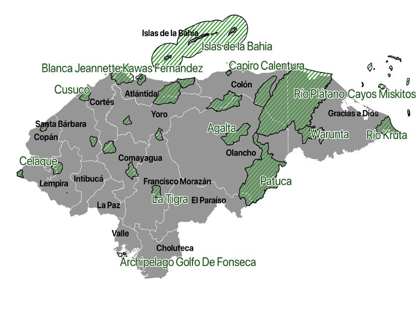
Tellman et al: Narcotrafficking and Land Control in Guatemala and Honduras                                                         139

la Colorada, the concession was nearly canceled after narco-ranchers cleared forest. Narco-ranchers assassi-
nated the concession leader, David Salguero, who filed a land seizure complaint to Guatemala’s Commission
on National Protected Areas (CONAP) (see Devine et al. 2020).
   Finally, narco-traffickers have also benefited from market-assisted land reforms. In Guatemala, for exam-
ple, ten members of the Mendoza trafficking cartel used economic coercion and violence to acquire 28
farms using testaferros, or frontmen, to launder US $3.2 million through land sales and oil palm production
(CICIG 2019). In Olancho, Honduras, DTOs extended clandestine roads towards the Nicaraguan border and
laundered money through cattle ranching (‘Asequeran mas propiedad de “Los Cachiros” en Olancho,’ 2015),
meat processing (Mackey 2017) and logging operations (Avalos 2020). These investments led to a consolida-
tion of control over private lands, the displacement of cattle ranchers into the forest frontier, and opened
up new settler access to protected area lands; cattle ranching is a preferred means of money laundering and
establishing territorial control for DTOs (Devine et al. 2020, McSweeney et al. 2017). ‘Narco-cattle ranchers’
in Guatemala in the MBR pay peasants meager wages to clear forests or savannahs to plant pasture and ranch
cattle, while land speculators of means clear areas near the Mexican border in hopes of selling the ‘improved’
lands to ranchers (Devine et al. 2020). Further, land titling in indigenous territories has also been under-
mined by narcotrafficking, who can increase land consolidation for absentee owners as they seize on unsure
or contested tenure and property relations to seize more land (PRISMA 2014). In the case of Honduras, the
state’s recent granting of territorial rights to indigenous Miskitu is a triumph in theory. In practice, the weak
and narco-corrupted state cannot support Miskitu efforts to enforce those rights, and the invasion of narco-
enriched outsiders into Miskitu territory has even accelerated since (Galeana 2020; Rayo 2021).

Materials and Methods
Our approach is based on the conceptual framework presented in Figure 1. Our first challenge was to
empirically demonstrate when and where narcotrafficking catalyzed shifts in land control. We were greatly
aided in this respect by a US government dataset that reliably tracks where and when cocaine is delivered
into Central America (see ‘drug flows,’ below). But while we could track the location and popularity of drug
trafficking hubs, we needed a different approach for analytically linking those trafficking activities to spe-
cific sites in which narcos were asserting their control over land. This was difficult for obvious reasons:
criminals do not typically seek to make visible the ways in which they acquire, hold, and accumulate land.
We therefore turned to a multi-method approach that involved gathering nine different forms of evidence
of narco-holdings, including public records, news media, in-situ knowledge based on our prior fieldwork,
and a survey of land managers in specific conservation areas. Each data source is limited in unique ways,
but in combination tell a compelling and fairly coherent picture of the extent and nature of drug traffickers’
control over land. We discuss the sources we used for Guatemala and Honduras, respectively, below.
   Our second challenge was to relate those changes in land control to conservation-relevant changes in land
cover/land use, specifically in terms of forest loss. We therefore estimate annual forest loss rates of large
and rapid, consolidated versus slower, dispersed land clearing for three land ownership types (commons,
public, and private from Table 1). To assess when and where land control type change (e.g., from type I to
type II) lead to a change in land outcomes, we compare annual graphs and maps of land control and spatial
rates of land change at the department and municipal scales. We describe this process in detail at the end
of this section.

Data on Drug Flows
Our analysis of the spatial-temporal dynamics of drug trafficking intensity relies on two sources, official
records and news media reports (Table 2). The official data relies on the CCDB (Consolidated Counterdrug
Database), widely recognized to be the authoritative official data on cocaine flows seized by law enforce-
ment, lost (not delivered to its intended location), or delivered (see McSweeney 2020, for a detailed descrip-
tion). However, CCDB is not available for all departments in Central America, and have a known bias of
delayed recording of narcotrafficking intensity increases of up to several years, depending on the country
(Tellman et al. 2020b). We supplement drug flow data with media reported events of narcotrafficking, which
are spatially complete across Central America and more temporally accurate (see Tellman et al. 2020b, for a
detailed description).

   ficking and narco-cattle ranching activities. In La Pasadita, La Colorada, and Cruce a la Colorada, narco land grabs and narco-cattle
   ranching played a clear, more prominent role in cancellation (Devine et al. 2020, 2018).
140 Tellman et al: Narcotrafficking and Land Control in Guatemala and Honduras
Table 2: Data on drug flows in Central America.
Variable Description Temporal Scale, Source
Resolution, Unit
Drug trafficking Cocaine seized, lost or, delivered as 2000–2018, 11 depart- Consolidated Counter
and seizure data tracked by US military ments, kilos of cocaine, Drug Database (CCDB)
Media events Media reports with department specific 2000–2019, 2,551 events Coded newspaper articles
narcotrafficking activity events at department scale, from major media outlets
n = 1,901 Honduras and (Tellman et al. 2020b)
n = 650 in Guatemala
Table 3: Data on Guatemala land control by narcotraffickers 2000–2020 from various sources.
Data Explanation Sample size Temporal Scale, Source
Resolution, Unit
Land seizures in Accusations registered by the 1,190 accusa- 2000–2017, annual, Public ministry,
protected areas, Guatemala government of illegal tions Guatemalan Guatemala
Guatemala land seizures in protected areas municipalities, crimes
Cartel land holdings, Georeferenced private land hold- 80 polygons 2004–2011, Petén, Insight Crime
Petén ing linked to identified cartels in over 100,000 Guatemala, land (2011)
legal land registries. ha parcels
Clandestine airstrips Number of clandestine and 217 airstrips 2017–2020, annual, Guatemalan
illegal airstrips identified by the Guatemalan Military
Guatemalan government departments
Land seized of Land seized from Mendoza Cartel, 30 locations, 2016, Petén, CICIG (2016)
Mendoza Cartel who forced peasants to abandon over 30,000 Guatemala, list of
land and re-register land titles for hectares seizures
the Mendoza DTO members
Canceled forest com- Two community forest conces- 3 conces- 2009, Petén, Ethnography
munity concessions sions that were canceled due to sions Guatemala, (Devine et al.
land grabs and deforestation by concession area 2020)
narcotraffickers
Narcotrafficking Land Control Data for Guatemala
The presence of drug trafficking influenced land control was established in five ways (Table 3).
(1) Land held by organized crime was identified via registered private lands under names of DTO mem-
bers identified in a 2011 anonymous report published by InSight Crime (2011); we digitized and
georeferenced these data.
(2) Thirty farms controlled by DTOs were identified by the International Commission against Impu-
nity in Guatemala (CICIG). One DTO forced peasants to abandon their parcels, which were retitled
to DTO members in the Guatemalan National Property Register. While the exact polygons of the
properties were not available, the total area by municipality and land use were reported, which we
digitized and collated.
(3) Reports of illegal land seizures were obtained by request to the Public Ministry under
Guatemalan Transparency of Information Laws. The reported timing, and area of seizures was
summarized by location and year. These data represent accusations of ‘usurpación’ or illegal land
seizures or grabs in protected areas; some of these holdings were corroborated as narco-owned
through interviews with the Guatemalan National Commission of Protected Areas (CONAP)
(Supplementary Table 1).
(4) Clandestine airstrips are built by traffickers to move product, some of which are recorded in the
Guatemalan military’s records of unauthorized airstrips. The data were obtained by freedom of
information request in June 2020 by the authors.
(5) In three community concessions, traffickers cut forest and established cattle ranches. The conces-
sions were canceled as a result in 2009.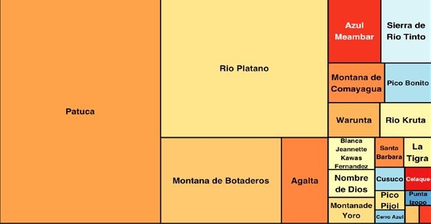
Tellman et al: Narcotrafficking and Land Control in Guatemala and Honduras 141
Narcotrafficking Land Control Data for Honduras
Data on land control by narcotrafficking specific to Honduras were collected in four ways (Table 4).
(1) Landed assets from narcotraffickers were identified through the Foreign Narcotics Kingpin Designa-
tion Act (Office of Foregin Assets Control 2014). We searched the list of Kingpins (US Department
of Treasury 2020) for DTOs. We found no rural landed assets in Guatemala, but in Honduras, three
organizations (Los Cachiros, Los Rosenthals, and Los Valle Valle) and recorded the business type and
location of each for the 13 assets mentioned.
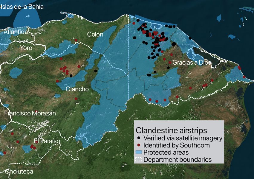
(2) Clandestine airstrip data in Honduras include data from the Honduran military in interdiction ef-
forts called ‘Operation Armadillo’ in 2012 and those identified by authors in Honduras via Landsat
Satellite imagery in Google Timelapse and high spatial resolution imagery from WorldView-2 ac-
cessed via the Digital Globe (www.digitalglobe.com/products/enhanced view- web-hosting) from
2010–2020. Of the 169 airstrips identified, 140 have been visibly decommissioned (e.g., temporarily
disrupted or bombed) during interdiction efforts. Identified airstrips are not connected to munici-
pal airports or official roads. The year each airstrip was built was estimated via satellite data. These
data likely underestimate the number of airstrips because strips established on pasture and other
agricultural lands can evade detection.
(3) News media articles identify where landed property was seized from DTOs and where they operated
(n = 1,966 at department scale and n = 919 at municipal scales). Geographic coordinates derived
from these media sources where then mapped, yielding 659 articles within 15km of protected area
boundaries.
(4) To understand how narcotrafficking influenced land control, we rely on a 2020 survey of 144 NGOs
working in sustainable development. Using purposive chain-referral sampling, we first called 42
randomly selected organizations from the initial list of 144 NGOs. A total of 17 were interviewed.
All interviews with managers were recorded, transcribed, and analyzed using NVivo 10 qualitative
data analysis software (‘NVivo,’ 2014) through systematic theming and categorization. Two ques-
tions were asked: ‘How has your organization been affected by the presence of illegal activities?’
and ‘How has your organization responded or adapted to these activities?’ Preliminary themes il-
lustrated types of illicit resource-based activities in the locations where NGOs reported working, and
how the organization has responded to these activities. These themes were utilized to develop the
online questionnaire and provide contextual richness for interpreting survey results.
Table 4: Data on Honduras land control by narcotraffickers 2000–2017 from various sources.
Data Explanation Sample size Temporal Scale, Source
Resolution, Unit
Cartel territo- Media reports with department 1,206 events, 2000–2019, annual, Coded newspaper
rial control specific narcotrafficking activity 283 with named Honduran munici- articles from
reported by events related to land and named cartels, 659 in palities, events major media
media cartels and within 15km of a protected areas outlets
protected area
Perceptions Survey participants’ valuation 82 survey par- 2020, Honduran Survey and
of the effects of how severe the effect of illicit ticipants and 17 Departments, inter- interviews
of illicitness, resource-based activities is on interviewees viewee/respondent with 144 non-
survey data their organization’s efforts in governmental
conservation and sustainable organizations
development initiatives.
Clandestine Location of clandestine airstrips 196 airstrips 2017–2020, annual, Operación
airstrips related to narcotrafficking identi- coordinates Armadillo, World-
fied by US & Honduran govern- view-2, US army
ments and research team southcom.
Kingpin Assets seized by US treasury 11 assets from 2002–2020, assets Office of Foreign
under the Foreign Narcotics 3 cartels in are reported as Assets Control,
Kingpin Designation Act Honduras legally registered (US Department
(Rosenthals, business for each of Treasury, 2020)
Valle Valle, and cartel and country
los Cachiros)142 Tellman et al: Narcotrafficking and Land Control in Guatemala and Honduras
For the subsequent online questionnaire, we identified 392 emails of employees working for the 144 NGOs
identified in Honduran directories from 26 municipalities (in 12 departments), yielding 82 complete responses.
The online Spanish survey focused on participants’ assessment of how illicit activities (including wildlife poach-
ing, violence, and narcotrafficking) influenced conservation and sustainable development initiatives. The online
survey asked respondents to indicate the degree to which (on a 1–4 Likert scale) illegal activities influence 17
challenges (including governance, economic, and land dimensions) related to the success of their organization.
We followed Dillman, Smyth and Christian (2014) for enhancing response rates for internet surveys.
Interview and survey questions and methods, including participant consent forms were approved by
NAU’s IRB (#1466302-3). Due to the sensitive nature of the topic, the survey was targeted at organizational
experiences and not individual experiences. The cover letter attempted to establish the credentials of the
research team and make it clear that responses would be anonymous, confidential, and that no identifying
information would be requested in the survey. A response rate (29%) prompted a non-response bias check
based on the type of organizational conservation or sustainable development work associated with the
NGOs in our initial list versus those that responded. We found similar percentages of each in our responses.
Additionally, we assessed the geographic areas of work for each NGO participant invited to participate and
found no bias in geographic representation.
Data on Forest Loss and Land Ownership
Data on forest loss and land ownership are summarized in Table 5. To measure forest loss we used annual,
spatially explicit, high resolution (30 m grid cells), and validated forest loss data consistent over the Central
American region, obtained from the University of Maryland Department of Geographical Sciences Global
Forest Change version 1.7 (see: https://earthenginepartners.appspot.com/science-2013-global-forest/
download_v1.7.html accessed 10/8/2020) (Hansen et al. 2013). Continuous forest patches measuring ≤2
ha, representing minor areas of forest loss or potential noise (Sesnie et al. 2017), were removed from the
analysis. While not all forest loss signals shift in land control, previous studies indicate that narcotrafficking
causes forest loss, explain an additional 5–9% variation (Tellman et al. 2020b) particularly inside protected
areas (Sesnie et al. 2017; Wrathall et al. 2020). Statistically anomalous patches of forest loss (representing
30–60% of all forest loss from 2000–2016, according to Sesnie et al. 2017) were cleared at high rates (>5 ha
average annual rates in recent decades) and correlated with drug trafficking. The location of forest loss and
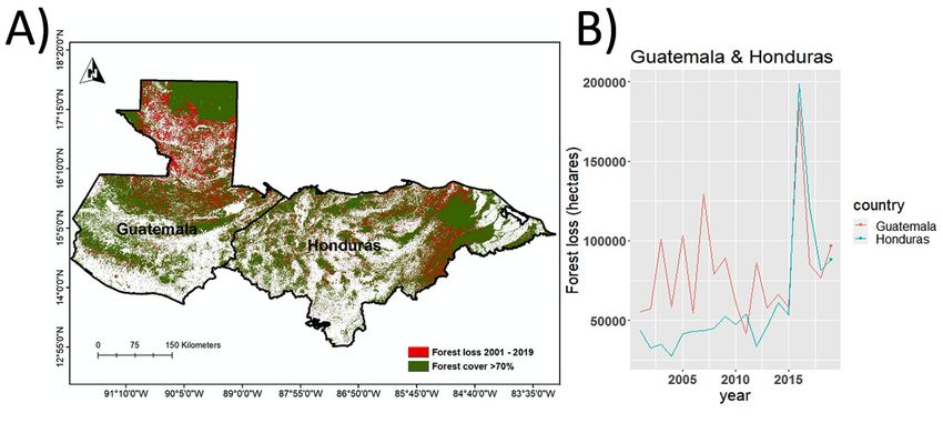
hectares loss per year are summarized in Figure 2.
To identify the bounds of de jure public lands, we used the World Protected Areas database, focusing on
protected areas with ‘strict’ protection, in national parks or regions where, in theory, forest loss and land
use change are not permitted. These include IUCN governance category I and II, strict nature reserves and
national parks, and exclude multiple use or buffer zones where PA residents and neighbors practice commu-
nity forestry. We hereafter use the term protected areas, but only refer to these regions with strict protection
in this paper (Figure 3).
Table 5: Consolidated data on forest loss, protected areas, and Indigenous territories in for Guatemala and
Honduras.
Variable Description Temporal Scale, Source
Resolution, N
Forest loss Annual forest loss at 30 m 2000–2019, 30 m Hansen et al. 2013
Protected areas Polygons of protected areas with 257 for Guatemala and World Protected
designation 95 for Honduras Areas Database
(2016)
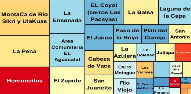
Community conces- Polygons of active and canceled commu- 9 active 25-year conces- CEMEC Guatemala,
sions/community nity concessions (Guatemala), and areas sions and 3 canceled in 2016; Honduras:
managed areas of community management (Honduras) 2009 in Petén; 50 areas Instituto de Con-
of community manage- servation Forestal
ment in Honduras from (ICF), 2019
1996–2015
Indigenous Territories Polygons of Central American Indig- 36 in Guatemala and Central America
enous Territories (titled and untitled) 25 in Honduras, plus 14 (IUCN) and Mos-
and recent Indigenous collective titles in titled territories in La quitia (Herlihy
Gracias a Dios, Honduras. Mosquitia 2019)Tellman et al: Narcotrafficking and Land Control in Guatemala and Honduras 143 Figure 2: Forest loss from 2001–2019 in Honduras and Guatemala. A) Map of forest loss and forest cover remaining. B) Forest loss in hectares per year in each country. Figure 3: Indigenous territories and protected areas in Guatemala and Honduras (IUCN 2016), with recently recognized Indigenous territory concessions in La Mosquitia (from Herlihy & Tappan 2019). For an imperfect initial measure of lands held in de facto community commons, we used the IUCN 2016 map of Indigenous peoples’ territories in Central America. In some cases, legal titles transferred state land ownership to Indigenous territories in Honduras from 2012 to 2016 (Figure 3). Finally, community con- cessions, or regions where the State has long-term leases of community managed forest, were obtained for Guatemala (from CEMEC 2016) and Honduras from The Instituto de Conservación Forestal (ICF 2019) (Supplementary Figure 1). Data Analysis Methods Our methods aimed to document the spatio-temporal dynamics of land control and the role of narcotraf- ficking, and to relate those shifts in land control to forest loss. We employed a mixed-methods analytical approach drawing from cross-site comparison techniques (Magliocca et al. 2014). Cross-site comparison
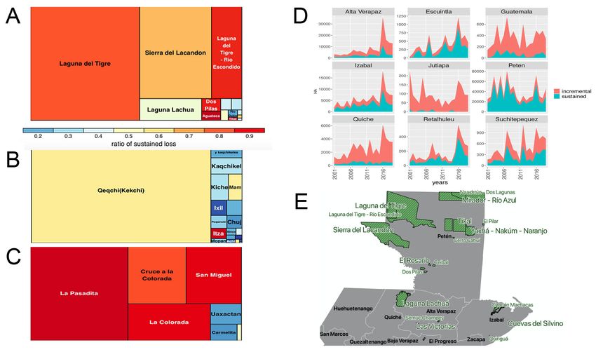
144                                       Tellman et al: Narcotrafficking and Land Control in Guatemala and Honduras

between Guatemala and Honduras is used to both quantify and understand common processes of land
control change. We examine the number and location of clandestine airstrips, public documents of known
narcotraffickers’ assets and land seizures, number and location of media events, and NGO perceptions of
narcotrafficking related land control. We then map or graph these secondary sources of land control data at
the department or municipality at annual time steps, and interpret corroboration (and disagreement) across
datasets. Interviews and surveys are used to understand how narcotrafficking versus other types of illicit
activity might influence land control. We compared survey data responses regarding the impact of illicit
activity versus narcotrafficking across 17 socio-economic impacts grouped into three categories ‘Govern-
ance’, ‘Economy’, and ‘Land’ with a nonparametric Independent Samples Mann-Whitney U Kruskal-Wallis
test (R v. 3.6.2, [R Core Team 2019]).
  We then analyze two types of forest loss patterns, which we hypothesize are outcomes of two distinct types
of land control. First, we define ‘incremental’ forest loss as slow, small, dispersed clearings, likely related to
natural disturbance or subsistence agriculture, and a typical forest pattern in the region.
  Second, we define ‘sustained’ forest loss when average clearing rates per patch increase above the thresh-
old observed to be anomalous in previous studies and require significant capital to clear in each country (see
Sesnie et al. 2017). To identify incremental versus sustain forest loss patterns, we calculated average annual
clearing rates for each contiguous forest loss patch (2000–2019) in Honduras and Guatemala. Incremental
clearing rates were defined as 3ha/yr in Honduras. We summarize the total amount and percentage of forest
loss in these two patterns for three de jure land categories, Common, Public, and Private (Table 1) for the
active deforestation frontier region in each country. Active deforestation frontiers are defined as depart-
ments with average forest loss rates of >1% loss per year or >50,000 total forest loss from 2000–2019.
  We hypothesize incremental forest loss is related to business-as-usual smallholder agriculture or resource
extraction and represent steady land change (control type I), and a shift in pattern to sustained loss indicates
large landholders have gained control (control type II, Figure 1). Not all large landholders are narcotraffick-
ers; frontiers are dynamics spaces with many actors clearing land, some with licit capital. Land dispossession
caused by narcotraffickers or other armed actors can be followed by corporate actors who rapidly clear land
(Ballvé 2018; Darién 2021; Murillo-Sandoval et al. 2021). Incomplete empirical data on land control prevent
straightforward quantification of the amount of sustained forest loss directly or indirectly attributable to
narcotrafficking. Instead we use cross site comparison techniques (Magliocca et al. 2014) to corroborate
where and when changes in narco-influenced land control shifts likely precipitate change in forest loss pat-
terns from incremental to sustained. To do so, we interpret the spatio-temporal patterns of land control and
land change in tandem.

Results
Narco-influenced Land Control in Guatemala
In Guatemala, secondary evidence indicates significant land control by narcotraffickers in Northern Gua-
temala and along the Pacific Coast. Drug trafficking data from media (Figure 4A) and counterdrug inter-
diction (Figure 4B) indicate high trafficking intensity in Northern Guatemala (Petén, Izabal, and Alta
Verapaz departments) and the Pacific Coast (Escuintla and San Marcos departments in particular). Land
control indicators of seizure accusations in protected areas (n = 1190) and clandestine airstrips (n = 217)
were concentrated in Izabal (n = 130 and 29, respectively) and the Petén (n = 954 and 120, respectively)
(Figure 4C and 4D).
  Detailed spatial data on land control by narcotraffickers available in the Petén (Figure 4) indicate a shift in
control from small holders to large, absentee landowners in legally held private lands. The data also indicate
a shift in control from publicly held land (e.g., Lacandon National Park) to privately held land. Land seizure
data from Caso Genesis indicates DTOs developed cattle ranches operated illegally inside protected areas (e.g.,
Sierra Lacandon). DTOs seized land from peasants by force (over 30,000 ha documented), also converting terri-
tories to cattle ranches. Legally owned DTO territories were cleared of forest for oil palm (Furumo & Aide 2017)
and cattle ranching in the early and mid 2000s (Figure 5A) on over 80,000 ha which were previously forest.
  Sufficient annual data were available and distinct trends evident in Guatemala in two departments, the
Petén and Izabal. In the Petén, land seizures rise in 2003 and are highest from 2005–2009 (Figure 6A), the
same period when media and CCDB data indicate high narcotrafficking activity intensity. Likewise, forest
loss increased in the Petén in ~2003–2009, decreased for several years (~2010–2015), and increased in a sec-
ond wave in about 2016–present. In contrast, in Izabal, land seizures begin to rise in 2008 and peak in 2015,
about five years following the peak activity in narcotrafficking identified in the Petén (Figure 6B). Likewise,
Izabal forest loss increased in the mid 2000s and peaked in 2016.
You can also read