TECHNICAL REPORT ON THE WOLF GOLD PROJECT, FREMONT COUNTY, WYOMING, USA - Visionary Gold Corp.
←
→
Page content transcription
If your browser does not render page correctly, please read the page content below
MINE DEVELOPMENT ASSOCIATES
A DIVISION OF RESPEC

                         TECHNICAL REPORT
                     ON THE WOLF GOLD PROJECT,
                  FREMONT COUNTY, WYOMING, USA

 Submitted to:
                                                                        Author:
VISIONARY              410-325 Howe Street                              Odin D. Christensen, PhD CPG
GOLD CORP.             Vancouver, BC V6C 1Z7 Canada                     Michael Ressel, PhD, CPG

                                                      Report Date:    December 8, 2020
775-856-5700                                          Effective Date: October 31, 2020
210 S Rock Blvd
Reno, NV 89502
www.mda.com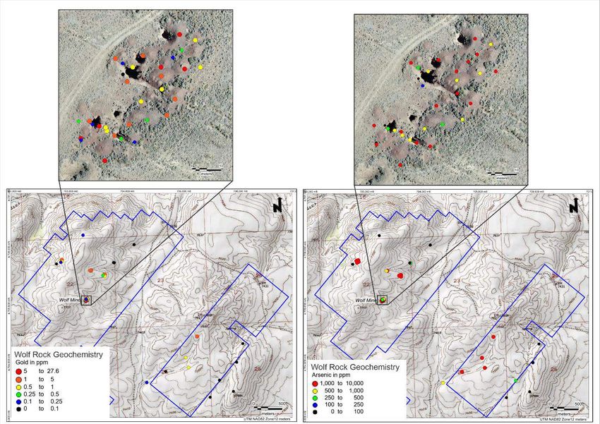
MINE DEVELOPMENT ASSOCIATES
A DIVISION OF RESPEC

T A B LE   OF     C O N T EN T S
        SUMMARY .................................................................................................................................... 1

        INTRODUCTION ........................................................................................................................... 4
             Project Scope and Terms of Reference ................................................................................ 4
             Frequently Used Acronyms, Abbreviations, Definitions, and Units of Measure ................ 5

        RELIANCE ON OTHER EXPERTS .............................................................................................. 8

        PROPERTY DESCRIPTION AND LOCATION........................................................................... 9
             Location................................................................................................................................ 9
             Wolf Project Mineral Tenures ............................................................................................ 10
             4.2.1 Lode Mining Claims .............................................................................................. 10
             4.2.2 Leased Patented US Lode Mining Claims............................................................. 16
             4.2.3 Wyoming State Lands ........................................................................................... 18
             4.2.4 Agreements and Encumbrances ............................................................................ 19
             Environmental Permits ....................................................................................................... 20
             Environmental Liabilities ................................................................................................... 20
             Surface Rights .................................................................................................................... 20
             Location Favorability ......................................................................................................... 21
             Location Cultural Sites ....................................................................................................... 22
             Wilderness Study Area ....................................................................................................... 23

        ACCESSIBILITY, CLIMATE, LOCAL RESOURCES, INFRASTRUCTURE AND
        PHYSIOGRAPHY ........................................................................................................................ 24
             Access ................................................................................................................................ 24
             Climate ............................................................................................................................... 24
             Local Resources and Infrastructure .................................................................................... 25
             Physiography ...................................................................................................................... 25

        HISTORY ...................................................................................................................................... 27
             History of the Lewiston District ......................................................................................... 27
             Previous Exploration .......................................................................................................... 29
             6.2.1 Geochemical Investigations................................................................................... 29
             6.2.2 Geophysical Investigations .................................................................................... 29

775-856-5700

210 South Rock Blvd.
Reno, Nevada 89502
www.mda.com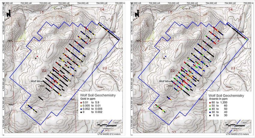
Technical Report on the Wolf Gold Project
               Fremont County, Wyoming, USA                                                                                                                      Page ii

       GEOLOGICAL SETTING AND MINERALIZATION ............................................................... 30
           Regional Geologic Setting ................................................................................................. 30
           District Geological Setting ................................................................................................. 32
           Gold Mineralization ........................................................................................................... 35

       DEPOSIT TYPES ......................................................................................................................... 39

       EXPLORATION ........................................................................................................................... 43
           Geological Mapping ........................................................................................................... 43
           Geochemical Sampling ...................................................................................................... 43
           Geophysical Investigations ................................................................................................ 45
           Remote Sensing .................................................................................................................. 46
            9.4.1 Satellite Imagery .................................................................................................... 46
            9.4.2 Drone-acquired Aerial Imagery ............................................................................. 47

       DRILLING .................................................................................................................................... 48

       SAMPLE PREPARATION, ANALYSIS AND SECURITY ....................................................... 49
           Rock-chip Geochemical Samples ...................................................................................... 49
           Soil geochemical samples .................................................................................................. 49

       DATA VERIFICATION ............................................................................................................... 50

       MINERAL PROCESSING AND METALLURGICAL TESTING ............................................. 51

       MINERAL RESOURCE ESTIMATES ........................................................................................ 52

       MINERAL RESERVE ESTIMATES ........................................................................................... 53

       MINING METHODS .................................................................................................................... 54

       RECOVERY METHODS ............................................................................................................. 55

       PROJECT INFRASTRUCTURE .................................................................................................. 56

       MARKET STUDIES AND CONTRACTS .................................................................................. 57

       ENVIRONMENTAL STUDIES, PERMITTING AND SOCIAL OR COMMUNITY IMPACT
       ....................................................................................................................................................... 58
                  Native American Interests .................................................................................................. 58

       CAPITAL AND OPERATING COSTS ....................................................................................... 59

       ECONOMIC ANALYSIS ............................................................................................................. 60

       ADJACENT PROPERTIES .......................................................................................................... 61

       OTHER RELEVANT DATA AND INFORMATION ................................................................. 62

Mine Development Associates                                                                                    S:\Wolf Project\Lewiston District Technical Report - v5.docx
December 8, 2020                                                                                                                                Updated: 12/8/20 4:01 PM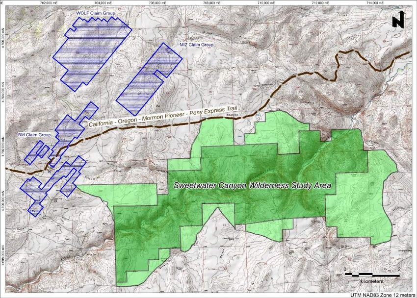
Technical Report on the Wolf Gold Project
Fremont County, Wyoming, USA Page iii
INTERPRETATION AND CONCLUSIONS .............................................................................. 63
RECOMMENDATIONS .............................................................................................................. 64
REFERENCES .............................................................................................................................. 66
AUTHORS’ CERTIFICATES ...................................................................................................... 69
T A B LE S
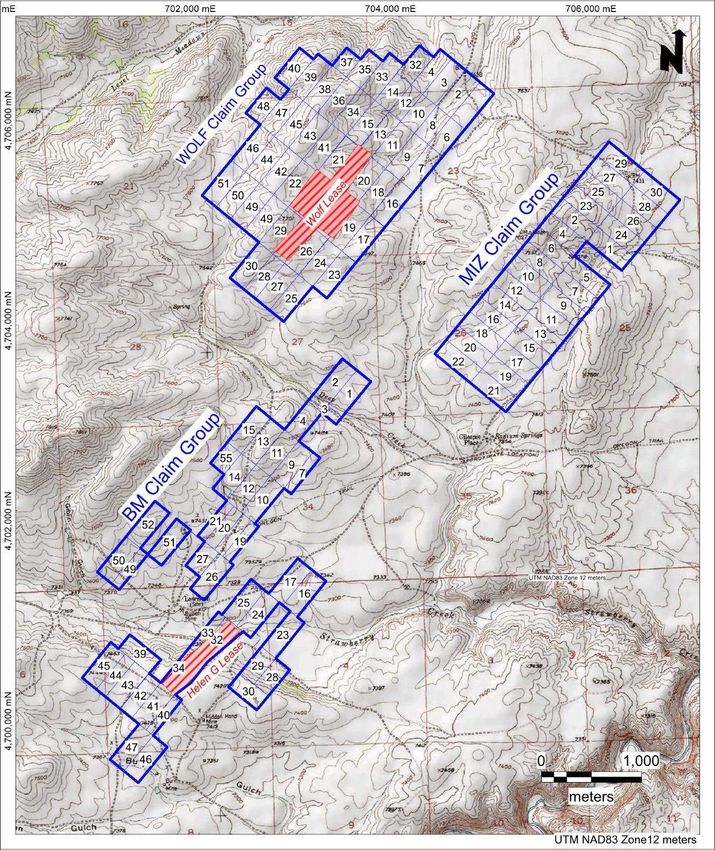
Table 4.1 Type and Areas of Mineral Tenure at the Wolf Property, Wyoming..................................... 10
Table 4.2 List of US Unpatented Lode Mining Claims ......................................................................... 12
Table 5.1 Climate Data for Atlantic City, Wyoming: 2000-2020. ......................................................... 24
Table 8.1 Table Summarizing Critical Characteristics of Orogenic Gold Deposits .............................. 42
Table 26.1 Proposed Phased Exploration Program Budget ..................................................................... 65
F IG U RE S
Figure 4.1 Wolf Project Area Location Map .............................................................................................. 9
Figure 4.2 Map Showing Location of the Wolf Property Lode Mining Claims ...................................... 11
Figure 4.3 Map Showing the Location of the Wolf Property Lode Mining Claims and Wyoming State
Leases ..................................................................................................................................... 19
Figure 4.4 Location of Historic Trails and Sweetwater Canyon Wilderness Study Area ........................ 22
Figure 5.1 Typical Topography, Vegetation, and Rock Outcroppings of the Project Area ..................... 26
Figure 6.1 Location of the South Pass-Atlantic City and Lewiston Mining Districts .............................. 27
Figure 7.1 Location of the South Pass Granite Greenstone Belt in the Wyoming Craton ....................... 30
Figure 7.2 Cross-Section Across the Southern Margin of the Wind River Range ................................... 31
Figure 7.3 Geologic Map of the Wolf Project Area ................................................................................. 32
Figure 7.4 Schematic Geologic Map and Northwest-Southeast Cross Section Across the South Pass
Greenstone Belt ...................................................................................................................... 35
Figure 7.5 Selected Prominent Historical Mines in the Lewiston Mining District .................................. 37
Figure 8.1 Schematic Illustration of Gold-Rich Epigenetic Mineral Deposits ........................................ 39
Figure 8.2 Schematic Representation of Crustal Environment of Orogenic Gold Deposits .................... 40
Figure 9.1 Gold and Arsenic in Rock-Chip Geochemical Samples from the Wolf Mine ........................ 44
Figure 9.2 Gold and Arsenic in Soil Geochemical Samples from the Wolf Mine Area .......................... 44
Figure 9.3 Location of 2020 IP Geophysical Lines at the Wolf Mine ..................................................... 45
Figure 9.4 IP Section 1000 SE, Looking Northeast ................................................................................. 46
Mine Development Associates S:\Wolf Project\Lewiston District Technical Report - v5.docx
December 8, 2020 Updated: 12/8/20 4:01 PM
MINE DEVELOPMENT ASSOCIATES
A DIVISION OF RESPEC

        SUMMARY

The Wolf Gold Project is located in the historical Lewiston mining district in southwestern Wyoming, at
the southeastern end of the Wind River Range in Fremont County. Visionary Gold Corp (“Visionary”)
began acquisition of mineral interests and to stake unpatented US lode mining claims in the Lewiston
district in early 2020. Mine Development Associates (“MDA”) has prepared this technical report on the
Wolf gold exploration project at the request of Visionary. This report has been prepared in accordance
with the disclosure and reporting requirements set forth in the Canadian Securities Administrators
National Instrument 43-101 (“NI 43-101”), Companion Policy 43-101CP, and Form 43-101F1, as
amended.

The Wolf property is a direct 17km east-southeast of Atlantic City, Wyoming, and a direct 45km south-
southeast of the City of Lander, Wyoming. Access is by paved highway for about 50km, then by well-
maintained public gravel roads for about 20km. The property covers a total area of 2165 hectares.

Topography of the project area is a gently rolling landscape at an elevation of about 2250 meters with
high semi-arid climate and semidesert vegetation. Winters are very cold and summers pleasantly warm,
with averages of 45cm rain and 335cm of snow.

Visionary has three types of mineral rights in the Wolf project area. The company staked 121 unpatented
US lode mining claims in three separate groups covering an area of 915.3ha. The company has possessory
mineral interest in the located lode claims under the General Mining Law of 1872, as amended. Visionary
has leased rights to two groups of patented lode mining claims, the Ruby group of four claims containing
41.7ha, and the Helen G group of two claims covering containing 17.5ha. Both leases are for three years,
with provision to remain in effect so long as royalties are paid. The leases confer a 2% NSR royalty to
the owners of the claims and an additional 2% royalty to a previous leaseholder who assigned the leases
to Visionary. Visionary has leased mineral rights to Wyoming State land in 14 parcels covering 1190ha.
Royalties for metallic mineral production from state lands, based on sales value per short ton production,
range from 5% to 10%.

Wyoming is considered a favorable jurisdiction for mineral development. The state was ranked 6th of the
United States for favorability and 29th of 76 jurisdictions internationally in the 2019 Fraser Institute
Annual Survey of Mining Companies. The nearby Sweetwater Canyon Wilderness Study Area does not
impact this exploration area. The property is transected by the historic Oregon, California, Mormon-
Pioneer, and Pony Express Trails. Surface activities must be planned and conducted to avoid disruption
of these tracks.

775-856-5700

210 South Rock Blvd.
Reno, Nevada 89502
www.mda.com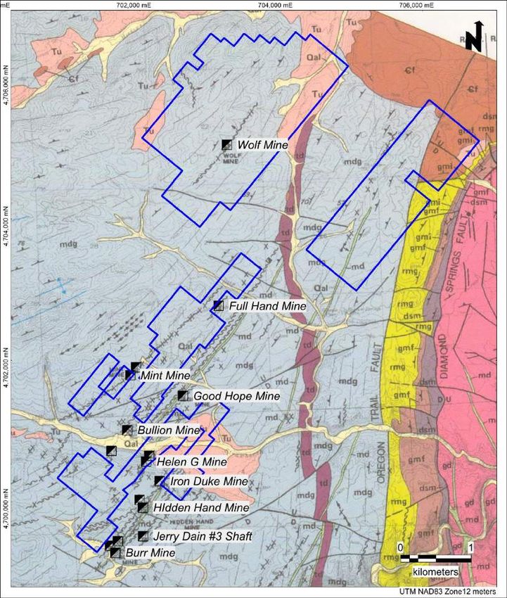
Technical Report on the Wolf Gold Project
             Fremont County, Wyoming, USA                                                                                     Page 2

Gold was discovered in the Lewiston and adjacent South Pass-Atlantic City mining districts in 1842,
launching a period with many small mines through the remainder of the century. Another period of gold
mining activity occurred between 1933 and 1941. Only minor amounts of gold have been mined since
the Second World War. During the period 1962 through 1983, United States Steel mined banded iron
formation, with the taconite iron ore shipped to the smelter in Geneva, Utah. This large-scale mining
activity demonstrates the favorability of the location for mine development and production. Gold
exploration campaigns have been conducted in the district by numerous companies over the past decades,
with no results yet warranting mine development.

The Lewiston mining district occurs in an area of Archean rocks of the Wyoming craton – part of the
ancient geologic core of North America. All known gold mineralization within the Atlantic City-South
Pass and Lewiston districts is hosted within supracrustal rocks of the South Pass granite-greenstone
terrane. Units lower in the stratigraphy include serpentinite, tremolite-talc-chlorite schist, pelitic schist,
quartzite, amphibolite, and banded iron formation. These units are overlain by the Archean Miners Delight
Formation, a unit dominantly of metagraywacke, interpreted to have been deposited in a deep ocean basin
with sedimentary and volcanic contributions. All rocks of the South Pass granite-greenstone belt have
been subjected to a sequence of deformational events that folded the rocks into a synclinorium. The
Atlantic City-South Pass district is located along the northern limb of this fold; the Lewiston district is
located along the southern limb. Gold mineralization was synchronous with deformation and
metamorphism. Several periods of magmatism emplaced generally felsic plutons and mafic dikes.

Known gold mineralization in the South Pass granite-greenstone belt is dominantly localized along strike-
parallel ductile shear zones, particularly where these shears penetrate competent lithologies. Most
auriferous structures contain only minor silver. The lode gold deposits known in the Lewiston district are
orogenic gold deposits that formed during orogenic or mountain-building events, presumably in Archean
time. Orogenic gold deposits are typified by quartz-dominant vein systems with relatively low abundances
of sulfide minerals. Gold to silver ratios of ores range from 10 to 1. Gold grades in orogenic gold deposits
are commonly high, in the 5-30g Au/t range. There is a strong structural control of mineralization at all
scales. Deposits are normally localized in second- or third-order structures proximal to large-scale trans-
crustal structures. Ore commonly occurs in steeply inclined shoots with down-dip continuity of hundreds
to a thousand meters or more.

Visionary initiated exploration activities in 2020. The company completed an initial program of geologic
mapping centered on the historical Wolf Mine. This work helped define the dimensions, gold distribution
and orientation of the mineral-controlling structure needed to design an effective drill-test. Rock-chip
geochemical sampling, concentrated near the Wolf Mine, was designed to characterize the character and
extent of alteration and mineralization at that occurrence. Systematic soil geochemical sampling extended
across the Wolf group of claims. Three lines of an induced polarization electrical geophysical survey
were completed within the same area.

To the best of our knowledge and available public and historical documents, the Lewiston district has
never been tested by drilling. In effect, there has been no exploration below a depth of about 50 meters.

The Wolf property is a property of merit that warrants additional exploration. The existence of widespread
alteration specifically in the area of the Wolf Mine and in the Miners Delight Formation at a district scale,

Mine Development Associates                                                 S:\Wolf Project\Lewiston District Technical Report - v5.docx
December 8, 2020                                                                                             Updated: 12/8/20 4:01 PM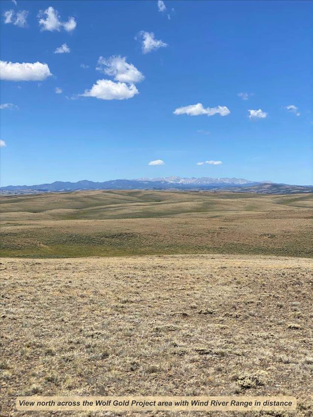
Technical Report on the Wolf Gold Project
             Fremont County, Wyoming, USA                                                                                    Page 3

and mineralization with elevated precious metals grades in the historical record indicate potential for the
Wolf Project to host gold deposits of economic interest.

A phased exploration program is recommended to prudently explore the property. Key objectives of Phase
1 exploration will be to determine the geological ‘signature’ of known mineralized structures and controls
and to use these characteristics as vectors for the definition of other potentially mineralized areas. Work
will be focused on the Wolf (Ruby) lease area and may include:
    • Compilation of available historical technical and non-technical information.
    • Multielement soil geochemistry.
    • Geophysical surveys, including consideration of very low frequency electromagnetics (VLF-
        EM), ground magnetics, and induced polarization (IP) to define target zones within identified
        structural corridors.
    • Development of an “exploration toolbox” and geological model for testing.

Phase 2 will refine targets and drill-test the Wolf Mine structural corridor and identify targets within the
Lewiston district, through:
   • Continued acquisition of geological, geochemical, and geophysical information along the Wolf
       Mine shear zone.
   • Property-scale geological mapping to characterize the geological and structural framework of the
       property.
   • Planning, permitting, and drilling of two or three fences of holes crossing the Wolf Mine
       structure, to define the geology to a depth of at least 100 meters.
   • Expansion of multielement soil geochemistry data to cover principal targets areas within all three
       claim blocks.
   • Expansion of geophysical surveys to cover target areas within all three claim blocks.

   The estimated cost of Phase 1 exploration is US$196,650. The estimated cost of Phase 2 exploration
   is US$894,700.

Mine Development Associates                                                S:\Wolf Project\Lewiston District Technical Report - v5.docx
December 8, 2020                                                                                            Updated: 12/8/20 4:01 PM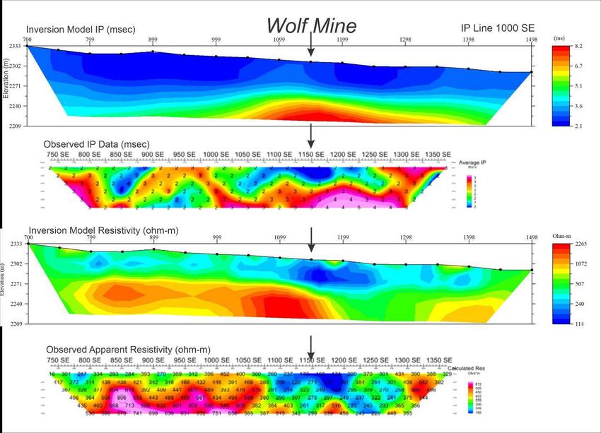
Technical Report on the Wolf Gold Project
             Fremont County, Wyoming, USA                                                                                   Page 4

       INTRODUCTION

The Lewiston district is an historical mining district located at the southern end of the Wind River Range
in Fremont County, Wyoming. Beginning in early 2020, Galileo Exploration Ltd. (TSXV:GXL) began
to acquire mineral interests, including staking unpatented US lode mining claims in the district. On
November 25, 2020, Galileo announced a name change to Visionary Gold Corp. (Visionary) and launch
of a new website (www.visionarygoldcorp.com) as part of a corporate reorganization and re-branding.
Visionary has adopted "VIZ" as the new trading symbol for its common shares.

Mine Development Associates (“MDA”) has prepared this technical report on the Wolf gold exploration
project in the Lewiston mining district of Fremont County, Wyoming, at the request of Visionary. This
report has been prepared in accordance with the disclosure and reporting requirements set forth in the
Canadian Securities Administrators National Instrument 43-101 (“NI 43-101”), Companion Policy 43-
101CP, and Form 43-101F1, as amended.

       Project Scope and Terms of Reference

The purpose of this report is to provide a technical summary of the Wolf Gold Project in support of
securities regulatory reporting requirements. The Wolf gold project is located in the historical Lewiston
mining district at the southern limit of the Wind River Range in Fremont County, Wyoming. The district
was discovered in the 1860’s and saw intermittent limited production from several small mines in the late
1800’s and early 1900’s. Numerous companies have explored portions of the district in subsequent years.
There have been no prior NI 43-101 technical reports prepared for the subject property. There are no
current mineral resource estimates for the project area.

Odin D. Christensen is an independent consulting geologist retained by MDA for the preparation of this
report. Dr. Christensen has more than four decades of experience as a professional geologist and is a
qualified person under NI 43-101. The author is independent of and has no prior affiliation with Visionary.
Michael W. Ressel works as a senior geologist for MDA in Reno, Nevada. Dr. Ressel has more than 30
years of experience as a geologist, is a qualified person under NI 43-101, and is independent of and has
no prior affiliation with Visionary.

The scope of this study included a review of pertinent technical reports and data provided to MDA by
Visionary relative to the general setting, geology, project history, exploration activities and results,
methodology, quality assurance, and interpretations. The authors have, as well, reviewed technical reports
available in the public domain relative to geology and history of the project area. The authors have relied
upon this material for the preparation of this report.

Dr. Christensen visited the Wolf project on October 1, 2020, accompanied by Mr. Wesley Adams, Chief
Executive Officer and Director of Visionary. During the visit, Christensen toured the surface and
reviewed the general geology of the district, including visits to numerous historical prospect pits and
mines. Christensen collected a suite of samples for check geochemical analysis.

The authors have relied upon data and information available in the public domain and provided by
Visionary. The authors have reviewed much of the available data and Dr. Christensen made a site visit.
The authors have made judgements about the general reliability of the underlying data and have made

Mine Development Associates                                               S:\Wolf Project\Lewiston District Technical Report - v5.docx
December 8, 2020                                                                                           Updated: 12/8/20 4:01 PM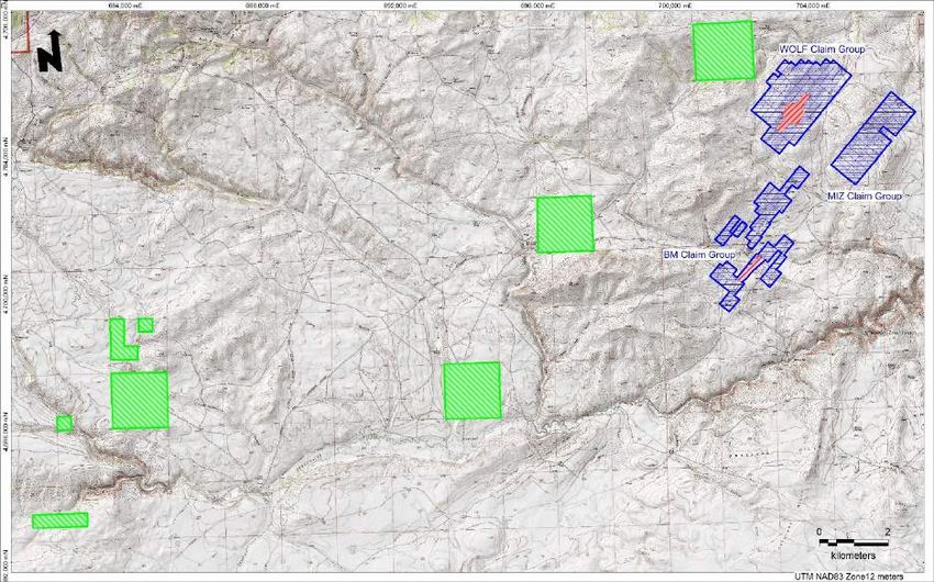
Technical Report on the Wolf Gold Project
              Fremont County, Wyoming, USA                                                                                           Page 5

such independent investigations as deemed necessary in the professional judgement of the authors to be
able to reasonably present the conclusions discussed herein.

The effective date of the technical report is October 31, 2020.

         Frequently Used Acronyms, Abbreviations, Definitions, and Units of Measure

In this report, measurements are generally reported in metric units. Where information was originally
reported in Imperial units, MDA has made the conversions as shown below.
Currency, units of measure, and conversion factors used in this report include:

Linear Measure
         1 centimeter                      = 0.3937 inches
         1 meter                           = 3.2808 feet
         1 kilometer                       = 0.6214 miles

Area Measure
      1 hectare                            = 2.471 acres                      = 0.0039 square miles
      1 square kilometer                   = 0.386 square miles

Weight
         1 troy ounce                      = 31.103 grams
         1 kilogram                        = 2.205 pounds
         1 tonne                           = 1.1023 short tons                = 2,2205 pounds

Concentration
      1 percent (%)                        = 10,000 parts per million (ppm)
      1 part per million (ppm)             = 10,000 parts per billion (ppb)
      1 troy ounce/ton                     = 34.286 grams/ton

Currency. Unless otherwise indicated, all references to dollars ($) in this report refer to currency of the
United States of America.

Deposit. Unless modified by some other adjective, “deposit” means “mineral deposit”; a mass of naturally
occurring mineral material, usually in a concentration greater than local background concentrations, some
of whose constituents may have economic value under certain circumstances. Some, but not all, mineral
deposits may merit exploration for their economic potential. The use of the term does not imply that the
deposit contains a “Mineral Resource”, as defined by the Canadian Institute of Mining, Metallurgy and
Petroleum (2014).

Geographic Coordinates. Unless otherwise indicated, all geographic coordinates used in this report are
Universal Transverse Mercator, North American 1983 Datum, Zone 12T, meters (UTM NAD83 Z12).
See also “Public Land Survey System”, below.

“Historical Estimate”. As defined by NI 43-101 “means an estimate of the quantity, grade, or metal or
mineral content of a deposit that an issuer has not verified as a current mineral resource or mineral reserve,

Mine Development Associates                                                        S:\Wolf Project\Lewiston District Technical Report - v5.docx
December 8, 2020                                                                                                    Updated: 12/8/20 4:01 PM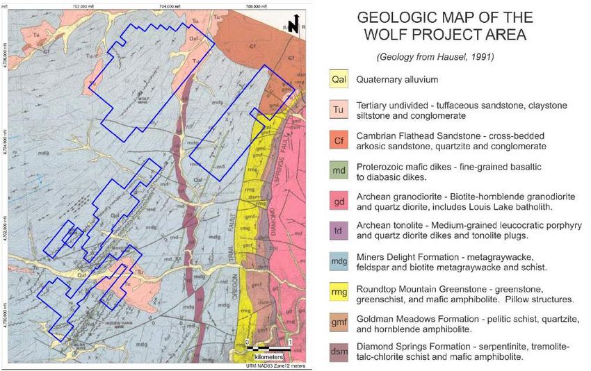
Technical Report on the Wolf Gold Project
             Fremont County, Wyoming, USA                                                                                   Page 6

and which was prepared before the issuer acquiring, or entering into an agreement to acquire, an interest
in the property that contains the deposit.”

Public Land Survey System (“PLSS”) is the surveying method developed and used in the United States
to plat, or divide, real property for sale and settling. The following terminology from the PLSS is used in
some parts of this report:
         Range (R): A measure of the distance east or west from a referenced principal meridian, in units
         of six miles.
         Section: An approximately one-square-mile block of land. There are 36 sections in a survey
         township.
         Township (T): (1) Synonym for survey township, i.e., a square parcel of land of 36 square miles,
         or (2) A measure of the distance north or south from a referenced baseline, in units of six miles.
PLSS surveys in this portion of Wyoming are based in the 6th Principal Base and Meridian.

Frequently used acronyms and abbreviations

AA                   atomic absorption spectrometry – an analytical method
Ag                   silver
As                   arsenic
Au                   gold
BLM                  United States Bureau of Land Management
CFR                  Code of Federal Regulations (United States)
CIM                  Canadian Institute of Mining, Metallurgy and Petroleum
cm                   centimeters
°C                   degrees centigrade
DEQ                  Wyoming Department of Environmental Quality
°F                   degrees Fahrenheit
FA                   fire assay – an analytical method for precious metals
ft                   foot or feet
FWS                  United States Fish and Wildlife Service
g                    gram
GA                   billion years
GPS                  Global Positioning System – satellite system used for ground location. Also
                     colloquially refers to the receivers used to obtain such locations from the system.
g/t                  grams per tonne. Expression of an element’s concentration, e.g. “g Au/t”.
ha                   hectares
ICP-AES              inductively coupled plasma atomic emission mass spectrometry – an analytical
                     method.
ICP-MS               inductively coupled plasma mass spectrometry – an analytical method.
ICP_OES              inductively couples plasma mass spectrometry – optical emission spectroscopy – an
                     analytical method.
ICP                  inductively coupled plasma spectrometry; a more general term including the above
                     three methods
kg                   kilograms
km                   kilometers
LLC or L.L.C.        Limited Liability Company

Mine Development Associates                                               S:\Wolf Project\Lewiston District Technical Report - v5.docx
December 8, 2020                                                                                           Updated: 12/8/20 4:01 PM
Technical Report on the Wolf Gold Project
Fremont County, Wyoming, USA Page 7
m meters
Ma million years old
mm millimeters
mt metric tonnes
NCDC National Climatic Data Center
NEPA National Environmental Policy Act
NI 43-101 National Instrument 43-101, a national instrument for the Standards of Disclosure for
Mineral Projects which come under the jurisdiction of the Canadian Securities
Administrators (“CSA”). As a codified and standardized reporting format, it is
sometimes voluntarily used even in situations where the CSA have no jurisdiction.
Also written as “NI 43-101”.
NSR net smelter return
oz ounce – in this report meaning troy ounce
ppm parts per million
ppb parts per billion
SFA Sagebrush Focal Area – an area proposed as having outstanding sage grouse habitat
t metric ton or tonne
ton Imperial short ton
T, R township and range, as in for example “T44N, R53E” or “T44 North, R53 East”
Mine Development Associates S:\Wolf Project\Lewiston District Technical Report - v5.docx
December 8, 2020 Updated: 12/8/20 4:01 PMTechnical Report on the Wolf Gold Project
Fremont County, Wyoming, USA Page 8
RELIANCE ON OTHER EXPERTS
The authors are not experts in legal matters, such as the assessment of the legal validity of mining claims,
private land, mineral rights, and property agreements in the United States. The authors did not conduct
in-depth investigations of the environmental, permitting, or social-economic issues associated with the
Wolf Gold Project, and the authors are not experts with respect to these issues.
The authors have relied upon Wesley Adams, Chief Executive Officer of Visionary, and Darren Lindsay,
Director of Visionary, for information concerning the status of Visionary claims and property agreements
associated with the Wolf project, and for information concerning the environmental, permitting and social-
economic issues associated with the project.
Sections 4.0 and 13.0 are based on information provided by Visionary. The authors have verified, as
possible, the consistency of the information provided in this section with public records, but they offer no
professional opinion regarding the provided information.
The authors particularly acknowledge the value of numerous conversations and communication with
Darren Lindsay, Director of Visionary.
Mine Development Associates S:\Wolf Project\Lewiston District Technical Report - v5.docx
December 8, 2020 Updated: 12/8/20 4:01 PMTechnical Report on the Wolf Gold Project
Fremont County, Wyoming, USA Page 9
PROPERTY DESCRIPTION AND LOCATION
Location
The Wolf Gold Project is located in southwestern Wyoming at the southern end of the Wind River Range
in Fremont County, Wyoming. The property covers a total area of 2165 hectares (5350 acres) in all or
parts of Sections 14, 15, 21, 22, 23, 24, 25, 26, 27, 33, and 34, Township 29 North, Range 98 West, 6th
Principal Meridian; and Sections 4, 5, 6 and 8, Township 28 North, Range 98 West, 6th Principal Meridian.
The Wolf project is located a direct 17 kilometers east-southeast of the small community of Atlantic City,
Wyoming, and a direct 45 kilometers south-southeast of the City of Lander Wyoming, the county seat of
Fremont County (Figure 4.1 and Figure 4.3). The center of the property is at approximately 42.45 degrees
North Latitude and 108.53 degrees West Longitude. The property is on the Radium Springs and Lewiston
Lakes 7 ½ minute topographic quadrangle maps of the United States Geological Survey.
Figure 4.1 Wolf Project Area Location Map
Mine Development Associates S:\Wolf Project\Lewiston District Technical Report - v5.docx
December 8, 2020 Updated: 12/8/20 4:01 PMTechnical Report on the Wolf Gold Project
Fremont County, Wyoming, USA Page 10
Wolf Project Mineral Tenures
Visionary has three types of mineral rights tenure in the Wolf project area: through US unpatented lode
mining claims, through leased US patented lode mining claims, and through leases on Wyoming state
lands.
Table 4.1 Type and Areas of Mineral Tenure at the Wolf Property, Wyoming
Mineral Tenure Number Area, hectares
Unpatented lode claims 121 915.3
Patented lode claims 2 59.2
Wyoming state lands 14 1190
4.2.1 Lode Mining Claims
Visionary, through Lost Creek Corporation (“Lost Creek”), a Wyoming corporation and wholly owned
subsidiary, has staked 121 United States lode mining claims in the project area. The claims occur within
three named claim groups, with a total area of 915.3 hectares. The named claim groups comprise five
non-contiguous claim blocks that are separated by no more than about one kilometer from an adjacent
block. The location of these claims is shown in Figure 4.2 and Figure 4.3. The company has a possessory
mineral interest in the located lode claims under the General Mining law of 1872 as amended. Surface
access as needed for mineral exploration is administered by the BLM.
Mine Development Associates S:\Wolf Project\Lewiston District Technical Report - v5.docx
December 8, 2020 Updated: 12/8/20 4:01 PMTechnical Report on the Wolf Gold Project
Fremont County, Wyoming, USA Page 11
Figure 4.2 Map Showing Location of the Wolf Property Lode Mining Claims
Unpatented lode claims in blue and leased patented lode mining claims in red.
Mine Development Associates S:\Wolf Project\Lewiston District Technical Report - v5.docx
December 8, 2020 Updated: 12/8/20 4:01 PMTechnical Report on the Wolf Gold Project
Fremont County, Wyoming, USA Page 12
Table 4.2 List of US Unpatented Lode Mining Claims
Mine Development Associates S:\Wolf Project\Lewiston District Technical Report - v5.docx
December 8, 2020 Updated: 12/8/20 4:01 PMTechnical Report on the Wolf Gold Project
Fremont County, Wyoming, USA Page 13
Mine Development Associates S:\Wolf Project\Lewiston District Technical Report - v5.docx
December 8, 2020 Updated: 12/8/20 4:01 PMTechnical Report on the Wolf Gold Project
Fremont County, Wyoming, USA Page 14
Mine Development Associates S:\Wolf Project\Lewiston District Technical Report - v5.docx
December 8, 2020 Updated: 12/8/20 4:01 PMTechnical Report on the Wolf Gold Project
Fremont County, Wyoming, USA Page 15
Mine Development Associates S:\Wolf Project\Lewiston District Technical Report - v5.docx
December 8, 2020 Updated: 12/8/20 4:01 PMTechnical Report on the Wolf Gold Project
Fremont County, Wyoming, USA Page 16
Lode Mining Claims Obligations and Recordation Information
Initial Federal Mining Claim Location and Recordation
The BLM, pursuant to Title 43 of the United States Code of Federal Regulations (43 CFR), Part 3834,
requires recording at the BLM Certificates of Location and Location Maps within 90 days of location of
a claim. Recordation of the Certificates of Location and Location maps at the BLM and Fremont County
was timely.
The unpatented lode claims in the Wolf Project area have not been surveyed by a registered surveyor, nor
is there any requirement for a registered survey to hold the claims. The unpatented Wolf, MIZ and BM
lode claims were located using sub-meter accuracy GPS equipment by a professional claim staker.
Recurring Annual Federal Mining Claims, BLM Filing Requirements – Annual Maintenance Fee
The BLM, pursuant to 43 CFR Part 3834, requires filing an annual Notice of Intent to Hold Mining Claims
on or before noon September 1 of each year in to maintain active claims. The payment is prospective and
covers the period of September 1 of the current year through August 31 the following year. The filing
dates and requirements at the BLM are subject to change.
• The BLM Annual Filings and BLM Serial Register Pages were acquired and reviewed on or before
October 31, 2020.
• The BLM annual maintenance fees for the 121 lode claims have been paid. The payment and
timely recordation is required for BLM to designate “Active Status” for the claims from September
1, 2020 through September 1, 2021.
• All of the claims listed in Table 4.1 are in “active” status according to the BLM website LR2000.
Annual Federal and State Obligations
The BLM administers unpatented claims on Federal lands under the General Mining Law of 1872 as
amended. Annual BLM maintenance fees for claims, payable by noon on September 1 of each year, are
$165 for each claim. For the Wolf project, annual Federal claim fees are 121 x $165 = $19,965. Annual
Fremont County, Wyoming, Affidavit of Notice of Intent to Hold fees for claims, payable by December
30, are $15 per unpatented lode claim for a total of $1815. Annual fees are subject to change.
4.2.2 Leased Patented US Lode Mining Claims
Visionary has leased rights to two groups of patented lode mining claims.
Ruby Lease
The Ruby claims are described in the lease agreement as:
Mine Development Associates S:\Wolf Project\Lewiston District Technical Report - v5.docx
December 8, 2020 Updated: 12/8/20 4:01 PMTechnical Report on the Wolf Gold Project
Fremont County, Wyoming, USA Page 17
Ruby, Ruby #1, Ruby #2, Ruby #4, Lode-mining claims designated by the Surveyor General as Survey
#505, embracing a portion of Sections 22 and 27, Township 29 North, Range 98 West, of the 6th Principal
Meridian, in the Lewiston Mining District, US Patent Lander 08160, consisting of 103.009 acres.
There is a lease agreement, dated June 12, 2020, by and between Janet E. Schrankler, individually and
acting as authorized trustee of the Schrankler Family Revocable Trust, a Trust under the laws of
Minnesota, and Gyorvary-Lee Mining (“GLM”), a Wyoming company for the Ruby group of claims
(“Ruby Claims Lease”). The lease permits lessee the right to explore and, if warranted, to mine valuable
minerals found on those claims. The initial term of the lease is three years, and the lease shall remain for
so long as royalties are paid the lessor. The lease specifies a net smelter returns production royalty of two
and one-half percent (2½ %). Advance Royalty Payments specified are:
$2500 upon execution of the agreement;
$2500 on or before the first anniversary;
$2500 on or before the second anniversary;
$2500 on or before each subsequent anniversary for so long as the agreement is in effect.
There is a Lease Assignment Agreement, dated September 4, 2020, by and between GLM and Lost Creek,
by which GLM agreed to assign to Lost Creek, and Lost Creek agreed to assume from GLM, all of GLM’s
rights, title, interests, obligations and liabilities of the Ruby Claims Lease and the Helen G Claims Lease.
The lease assignment specifies:
Payments on execution of $20,000 for the Ruby Claim Lease and $10,000 for the Helen G Claims
Lease;
Payment on the first anniversary of $30,000 for the Ruby Claim Lease and $10,000 for the Helen
G Claim Lease;
Annual payments shall be credited against future Royalty payment obligations and toward the
Royalty buy-out.
There is a Net Smelter Returns Royalty Agreement, dated September 4, 2020, by and between Lost Creek
and GLM, by which Lost Creek grants to GLM a royalty equal to two percent (2%) of Net Smelter Returns
from the production and sale of mineral from the properties. Within 5 years from the effective date of the
agreement, Lost Creek has the option, but not the obligation, to purchase the royalty for two-million
dollars ($2,000,000). There is provision to renew the royalty buy-out for one five-year extension.
Payments due on execution of all Ruby Lease agreements have been paid.
Helen G Lease
The claims are described in the lease agreement as:
Mill, Helen G. (aka Allen G.) and Star Lode-mining claims, designated by the Surveyor General as Lots
68, embracing a portion of Section 5, Township 28 North, Range 98 West, 6th PM. Overland Mining
District; Mineral Certificate #26, containing 43.30 acres, together with all improvements, machinery,
tools and equipment situate in the County of Fremont; State of Wyoming.
There is a lease agreement, dated July 6, 2020, by and between Janet E. Schrankler, individually and acting
as authorized trustee of the Schrankler Family Revocable Trust, a Trust under the laws of Minnesota, and
GLM for the Helen G group of claims (“Helen G Claims Lease”). The lease permits lessor the right to
Mine Development Associates S:\Wolf Project\Lewiston District Technical Report - v5.docx
December 8, 2020 Updated: 12/8/20 4:01 PMTechnical Report on the Wolf Gold Project
Fremont County, Wyoming, USA Page 18
explore and, if warranted, to mine valuable minerals found on those claims. The initial term of the lease
is three years, and the lease shall remain for so long as royalties are paid the lessor. The lease specifies a
Net Smelter Returns Production Royalty of two and one-half percent (2½ %). Advance Royalty Payments
specified are:
$2500 upon execution of the agreement;
$2500 on or before the first anniversary;
$2500 on or before the second anniversary;
$2500 on or before each subsequent anniversary for so long as the agreement is in effect.
There is a Lease Assignment Agreement, dated September 4, 2020, by and between GLM and Lost Creek,
for the Ruby Claims Lease and Helen G Claims Lease, as described above.
There is a Net Smelter Returns Royalty Agreement, dated September 4, 2020, by and between Lost Creek
and GLM, for the Ruby Claims Lease and Helen G Claims Lease, as described above.
Payments due on execution of all Helen G Lease agreements have been paid.
4.2.3 Wyoming State Lands
Visionary has leased mineral rights to Wyoming state land in 14 parcels for a total of 1190 hectares (2940
acres). Annual lease for Wyoming state sections are $1.00 per acre for lease years 1 through 5, $2.00 for
lease years 6-10. Extending the leases for a third ten-year period imposes a $3.00 per acre charge and a
fourth ten-year period a $4.00 per acre per year charge.
Mine Development Associates S:\Wolf Project\Lewiston District Technical Report - v5.docx
December 8, 2020 Updated: 12/8/20 4:01 PMTechnical Report on the Wolf Gold Project
Fremont County, Wyoming, USA Page 19
Figure 4.3 Map Showing the Location of the Wolf Property Lode Mining Claims and Wyoming
State Leases
Unpatented lode mining claims in blue, leased Wyoming state lands in green, and leased patented
lode claims in red.
4.2.4 Agreements and Encumbrances
Federal Royalty
There is no federal royalty, under the General Mining Law of 1872 as amended. The holder of mining
claims on federal lands has the right to explore, develop and mine minerals on their claims without
payment of royalties to the federal government.
Royalty for State Lands
There is a royalty obligation to the State of Wyoming for production from the leased state-owned lands.
Following is text from Wyoming Administrative Rules - Office of Lands and Investment Wyoming
(2020).
“Section 7. Royalties.
(a) Royalties for metallic & non-metallic rocks & minerals shall be based on the terms of the particular
lease agreement, subject to all state royalty statutes and rules, and shall be based on the total consideration
received for state production. The following royalty rates shall apply, unless a different rate is specifically
authorized by the Board:
Mine Development Associates S:\Wolf Project\Lewiston District Technical Report - v5.docx
December 8, 2020 Updated: 12/8/20 4:01 PMTechnical Report on the Wolf Gold Project
Fremont County, Wyoming, USA Page 20
Sales Value Royalty per Ton as a Percentage
$ 00.01 to $ 50.00 5%
$ 50.01 to $100.00 7%
$100.01 to$150.00 9%
$150.01 and up 10%
but in no case will royalty be less than fifty cents ($0.50)/ton
(b) After a metallic & non-metallic rocks & minerals lease becomes an operating lease, the Board may
reduce the royalty payable to the state, as to all or any of the lands or formations covered by the lease, if
it determines that such a reduction is necessary to allow the lessee to undertake additional operations or
to continue to operate with a reasonable expectation that the operations will be profitable.
Such a reduction in the royalty payable to the state shall in all cases be conditioned upon the cancellation
of all cost-free interests. The Board may also impose other conditions to the reduction in royalty.”
Environmental Permits
Any surface disturbance associated with mineral exploration activities in Wyoming on both public and
private lands requires approval from the Land Quality Division of the Wyoming State Department of
Environmental Quality (“DEQ”). The Land Quality Division is charged to ensure that any land
disturbances resulting from exploration and mining are minimal and that affected areas are restored
properly once mining is complete. This authority is derived from the Federal Surface Mining Control and
Reclamation Act, as well as the Wyoming Environmental Quality Act
Through FMG Engineering of Rapid City, South Dakota, a License to Explore by Dozing application was
made through the Lands Quality Division of the Wyoming State Department of Environmental Quality on
September 17, 2020 for an initial work program of trenching and drilling by Lost Creek. The DEQ
representative visited the site prior to the application. Additional information has been requested in
support of the original application, which has been submitted to DEQ for review. Additionally, as part of
the permitting application process, Visionary has reached out to the Wyoming Game and Fish Department
Habitat Protection Services for a sage grouse habitat protection determination.
Environmental Liabilities
Visionary is not aware of any existing environmental liabilities on the property.
Surface Rights
Access to all properties is by existing roadways across public land.
Visionary has surface access rights to the Wolf Mine and Helen G Mine private land parcels.
Visionary has a possessory mineral interest in the located lode claims under the General Mining law of
1872 as amended. Exploration, mining, and mineral processing activities involving locatable minerals on
BLM-administered land are controlled by the regulations at 43 CFR Subparts 3715 and 3809.
Mine Development Associates S:\Wolf Project\Lewiston District Technical Report - v5.docx
December 8, 2020 Updated: 12/8/20 4:01 PMTechnical Report on the Wolf Gold Project
Fremont County, Wyoming, USA Page 21
Operators are required by these regulations to prevent unnecessary and undue degradation to land, water,
and air. BLM Surface Management Handbook H-3809-1 explains policies, processes, and procedures for
the implementation of the 3809 regulations. The 3809-2 BLM Handbook Surface Management Bond
Processing explains the policies and procedures for processing bonds required under the 3809 regulations.
Casual use activities are those that would cause negligible disturbance, such as collection of rock and
mineral specimens with hand tools and hand panning and therefore not involving mechanized equipment
or explosives. For activities under Subpart 3809 other than casual use, operators are required to either
submit a notice or a plan of operations.
Notices are submitted for exploration activities covering 5 acres or less and the removal of bulk samples
of less than 1,000 tons of presumed ore for testing. Exploration using existing tunnel sites would typically
require the filing of a notice. Operators must not segment a project by submitting a series of notices for
the purpose of avoiding filing a plan of operations. Notices are filed with the appropriate BLM Field
Office.
A Plan Of Operations is required for any exploration that would disturb more than 5 acres on BLM-
administered land, involve bulk sampling of 1,000 tons of more of presumed ore for testing, and for
operations greater than casual use in special status areas as listed at 3809.11(c). A Plan Of Operations is
typically required for operations on mill sites. Plans are filed with the appropriate Field Office of the
BLM. Use and occupancy of the public lands in association with the development of locatable mineral
deposits must be approved by the BLM; see 43 CFR Subpart 3715. The location of a mining claim, mill
site or tunnel site does not give the claimant an exclusive right to surface resources of the claim or site.
Visionary has leased mineral rights from Wyoming state-owned sections. Surface use rights for
development and production must be negotiated with the state separately.
Location Favorability
The diversity of Wyoming’s minerals has been an anchor for the state’s economy in the past and will
continue to contribute to its development in the future. Energy minerals – coal, uranium, oil and gas –
contribute significantly to the state economy and employment, although the energy sector of the economy
is currently depressed. Residents and state leaders understand the importance of responsible mineral
development within the state.
Since 1997, the Fraser Institute, an independent, non-partisan research and educational organization based
in Canada, has conducted an annual survey of people in mining and exploration companies to assess how
mineral endowments and public policy factors such as taxation and regulation affect exploration and
mining investment. The purpose is to develop a “report card” that governments can use to improve their
mining-related public policy in order to attract investment in their mining sector and to better their
economic productivity and employment.
The 2019 survey included 76 jurisdictions from all continents except Antarctica and Asia. In the survey,
Wyoming was overall rated 6th in the United States for favorability, trailing only Nevada, Alaska, Idaho,
Arizona, and Utah. Wyoming was rated #29 of the 76 jurisdictions worldwide.
Mine Development Associates S:\Wolf Project\Lewiston District Technical Report - v5.docx
December 8, 2020 Updated: 12/8/20 4:01 PMTechnical Report on the Wolf Gold Project
Fremont County, Wyoming, USA Page 22
Location Cultural Sites
South Pass, Wyoming is a significant geological and historical location in the American West as it was
the only place along the northern half of the US continental divide that wagon trains could cross safely
during the great western expansion of the mid-1800’s. South Pass allowed hundreds of thousands of west-
bound migrants to travel beyond the continental divide from the early 1840’s through 1869. It is the
lowest point along the continental divide between the central and southern Rocky Mountains and provided
pioneers headed west a natural crossing point. This favorable location was the nexus for the Oregon Trail,
Mormon-Pioneer Trail, California Trail and Pony Express Trail (Figure 4.4). There are numerous historic
trails identified and both historical and modern monuments and markers within the area. In many places,
modern roads follow the historic trails. There are no explicit restrictions to working within this area, but
activities must be planned and conducted to avoid disturbing remaining evidence of these trails.
Figure 4.4 Location of Historic Trails and Sweetwater Canyon Wilderness Study Area
All green shading is the Sweetwater Canyon Wilderness Study Area. Darker green shading is that portion of the WSA
recommended for Wilderness designation. Blue shading is the Visionary Wolf property.
Mine Development Associates S:\Wolf Project\Lewiston District Technical Report - v5.docx
December 8, 2020 Updated: 12/8/20 4:01 PMTechnical Report on the Wolf Gold Project
Fremont County, Wyoming, USA Page 23
Wilderness Study Area
The Wolf project area is near the Sweetwater Canyon Wilderness Study Area (WSA), part of which has
been further recommended for Wilderness Area Designation (Day et al., 1988). The bulk of the WSA is
located at least 2km southwest of the project area, with one small extension just reaching the BM claim
group (Figure 4.4).
The Sweetwater Canyon WSA encompasses 3,665ha (9,056 acres) of BLM-administered land without
any split estate or private inholdings. The 2241ha (5,538 acres) recommended for future Wilderness
designation is centered on Sweetwater River Canyon, which is roughly 4 km long and averages 150 meters
deep. The inaccessibility of the Sweetwater River means that opportunities for solitude exist in the
dramatic canyon. Rainbow, brown, and brook trout inhabit the river and its tributaries, and moose, elk,
mule deer and antelope may be found in the area, depending on the time of year. Golden eagles, prairie
falcons and ferruginous and red-tailed hawks dot the skies. The river canyon attracts visitors for hiking,
backpacking, fishing, hunting, nature study, and photography.
Exploration or motorized travel is not permitted within the WSA. There is no surrounding buffer area in
which surface activities are restricted.
Mine Development Associates S:\Wolf Project\Lewiston District Technical Report - v5.docx
December 8, 2020 Updated: 12/8/20 4:01 PMTechnical Report on the Wolf Gold Project
Fremont County, Wyoming, USA Page 24
ACCESSIBILITY, CLIMATE, LOCAL RESOURCES, INFRASTRUCTURE AND
PHYSIOGRAPHY
Access
The Wolf property is located approximately 17 direct kilometers east-southeast of the community of
Atlantic City Wyoming and 45 direct kilometers south-southeast of the larger city of Lander, Wyoming.
From Lander, the property is accessed by driving 15 km south on US Highway 287, then southwest for
28 km on Wyoming Highway 28. Turn south to follow Dickerson Ave for 2.5 km, then left to follow
Atlantic City Road for 4.5 km to reach Atlantic City. From Atlantic City the property can be reached in
about 20 km by several different well-maintained gravel roads. Access within the property area is by a
network of unimproved 4-wheel drive roads.
Wyoming Highway 28 to Atlantic City is maintained and open year-round. Gravel roads between Atlantic
City and Lewiston are open as weather permits.
Climate
As with much of the state of Wyoming, the project area experiences a semi-arid climate with cold, dry
winters and hot slightly wetter summers. The weather can change rapidly within the course of a day.
Strong persistent winds are common.
The area is a high semidesert. The pediment and south-facing slopes support sparse grass, sage-brush, and
prickly pear cactus, and the north facing slopes and creek valleys are covered with sagebrush, grass,
willow, aspen, and pine. Most creeks and rivers in the region are perennial, although a few tend to dry by
August. Spring runoff in late June to early July makes many streams impassible.
Table 5.1 Climate Data for Atlantic City, Wyoming: 2000-2020.
NOWData from NOAA, 2020
Climate Data for Atlantic City, Wyoming: 2000-2020
Jan Feb Mar Apr May Jun
Avg Hi Temp, °F 42 43 52 65 74 82
Avg Lo Temp, °F -21 -20 -8 0 16 25
Record Hi Temp, °F 46 46 60 69 81 85
Record Lo Temp, °F -29 -31 -22 -9 10 20
Avg Precip, in 1.03 1.84 1.75 2.00 2.72 0.76
Avg Snowfall, in 16.0 23.6 26.1 24.0 8.7 Tr.
Jul Aug Sept Oct Nov Dec Year
Avg Hi Temp, °F 85 84 81 66 54 41 84
Avg Lo Temp, °F 31 31 22 6 -11 -21 -24
Record Hi Temp, °F 88 90 87 72 61 46 90
Record Lo Temp, °F 26 25 19 -20 -26 -32 -32
Avg Precip, in 0.56 0.93 1.53 1.06 1.20 1.38 17.60
Avg Snowfall, in 0.0 0.0 1.7 6.0 11.4 19.5 131.9
Mine Development Associates S:\Wolf Project\Lewiston District Technical Report - v5.docx
December 8, 2020 Updated: 12/8/20 4:01 PMYou can also read