Port of Clarkston 2019 2024
←
→
Page content transcription
If your browser does not render page correctly, please read the page content below
2024
                           Port of

                           2019 –

Comprehensive Scheme of
                          Clarkston

  Harbor Improvements
PORT OF CLARKSTON

 COMPREHENSIVE SCHEME OF HARBOR IMPROVEMENTS
           (COMPREHENSIVE SCHEME)

                                          2019 - 2024

Contributions by:

                Port of Clarkston Board of Commissioners

                        Marvin L. Jackson, District 3, Chair
                        Mark Brigham, District 1
                        Wayne Tippett, District 2

                Port Staff

                        Wanda Keefer, Manager
                        Beth Larson, Economic Development Assistant
                        Jeanette Wheaton, Administrative Assistant
                        Steve Pearson, Maintenance Lead
                        Justin Turner, Maintenance Staff

                                              849 Port Way
                                          Clarkston, WA 99403
                                             (509) 758-5272

Port of Clarkston Comprehensive Scheme of Harbor Improvements         Page i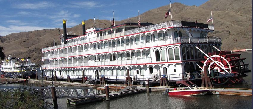
Port of Clarkston Comprehensive Scheme

TABLE OF CONTENTS
                                                      Page
Title Page
Cover Page                                               i
Table of Contents                                       ii
Introduction
   Mission of the Port                                  1
   The Comprehensive Scheme of Harbor Improvements      2
   History of Washington Ports                          2
    General Powers                                      3
    Transportation                                      3
    Economic Development                                3
  The Port of Clarkston                                 4
    Characteristics of Asotin County                    4
    Port Properties                                     7
  Port Planning Documents                               9
  Planning Assistance to the City of Asotin            11
Goals, Policies and Objectives for Port Development    12
Economic Development Initiatives                       19
  Preface                                              19
  Industrial and Commercial Infrastructure             20
  Transportation Infrastructure                        22
  Communications/Security Infrastructure               23
  Recreation and Tourism                               25
  Capacity Building and Other Broader Economic
   Development Initiatives                             25
Planned Improvements                                   27
  Near Term Recommendations                            27
  Medium Term Recommendations                          27
  Timing to be Determined                              27
  Timing That Is Opportunity Driven                    27
Comprehensive Scheme of Harbor Improvements            28
Appendices Lead Sheet                                  29
Appendices                                            30+

                                                             Page ii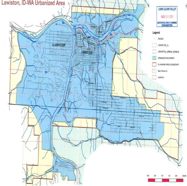
Port of Clarkston Comprehensive Scheme

INTRODUCTION

Mission and Core Values for the Port of Clarkston

  It is the mission of the Port of Clarkston to fully use its statutory authority to:

         Deliver property, facilities, and infrastructure that encourage private
         investment, create wealth for constituents, create family wage jobs,
         diversify and stabilize the local economy and create a sustainable
         environment;
         Play a leadership role in ensuring that waterfronts are vibrant, active
         centerpieces for the communities in the locality and partner on improving
         other tourism and recreation opportunities; and,

         Preserve and better the quality of life for the citizens of Asotin County

Values are traits or qualities that are considered worthwhile; they represent an organization’s priorities
and convictions. Value statements are grounded in principles which define the behavior of the
organization’s members.

The Commissioners affirm that the following core values define the actions and beliefs of the Port of
Clarkston:

Professionalism - To be responsible, accountable and respectful.
Transparency - Openness in planning and decision making; to provide full, accurate and timely
disclosure of information to the public.
Visionary - Creative use of ideas in order to craft a positive future; to be forward thinking by looking
for things that have not been done before and to have the foresight to anticipate the impacts of
decisions.
Sustainability - Reliance on local resources; to generate and distribute benefits locally, while
protecting long-term community interests.

                                                                                                    Page 1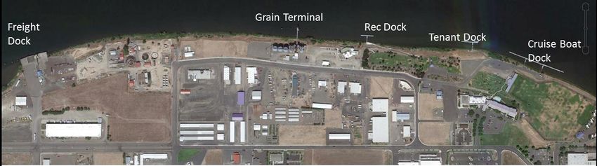
Port of Clarkston Comprehensive Scheme

Collaboration – Active cooperation, communication and development of productive working
relationships with community groups and government agencies by coordinating activities, sharing
resources and leveraging funding opportunities.
Integrity - Adherence to principles that represent the best interests of the community.

The Comprehensive Scheme of Harbor Improvements (Comprehen-
sive Scheme)
Developed as a tool for the Port of Clarkston and its constituents, this Comprehensive Scheme sets
the Port’s vision for the next six years. To realize that vision, it outlines a general scheme of harbor
improvements, meeting the requirements of Chapter 53.20 of the Revised Code of Washington State.

The original Comprehensive Plan was created in 1966. Since then, the guiding document of the Port
has undergone a number of revisions. Annual updates have occurred since 2013.

History of Washington Ports
In 1911, the state legislature enacted laws that allowed the people to establish port districts and elect
commissioners to administer the districts and oversee their development and operation. The Port
District Act of 1911 provided legal resolution to the long struggle to achieve public control over areas
that impacted the public through commerce.

While those laws have been changed from time to time since 1911, the most important provisions still
remain. Because they are public, but must operate in a proprietary way much like other type of
business, public ports are independent of other types of governmental authority except for state and
federal laws. They are “creatures of legislature” and a special form of local government. Formed by
a vote of the people they serve, ports are financed in part by property taxes paid by the people of the
district.

A port district, of and by itself, is a geographical area that may be as large as an entire county or as
small as a city or town. Its boundaries are defined when the district is formed.

Voted into being by an election of the people who live in the district, law creates Port districts as
“municipal corporations” of the state. Often referred to as “special purpose districts,” ports are
different from counties, cities and towns.

                                                                                                   Page 2
Port of Clarkston Comprehensive Scheme

Almost all powers of the port district are vested in a board of commissioners or “Commission.” Elected
from the district to serve six-year terms, the governing body of commissioners assures local control
and accountability. The port commission, like a city council or county commission, is the legislative
body responsible for making the policies and decisions of the district in both internal and external
matters. Such policies or decisions might involve adoption of plans, establishing positions, setting
employment policies, purchasing or disposing of real estate and other property, setting rates, adopting
budgets, levying taxes and many others. The commission appoints a chief administrative officer--
whose title at the Port of Clarkston is “Port Manager”--to administer the policies and decisions made
by the commission.

General Powers

Law allows port districts to develop many types of facilities to provide a variety of services. Most
easily identified are the various transportation-related amenities, such as marine terminals, storage
sites, and other direct transportation. Ports also deal directly with economic development, recreation
and tourism. See Appendix A for additional discussion of the powers of Port Districts.

Port activities do not need to center around navigation channels. Per Title 53.04 of the Revised Code
of Washington, port districts lacking appropriate bodies of water could still be formed and have all the
powers, privileges and immunities conferred on all other port districts.

Transportation

Marine Terminals. Terminals, a major part of many ports’ operations, provide for the movement of
ships, boats and barges in hauling goods and people in domestic and foreign commerce. These include
piers, wharfs, jetties, boat landings and equipment such as cranes for loading and unloading vessels
and barges. The Port of Clarkston’s water infrastructure supports movement of freight and also
movement of cruise boat passengers, creating commercial, tourism, and recreational benefits.

Storage Sites. Ports with marine terminals generally provide storage and processing facilities related
to the transfer of goods on water and land. These include warehouses, transfer places such as
container freight stations, and places for processing, freezing, storage and subsequent movement of
agricultural commodities, other perishable foodstuff, and other products in general. Some ports have
large domed structures for the storage of bulk metal ore, extensive land areas to store logs and lumber
awaiting shipment, and many ports have grain storage elevators.

Other Direct Transportation. Subject to the limitations by law, ports may operate certain railway
facilities. They may provide roadways, toll bridges, tunnels, highway approaches, canals, locks, utility
lines, telecommunications infrastructure, tramways, ferry service and passenger watercraft. The Port
of Clarkston is one of the few ports that owns roadways outside of an airport.

Economic Development

Law empowers Washington’s ports with broad economic development authority to bring business and
jobs to their communities. Almost every Washington port pursues an aggressive program of industrial
and economic development to promote employment and otherwise enhance the economy of the state
and district. Some ports deal with all aspects of the subject, others with only one or two. Ports may:

   •   Develop lands for industrial and commercial needs;
   •   Provide general economic development programs;
   •   Buy, lease and sell property;
   •   Provide air and water pollution control works;
                                                                                                  Page 3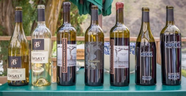
Port of Clarkston Comprehensive Scheme

   •   Operate trade centers and export trading companies;
   •   Establish and operate foreign trade zones;
   •   Promote tourism and recreation; and,
   •   Build telecommunications infrastructure and provide wholesale telecommunications services.

Economic development entities seeking to assist hometown businesses in being vital, growing and
firmly rooted, look beyond business recruitment to business retention and expansion activities to build
strong economies.

Port of Clarkston
As early as the 1870’s, before Washington was even a state, steamboats carried orchard and grain
products on the Snake and Columbia rivers to coastal markets in the west.

The Port of Clarkston was created in 1958, which
was 17 years before completion of the Lower
Granite Dam in 1975.         The dam enabled
shipments of agricultural and forest products
from the area via the Snake & Columbia rivers.

On September 9, 1958 during the state primary election, voters approved creation of the county-wide
Port district, with 2,252 voting in favor, and 588 voting against. The first meeting of the Port
Commissioners occurred on October 6, 1958. Emmett Johnson representing District #1 was elected
president of the commission, Earle Ausman representing District #2 vice-president, and Chalsey Floch,
representing District #3, secretary.

The Port of Clarkston is the farthest inland port in Washington State, located at river mile 137.8 of
the Snake River, approximately 460 miles from the mouth of the Columbia River. Prior to navigable
access, the Port focused on industrial development. The grain elevators on Port Way have been a
part of the landscape since the 1970s, with grain almost continuously shipped from that terminal since
the completion of the river system.

Tourism and commercial development related thereto, via cruise boats, is a niche market served by
the Port of Clarkston, with the number of tourists and support staff being served trending upwards
since the economic downturn in 2008.

Characteristics of Asotin County
Location

Bordered by 40 miles of Snake River to the east and to the north, Asotin County is in the southeast
corner of the state of Washington. The two incorporated cities in Asotin County, Clarkston and Asotin,
have been identified as part of the Lewiston, ID-WA metropolitan statistical area (MSA). The third
city in the MSA, Lewiston, Idaho, has a population that significantly exceeds the combined populations
of Clarkston and Asotin.

                                                                                                 Page 4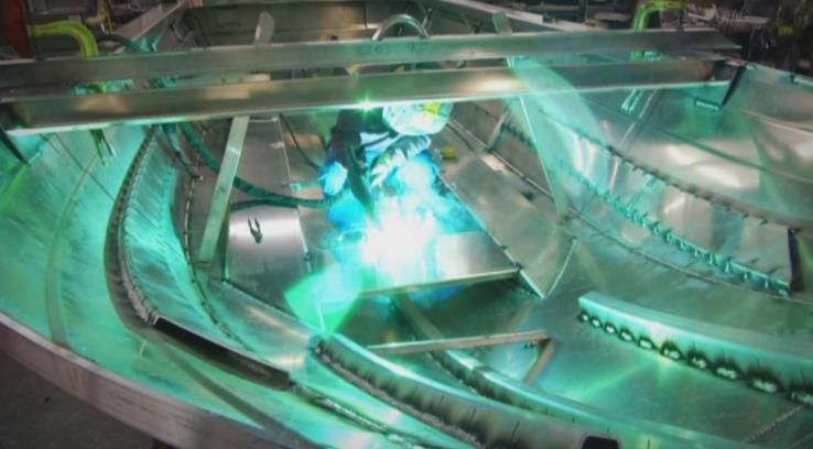
Port of Clarkston Comprehensive Scheme

Regional context
Asotin County, established in 1883, is in the farthest southeastern corner of Washington, bounded on
the east by Idaho and on the south by Oregon. Garfield County makes up its western border and part
of its northern border as well. The balance of its northern border is shared with Whitman County.
Before white exploration and settlement, the semi-nomadic Nez Perce inhabited what is now Asotin
County. Tribes on both sides of the Nez Perce Trail used it for commerce, which was of strategic
importance to the development of the region. Modern-day highways largely parallel the old trail.
The establishment of the territory and the end of the Indian Wars resulted in an influx of white settlers
into the county. Asotin, a former Nez Perce village, attracted settlers who were producing cattle, fruit
and vegetables for mining camps in Idaho by 1868. Most economic development in the county was
linked to mining activity in Idaho.
By the 1950s, agriculture dominated Asotin County’s economy with grain crops, such as wheat and
barley, as well as peas, berries, tree fruits and nuts, which were clustered near the river. The food
processing industry grew up around these crops and the meat and dairy farms.
The dense stands of fir in the Blue Mountains made lumber and wood products a growth industry.
Hunting and other outdoor recreation have been growth industries, too. The completion of the Lower
Granite Dam in 1975 shut down orchard and beef-processing activities along the river as land was
submerged, but it created one of the longest inland water routes in the nation. Agriculture remained
important, but now shared top billing with port activity at Clarkston-Lewiston and the federal U.S.
Army Corps of Engineers, which operated the dam. Population growth followed the port activity at
both Clarkston and Lewiston, fueling trade and service sectors catering to their needs.1

Asotin County is tied closely to Nez Perce County, Idaho. Together, the two counties make up the
Lewiston metropolitan area. Strong growth in manufacturing and a general economic expansion in
most sectors in both counties have provided residents of the port area with many job opportunities in
recent years, and pushed unemployment rates to record lows by 2017. Between 2000 and 2016,
nonfarm payroll jobs in Asotin County grew 15 percent, faster than the 9 percent growth in the U.S.
The sectors adding the most jobs since 2000 were retail trade, health services, professional and
business services, and manufacturing. Job growth allowed the county’s population to expand 9 percent
from 20,551 in 2000 to 22,307 in 2017.

1
    Source: Historic Glimpses of Asotin County by E.V. Kuykendall, Bob Weatherley of the Asotin County American
                                                                                                         Page 5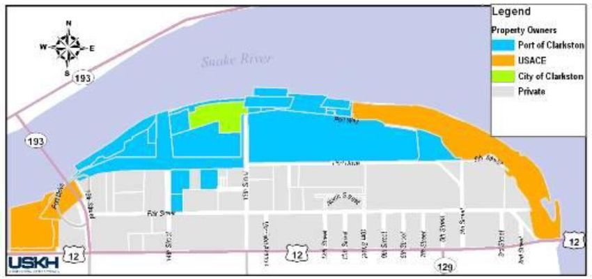
Port of Clarkston Comprehensive Scheme

Asotin County’s economy has thrived in recent years. Between 2013 and 2016, manufacturing added
120 jobs, health care added 90, construction added 80 jobs, and retail added 40. About half the
growth in manufacturing came from the expansion of jet boat builders, while the other half came from
the 2014 re-opening of the Bennett Lumber mill, which had been shut down for five years. Jet boat
builders, construction companies, health care, and retail have added more jobs so far in 2017.

Information presented below addresses Asotin County specifically. The composite of information
below shows economic trends and forecasts data to describe the overall direction of growth within
Asotin County and to set the context for development opportunities.

Local economy
Based on the Quarterly Census of Employment and Wages (QCEW), in 2016 overall employment grew
by 2.7 percent to 5,992, which was led by agriculture (12.9%), construction (0.6%), real estate and
rental and leasing (6.5%), health care and social assistance (5.8%), wholesale trade (3.2%), and
retail trade (2.7%). All these industries are moving forward with expansion and development due to
population demand for the services.

Population related services have been growing to accommodate a demand. However, services that
depend on many other factors are struggling, which includes: professional and technical services
(-5.6%), transportation and warehouse (-4.3%), information services (-3.1%), and leisure and
hospitality (-1.1 and -1.6% respectively).

Agricultural employment also continues to play an oversized role, not in terms of total employment,
but in terms of economic impact. High prices for wheat positively impacts wholesale sales employment,
retail sales and the overall quantity of money flowing through the economy.

Detailed employment and related demographic data can be found in Appendix B.

Fish and Dams
One of the major external constraints for local economic growth is the possibility of breaching the
dams on the Lower Snake River. Lower Granite Dam was completed in 1975, marking the last of the
navigable components in the Columbia/Snake River system and enabled waterborne commerce to run
460 miles between the Ports of Clarkston and Lewiston and the Pacific Ocean. It represents the
furthest inland water route in the United States.
In addition to barge traffic, the reservoir behind Lower Granite dam enabled substantial recreational
activities to occur including boating, rafting, and cruise ship visits, among other activities. The region’s
economy could be significantly affected by decisions about the dams.
In its May 4, 2016 Opinion and Order in Case 3:01-cv-00640-SI, National Wildlife Federation et al., v.
National Marine Fisheries Service, et. al., Federal District Court Judge Simon found that the U.S. Army
Corps of Engineers and U.S. Bureau of Reclamation violated the National Environmental Policy Act
(NEPA) in the process of developing a Biological Opinion in its management of the Federal Columbia
River Power System. The Court urged the agencies to take a full evaluation of reasonable alternatives,
up to and including, potential removal of the four lower Snake River dams. There is an indication that
federal agencies are taking this mandate seriously, but not limiting the scoping of the next NEPA to
simply the four lower Snake River dams.                      (More information can be found at:
https://www.salmonrecovery.gov/BiologicalOpinions/FCRPSBiOp/2014FCRPSBiOp/CourtDocuments.aspx)

Climate change, carbon-free energy generation, water shortages in the west, water storage
agreements under the soon-to-expire Columbia River Treaty with Canada and back-up power
generation may enter into the scope of the new NEPA analysis. In addition in 2018, Washington

                                                                                                      Page 6
Port of Clarkston Comprehensive Scheme
Governor Inslee’s Southern Resident Killer Whale Recovery Task Force has given dam breaching
advocates a forum to advocate for lower Snake River dam removal as a potential solution to
diminishing numbers of orca whales, promoting the incorrect assumption that breaching dams will
provide an immediate and significant benefit for whales. What is clear, though, is that the certainty
that the Snake River dams will be available in the future for assisting with the movement of freight
and providing tourism/recreational benefits to cruise boat passengers is lessening.
According to the Palouse Regional Transportation Planning Organization’s 2016 Palouse Regional
Freight Study, 97.5% of the wheat shipped from southeast Washington move by a combination of
truck and barge. If river transportation is no longer available to wheat producers in Asotin and
neighboring counties, it could have a significant impact on the economic situation in the region.
Based upon industry values for cruise boat visitors, passengers calling at the Port of Clarkston are
contributing over $2 million annually to the local economy, due to the availability of locks and dams
on the river system, as well as Port amenities. Without a river transportation system, there would be
no cruise boats.
Port Properties
The Port of Clarkston operates as both a landlord (managing Port-owned properties) and a property
developer where it has prepared land for development and makes it available for purchase. The real
estate and infrastructure the Port has managed for the benefit of its constituents has expanded
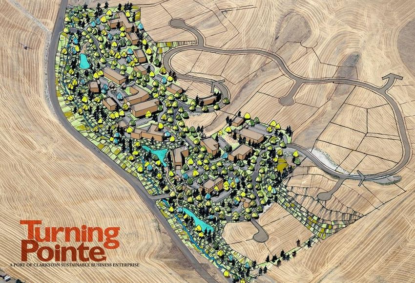
beyond the “historic port area” in north Clarkston to “Turning Pointe Business Park” in Asotin County
west of Dry Creek Gulch, off Evans Road (in Section 36). When completed in 2014, this new
industrial/business park made an additional 25.6 acres available for lease or sale.
Location west of Clarkston
Artist’s concept
In the historic Port District in north Clarkston, the Port owns 105 acres of land and 9 additional acres
underwater. Of the 105 acres of land, 87 are currently under lease, 5.4 are about to be committed
to a long-term lease, and an additional acre is under an option to lease. This leaves fewer than 10
acres of ground presently available for lease or sale in north Clarkston. At 6 acres of land and
contiguous to 7 acres under water, Parcel 8 on the map on the next page is the largest parcel of
significance available in the historic Port District.
Page 7Port of Clarkston Comprehensive Scheme
Map of parcels
Map of property ownership in n. Clarkston
Parcel 8
In addition to land it owns outright in north Clarkston, the Port leases 33 acres of land from the U.S.
Army Corps of Engineers (USACE) and an additional 13 acres under water (for the marina) for
tourism/recreational purposes. Some property shown in orange above—the southeastern portion--
however, is not leased by the Port and remains in operational use by USACE.
The Port owns several access points to the river and leases others along the Snake River in north
Clarkston. The freight dock on the north end of 14th Street and the land by the grain terminal used
for filling grain barges are owned by the Port (the grain terminal operates dolphins to support wheat
shipment). In addition, access for tour boats and a commercial boat tour operation are obtained
through leases between the Port and USACE. The day-use recreational dock and the marina with
boat launch access are also achieved through Port/USACE leases. River access points are shown on
the map below. Not shown on the map is the potential river access point north of the conclusion of
13th street, near the waste water treatment facility.
Map of River Access Points in North Clarkston, WA
Of the three Ports at or near the confluence of the Snake and Clearwater Rivers, the Port of Clarkston
has fewer multi-modal opportunities (no rail and less easy access to main highways) and more
sedimentation. However, the Port of Clarkston is the best suited of the three ports to accommodate
cruise boats given its easy access to amenities (hotel, winery, brewery and retail) within walking
distance of the 7th Street dock. The number of passengers and crew visiting the valley has been in
an upward trend since 2013, and that is expected to continue in 2019 and 2020.
Page 8Port of Clarkston Comprehensive Scheme
Port Planning Documents
COMPREHENSIVE PLANNING DOCUMENTS
The Port’s first “Economic Summary and Comprehensive Plan for the Clarkston Port District” or
Comprehensive Plan2 was prepared by Bovay Engineers for the Port of Clarkston in 1966. In 1999,
John Fratt completed an assessment of that Comprehensive Plan and recommended a revision, as
operations had changed enough at the Port of Clarkston to support the need for an update. In May
2001, BST Associates from Bothell, WA, created a new Comprehensive Plan.
Under that plan, the mission of the Port of Clarkston included five goals:
• Develop lands for industrial and commercial needs,
• Provide general economic development programs,
• Lease property,
• Provide air and water pollution control works, and,
• Promote tourism.
Under that plan, the Port also identified related objectives, including:
• To study and develop facilities for river transportation to deep-water ports downstream so that
Asotin County can share in the industrial and economic benefits of inexpensive river
transportation.
• Execute the various powers granted under RCW Chapter 53.083, including but not limited to
the acquisition and leasing of property related to economic development, and promotion of
industrial and commercial operations in Asotin County.
• To promote new and existing business and job opportunities.
• To promote intermodal transportation of commerce.
• To promote industrial and commercial development in such a manner as to preserve and
protect the general environment.
In July 2004, under Resolution 2004-07, the Port adopted revisions to the 2001 Comprehensive Plan
to expand and update the recreational component of the plan.
A new section, “Section 4. Financial Considerations” was added to the Port Comprehensive Plan by
Resolution No. 2006-01 of the Port Commission and passed on the 20th day of February, 2006. The
purpose of the amendment to the Comprehensive Plan was to record the change in accounting method
from accrual basis to the cash basis effective January 1, 2005.
RIVERFRONT MASTER PLAN AND PARKS AND RECREATION PLAN
In 2010, two additional planning documents were created subsequent to the 2006 revision to the
Comprehensive Plan, the Riverfront Master Plan for North Clarkston, Washington, and the Port’s Parks
and Recreation Plan. Both documents are hereby appended to this Comprehensive Scheme of Harbor
2
Note on terminology: Previous versions of the Port’s key planning document have been titled “Comprehensive
Plan.” The word “harbor” in the statutory language has a historical reference that dates back to when Ports’
primary purposes were directly marine-related. The terminology “Comprehensive Plan” has taken on new
meaning since the Growth Management Act was passed. Therefore, the Port of Clarkston has chosen to return
to the original terminology in authorizing legislation in titling this document as a “Comprehensive Scheme of
Harbor Improvements.”
3
The primary purpose of a port district is to promote economic development. The Legislature has given ports
broad authority to promote economic development by building and/or operating airports, railroads, industrial
development enterprises, and promoting tourism, among other things. See Appendix A.
Page 9Port of Clarkston Comprehensive Scheme
Improvements. (In the hard copy version of this plan, these reports can be found in Appendices D
and E, respectively. In the website version, they are located in separate electronic files, stored at the
same web location.)
Riverfront Master Plan Overview
The Riverfront Master Plan was completed in April 2010. Key strategies identified in that planning
process to foster the goal of creating an active, vibrant riverfront include:
• Encourage a cooperative partnership between educational, business, Tribal, and local
government that may result in creation of a seamless campus that runs north from Bridge
Street to the riverfront and out into the water.
• Encourage more “experiential manufacturing” near the riverfront east of 13th Street—a term
coined because not only does a manufactured process result, but visitors (tourists) can enjoy
an “experience” through interaction. Examples of “experiential manufacturing” are wine and
beer-making, glass-blowing and other artisan crafts, and creating specialty foods, including
value-added agricultural products.
• Seek multi-story professional office buildings, perhaps even with condominiums on the top
floors, to create higher concentration of use on/near limited waterfront property, particularly
on land near Walmart.
• Preserve the “working” waterfront, making assets on the river available for movement of
freight on the river system.
• Preserve transportation hub sector occurring near the waterfront, but concentrate such
activities west of 13th Street.
• In future leasing decisions, consider “highest and best use” (i.e., storage units—unless they
involve warehousing for on-the-water freight movement--do not need to be located near the
waterfront).
• Develop the new Sustainable Business Park to provide alternatives for heavier, more industrial
business purposes, due to small quantity of land currently available for development and to
support “highest and best use” decisions.
Accomplishments since April 2010 in these areas include completion of Turning Pointe Business Park
to encourage non-water dependent development away from the riverfront, for industrial and business
purposes, growing collaboration on improving amenities and experiences for cruise boat passengers,
expansion of leased building into retail/antique shops and investment in the grain terminal facilities.
Parks and Recreation Plan Overview
In June 2010, the Port of Clarkston created a stand-alone Parks and Recreation Plan that included
these priorities in the capital improvement plan:
Priority #1: Make continued improvements to Granite Lake Park including but not limited to a short-
term use recreational boat dock, retaining wall viewing areas, interpretive panels, path
upgrades, landscaping and lighting of pathways.
Priority #2: Install lighting along existing pathway east of Granite Lake Park to the Corps of Engineers
administrative office
Priority #3: Continue creating or improving bike/pedestrian paths and sidewalks along Port-owned
streets.
Priority #4: Design and construct a recreational trail feature in the Port of Clarkston’s new sustainable
business park.
Named within that plan were also un-prioritized projects requiring partnership with other entities (in
no particular order) including:
Page 10Port of Clarkston Comprehensive Scheme
• Skateboard Park (City of Clarkston project)
• Marina improvements (Hells Canyon Marina—formerly Red Wolf Marina, Asotin)
• Boat launch and other boating amenity improvements (Corps launch area)
• Acquire beaches south of Asotin (Asotin County Parks and Rec Advisory Committee)
• Bike trail enhancements to Chief Timothy Island
• Playground and/or multi-use ball/badminton court for Granite Lake Park
• More paved parking/pervious parking near riverfront at Granite Lake Park, end of 13th Street
or other appropriate locations
Accomplishments since completion of the Parks & Recreation Plan:
Since 2010, the Port has completed within Granite Lake Park the recreational boat dock, amphitheater
(aka retaining wall viewing area), access pathways, new park lighting, and new electrical outlets for
events within the park as well as on-going maintenance projects. The Port has also completed new
sidewalks along Port Way, 9th Street, and Port Drive from 9th Street to 13th Street. In addition, a
graveled pathway along Dry Gulch was completed as part of the construction of the new business
park off Evans Road. Also, support has been given to the City of Asotin as it relates to boat launch
restoration, as described below.
PLANNING ASSISTANCE TO THE CITY OF ASOTIN
In early 2013, the City of Asotin requested assistance from the Port of Clarkston with regard to
refurbishing its existing water facilities. These were constructed by the Corps of Engineers as part of
the Lower Granite pool recreational master plan. Since the Asotin’s water facilities are within Port
jurisdiction and relates to the Port goal of maximizing benefits from riverfronts, the Port has assisted
or made commitments to assist in these areas:
• Obtaining a 30-year or longer lease for land managed by the U.S. Army Corps of Engineers
(USACE) Walla Walla District and leased by the City of Asotin (needed because amenities
tapping grant funds in Washington had to be available to the public for 25 years after
completion);
• Assist the City in obtaining resources for redesign and construction, grant administration and
permitting; and,
• Getting the USACE land transferred into City of Asotin ownership.
By the end of 2014, the lease extension had been accomplished.
In 2015, the City of Asotin a planning grant for restoration of water facilities with the Washington
state Recreation & Conservation Funding Board, with focus on the boat launch and jetty redesign, as
well as permitting. This grant was administered with help from the Port of Clarkston and wrapped up
in 2017. In 2016, the Port assisted the City in obtaining additional planning funding from USDA Rural
Development, and that project is in the final stages of completion.
It is anticipated that the Port of Clarkston’s continued involvement with City of Asotin restoration of
water facilities will be of benefit to all constituents. As part of the grant match, the Port committed
assistance in obtaining permits before construction can begin, and that permitting is in progress.
Land ownership transfer language was approved in the Water Resource Reform and Development Act
(WRRDA) legislation in 2014. A fair amount of effort will need to be expended before the actual
transfer can take place. The Port has been assisting in this transfer.
Page 11Port of Clarkston Comprehensive Scheme
GOALS, POLICIES, & OBJECTIVES FOR PORT DEVELOPMENT
The Port of Clarkston Commission recognizes the importance of clearly defining the major goals,
objectives and policies of the Port and utilizing them to guide future port activity. Since port districts
are publicly owned, it is important to receive public input on port development to ensure ports are
targeting the needs and concerns of the district. Public opinion and input is important, nevertheless,
the Port Commission remains the final authority as to the content of this comprehensive scheme.
To obtain public opinion and input, public advertisement was placed in the Lewiston Morning Tribune
requesting comments, the draft comprehensive scheme was sent to local libraries and posted on the
port web site and a public meeting was held to discuss the 2019-2024 Port Comprehensive Plan. The
date and location of the meeting is listed below:
November 8, 2018 during a regular Port Commission meeting
Goals, policies, and objectives add flexibility to a Comprehensive Scheme of Harbor Improvements by
giving general directions for decision making, but not specific projects for achievement. At the same
time, goals and objectives provide a measure for evaluating and monitoring progress toward a desired
end.
The goals, policies, and objectives section contains three distinct elements:
(1) GOAL STATEMENT - A broad encompassing statement about a desirable
future attribute, trait, or condition to strive for.
(2) POLICY/OBJECTIVES STATEMENT - Specific target actions to be taken toward achieving the goal
and a general course of action to be pursued.
(3) FINDINGS - Information that explains the rationale behind each goal.
GOAL 1: Actively encourage diversification of the District’s economic base.
Policies/Objectives:
• Support the manufacturing sector through membership in, grant support for, technical
assistance to, and other support activities of the Northwest Intermountain Manufacturing
Association (NIMA), the American Manufacturing Network, Inc., AMN Solutions, LLC, the
regional metal “supercluster,” the Snake River Boat Builders Alliance and other networks of
manufacturers.
• Identify and assist in the development of new products, markets, and industries relying on the
human, organizational, educational, agricultural and natural resources of the region.
• Investigate the need for additional facilities for storage, handling, and processing of value-
added agricultural commodities and wood products.
• Undertake active recruitment of new economic activities and accelerate the Port’s involvement
in economic development activities in Asotin County’s communities.
• Promote tourism as a viable industry by advertising, publicizing or distributing in
cooperation/collaboration with Visit LC Valley information designed to attract visitors as
outlined by RCW 53.08.255 with emphasis on cruise boat passenger opportunities and the
Lewis-Clark Valley American Viticultural Area.
Page 12Port of Clarkston Comprehensive Scheme
• Initiate dialog with other public agencies, non-profit economic development organizations, and
the private sector to obtain and support industrial feasibility studies of potential regional
significance.
• Partner with local, regional and state economic development organizations in order to recruit,
retain, enhance and foster business and industry.
• Encourage entrepreneurialism and growth of new businesses or capacity building for existing
businesses through advising the entrepreneurship and business programs at Walla Walla
Community College, Lewis-Clark State College, and through financial institution advisory
committees, assisting with business plan competitions and providing other support for
emerging and growing businesses.
• Identify and follow-through with opportunities relating to feasibility or other studies for
emerging clusters and/or incubators.
• Seek opportunities to diversify the economy through renewable/sustainable energy business
growth and retention.
• Utilize powers granted by SSB 6675 and HB 2664 (RCWs 53.08) and subsequently authorized
(via Legislature) powers, and partner with local service providers, if invited and where feasible,
to provide wholesale high speed, broad bandwidth telecommunications infrastructure
throughout Asotin County.
• Actively explore the applicability thereto and benefits of creating an Industrial Development
District in accordance with RCW 53.25 and utilize, as needed, to accomplish economic
development objectives.
Findings for Goal 1:
Asotin County’s major industries are service, retail and government. The agricultural sector has been
and continues to decline in both employment and revenue generation. Workers are one of Asotin
County’s biggest exports. In 2016, approximately 56.8 percent of the wages earned by residents
were from outside the county (primarily Nez Perce County).
Service sector jobs have been the source of job growth in Asotin County. However, the jobs being
created are not family wage jobs. Youth and young adults contribute to the population in lesser
numbers than compared to elsewhere in the state, while the people aged 65 or older make up a much
more significant part of the population. To state it simply, we need more family wage jobs in Asotin
County to decrease out-migration of young people. It is the Port’s opinion that economic base
diversification, state of the art telecommunications, manufacturing cluster support and regional
collaborative approaches to economic development are some suitable paths to this goal.
GOAL 2: Support economic development facilities and services and coordinate
communication and partnerships with entities engaging in economic development
activities and communicate results to constituents.
Policies/Objectives:
• Undertake active recruitment of new economic activities both from inside and outside the District.
• Acquire feasible sites in Asotin County for cooperative development with interested communities
and firms. Initiate dialogue and work in partnership with other public agencies and the private
sector for economic development purposes.
• With community support, acquire and lease feasible single or multiple-use facilities in Asotin
County communities.
Page 13Port of Clarkston Comprehensive Scheme
• Explore the needs, costs and benefits of expanded cruise boat passenger terminal(s), revenue
streams such as passenger terminal fees, and related issues and implement in ways to assure
sustainability.
• Seek partnership with entities such as the Community Economic Revitalization Board (CERB),
Washington State University (WSU), the state legislature and regional state and federal
agencies/organizations to fund economic impact studies and needs assessments, and facilities and
services.
• Provide input on District and County needs to the Pacific Northwest Waterways Association
(PNWA) and the Washington Public Ports Association (WPPA).
• Monitor changes in water rights policies and laws as they may potentially impact business and
agricultural interests within the county.
• Assist or refer private business needs to agencies providing assistance and/or provide technical
assistance capacity-building support, as appropriate.
• Distribute promotional materials/websites/interpretive signs/presentations for the District and
County in general and develop promotional materials for Port facilities in particular.
Findings for Goal 2:
The Port holds capabilities as a general-purpose economic development agency and an off-water
industrial property developer. The Port acts as a liaison between private businesses and local, state,
and federal business assistance programs. It is a conduit to state and federal lobbyists. Therefore,
the Port needs to communicate with, and educate, the public about these capabilities. The Port must
continue to increase the coordinated, cooperative promotion of the area to prospective industrial
investors and firms. In addition, the Port needs to continue collaborative efforts to grow capacity in
advanced manufacturing and other sectors of the economy.
Some Port Districts have experienced success in coordinated, cooperative promotion through
development of Public Development Authorities (PDA’s) in local communities. PDA’s are made up of
local people investing in retail/medical services in their community. Port support for these activities
will benefit the Port’s mission. The Port will seek opportunities to partner on these types of projects.
GOAL 3: Continue acquisition, development and management of Port properties
and facilities, and where benefits are shown to exist consider disposition of assets
to ensure economic growth.
Policies/Objectives:
• Maintain a flexible leasing policy responsive to the needs of the District.
• Provide public port facilities as warranted by market demand.
• Work toward acquisition of additional acreage and buildings wherever needed or invited for
future Port expansion.
• Encourage maximum taxable tenant improvements at all Port sites.
• Incorporate proactive environmental planning with industrial, commercial and recreational
(including cruise boat) development including the riverfront.
• Update the aerial photos and maps of Port properties and facilities.
• Keep assets clean, safe, and attractive.
• Work with Asotin County, City of Clarkston and other local agencies with regard to stormwater
runoff issues.
Page 14Port of Clarkston Comprehensive Scheme
Findings for Goal 3:
In order for the Port to continue its success, it must continue acquisition, development and
management of all Port properties and facilities. Therefore, the Port must continue to nurture its
existing on-water and off-water sites and diversify its interests by exploring alternative locations and
approaches, such as microenterprise development in rural communities.
With the increasing challenges facing waterfront development as a result of the ESA listings of salmon
and steelhead and updated stormwater regulations, the Port must be forward thinking in its future
development plans and incorporate proactive methods for industrial development in balance with
watershed improvements and preservation, as well as commercial and recreational development on
the riverfront.
The Port has secured port security resources to assure safety of its properties in north Clarkston and
will provide adequate lighting and other security measures when it develops property elsewhere in
the County.
GOAL 4: Develop a telecommunications plan and infrastructure to facilitate
enhanced telecommunications services countywide.
Policies/Objectives:
• Develop telecommunications needs assessment, connectivity strategies and recommendations for
future network implementation projects for telecommunications infrastructure within Asotin
County.
• Work within the guidelines of SSB 6675 and HB 2664 (RCWs 53.08), a Senate bill passed in May
of 2000, allowing Ports and PUDs to build telecommunication infrastructure and offer it wholesale
to service providers.
• Work with Asotin County’s independent telephone companies, when invited and where feasible,
to create infrastructure that will help our local providers enhance telecommunications services
offered to rural communities.
• Work with the PUDs, Northwest Open Access Network (NOANet), Bonneville Power Administration,
Port of Whitman, Port of Lewiston, other agencies building telecommunications infrastructure and
internet service providers to provide and link networks that will reach in and out of Asotin County.
• Build transmission and “bricks and mortar” type facilities for lease in Asotin County that will
encourage telecommunications companies to provide enhanced services in rural Asotin County.
• Where possible, tap state and federal resources to support this goal.
Findings for Goal 4:
The Port of Clarkston has adopted the Port of Whitman model whereby partnerships are formed with
multiple telecommunications carriers that provide broadband choices for citizens in their jurisdiction
through the lease of dark (unlit) fiber optic cable. The Port of Clarkston is building on Port of Whitman
and NOANet middle mile solutions to assure enhanced services in Asotin County.
The Port will continue to look for creative ways to develop infrastructure, form partnerships and link
networks in order to provide affordable, state-of-the-art telecommunications opportunities through
the Asotin County telephone providers and their respective small service bases.
Page 15Port of Clarkston Comprehensive Scheme
GOAL 5: Encourage a balanced and economical multi-modal transportation
system serving agriculture, commerce, industry, recreation and tourism.
Policies/Objectives:
• Advocate for and maintain adequate navigation and amenities for the cruise boat industry.
• Advocate for and maintain adequate navigation and amenities for freight-by-river movement.
• Continue advocacy for maintaining the Columbia/Snake River channel as a transportation system.
• Recognize that all modes of transportation are important with emphasis being shifted from time
to time depending on needs of the District.
• Formally participate in the metropolitan planning organization, regional transportation planning
organization and state transportation planning on a regular basis to preserve and enhance
transportation systems.
Findings for Goal 5:
The cruise industry continues to grow and the role of moorage in the Lewis-Clark Valley has become
increasingly important since passenger change-out was initiated in 2015. On Sept. 26, 2017, maximum
capacity at the Port was reached with three boats moored at the cruise boat dock and one at the
freight dock. Reservations for moorage for 2018 indicates that maximum capacity will be constrained
going forward. One cruise line with two boats on the system is expected to add a third in 2019. Back-
up amenities need to be developed as a) capacity continues to be constrained and b) sediment builds-
up at the Port of Clarkston cruise boat dock. The planned economic impact study and needs
assessment will guide decision-making.
Advocacy is continually needed for sustaining and maintaining the dams and navigable channel,
including adequate appropriations. The Port engages in this effort with assistance from and
membership in the Pacific Northwest Waterways Association, Northwest River Partners and the Inland
Ports Navigation Group.
Port staff have served on the Palouse Rural Transportation Planning Organization (PRTPO) Board, as
well as the Lewis-Clark Valley Metropolitan Planning Organization Technical Advisory Committee, to
facilitate partnerships, exchange information and advocate for transportation solutions, where
needed. Emphasis on the local level has been on traffic flow, walkability, and improved bike and
pedestrian amenities.
GOAL 6: Develop and maintain recreational facilities physically and operationally
in recognition of the importance of recreation to the health and quality of life of
citizens within the Port District.
Page 16Port of Clarkston Comprehensive Scheme
Policies/Objectives:
• Continue to make improvements to existing recreational facilities including but not limited to
retaining wall viewing areas, interpretive panels, path upgrades, landscaping and lighting of
pathways.
• Create new recreational opportunities where compatible with commercial and industrial
development goals (for example, a trail system at the Sustainable Business Park).
• Investigate opportunities to increase income and reduce costs while continuing maintenance of
the park, marina, trails and other facilities.
• Continue to support recreational facility/economic development riverfront projects at the City of
Asotin.
Findings for Goal 6:
Historically, operations and maintenance revenues have been able to support Port activities including
the continued operation and maintenance of Granite Lake Park, dock and amphitheater. Creating
recreational opportunities at the Sustainable Business Park will increase costs for operations and
maintenance, even though the Port is seeking waterwise and limited maintenance solutions.
Therefore, operations revenues may not be sufficient to cover the costs of recreational amenities.
However, availability of recreation facilities can aid in creating an attractive environment which will
aid business recruitment efforts and business retention efforts for the District and region at large.
Therefore, it is acceptable to move forward on this goal, even if tax revenues must be tapped to
maintain the amenities. Marinas at the City of Asotin and near Red Wolf Bridge continue to need
attention.
GOAL 7: Maintain the District’s fiscal ability to provide needed resources and
services to all constituents.
Policies/Objectives:
• Consider implementing assessment of passenger boat terminal fees to decrease the subsidy the
Port of Clarkston provides to the cruise boat industry.
• Periodically review long-term lease rates to consider the impacts of inflation, the needs of the
District, and the competitiveness of leases and apply inflationary adjustments (generally CPI)
consistently, whether leases are monthly or long-term.
• Periodically review the best use of excess or inactive properties and consider their sale to fund
capital projects.
• Strive to manage 100% of operations and maintenance costs within revenue received for
operations. This will thereby preserve tax revenues, to the extent possible, for asset- and capacity-
building.
• Maintain record-keeping on cash basis of accounting.
Findings for Goal 7:
Historically, Port policy has been to conserve the District’s money and not require more taxes beyond
what was originally authorized. The Port has worked hard to cover maintenance and operations
expenses with operational revenues, including the cost of maintenance dredging. Existing tax
revenues support the creation and/or acquisition of new public assets. The new Sustainable Business
Park, at an investment of roughly $4 million, has been one of the biggest projects undertaken by the
Port in recent years. (The amount of $4 million is more than ten years of tax revenues for the Port
of Clarkston.) The Port’s total investment in new capital projects exceeded $7.6 million from 2009
through most of 2018.
Page 17Port of Clarkston Comprehensive Scheme
The Port has worked hard to secure grants and loans so that it was not necessary to increase the
taxes paid by constituents. Grants secured from 2009 through most of 2018 for capital and non-
capital projects exceeded $3.9 million. As a result of the achievement of two fiscal goals—responsible
management of resources and growing the tax base--the tax levy rate for the Port has decreased by
14% in the last decade.
SUMMARY: In establishing these goals, policies and objectives, the Port of Clarkston hopes to set a
realistic and achievable course for the next six to ten years. The Port has written these goals broadly
in order to maintain flexibility while identifying priorities, targeting actions and providing information
behind the rationale for each individual goal.
Page 18Port of Clarkston Comprehensive Scheme
ECONOMIC DEVELOPMENT INITIATIVES
Preface
Location overview: Assets owned by the Port of Clarkston are generally located in north Clarkston
(north of Bridge Street) or in “Turning Pointe,” the sustainable business park south of Ben Johnson
Road and west of Evans Road in Asotin County. However, projects on the horizon, particularly capacity
building projects, are not limited to those two locales.
CAPITAL PROJECTS:
Completed projects: The following is a list of infrastructure projects the Port of Clarkston has
completed within the last five years (2013 – most of 2018):
Grant/loan
Project Title Type of Project Public Investment Status of Project
assistance
Purchase/renovate
Building
building at 1335 No $ 225,285 Completed
improvements
Port Drive
Expand Port
Infrastructure Yes 294,202 Completed
Security System
Expand shop Infrastructure No 74,075 Mostly complete
Granite Lake Park Infrastructure No 59,191 Completed
Purchase vehicles Equipment No 26,511 Completed
Building
Shelter for F&W No 37,137 Completed
improvements
Turning Pointe
Infrastructure Yes 4,031,637 Completed
Business Park
Business Incubator Planning Yes 64,000 Completed
Purchase mower Equipment No 12,719 Completed
Phases 1, II, & III—
Telecommunications Infrastructure Yes 733,288 Completed
Infrastructure
Expand Riverport
Brewing Company Building
No 260,514 Completed
building & pave improvements
parking lot
Sidewalk
improvements in Transportation Yes 363,355 Completed
historic port district
Replace cruise boat
Infrastructure No 122,462 Completed
docks
TOTAL $ 6,303,870
Planned for 2019: Within the budget for 2019 are the following projects:
Page 19Port of Clarkston Comprehensive Scheme
773 - Capital Projects carried over from 2018
• Shop expansion--loft for records storage
773 - New Capital Projects in 2019
• Port Security system upgrades
• More cruise boat dock section replacement plus match on an economic impact study and needs
assessment
• Expansion of telecommunications infrastructure
• Costs associated with maintain approx. 50 feet from Port docks to navigation channel (may include
sediment sampling, permitting, engineering and sediment removal)
• Match assistance to Regional Stormwater Grant application for infrastructure replacement
Discussed as “being on the horizon” in the 2019 budget narrative were these capital projects:
• Potential to purchase existing buildings: Current tenants, at various times, have offered to the
Port for purchase buildings constructed on Port ground. In addition, other buildings being offered
for sale in 2019 may present opportunities for the Port to expand its inventory of buildings. The
Port recognized these opportunities in the text of the budget narrative but did not set aside a
specific amount for such purchase(s).
• Acquiring additional land and buildings—private property: The Port desires to acquire one parcel
of property in north Clarkston that is bounded on three sides by Port property. While terms for
acquisition are not favorable today, those circumstances could change and the Port may wish to
acquire that specific parcel, or potentially other parcels, to help advance economic development
objectives. Another, separate opportunity is being discussed relating to a parcel where land and
buildings are involved.
• Constructing a multi-tenant or incubator building: Alternatively, a new multi-tenant facility on
port-owned ground is likely to meet the needs of that tenant, as well as future new tenants.
Industrial and Commercial Infrastructure
A – Development Overview
Description: The original industrial and commercial infrastructure owned by the Port of Clarkston
since the 1960s is in the Clarkston city limits, north of Bridge Street. It consists of land, buildings on
Port owned land, roadways, water, and sewer. The original improvements did not come together as
a named development, except that most of the land used to be the old airport. Therefore, this section
of properties and projects within north Clarkston are collectively referred to as the Historic Port District.
In 2014 and 2016, improvements within “Turning Pointe,” the new business/industrial park west of
the populated area of Clarkston and Clarkston Heights off Evans Road, were completed, making more
improved property available for business development.
Purpose: The primary purpose for Port-owned land is to promote commercial and industrial
development. Land is available for lease in north Clarkston and for lease or sale in Turning Pointe.
Also, on some properties, buildings have been available for lease. Although some tenants have
requested the ability to purchase land, the Port has thus far declined to make sales of any land north
of Port Drive. In the opinion of the present Port Commissioners, land on the water, in particular, is
hard to replace.
Page 20You can also read