Bowditch Point Preserve - 50 Estero Boulevard Fort Myers Beach Land Management Plan - Lee County
←
→
Page content transcription
If your browser does not render page correctly, please read the page content below
Bowditch Point
              Preserve
                 50 Estero Boulevard
                  Fort Myers Beach

             Land Management Plan
                     2018

                     Second Edition

               Prepared by the Land Management Section

                         Parks & Recreation

Approved by Lee County Board of County Commissioners: 03/06/2018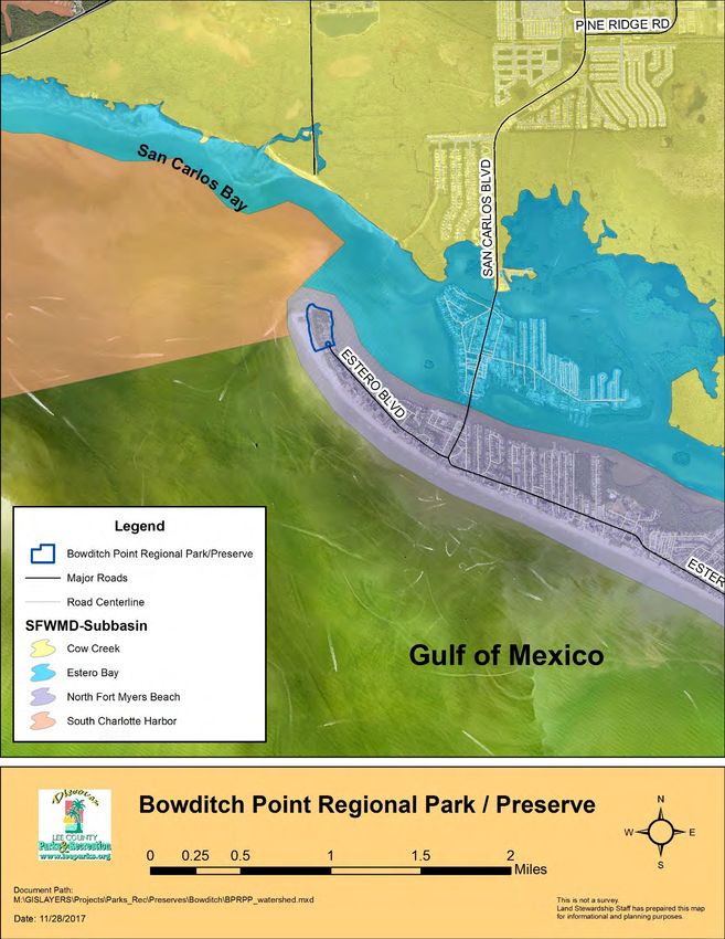
Acknowledgements:

This document was prepared with the assistance of Lee County Conservation
Lands Coordinators and Supervisors, Lee County Parks and Recreation staff and
Lee County Bird Patrol.

Many Thanks for your Time and Talent,

Terry Cain
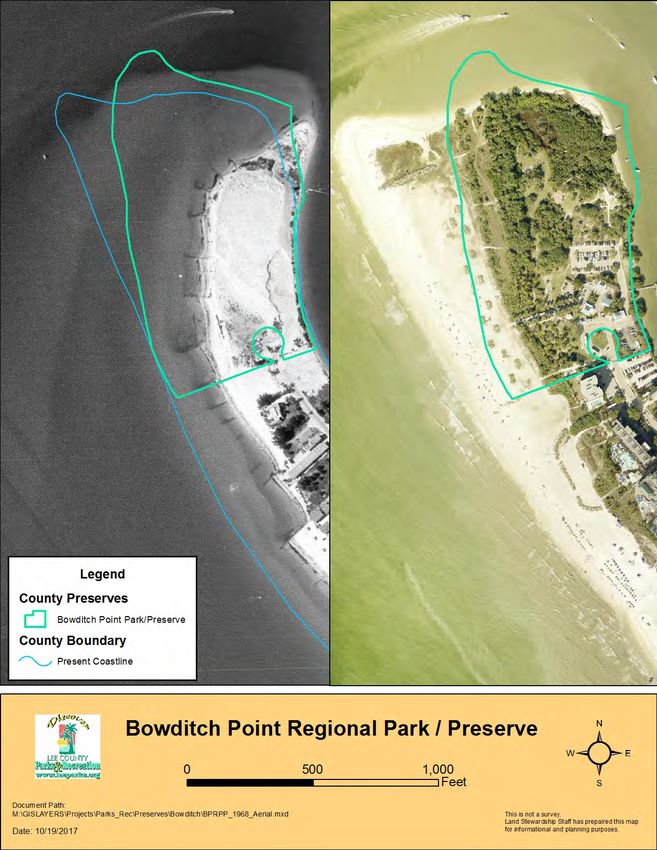
Table of Contents

VISION STATEMENT ........................................................................................... 1

I. EXECUTIVE SUMMARY .................................................................................. 2

II. INTRODUCTION ............................................................................................. 4

III. LOCATION AND SITE DESCRIPTION........................................................... 5

IV. NATURAL RESOURCES DESCRIPTION...................................................... 8

   A. Physical Resources ..................................................................................... 8
      i. Climate ....................................................................................................... 8
      ii. Geology..................................................................................................... 8
      iii. Topography .............................................................................................. 8
      iv. Soils ....................................................................................................... 10
      v. Hydrologic Components and Watershed ............................................... .12
   B. Biological Resources ................................................................................ .14
      i. Ecosystem Function................................................................................. 14
      ii. Natural Plant Communities ..................................................................... 14
      iii. Fauna ..................................................................................................... 19
      iv. Designated Species ............................................................................... 20
      v. Biological Diversity .................................................................................. 21
   C. Cultural Resources .................................................................................... 21
      i. Archaeological Features .......................................................................... 21
      ii. Land Use History..................................................................................... 22
      iii. Public Interest......................................................................................... 27

V. FACTORS INFLUENCING MANAGEMENT ................................................. 28

   A. Natural Trends and Disturbances .............................................................. 28
   B. Internal Influences...................................................................................... 28
   C. External Influences .................................................................................... 29
   D. Legal Obligations and Constraints ............................................................. 32

                                                          i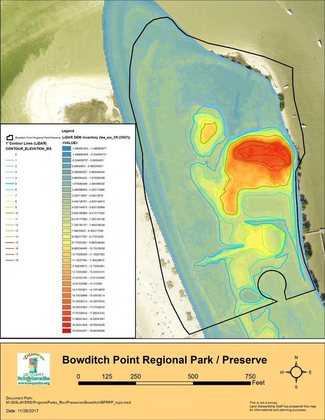
i. Permitting ................................................................................................. 32
      ii. Other Legal Constraints .......................................................................... 32
      iii. Relationship to Other Plans.................................................................... 32
   E. Management Constraints ........................................................................... 34
   F. Public Access and Resource-Based Recreation ........................................ 34
   G. Acquisition ................................................................................................. 37

VI. MANAGEMENT ACTION PLAN ................................................................... 40

   A. Management Unit Descriptions .................................................................. 40
   B. Management Work to Date ........................................................................ 42
   C. Goals and Strategies ................................................................................ 42

VII. PROJECTED TIMETABLE FOR IMPLEMENTATION................................. 45

VIII. FINANCIAL CONSIDERATIONS................................................................ 46

IX. LITERATURE CITED ................................................................................... 47

X. APPENDICES ............................................................................................... 48

                                                          ii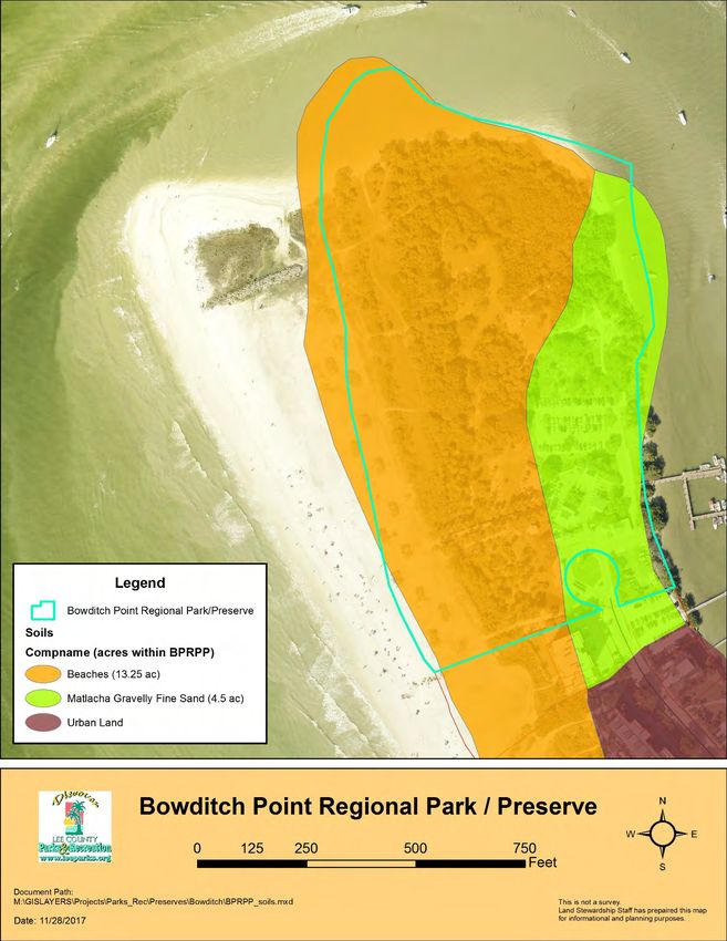
List of Figures

Figure 1: Location Map ........................................................................................ 6
Figure 2: 2017 Aerial View ................................................................................... 7
Figure 3: Topographic and LiDAR Map................................................................ 9
Figure 4: Soils Map ............................................................................................ 11
Figure 5: Watersheds Map................................................................................. 13
Figure 6: Plant Communities Map ...................................................................... 18
Figure 7: 1953 Aerial........................................................................................... 23
Figure 8: 1958 Aerial.......................................................................................... .24
Figure 9: 1968 Aerial Compared with 2016 Aerial .............................................. 25
Figure 10: 1998 Aerial Compared with 2016 Aerial ............................................ 26
Figure 11: Internal Influences Map .................................................................... 30
Figure 12: External Influences Map .................................................................. 31
Figure 13: Public Amenities/Master Site Plan Map ............................................ 36
Figure 14: Future Land Use Map ....................................................................... 38
Figure 15: Zoning and STRAP Map ................................................................... 39
Figure 16: Management Units Map .................................................................... 41

                                             List of Tables

Table 1: Management Work Summary (2007-2017)……………………….……... 3
Table 2: Bowditch Point Preserve Soil Types…………………………………….. 10
Table 3: Bowditch Point Preserve FNAI Plant Communities………………..…... 17
Table 4: Projected Timetable for Implementation..……………………………….. 45

                                                        iii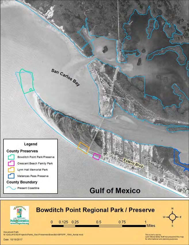
Acronyms

ADA      Americans with Disablities Act
BOCC     Board of County Commissioners
BPP      Bowditch Point Preserve
BPRP     Bowditch Point Regional Park
FDACS    Florida Department of Agriculture and Consumer Services
FDEP     Florida Department of Environmental Protection
FLU      Future Land Use
FLUCCS   Florida Land Use Cover and Forms Classification System
FNAI     Florida Natural Areas Inventory
FWC      Florida Fish and Wildlife Conservation Commission
IRC      Institute for Regional Conservation
LCPR     Lee County Department of Parks and Recreation
LSOM     Land Stewardship Operations Manual
LiDAR    Light Detecting and Ranging
NGVD     National Geodetic Vertical Datum
PPs      Photo Points
STRAP    Section-Township-Range-Area-Block.Lot (Parcel)
USFWS    United States Fish and Wildlife Service

                                  iv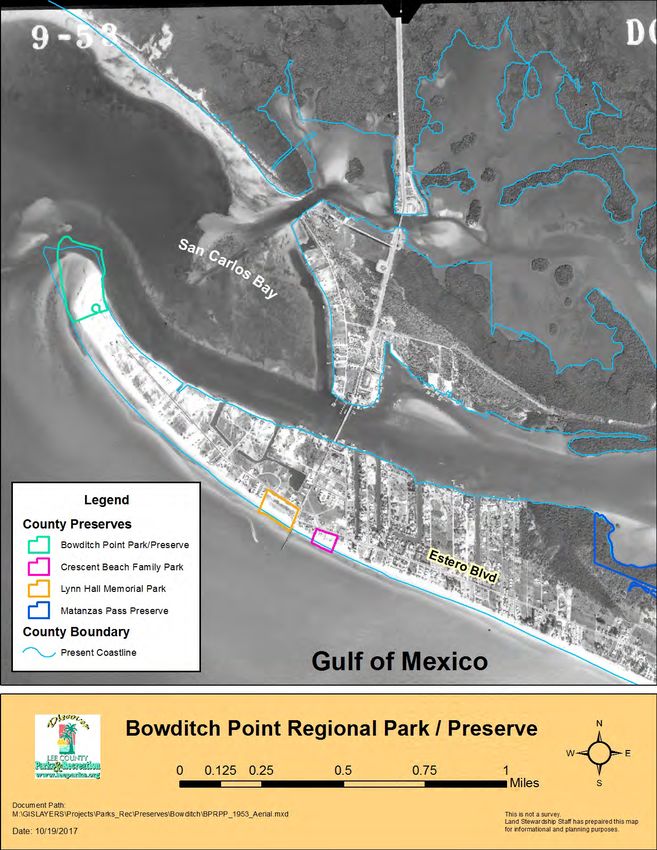
Vision Statement

It is the vision of the Lee County Board of County Commissioners, Lee
County Department of Parks and Recreation and Conservation Lands
  staff to ensure the preservation and restoration of Bowditch Point
                                Preserve.

    Preserved as an area that will continue to provide memorable
  experiences for visitors, Bowditch Point Preserve will continue to
 provide viable wildlife habitat for avian and land - based creatures.

  Guided nature walks, wildlife viewing from trails along the Gulf of
   Mexico and San Carlos Bay, photography of scenery and wildlife,
  canoeing, kayaking, fishing, swimming, and hiking are some of the
      resource-based opportunities at Bowditch Point Preserve.

    Maintaining a variety of ecosystems with exotic plant control,
  conservation education, and continued native plant restoration will
provide an outstanding educational experience in this versatile outdoor
                 classroom for residents and visitors.

                                  1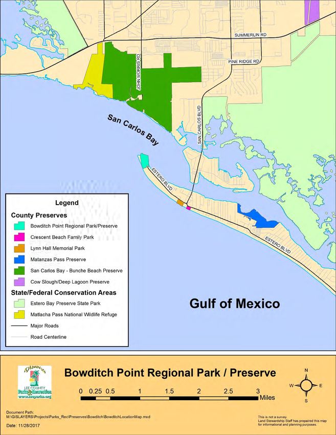
I. Executive Summary

Bowditch Point has had famous owners and was historically known as the “short end” by
residents and visitors. In 1895, James M. Bratt homesteaded the area also known as the
government lighthouse reservation, as other homesteaders moved into palm-thatched
chickees on the island. While the government may have anticipated a lighthouse at this
site, there is no evidence a lighthouse was ever constructed. By the 1930s, Barron Collier
owned the north end of Estero Island as well as other sites in Lee County. Tom Phillips
purchased the old government reservation on Bowditch Point from Barron Collier’s estate
in 1948, expecting to create the “Coney Island” of Florida on Fort Myers Beach. If Mr.
Phillips were alive today, he may have seen his dream come true for Estero Island (Fritz
1963).

In the early 1970s Bowditch Point was the only large undeveloped property on Estero
Island that had shoreline on both the Gulf of Mexico and San Carlos Bay. This point of
land was utilized to deposit spoil from channel dredging which led to the area having the
highest point on the island of 18 feet.

There was an attempt to develop the property in the 1970s and a seawall was
constructed. Today portions of this seawall are visible while walking to the beach and
over some of the nature trails. It is now quite a distance from the water due to sand
accretion from dominant east to west longshore drift. This accretion built up the land,
which became covered with both native and exotic vegetation. Beach dynamics continue
with the northernmost point of the shoreline eroding along with an area toward the bay
side of the island.

In 1987, the owner of Bowditch Point offered the land for sale with an assigned residential
density of 155-units as well as direct access to Estero Boulevard and more than 1,000
feet of Gulf of Mexico beachfront. Lee County Board of County Commissioners were
offered an option to buy within a timeframe that would expire December 1987. The owner
received another offer in November because Lee County was unable to secure a funding
source. In mid-December 1987, Lee County Board of County Commissioners secured
funding and purchased Bowditch Point for $5,750,000.00.

The goal of this land management plan is to guide future development of public facilities,
restoration, and preservation of Bowditch Point. A balance for the needs of the public
while also creating protection for the natural resources is a major component of the
management plan.

Natural disasters, winds, tides, and longshore drift are elements to be considered in the
management plan and will have a direct impact on how the plan is implemented. Any
landing areas for boats in future plans will be influenced by tides and erosion.

                                            2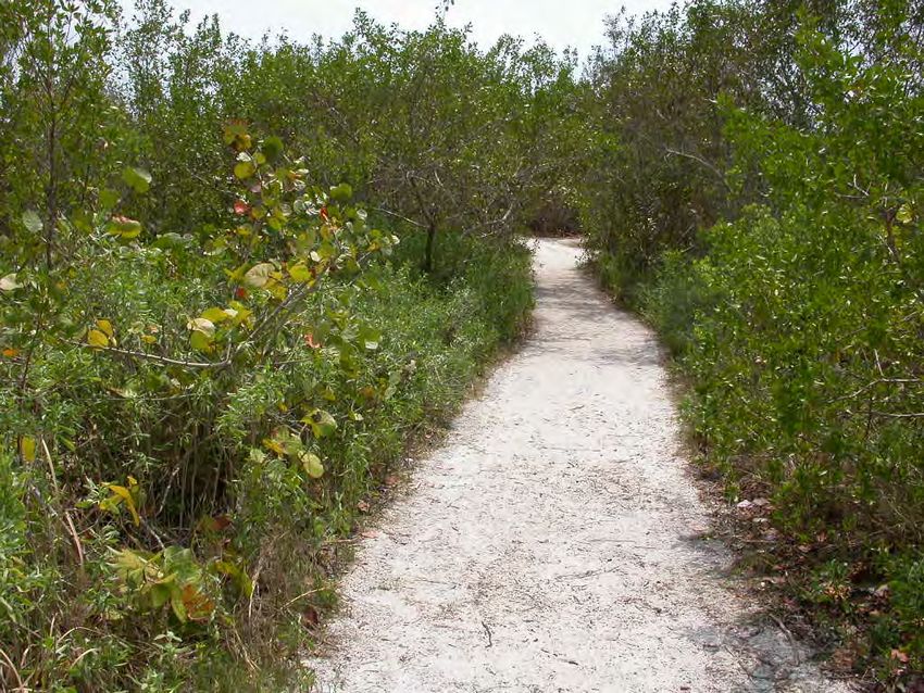
The topographical features of the preserve consist of typical barrier island slope to the
beach and bay as well as a manmade dredge spoil mound in the center of the Preserve.

Because of diverse vegetation and topographical features, the Preserve supports a
variety of wildlife year-round as well as resting and loafing areas for migratory bird
species.

Lee County Bird Patrol is a volunteer group that currently counts birds at Bowditch Point
Preserve and submits their information to ebird.org. The group is composed of
conscientious individuals who also monitor other wildlife and human impacts. The
documentation this partnership provides will ensure conservation efforts at the Preserve.

This plan will detail the projects of the last 10 years and what is planned for the next 10
years.

Table 1: Management Work Summary (2007-2017)

  Natural Resource Management

  Invasive exotic plant species have been treated throughout the Preserve, which is now
  at maintenance level. This work was completed in house by staff and with volunteers.

  Overall Protection

  Debris is continually removed from the Preserve by staff and volunteers.

  Tri-annual site inspections have been conducted.

  Public Use

  The day dock has been completed and is in use.

  The number of guest visiting the Preserve was 414,345 from October 2016 to September
  2017. This number only captures the guest arriving by car and does not include the
  people arriving by foot, boat, or trolley.

  Volunteers

  Volunteer groups, students, and community service workers have assisted in trail
  maintenance, exotic plant control, and debris removal.

  Trained volunteers lead weekly guided walks along the beach and trail systems during
  the winter season.

  During the winter season, there are weekly sunset sing alongs held on the lower patio led
  by volunteers.

                                            3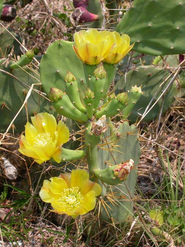
II. Introduction

Bowditch Point Preserve (BPP) is located within Bowditch Point Regional Park (BPRP)
that is located in the Town of Fort Myers Beach on the northwest end of Estero Island,
Lee County. This point of the island exists due to years of accreted sand from longshore
drift.

In this document, the site will be called by various names. Bowditch Point refers to the
time before the point was purchased by the county. Bowditch Point Regional Park refers
to the entire area after the purchase by Lee County and Bowditch Point Preserve refers
to the area that has been restored or left in a natural state.

Sand is always on the move, which is typical of barrier islands. Bowditch Point historically
was known to residents as the “short end”, since that time the name on maritime charts
has been used, Bowditch Point. Bowditch Point was named after Nathaniel Bowditch, a
world-famous mathematician and navigator who is credited as the founder of modern
maritime navigation. His book The New American Practical Navigator, first published in
1802, is still carried on board every commissioned U.S. Naval vessel (wikipedia.org).

In 1987, the Lee County Board of County Commissioners obtained an option to purchase
Bowditch Point for $5,750,000.00. The Board’s decision on the source of funding for this
acquisition was a very confusing process, which took eight months. This option was to
expire on December 31, 1987. In November 1987, the Board was informed the owner
had received another offer that he would accept if the County did not exercise its option
by the deadline. To facilitate closing on the property by the deadline the Board increased
the capital budget by $6,500,000.00 in proposed bond revenues. This represented the
acquisition price, $100,000.00 to begin design and the associated bond cost. In essence,
the Board loaned itself the money for acquisition from funds budgeted to other projects
that would not be spent during a specific timeframe. In July 1988, ad valorem funds were
used in place of the short-term loan. The Bowditch Point purchase took place December
22, 1987 and kept this parcel of land from being developed into homes or condominiums
(Appendix A).

Lee County began ecological restoration and exotic plant control in 1987. The removal of
Australian pines and Brazilian pepper opened up the Preserve and created walking paths.
Many of the same paths exist today and exotic pest plants are monitored and controlled.

Dedication of Lee County’s Bowditch Point Regional Park on the west end of Estero Island
was held on February 23, 1994 with several hundred people attending. Introduced at the
dedication was the first phase of park construction developed with public charrettes
(gathering of the public for collaborative design comments). The first phase, costing an
estimated $1,512,900.00, consisted of 15 picnic areas among coconut palms, a

                                             4
bathhouse with rest rooms, 10 tables on the village commons deck and a boardwalk to
the beach.
A limited parking area with 14 spaces was available to people with disabilities, the staff,
and the general public, who could obtain parking passes in advance of their visit. Primary
access to the Preserve was by biking, walking, boating, or by riding the beach trolley to
the stop at Bowditch Point Regional Park. A new parking area with 63 spaces including
three Americans with Disabilities Act (ADA) spaces was constructed in 2002. Major exotic
plant control and new native vegetation installation was completed in 2002 in concert with
the construction of the new parking area. Previous restoration has created improved
habitat as well as new habitat for wildlife.
Maintenance for this site is divided into operations and land management; both are
located in the Department of Parks & Recreation. Lee County Parks & Recreation
operations takes care of the entire site and conservation lands shares the responsibility
of the Preserve area. Only conservation lands management, expended and projected
cost are reflected in this document.
The purpose of this Management Plan is to update the 2007 Plan, and to define the
conservation, restoration and preservation goals for Bowditch Point Preserve for the next
10 years. It is a guide to support the best management practices for Lee County’s
Department of Parks and Recreation (LCPR).
III. Location and Site Description
Bowditch Point Preserve is located at 50 Estero Boulevard, Fort Myers Beach, Florida,
on Estero Island in southwest Lee County within Section 24, Township 46 South, and
Range 23 East. The Preserve is located at the western most point of the seven-mile long
island of Estero. Bowditch Point Regional Park is a 17.95 - acre Park and Preserve
surrounded on three sides by water, to the east and north by San Carlos Bay and to the
west by the Gulf of Mexico. The Park area has facilities that include a parking area,
restrooms-changing facilities, and outdoor showers available on the raised deck. Picnic
tables and grills are in palm-shaded areas with wildlife viewing throughout the Park and
Preserve. The Preserve is accessible from the south via Estero Island’s main road,
Estero Boulevard, which enters into a roundabout with an entrance to the west and paid
parking (Figures 1 & 2).
The northernmost part of the Park is where the Preserve is located with native plants and
local wildlife in five natural plant communities: beach dune, coastal grassland, coastal
strand, mangrove swamp, and a restoration natural community area. These community
designations are based upon Florida Natural Areas Inventory’s Guide to the Natural
Communities of Florida (FNAI 2010). Natural plant communities support a variety of
wildlife on land and in the estuary that enhance wildlife viewing and other beach-related
activities for residents and visitors.
5Figure 1. Location Map
6Figure 2. 2017 Aerial Photograph
7IV. Natural Resources Description
A. Physical Resources
i. Climate
General information on the climate of southwest Florida is located in the Land
Stewardship Operations Manual’s (LSOM) Land Stewardship Plan Development and
Supplemental Information section that can be found at:
http://www.leegov.com/conservation2020/documents/LSOM.pdf
ii. Geographic Features
Specific information on the geologic features such as physiographic regions, formations
and maps can be found in the LSOM’s Land Stewardship Plan Development and
Supplemental Information section.
iii. Topographic Features
Topographic maps are the two dimensional representations of the three dimensional
surfaces of the earth. Topographic maps depict elevations of land starting at its height
above sea level. Contour lines represent land surface elevations on topographic maps.
A contour line is a continuous, connecting line of an area that indicates the elevation of
the land above sea level within the line.
The elevation of the site ranges from zero to eighteen feet (Figure 3). A majority of the
site falls between zero and four feet in natural elevation where the beach areas rise out
of the Gulf of Mexico and San Carlos Bay. The dramatic elevation rise within the Preserve
is related to the early 1970s when Bowditch Point was the only undeveloped property on
Estero Island that had shoreline on both the Gulf of Mexico and San Carlos Bay. This
spit of land was utilized for spoil piles from channel dredging. This use led to the Preserve
having the highest elevation on the island of 18 feet. The southernmost spoil pile was
reduced to create a parking area. The northernmost spoil pile is the restoration natural
community and is inhabited by a gopher tortoise population. All elevations are based on
the National Geodetic Vertical Datum (NGVD).
The light detecting and ranging (LiDAR) data is an optical remote sensing technology
measuring properties of scattered light to find range and/or other information of a distant
target that shows elevation ranges from low to high. Figure 3 depicts both topographic
contour lines and LiDAR data.
8Figure 3. Topographic and LiDAR Map
9iv. Soils
The Soil Survey of Lee County, Florida (Henderson 1984) depicts the northwest end of
Estero Island as having soils of beaches and Matlacha gravelly fine sand (Figure 4).
Beaches consist of narrow strips of nearly level, mixed sand and shell fragments along
the Gulf of Mexico. These areas are covered with salt water at daily high tides. The
areas are subject to movement by the wind and tide and are bare of vegetation in most
places. The only vegetation is salt-tolerant plants.
Beaches are used for recreation during the entire year. Homes, condominiums, beach
cottages, and motels have been built on the fringes of beaches in many places
(Henderson 1984).
Matlacha gravelly fine sand is a nearly level, somewhat poorly drained soil formed by
filling and earthmoving operations. Slopes are smooth to slightly convex and range from
0 to 2 percent. Typically, the surface layer is about 35 inches of black, olive brown,
grayish brown, dark brown, light brownish gray, very dark gray, and very pale brown
mixed gravelly fine sand and sandy mineral material. The surface layer contains lenses
of loamy sand and coated sandy fragments of former subsoil material with about 25 to 30
percent limestone and shell fragments. Below this, to a depth of 80 inches or more, is
undisturbed fine sand.
This soil has severe limitations for sanitary facilities and recreational uses and moderate
limitations for most building site development. The high water table and sandy surface
texture are the major limitations (Henderson 1984).
Refer to the LSOM’s Land Stewardship Plan Development and Supplemental Information
section for additional information on soil types and limitation.
Table 2: Bowditch Point Preserve Soil Types
Drainage % of
Preserve Name Soil Type Hydric? Acres*
Class Preserve*
Poorly
Beaches Unranked 13.25 74.5
Bowditch Point Drained
Regional Park Somewhat
Matlacha Gravelly 25.5
Preserve Poorly 4.50
Fine Sand No
Drained
*Due to rounding values, total acreages (and therefore percentages) may not equal the true
acreage of BPRPP. These numbers are approximations.
10Figure 4. Soils Map
11v. Hydrologic Components and Watershed
Portions of the northeast section and east side of the Preserve consist of a mangrove
swamp that is influenced by tidal flow and fresh water runoff. Tides bring relatively clean
water to the mangroves, and in turn, flush out accumulations of hydrogen sulfide and
salts. The mangrove swamp also filters nutrients such as phosphorus and nitrogen from
terrestrial runoff, which help to buffer the estuary from water pollution.
As stated in the soils section of this plan, beaches are subject to tidal influence and are
covered with salt water at high or storm tides. Because spoil piles were created on the
interior section of the point, which increased elevation, wash-overs during times of high
and storm tides which enable sand accretion to build up the back side of the island is not
possible. Because of this, there is an erosion problem on the bay side of the point.
The depth of the water table varies with the amount of fill material and the extent of
artificial drainage. However, in most years, the water table is 24 to 36 inches below the
natural surface under the fill material for two to four months. It is more than 60 inches
below the natural surface under the fill material during extended dry periods (Henderson
1984).
Bowditch Point Preserve is located within the Greater Charlotte Harbor Watershed, which
extends over an area of 4,400 square miles. The Peace River Basin begins in Polk
County near Lakeland with the Myakka River Basin starting to the east in Manatee County
until it winds and meanders to meet the north side of the Charlotte Harbor. To the south,
Pine Island Sound and Matlacha Pass connect Charlotte Harbor to the tidal
Caloosahatchee River and Estero Bay in Lee County.
The 300 square miles of the Estero Bay Watershed includes Ten Mile Canal, Six Mile
Cypress Slough, Hendry Creek, Mullock Creek, Estero River, Spring Creek, Imperial
River, Estero Bay, Hurricane Bay, Hell Peckney Bay, and the Matanzas Pass waterway.
These watersheds divide into sub basins and include Cow Creek and South Charlotte
Harbor, with the Fort Myers Beach sub basins of South Fort Myers Beach Watershed and
North Fort Myers Beach Watershed. The former watershed includes Bowditch Point
Preserve. This watershed is subject to storm water runoff, tidal, and storm surges
(Figure 5).
General information on hydrology and watersheds is located in the LSOM’s Land
Stewardship Plan Development and Supplemental Information section.
12Figure 5. Watershed Map
13B. Biological Resources
i. Ecological Functions
Lee County’s preserves contain a diversity of plant communities that provide habitat for
numerous plant and animal species. These preserves are not islands of habitat, but are
pieces of a larger conservation effort striving to create or maintain a healthy and viable
ecosystem. Ecosystem function information is located in the LSOM’s Land Stewardship
Plan Development and Supplemental Information section.
Shoreline anchoring is the process by which the root systems of wetland vegetation
stabilize soil at the water’s edge and enhance the accretion of soil and/or peat at the
shoreline. Dissipation of erosive forces is the process by which wetland vegetation
diminishes the erosive impact on soil by waves, currents, and general water level
fluctuations. These wetland functions protect both natural resources and man-made
structures by inhibiting shoreline erosion and the creation of eroded sediments that can
cause siltation of navigable waterway. Larger wetlands with extensive, persistent
vegetation (e.g., forested wetlands) are probably the most effective at dissipating erosive
forces (Scodari, 1990). The 2 acres of wetland hardwood forest provide this function with
a forest of red (Rhizophora mangle), black (Avicennia germinans), and white mangroves
(Laguncularia racemosa), and buttonwood (Conocarpus erectus), which dissipate wave
energy and anchor soils with their intertwined root system. The sandy bay side of the
Preserve is in need of shoreline anchoring plants to curb erosion.
Bowditch Point Preserve has 15.65 acres devoted to creating wildlife habitat that provides
cover and food availability as well as specialized habitat needs such as coastal
grasslands, standing snags, and fruit-bearing vegetation for the wildlife population. To
prevent disturbances to wildlife no motorized vehicles or pets are allowed in the Preserve.
ii. Natural Plant Communities
The term “plant community” refers to the suite of floristic (plant) species that form the
natural (i.e., native) vegetation of any place. In addition to anthropogenic influences, the
combination of factors such as geologic, topographic and hydrologic assemblages,
underlying soils, and climate determine the types of plants found in an area. These plants,
in turn, determine the animal species that may be found there.
BPP consists of five native plant communities: beach dune, coastal grassland, coastal
strand, mangrove swamp, and unconsolidated substrate. These plant communities are
defined according to Florida Natural Areas Inventory (FNAI) Guide to the Natural
Communities of Florida (2010). FNAI ranks natural areas as significant on a Global (G)
or State (S) basis and numerically from one to five with one being critically imperiled
14because of extreme rarity and five being demonstrably secure, although it may be quite
rare in parts of its range (Appendix B).
Beach Dune
The northern most point of the Preserve as well as the western Gulf side of the Preserve
consists of the largest section of beach dune community. Beach dune is characterized as
a wind-deposited, foredune and wave-deposited upper beach that are sparsely to densely
vegetate with pioneer species, especially sea oats (Uniola paniculata). Other pioneer
species include beach cordgrass (Spartina alterniflora), sand spur (Cenchrus incertus),
railroad vine (Ipomoea pes-caprae), beach morning glory (Ipomea stolonifera), and dune
sunflower (Helianthus debilis). Beach dunes are very dynamic communities and mobile
environments. The wind continually moves the sand inland from the beach until trapped
by vegetation. This area is subject to drastic topographic alterations during winter storms
and hurricanes. Intact beach dunes are essential for protection of inland biological
communities and human infrastructure (Figure 6).
Coastal Grassland
In the northwestern section of the Preserve elevation increases slightly and coastal
grassland exists, characterized by the gently undulating land scattered with small clumps
of trees and shrubs. Typical plants include beach morning glory, sand spurs, prickly pear
cactus (Opuntia humifusa), wax myrtle (Myrica cerifera), and groundsel bush (Baccharis
halimifolia.). Coastal grassland is a low flat area behind fore dunes that is found on
broader barrier islands, capes, spits, and is best developed along the Gulf Coast, it may
be flooded by salt water and covered with sand and debris during major storms.
If no major storms occur to renew the accretion process, coastal grasslands will often
colonize into shrubs and trees and eventually may succeed to coastal strand or flatwoods
(Figure 6).
Coastal Strand
Coastal strand is characterized as stabilized, wind-deposited coastal dunes that are
vegetated with a dense thicket of salt-tolerant shrubs. This ecotonal community generally
lies between beach dune and Coastal Grassland, as it does in the southwestern section
of the Preserve. Shrubs subjected to this harsh environment are frequently dwarfed and
pruned as a result of salt spray-laden winds that kill twigs on the seaward side of the
vegetation. Typical plants include cabbage palm (Sabal palmetto), sea grape (Coccoloba
uvifera, gray nickerbean (Caesalpinia bonduc), coin vine (Dalbergia ecastophyllum),
necklace pod (Sophora tomentosa), and Spanish bayonet (Yucca aloifolia). Typical
animals, although not all occurring at Bowditch Point Preserve include gopher tortoise
(Gopherus polyphemus), six-lined racerunner (Cnemidophorus sexlineatus), and
southern hognose snake (Heterodon simus). Coastal strand is probably the most rapidly
15disappearing community in Florida because it is a desirable resort or residential property
location (Figure 6).
Mangrove Swamp
The northeastern section of the Preserve along the waterway where the Gulf of Mexico
meets San Carlos Bay is vegetated with red mangrove, black mangrove, white mangrove
and buttonwood. Typically these species occur in zones defined by varying water level
determined by land elevation. Red mangroves usually occupy the lowest zone along the
shoreline and in the water; black mangrove the intermediate zone - a slight increase in
land elevation; and white mangrove and buttonwood share the highest zone. On Fiddler
Crab Bridge one can observe red, black, and white mangroves in the same zonal area.
Other plants associated with Tidal Swamps and seen in the park are glasswort (Salicornia
spp.), sea purslane (Sesuvium portulacastrum), saltwort (Batis maritima), and sea oxeye
(Borrichia frutescens).
Unconsolidated Substrates
Unconsolidated substrates are found in the sub-tidal regions surrounding tidal swamps.
Bowditch Point Preserve supports healthy areas of subtidal, intertidal, and supratidal
zones, which make up the unconsolidated substrate. The Preserve is subject to tropical
storms and hurricanes.
Altered Landcover
Developed Areas
A total of 4.47 acres were developed into a recreation facility, which includes a parking
area, restrooms, showers, deck with covered picnic areas, and grass areas with grills and
picnic areas.
Restoration Natural Community
An estimated 4.72 acres have been treated for exotic pest plants and planted with native
vegetation in the restoration area that was a former spoil area. This restoration area now
inhabits a higher level of the gopher tortoise population noted at the Preserve.
Road
A total of 0.36 acres of paved roadway (Estero Blvd.) leads into BPP to bring visitors.
The condition of the plant communities at BPP is good. Invasive exotic plants are treated
on a continuous basis. These areas will continue to be monitored and treated as needed
16in the future for exotic pest plants. Volunteer workdays and designated coastal cleanups
will help remove litter and trash as it washes in with the tides and storms.
Invasive exotics such as carrotwood (Cupaniopsis anacardioides), beach naupaka
(Scaevola sericea), Brazilian pepper (Schinus terebinthifolius) and Guinea grass
(Panicum maximum) are being treated and removed by staff. Contractors may be hired
in the future for this work. Volunteer groups such as the Southwest Florida Division of the
Parrotheads, a volunteer organization created by Florida musician Jimmy Buffett, create
coastal cleanup days and Keep Lee County Beautiful Inc. organizes cleanups four times
a year that aid in keeping the shoreline clean.
The plant communities are at maintenance level for invasive exotic vegetation since Lee
County took possession. Cleanup events, Lee County staff, and volunteers keep this
Preserve free of litter and exotic plants. An updated plant list can be found in the Appendix
B section of this plan.
Plant community descriptions and further information is located in the Land Stewardship
Operations Manual’s (LSOM) Land Stewardship Plan Development and Supplemental
Information section.
Table 3: Bowditch Point Preserve FNAI Plant Communities
Preserve Name Native & Altered Plant Communities Acres* % of Preserve*
Beach Dune 1.58 8.80
Coastal Grassland 1.16 6.40
Coastal Strand 1.14 6.40
Mangrove Swamp 2.37 13.20
Bowditch Point Regional
Park Preserve
Developed 4.47 25.00
Road 0.36 1.80
Restoration Natural Community 4.72 26.40
Unconsolidated Substrates 2.15 12.00
* Due to rounding values, total acreages (and therefore percentages) may not equal
the true acreage of BPP. These numbers are approximations.
17Figure 6: Plant Communities Map
18iii. Fauna
Two types of tidal areas, salt marsh and mangrove fringe, are found in the Preserve.
Both are over wash marsh that occur on islands that are frequently inundated by tides
and narrow fringe swamps located along waterways. These communities are significant
in south Florida because they function as nursery grounds for most of the state’s
commercially and recreationally important fish and shellfish. The continuous shedding of
mangrove leaves and other plant components produce as much as 80% of the total
organic material available in the aquatic food web. These types of natural areas are
breeding grounds for a substantial population of wading birds, shorebirds, and other
animals. Breeding grounds have occurred on the white, open, sandy areas of the beach
in past years.
Animals that rest, forage, or nest in the Preserve are gopher tortoise, brown pelican
(Pelecanus occidentalis), osprey (Pandion haliaetus), bald eagle (Haliaeetus
leucocephalus), raccoon (Procyon lotor), and a variety of wading birds. These include;
snowy egret (Egretta thula), great blue heron (Ardea herodias), black-crowned night
heron (Nycticorax nycticorax), white ibis (Eudocimus albus), green heron (Butorides
striatus), and least tern (Sterna antillarum). A variety of plovers including the snowy
(Charadrius alexandrines) forage and have nested here.
Mangrove swamp grades into the coastal grassland and this area of the Preserve is
located at a slightly higher elevation from the mangrove swamp area, providing good
habitat and foraging area. Some of the wildlife that use this area are yellow rat snakes
(Elaphe obsoleta quadrivittata), gray squirrel (Sciurus carolinensis), raccoon, opossum
(Didelphis virginiana), and birds such as the pileated woodpecker (Dryocopus pileatus),
northern cardinal (Cardinalis cardinalis), and blue jay (Cyanocitta cristata).
Coastal strand is located just behind the dune area with a slightly lower elevation than the
coastal grassland. This area supports marsh rabbit (Sylvilagus palustris), butterflies, red
shouldered-hawk (Buteo lineatus), American kestrel (Falco sparverius), and box turtle
(Terrapene carolina).
Typical animals found in the beach dune area include ghost crabs (Ocypode quadrata),
red-winged blackbird (Agelaius phoeniceus), and raccoon. Beach dune, especially along
its ecotone with unvegetated beach, is also the primary nesting habitat for numerous
shorebirds and marine turtles, including many rare and endangered species. Loggerhead
turtles (Caretta caretta) have nested in the Preserve along with snowy plovers and least
terns. Turtle nesting data are collected as a whole for Fort Myers Beach and not specific
to the Preserve (www.turtletime.org).
A Wildlife Species List is found in Appendix C. The FNAI field reports for rare animal and
plant species will be consulted and filled out if applicable, during site inspections. These
can be found in the Land Stewardship Operations Manual on Lee County Parks and
19Recreation Web site at www.leeparks.org under Natural Resources, Conservation 2020,
and then Land Stewardship Operations Manual.
Additional general information about fauna on all preserves can be found in the LSOM’s
Land Stewardship Plan Development and Supplemental Information section.
iv. Designated Species
There are a variety of designated animal and plant species found in BPP and these
species are listed in Appendix B and C. Although native plant and animal species found
have some protection due to the preservation of the property, certain species need
additional attention. For management purposes, all plants and animals listed (FWC),
Florida Department of Agriculture and Consumer Services (FDACS), the Institute for
Regional Conservation (IRC) and FNAI will be given special consideration. Additional
natural history on these species and stewardship measures to protect them can be found
in the LSOM’s Land Stewardship Plan Development and Supplemental Information
section.
Necessary management practices include the control of exotic pest plant communities,
controlling marine debris and litter, wildlife monitoring and restoring native plant
communities. Enforcement of unacceptable behavior, such as camping and fires, using
vegetation for tents or tying off boats on mangroves and visitation by pets, will also protect
the many species in these areas.
Gopher tortoises, a protected species, have been established on the west end of Estero
Island for many years. Historically, the public would relocate tortoises from property
to be developed, on or off the island, to the Preserve. Because of this, gopher tortoises
have been relocated and monitored at the Preserve for over twelve years.
As of 2015, there were thirty-six burrows in the Preserve. Of these, 18 burrows have
been confirmed as active. All of the burrows are now located in the previously disturbed
land area. Burrows have been located in the coastal scrub area in the past, but those
sites are now inactive.
Kelly Ussia, a Florida Gulf Coast University student, was an intern at the Preserve in 2015
and submitted a gopher tortoise study for her senior project. The results of this study can
be found in the Appendix D section of the plan.
Continued exotic plant control and revegetation with plants eaten by gopher tortoises will
encourage and support a healthy population. Education and informational signage will
teach the public about the importance of protecting this animal.
Additional natural history information on this and other species in the plan and
stewardship measures to protect them can be found in the LSOM’s Land Stewardship
Plan Development and Supplemental Information section.
20v. Biological Diversity
Many species of birds, reptiles, invertebrates, fish, and mammals inhabit, forage, nest, or
rest in Bowditch Point Preserve. At low tide, wading and shorebirds take advantage of
the sand flats that are teeming with food. The mangrove canopy provides a roosting area
for birds. Many species of fish either breed or spend some part of their juvenile life in the
protection of the mangroves prop roots. The integrity and diversity of Bowditch Point
Preserve and its associated waters must be protected when and where possible.
Management staff will perform the following actions in this regard:
• Control of invasive exotic vegetation and follow-up maintenance will provide
suitable habitat for native wetland and terrestrial species.
• Removal of any debris and prevention of dumping on site will improve and protect
water quality.
• Removal of hazardous debris such as monofilament line and other potential
entrapment debris will also contribute to the quality of surrounding waters and
protect wildlife species that use this area.
• On-going species surveys conducted by volunteers and staff will confirm and
protect the diversity that is present.
• Provide educational opportunities for visitors and residents through interpretive
signs, guided walks, and programs.
General information on biological diversity and measures used to help promote biological
diversity can be found in the LSOM’s Land Stewardship Plan Development and
Supplemental Information section.
C. Cultural Resources
i. Archaeological Features
Bowditch Point Preserve is listed as surveyed and sited on the Lee County Archaeological
Sensitivity Map (http://leegis.leegov.com/gismaps.htm). Site 8LL 778, known as Bowditch
Point is listed in the Florida Master Site File as a general vicinity site located at the north
end of Estero Island. However, this site was determined by Environmental Services and
Permitting, Inc. of Gainesville to have been mistakenly reported (Appendix E). The
original informant, Charles Nelson, did not recall reporting or knowing of the site, and
subsurface testing by Environmental Services & Permitting, Inc. at the north end of Estero
21Island did not identify any cultural material. The mounded material in this location are
spoil piles from the dredging of the Matanzas Pass channel.
Observing the 1944 aerial photograph of Bowditch Point (Figure 7) makes it highly
unlikely any material of archeological or historical significant was established at the point
because this land did not exist until after 1953 (Figure 8).
General information on archaeological features in Lee County can be found in the LSOM’s
Land Stewardship Plan Development and Supplemental Information section.
ii. Land use History
As seen in the 1944 aerial the area the Preserve now occupies had not accreted to its
present day state until 1953, and prior to this time was under water (Figures 7 & 8). The
historic references to the point would not include the land, as it is known today. Two
historical books, one written in 1963 by Florence Fritz, Unknown Florida, and the other
written in 1965 by Barrett and Adelaide Brown, A Short History of Fort Myers Beach, refer
to the northwest end of the island as being the government lighthouse reservation, land
owned by the government should a port be established. These two books suggest a
lighthouse and shell mound existed at the point. If this is to be proven fact it would have
to be accredited to land that was located father south-closer to the bridge and not where
the point is today. According to the Fritz book, James Bratt homesteaded the area in
1895 and Barron Collier acquired the north end of Fort Myers Beach in the 1930s. In the
Brown’s book it is stated that until 1951 the northwest part of the island from San Carlos
Boulevard to Estero Pass (Matanzas Pass) at the tip was owned by the Collier Interest
that included; Gasparilla Inn, Boca Grande’s telephone, street lighting, and fire systems,
Useppa Island Inn, and most of Punta Rassa and much of the lower coast.
Since 1944, the northwest end of Estero Island and the surrounding areas have gone
through great changes as seen in the aerial photos taken in 1953, 1968 and 1998 (Figures
8, 9 & 10). Land adjacent to Bowditch Point Regional Park has been developed with
roadways, home sites, and condominiums.
The 1968 aerial shows the groins in place to try and stop erosion and in the 1998 aerial
you can see the forest of Australian pines, dark trees in the center, that once took up
most of the west end of the park preserve. These aerials are compared to present day
aerials that show the terminal groin that was added to collect sand after the most recent
beach nourishment, along with dune plantings along the beach.
In the 1970s, the point was used to deposit the spoil from dredging the channel and a
seawall was constructed for future development of the land. Since Lee County acquired
the land in 1987, exotic pest plants have been managed, native plants have been planted,
and park amenities have been added.
22Figure 7. 1944 Aerial
23Figure 8. 1953 Aerial
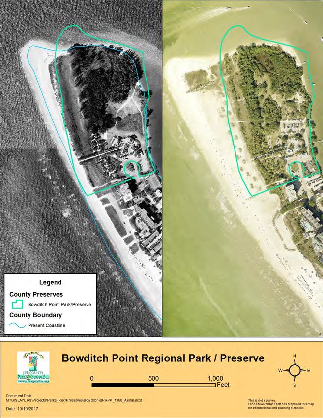
24Figure 9. 1968 Aerial Compared with 2016 Aerial
25Figure 10. 1998 Aerial Compared with 2016 Aerial
26iii. Public Interest
Residents and visitors have used Bowditch Point Preserve for walking, shelling,
sunbathing, swimming, fishing, and enjoying the sunset for many years. With the
acquisition of the site by Lee County in 1987, these activities are guaranteed to remain a
part of life on Fort Myers Beach.
The acquisition of this site was not without controversy. With the purchase option to
expire on December 31, 1987, the funding for this site was not in place when the purchase
was made. The Lee County Board of County Commissioners (BOCC) voted to purchase
the property on December 15, 1987, preventing the property from becoming a 155-unit
condominium development. To facilitate closing on the property by the deadline, the
BOCC increased the capital budget in proposed bond revenues. The Board initially
acquired Bowditch Point on December 22, 1987, by providing itself a short-term loan. In
July 1988, ad valorem funds were used in place of the short-term loan. In February 1989,
Bowditch Point was used as security for a bond issue.
A public planning meeting was held at Bay Oaks Community Center in July 1988 co-
sponsored by Lee County Parks and Recreation and the Southwest Florida chapter of the
American Society of Landscape Architects. For those in attendance the first order of
business was to visit the point and to not limit ideas.
Parking and a desire to not develop the point commercially were topics of the workshop.
Also supported was the retaining as much of the natural flavor as possible. A charter
committee was formed to review a conceptual master plan that would be presented to the
Board of County Commissioners August 17, 1988.
On May 31, 1989, the Board of County Commissioners approved the Professional
services agreement with Herbert/Halback Inc. for the master planning through
construction contract and public workshops were held at Bay Oaks Community Center in
November 1989. On May 16, 1990, the Board approved a Supplemental Agreement that
authorized detailed design of the park and its facilities.
Public and private school groups as well as private, government, and non-profit
organizations use Bowditch Point Preserve as an outdoor classroom. Coastal
geomorphology and ecology are effectively taught in this rare 17.9-acre area of beach
dune, coastal grassland, coastal strand, and mangrove swamp on Estero Island.
With improved parking areas, an amphitheater, and rest rooms, Bowditch Point Preserve
is a favorite beach stop for residents and visitors.
Information concerning this preserve and other Lee County managed conservation lands
can be found on the website www.leegov.com/conservation2020.
27V. Factors Influencing Management
A. Natural Trends and Disturbances
Natural trends influencing stewardship include hurricanes, drought, tropical storms, tidal
flooding, and patterns of wet and dry seasons, freezes, bird migration and nesting
seasons. Coastal grassland communities depend on occasional saltwater flooding to
keep from transforming into a coastal strand community (FNAI 2010). High-intensity wind
and long durations of standing salt water from tidal flooding or storm surge affects even
salt-tolerant plant species by weakening or eventually killing them (Appendix F). Bird
nesting and migration will be considered when events are planned or exotic pest plant
control work is scheduled in the Preserve, to minimize disturbance to birds foraging,
resting, feeding, and raising young.
Significant storms including Hurricane Charley in 2004 and Hurricane Irma in 2017 can
and have caused damage to the vegetation in the Preserve with mortality and dieback of
Jamaica dogwood, buttonwood, and sea grapes. If restoration needs to take place after
a significant storm, plant community and site elevation will be taken into consideration.
After flooding, low-lying areas of the Preserve are prone to hold salt water for a period of
time. It is not unusual to have a storm tide wash over or high tide inundated the coastal
areas of Bowditch Point Preserve and no precautions other than the removal of hazard
trees needs to be taken.
B. Internal Influences
There are varieties of internal influences that affect Bowditch Point Preserve.
Inappropriate public use, marine debris, visitor litter, and exotic pest plants. Use of the
area was limited to pedestrians and boaters before Lee County acquired the site. The
site was also used to deposit dredge spoil materials from the Matanzas Pass dredging
project of 1970. Due to the disturbed area of the Preserve, exotic pest plants invaded the
site. Control of exotic pest plants continues today along with constant debris
maintenance, which is related to the use of passing boaters and visitors to the site. When
applying any herbicide for invasive exotic plant removal, conservation land staff will follow
the procedures described in the Land Stewardship Operations Manual. Once purchased
and opened the Preserve was available to pedestrians, boaters, and individuals who
obtained parking passes for the few original parking spaces. Lee County Parks and
Recreation staff began the long process of exotic pest plant control. With the development
of the beach-side boardwalk, deck, restrooms, and additional parking, a more diverse
group of the public can enjoy this site. Visitors and residents require constant education
and updating on the rules for the Lee County Park system. Confusion exists due to the
contiguous beaches having differing rules regarding pets. The Town of Fort Myers Beach
28allows leashed pets to walk on the beach, where Lee County Parks and Recreation allows
dogs only at designated sites.
Conservation land staff has organized regular trash clean ups and has collaborated with
volunteers, school groups, and Keep Lee County Beautiful Inc. to decrease litter.
An active boating community uses the shoreline of the Preserve and boating channel
adjacent to the Preserve. Continual clean up of debris that washes up on the shore,
including containers of cleaning solutions, oil, and paint collected before the pollutants
leak into the waters will improve water quality.
Fishing is allowed in the Preserve, which could lead to problems with monofilament line
litter. Monofilament line can cause injury and death to birds and other wildlife when
tangled or ingested. Coordination with the Monofilament Recovery and Recycling
Program (http://fishinglinerecycling.org/) to organize volunteer clean-up days and setting
up recycling bins will help alleviate this problem.
Natural internal influences are the native plants and wildlife that need to be taken into
consideration when any exotic plant or animal control will be exercised. A map of the
gopher tortoise area is below and shows the area that is monitored where great care will
be taken (Figure 11).
Visits by the Lee County Park Rangers, Lee County Maintenance staff, Lee County Parks
and Recreation staff, and the Lee County Sheriff’s Office, has improved the behavior of
visitors in the Park.
C. External Influences
Bowditch Point Regional Park has two land-side neighbors, to the southwest is Pink Shell
Vacation Villas consisting of individually owned condominiums, and to the southeast are
the tennis courts and storage area of the Boykin Hotel Properties LP.
Concerns with the neighbors are beach rules conflicting with park rules (previously
explained) and the policy of red drift algae raking. Private property owners may rake the
beach in front of their property but not onto county owned-land. This situation will be
monitored and if necessary, the use of signage and presentations/public workshops
incorporating “When Nature is your Neighbor” and “Florida Yards and Neighborhoods”
will be used to alleviate any problems.
The majority of the Preserve is surrounded by the Gulf of Mexico, San Carlos Bay and
Matanzas Pass (Figure 12). Increased boating activity will likely occur as the population
of Lee County continues to increase. Presently, one out of ten Lee County residents owns
a power boat. With this comes the added problem of marine debris. Education and Keep
Lee County Beautiful Inc., and school groups, will help control this problem.
29Figure 11. Internal Influences Map
30Figure 12. External Influences Map
31D. Legal Obligations and Constraints
i. Permitting
Lee County’s Local Mitigation Strategy supports the efforts of the county to purchase
environmentally sensitive areas in High Hazard Flood Zones (Storm Surge-Coastal;
Appendix F). It also supports natural resource protection activities that preserve or
maintain natural areas through restoration and nourishment. The management of BPP
implements this strategy. If construction were to be considered in the Preserve, required
permits would need to be obtained from various agencies.
ii. Other Legal Constraints
The 1996 Florida Statutes Mangrove Trimming and Preservation Act (Sections 403.9321
- 403.9333) applies to all mangrove cutting and trimming and will be followed when
trimming trails in the wet primitive areas.
iii. Relationship to Other Plans
The Lee Plan is designed to depict Lee County, as it will appear in the year 2030. Given
the projected increase in population (to 979,000 permanent residents with additional 18%
seasonal residents) and the probable rate of technological change between the present
date and 2030, it is impossible to describe the future face of the County with any degree
of certainty or precision. However, the following list of themes will be of great importance
as Lee County approaches the planning horizon:
• The growth patterns of the County will continue to be dictated by a Future Land
Use (FLU) map that will not change dramatically during the time frame of this plan.
With the exception of Cape Coral and Lehigh Acres, the County's urban areas will
be essentially built out by 2030 (pending in some cases, redevelopment). The
County will attempt to maintain the clear distinction between urban and rural areas
that characterizes this plan. Its success will depend on two things: the continuing
viability of agricultural uses and the amount of publicly owned land in outlying
areas.
• The County will protect its natural resource base in order to maintain a high quality
of life for its residents and visitors. This will be accomplished through an aggressive
public land acquisition program and by maintaining and enforcing cost-effective
land use and environmental regulations that supplement federal, state and regional
regulatory programs.
• The County's traditional economic base will be diversified in order to increase the
percentage of high-paying jobs, reduce tax burdens on residents and enhance the
stability of the community. Traditional industries, such as agriculture, commercial
32You can also read