Claireville Conservation Area Public Use Activation Plan - February, 2021
←
→
Page content transcription
If your browser does not render page correctly, please read the page content below
Claireville Conservation Area
 Public Use Activation Plan
 February, 2021
CCA Activation Plan - Feb 9 2021.docx

TABLE OF CONTENTS
Section 1. Project Purpose and Justification....................................................................................................................... 1
 1.1 Project Goals.....................................................................................................................................................2
 1.2 Background .......................................................................................................................................................2
 1.3 Business Objectives ..........................................................................................................................................3
Section 2. Conservation Area Description .......................................................................................................................... 3
 2.1 Location and Site Features ...............................................................................................................................3
 2.2 Current and Historic Management Plans and Implementation Plans ..............................................................4
 2.3 Land Uses ..........................................................................................................................................................5
 2.4 Surrounding Community Needs and Interests .................................................................................................5
 2.4.1 Demographics ............................................................................................................................................5
 2.4.2 Needs and Interests of Surrounding Community ......................................................................................6
Section 3. Existing and Historical Programming, Physical Assets and Partnerships ........................................................... 7
 3.1 Physical assets ..................................................................................................................................................7
 3.1.1 Land and Asset Management ....................................................................................................................7
 3.1.2 Trails ..........................................................................................................................................................8
 3.1.3 Recreational Facilities and Infrastructure .................................................................................................8
 3.1.4 Restoration ............................................................................................................................................. 10
 3.1.5 Flood Risk Management ......................................................................................................................... 11
 3.2 TRCA Outreach, Engagement, and Education Programs ............................................................................... 11
 3.3 Previous and proposed uses and partnerships ............................................................................................. 12
 3.4 External programming, events, activities and agreements ........................................................................... 15
 3.4.1 Tenant Initiatives .................................................................................................................................... 15
 3.4.2 External Partnerships ............................................................................................................................. 16
Section 4. Investigation of Current Uses, Needs, and Opportunities ............................................................................... 17
 4.1 Research Questions ....................................................................................................................................... 17
 4.2 Method One: Semi-structured Interviews/Meetings .................................................................................... 17
 4.3 Results One: Semi-structured Interviews/Meetings ..................................................................................... 18
 4.4 Method Two: Survey ..................................................................................................................................... 20
 4.4.1 Delivery Method ..................................................................................................................................... 20
 4.5 Results Two: Survey ....................................................................................................................................... 21
 4.6 Method Three: Google Analytics ................................................................................................................... 28

 Toronto and Region Conservation Authority | i

CCA Activation Plan - Feb 9 2021.docx

 4.6.1 Online Reviews ....................................................................................................................................... 28
 4.6.2 Analysis ................................................................................................................................................... 29
Section 5. Recommendations ........................................................................................................................................... 30
Section 6. Conclusion ........................................................................................................................................................ 38
Appendix 1: Survey Instruments and Additional Information on Survey Goals .............................................................. 39
Appendix 2: Charts and Tables ......................................................................................................................................... 41
Appendix 3: Google Reviews ............................................................................................................................................ 50

 The information contained in this document is copyright
 © Toronto and Region Conservation Authority

 Toronto and Region Conservation Authority | ii

CCA Activation Plan - Feb 9 2021.docx SECTION 1. PROJECT PURPOSE AND JUSTIFICATION Claireville Conservation Area (“Claireville”) is a unique, valuable and desirable greenspace located within a highly urbanized setting. This 848-hectare park is located primarily in the City of Brampton, with a small portion (19 hectares) falling within the City of Toronto, and with both City of Mississauga and City of Vaughan immediately adjacent. Claireville is currently operating under a passive operating model, without regular staff, gate admissions, and supporting comfort services. Despite that “passive” model, the park offers a multitude of recreational opportunities and attracts both regular and intermittent users. In the past, Claireville was predominantly agricultural land, with limited development nearby. In recent decades however, significant industrial, commercial and residential development has occurred around Claireville, increasing the potential for public use of the site, as well as the importance of offering and properly utilizing a large greenspace in an urban area. Public interest has spurred Toronto and Region Conservation Authority (“TRCA”) efforts to explore how Claireville can be activated to better support the needs and desires of the community and current and potential users of Claireville, as well as fulfill TRCA’s mandate. As a result, TRCA has developed the Claireville Public Use Activation Plan (“Activation Plan”) to lay out the groundwork for activating Claireville. These efforts align with TRCA’s Building The Living City - Our 10-year Strategic Plan through the following: As TRCA develops and carries out creative and innovative approaches to maximize the value of TRCA lands and greenspace, the desire exists to make more of Claireville a safe and welcoming greenspace accessible to the surrounding population and other visitors (item 3.1); Claireville’s urban location offers the opportunity to introduce community members to TRCA lands, initiatives and values, as well as create opportunities to invest in, and update, existing onsite infrastructure (items 4.2, and 5.1);
CCA Activation Plan - Feb 9 2021.docx New and increased programming and infrastructure at Claireville could open the site to new business models with complementary partners and the community (items 7.1 and 7.3); These partnerships can ensure efficiencies in project/program delivery, as well as offer innovative programming that fits the needs of visitors and creates value and opportunities for the surrounding community (item 5.3, 6.1, and 6.3) 1.1 Project Goals The intent of the Claireville Activation Plan is to increase and enhance public engagement and business opportunities surrounding Claireville, while building upon the existing Claireville Conservation Area Management Plan Update (2012) and respecting Claireville’s current focus on ecological restoration and passive recreation. The Claireville Activation Plan will lay the groundwork to fulfill the following goals: Activate Claireville Conservation Area through improved public perception and use of the site; Improve the public’s connection to, and use of, Claireville through new and existing partnerships and programs; and Align the activation of Claireville with TRCA’s strategic priorities and the existing Claireville Conservation Area Management Plan The term “activation” can be interpreted in multiple ways. To achieve activation, the recommendations in this plan seek to achieve that: Visitors feel that Claireville is an open, safe and welcoming site. The care that TRCA and relevant partners have for Claireville is evident, as is their efforts to both make the public comfortable and protect ecological values. The surrounding community becomes “active owners” of Claireville. This means that the community feels a sense of ownership of, and responsibility for, Claireville and is engaged in its care, management and programming. Existing and new programming is offered at Claireville. Programming fits the needs and desires of the local community and other visitors. Programming offered at Claireville aligns with TRCA’s values and priorities. Programming, services and infrastructure can be offered by TRCA and/or other partners. Collaborating with partners should result in some, or all, of the following: innovative partnership structures; efficiency of resources; more appropriate or interesting programming and events; reduced burden on TRCA staff time and resources; and economic, cultural, social or environmental benefits to the community and surrounding neighbourhood. Appropriate facilities are available that complement the passive use focus of Claireville, while supporting visitors and programming It is acknowledged that activation involves both short- and long-term goals and actions The Claireville Activation Plan will provide a ready foundation from which TRCA, partners and the community can begin implementing short- and long-term goals to activate Claireville and create a safe, open environment for visitors. 1.2 Background TRCA staff completed the Claireville Conservation Area Management Plan Update (“Management Plan Update”) in 2012, which lays out the most recent overarching priorities and direction for the management of Claireville. The Management Plan Update includes an emphasis on ecological restoration of the site and passive use. TRCA then endorsed the Claireville Conservation Area Land Management Implementation Plan (‘the Implementation Plan”) in
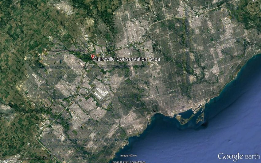
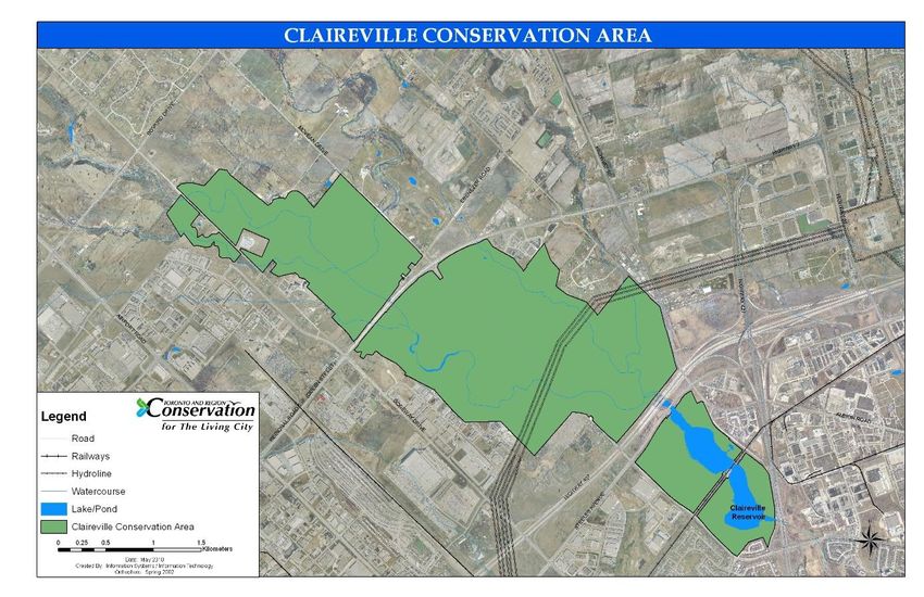
CCA Activation Plan - Feb 9 2021.docx 2015 to further direct priority implementation projects. The Activation Plan is intended to align with the direction and priorities laid out in the Management Plan Update and the Implementation Plan. Several efforts have been made to activate Claireville in the past. In 1996 TRCA’s Board of Directors, hosted a Claireville Technical Advisory Committee, which examined potential initiatives for Claireville and the development of a management plan for the conservation area. The former Humber Watershed Alliance, a multi-stakeholder advisory group was instrumental in working with TRCA and partners to implement the Humber Watershed Management Plan - Legacy: A Strategy for a Healthy Humber. In 2007, TRCA staff was directed to work with approximately 60 other interested agencies and organizations in the Claireville Leadership Adventure Conservation (CLAC) Partnership to explore programming partnerships. However, these efforts did not result in the desired activation of the site (a more detailed outline of previous activities and programs in Claireville can be found in Section 3 - Existing and Historical Programs, Physical Assets, and Partnerships). In September 2018, a delegation was made to the Regional Watershed Alliance (RWA Meeting #3/18) to request that TRCA staff and RWA members explore the activation of Claireville. 1.3 Business Objectives The corporate direction of TRCA is guided by Building The Living City - Our 10-year Strategic Plan that establishes the framework for our programs. It provides twelve enabling and leadership strategies towards achieving our corporate vision of The Living City. The reactivation of Claireville ties into the strategies and associated commitments including: Achieving the most appropriate use of TRCA’s inventory of lands and facilities while respecting natural and cultural heritage; Investing in aging infrastructure across TRCA’s Conservation Areas; Restoring and providing more accessible greenspace; Offering open space opportunities as part of complete communities that benefit community members; More frequent engagement by community members in nature-based educational and recreational activities; Strong community leadership in, and ownership of, sustainability initiatives; and Reflection of the diversity of the Toronto region in TRCA programs. SECTION 2. CONSERVATION AREA DESCRIPTION 2.1 Location and Site Features Claireville Conservation Area is an 848-hectare (2100 acre) parcel of TRCA-owned land situated in the Humber River Watershed, where Salt Creek converges into the West Humber River. The land was secured in the 1950s. Included in this parcel is the Claireville Reservoir, Indian Line Campground, Wet’n Wild Water Park, a 98-hectare parcel of land formally known as the “Ebenezer Resource Management Tract” (located north of Regional Road 107 and bounded by McVean Drive and Goreway Drive to the east and west respectively), and the formal conservation area between Steeles Avenue and Peel Regional Road 107 (Queen St). The majority of Claireville is in Peel Region within the City of Brampton, with a small portion (19 Ha) within the City of Toronto. Both the City of Vaughan (York Region) and Mississauga (Region of Peel) are immediately adjacent to the conservation area.
CCA Activation Plan - Feb 9 2021.docx

FIGURE 1: CLAIREVILLE CONSERVATION AREA MAP (MANAGEMENT PLAN UPDATE 2012)

2.2 Current and Historic Management Plans and Implementation Plans
Over the better part of the 20th century until present day, several management plans, project proposals, and
strategies have been put into place to guide the management of the site. Previously, Claireville was identified as one
of the most important destinations in the Greater Toronto Area for recreation and interpretive activities in the 1964
Claireville Master Plan, the 1980 MTRCA Watershed Plan, the 1989 MTRCA Greenspace Strategy for the Greater
Toronto Area, and the 1996 Humber Watershed Strategy. The previous management plan (1997) was updated in
2012. This management plan still recognizes the important recreation opportunities offered by the conservation area
and provides guidance for park management under an ecosystem approach that prioritizes ecological enhancement
and preservation.
The management plan divides the conservation area into nine management zones. The division of these zones
prioritizes habitat: 82% of the property is designated in one of three related categories: Nature Reserve, Natural
Environment, or Primary Restoration. Recommendations focus on maintaining and improving the natural ecosystem
health of the conservation area and continuing low to moderate public use. This focus, however, does not preclude
new partnerships and public engagement opportunities but does provide scope for acceptable use.
CCA Activation Plan - Feb 9 2021.docx

 Vision Statement of Current Claireville Management Plan (updated 2012)

 Claireville Conservation Area is an oasis for wildlife and people—a healthy, diverse urban forest and one of the
 largest natural corridors in a major city region. It is a destination where the natural and cultural heritage
 resources are protected and restored through partnerships and community-based stewardship. Visitors enjoy
 year-round nature-based recreation and education experiences while respecting the unique environmental
 features.

 -2012 Management Plan Update

2.3 Land Uses
The Humber River was designated a Canadian Heritage River due to its significant cultural history. While the West
Humber River tributary was not formally recognized as part of this designation, there is still significant cultural history
to be found in this area. Prior to European settlement, the Humber River was used as a route connecting Lake Ontario
to the Lake Simcoe watershed and beyond. This route, known as the Carrying Place Trail, became a key route for
trade between Indigenous groups, and later with European settlers. After European settlement, the land was used for
agriculture. Since the acquisition of the property in the 1950s, TRCA has been working to restore the forest and
meadow habitats that existed pre-contact.
In addition to restoration work, various public initiatives are offered at the site (see Section 3). Furthermore,
Claireville currently hosts an urban farm, a horseback riding ranch, and a waterpark. Movie shoots frequently take
place at the site and the park is utilized by trail users, dog walkers, and other members of the public. Claireville is also
home to the historic Wiley bowstring bridge, the historic McVean Barn, and a dam and reservoir, all of which require
restoration and improvements. The portion of Claireville north of Highway 407 and Steeles Ave is currently operating
as a conservation greenspace and as such, facilities and services are limited.

2.4 Surrounding Community Needs and Interests
The following section provides an overview of the demographics of the area surrounding Claireville.

2.4.1 Demographics
The City of Brampton is one of the fastest growing communities in the GTA; since 2011, Brampton’s population has
increased by 13.3%.1 It is also home to a relatively young population - the average age is 36.5 years (compared to
Ontario’s mean age of 41), with ages 0-14 comprising 20% of the population, ages 15-54 comprising 57% of the
population and over 55 comprising 22% of the population.2
In 2019, Environics data was compiled for the postal codes immediately surrounding the conservation area. Within
that area there are 965,098 individuals and 274,374 households. The average household income is $111,884 with

1
 City of Brampton. 2019. Population & Dwelling. Accessed from: https://geohub.brampton.ca/pages/profile-
pop-dwelling
2
 City of Brampton. 2019. Age & Sex. Accessed from: https://geohub.brampton.ca/pages/profile-age-sex
CCA Activation Plan - Feb 9 2021.docx

74.4% of residents residing in detached houses. Cars are the main mode of transportation, with only 15% of residents
citing they use public transit to go to work. The region is also home to a substantial portion of new Canadians, with
54% of the population identifying as immigrants, 5% citing no knowledge of English, and 73% belonging to a visible
minority group (of that group, 42% are South Asian).

2.4.2 Needs and Interests of Surrounding Community
Table 1 represents the self-reported interest in a variety of activities among residents surrounding Claireville collected
through Environics. A large proportion are interested in activities that are directly relevant to Claireville such as
jogging and walking. This demographic data suggests that there are increasing needs in the surrounding community
for programs and facilities that are diverse in language and culture, and that target growing families. There is an
interest in outdoor activities (as suggested by the reporting in leisure and sport activities, Table 1) and as the
community continues to grow, the demand for outdoor green space will increase. Claireville represents an
opportunity to meet those needs.
Further needs and interests of the surrounding community were assessed via a survey (2019), the results of which are
discussed in Section 4.
TABLE 1: LOCAL COMMUNITY INTERESTS FROM ENVIRONICS DATA (2019)
 Activity Category Activity Proportion of Interested
 Population
 Local Attractions & Theme Parks 28.2%
 Destinations
 Indoor Amusement Centres 11.5%
 Zoo/Aquarium 28.2%
 Dancing/Night Club 8.5%
 Professional Sports Basketball 14.6%
 Hockey 21.4%
 Baseball 29.0%
 Soccer 9.7%
 Concert & Theatre Venues Casinos 13.2%
 Areas 33.7%
 Outdoor Stages 9.0%
 Theatre Other 7.2%
 Individual Sports Snowboarding 7.5%
 Billiards/Pool 31.1%
 Inline Skating 6.4%
 Racquet Sports 15.8%
 Team Sports Football 9.6%
 Soccer 19.3%
CCA Activation Plan - Feb 9 2021.docx Basketball 19.7% Baseball/Softball 19.3% Activities Ice Skating 33.5% Power Boating/Jet Skiing 10.0% Fishing/Hunting 23.3% Art/Crafts 40.2% Fitness Jogging 33.5% Home Exercise 60.1% Fitness Classes 33.1% Fitness Walking 49.1% SECTION 3. EXISTING AND HISTORICAL PROGRAMMING, PHYSICAL ASSETS AND PARTNERSHIPS 3.1 Physical assets There are numerous physical assets in Claireville, from habitat restoration sites to tenant properties, to recreational facilities. The following section provides an overview of all those assets and a summary of TRCA-led management of those assets from 2011 until 2019. 3.1.1 Land and Asset Management Table 2 summarizes the work completed between 2011 and 2019 to manage the conservation area and tenant properties. TABLE 2: LAND AND ASSET MANAGEMENT WORKS Project/Initiative Projects implemented 2011-2019 Site securement and Identified and removed encroachments throughout property protection Installed 1030 metres of fence and 2 gates Installed entrance gate from Gorewood Drive Prepared for land inventory and audit report Blocked vehicle access from Gorewood Drive Installed a kiosk at Queen Street and Gorewood Drive parking lots Removed garbage and repaired fencing Developed parking area at the Regional Road 107 (Queen Street) trail head Land management Constructed installed 49 post markers for wayfinding through property Removed 192 hazardous trees along trails to eliminate hazards on existing authorized trail system Prepared structural assessment report for the Claireville Barn
CCA Activation Plan - Feb 9 2021.docx Completed initial rehabilitation of the McVean Barn with the construction of a water diversion channel and securement of the structure Decommissioned three old wells Constructed the trail head parking lot at Regional Road 107 access Reconditioned, compacted, and filled Gorewood and Highway 50 parking lot Repaired post and paddle fencing at Highway 50 parking lot Removed structures at Claireville Ranch and portable classroom, and carried out site restoration and re-naturalization Manure storage facility constructed Removed almost 9500 kilograms of debris McVean Farm Continued use of the farm site as an incubator farm. In 2011 a 110-acre parcel located at Ebenezer and McVean was added to accommodate more farm participants. Completed barn improvements and securement, including downspout and siding repairs Robinson house In 2017 the former Robinson House was leased under a commercial lease agreement. 3.1.2 Trails There is a broad network of trails throughout the Claireville property. These trails include an interregional trail that connects Brampton trails into the City of Toronto, and secondary trails throughout the formal conservation area. Work on these trails is summarized in Table 3. TABLE 3: TRAIL WORKS Project/Initiative Projects implemented 2011-2019 Interregional Trail Ongoing work to link trails between the City of Toronto and City of Brampton Secondary trails Prepared secondary trail plan Completed visitor monitoring and survey through online and in-person trail user surveys and an electronic trail counter program Inventoried 50 kilometres of trails Built 3.1 kilometres of trails and 360 metres of boardwalk Installed 2 trail head kiosks and signs Installed secondary wayfinding system at trail junctions. Upgraded 8.5 kilometres of trail to an amended surface trail (natural parent soil mixed with gravel to make a better trail surface) 3.1.3 Recreational Facilities and Infrastructure There are two public use areas actively managed by TRCA: the formal conservation area, and Indian Line Campground. The management plan prioritizes passive use by the public for the conservation area portion of the site. Table 4 summarizes the work, including infrastructure-related projects, complete to date for these two facilities.
CCA Activation Plan - Feb 9 2021.docx TABLE 4: RECREATIONAL AREAS MAINTENANCE WORKS Project/Initiative Projects implemented 2011-2019 Claireville Conservation Improved City of Toronto and City of Brampton day camp sites Area (Central Area Regraded and compacted 1.1 kilometres of road between Hwy 50 Installed new property sign at Regional Road 107 entrance entrance and Hwy Completed erosion control work on the roadway adjacent to Humber 7/Queen entrance) River Installed 1 culvert Undertook ongoing risk management mitigation Completed property promotion/marketing for filming purposes (Ontario Media Development Corporation OMDC website) Armour stone placement in and around Highway 50 parking lot to prevent vehicular access. Boulder placement behind Gorewood entrance gate to prevent vehicular access. Hazard tree removal and Ash tree removal. Information kiosks at the Highway 50 and Gorewood entrances Water line repairs throughout. Installed new property sign at Highway 50. Indian Line Campground Carried out Crime Prevention Through Environmental Design (CPTED) (est. 1973) Security Audit through Peel Region Police Seeded 120 square metres Installed 70 directional and campground signs Retrofitted two buildings to improve accessibility, and installed energy efficient showers, sinks, washrooms and doorways Installed 1700 square feet of metal roof at pool building Improved 530 square metres of road Replaced 20 building mounted and 25 streetlights, using LED and photocells Installed 8 roof mounted solar panels Installed 30 metre drainage naturalization project New entrance gates to the facility. 2020 New access gates to the work yard. 2020 12 new metal doors for the 3 washroom buildings. The ramp to the camp store was replaced and was made to be accessible. Waterproofing of the pool building foundation. Replaced the existing concrete walkway on north side of the pool building and replaced a portion of the concrete pool deck after the waterproofing. Added a section of concrete walkway to the east side of the pool building. Replaced the concrete walkway around the campground office. Replaced the pool liner. Replaced 8 washers and 8 driers in our laundry facility. Replaced the transformers in the campground. Including the breaker panels in the 3 washroom buildings.
CCA Activation Plan - Feb 9 2021.docx Replaced the woodchips in the playground. Replaced the windows and doors in the campground office. Installed a heat pump in the camp store. Replaced the windows in the camp store. Replaced the hot water tank in the office and Humber washroom. Installed an outer cladding to the Humber and Poplar washroom buildings. Replaced the ventilation fan units on the Humber and Poplar washroom buildings. Installation of 6 security cameras, 1 in the office, 4 in the and around the camp store and 1 at the Dump Station. 3.1.4 Restoration Restoration and management of Claireville’s natural habitats, including forests, streams, wetlands, meadows as well as targeted fish and wildlife habitat has been an ongoing priority. Table 5 provides a summary of restoration activities carried out between 2011 and 2019. TABLE 5: RESTORATION WORKS Project/Initiative Projects implemented 2011-2019 Ecological Restoration Over 100 000 trees and shrubs planted and Management 45 hectares of forest habitat restored 9 hectares of wetland habitat created or restored 2919 metres and 7 hectares of riparian habitat restored 9 hectares of meadow habitat restored 1109 metres of stream restoration 1 aquatic barrier mitigated 9 hectares of forest management thinning 125 hectares of forest management inventory Strategic invasive species management West Claireville buffer Completed topsoil placement project berm Phased reforestation of the berm (Hwy 50 Entrance) Community-Based Multiple community events are held throughout the year with the Restoration Events general public, schools, and corporate groups. These events include native tree and shrub plantings, invasive species management activities, litter clean-ups, and monitoring and maintaining restoration sites. Between 2011 and 2019 over 40 events have been held that engaged over 2100 participants who planted more than 4500 native trees and shrubs. Earth Day planting events co-hosted with City of Brampton Hwy 50 Meadow Planting with members of the Regional Watershed Alliance Litter clean up events with the general public and local schools
CCA Activation Plan - Feb 9 2021.docx 3.1.5 Flood Risk Management Maintenance of the Claireville Dam is an ongoing priority for TRCA. A Dam Safety Review of Claireville Dam was carried out in 2016 and identified the need for several improvements, including designing and rebuilding the spillway to pass extreme events, enlarging the spillway to prevent erosion, repairing the dam wingwall, rebuilding the gate system and undertaking corrosion repair work. TABLE 6: FLOOD INFRASTRUCTURE WORKS Project/Initiative Projects and programs implemented 2011-2019 Dam Safety/Flood Risk Completed Dam Safety Review at Claireville Dam (2016). Management Following a significant storm on July 13th 2013, the reservoir was drawn down to a lower level to accommodate the increased precipitation. In the fall of 2013, the decision was made to keep the reservoir at the lower level to maximize flood storage at the dam. This decision, made for safety reasons, means that the historic “recreational” water level of the dam can no longer be safely maintained without significant and costly work done to the dam structure. 3.2 TRCA Outreach, Engagement, and Education Programs Claireville has always been an important site for recreation and engagement for both TRCA and the surrounding community. Table 7 provides a list of the current activities and programs that occur in the conservation area. TABLE 7: OUTREACH EDUCATION AND COMMUNITY RESTORATION PROGRAMS Project/Initiative Projects and programs implemented 2011-2019 Seasonal Nature Hikes Multiple events are scheduled throughout the year, from guided walks, to interpretive education programs, and community planting events. TreeCaching Trail program, a smartphone-based tree identification self-guided walk Snowshoes and Snow-Clues, a program for the general public to learn how to snowshoe and about animal tracks and adaptations Hoot and Howl, a program for the general public to learn about owls and coyotes. Activities include interactive games and an evening walk calling for these animals. Park in the Dark hike, an evening walk learning about nocturnal animals with fun activities. Farm tours of the McVean Farm for the general public to learn about the McVean Farm and the importance of local food and urban agriculture Youth Opportunities Conservation Youth Corp program assists with trail restoration and phragmites removal Nikibii Dawadinna Giligwag, the Indigenous youth program, helped invasive species mapping
CCA Activation Plan - Feb 9 2021.docx Peel Planet Day, a stewardship and education event for 250 Region of Peel high school student Drop-in programs for participants at Camp Claireville Educational Events Crawling Crayfish, a program for the general public to collect the benthic invertebrates, learn what makes a healthy watershed and our connection with them. Citizen Science Initiatives Frog Watch, a program for the public to learn about how to identify frogs by their unique calls. Observations are submitted to Frog Watch App. All About Bats, a program for the general public to learn how these creatures navigate at night and listen for some flying above using a bat detector. That data is then shared with TRCA’s monitoring team. Farm Events Farm operators have hosted farm open houses and fundraisers for the farm during the farm season. 3.3 Previous and proposed uses and partnerships Over the years there have been a multitude of attempted and successful partnerships between TRCA and different groups to undertake programming in Claireville. These different initiatives utilized partnerships between TRCA, the community, and other municipalities/agencies/organizations. Not all proposals that were brought forward (both by TRCA and by external groups) were implemented. Of those that were initiated, partnerships and initiatives linked to existing funding, whether through a granting body, or the securement of capital funds, were the most successful. Claireville Subcommittee West Humber Subcommittee (i.e., Claireville Subcommittee) of the Humber Watershed Alliance (a former TRCA citizen advisory group) was established to focus on assisting TRCA with implementing the watershed plan in the West Humber subwatershed. The Subcommittee was administered by TRCA and was comprised of members from: Architectural Conservancy of Ontario Elected officials from the Cities of Brampton, Mississauga, and Toronto Friends of Claireville Residents from Brampton, Caledon, Toronto and Vaughan West Humber Naturalists The Subcommittee reviewed the 1997 Management Plan and made the primary suggestions to remove the “Commercial Management Zone” on Regional Road 107 (Queen Street) and avoid trail impacts on interior forest habitat. The Claireville Subcommittee was dissolved along with the Humber Watershed Alliance in 2015 as TRCA embarked on developing a new citizen governance model as part of TRCA’s Community Engagement Strategy (2017). Friends of Claireville The Friends of Claireville (FOC) was a volunteer group formed in 1999, who sought to educate the public about environmental issues and to engage the community in environmental stewardship activities at Claireville Conservation Area. Joint initiatives included community plantings (over 20,000 trees planted to date), clean-ups,
CCA Activation Plan - Feb 9 2021.docx guided hikes and other community events for families, seniors, youth and new Canadians. The FOC was also an active group on the Humber Watershed Alliance. The Friends of Claireville dissolved following the completion of the Claireville Community Stewardship Project in 2008. Claireville Community Stewardship Project (CCSP) In 2006, TRCA was granted $100,500 in financial support from the Ontario Trillium Foundation (OTF) to support the Claireville Community Stewardship Project (CCSP). The goal of the CCSP was to strengthen the organizational structure and capacity of the Friends of Claireville and to foster awareness, build community and restore the ecological health of the Claireville Conservation Area. The project included hands-on environmental stewardship programs that provided youth, adults, community and business leaders with the knowledge and tools required to help revitalize and care for the watershed's natural resources. As of June 30th, 2008, all workplans associated with the CCSP were completed as outlined in the Ontario Trillium Foundation Proposal and Funding Agreement. Over the three-year project the CCSP: Organized and implemented 6 community planting events, planting over 3,500 native trees and shrubs. Delivered 14 habitat enhancement projects that included the installation of 75 songbird boxes, 8 Wood Duck nesting boxes, log fish cribs, removed invasive species and the planting of over 400 aquatic plants. Established tree monitoring plots to monitor tree health on newly and recently planted sites using established and accepted protocols. Delivered 8 community educational workshops /seminars. Organized and implemented 3 community shoreline clean -up events, removing over 2,500 Ibs of garbage. Developed and successfully launched the Claireville Stewards in the Field Program Developed communication and marketing materials for The CCSP and the Friends of Claireville including two displays, project Fact sheets, newsletters, event flyers, and portable signage. Organized and implemented a Fishing Festival at the Claireville Reservoir. Installed two Trailhead Kiosks at the Regional Road 107 and Highway 50 entrances Installed all- access fishing and canoe dock at the Claireville Reservoir Core funding for the CCSP was provided by Ontario Trillium Foundation (OTF) in the amount of $100,500. The project also received funding from the Region of Peel in the amount of $100,000. Additional funding for this project was provided by: Shell Environmental Fund ($4,500); Community Fisheries/Wildlife Involvement Program ($3,000); and In -kind support from community volunteers ($56,000) In total, the Claireville Community Stewardship Project raised over $264,000 and was completed in 2008. Claireville Leadership Adventure Conservation (CLAC) Partnership In 2005, a proposal was submitted to TRCA’s Business Excellence Advisory Board (RES.#C57/05) to create a Claireville Leadership Adventure Conservation (CLAC) Partnership. The idea was proposed by staff from the City of Toronto Parks, Forestry and Recreation Department as an opportunity for external groups to develop, operate and generally benefit from each other’s strengths and recreation programs at Claireville Conservation Area. The objective was to provide a coordinated approach amongst interested groups to use the site. It was envisioned that the partnership arrangement would facilitate the cooperative sharing of collective natural and recreational resources between the groups. Cost sharing of some common needs, such as toilets, parking and storage
CCA Activation Plan - Feb 9 2021.docx could also take place. This partnership would facilitate communication between the user groups to minimize conflicts and maximize opportunities for cross promotion. The values of the groups involved in the CLAC would include respect for other user groups and the environment. It was anticipated that spin-offs from this partnership could include potential community economic development opportunities, outreach to the surrounding new immigrant and low- income communities, and experiential learning opportunities for everyone. After a preliminary meeting with some interested groups and TRCA senior staff, it was decided that a larger meeting was necessary to determine who would be interested in joining a federation of partners to carry this concept forward. An initial meeting was held in August 2004 where 90 individuals from over 60 organizations, representing a wide variety of outdoor recreation organizations including canoeing, fishing, archery, orienteering, camping, municipal parks and recreation, scouts, and others, were invited. Twenty-one individuals, representing external recreation providers, attended this initial meeting. Six meetings were held in total between August 2004 and April 2005. A draft business plan and terms of reference was developed, which included timelines and possible recreational uses at Claireville by the partners. Funding and staff capacity to support the business plan was not secured, and as a result the Claireville Leadership Adventure Partnership was never fully developed. Yeoman Rugby Club The former Peachy residence is one of the historic cultural features of Claireville. For many years it was not used and fell into disrepair. In 1996, the Yeoman Rugby Club renovated the residence and used it as their club house. Rugby fields were constructed on 1.2 Ha of former agricultural fields. The lease and agreement have since ended. Chinguacousy (sometimes spelled “Chiquacousy”) Snowmobile Club A 2.8 Ha parcel of land in the north west part of the Ebeneezer Tract was leased to the Chinguacousy Snowmobile Club. The lease ended prior to the development of the management plan update in 2012. Historic Proposals and Documents for the CA There have been numerous management plans, master plans, and land-use proposals for Claireville over the years. The preceding section has outlined some of the most recent documents. Prior to the most recent management plan, the following plans and proposals were developed: 1964 Claireville Master Plan 1982 Claireville Master Plan 1984 Water Park Master Plan 1985 Golf Course proposal (submitted to TRCA, was not implemented) 1988 Greenspace Concept Development Plan 1989 Golf Course proposal (submitted to TRCA, was not implemented) 1990 Master Planning Study 1990 Olympic Equestrian Centre Proposal (submitted by Horse Park Corporation, was not implemented) 1994 Claireville Trail Project 1996 Ontario Golf Association Course Proposal (submitted to TRCA, was not implemented) 1997 Claireville Conservation Area Management Plan 2007 Heritage Trail Proposal (submitted by Architectural Conservancy of Ontario, Brampton Branch) 2012 Management Plan Update
CCA Activation Plan - Feb 9 2021.docx

3.4 External programming, events, activities and agreements
In addition to the programs offered by TRCA, there are several partner-led initiatives held in Claireville.

3.4.1 Tenant Initiatives
Agricultural Properties
McVean Farm is Brampton’s oldest farm and was once owned by early settler Alexander McVean. The double English
Wheat Barn that McVean and his family built there in the 1840s still stands today and is designated a “Category A”
heritage resource by the City of Brampton.
The McVean Incubator Farm began in 2008 as a pilot urban agriculture project with FarmStart as the operator. The
historic McVean Farm site was leased to FarmStart from 2008 to 2016 to train and support new farmers. In 2017,
TRCA took over operation of the farm site and administered individual lease agreements with participants of the
Incubator Farm. In 2020 TRCA transitioned to a new farm operator who is responsible for operating the McVean
Incubator Farm.
McVean Incubator Farm participants have access to land, shared infrastructure, water, and training opportunities.
This site and incubator model provide an opportunity for new farmers from non-farming backgrounds, new Canadians
and second career farmers to establish their farm enterprises. The site has capacity for up to 20 farm participants,
depending on the scale of their operation, background and expertise. These participants are operating small-scale
farm enterprises that provide local food to markets throughout the GTA.
TRCA is also in the process of developing an agreement with City of Brampton to provide land at McVean Farm for
community gardens, with the intention that the City of Brampton will begin operations of the community gardens in
2021.
Claireville Ranch
This small facility, operated by a private company, opened to the public in 1984. It offers private instruction and
public horseback riding through an extensive network of trails. The barn that existed on site before TRCA acquired the
property is included in the lease. As well, TRCA constructed a saddle house for use by the Ranch. The Ranch is leased
on an annual basis.
Residential Properties
Two residential properties continue to be leased to tenants.
Wet ‘n’ Wild (previously Wild Water Kingdom)
Wild Water Kingdom was built on 45 Ha of land adjacent to the former Claireville beach area, to the north of Indian
Line Campground. The facility, constructed by a private company, opened in 1989 under the name “Sunshine Beach”,
later adopting the name “Wild Water Kingdom” in the early 1990s. Construction of the water park initially cost
approximately $5 million. At the centre of the water park is a large wave pool, a lazy river ride and over seven water
slides. There is also a children’s water play area, waterfalls, ponds, hot tubs, showers, arcades, sports fields, miniature
golf, refreshments and gift shops, and a large picnic area.
Wild Water Kingdom closed in 2014 and re-opened under new management with the name “Wet ’n’ Wild” in 2017.
Etobicoke Field Centre
CCA Activation Plan - Feb 9 2021.docx

The original Education Centre used by the Toronto District School Board (TDSB) was located at the corner of Steeles
Avenue and Gorewood Drive but was demolished when Highway 407 was built. In 1992 the new facility was built by
TRCA using revenue generated through the sale of the Highway 407 land. The Field Centre is now located near the
Highway 50 entrance to Claireville. Historically, a low maintenance group camping area located to the north east of
the Education Centre was used by the Field Centre, but that site is no longer operational.
Until the 2019/2020 school year, the Field Centre ran programming for TDSB students throughout the school year,
servicing a variety of ages. In the past, they also ran a summer Eco Leadership Camp for students in grades 3, 4 and 5,
which incorporated ecological literacy into active outdoor learning to promote leadership and stewardship through
Global Competencies, and included a variety of hands-on activities in the natural environment. The Field Centre was
vacated by the TDSB for the 2019/2020 school year due to budget considerations. TRCA is currently exploring
alternative uses for this site and will issue an Expression of Interest in 2021 in an effort to facilitate future partnership
opportunities.

3.4.2 External Partnerships
Day Camps
The City of Toronto operates a summer day camp at Claireville. This camp includes activities for children aged 6 to 16,
with a range of programming including crafts, hiking, archery, French immersion, babysitting certification, sports,
drama, and horseback riding.
The Learning Enrichment Foundation extended their existing day camp program to include regular visits to Claireville
during the summer of 2019. This program targeted children and youth from the City of Toronto who have limited
opportunity to spend time outdoors.
In 2008 the City of Brampton explored a partnership with TRCA for a summer camp. The camp ran for two summers
but was deemed no longer feasible and the partnership ended.
Filming Location
Like several other TRCA sites, the conservation area is used extensively for film productions. This is the most
significant revenue generating activity in the park to date. Over recent years, eight to ten films or television shows per
year are filmed at Claireville. Timing, duration, number of film productions and associated busy times vary widely.
TRCA requires that filming locations are carefully selected so as not to permanently affect the site’s ecology. TRCA
also requires that production companies fully restore sites they use to pre-filming conditions. Furthermore, revenues
generated from filming is used to support the continued maintenance and enhancement of the park and TRCA’s work.
CCA Activation Plan - Feb 9 2021.docx SECTION 4. INVESTIGATION OF CURRENT USES, NEEDS, AND OPPORTUNITIES An investigation of current park uses, community needs, and both existing and future opportunities was undertaken to determine the most relevant recommendations for the Claireville Public Use Activation Plan. The following section summarizes this research process. 4.1 Research Questions The following research questions were used to develop the activation plan: 1. Are stakeholders familiar with Claireville? 2. What are stakeholder perceptions of Claireville? 3. What public demands exist regarding greenspace that Claireville could satisfy? 4. What opportunities exist at Claireville, or can be developed, to increase use of the site? 5. What priorities or uses do stakeholders value Claireville for? This research was carried out in two phases: (1) semi-structured interviews and meetings with key stakeholders; (2) utilizing the results of the consultation to develop and administer a quantitative survey to Claireville users and the surrounding community; and (3) conducting a review of online analytics and feedback associated with Claireville. 4.2 Method One: Semi-structured Interviews/Meetings Meetings were carried out over the Spring of 2019. These initial meetings introduced the Claireville Public Use Activation Plan concept and initiated a discussion around each of the four research questions. Specific themes were identified from the data collected. TABLE 8: STAKEHOLDERS INTERVIEWED Internal to TRCA External Stakeholders Community Stakeholders Property and Risk City of Brampton Boys and Girls Club of Management City of Toronto Peel
CCA Activation Plan - Feb 9 2021.docx Restoration and City of Vaughan Bramalea Network Infrastructure Peel Region Police Springdale Network Education and Peel Region Health Regional Watershed Training Region of Peel Alliance Planning and Planning Former CLAC Development members Parks and Culture 4.3 Results One: Semi-structured Interviews/Meetings Several common themes emerged from these discussions, which were categorized into four broad categories: Facilities, Infrastructure and Operations; Management Structure; Programming; and Market Analysis. Facilities Infrastructure and Operations Notable themes that emerged in this category include trails, accessibility, washrooms, parking, and safety. Specifically: There is desire among the groups consulted to improve public accessibility to Claireville, emphasizing the Inter-Regional Trail so that the different municipalities can be connected through active transportation routes. The opportunity for trail connections, including the opportunity to connect to the Riverstone Golf Course property, the sale of which is currently under negotiation with the City of Brampton. The issue of dogs off-leash was consistently brought up at every meeting, as well as the associated need for enforcement. Stakeholders have noted illegal activity taking place in the park. “More eyes” on the conservation areas are needed through increased community use, more active enforcement, and increased staff presence. Management Structure Themes that emerged in this category included tying programs and initiatives to policy, such as TRCA’s Strategic Plan and the City of Brampton’s 2040 Vision: Among municipal stakeholders there is a desire to tie the activation of Claireville to municipal goals, as this could also help to identify future funding opportunities. Among internal stakeholders, standard of care was discussed, as well as ensuring that activation was consistent with the existing Claireville Management Plan, and the 10-year Restoration Plan. Programs Existing and potential programs were discussed at all stakeholder meetings, with programming types and themes being identified according to three categories: General Programs; Programs Requiring Additional Infrastructure; and Revenue Generating Programs. General Programs Many of the discussions around programming praised the existing programs at Claireville, as well as the potential expansion of these programs. It should be noted that some of these programs could become
CCA Activation Plan - Feb 9 2021.docx revenue generating but are not defined by their revenue generating capabilities. Stakeholders also noted that programming could be offered by TRCA staff or through external partnerships. Programming that was highlighted as a need or potential opportunity for Claireville included: After school programs Community-led programs Art-themed programs Workshops Citizen science Newcomer programs Themed activities: bird watching, camping, cycling Women only recreational programs Mental health walks Indigenous programs Day camps Programs for girls Community-based restoration Programming Requiring Infrastructure External stakeholders in particular highlighted the delivery of programming opportunities that require infrastructure not already present in Claireville. It should be noted that several of these programs would conflict with the Management Plan’s emphasis on passive use and habitat preservation. Implementation of these items would need to be considered on a case-by-case basis, and through considerations made in the Management Plan. Needs identified by stakeholders included: Off-leash dog park Active use park areas, such as soccer fields Recreation facilities in the Gore-Meadows area Need for additional open space Additional camping opportunities Additional picnic space Indoor rec space Water sports Nature school Playground Revenue Generating Programs Finally, programs that could clearly generate revenue were also discussed. Again, not all suggestions were consistent with the current Management Plan and would need to be considered on a case by case basis. Needs that were discussed by stakeholders included: Paid league facilities (soccer, cricket, frisbee golf) Re-negotiation of the lease of the Field Centre, or expansion of use of the Field Centre Community garden leases Filming opportunities Permits for photographers (e.g., wedding photo shoots)
CCA Activation Plan - Feb 9 2021.docx Market Analysis The final category of themes that emerged from the consultations with internal and external stakeholders was the need to undertake market analysis, in order to understand the needs, perceptions and priorities of the local community and current park users as they relate to Claireville: A gap identified through consultation was a lack of local awareness of Claireville itself as a greenspace available to the public, as well as the activities that can be undertaken there. There is a perception that signage, both in the park and at entrance points, could be improved. There remains a lingering perception among some that the park is not open or welcoming to all, despite programs and park facilities that are open to the public. This suggests the negative perception stems from a lack of awareness of programs and facilities. 4.4 Method Two: Survey Based on the results of the interviews and meetings with key stakeholders, a quantitative survey was developed. The goals of the survey were informed directly from those consultations and are discussed in the following section. The following goals guided survey questions (a more fulsome discussion of measures used to quantify survey goals can be found in Appendix 1). This survey sought to identify: 1. If the community is familiar with Claireville; 2. Perceptions of Claireville (i.e., safe, welcome, open to the public); 3. What activities park users undertake in Claireville; 4. What activities interest current and potential park users; and, 5. If the community values Claireville, both intrinsically and monetarily. 4.4.1 Delivery Method The survey was published online via the TRCA website from October 1 until November 8th, 2019. Local residents received a mail-drop post card with the survey’s URL (targeting the two postal codes adjacent to the CA). A series of geographically targeted Google and Facebook advertisements also issued a link to the survey on TRCA’s Claireville webpage. Current park users were also targeted by the installation of temporary signs that included a URL to the survey at key locations within the park.
CCA Activation Plan - Feb 9 2021.docx

4.5 Results Two: Survey
A total of 283 surveys were collected online. The response rate cannot be determined due to the three methods
described above of accessing the survey.

Respondent Demographics
The demographics of the respondents was compared to Environics data to determine if the sample was
indeed representative of the local population. Many demographic characteristics were similar, but
there were some notable differences:
The average age of respondents was 46.6, but 66% of respondents were over the age of 50 ( Figure 2).This is slightly
older than the composition of the local neighbourhood where the median age is 51 (Environics Data).
47% of respondents identified as female and 49% male (with 4% selecting “prefer not to say”).
Most respondents have children ( Figure 3).This is consistent with Environics data, where 57% of households report
children at home.
Most respondents spoke English at home, with only 11% indicating a language other than English. This is substantially
different from Environics data, where 58% of residents reported to speak English at home. This is perhaps indicative
that a survey in English is less likely to be completed by English-as-a-second language respondents.

1. Goal: Find out if community is familiar with Claireville
All respondents, except for two individuals, indicated they were familiar with Claireville (Table 9).3 Over half of
respondents visited Claireville at least once a month, and 21% visited the park weekly ( Figure 4). 9% of respondents
indicated that they never visit Claireville, despite their familiarity with the conservation area.
Most respondents found out about Claireville via road signs (52%), and over a third of respondents indicated they
heard of the site through “other” means including word of mouth, the Claireville Ranch, school trips, or that they lived
nearby.

TABLE 9: RESPONDENT FAMILIARITY WITH CLAIREVILLE
 How familiar are you with Claireville Conservation Area?
 Row Labels Count Percentage
 Never heard of it 2 1%
 Somewhat familiar 96 34%
 Very familiar 184 65%
 Grand Total 282 100%

3
 This is not unexpected because it is more likely that someone who is interested in the site would take the time
to respond to a survey. However, for that reason, no meaningful comparison can be made between park users
and non-users.
You can also read