Inventory of the low water conditions on the Rhine - Report No. 248 - IKSR
←
→
Page content transcription
If your browser does not render page correctly, please read the page content below
Inventory of the
low water conditions
    on the Rhine

                       Report No. 248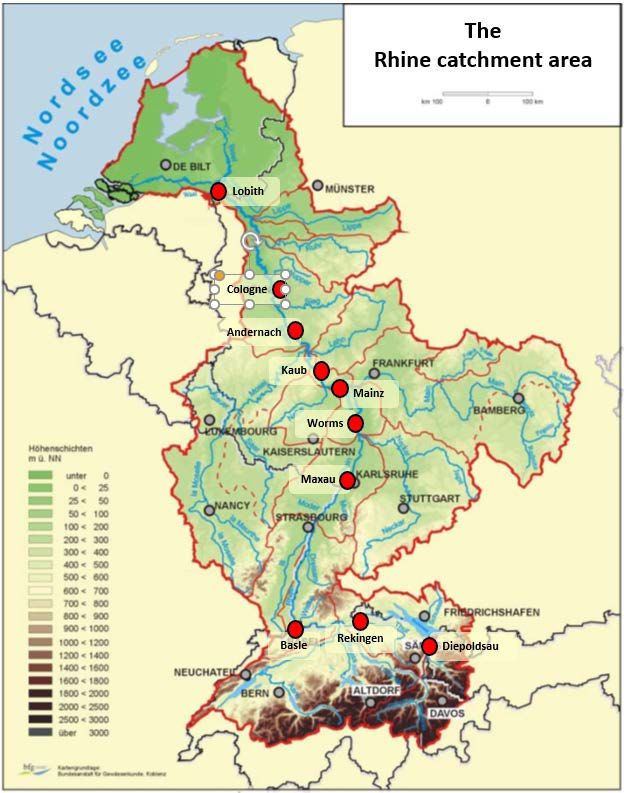
Imprint

Publisher:

International Commission for the Protection of the Rhine (ICPR)
Kaiserin-Augusta-Anlagen 15, D 56068 Koblenz
P.O. box 20 02 53, D 56002 Koblenz
Telefone +49-(0)261-94252-0, Fax +49-(0)261-94252-52
E-mail: sekretariat@iksr.de
www.iksr.org

© IKSR-CIPR-ICBR 2018
ICPR CIPR ICBR
Inventory of the
low water conditions on the Rhine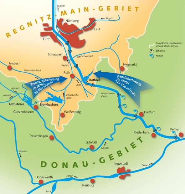
ICPR CIPR ICBR ICPR Expert Group "Low Water" (EG LW) Chair: Gerhard Brahmer (HLNUG) CH: Caroline Kan (FOEN) F: Anne Toussirot (DREAL) DE: Herbert Walter (WWA Aschaffenburg) LUX: Noémie Patz, Daniel Göhlhausen (Administration de la Gestion de l’Eau) NL: René van den Heuvel (Rijkswaterstaat) AT (informal involvement): Ernst Überreiter (BMNT) FL (informal involvement): Elija Kind (LLV) CCNR (Observer): Kai Kempmann CHR (Observer): Eric Sprokkereef Alsace Nature (Observer): Jean Wencker WWF NL (Observer): Bas Roels ICPR secretariat: Anne Schulte-Wülwer-Leidig, Adrian Schmid-Breton, Dominique Falloux, Isabelle Traue, Fabienne van Harten, Marianne Jacobs 248en 2
ICPR CIPR ICBR
Report of the EG LW
"Inventory of the low water conditions on the Rhine"
Table of contents
List of figures ........................................................................................................ 4
List of tables ......................................................................................................... 5
List of appendices .................................................................................................. 6
1. Summary ....................................................................................................... 7
2. Reason and problem ........................................................................................ 9
2.1 Reason and problem ......................................................................................... 9
2.2 Mandate of the Low Water Expert Group ............................................................. 9
3. Existing investigations in the Rhine area, subcatchment areas and other river basins
....................................................................................................................10
4. Terminology, definitions and procedures ............................................................13
5. Data Bases and Methods .................................................................................13
5.1 Measuring point selection and hydrological data basis .........................................13
5.2 Low water parameters .....................................................................................15
5.3 Evaluation and analysis methods ......................................................................15
6. Inventory ......................................................................................................16
6.1 Hydrological conditions in the Rhine area ...........................................................16
6.2 Inventory of the influence of the discharge conditions (abstractions, discharges,
diversions, water retention and time-delayed water release) ................................17
6.3 Inventory of the effects of low water on the Rhine ..............................................21
6.4 National low water management.......................................................................26
7. Investigation of historical gauge measurement series on the Rhine .......................30
7.1 Long-term behaviour of the low-water characteristic values .................................30
7.2 Reference period and low water parameters .......................................................34
7.3 Low water discharges ......................................................................................37
7.4 Low water durations .......................................................................................42
7.5 Description and classification of selected historical low water events (example: the
low water August/September 2003) ..................................................................44
8. Possible effects of climate change on future low water conditions on the Rhine.......45
8.1 Results from available investigations in the Rhine area ........................................45
8.2 Investigation of the discharge projections COSMO-CLM4.8-A1B ............................48
8.3 Effects to be considered under the aspect of low water prevention ........................49
9. Low water monitoring .....................................................................................50
9.1 Derivation of a classification of low water conditions ...........................................50
9.2 Validation of low water classification using historical time series ...........................51
10. Conclusions ...................................................................................................54
Literature ............................................................................................................56
Appendices ..........................................................................................................60
248en 3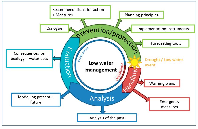
ICPR CIPR ICBR List of figures Figure 1: Location of the examination gauges on the Rhine including long-term average low-flow discharge on 7 consecutive days (MNM7Q) ..................................................14 Figure 2: Typical discharge regime in the Rhine catchment area according to Pardé; reference period 1961-1990...................................................................................17 Figure 3: Significant abstractions and diversions of water on the Rhine and in the catchment area ....................................................................................................20 Figure 4: Danube-Main transfer system ...................................................................21 Figure 5: Simplified interactions between low water and water uses............................21 Figure 6: Cycle of low water management and related fields of action .........................26 Figure 7: National displacement series Netherlands ..................................................29 Figure 8: Discharge hydrographs for the low water event in August/September in the 2003 water management year ...............................................................................33 Figure 9: NM7Q annual values at the Diepoldsau gauge and detected break points .......34 Figure 10: NM7Q annual values at the Maxau gauge and detected break points ...........35 Figure 11: NM7Q annual values at the Kaub gauge and detected break points .............35 Figure 12: NM7Q annual values at the Cologne gauge and detected break points .........36 Figure 13: Trend analysis of the NM7Q series at the Basle gauge ...............................37 Figure 14: Trend analysis of the NM7Q series at the Cologne gauge ............................38 Figure 15: Trend analysis of the NM7Q series for the summer half-year (April-September) at the Mainz gauge ...............................................................................................39 Figure 16: Trend analysis of the NM7Q series for the winter half-year (October-March) at the Mainz gauge ...................................................................................................40 Figure 17: Annual series of the parameter shortfall duration MaxD (in days) for the Kaub gauge .................................................................................................................44 Figure 18: Retrospective monitoring at the Basle, Kaub and Lobith gauge ...................51 248en 4
ICPR CIPR ICBR List of tables Table 1: Storage volumes of the reservoirs in the catchment area of the Rhine ............18 Table 2: Overview of the low water events 1920 to 2015 on the Rhine with indication of the return periods (statistical probability of occurrence) of the smallest discharge amount "NM7Q" and the maximum shortfall duration "MaxD"
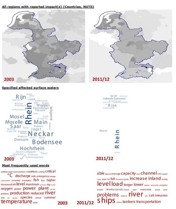
ICPR CIPR ICBR List of appendices Appendix 1: Comparison of the effects of low water events in 2003 and 2011 based on the European Drought Impact Inventory (EDII) ........................................................61 Appendix 2: Descriptions of selected low water events ..............................................62 Appendix 3: Presentations of the low water durations (MaxD) ....................................81 Appendix 4: Validation of low water classification using historical time series ...............86 248en 6
ICPR CIPR ICBR 1. Summary The low water event in the extreme summer of 2003 with ecological adverse effects on the Rhine as well as further subsequent more moderate events have pushed the low water problem into the public perception once again after a period with fewer low water events since the beginning of the 1980s. The effects of climate change can also change the genesis and extent of low water events. In the 15th Conference of Rhine Ministers in 2013, this topic was adopted and anchored in the ICPR Working Programme for 2016- 2021. To work out a common understanding of low water situations for the states adjacent to the Rhine, and in particular their cross-border effects, as well as to develop cooperation possibilities, the Expert Group Low Water was commissioned to take stock of and analyse existing knowledge on low water events in the Rhine area. The focus is on the low-water discharges on the Rhine, whose genesis and characteristics are naturally determined by the hydro-meteorological conditions in the catchment area. What the various definitions of the term "Low Water" (or “low flows”) have in common is that the water level or discharge falls below a certain threshold. Accordingly, for this comparative inventory, discharges were analysed whose statistical low-water parameters are to be considered in relation to related discharge thresholds for a number of gauging stations along the Rhine. The most widely used characteristic was the NM7Q, the lowest arithmetic mean discharge of 7 consecutive days of a reference period (year), and corresponding parameters for longer periods. To arrive at comparable threshold values along the Rhine, these parameters were evaluated with extreme value statistics at 10 examination gauges from Diepoldsau above Lake Constance up to and including Lobith at the German-Dutch border and threshold values regarding their respective occurrence probability (T = 2, 5, ... up to 100-year) were derived. The low water event duration aspect was taken into account by analysing the number of contiguous days with discharges below these thresholds. The quantitative proportions from different sub-basins of the Rhine are significant for the natural low-water discharge. The gauge-related measured value evaluations along the Rhine also illustrate the significance of the discharge proportion from the Alps and Alpine foothills, including in the low water range, which accounts for around half of the average low water discharge even in the Netherlands. In addition, the changing discharge regime with a winter minimum in the nival area (to Basle) and summer minimum in the pluvial area (below Worms) creates a certain resilience against extreme low water events for the entire Rhine. The low water run-offs on the Rhine is influenced by abstractions and diversions of water as well as by the storage management. Significant water transfers take place from the Inn to the Rhine area (7.8 m³/s) and from the Danube to the Main/Rhine area (up to 16 m³/s). Abstractions from the Rhine area benefit the Ticino area at around 2 m³/s and the Rhône area at around 3 m³/s. Direct withdrawals from the Rhine can be quantified on the northern Upper Rhine with up to 1.5 m³/s for groundwater infiltration and about 5 m³/s for agricultural irrigation. As a result of the above measures, the Rhine is gaining with regard to total discharges. An even more significant positive influence on the low water discharges on the Rhine can be seen in the management of storage areas for energy generation in the Alps and Alpine foothills. More than 1.8 billion m³ of storage space are used there to retain accumulating water in the summer and to generate energy during the low water period that prevails on the Rhine in winter. The low water discharges of the Rhine in winter are thereby increased by an order of magnitude of up to 100 - 120 m³/s. Low water has direct effects on water quality and ecology, and impacts caused by use relate to shipping, power generation, industry, agriculture, tourism and leisure, as well as infrastructure safety. No serious long-lasting negative effects on the water quality of the Rhine have been found for the main stream of the Rhine during low water events. This is particularly attributable to the enormous efforts in wastewater treatment over the past decades. Ecological problems occur especially when there are summer low water events, combined with elevated water temperatures and the associated low oxygen levels (fish and mussels 248en 7
ICPR CIPR ICBR dying in 2003). As part of the preparation of the report, there was coordination with the ICPR Working Groups "Ecology" (WG B) and "Water Quality/Emissions" (WG S). Inland waterway transport and the persons and businesses that depend on it show a cross-border impact at low water levels, with associated negative economic consequences and supply bottlenecks for energy and raw materials. For the water supply in the Netherlands, salinisation of the surface water can occur at low water due to the ingress of seawater, and this can lead to the cessation of drinking water abstraction or a restriction of abstraction for the agricultural water supply. Energy production is affected, on the one hand, by reduced production at hydropower plants and, on the other hand, by restrictions in the abstraction of cooling water or in the discharge of waste heat. This can also lead to restrictions for industry and commerce. At low water, some instabilities may occur in peat dykes in the Netherlands. According to the analysis of historical discharge series, low water levels on the Rhine were much more pronounced in the first half of the last century and occurred with lower discharges and longer shortfall periods than in the last 50 years. With regard to the low water discharges, a significantly increasing trend can be determined for the Rhine from Diepoldsau to Andernach for the entire period from 1901 to 2010. This trend is not homogeneous for the last approximately 100 years, but is based on a break point around the period of 1960-1970, which is mainly attributed to the influence of storage management in the Alpine region, which has caused a change in low-water discharge from 1960-1970. The increasing trend of annual precipitation in the 20th century for the Rhine catchment area may also be contributing to the observed trend. No significant trends can be detected for the low-water discharges for the period from 1961 to 2010. The current perception of low water events is influenced on the one hand by the long absence of significant low water events and on the other by increased vulnerability. The low-water discharge developments due to climate change in existing discharge projections for the period 2021-2050 for the Rhine range from decreases of 10% to increases of 10% and show no clear development. For the remote future (2071-2100), the discharge projections for the hydrological summer half-year consistently show significant low water discharge reductions. For a pessimistic scenario with low water decreases of 5 to 10% of the MNM7Q (long- term mean low water discharge on 7 consecutive days) for the period 2021-2050, there are greater decreases from 7 to 14% for 2 to 50-year low water discharges on an increasingly annual basis. The decrease in the discharge is accompanied by a significant extension of the low water duration. In the future, low water events in the summer months on the Rhine could have increasingly negative ecological effects. With low discharges, water temperatures can increase more in summer. An example of this is the low water events in 2003 and 2006. According to research by the ICPR Expert Group STEMP, summer water temperatures on the Rhine are expected to rise by 1.5 °C in the near future and over 3 °C in the remote future. For the near future (2021-2050), this means, among other things, a doubling of the days with water temperatures above 25 °C (ecologically critical threshold) in the Rhine. It makes sense to set up a low-water monitoring system for the Rhine for uniform monitoring of these phenomena across the entire river. Current events can be classified by direct comparison and possible changes in the low-water discharge can be determined. Based on a detailed analysis of the historical discharge series, discharge-related threshold values for the classification of the low water situation into five characteristic states from "normal" to "extremely rare low water" were derived for the Rhine in coordination with the International Commissions for the Protection of the Moselle and the Saar (ICPMS). The suitability of this classification, which provides a differentiated classification of low water events, has been validated by applying it to historical discharge time series. Extreme events can be clearly distinguished from smaller events, with sufficient sensitivity to minor low water events. 248en 8
ICPR CIPR ICBR
The key message is that although the low water events on the Rhine have not worsened
in the last 100 years, today they have a greater impact on numerous uses (shipping,
industry, agriculture, energy production, etc.). The demand for water and the socio-
economic influences could increase in the Rhine catchment area. In addition, low water
events can have a negative impact on aquatic ecosystems, especially if they occur at the
same time as higher water temperatures. Some climate projections forecast more
frequent low water events in summer with increased water temperature in the future. All
these points are reasons to continue monitoring developments on the Rhine.
2. Reason and problem
2.1 Reason and problem
At the 15th Conference of Rhine Ministers in 2013, the missions for the ICPR were
formulated for the coming years. These missions have been prepared and specified in the
ICPR work programme 2016-2021. The issue of low water was included in the topic of
"Climate change and adaptation". It was noted in that regard that the topic of low water
needs to be made more concrete. In the first step, the low water events are to be
analysed in more detail. Both hydrological and qualitative aspects (temperature and
chemistry) are relevant to low water.
The WG H (Floods) was asked to record and analyse in detail the hydrological aspects of
low water events. The WG S and WG B are reviewing the qualitative aspects of low
water.
To this end, the WG H has set up a new Expert Group Low Water (EG LW), which met for
the first time on 17 January 2017.
Problem
Currently, the Rhine states do not have a consistent perception of low water events, even
though (extreme) low water situations occur regularly. Also, there is no common
understanding of the relevance of cross-border effects of low water or of the possibilities
for cross-border cooperation in dealing with bottlenecks caused by low water.
The establishment of the EG LW serves as a prelude to this with the achievement of a
common overview of low water in the Rhine.
The EG LW has the mission of taking stock of the existing knowledge about low water
events in the entire Rhine catchment area, analysing it and monitoring the possible
corresponding developments at the level of the Rhine catchment area. Possible effects of
climate change are thereby taken into account.
It is also the task of the EG LW to actively share the resulting knowledge with other
Working Groups (in particular S and B) in order to be able to assess/evaluate the impact
of low water events on the ecological function and the use of water systems by humans.
2.2 Mandate of the Low Water Expert Group
The Expert Group Low Water (EG LW) is mandated to carry out the following tasks. This
report documents the implementation of activities for the realisation of these tasks. At
the same time, this report is one of the planned products developed by the EG LW in
accordance with its mandate.
1. Inventory of knowledge about low water in the Rhine IRBD
- Analysis of the low water situation by means of the gauge-related evaluation
of measured data (long-term);
- Analysis and description of selected extreme low water events;
- Compilation of influences on and concerns caused by low water;
- Reflections on the effects of climate change on low water through the use of
the results of the EG KLIMA/ CHR-Rheinblick2050 and transfer of the change
factors determined there;
- Exchange of information on national low water monitoring, on aspects of low
water management including cross-border aspects
248en 9ICPR CIPR ICBR
2. Establishment of low water monitoring (measuring network and monitoring
parameters)
3. Exchange of information with the other Working Groups WG S and WG B and,
if applicable, further uses regarding the respective specific concern.
4. Preparation of a contribution (report) for WG H's reply to the mandate of the 2013
Conference of the Rhine Ministers (and in the run-up to the next Conference of the
Rhine Ministers). Preparation of a contribution for the recommendation by WG H
on the work results, the state of knowledge and on the issue of the
relevance/necessity of an ICPR low water management plan
3. Existing investigations in the Rhine area, subcatchment areas
and other river basins
Due to the importance of the Rhine as one of the largest rivers in Europe, studies on the
discharge conditions are of great interest. A basic and comprehensive compilation of the
discharge conditions on the Rhine and its main tributaries as well as the conditions in the
Rhine catchment area was presented by way of an example in the so-called "Rhine
monograph" ("Rheinmonographie")(CHR, 1978) with maps, texts and tables. This already
contains information on the extremely low water year 1947 as well as "Reflections on the
low water periods of 1959 and 1964" (Betrachtungen über die Niedrigwasserperioden von
1959 und 1964).
Buck et al. (1993) summarises the effects of human activity on the discharge events on
the Rhine. This influence on the low water events is illustrated in particular by the
development of dam expansion with a total storage volume above Basle of more than 1.8
billion cubic meters (moderation of discharge). An analysis of the discharge conditions on
the Rhine and its tributaries for the entire 20th century was presented by Belz et al.
(CHR, 2007). For the first time, the quantitative-hydrological developmental dynamic for
the entire Rhine basin was analysed and documented over this kind of long uniform
period. In addition to developments in the discharge regime and the medium and high-
water conditions, developments in low water conditions in the 20th century were also
examined. The summary of the results for low water describes this development and
comes to a clear conclusion:
"The observed low water extremes have become more moderate during the 20th century
in the Rhine area. This applies particularly to the Rhine itself and its large tributaries;
there are stronger regional differentiations in the catchment areas of downstream,
smaller tributaries. In light of the interrelationships described above, it is understandable
that this moderation is taking place more intensively where the winter season represents
the actual low water season, that is, in the southern, nival Rhine area. In contrast, in the
pluvial low mountain regions and lowland regions, where the low water season is usually
in late summer and autumn, the trend towards moderation is absent, as there is little
change in precipitation in these months. Only other influences, as shown by the example
of transfer gains on the Main, justify exceptions to this configuration. "(Belz et al., 2007)
The KLIWAS project investigated the effects of climate change on waterways and
shipping in Germany (BMVBS, 2009). KLIWAS comes to the following conclusion: "With
regard to the low water extremes, this means a significant increase in discharge and thus
moderation for the southern Rhine area, where the winter months are usually the time
with the lowest water supply for surface waters. North of the Main, on the other hand,
the months with the lowest water levels are in late summer and autumn - here there is
an undirected, sometimes even slightly decreasing trend in the low water extremes.
However, this slight intensification of the low-water extremes in the northern Rhine basin
is so weak that it cannot be statistically substantiated as being significant" (BMVBS,
2009).
In the project "Rheinblick 2050" (Görgen et al., 2010), a comprehensive ensemble of
climate projections for the 21st century was used to model the future discharge
conditions in the Rhine basin that are influenced by climate change. The summary comes
to the following conclusion on the subject of low water: “With respect to low flow we see
no strong development in the near future; while most ensemble members show no clear
248en 10ICPR CIPR ICBR tendency in summer (ranging from +/-10%), winter low flow is even projected to be alleviated (0% to +15%). For the remote future, the change signal is stronger in summer, with a tendency towards decreased low flow discharges (-25% to 0%), while for winter no clear signal is discernible (bandwidths are mainly from -5% to +20% depending on discharge diagnostic and gauging station)” (Görgen et al. 2010). In the projects “Abflussregime des Rheins” [Discharge regime of the Rhine] (Belz et al., 2007) and “Rheinblick2050” (Görgen et al., 2010) it became clear that there was a lack of reliable quantification of snow and glacier melt ratios in the total discharge of the Rhine. This gap was closed by the CHR project "Abflussanteile aus Schnee- und Gletscherschmelze im Rhein und seinen Zuflüssen vor dem Hintergrund des Klimawandels" [The snow and glacier melt components of the streamflow of the River Rhine and its tributaries considering the influence of climate change] (Stahl et al., 2016). The daily discharge portions attributable to snow and glacier melt for different gauges throughout the Rhine for the period 1901 - 2006 are analysed and presented. As a result, the extent of these effects can also be quantified for the low-water discharge. In particular, the results from Görgen et al. (2010) were taken into account in a scenario study by the EG KLIMA of the ICPR for the discharge regime of the Rhine (ICPR, 2011). On the basis of the air temperature and discharge developments determined in the scenario study for the discharge regime of the Rhine (ICPR, 2011), the ICPR (STEMP Expert Group) first published a report in 2014 on the estimation of the effects of climate change on the development of Rhine water temperatures in the near future (2021-2050) and the remote future (2071-2100) (ICPR, 2014). This report supplements the ICPR publications on the long-term development of the Rhine water temperature in the period 1978-2011 (ICPR, 2013a) and the possible effects of these changes on aquatic communities (ICPR, 2013b). The latter shows that in particularly warm summers with very low discharges, the water temperature can rise to such an extent that there can be negative effects on the aquatic ecosystem (ICPR, 2013b). In addition, the ICPR has published the following reports, which show both effects and measures for past low water events: Report no. 142 "Wärmebelastung der Gewässer im Sommer 2003 Zusammenfassung der nationalen Situationsberichte" [Thermal load on the waterway in summer 2003 - summary of the national situation reports] (ICPR, 2004), Report no. 152 "Maßnahmen bezogen auf die Wärmebelastung des Rheins in extremen Hitze- und Trockenperioden: Überblick und Zusammenstellung der Länderberichte" [Measures related to the thermal load on the Rhine in periods of extreme heat and drought: overview and summary of the national reports] (ICPR, 2006) and Report no. 198 "Niedrigwasserperioden 2011 im Rheineinzugsgebiet" [Low water periods in the Rhine river basin in 2011] (ICPR, 2012). In the German Working Group KLIWA (climate change and water management) low water conditions and developments were investigated for a variety of gauges in Baden- Württemberg, Bavaria and Rhineland-Palatinate (Working Group KLIWA, 2009). In a collaboration between the KLIWA partners and the state of Hesse, discharge projections with evaluations were also compiled for low water characteristic values for the Rhine (HYDRON, 2015). In Belz (2005) and on the Undine information platform (www.undine.bafg.de) (BfG, 2016), descriptions of past low-water events in the Rhine basin are compiled. For the Moselle region, a report on the inventory of low water problems was presented in the ICPMS (International Commissions for the Protection of the Moselle and the Saar) (ICPMS, 2014). In addition, the project FLOW MS 2009 to 2013 (ICPMS, 2009-2013) was dedicated to the topic "Floods and low water management in the Moselle and Saar catchment areas". Operational low water monitoring is currently being carried out by the ICPMS and an updated report on low water is expected to be available in 2018. In addition, there was coordination between the ICPR and the ICSMS as part of the present ICPR study. A comprehensive compilation of fundamentals up to the low water management and measures in different sectors was compiled for Bavaria, which has a very large share of the Main catchment area (BY-LfU, 2016). 248en 11
ICPR CIPR ICBR With the support of the Swiss Federal Office for the Environment (FOEN), the ICPR and the Central Commission for the Navigation of the Rhine (CCNR), i.e. the three "Rhine commissions", the CHR held the international symposium "Low flows in the Rhine catchment" on 20 and 21 September 2017 in Basel, with 70 participants. The focus was on the exchange between science and practice and dealing with hydro-climatic processes and parameters and the effects of low water. For instance, the first results from the ICPR and ICPMS Expert Groups on low water and information from the CCNR on the effects of low water on shipping were presented. In addition, examples of monitoring, management and moderating measures were shown. It also became obvious at this symposium that although the low water events on the Rhine have not worsened in the last 100 years from a hydrological point of view, today they have a greater impact on numerous uses (shipping, industry, agriculture, energy production, etc.). It is assumed that the demand for water and the socio-economic influences are increasing in the Rhine catchment area. It is assumed that in the future there will be more frequent low water events in summer in conjunction with higher water temperatures. The results of the symposium served as input for the work of the three "Rhine Commissions" concerned. More information can be found at www.chr-khr.org (CHR, 2017) and www.iksr.org (under "Events"). From the above-mentioned projects and studies, there are extensive results and methodological approaches, which were also included in the present study. Although most of the other European river commissions continue to prioritise the topic of "flood", the management plans according to WFD, annual reports and various documents or strategies on the impact of climate change or adaptation to it also mention the issue of low water (or drought). Noteworthy examples include the International Commission for the Protection of the Danube River (ICPDR) with an article on the dry period in 2003 and a detailed report on influences and effects of the 2015 drought on uses (based on a survey of states) or the International Meuse Commission (IMC) with a thematic workshop in November 2003 with the participation of 60 representatives from public authorities, the private sector, stakeholders and universities (result: Introduction of an automatic and permanent information notification system in the event of low water situations). The International Commission for the Protection of the Elbe (ICPER) is devoting the 18th Magdeburg Water Conservation Seminar to the issue of "Low Water and Demands on Water Utilisation in the Elbe River Basin" (18/10 - 19/10/2018 in Prague). In addition, the Hydrology Expert Group of the ICPE recently published a report on the low water situation in 2015 in the catchment area of the Elbe (ICPER, 2017). At a European level, the issue of water scarcity and drought, which is also relevant with regard to low water, is mainly covered by the Water Framework Directive (WFD) and its requirements for achieving a good water status (surface water and groundwater), including water abstraction. These requirements should be included in the management plans to be set up in accordance with the WFD and related programmes of measures. In 2007 the EU published the communication "Addressing the challenges of water scarcity and droughts in the European Union" (EU Commission, 2007). The "Drought Management Plan Report" (EU Commission, 2008) describes detailed drought management approaches. Here, among other things, compulsory components of a drought management are mentioned: 1) a drought early warning system, 2) drought indicators and limit values for various drought stages, 3) measures to be taken in the various drought stages to achieve specific objectives. A strategy (EU Commission, 2012), a network of experts on this topic (EU Commission, 2008) and the European Drought Observatory of the Joint Research Centre (JRC) of the EU (JRC, 2017, Cammaleri, 2017) were set up. The European Environment Agency (EEA, 2009) and various research projects (DROUGHT-R & SPI, 2015) are addressing this topic. The European Drought Impact Inventory is an inventory of drought and drought effects across Europe. It also contains information on past low-water events in the Rhine catchment area (see also Section 6.3 and Appendix 2) (DROUGHT-R & SPI, 2015; Kohn, 2017). Some interesting technical reports or guidelines, such as the Drought Management Plan (EU Commission, 2008) and the document "River Basin Management in Climate Change", which also includes information on low water (EU Commission, 2009), have been prepared and published in the context of the Common Implementation Strategy (CIS) to support the implementation of the WFD in the member states. 248en 12
ICPR CIPR ICBR On a global scale, among others, the Manual on Low-Flow Estimation and Prediction (WMO, 2009) and the Integrated Drought Management Program (IDMP) (WMO - GWP, 2014), which provide valuable information on low water estimation and analysis and integrated drought management, are also worthy of mention. In this context, in 2013, the UN launched the initiative “Capacity development to support national drought management policies” (UN, 2013; BY-LfU, 2016). In December 2017, der UN-ECE “International Workshop on Water Scarcity: Taking action in transboundary basins and reducing health impacts” took place (UN-ECE, 2017). The preliminary results of the EG LW were presented on this occasion. 4. Terminology, definitions and procedures Low water levels in rivers are the result of overlapping hydrological and meteorological events. The decisive factor for the development of a low water level is a long dry period associated with declining groundwater discharge from the catchment area. The causes of low water are mainly due to below-average or a complete lack of precipitation or a high retention of precipitation in the form of snow and ice. The German DIN 4049 standard designates "low water" as a "condition in a body of surface water, where the water level or the flow has reached or fallen below a certain value (threshold value)". This definition allows for differing views of the low water and can lead to very different assessments of an event, depending on whether the water level or the discharge is the variable of interest and depending on where a particular type of use is affected in a certain location. The impact is associated with a "threshold value", which either corresponds to a hydrological classification, or below which a use is either increasingly impaired (e.g. shipping), or must be immediately stopped in terms of a limit value (e.g. water drainage, water abstraction). Significant vulnerabilities with low water on the Rhine have been queried in the states and compiled into an inventory. Significant anthropogenic influences on discharge and low water discharge events were also researched and assigned to the respective sections of the Rhine. Low water levels can be described by different parameters and their probability of occurrence (see Chapter 5). The occurrence of low water levels or discharges is a first obvious feature of low water, and it is expressed even more strongly as the event continues. These parameters can be determined for different reference periods (e.g. summer season) or measurement series and compared with long-term averages or threshold values. Consequently, for the present comparative study of low water conditions on the Rhine, discharges were examined, and these are then compared with statistical hydrological low water characteristic values as threshold values. Thus, the extent and development of the occurrence of low water over the entire length of the Rhine can be represented. The discharge threshold values and low water parameters used can basically be converted into water levels via the water level discharge relationship at the gauge. These water levels, however, only apply to the gauge cross section and would have to be transferred to the respective location for the classification of local impairments. To define low water classes (as threshold values) for monitoring, the available time series were limited following a homogeneity analysis to a 50-year reference period, which is meaningful for the current situation. The approach followed is explained in Chapter 5. In Chapter 7, the low water classes defined were used to retrospectively analyse and illustrate the occurrence of low water in the historical time series. 5. Data Bases and Methods 5.1 Measuring point selection and hydrological data basis The study in the EG LW focuses on the description and analysis of the low water conditions along the Rhine, taking into account the influences from the catchment areas of the tributaries. For the individual sections of the Rhine between which hydrological changes can then occur due to larger tributaries, the following reference gauges have 248en 13
ICPR CIPR ICBR
been determined, whose values are determined by the upstream catchment area and are
significant up to the next gauge with the exception of the Diepoldsau gauge (see Fig. 1):
Diepoldsau gauge on the Alpine Rhine upstream of Lake Constance
Rekingen gauge on the Upper Rhine downstream of Lake Constance and the inflow of
the Thur
Basle gauge on the Upper Rhine downstream of the inflow of the Aare
Maxau gauge on the Upper Rhine with the inflows from the Black Forest and Vosges
Worms gauge on the Upper Rhine after the inflow of the Neckar
Mainz gauge on the Upper Rhine after the inflow of the Main
Kaub gauge on the Middle Rhine after the inflow of the Nahe
Andernach gauge on the Middle Rhine after the inflow of the Lahn and Moselle
Cologne gauge on the Lower Rhine after the inflows of the Ahr and Sieg
Lobith gauge on the Lower Rhine after the inflows of the Wupper, Erft, Ruhr and Lippe to
the German-Dutch border. Downstream from Lobith the water in the Netherlands is
distributed over 3 arms of the Rhine.
These reference gauges are hydrological gauges (gauges with discharge analysis) for
which long-term discharge time series (measured discharges or discharges calculated on
the basis of the water level) are available. (see fig. 1). Since daily average discharges
are usually examined for low-water investigations and these represent a sufficiently high
temporal resolution due to the catchment area sizes of the Rhine gauges, a database was
compiled of daily average discharges from 1900 to 2015, as far as data were available.
Data are available only from 1919 onwards for the Diepoldsau gauge and only from 1931
onwards for the Mainz gauge.
The
Definition of the
Rhine catchment area
investigation gauges
Low water discharge at Rhine gauges:
(1961 -2010)
Lobith 1095 m³/s
Cologne 1028 m³/s
Andernach 998 m³/s
Kaub 851 m³/s
Mainz 850 m³/s
Worms 720 m³/s
Maxau 645 m³/s
Basel 527 m³/s
Rekingen 238 m³/s
Diepoldsau 92 m³/s
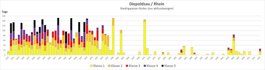
Figure 1: Location of the examination gauges on the Rhine including long-term average
low-flow discharge on 7 consecutive days (MNM7Q) (changed according to Federal
Institute of Hydrology [Bundesanstalt für Gewässerkunde - BfG])
248en 14ICPR CIPR ICBR 5.2 Low water parameters The extent of a low water event is comprehensively characterised on the one hand by a low discharge and on the other hand by the length of the duration of the low discharges by means of a discharge hydrograph. Statistical analyses and comparative studies require parameters derived from the discharge hydrographs that describe the low water. Based on the daily average discharges in respective reference periods, the smallest daily average discharge from a period to be considered (1901 to present) (NNQ), the lowest daily average discharge from a reference period (NQ) or the mean lowest daily average discharge from a number of years (MNQ) is used. To limit disturbing effects in the analysis due to influenced individual daily average values or such values afflicted by measurement errors, parameters from several consecutive days are determined. For example, a common value is the lowest arithmetic mean of 7 consecutive days (NM7Q) in a reference period (e.g. year). The MNM7Q for a long homogeneous period was used as the threshold value was in this analysis (see Figure 1 and Chapter 5.3). The duration of a low water event is determined by the number of days on which a threshold value QS (to be determined) is fallen short of. This threshold value may be dictated by local use or defined for comparative studies by statistical hydrological parameters. For the low water duration parameter, the longest uninterrupted duration of falling short of a threshold value within a time period (MaxD) is distinguished from the sum of all durations of falling short of a threshold value within the time period (SumD) (DVWK, 1983). A more complex low water parameter is defined as the discharge deficit (DVWK, 1983). This is understood to be the maximum discharge deficiency between a threshold value Qs and the discharge hydrograph within a time interval (MaxV [m³]) or the sum of all discharge deficiencies between a threshold value and a discharge hydrograph (SumV [m³]). The "Water Year" from 1 April to 31 March of the following year was used as the reference period for the low water characteristic values, so as not to interrupt the low water events occurring in late autumn or winter and, if applicable, not to take their values into account for two consecutive years when deriving annual series. With regard to a local impact, low water parameters can also be determined on the basis of water level values instead of discharges, but then they are not comparable with other reference gauges (on rivers). 5.3 Evaluation and analysis methods The study of low-water conditions was based on classic statistical methods or methods of low-water analysis published in regulations (DVWK, 1983; DVWK 1992). The statistical analyses and the preceding series and serialisation of the characteristic values were carried out with the HyStat programme of the Institute of Applied Water Management and Geoinformatics [Institut für angewandte Wasserwirtschaft und Geoinformatik (IAWG)]. After plausibility checking and if necessary correction of the collated data from all gauge time series, yearly series of the low-water characteristic values NMxQ (x = 1, 3, 7, 21, 60) were determined. For this purpose the smallest mean low water discharge of x consecutive days is filtered out for each year. The arithmetic average of the annual characteristic values then results in the low water characteristic values MNMxQ (MNQ, MNM3Q, MNM7Q, MNM21Q and MNM60Q) for the different low water lengths at each gauge (e.g. “long-term mean low water discharge on 7 consecutive days” MNM7Q). With the series of NMxQ values, jump analyses were performed to see if there were any changes in the behaviour of the values at any given time in the series. In the Bernier and Pettit methods that were used, a time at which the statistical character of a time series changes is sought. The determined breakpoint divides a time series into two time series sections with significantly different behaviours. Based on the results of the jump analysis and the graphical representation of the time characteristic of the characteristic values, a reference period for the current state (1961-2010) was derived from the total period under investigation (1901-2015). 248en 15
ICPR CIPR ICBR
For the study of the low water duration, the series of daily average discharges were
used to form series of absolute sums of the days per year and maximum contiguous
event days per year, which fall short of a threshold value QS. The MNM7Q parameter and
the NM7Q values of different probabilities of occurrence of the respective gauge were
selected as a threshold value, so that all Rhine gauges can be directly compared with one
another with regard to the duration of the low water event.
By means of trend analyses, time series were examined for the presence of increasing
or decreasing trends in low-flow discharge behaviour. The time series were checked with
regard to the significance of a linear trend through the adaptation of a trend line by
minimizing the least squares error of the residuals. The significance test (error probability
of 5%) was carried out with the (non-parametric) Mann-Kendall test and the t-test of the
slope coefficients of the straight line.
To classify the extent of low-water discharges and low-water durations (low-water time
spans) in terms of their probability of occurrence, the data were subjected to an
extreme-value statistical analysis. For the reference period (1961 - 2010), the values of
the annual series of low-water characteristic values were adjusted to a theoretical
probability distribution, from which the corresponding quantiles for a T-annual event
were output (T = 2, 5, 10, 20, 50, 100 years). A classic probability analysis was
carried out for the low-water parameters NMxQ, for which there is a value for each year.
Since individual annual values that don’t fall below the threshold value occur for the low-
water durations and the value zero occurs for these years, these series cannot be
adjusted with the usual hydrological distribution functions. Therefore, the indirect
method according to the German Association of Water Management and Land
Development (DVWK - Deutscher Verband für Wasserwirtschaft und Kulturbau e.V.)
(DVWK, 1992) was used. For this purpose, the respective shortfall duration in the
individual years is determined for a whole spectrum of threshold values. Thus, for each
shortfall duration, a sample of the associated threshold QS whose elements are greater
than zero can be obtained. After the adjustment of a distribution function, threshold
values can initially be determined as a function of the return period T and the shortfall
duration D. From this, the magnitude of the shortfall duration D which is of interest as a
function of the threshold value QS and the return period T can then be determined as an
inverse function.
6. Inventory
6.1 Hydrological conditions in the Rhine area
The discharge regime describes the overall behaviour of river discharges with regard to
the annual average over many years as well as the characteristic developments of
extreme flood and low water situations (Belz et al., 2007). Different discharge regimes
overlap one another in the Rhine catchment area (see Fig. 2).
The southern alpine area (Basle gauge) is characterised by the interplay of winter snow
cover and summer snowmelt and by relatively high summer precipitation ("snow
regime" or nival regime). Consequently, low water events occur mainly in winter
and flood events mainly in summer.
Typical of the waters that drain the low mountain area (Neckar, Main, Nahe, Lahn,
Moselle, etc. Trier gauge) is a "rain regime" (or pluvial regime). This is shown by a
dominance of winter flood and summer low water.
The overlapping of the two regimes results in an increasingly even distribution of the
discharge over the year downstream of the Rhine ("combined regime", Cologne
gauge).
248en 16ICPR CIPR ICBR
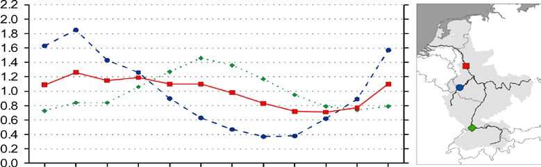
Pardé coefficient
Cologne ('combined')
Trier ('rain')
Basle ('snow')
Jan Feb Mar Apr Ma Jun Jul Aug Sep Oct Nov Dec
Figure 2: Typical discharge regime in the Rhine catchment area according to Pardé 1;
reference period 1961-1990 (ICPR, 2011)
The quantitative proportions from different sub-basins of the Rhine are significant for the
low-water events (see also 7.1). For example, the long-term average low-water
discharges from the Alpine and Alpine foothills regions measured at the Basle gauge still
provide almost three-quarters of the low-water discharges after the confluence of the
Neckar at the Worms gauge. After the confluence of the Main, the low-water
characteristic values at the Mainz gauge are still dominated by about two-thirds of the
Basle gauge, while at least about half of the low-water discharge at the Lobith gauge is
attributable to the Basle gauge. The base load of the mean low-water discharges is thus
provided by the Alpine and Alpine foothills regions (in particular by the local discharge
regime and the effect of the Alpine marginal lakes). Due to their inflow, the large
tributaries increase the low water characteristic values on average by 12% (Neckar) to
18% (Main and Moselle). Thus, pronounced low-water situations occur in the catchment
areas with a pluvial regime in the case of decreasing discharges in the Alpine/Alpine
foothills region from September/October and dry winters (or very cold winters with
predominant precipitation retention in the snow cover).
The variable components from the snow and glacier melt have a non-negligible influence
on summer low water events on the Rhine. In addition to the significant portions of the
discharge attributable to snow melt, glacial meltwater plays a considerable role in
supporting low-water phases on the Central and Lower Rhine during extreme late
summer low water phases (Stahl et al., 2016). These portions of glacial ice melt
accounted for up to one-third of the discharge in Basle and one-fifth of the discharge in
Lobith for maximum daily contributions during the event in 2003. In average conditions,
however, the influence of glacier melt in Lobith is low (ICPR CIPR ICBR Storage management Storage management, which displays seasonal redistribution and balancing dynamics with water storage during the period of excess water and depletion of storage in the demand period, is a significant anthropogenic factor and contributes significantly to reducing discharge variability despite increasing variability in precipitation. This is particularly the case upstream of Basle with the development of dam expansion (more than 1.8 billion m³ total storage volume) at the beginning of the last century up to the 1960s (see Fig. 3). Outside the Alpine region, storage management is characterised by considerably less uniform storage management objectives and is becoming less significant as an influencing factor for the Rhine. In addition to these effects, reservoirs always mean extensive artificial water surfaces with high evaporation and, in comparison with the former situation, damming of artificial lakes and sewer construction or river damming can also lead to major groundwater recharge (LAWA, 2007; Belz et al. 2007). The storage volumes (i.e. storage space or water retention capacity) of the reservoirs in the Rhine catchment are listed in Table 1. The current control in the Alpine area of the Rhine catchment area is leading to a temporal discharge shift, with the result that in the otherwise rather low-discharge winter season, the discharges and in particular the low water discharges have increased by approx. 120 m³/s (Weingartner, 2017). Table 1: Storage volumes of the reservoirs in the catchment area of the Rhine (modified according to Wildenhahn & Klaholz, 1996 in Belz et al., 2007) Rhine section or tributary Volumes [millions of m3] Sum of the volumes [millions of m3] Anterior Rhine 253.14 253.14 Posterior Rhine 289.36 542.50 Tamina 38.50 581.00 Ill (A) 183.40 764.40 Bregenzerach 8.40 772.80 Lake Constance 1.40 774.20 Thur 0.60 774.80 High Rhine (CH) 7.26 782.06 Aare 496.95 1279.01 Reuss 153.19 1432.20 Limmat 314.86 1747.06 High Rhine (D) 112.85 1859.91 Upper Rhine 27.63 1887.54 Ill (F) 24.29 1911.83 Neckar 37.99 1949.82 Main (incl. storage system of the Danube- 180.00 2129.82 Main transition: since 2000, + 64 million m3) Nahe 14.05 2143.87 Lahn 6.63 2150.5 Moselle (F) 103.58 2254.08 Moselle (D; without Sauer) 50.53 2304.61 Sauer (Moselle tributary) 71.40 2376.01 Wied 4.45 2380.46 Ahr 0.73 2381.19 Sieg 123.10 2504.29 Wupper 140.43 2644.72 Erft 51.00 2695.72 Ruhr 496.06 3191.78 Lippe 50.01 3241.79 Abstractions and diversions of water The anthropogenic measures directly affecting the discharge include direct withdrawal, abstraction and return of used water. This primarily includes the use of water for drinking water, irrigation needs or the cooling of thermal power plants. In addition, by transferring water to other catchment areas, water can be withdrawn from its original area. Such large-scale water transfers exist, for example, on the Neckar (drinking water 248en 18
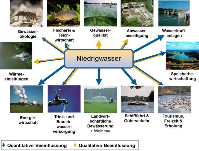
ICPR CIPR ICBR transfer from Lake Constance) and on the Main (particularly the transfer from the Danube area since the mid-1990s on the Danube-Main-transfer system including the Rhine-Main-Danube Canal for discharge support/ low-water elevation and particularly the Regnitz, which also benefits the Main) (Belz et al., 2007). The schematic diagram in Figure 3 shows the significant abstractions and diversions of wateron the Rhine and in the catchment area (source: Information from the states, ICPR (internal), 2017/2018). Approximately 2 m³/s are lost to the catchment area through transfers into the area of the Ticino and about 3 m³/s from the Aare area to the Rhône area. By contrast, the Rhine area gains almost 8 m³/s due to transfers from the Inn area. The abstraction from Lake Constance (Lake Constance remote water supply) is predominantly returned to the Rhine after the confluence of the Neckar with the wastewater quantities. Ad hoc and temporary abstractions of up to 6.3 m³/s are used in the northern Upper Rhine plain for irrigation and groundwater infiltration. Up to 15 m³/s from the Danube area (water from Altmühl and Danube, stored floods of the Altmühl) are supplied to the Rhine via the river Main, which serves for the discharge support 2 or low water elevation of the Rednitz, the Regnitz and the Main (see Fig. 4). Furthermore, up to 0.9 m³/s of additional water in the Lech estuary is pumped into the Main catchment area for drinking water. Downstream from Mainz to Lobith there are no significant abstractions and/or diversions of water. The Rhine delta begins downstream of Lobith. The river divides quickly into three arms. On the Kop van Pannerden the Rhine divides into the Waal and the Pannerden Canal. After a few kilometres, the Pannerden Canal passes into the Dutch Lower Rhine, and at Arnhem the IJssel branches off from this river. The Dutch Lower Rhine and the Waal finally flow into the North Sea. The IJssel flows into the IJsselmeer. Excess water from the IJsselmeer is channelled through sluices into the Wadden Sea. All of the above-mentioned water flows, in particular the abstraction for irrigation and the water transfer from the Danube to the Rhine, do not occur at the same time and evenly, but it can be seen from the compilation that the balance for the Rhine is positive overall. This positive balance still needs to be supplemented by the quantifiably much more significant support of winter low-flow discharge through the storage management in the Alpine region (see above). 2 Comment: The Danube-Main transfer occurs not only at low water periods, but - with variable discharges - throughout the year. The purpose of the transfer is, among others, to counter possible disadvantages for the economic development in Franconia (sufficient provision of water, thus support for the water quality). 248en 19
You can also read