New Forest Waterside Draft local cycling and walking infrastructure plan - June 2021
←
→
Page content transcription
If your browser does not render page correctly, please read the page content below
New Forest Waterside
Draft local cycling and walking infrastructure plan

June 2021
About                                                                   About Hampshire
Sustrans                                                                County Council
Sustrans is the charity making it easier for people to walk             We are the local Highway Authority. Our in-house consultancy,
and cycle.                                                              Hampshire Services, was commissioned to deliver this Local
                                                                        Cycling and Walking Infrastructure Plan with input from New
We are engineers and educators, experts and advocates. We               Forest District Council as the Local Planning Authority.
connect people and places, create liveable neighbourhoods,
transform the school run and deliver a happier, healthier commute.      Through Hampshire Services we offer professional services
                                                                        to other authorities and organisations. We cover our costs
Sustrans works in partnership, bringing people together to find         and our partners benefit from economies of scale, helping to
the right solutions. We make the case for walking and cycling           protect frontline services for all. We have a 500-strong team
by using robust evidence and showing what can be done.                  of specialists in transport, engineering, environmental
                                                                        services, research and economic development to help
We are grounded in communities and believe that grassroots              you deliver your project.
support combined with political leadership drives real
change, fast.                                                           Get in touch at shared.expertise@hants.gov.uk
                                                                        or visit our website hants.gov.uk/sharedexpertise
Join us on our journey. sustrans.org.uk

Head Office
Sustrans
2 Cathedral Square
College Green
Bristol
BS1 5DD

© Sustrans May 2021
Registered Charity No. 326550 (England and Wales) SC039263 (Scotland)
VAT Registration No. 416740656

                                                                                                                                        New Forest Waterside LCWIP May 2021   2
Foreword from Councillor Humby

                                    Hampshire County Council is committed to                We have been challenged in recent years by walking and           this new guidance, some of the high-level suggestions will
                                    delivering better environments for people to walk       cycling advocates to do better. This has been tough without      need further development. All future schemes will be designed
                                    and cycle both for their day-to-day journeys, and       steady sources of funding, but we have always shared their       to comply with LTN1/20 and will be developed in line with our
                                    when spending time in our public spaces. Walking        ambition. This LCWIP, and five others like it, have been         new walking and cycling principles.
                       and cycling are a big part of the solution to a number of the        developed alongside successful bids to the Government’s
                       greatest challenges that we face including climate change; air       ‘Transforming Cities Fund’. Building on this foundation, we      Walking and cycling have the potential to replace shorter
                       pollution; obesity; equality of opportunity and access for all.      have committed to a future program of LCWIPs covering every      car trips made in Hampshire, including around a third of all
                                                                                            borough and district in Hampshire.                               commuting trips. With commuting trips representing around
                       The disparity between the number of people who want to walk                                                                           16% of all trips, the overall potential is far greater. Walking
                       and cycle and the number who actually have been regularly            Over the last year our officers, stakeholders and cross-party    and cycling are practical everyday ways of travelling, for even
                       able to do so has never been more obvious than during this           elected members have worked together to develop a common         just part of a journey, that can help to make us
                       year’s national lockdown. As motor traffic reverted to 1950s         understanding of what improvements are needed. Together,         healthier, happier, greener, and more equal, and
                       levels, our residents explored and rediscovered their local areas    we have proposed the ten bold new walking and cycling            we look forward to supporting increases in these
                       on foot and by bicycle and felt safe to do so, without the fear of   principles in this LCWIP and have recently shared these with     modes for everyone in Hampshire.
                       traffic. Families were cycling together through streets that are     wider stakeholders at our first ever Active Places Summit. The
                       normally busy with cars, and many key workers found these to         principles will also feature in our new Local Transport Plan.
                       be practical and healthy ways to get to work. As traffic levels
                       have crept back up, in some cases to pre-Covid levels, many          As we were finalising our principles, Government launched
                       have put their bikes away and returned to their cars.                its new ‘Gear Change’ policy and new cycle design guidance
                                                                                            – Local Transport Note 1/20 (known as LTN1/20). These
                       If we are to meet our 2050 Vision, our Climate Change                documents, and related funding announcement, are welcomed
                       Emergency targets, and our Public Health goals we need               by Hampshire County Council; they align closely with our
                       walking and cycling to be safe, direct, and attractive for           own direction of travel and we are already applying them
                       everyone from ages 8 to 80+. We need our networks to be              to schemes under development. When reading this LCWIP,
                       accessible to everyone whether they are walking with a double        keep in mind that the work undertaken in its production was
Councillor Rob Humby   buggy or have a health condition or disability that makes our        completed before the publication of LTN 1/20. Whilst we are
                       public spaces more difficult to use.                                 confident that our approach to network planning aligns with

                                                                                                                                                                                         New Forest Waterside LCWIP May 2021   3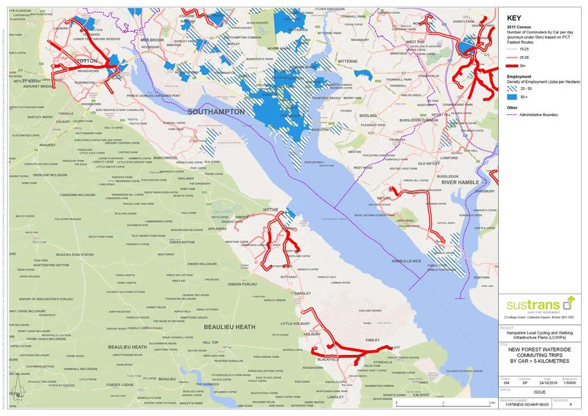
Contents
Introduction.............................................................................. 4   Walking audit (core walking zone)                                                         Route 318:
                                                                                               Existing conditions, barriers to walking                                                  New Road – Frost Lane........................................................... 75
Southampton Waterside LCWIP boundary............................. 7                            and potential options............................................................... 30
                                                                                                                                                                                         Route 319:
Waterside LCWIP network overview....................................... 8                      Totton Town Centre Core Walking Zone................................ 31                   Sizer Way – West Street.......................................................... 77

Hampshire County Council walking and cycling principles... 9                                   Hythe Core Walking Zone...................................................... 36          Table of potential options and cost estimates...................... 79

Department for Transport Local Transport Note 1/20                                             Proposed cycle networks
– Cycle infrastructure design................................................. 10              Existing conditions, barriers to cycling and walking
                                                                                               and potential options............................................................... 38
Low traffic neighbourhoods................................................... 11
                                                                                               Route 320:
Methodology........................................................................... 12      Redbridge Causeway – Ashurst.............................................. 39

Case studies........................................................................... 15     Route 321:
                                                                                               Rushington – Ashurst.............................................................. 43
Sustrans design principles..................................................... 18
                                                                                               Route 322:
Mapping data                                                                                   West Totton – Redbridge Flyover............................................ 45
Traffic Flows, Current network and key destinations.............. 19
                                                                                               Route 323:
Major traffic routes................................................................. 20       A36 – Coriander Drive............................................................. 48

Existing transport network..................................................... 21             Route 324:
                                                                                               Calmore Drive – Coriander Drive............................................. 50
Trip generators....................................................................... 22
                                                                                               Route 260:
Propensity to cycle tool data................................................. 23              Calmore – Langley................................................................... 54

PCT commute data................................................................ 24            Route 256:
                                                                                               Long Lane – Calshot Activities Centre.................................... 63
PCT school data..................................................................... 26
                                                                                               Route 257:
PCT short car trips................................................................. 28        Veal’s Lane – Fawley Road via Hythe...................................... 65

Proposed cycle network........................................................ 29              Route 258:
                                                                                               Coriander Drive – Marchwood Road....................................... 68

                                                                                               Route 259:
                                                                                               South Calmore – Hounsdown................................................. 71

                                                                                                                                                                                                                                                                                New Forest Waterside LCWIP May 2021   4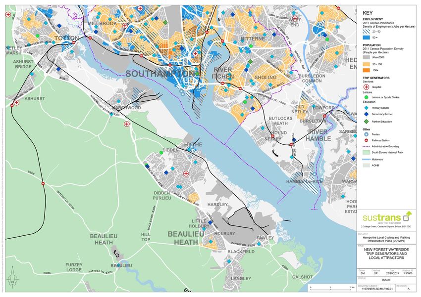
Introduction                                                       It is supported by policies developed and delivered by              shown that pedestrians and cyclists spend more than drivers       Three transport corridors will receive funding:
                                                                   Hampshire County Council including; Local Transport Plan 3,         in local shops per month, through multiple visits; and that
In both Hampshire and New Forest District there is a desire to     the emerging Local Transport Plan 4, and Hampshire’s walking        traders frequently overestimate access by car (ref 4). Walking    Funded corridors are:
invest in sustainable transport measures, including walking and    and cycling strategies which:                                       and cycling schemes frequently achieve better value for money
cycling infrastructure, principally in urban areas, to provide a                                                                       than schemes aimed at relieving congestion, and have wider             1. Waterside (Southampton via Totton, Eling to Holbury)
healthy alternative to the car for local short journeys to work,   • provide a clear statement on Hampshire County Council’s           benefits such as improved public health, air quality, reduced          4. Southampton, via Portswood to Eastleigh
local services or schools; and work with health authorities to       aspirations to support walking and cycling in the short,          community severance and congestion relief (ref 5).                     5. Southampton via Woolston/Bitterne to Bursledon
ensure that transport policy supports local ambitions for health     medium and long term;
and well-being. In doing so, all residents of the Waterside        • provide a framework for support of local walking and cycling      This new LCWIP has been developed alongside a second              This would include transforming public transport connections
area of New Forest District will experience benefits, such           strategies;                                                       bid to the Government’s Transforming Cities Fund for the          and interchange between various modes, in continuing to
as: reduction in air pollution, fewer delays and decreasing        • provide a means of prioritising Hampshire County Council’s        Southampton and New Forest District Waterside area.               deliver the Southampton Cycle Network, making the city centre
frequency of accidents on the highway and improving                  funding to the best value walking and cycling investments, and;                                                                     a better place to live, and using smart infrastructure to make
accessibility for people of all ages and ability.                  • support Hampshire County Council in realising funding             A first, joint bid between Hampshire County Council and           people’s journeys to work more reliable.
                                                                     opportunities for walking and cycling measures.                   Southampton City Council has already secured £5.7m in the
The Waterside peninsula is positioned between the New                                                                                  first round of funding announcements from the Department          Description of Waterside
Forest National Park to the west, a major site of international    The aims of the respective, county-wide strategies are:             for Transport.
importance for nature conservation and the Solent/                                                                                                                                                       The Waterside area of the New Forest District is a long
Southampton Water to the east. This makes the Waterside an         • walking: By 2025, walking will be the travel mode of choice       The TCF funding will accelerate plans to make it easier and       peninsula type area. The New Forest District has a population
environmentally sensitive area, with a number of International       for short trips and the most popular and accessible means         safer for people to cycle by completing three Cycle Freeways      of just over 176,000, with the Waterside area having a
Natural Conservation Designations contained within it.               of recreation;                                                    across Southampton and the wider City Region in Hampshire. It     population of with a population of around 64,000. At just over
                                                                   • cycling: By 2025, cycling will be a convenient, safe, healthy,    has also helped fund innovative new technology to help people     5,000ha in size, it is bounded to the east by Southampton
What is an LCWIP?                                                    affordable and popular means of transportation and                have reliable journeys particularly when travelling by bus.       Water, the south by The Solent and the west by New Forest
                                                                     recreation within Hampshire.                                                                                                        National Park. Consequently, north-south movements
Local Cycling and Walking Infrastructure Plans (LCWIPs), as                                                                            Three major cycle corridors in the Southampton Region             predominate, with notable commuter movements towards
set out in the Government’s Cycling and Walking Investment         Why do we want an LCWIP for the Waterside                           totalling £4.437m have been or are underway to be delivered,      Totton and the city of Southampton.
Strategy, are a new, strategic approach to identifying cycling     area of New Forest District?                                        this includes:
and walking improvements required at the local level. They                                                                                                                                               The Waterside railway line runs as a branch line from Totton.
enable a long-term approach to developing local cycling and        In June 2019, Hampshire County Council declared a Climate           • the SCN1 Western Cycle Route between the city centre, the       Closed to passengers it now carries freight only, to and
walking networks, ideally over a 10-year period, and form a        Emergency, joining more than 70 local authorities across the          Port, Totton and the New Forest (within New Forest District);   from the Marchwood Industrial Park and Military Port. From
vital part of the Government’s strategy to increase the number     country in committing to put environmental issues at the heart      • the SCN3 Eastern Cycle Route from the city centre to            Marchwood the line does continue down to the Fawley Oil
of trips made on foot or by cycle.                                 of everything it does. With around a third of carbon emissions        Bitterne and Bursledon along the A3024 Bursledon Road;          Refinery, however this section has since been decommissioned
                                                                   in Great Britain coming from road transport (ref 1), this report                                                                      and is not currently in use.
Local policies                                                     supports important mitigation and adaptation to climate             The remaining £1.26m will go towards, improving people’s bus
                                                                   change, including targets for carbon neutrality.                    journey time and reliability in the TCF region.                   The town of Totton sits at the northern end of Waterside and
The key outputs of LCWIPs are:                                                                                                                                                                           is connected to Southampton via the Redbridge Causeway,
                                                                   Transformative walking and cycling improvement programmes           The second bid was submitted in Nov 2019. In March 2020,          a major link across the River Test. The area offers several
• a network plan for walking and cycling which identifies          in other parts of the country, are helping to build healthy and     as part of the 2020 Budget, the Chancellor announced £57m         routes into the New Forest National Park as well as coastal
  preferred routes and core zones for further development;         friendly neighbourhoods. In this regard, the plan will help us      funding for the Southampton-Hampshire bid, to be spent            destinations such as Calshot beach and Lepe Beach and
• a prioritised programme of infrastructure improvements for       to achieve our duty to improve both the physical and mental         by March 2023. The outcome of this successful funding bid         Country Park (situated in the New Forest National Park).
  future investment;                                               health of our residents. It will support the aims of our public     included a mix of Bus and ITS measures, Cycle routes to
• a report which sets out the underlying analysis carried          health strategies by making local places healthy and safe (ref      complete the wider Southampton network and a total of six         Settlements in the area include Totton and Eling, Marchwood,
  out and provides a narrative which supports the identified       2), and building physical activity into daily routines (ref 3).     Mobility Hubs and Active Travel Zones (ATZs).                     Dibden and Hythe, Dibden Purlieu, Holbury, Fawley, Blackfield
  improvements and network.                                                                                                                                                                              and Langley and Calshot. The Fawley Oil Refinery is located
                                                                   Walking and cycling are good for the economy. Whilst it might                                                                         towards the southern end of the peninsula and is largest oil
                                                                   be harder to do a weekly shop without a car, studies have                                                                             refinery in the UK. A decommissioned power station site sits

                                                                                                                                                                                                                                      New Forest Waterside LCWIP May 2021   5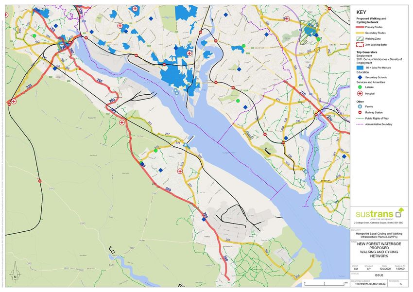
Introduction

      adjacent to the refinery has outline planning permission for       Local trip generators                                              Forest National Park, ending at Lyndhurst. NCN 2 forms a much      promoted by ensuring all development has safe and convenient
      up to 1,500 new homes and 102,600 square metres of new                                                                                longer route along the south coast, linking Dover in Kent to St    links to existing and proposed pedestrian and cycle routes
      commercial, civic and employment space.                            Totton is the largest town in the waterside area offering some     Austell in Cornwall. The section of NCN2 crossing the Waterside    including those on adjacent developments.
                                                                         employment and local shops and facilities (library, health care    area does so via the Hythe Ferry connection from Southampton,
      Transport                                                          centre and community centre) as well at the nearest railway        where it continues east-west through Hythe and Dibden and into
                                                                         station and changes for bus services. The second largest           the New Forest National Park towards Brockenhurst. (NCN2 is
      The A326 is the main route through the area, offering a            settlement is Hythe, where the Hythe ferry can be accessed.        currently rerouted whilst the Hythe ferry isn’t operational).
      connection from junction 2 of the M27, just north of Totton. The
      M27 offers wider links to the M3 to the east and the A31 to the    The Fawley Oil Refinery is a major employer in the Waterside       Developments and opportunities
      west; a major route through the New Forest towards Ringwood        area, with an estimated 2,300 people employed at the site.
      and Bournemouth.                                                   Other key trip generators include the Marchwood Military Port      Hampshire County Council released The Waterside Interim
                                                                         and Marchwood Industrial Park, the New Forest National Park        Transport Strategy in 2017 which was an interim transport
      The A326 takes the form of a single and dual-carriageway (in       and coastal areas, (including Calshot Beach and Lepe Country       policy that set out the County Council’s emerging view on
      parts) bypass style road that runs north to south connecting       Park) local educational and healthcare facilities.                 transport infrastructure requirements for the Waterside area
      Totton to Fawley, although some sections change into                                                                                  in light of potential future growth. The aim of this policy was
      single carriageway in parts. There are several roundabout          New residential development at Marchwood and the former            to support the Local Planning Authorities in the New Forest in
      junctions along the route that serve the settlements of Totton,    power station development will become a future trip generator      developing their Local Plans and to aid planning for strong and
      Applemore, Hythe, Dibden Purlieu and Fawley.                       for housing and employment together with the proposed              sustainable economic and housing growth in the area.
                                                                         Marchwood Port expansion.
      Totton is bound to the east by the River Test with the only                                                                           Hampshire County Council are currently working on a Multi
      access along its eastern side being via the A35 Redbridge          Walking and cycling in the Waterside area                          Modal Waterside Transport Strategy which will be the subject
      Causeway. This is a major connection from the City of                                                                                 of consultation in spring 2021. This Strategy will replace the
      Southampton and very popular with pedestrian and cyclists,         Trips under 2km from the larger local areas are walkable for       interim study of 2017.
      up to 500 cyclists daily, however it is heavily used with more     most people within around 30 minutes. However, in more rural
      than 60,000 vehicles per day. Also this connection offers          village locations they are not, with some network segregation      The Local Plan Examination has been completed and the
      access to the M271 link to junction 3 of the M27.                  evident between village settlements.                               New Forest District’s Local Plan 2016-2036 Part 1: Planning
                                                                                                                                            Strategy was adopted on 6 July 2020. The plan will provide for
      There is a train station at Totton, with services to,              For the whole of the New Forest District the 2011 Census           5,000 new dwellings, up to 2036 and around 83,000 square
      Brockenhurst, Bournemouth and Poole, and Weymouth, to the          reported that, around 15% of commuting trips are under 2km.        metres of employment land (including 40,000 square metres at
      west and Southampton Central to the east, which offers links       Of these around 56% are driven, and 32% are on foot.               Fawley Waterside).
      to London and other east coast services. There are a number
      of bus services which provide public transport within the          27% of commuting trips made by New Forest District residents       This includes a major development site at the former Fawley
      Waterside area, and services to nearby towns and cities. The       are under 5km, a distance that can easily be cycled in around      Power Station site that would potentially see the construction
      Hythe Ferry offers the only passenger link across Southampton      20-30 minutes. 68% of these short trips are currently made by      of up to 1,500 new homes and 102,600 square metres of new
      Water. However at the time of this LCWP being produced this        car or van and only 9% by bicycle.                                 commercial, civic and employment space. Land south of Bury
      ferry service is closed and remains so further notice.                                                                                Road, at Marchwood, is allocated for residential development
                                                                         42% of children walk to school in the New Forest District and      for up to 700 new homes and public open space, and Land to
                                                                         4% cycle. Around 37% travel by car. Cycling to secondary           the north of Totton is allocated for residential-led mixed use
                                                                         schools and colleges is more common (7%) than cycling to           development and open space, comprising of up to 1,000 new
                                                                         primary school (2%).                                               homes, business and employment use, a primary school and
                                                                                                                                            public open space.                                                 1:	https://assets.publishing.service.gov.uk/government/uploads/system/uploads/attachment_data/

                                                                         Two National Cycle Network routes pass through the Waterside                                                                              file/790626/2018-provisional-emissions-statistics-report.pdf
                                                                                                                                                                                                               2:	https://documents.hants.gov.uk/public-health/
                                                                         area: NCN236 and NCN2. NCN236 originates at Ocean Village          Their local plan seeks to encourage and enable more                    TowardsahealthierHampshireastrategyforimprovingthepublicshealth2016-2021.pdf
                                                                                                                                                                                                               3:	https://documents.hants.gov.uk/public-health/HampshirePhysicalActivityStrategy2018-21.pdf
                                                                         in Southampton, connecting from NCN2 and NCN23 and travels         sustainable means of travel including walking and cycling, to      4:	https://www.livingstreets.org.uk/media/3890/pedestrian-pound-2018.pdf
                                                                                                                                                                                                               5:	https://assets.publishing.service.gov.uk/government/uploads/system/uploads/attachment_data/file/416826/
                                                                         along the southside of Southampton, past Totton and into the New   reduce reliance on private vehicles. Walking and cycling will be       cycling-and-walking-business-case-summary.pdf

                                                                                                                                                                                                                                                              New Forest Waterside LCWIP May 2021                            6
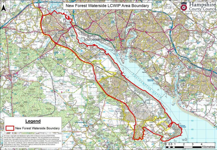
New Forest Waterside
LCWIP Boundary

                       New Forest Waterside LCWIP May 2021   7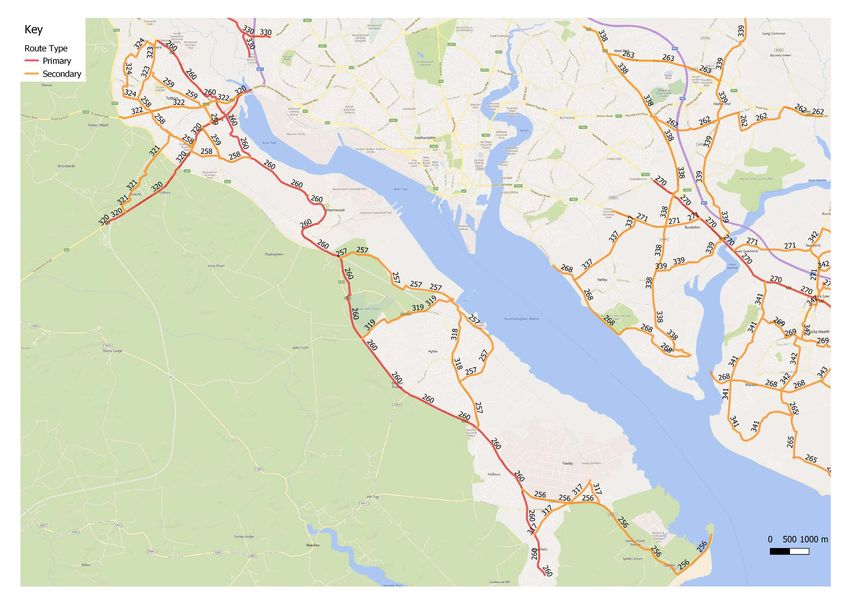
Waterside LCWIP                                 323
                                  324
network overview
                                               Pages 48-49

                                 Pages 50-53                                       260                                                                 This map represents an overview of the Waterside area,
                                                  259
                                                 Pages 71-74
                                                                                  Pages 54-62
                                                                                                                                                       and the proposed cycle network.

                                                  Totton                                                                                               Each route has been assigned a three-digit reference
                                                                                                                                                       number and dived up into two categories of routes -
                                  322
                                 Pages 45-47
                                                                                                                                                       ‘primary’ which represent busy, direct, and main routes
                                                                                                                                                       and ‘secondary’ which represent medium usage routes
                                                                                                                                                       through local areas, feeding into the primary routes.

                    321                                             258                                                                                Click on the page number box (below the route reference
                   Pages 43-44
                                                                   Pages 68-70                                                                         number) to view that specific area in more detail.

                                                                                 Marchwood

                                                                320
                                                               Pages 39-42

                                                                                                 319
                                                                                                Pages 77-78
                                                                                                                                Southampton
                                                                                                                                   Water

                                                                                                          Hythe

                                                                                                                   318
                                                                                                                  Pages 75-76

                                                                                                     257
                                                                                                   Pages 65-67

                                                                                                                                              Fawley

                                                                                                                                 256
                                                                                                                                Pages 63-64

                                                                                                                                                                                   New Forest Waterside LCWIP May 2021   8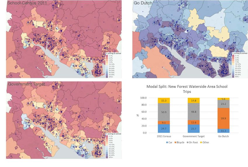
Hampshire County                                                   Overarching principles                                              Hampshire walking and cycling strategies                          It should be noted that since both the Strategies have been

Council walking and
                                                                                                                                                                                                         adopted, national policy and guidance on active travel
                                                                   1. Prioritise walking and cycling for healthier people, healthier   Hampshire covers a geographically diverse landscape with          has moved forward, particularly with the Government’s

cycling principles
                                                                      transport, and a healthier planet.                               distinct localities. The existing cycle network in Hampshire      publication of its Walking and Cycling Investment Strategy in
                                                                                                                                       provides over 750 miles of off-road and urban cycle paths         2017 (the origin on LCWIPs), and more recently with the new
                                                                   2. Have an integrated approach to all aspects of planning,          which along with an extensive network of footways and a 2,800     Gear Change Policy and Local Transport Note 1/20.
Together with movements in national policy and guidance               development, design, and operation.                              mile rights of way network, offering a wealth of walking and
Hampshire County Council has developed new draft principles                                                                            cycling opportunities.
for walking and cycling as part of the development of a            3. Ensure our planning is network based, shaped by evidence,
new Local Transport Plan. These new principles have been              and monitored.                                                   In 2015 Hampshire County Council adopted its first Cycling
designed to:                                                                                                                           Strategy, followed in early 2016 by the adoption of its first
                                                                   Planning                                                            Walking Strategy. Both strategies provided a clear statement of
• enable more people to walk, cycle or use public transport in                                                                         Hampshire County Council’s aspirations for walking and cycling.
  scale with our Climate Emergency;                                4. Engage a wide range of users, and potential users, in the
• deliver better environments to match our 2050 Vision, both          design process.                                                  The strategies aimed to:
  in towns and in the countryside;
• deliver better transport for all;                                5. Reframe the potential for walking, cycling and public            • set a strategic framework to support the planning and
• play our part in addressing the factors that contribute to          transport to work together for longer distance journeys.           development of cycling measures with local partners and
  public health including social disparities;                                                                                            support the development of local walking strategies;
• reduce social inequalities and exclusion by improving the        6. Trial new things, and if they do not work, we’ll change them.    • provide a means to prioritise funding for cycling to the best
  ability for everyone to access destinations including work,                                                                            value for money investments for active travel modes;
  education, visiting friends and family, shopping, and leisure,   Design and implementation                                           • help support the County Council in attracting and realising
  without reliance on private cars.                                                                                                      additional funding opportunities for active and sustainable
                                                                   7. Focus street design on people.                                     transport measures.
Hampshire County Council have developed 10 walking
and cycling principles, reviewing best practice, and giving        8. Incorporate national design principles into every transport      This LCWIP seeks to build on these established Walking and
consideration to: aspirations, movement, place, maintenance           scheme. Our designs will be:                                     Cycling Strategies, which operated at a broader and higher
and engagement.                                                                                                                        level, to address active travel modes, countywide.
                                                                      •   safe;
These principles have all been established via County Council         •   coherent;                                                    LCWIPs allow a more detailed and local level focus,
Member and Officer steering groups and consulted widely               •   direct;                                                      concentrating on strategic network improvements that aim to
through these groups.                                                 •   comfortable;                                                 help connect people directly, safely and conveniently.
                                                                      •   attractive;
They were presented at Hampshire County Council’s first ever          •   adaptable and;                                               For further information on the Hampshire County Council
Active Places Summit (October 2020) to engage with a wide             •   accessible to all.                                           Walking and Cycling Strategies please follow this link –
range of people who use our streets, high streets, walking and
cycle routes on a day-to-day basis.                                9. Deliver walking and cycling environments that feel               https://www.hants.gov.uk/transport/strategies/
                                                                      comfortable and provide inclusive access for everyone            transportstrategies
The principles sit under three headings:                              regardless of confidence, age and disability.

• Overarching principles;                                          10. Design the right scheme for each location.
• Planning;
• Design and implementation.                                       These principles, when applied, will help reinforce Hampshire
                                                                   County Council’s goals in delivering a healthy, sustainable, and
                                                                   active county, well into the future.

                                                                                                                                                                                                                                    New Forest Waterside LCWIP May 2021   9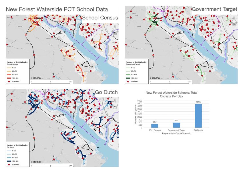
Department for                                                                                                                       Cycle parking would be considered as part of relevant schemes      Wayfinding

Transport Local
                                                                  When reading this LCWIP, keep in mind that the huge                and is something that is also being considered as part of
                                                                  amount of work undertaken in its production was                    Hampshire’s developing Local Transport Plan 4 (LTP4).              Wayfinding refers to information systems that guide

Transport Note 1/20
                                                                  completed before the publication of LTN 1/20. Whilst                                                                                  people through a physical environment and enhance their
                                                                  we are confident that our approach to network planning             Some examples of best practice cycle parking are provided below:   understanding and experience of the space.

– Cycle infrastructure
                                                                  aligns with this new guidance, some of the high-level
                                                                  suggestions will need further development. Any future                                                                                 Wayfinding is particularly important in complex built

design
                                                                  scheme will be designed to comply with LTN1/20 and                                                                                    environments such as urban centres, long distance trails, and
                                                                  will be developed in line with our new walking and                                                                                    transportation facilities.
                                                                  cycling principles.
The publication of the LTN 1/20 in July 2020 followed the                                                                                                                                               As environments become more complicated, people need
Government’s announcement for new investment provided                                                                                                                                                   visual cues such as maps, directions, and symbols to help
towards cycle improvements, across the country.                For the full information on these documents please see:                                                                                  guide them to their destinations. In these often high-stress
                                                                                                                                                                                                        environments, effective wayfinding systems contribute to a
Local Authorities and developers are now expected to use LTN   Link to DfT’s Gear change: a bold vision for cycling and walking:                                                                        sense of well-being, safety, and security.
1/20 in the design of their schemes.                           Cycling and walking plan for England - GOV.UK (www.gov.uk)
                                                                                                                                      An example of on street lockable cycle ‘hangar’ style             The new LTN 1/20 states that:
                                                                                                                                      parking facilities – Waltham Forest, London
The key principles that underpin LTN 1/20 are1:                Link to DfT’s Cycle infrastructure design (LTN 1/20) guidance:
                                                               https://www.gov.uk/government/publications/cycle-                                                                                        There is a balance to be struck between providing enough
• cyclists must be separated from volume traffic, both at      infrastructure-design-ltn-120                                                                                                            signs for people to be able to understand and follow cycle
  junctions and on the stretches of road between them;                                                                                                                                                  infrastructure and ensuring that the signs themselves do not
• cyclists must be separated from pedestrians;                 Cycle parking                                                                                                                            create confusion or street clutter. Routes on other rights of way
• cyclists must be treated as vehicles, not pedestrians;                                                                                                                                                not on the highway can use customised waymarking.
• routes must join together; isolated stretches of good        Cycle parking is integral to any cycle network, and to wider
  provision are of little value;                               transport systems incorporating public transport.                                                                                        Hampshire County Council would include wayfinding as part of
• routes must be direct, logical and be intuitively                                                                                                                                                     our network planning in all schemes, in line with LTN1/20.
  understandable by all road users;                            The availability of secure cycle parking at home, the end of a
• routes and schemes must take account of how users            trip or at an interchange point has a significant influence on
  actually behave;                                             cycle use.
• purely cosmetic alterations should be avoided;                                                                                      An example of cycle hub parking facilities
                                                                                                                                      – Winchester Train Station
• barriers, such as chicane barriers and dismount signs,       The new LTN 1/20 states that:
  should be avoided;
• routes should be designed only by those who have             Cycle parking is an essential component of cycle infrastructure.
  experienced the road on a cycle.                             Sufficient and convenient residential cycle parking enables
                                                               people to choose cycling. At the trip end, proximity to
                                                               destinations is important for short stay parking, while for longer-
                                                               stay parking security concerns can be a factor. As with other
                                                               infrastructure, designers should consider access for all cycles
                                                               and their passengers.

                                                                                                                                                                                                        1:	Summary taken from DfT’s Gear Change. A bold vision for cycling and walking.

                                                                                                                                                                                                                                                        New Forest Waterside LCWIP May 2021   10
Low traffic In a recent case study*, LTNs resulted inan increase in children “Recent research showed that more people in Waltham Forest
neighbourhoods
playing outside, lower air pollution, together with making walking are cycling. In our 2016 resident insight survey, 17% (approx.
and cycling more of a natural choice for everyday local journeys. 46,100 people) said they cycle, compared to 12% (approx.
32,500 people) the year before – and two-thirds (73%) said they
Low traffic neighbourhoods, or LTNs, are often described Furthermore, it was reported that LTNs did not add significantly cycle at least once a week, up from 62% in 2015”.
as ‘cells’ of residential streets bordered by main roads. Within to congestion on main roads.
these cells, access is maintained for residents, deliveries and *Source: https://www.enjoywalthamforest.co.uk/
emergency vehicles, but motor vehicle “through” traffic is Modal filters (also known as point closures) can take the form
discouraged or in some cases removed. of many things from planters to bollards or even cycle stands, The Waltham Forest scheme cost £27m and was funded in
that can also act as handy cycle parking. 2013 by the Mayor of London’s Mini-Hollands fund.
Through-traffic or rat-running can have a serious impact on Northcote Road, Walthamstow – Modal filter with wooden
bollards, planting, and cycle parking
the health and quality of life of the people living on a street, LTNs can also include making routes one-way, allowing Hampshire’s approach to Low traffic neighbourhoods
and impact disproportionately on more deprived communities. footways to be widened, creating seating areas outside local
Noise and air pollution, and speed and volume of traffic are businesses, and restricting access to motor traffic during Low Traffic Neighbourhoods will be included in the forthcoming
often sighted as issues that effects peoples’ enjoyment of certain times. engagement on Hampshire’s emerging Local Transport Plan 4.
spending time on their own streets.
“The first low traffic neighbourhood in Waltham Forest’s mini- Hampshire County Council is open to hearing from local
Low traffic neighbourhoods can create an improved Holland saw motor traffic levels fall by over half inside the communities who might like to develop or trial one of
environment, get neighbours talking, and even see a return of residential area and by 16% even when including the main Hampshire’s first low traffic neighbourhoods in their area.
children playing in the street. Quieter and safer-feeling streets roads. Motor traffic levels went down by over 5% on the main
can support a switch to more healthy, active ways of travelling road nearest the second scheme”. We recognise that there are many challenges to introducing
around, particularly for shorter journeys to local amenities. Low Traffic Neighbourhoods, however, examples from across
Source: Living Streets London have proved they can work and once settled in, are
Residents, visitors, or delivery drivers needing to reach Francis Road, Leyton – Time restrictions on through very popular.
anywhere within the low traffic neighbourhood would still be In 2018, Hampshire County Council officers attended a guided motorised traffic, footway widening and bollards to allow
for seating areas
able to do so by car – though they might have to approach visit to the country’s flagship Low Traffic Neighbourhood in the
from a different direction. London Borough of Waltham Forest. The photos below show
what was achieved there:
Orford Road, Walthamstow Village – Footway widening,
cycle parking stands and one-way traffic flow with time
restrictions on motorised traffic (except buses)
New Forest Waterside LCWIP May 2021 11Methodology • a report which sets out the underlying analysis carried Gathering information schools, shopping areas, hospitals, leisure or sports centres.
out and provides a narrative which supports the identified Future development sites such as draft local plan allocations
Sustrans was commissioned by Hampshire County Council improvements and network. Comprehensive information and data sources were provided by give an indication of potential future transport demand.
(Hampshire County Council) in July 2019 to support the Hampshire County Council and NFDC which was augmented
development of Local Cycling and Walking Infrastructure Plans This draft consultation report addresses the first and third by publicly available datasets from the 2011 Census (e.g. There is a significant concentration of trip generators in the
(LCWIPs) in six areas (Fareham, Gosport, Havant, Eastleigh, outputs, but further work will be needed for the second output, population and employment), DfT Traffic Counts, Road Traffic larger town centre areas, especially retail and employment,
Southern Test Valley and New Forest Waterside) to support including feedback from the current consultation. Collisions, schools, public amenities and previous consultation but there are also large employment sites contained within the
two separate bids to the DfT’s Transforming Cities Fund. These plans exploring existing and new networks. Review and Waterside peninsula. Secondary schools are dispersed across
LCWIPs have been co-developed by both organisations. The LCWIP process has six stages as set out below: analysis of the data was undertaken using a bespoke online the whole area. Leisure and sports centres are also dispersed
Sustrans were engaged for their particular expertise in: map created on Sustrans Earthlight platform. The main trip across the whole area.
1. Determining scope generators were identified and an initial network mapped out to
• identifying new and improved walking and cycling routes for Establish the geographical extent of the LCWIP, and link residential areas with these locations. Population densities are generally higher in central areas and
prioritisation; arrangements for governing and preparing the plan. more dispersed further out, which suggests that short trips are
• aligning with key Council policies and programmes that A stakeholder workshop was held at an early stage of the likely to be concentrated in these central areas. However, all
support local economic growth, improvements to health and 2. Gathering information process (27 September 2019) to test assumptions and to residential areas are within 5km of many major destinations,
well-being and the environment; Identify existing patterns of walking and cycling and gather useful information from local stakeholder groups. They providing a strong argument in favour of a comprehensive
• engaging key local stakeholders. potential new journeys. Review existing conditions and were asked to identify barriers to walking and cycling, including walking and cycling network across the whole urban area.
identify barriers to cycling and walking. Review related crossing points of the main barriers (roads, railways, rivers),
The scope of the work was limited to utility trips to work, transport and land use policies and programmes. which form the nodes in the network. Large blank maps were Propensity to cycle data
education and shopping of up to 5km. It does not include provided for people to draw on, as well as background maps of
consideration of leisure trips outside the urban areas. Survey 3. Network planning for cycling the local transport network with information on trip generators The cycle commute map for Waterside based on census
work was undertaken by both Sustrans and Hampshire County Identify origin and destination points and cycle flows. from the Sustrans GIS database. 2011 flow data indicates that Fawley, Hythe and Dibden are
Council staff. Convert flows into a network of routes and determine the important destinations, with strong flows connecting the three
type of improvements required. Existing walking and cycling network settlements. There are also significant flows in Totton. It should
The approach was to look afresh at opportunities to create be noted that commuting is only 14% of all trips nationally.
walking and cycling networks. Existing facilities and routes 4. Network planning for walking The main existing routes comprise National Cycle Network
were considered, along with known improvement proposals. Identify key trip generators, core walking zones and (NCN) Route 2 along the coast between Brockenhurst and The school travel map shows strong flows in Totton, with
Local stakeholders helped to identify where new routes and routes, audit existing provision and determine the type of Southampton and NCN236 between Lyndhurst and Redbridge. significant flows between Fawley and Dibden. It should be
improvements were needed. The potential routes were then improvements required. There is a number of existing cycle routes of variable quality. noted that education and escort to education is only 13% of all
surveyed on foot and bicycle. The methodology adopted was trips nationally.
informed by the Design Guidance published as part of the 5. Prioritising improvements There is an extensive Rights of Way network, across the
Active Travel (Wales) Act 2013, the London Cycling Design Prioritise improvements to develop a phased programme District. The urban public footpaths are fragmented and do not We have also analysed the short car trips under 5km for
Standards (first published 2005, latest update 2016) guidance for future investment. comprise a comprehensive joined-up walking network, although journeys to work, on the basis that these might reveal the
on developing a coherent cycle network and the LCWIP they will be locally useful for trips on foot. With the exception potential for modal shift towards walking and cycling. These
Technical Guidance (published 2017). 6. Integration and application of the Veal’s Lane footpath, the Rights of Way have limited show strong flows around Totton town centre, Hythe, Dibden
Integrate outputs into local planning and transport policies, potential for cycling, as they do not serve everyday journeys. and Fawley, with weaker flows between the urban centres due
LCWIP technical guidance strategies, and delivery plans. to the distances involved. This map suggests that there is good
Trip generators potential for modal shift across the area.
Under the guidance, the key outputs of LCWIPs are: Stage 1 was determined by Hampshire County Council who will
also lead on Stages 5 and 6 together with New Forest District An important starting point in designing a walking and cycling Commuting, education and escort education trips only account
• a network plan for walking and cycling which identifies Council (NFDC). Sustrans and Hampshire County Council have network is to determine the likely origin and destination points for 27% of all trips in England, so there is a danger that too
preferred routes and core zones for further development; jointly developed Stages 2, 3 & 4. for everyday trips to work, school, shopping and leisure. The trip much weight is given to these types of trip, because the data is
• a prioritised programme of infrastructure improvements for generators map in the following pages gives a visual indication readily available from the Census 2011. Shopping accounts for
future investment; of the destinations, including: employment areas, secondary 18% of all trips and leisure 22% so arguably we should focus
New Forest Waterside LCWIP May 2021 12Methodology
on these trips, but unfortunately there is limited data available. sections of secondary routes may have higher flows than parts Door to door journeys Larger interchanges, such as train station to bus station, should
The full breakdown from the National Travel Survey of English of the primary routes, so the distinction between primary and also have facilities appropriate to usage. If there is shelter
residents published in July 2019 is shown in the table below: secondary should not form the basis of investment priorities. In addition to planning for local trips on foot and by bike, it is from the elements, a safe place to wait and possibly additional
important to ensure that longer distance journeys are made as facilities such as a coffee shop then wait times can seem
Network planning for cycling The proposed network has been visually tested against easy as possible by integrating walking and cycling networks shorter than they actually are. It is also very useful to provide
the Propensity to Cycle data and there is a high degree of with public transport interchanges. real-time information at interchanges.
There is a wealth of information to consider when planning correlation between the two networks, with all the major
a cycle network for Waterside, as described above. Our employment sites and secondary schools served by the The concept of the “door-to-door” journey was introduced by the Where users are not taking a motorised form of transport to
approach was to work through all the data, switching layers on proposed network as shown on the Proposed Network map. Campaign for Better Transport in 2011, leading to the publication access or exit their next mode of transport then interchange is
and off within our GIS mapping system to test the emerging The proposed network also serves the main shopping areas, of a Government door to door strategy in 2013. The emphasis still as important. Cycling facilities needs to be safe and secure
network. The sequence below reflects the series of maps on hospitals, leisure and sports centres and development sites. is on access to public transport interchanges at both ends of and in an accessible place for changing modes quickly. This
the following pages: the journey – perhaps walking or cycling from home to the train is the same for bike hire facilities. Walking and cycling routes
Network planning for walking station, then picking up a hire bike to the final destination. need to be well signed giving distances and potentially times
When considering the number of routes to include in this to key destinations. Provision for taxis, good pedestrian access
plan, we have taken the advice from para. 5.21 of the LCWIP We have assumed that the trip generators for walking are the The government strategy focuses on four areas: and, where appropriate car parking, also need to be made.
Technical Guidance that “it will take time to develop a same as those for cycling, albeit that shorter distances will be
network with a tight density, and wider mesh widths (distance involved (less than 2km as recommended by LCWIP guidance). • accurate, accessible and reliable information about the
between routes) of up to 1000m would be expected within The proposed cycle network provides a suitable framework different transport options for their journeys;
the initial phases of the network’s development”. Further for walking trips, although it is recognised that a much finer- • convenient and affordable tickets, for an entire journey;
routes can be added at a later stage to create a denser grained network is required for walking since most streets • regular and straightforward connections at all stages of the
network, but our advice is to start with fewer routes and have footways. When the cycle network is designed, it will be journey and between different modes of transport;
implement them to a high standard. The proposed network vital to ensure that people on foot do not have a reduced level • safe, comfortable transport facilities.
is denser within the central area, closer to the ideal density of service, for example no existing footways to be converted
of 400m between routes. to shared use without widening. All crossings on the cycle As most public transport journeys involve a mode change,
network must accommodate people on foot and on bikes. interchange between these is very important. Users do not
The primary routes are judged to be the most popular and want to have to go out of their way to access the next mode.
strategic routes, linking residential areas with the key trip Signing also needs to be clear, passengers often have short
generators. Secondary routes can be locally important but are connection times so need reassurance they will be able to
less strategic as they fill the gaps in the primary network. Some locate their next connection within their time frame.
Journey purpose Annual trips % LCWIP ref Map ref Analysis Potential options
Commuting 188 14.16%
5.40 Barriers to movement (traffic flows) Crossing points of major roads New crossings if required
Business 43 3.27%
Education 94 7.04%
4.4 Existing walking and cycling network Quality, value for local journeys Improvements if required
Escort education 80 6.00%
Shopping 245 18.42%
5.9 Trip generators Map all important origins and destinations Ensure the network swerves all major
Other escort 116 8.76% destinations
Personal business 130 9.75%
Visit friends at private home 127 9.58% 4.8 Propensity to Cycle Tool (cycle commute, Existing trips and modelled increases Design network to accommodate the
Visit friends elsewhere 70 5.26% cycle to school and short car trips) major flows
Sport/entertainment 99 7.48%
Holiday/day trip 61 4.57%
Other including just walk 76 5.71% 5.23 Proposed walking and cycling network Test against core design outcomes Improvements if required
All 1,329
New Forest Waterside LCWIP May 2021 13Methodology
Implementation Propensity to cycle scenarios appropriate investment for cycling trips to work, it does not
provide further information on those potential cyclists and their
The inclusion of a route in the network plan is no guarantee The Propensity to Cycle (PCT) is an open source transport personal attributes and behaviours to help design the most
that it will be implemented. While we have made every planning system, part funded by the Department for Transport. effective interventions.
effort to ensure that our proposals are practical, it should be It was designed to assist transport planners and policy makers
recognised that there are competing demands for highway to prioritise investments and interventions to promote cycling. The first map shows current levels of cycling to work, which are
space, including cars, parking, buses, taxis and parking. More information is available from the PCT website: above the UK average in Waterside, the second map shows
Some sections of proposed routes may be on private land https://www.pct.bike/m/?r=hampshire the Government Target scenario which indicates a relatively
and discussions with landowners will be required. Proposed modest increase in cycle commuting. The third map shows the
road space reallocations for walking and cycling will need to The aim of the PCT is to inform planning and investment Go Dutch scenario which indicates that a significant proportion
carefully consider implications across all modes, although decisions for cycling infrastructure by showing the existing and of commuter trips could be made by bike.
the ultimate aim must be to reduce the dominance of motor potential distribution of commuter cycle trips and therefore
vehicles, thereby easing congestion. This report is not a inform which investment locations could represent best value People in the Netherlands make 28.4% of trips by bicycle, fifteen
feasibility study, but a high level assessment. All proposals will for money. PCT uses two key inputs: times higher than the figure of 1.6% in England and Wales,
be subject to further feasibility work and detailed design work where cycling is skewed towards younger men. By contrast
will be necessary. In some cases, this may mean that a route is • Census 2011 Origin and Destination commuting data in the Netherlands cycling remains common into older age,
moved to an alternative parallel alignment. (O-D data); and women are in fact slightly more likely to cycle than men.
• Cycle Streets routing. Whereas the cycle mode share is ‘only’ six times higher in the
If schemes are to be progressed, they will need to be Netherlands than in England for men in their thirties, it is over 20
prioritised for inclusion in delivery programmes alongside other The model estimates cycling potential adjusted for journey times higher for women in their thirties or men in their seventies.
proposals, with schemes subject to the appropriate level of distance and hilliness as well as predicting the likely distribution
business case development. of those trips using the Cycle Streets routing application The Go Dutch scenario represents what would happen if English
(https://www.cyclestreets.net/). and Welsh people were as likely as Dutch people to cycle a trip
It is also intended that this LCWIP would be used to inform of a given distance and level of hilliness. This scenario thereby
developers of the level of ambition for the walking and cycling The model can be applied to consider different scenarios such captures the proportion of commuters that would be expected
network so that they may contribute towards it. as: Gender Equality, where women cycle as frequently as men; to cycle if all areas of England and Wales had the same
Go Dutch, if cycling levels were the same as in the Netherlands; infrastructure and cycling culture as the Netherlands.
Hampshire’s first LCWIP focus is on the routes and zones that and, Government Target, where cycling levels meet the target
have the greatest potential to convert car trips to walking and for current government’s aim for cycling. We have created a series of maps based on data available on
cycling trips. This means they tend to have a more urban focus, the PCT website, which are displayed on the following pages:
where trips are often shorter, and where more people live, work Whilst this model is a useful tool, there are a number of
and visit. limitations which should be considered especially when making • commuter and school travel area data for Waterside,
decisions based on the patterns shown. Firstly, the data only based on the Census 2011, Government target and Go
Hampshire County Council recognises this and will seek to shows travel to work and school trips, only 27% of all journeys; Dutch scenarios;
address the balance for more rural areas, walking zones and travel for shopping and for leisure is not included. Secondly, • commuter route data for Waterside, based on the three
tertiary cycle routes, in future versions of LCWIPs. These future the data also misses out minor stages of multi-stage commuter scenarios;
versions are likely to have closer links to our Public Rights of trips so cycle journeys to train stations and bus stops are not • school route data for Waterside, based on the three
Way network. represented. Lastly the distribution of journeys is a prediction scenarios;
of the likely route taken based on the Cycle Streets routing • commuter short car trips based on Census 2011 data.
algorithm and not the actual route being used.
It is worth noting that whilst the model builds an assessment
of cycling propensity, it does not segment potential users, or
provide any insight into people on foot. Although this model
does provide planners with an overview to identify areas for
New Forest Waterside LCWIP May 2021 14Case studies Southampton City Council completed work on Bevois Valley, in Bike Life
October 2020, creating the first stages of the SCN6 cycle route
In addition to the Government’s Cycling and Walking from the city centre to Portswood and Eastleigh. Sustrans 2017 Bike Life report is the UK’s biggest assessment
Investment Strategy, a number of local authorities and of cycling in seven major cities: Belfast, Bristol, Edinburgh,
devolved administrations have published their own strategies Improvements along Onslow Road and Bevois Valley Road Birmingham, Cardiff, Greater Manchester and Newcastle.
for increasing levels of walking and cycling and some of these include:
are summarised below, together with a few practical examples. Bike Life is inspired by the Copenhagen Bicycle Account (a
Widened shared use footways and new crossing facilities to biennial summary of key statistics on cycling in Copenhagen)
Southampton Cycle Network enhance access for people walking and cycling. and is an analysis of city cycling development including
infrastructure, travel behaviour, satisfaction, the impact of
The Southampton Cycle Network (SCN) is Southampton City • Continuous crossings to prioritise people walking and cycling and new initiatives. The information in the report
Council’s statement for Southampton having a safe, integrated, cycling across junctions. comes from local cycling data, modelling and a representative
and easy to use network of cycle facilities that is usable by • Upgraded signage. survey of over 1,100 residents in each city conducted by ICM
everybody. Providing people with a choice of routes including • Resurfacing. Unlimited, social research experts. There is widespread public
a series of high quality safe routes that radiate out from the city • New toucan crossings at the junction with Mount Pleasant support for creating dedicated space for cycling, as shown in
centre and goes across the city, along with a network of quieter Road, creating new convenient crossing points for people the infographics below.
routes, open spaces, off-road paths and waterside routes. walking and cycling.
• Changes to the bus stop between Bevois Valley Road Car Summary of Bike Life survey data
The SCN hierarchy of strategic, local and leisure routes has Park and Ancasta Road, enabling two buses to pull up at
been devised acknowledging that people will want to choose raised kerbs and allowing buses to pull out with greater ease.
different routes for different purposes. The current network
of cycle facilities in Southampton totals 41.3 miles (66.6km).
This includes National Cycle Network (NCN) routes, commuter
routes, leisure routes across Southampton Common, along the
River Itchen and other open spaces, quieter routes along back
streets, and local routes.
The SCN3 Eastern Cycle Freeway is part of the Southampton
The network extends outside of Southampton connecting Cycle Network (SCN). It provides a new segregated, shared
with the surrounding towns and villages of Totton, Romsey, route to help more people in the east of the city and Hampshire
Chandlers Ford, Hedge End and into the Hamble Peninsula. cycle safely and with confidence. The route includes a new
2.6km segregated cycle freeway along Bursledon Road from
Windhover Roundabout as well as priority for people cycling
over side crossings and improved crossing points. At Bitterne
SCN6 – Bevois Valley Road, Southampton
village, the route connects to the SCN4 which provides a
network of ‘quiet ways’ through Bitterne to Northam Road.
More information about the SCN can be found within
Southampton City Council’s Cycle Southampton: A Strategy for
our City 2017-2027 cycling-southampton-2017-2027-final.pdf
and on the My Journey website –
https://myjourneysouthampton.com/cycle/get-cycling/
southampton-cycle-network
New Forest Waterside LCWIP May 2021 15You can also read