Longterm study of hydrothermalism and biology at the Logatchev field, Mid-Atlantic Ridge at 14 45'N (revisit 2005; HYDROMAR II)
←
→
Page content transcription
If your browser does not render page correctly, please read the page content below
Meteor Berichte 05

                          Mid-Atlantic Expedition 2005

                              Cruise No. 64, Leg 2

Longterm study of hydrothermalism and biology
  at the Logatchev field, Mid-Atlantic Ridge at
     14°45’N (revisit 2005; HYDROMAR II)
             6 May – 6 June 2005, Fortaleza (Brazil) – Dakar (Senegal)

K.S. Lackschewitz, M. Armini, N. Augustin, N. Dubilier, D. Edge, G. Engemann, M.
Fabian, J. Felden, P. Franke, A. Gärtner, D. Garbe-Schönberg, H.-H. Gennerich, D.
Hüttig, H. Marbler, A. Meyerdierks, T. Pape, M. Perner, M. Reuter, G. Ruhland, K.
Schmidt, T. Schott, M. Schroeder, G. Schroll, C. Seiter, J. Stecher, H. Strauss, M.
Viehweger, S. Weber, F. Wenzhöfer, F. Zielinski

                          Project Leader: Heiner Villinger

                                   Leitstelle Meteor
                 Institut für Meereskunde der Universität Hamburg

                                       2005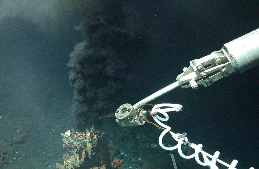
Content
SUMMARY..................................................................................................................................................... 1

    2.1         PARTICIPANTS ................................................................................................................................. 2
    2.2         RESEARCH PROGRAM ...................................................................................................................... 4
    2.3         NARRATIVE OF THE CRUISE .............................................................................................................. 5
    2.4         PRELIMINARY RESULTS ................................................................................................................... 9
        2.4.1       Detailed geological studies of the Logatchev-1 hydrothermal field.............................................. 9
        2.4.2       ROV deployments..................................................................................................................... 12
        2.4.3       OFOS deployments .................................................................................................................. 14
        2.4.4       Description of rocks and hydrothermal precipitates .................................................................. 17
        2.4.5       Environmental parameters and longterm monitoring ................................................................ 19
        2.4.6       Physico-chemical characterization of the Logatchev hydrothermal field (LHF) ......................... 26
        2.4.7       Fluid chemistry ........................................................................................................................ 33
        2.4.8       Marine microbiology................................................................................................................ 42
        2.4.9       Hydrothermal symbioses .......................................................................................................... 45
        2.4.10       Fluid dynamic and microbial processes.................................................................................... 48
        2.4.11       Metagenomics.......................................................................................................................... 51
        2.4.12       Marine zoology........................................................................................................................ 53
    2.5         WEATHER CONDITIONS .................................................................................................................. 60
    2.6         ACKNOWLEDGMENTS .................................................................................................................... 60
    2.7         REFERENCES ................................................................................................................................. 61
APPENDIX                                                                                                                                                    62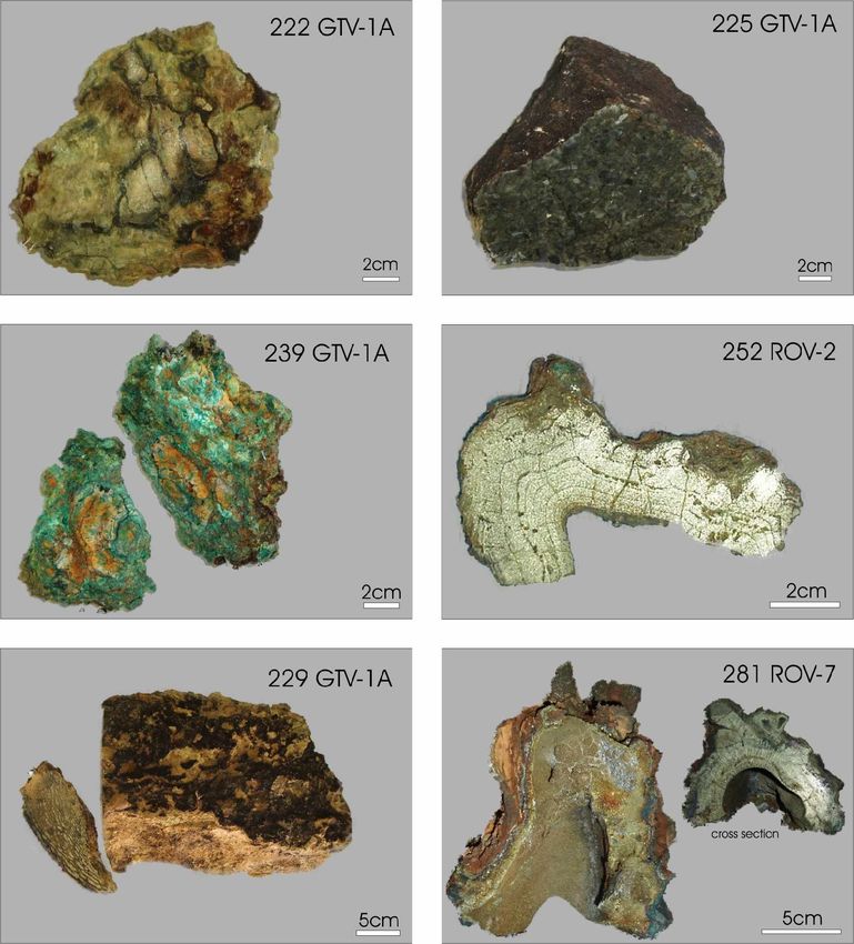
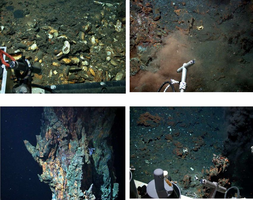
Summary                                                                                    1

Summary

The R/V METEOR cruise M64/2 was the second German expedition to the hydrothermal
active Logatchev field at 14°45’N which took place from May 6 through June 6, 2005 from
Fortaleza/Brasil to Dakar/Senegal.
Further mapping and sampling as well as the first deployment of longterm monitoring stations
were accomplished in the Logatchev Hydrothermal Field-1 (LHF-1) at 14°45’N on the Mid-
Atlantic Ridge. The main working tools during our cruise were the deep-sea ROV “QUEST”,
a TV-grab, a TV-sled and a hydrocast. At 14°45.047 N and 44°58’671 W we discovered a 5
m high active black smoker (site “A” after Gebruk et al., 1997) which has been named
“Barad-Dûr” after the black tower of Mordor in the bestseller “Lord of the Rings”. Based on a
video and photographic survey we were able to create a photomosaic of this tower as well as
of the smoker complex at the IRINA II site. During a ROV survey northwest of the active
QUEST site we found a new diffuse venting site at 14°45.31 N and 44°58.87 W.

Along CTD surveys above the LHF-1 a clearly defined plume in methane concentration (up
to 0.3 µmol/L CH4) was identified between 2700 m and 2900 m waterdepth. Strong evidence
was found for additional hydrothermal activity approximately 2 nm northwest of LHF-1. High
hydrogen concentrations (> 50 nmol/L) together with a layer of increased light transmission
at 3030 to 3080 m waterdepth indicate the presence of venting in this area.
During 9 ROV dives we sampled a large variety of sulfides and Fe-oxid-hydoxide crusts. In
addition, 7 TV grab stations with serpentinized pyroxenites, Mn-crusts, silicified crusts and
atacamites have completed the overall surface sampling in the area of LHF-1 which was a
direct continuation of the work begun in 2004 during cruise M60/3. A total of 15 vent fluid
samples were obtained with the ROV fluid sampling system. The sampled vent fluids are
highly reduced and acidic indicating a low proportion of intermixed seawater. Lowest values
obtained for fluid samples were 3.9 for pH and –370 mV for Eh. The highest in-situ
temperature measured during this cruise was 350°C at Site “B”.
During this cruise, we also contributed to our ongoing studies of geobiological coupling at
MAR vents by identifying and characterizing gradients in vent fluids in mussel beds, and
collecting mussels along these gradients for analysis of the biomass and activity of the
bacterial symbionts. In-situ microsensor measurements of O2, pH, H2S, T and, for the first
time, H2 were used to investigate the links between the geochemical energy supply from
hydrothermal fluids and hydrothermal vent communities. These high-resolution microprofiles
allow to determine the variability of hydrothermal fluid emission in space and time and its
influences on vent communities.
An ocean bottom tiltmeter (OBT) and an ocean pressure meter (OBP) were deployed in the
LHF-1 to monitore tidal loading, micro seismicity and recent tectonic processes over atime
period of 1 year. In addition, we have placed a set of temperature loggers in mussel fields
of the QUEST and IRINA II sites monitoring temperature variations in the biological
community as possible indicator for changes in their living environment.
2

2.1    Participants
       Name                                 Discipline         Institution
1.     Lackschewitz, Klas, Dr. / Chief      Mineralogy         IFM-GEOMAR
       Scientist
2.     Amini, Marghaleray                   Fluid Chemistry    IFM-GEOMAR
3.     Augustin, Nico                       Mineralogy         IFM-GEOMAR
4.     Dubilier, Nicole, Dr.                Microbiology       MPI Bremen
5.     Edge, Dave                           ROV                SOC
6.     Engemann, Greg                       ROV                ASR
7.     Fabian, Markus, Dr.                  Geophysics         GeoB
8.     Felden, Janine                       Microbiology       IFM-GEOMAR
9.     Franke, Philip                       ROV                MARUM
10.    Gärtner, Andrea                      Microbiology       IFM-GEOMAR
11.    Garbe-Schönberg, Dieter, Dr.         Fluid Chemistry    IfG Kiel
12.    Gennerich, Hans-Hermann, Dr.         Geophysics         GeoB
13.    Hüttig, Daniel                       ROV                MARUM
14.    Marbler, Herwig, Dr.                 Fluid Chemistry    IUB
15.    Meyerdierks, Anke, Dr.               Microbiology       MPI Bremen
16.    Pape, Thomas, Dr.                    Gas Chemistry      IfBM Hamburg
17.    Perner, Mirjam                       Microbiology       IFM-GEOMAR
18.    Reuter, Michael                      ROV                MARUM
19.    Ruhland, Götz                        ROV                MARUM
20.    Schmidt, Katja                       Fluid Chemistry    IUB
21.    Schott, Thorsten                     Technican          IFM-GEOMAR
22.    Schröder, Marcel                     ROV                MARUM
23.    Schroll, Gunnar                      Gas Chemistry      IfBM Hamburg
24.    Seiter, Christian                    ROV                MARUM
25.    Stecher, Jens, Dr.                   Zoology            Senckenberg
26.    Strauss, Harald, Prof. Dr.           Geochemistry       GPI Münster
27.    Viehweger, Marc                      Microbiology       MPI Bremen
28.    Weber, Stefan                        Gas Chemistry      IfBM Hamburg
29.    Wenzhöfer, Frank, Dr.                Microbiology       MPI Bremen
30.    Zielinski, Frank                     Microbiology       MPI-Bremen

ASR                          Alstom Schilling Robotics
                             201 Cousteau Place
                             Davis, CA 95616 / USA
GeoB                         Universität Bremen
                             FB Geowissenschaften
                             Postfach 330440
                             28334 Bremen / Germany
GPI                          Geologisch-Paläontologisches Institut
                             Westfälische Wilhelms-Universität Münster
                             Corrensstraße 24
                             48149 Münster / Germany
IfBM                         Universität Hamburg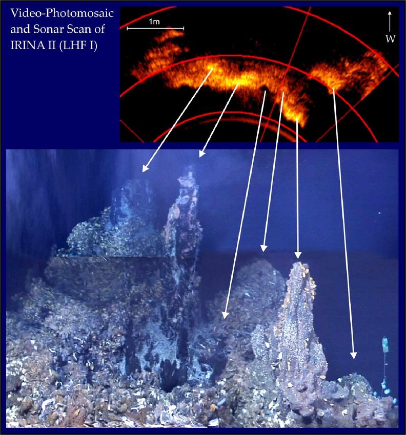
3

               Institut für Biogeochemie und Meereschemie
               Bundesstr. 55
               D-20146 Hamburg / Germany
IfM-GEOMAR     Leibniz-Institut für Meereswissenschaften
               Düsternbrooker Weg 20
               D-24105 Kiel / Germany
               Wischhofstr. 1-3
               D-24148 Kiel / Germany
IfG            Universität Kiel
               Institut für Geowissenschaften
               Olshausenstr. 40
               D-24098 Kiel / Germany
IUB            International University Bremen
               Geosciences and Astrophysics
               P.O. Box 750561
               D-28725 Bremen / Germany
MARUM          Zentrum für Marine Umweltwissenschaften
               Universität Bremen
               Postfach 330440
               D-28334 Bremen / Germany
MPI-Bremen     Max-Planck-Institut für Marine Mikrobiologie
               Celsiusstr. 1
               D-28359 Bremen / Germany
Oktopus GmbH   Kieler Str. 51
               D-24594 Hohenwestedt / Germany
RCOM           Forschungszentrum Ozeanränder an der Universität Bremen
               Postfach 330440
               D-28334 Bremen / Germany
Senckenberg    Forschungsinstitut Senckenberg
               Senckenberganlage 25
               D-60325 Frankfurt a. M. / Germany
SOC            Southampton Oceanography Centre, European Way,
               Southampton SO14 3ZH, U.K.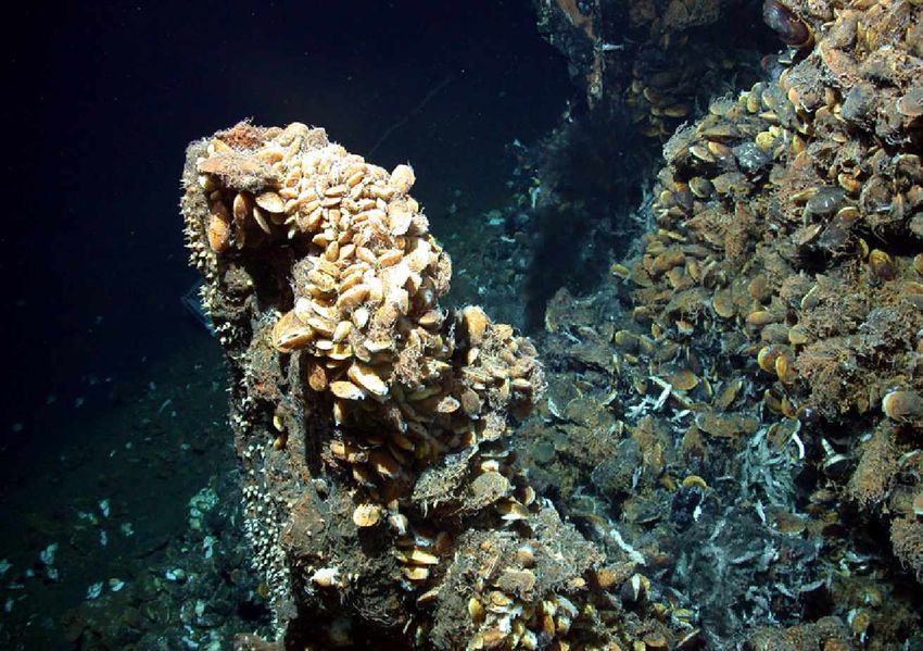
4

2.2   Research Program
(K. S. Lackschewitz, H. Villinger)

The investigations of this cruise are a continuation of the program started between 14°45’N
and 15°05’N on the Mid-Atlantic Ridge in 2004 (cruise M60/3). While in the 2004 cruise basic
geochemical and biological studies were carried out in the Logatchev hydrothermal field, the
emphasis of the 2005 cruise lies on the temporal variability of fluid emanations, fluid
temperature and chemistry, microbial activities and associated fauna at selected
hydrothermal vent sites. The overall goal of the proposed cruise is to advance the integrated
study of the 14°45’N hydrothermal sites further through multi-disciplinary characterization
and sampling at several sites. Biological, mineralogical and hydrological samples are to be
taken in a well-characterized thermal environment so that the results on the samples can be
interpreted in terms of the influence of the important environmental parameter temperature.
The cruise is the second in a number of cruises within the 6-year SPP program, dedicated to
a long-term study in this area to investigate medium-term variability in the hydrothermally
active sites and the related geochemical and biological consequences.
Long-term monitoring of all relevant environmental parameters is essential to assess the
temporal variability observed in the biogeochemistry of the hydrothermal field. The
parameters are (a) temperature, (b) absolute pressure, (c) mean micro seismicity and (d)
local sea floor tilt. We will observe correlation and coupling between hot fluid outflow,
hydrothermal activity, tidal loading, micro seismicity and recent tectonic processes with high
resolution of amplitudes and time. Additionally, a plume temperature profiler for mapping the
extend of the hydrothermal plume, a distributed temperature sensing system for monitoring in
particular biological communities at the sea floor, a ROV temperature lance with online data
transfer over the ROV communication system up to the ship and a temperature calibration
facility for the temperature sensors is provided. Temperature measurements, the use of
sensors and the sampling of fluids to determine the chemical composition of the fluids,
material fluxes and spatial and temporal gradients give the basic information to characterize
the environment in which the ecosystem develops. Three groups are mainly interested in the
characterization of free living microorganisms, which are involved in carbon and sulfur
cycling in hydrothermal vent areas. Methane consuming communities are studied in
hydrothermal fluids, sediments and crusts with a special focus on the process of anaerobic
oxidation of methane and in close cooperation with the gas geochemistry group. Another
group is predominantly interested in sulfur bacteria and in the influence of temperature on
microbial communities, cooperating closely with the groups analyzing sulfur species and
isotopes. Environmental genomics are applied to investigate the metabolic capabilities of
these microbial communities, thereby focusing on the finding of new genes and unexpected
metabolic properties. The development of symbiotic communities (bacteria and host fauna) is
directly related to the chemical content and energy of the fluids. However, the pathway of
interactions does not only involve influence of the fluids on the development of organism
communities, but microorganisms and fauna also change the fluid chemistry due to their
uptake and excretion of chemical compounds.
Samples for the biologists are chosen in cooperation with the geochemists measuring the
different abiotic parameters. The samples are shared between the different groups, analyzed
5

in close collaboration and the results will be finally evaluated in the context of all geochemical
and microbiological findings with respect to the bio-geo coupling. The aim is to develop an
overall model for the temporal and spatial development of the Logatchev hydrothermal
ecosystem, which also includes control by general environmental parameters such as water
depth and geological conditions.

2.3   Narrative of the cruise
(K.S. Lackschewitz)

The final preparations for cruise M64/2 were completed onboard the R/V METEOR in the
harbour of Fortaleza (Brazil) between May 3 and 6. All 22 scientists of Leg M64/2 boarded
the ship on May 5. A test of the ROV vehicle in the harbour was successfully carried out at
midday on May 6.
The R/V METEOR cleared the port of Fortaleza in the afternoon of May 6 and began her
transit to 13°30’N and 45°00’W. The scientists used the five-day transit to set up the
laboratories and to test their sensors and water sampling equipment. Scientific work started
in the afternoon of May 10 with a reference CTD hydrocast station at 13°30'N/45°00’W for
sampling seawater from different waterdepths. Hydrosweep mapping along the ridge axis
was carried out during the night. A 90 minute transit to our main working area, the Logatchev
hydrothermal field (LHF-1; 14°45.20’N/44°58.80’S), was followed by a CTD hydrocast station
to investigate the hydrothermal plume over the LHF-1.
In the morning of May 11 the first ROV station failed shortly after deployment due to
communication problems between the ROV and the control container. Therefore, a hydrocast
station was carried out SW of LHF-1 to investigate the hydrothermal plume dispersal in the
water column. A TV-grab (222GTV) was taken about 300m SW of LHF-1 in order to sample
the periphery. The samples comprised of serpentinized ultramafics, partly covered with Mn-
crusts, and one rock with atacamite. The night of May 12 was filled with a MAPR (miniatur
autonomous plume recorder) string jo-jo (5 MAPP’s and 20 temperature loggers) to trace the
turbidity anomalies of the hydrothermal plume in the area of LHF-1.4.
On May 12 another attempt of a ROV dive failed again due to communication problems. A
TV-grab station taken ca. 50 m southwest of IRINA II sampled ultramafics and Mn crusts. In
the afternoon we started our first successful ROV dive (224) during our cruise M64-2. After
reaching the seafloor we obtained an acoustic signal from the homer beacon 12 which we
set up as a reference station during the cruise M60-3 at the QUEST site. We set up another
beacon (Nr. 14; 14°45,199’N/44°58,783’W) and an ocean bottom tilt meter (OBT) ca. 42 m
southwest of beacon 12. Fluid samples and temperature measurements were taken at a
small active black smoker close to the IRINA-II smoker complex.
We continued our geological program with a TV-sled track from the NE to the SW over the
LHF-1 in order to find hydrothermal precipitates and map the distribution of ultramafics in this
area. Another hydrocast station should further map the distribution of the hydrothermal plume
in the water column, whereas a stationary MAPR string over this area should map the
temporal variations of the proximal hydrothermal plume.
During May 13 a ROV deployment was not possible due to a high sea swell.
6

The night to the May 14 was filled with two TV-grab stations and one hydrocast station. 229
GTV was taken ca. 50 m west of ANNA LOUISE. The samples comprised of weakly
indurated to higher indurated brownish sediment, dark grayish sediment with fine dispersed
pyrite crystals, and several Mn-crusts . At station 230 GTV south of „A“ the samples consist
of altered coarse-grained to pegmatoid orthopyroxenites. The hydrocast station (231CTD)
sampled the hydrothermal plume ca. 200 m northwest of the QUEST site.
During dive 232ROV on May 14 biological and fluid samples were taken from a mussel field
at the southern rim of the IRINA II compex. A special objective was a mussel transplant
experiment. In this experiment we are investigating how the removal of the mussels from the
vent fluids will influence them and their symbiotic bacteria. Before collecting the mussels,
insitu measurements of several physico-chemical parameters were taken (oxygen,
temperature, sulfide, hydrogen, pH) with a profiler module. In addition, fluid samples were
taken.
Plume mapping with the CTD was carried out during the night of May 14 to 15. The
northernmost CTD station detected three turbidity anomalies at 2700 m, 2900 m and 3050 m
ca. 1.5 km NNW of the LHF-1 suggesting at least one other unknown hydrothermal source. A
TV-grab (station 239) was taken ca. 250 m northeast of IRINA-II in order to sample the
periphery of the LHF-1. Beside much sediment, crusts covered with atacamite and several
pieces of talc were detected. On the sediment surface we found several mussel shells of
Bathymodyolus and Phymorhynchus.

Fig. 2.1: Bathymetric map of the working area produced with Hydrosweep during the cruise
M64/2. The location of the Logachev-1 hydrothermal field is indicated by the red dot.

Hydrosweep mapping along 5 profiles was carried out during the night of May 16 to 17. The
objective was to map the upper ridge flank east of the Logatchev field (Fig. 2.1).
During dive 244ROV on May 17 the OBT was set up on a plain place together with beacon
14 to the SW of IRINA II. In the following we have continued the mussel transplant
experiments of 232ROV by taking 5 nets with mussels and puting them in the inactive area of
the OBT. Temperature measurements in the mussel field produced readings ranging
between 5 and 50°C. Four hydrocast stations (stations 245 to 248) were carried out in the N
of LHF-1. The objective of these stations was to investigate the distribution of the turbidity
anomalies in 2700 m, 2900 m and 3050 m.
On May 18 station 249ROV was reserved for fluid sampling of black smokers at ANNA
LOUISE and IRINA I. At both sites temperature measurements with an 8-channel
temperature probe produced values of 205°C and 188°C, respectively. A TV-grab (st 250)
7

between IRINA II and site „B“ sampled a thick sediment unit showing colors from yellowish
brown, reddish brown and green. A temperature measurement in the sediment yielded still
43°C. In addition, samples consist of silicified crusts and highly altered peridotites and
pyroxenites.
The dive 252ROV on May 19 aimed at detailed mapping the southernmost area of LHF-1
including site „A“ which was not discovered during M60/3. After the installation of beacon 11
at IRINA I site we started our mapping profiles south of ANNA LOUISE. On the second
profile we found a 5m high active black smoker which is related to site „A“, first described by
Gebruk et al. (1997). We named this smoker „Barad-Dûr“ after the black tower of Mordor in
the book „Lord of the Rings“. We sampled several sulfide fragments from the underlying
mound of Barar-Dûr and another rock sample from the IRINA I site.
Four hydrocast station stations (253-256) during the night from May 19 to 20 mapped and
sampled the plume in 2700 to 2800 m ca. 600 m to the northwest of LHF-1.
During the day of May 20 the dive ROV 257 placed 10 temperature loggers in the mussel
field at IRINA II for longterm monitoring. Another main target of this dive was to sample
fluids, sulfides and bacteria mats at site „B“. The onboard analyses of the fluids have shown
a pH of 3.9. The following night two TV grab stations east and northeast of QUEST and a
hydrocast station to the NNW of LHF-1 were carried out. The first TV grab (st. 258) sampled
a few shells of the hydrothermal mussel species Calyptogena and several small peridotite
pieces. The second TV-grab (st. 259) was empty. The hydrocast (st. 260) sampled 11 water
samples from different water depth ca. 1.5 km NNW from LHF-1.
Station 261ROV on May 21 concentrated on fluid sampling at Site „A“ and IRINA. In addition,
sulfides were sampled at both sites. During the night Hydrosweep mapping was continued on
the upper ridge flank to the east.
During dive 263ROV on May 22 a special objective was a sampling program in the area of
the Russian marker ANYA. We sampled two push cores for bacterial studies and mussels
with a net. In addition, we set up a beacon (11) to provide a precise site location because the
original position according to Gebruk et al. (2000) appeared to be northwest of IRINA II.
We continued our program with two hydrocast stations west of LHF-1. Both stations showed
no turbidity anomalies, but water samples between 2700-2800 m have still minor methan
anomalies.
During ROV station 266 on May 23 fluid parameters were measured directly above five
places in a diffuse venting mussel field of IRINA II by the profiler module. After the
investigation of this site we picked up beacon 11 near the marker „ANJA“ and placed it 10 m
east of site „B“. In the following, we took fluid samples at a black smoker which is close to the
sampled smoker of 257ROV. Temperature measurements at both sites show values of
350°C and 300°C..
Four hydrocast stations (st. 267-270) ca. 0.5-1 sm south and southeast of LHF-1 did not
show a turbidity signal of the plume. However, we have still identified the plume by a slight
increase of CH4 in water samples between 2700-2800 m
On May 24 we started with a deployment of a 25 m longterm temperature mooring from the
ship (st. 271). During the following ROV station 272 we repositioned this mooring in the
region between IRINA I and ANNA LOUISE. Another target was the precise horizontal
placement (angle of < 2°) of the OBT at beacon 14. In addition, we placed two push cores in
8

the mussel field of IRINA II for microbial experiments and we took some samples from an
inactive smoker ENE of IRINA II.
Another four hydrocast stations (st. 273-276) have indicated that the eastern ridge flank acts
as a boundary for the distribution of hydrothermal plume to the east and northeast.
During dive 277ROV on May 25 we placed again the profiler module in the diffuse venting
mussel field at IRINA II. Temperature measurements showed values up to 140°C. In
addition, a baited trap was deployed on the mussel bed close to the chimney complex.
Detailed video images were recorded along two horizontal profiles of the eastern part of the
chimney complex for constructing a photomosaic of this whole structure. Diffusely venting
fluids were sampled at the chimney complex close to the area which was already sampled
during M60-3 (st. 38ROV). Hydrothermal fauna were collected here also. At the end of the
dive we mapped the area east of IRINA II along two profiles.
A TV-sled track (st. 278) was carried out 2 sm north of LHF-1 in order to find indications of an
active vent field creating the hydrothermal plume in 3050 m water depth. Due to an electric
failure this station was aborted shortly after the first profile. In following two hydrocast station
were carried out above the QUEST vent site and ca. 3 sm NW of LHF-1.
The main target of dive 281ROV was a sampling program at the QUEST site. First we placed
a benthic chamber on a mussel bed at IRINA II to measure H2 and S2- for several hours. At
QUEST site we sampled fluids and a net of hydrothermal fauna at a diffuse venting mussel
bed. At this site we placed also 9 longterm temperature monitoring loggers. In addition, we
took fluid samples, temperatures and sulfide samples from a hot venting black smoker.
During the following night Hydrosweep mapping was continued on the upper eastern ridge
flank.
At dive 283ROV on May 27 we continued our work at QUEST site. We deployed two 8-
channel temperature loggers in the main mussel bed and sampled diffuse fluids with 3 Niskin
bottles. A camera survey over the mussel bed was made to produce a photomosaic. Next we
placed the OPT on more stable ground and took the last net for the mussel bed experiment.
In the following we finished our sampling program in IRINA II taking another fluid samples,
temperatures at two vents and a net with shrimps. At the end of the dive we picked up the
beacon 13 and the baited trap. The night to May 28 was filled with another TV-sled station
(st. 284) which investigated the area northwest of LHF-1 along several profiles searching
unknown hydrothermal sites.
After this TV-sled track our last ROV station (285ROV) explored and mapped the area
northwest of QUEST site in order to find an unknown vent site. After several profiles we
found a new diffuse venting site with several highly altered crusts ca. 150 m northwest of
QUEST site.
Station work of cruise M64/2 was finished after this station and R/V Meteor started her transit
to Dakar. R/V Meteor arrived the port of Dakar on June 4, at 06:00 am. All containers were
brought to the pier and loaded there by the scientific and technical crew. The scientists of
cruise M64/2 disembarked until the early evening of June 6, 2005.
9
2.4 Preliminary Results
2.4.1 Detailed geological studies of the Logatchev-1 hydrothermal field
(K.S. Lackschewitz, N. Augustin)
The geological setting and structure of the Logatchev-1 hydrothermal field (LHF-1), situated
on a small plateau on the eastern flank of the inner rift valley at 14°45’ N, has been described
by several workers (e.g., Krasnov et al. 1995; Gebruk et al., 1997). Extensive bathymetric
and video mapping of the LHF during the first RV Meteor cruise M60/3 have revealed the
main factors of its tectonic control (Kuhn et al., 2004). Detailed sampling has allowed study of
the interrelationship of geological, geochemical and biological processes of an ultramafic-
hosted hydrothermal system.
The present detailed work carried out during the second RV Meteor cruise M64/2 resulted in
a further mapping and sampling as well as the first deployments of long term monitoring
stations (Fig. 2.2).
Fig. 2.2: Logatchev-1 hydrothermal field with long-term monitoring and TV-Grab stations
(GTV) carried out during M64/2. A new diffuse venting-site is located NW of QUEST.
The LHF-1 extends at least 800 m in a NW-SE and probably more than 400 m in a SW-NE
direction as previously described by Kuhn et al. (2004). At the southeastern end of LHF-1 we
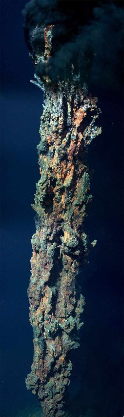
discovered the 5m high black smoker of Site“ A“ which was previously identified by Gebruk et10
al. (1997). We gave this smoker the name „Barad-Dûr“ after the black tower of Mordor in the
book „Lord of the Rings“. Barad-Dûr is sitting on a 3 m-high mound of chimney talus. There
were no mussel beds at this site, and hydrothermal fauna was restricted to shrimps and
crabs on the upper part of the smoker. A photographic and video survey obtained by the
ROV proved to be adequate for preparing a photomosaic of the structure (Fig. 2.3).
Hydrothermal fluids were sampled here for the first time.
The marker „MB“ indicates this site as a reference fluid
sampling station (see Appendix 2). In addition, several
chimney fragments were sampled at the base of Barad-Dûr.
The area northwest of site „A“ is characterised by the three
hydrothermal sites ANNA LOUISE, IRINA und „B“
consisting of smoking craters. At ANNA LOUISE black
smoke was intensely venting from the chimneys on the
crater rim and from holes in the ground within the crater.
Strong bottom currents resulted in almost horizontal plume
dispersal to the south. Therefore, the so-called
„Candelabrum“ chimney on the southern rim of the crater
(Kuhn et al., 2004) was hidden from view during most of our
observations. A 25 m-long temperature sensor mooring,
which we have set up between ANNA LOUISE and IRINA,
should measure the temperature variations of the plume
dispersal over several months. Hot fluids and chimney
fragments were sampled from a black smoker on the
northern crater rim of ANNA LOUISE. Other fluid and rock
samples were taken also at IRINA and „B“. We deposited a
marker „MA“ at the sampled smoker of site „B“ and a
marker „MD“ at the sampled smoker of site IRINA.
Temperature measurements of the fluids have shown
values of 205°C for ANNA LOUISE, 177°C for IRINA (at
marker „MD“) and 350°C for site „B“ (at marker „MA“).
Another small smoker at site „B“ has revealed a
temperature of 300°C.
Fig. 2.3: Photomosaic of Barad-Dûr (Site A).
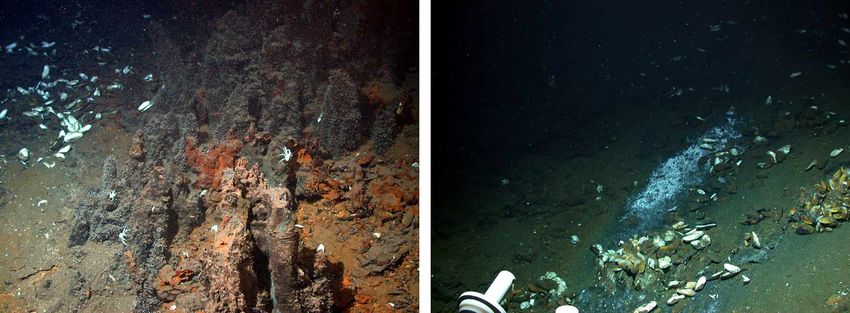
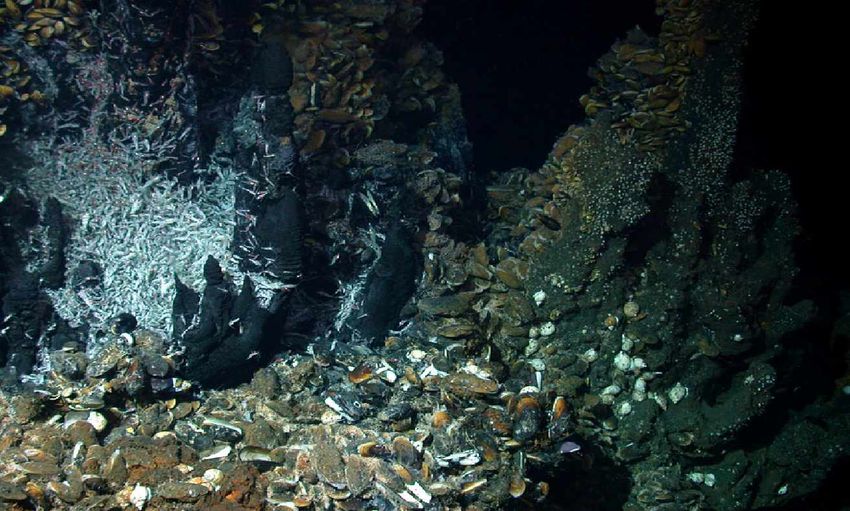
The largest site in the LHF-1 is IRINA II which was one of main targets of our biological
studies. IRINA II consists of a mound with steep slopes rising about 15 m above the
surrounding seafloor. A chimney complex, ca. 2 m high, marks the top of the mound. Based11 on a video and photographic survey we were able to create a photomosaic of this smoker complex (Fig. 2.4). A sonar scan shows clearly the different chimney structures. Fig. 2.4: Photomosaic and Sonar Scan of the eastern IRINA II chimney complex. Most of the chimneys are densely overgrown with mussels (Bathymodiolus). Shrimps (Rimicaris exoculata) are highly concentrated over low-temperature fluids along the sides of the chimneys. The chimney complex is surrounded by densely populated mussel beds and by small active and inactive chimneys. Temperature measurements at a small active chimney on the northwestern side yielded values of up to 170°C, whereas a small chimney in between the complex revealed values of up to 225°C. These chimneys were also sampled for hot fluids. The mussel beds around the chimney complex are characterized by diffuse venting fluids. The temperatures of these emanating fluids, which were measured by a profiler module have shown a temperature range of 2.6° to 8°C (see chapter 2.4.10). We placed ten temperature loggers on a mussel bed at the southeastern side of the smoker complex to monitore the diffuse venting fluids for several months. A special objective was a mussel transplant experiment. In this experiment we are investigating how the removal of the mussels from the vent fluids will influence them and their symbiotic bacteria (see chapter 2.4.9).
12
As already described by Kuhn et al. (2004) the area around the Russian marker ANJA is
located at a slope approximately 30 m northwest of the IRINA II-complex. This marker
identifies a site called ANJA’S GARDEN in Gebruk et al. (2000) and these authors described
that it occurs a 100 m northwest of IRINA-II. Based on our precise DVL navigation, we
assume that the Gebruk et al. (2000) description of the ANJA marker location is incorrect. At
the ANJA marker we found clusters of living and dead Bathymodiolus shells together with
shimmering water. Visual observations during our dives in this area indicated that vesicomyid
clams might be present. However, a ROV sample taken from the area of an old marker „C“,
which is located close to the ANJA marker, revealed only Bathymodiolus shells.
Just north of the IRINA II mound we placed an Ocean Bottom Tiltmeter (OBT) and an Ocean
Bottom Pressuremeter (OBP) as longterm monitoring stations (see chapter 2.4.5) close to
the new LHF-1 reference beacon 14 (14°45.199’N / 44°58.783’W).
The QUEST site, which was newly discovered during our first Meteor cruise M60/3 (Kuhn et
al., 2004), is situated ca. 130 m WNW of the chimney complex of IRINA II. It is characterized
by a smoking crater surrounded by several small active chimneys. Fluids and chimney
fragments were sampled from a small black smoker on the northeastern side of the crater
indicated by the marker „MC“. We have measured here fluid temperatures up to 285°C.
Elongated clusters of mussels occur southeast of the smoking crater. ROV samples revealed
that the mussels consists of abundant juvenile forms which is in contrast to the high
abundance of adult forms at IRINA II. A temperature logger (#3), which we deployed here on
the M60/3 cruise, showed values of up to 12°C. Therefore, we placed here nine 1-channel
temperature loggers and two 8-channel temperature loggers for longterm measurements.
Mapping the area north of QUEST site with the ROV revealed sediments with ripple marks
intercalated by several ultramafic outcrops. At ca. 150 m northwest of the QUEST site we
found a diffuse venting site with highly altered ultramafics confirming a larger extent of LHF-1
similar to the observation made by Kuhn et al. (2004).
2.4.2 ROV deployments
(G. Ruhland and ROV-Team)
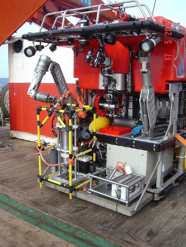
The remotely operated deep diving robot QUEST is an electrical 4000 m rated, work class
ROV, which is operated by MARUM, University of Bremen, since May 2003. The vehicle has
been manufactured by Schilling Robotics, Davis, USA. The total QUEST system weights 45
tons (including the vehicle, control van, workshop van, winch, 5000 m umbilical, launch-and-
recovery-frame, and two transportation vans, all 20-feet-size). The 5000 m of 17.6mm NSW
umbilical is stored and managed by an electrical MacArtney Cormac winch. No hydraulic
connections have to be installed during mobilisation.
QUEST’s first use within SPP1144 took place during Rv METEOR leg M60/3 in January 2004.
The leg M64/2 is the second task of QUEST in the Logachev Hydrothermal Vent Field. The
technical innovations of the ROV provided a flexible and highly adaptable platform for
scientific sampling and observation tasks and therefore played a major role to the scientific
success aboard RV METEOR. Since the previous leg new features have been additionally
installed including the highly integrated USBL positioning system, based on the French13 IXSEA-GAPS inertial Navigation and Positioning system. However, due to a malfunction of the GAPS system Inertial Navigation and Positioning could be used only very limited. In addition, QUEST uses a Doppler velocity log (DVL) to perform StationKeep or Displacement mode, automatically controlled 3D positioning, and other auto control functions. Navigational purposes were supported by an array of Sonardyne HF beacons set in the vent field. An additional frame installed in the ship’s A-frame enables much smoother and safe handling of the ROV during launch and recovery. Fig. 2.5: Launching of the ROV with an additional frame at the aft (Photo: D. Garbe- Schönberg). The QUEST system can be precisely controlled with its 60 kW electric propulsion system and is operated as free-flying vehicle. No tether management system (TMS) has to be operated at the same time the ROV is working. The collection of biological and geological samples and the pumping of fluids could be done with two installed robotic arms. While the RIGMASTER manipulator can lift and handle devices or samples up to 250 kg, the ORION manipulator is used to handle probes or work on delicate tasks. A set of video and still picture cameras together with a 2.4 kW light suite provides possibilities for video mapping and photo mosaicing. Therefore two green lasers which are installed parallel to each other can be used as size relation. Due to a water leak the Insite Pacific ATLAS camera could be used on the first four dives only. Besides cameras and manipulators, the scientific equipment installed during leg M64/2 constisted of a CTD with turbidity and high-temperature sensors, which could be used only on three dives due to a water intrusion in the housing. A set of niskin bottles, a 675 kHz scanning sonar, a sample drawbox and several different sampling tools such as “hand” nets and grabbing devices complete the installed equipment.
14
The scientific data base system used at MARUM feeds all ROV- and ship-based science and
logging channels into an adapted real-time database system (DAVIS-ROV). The QUEST
control system provides transparent access to all RS-232 data and video channels. During
operation data and video has be distributed by the real-time database via the ship’s network
system in different laboratories and supply the scientists with data from their own devices.
Dive summaries containing all data of interest including video and digital still photographs
were compiled after each dive. Using the database's export capabilities in combination with
the software product "ADELIE" developed at IFREMER, GIS based plots, data graphs and
divetrack maps containing time and position-referenced scientific data, video and images
were available shortly after or even during the dives.
Post-cruise data archival will be hosted by the information system PANGAEA
(www.pangaea.de) at the World Data Center for Marine Environmental Sciences (WDC-
MARE), which is operated on a long-term base by MARUM, University of Bremen, and the
Foundation Alfred Wegener Institute for Polar and Marine Research, Bremerhaven (AWI).
During leg M64/2 QUEST could be successfully deployed 15 times while 14 of these dives
reached the bottom. Launch and recovery has been done at sea states up to 2.5 m and
winds of up to 6 bft.. Total bottom time of 110 hours could be achieved at depths of 2950 to
3050m. The planned scientific program could be finished completely during the leg. Beneath
scientific sampling and photo mosaicing the current working map could be improved and
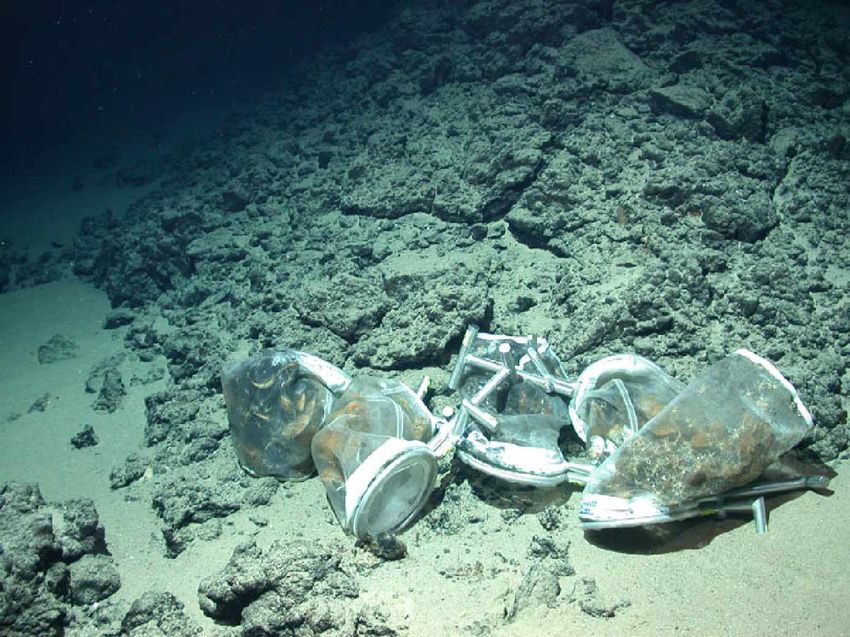
completed in some parts. Two scientific devices, an ocean bottom tiltmeter (OBT) and an
ocean bottom pressure sensor (OBP) had been transported with the ROV to the bottom and
installed during the dives. 24 temperature loggers for a yearly monitoring program were also
distributed in mussel fields. A profiler frame and a benthic chamber had been successfully
transported and set with the ROV several times for a daily monitoring.
During all operations, the crew of RV METEOR provided a very successful and smooth
handling on deck, excellent navigation and professional technical support to fulfill the
scientific tasks required.
2.4.3 OFOS deployments
(N. Augustin, H.-H. Gennerich, K.S. Lackschewitz, H. Marbler, T. Pape, S. Weber, G.
Schroll)
A total of 3 TV-sled stations were carried out in the vicinity of LHF-1. The objectives of the
OFOS (Ocean Floor Observation System) stations were to find signs of unknown
hydrothermal activity.
The IFM-GEOMAR TV-sled was equipped with a BENTHOS photo camera and flash, a
SONY digital camcorder and a FSI 3’’ memory CTD probe. During our first OFOS-station 226
we have mapped a NW-SE profile between 14°45.4’N / 44°58.35’W and 14°44.85’N /
44°59.1’ W crossing site „B“ of LHF-1 (Fig. 2.6). The beginning of the profile is characterized
by a talus field followed by sediments, where we found four temperature anomalies with an
increase of 0.03°C. One of this anomalies is close to 239GTV-station showing a temperature
of the sampled sediments of 43°C onboard. When we crossed site „B“ no sign of
hydothermal activity was visible. However, we have measured a temperature anomaly of15 0.06°C. The area southeast of LHF-1 is characterized by sediments, some talus and an ultramafic outcrop showing a temperature anomaly of 0.025°C. Station 278OFOS was carried out to investigate observations during M64-2 stations 238CTD; 253CTD and 273CTD, where physico-chemical parameters in the water column suggested a yet undiscovered fluid source different from the known black smokers of the LHF. The OFOS was equipped with one MTL (Miniature Temperature Logger; see chapter 2.4.5) and one MAPR (Miniature Autonomous Plume Recorder; see chapter 2.4.6.2). Due to cable problems station 278OFOS was interrupted early after 1.5 hrs. Consequently the area between LHF and the water chemical anomaly in it’s northwest was the target of the next OFOS survey, station 284OFOS. This time OFOS, bottom control weight and deep-sea cable were equipped with a dense array of 5 MAPRs, 20 MTLs and 1 CTD between the seafloor and up to 100 m above it, with singular extra sensors in 125 m and 170 m height. Same as station 226OFOS, also stations 278OFOS and 284OFOS did not show any hints to hydrothermal activities by visual observations. The CTD results of these stations are presented and discussed in chapter 2.4.6.2.
16

Fig. 2.6: Track of 226OFOS in the vicinity of the active Logatchev-1 hydrothermal field.
         Insert: Water temperature versus time-diagram of OFOS station 226 showing
         several distinct temperature anomalies between 0.025 and 0.06°C.
17
2.4.4 Description of rocks and hydrothermal precipitates
(N. Augustin, H. Strauss)
During cruise M64/2 a total of 14 ROV dives and 8 TV-grab stations recovered geological
samples from the seafloor. Information on all sampling stations is given in Table 2.1. A more
detailed description of the individual samples is provided in Appendices 4 and 5.
Tab. 2.1: List of geological samples with geographical positions of individual stations.
Lat Long Station Sample types
14°44.99´N 44°58.97´W 222 GTV serpentinized pyroxenites
14°45.19´N 44°58.82´W 225 GTV serpentinized pyroxenites, Mn-crusts
14°45.08´N 44°58.72`W 229 GTV silicified crusts, consolidated sediments, sulfidic muds
14°45.01´N 44°58.68´W 230 GTV Mn-coated pyroxenites, weakly weathered
14°45.23´N 44°58.58´W 239 GTV atacamite and silicified crusts
14°45.18’N 44°58.73’W 244 ROV altered sulfide breccia
strongly altered peridotites and pyroxenites, quartz-
14°45.16´N 44°58.77´W 250 GTV veins
14°45.04’N 44°58.63’W 252 ROV sulfides chimney-pieces
14°45.12’N 44°58.70’W 257 ROV Fe-oxide-hydroxide crusts, sulfides
14°45.21´N 44°58.76´W 258 GTV some Mn-Coated serpentinite pebbles
14°45.24´N 44°58.84´W 259 GTV GTV empty
14°45.06’N 44°58.64’W 261 ROV sulfide chimney
14°45,10’N 44°58,67’W 266 ROV sulfides
14°45.20’N 44°58.74’W 272 ROV iron-oxide and -hydroxide crusts
14°45.20’N 44°58.74’W 277 ROV sulfides
14°45.21’N 44°58.81’W 281 ROV sulfides
14°45,32'N, 44°58,84'W 285 ROV Fe-oxide, -hydroxide crusts and mud
In general, serpentinized peridotites represent the host rocks of the Logatchev field.
Remarkable are samples of coarse grained orthopyroxenites, which are interpreted as
magmatic cumulates from the crust/mantle transition zone. Apart from these host rocks, a
large variety of hydrothermal samples were collected, confirming the observations made in
2004 during Meteor cruise M60/3. Samples include pieces of active and inactive chimneys,
massive sulfides, silicified breccias and crusts, hydrothermal sediments, abundant secondary
Cu-sulfides, hematite impregnated serpentinites, abundant Fe-Mn-oxyhydroxides as well as
atacamite and Mn-oxides.
Several TV grabs (222GTV, 225GTV, 239GTV, 250GTV and 258GTV) recovered variably
altered serpentinized pyroxenites (Fig. 2.7), some of which were coated with a thin Mn-oxide
layer. Of these, 250GTV recovered strongly altered peridotites and pyroxenites (a 25cm thick
layer). In situ temperatures measured in the unconsolidated material onboard yielded18 Fig. 2.7: Geological samples recovered during GTV and ROV stations: 222GTV-1A: altered serpentinized pyroxenite; 225GTV-1A: serpentinzed pyroxenite; 239GTV-1A: atacamite crust; 252ROV-2: chimney piece, collected at IRINA I, composed of layers of chalcopyrite; 229GTV-1A: reddish silicified crust with dark brown Mn-oxide coating; 281ROV-7: chimney piece, collected at QUEST site, composed of chalcopyrite with Cu-sulphide rich outer layers temperatures up to 43°C. This shows that hot fluids circulate beneath the sediment without necessarily venting at the seafloor. 239GTV recovered similar material (this time a 10cm thin and cold layer), with thick atacamite-crusts, hematite impregnated serpentinites, talc and serpentine-breeze. This suggests the presence of an old inactive fluid-pathway. 258GTV contained reddish pelagic sediment, some Mn-coated serpentinite pebbles and empty Calyptogena shells. 259GTV grabbed a large boulder, was opened again, and returned empty. Geological sampling during the various ROV dives recovered mainly sulphide samples, either from active or inactive chimneys and/or sulphide talus samples. Most massive sulphide
19

pieces were composed of chalcopyrite, sometimes displaying a distinctive layering. Other
samples comprise more porous chalcopyrite rich interior portions and clearly layered parts
towards the outer rim. Occasionally, different fluid conduits could be recognized. The outer
rim of all sulphide pieces was generally covered with a thin Fe-oxide coating. 252ROV
recovered a large number of pieces which, apart from chalcopyrite as major sulphide, contain
abundant colourful copper-rich sulphide minerals (Fig. 2.7). During 261ROV, a fresh sulphide
piece comprising largely chalcopyrite was collected from the Barad-Dur chimney at Site A.
Further chimney pieces, composed mainly of chalcopyrite and showing individual orifices
(Fig. 2.7), were recovered from IRINA II (277ROV) and the QUEST Site (281ROV).

2.4.5 Environmental parameters and longterm monitoring
       (M. Fabian, H.-H. Gennerich)

Deployment of long term monitoring instruments

The ocean bottom tiltmeter (OBT) is a platform tiltmeter with two perpendicular axis, X, Y
(Fig. 2.8). It has also a high performance MEMS (Micro-Electro-Mechanical-System)
accelerometer whose axis is aligned parallel to the OBTs vertical axis and measures total
gravity g. The photo shows the OBT in the laboratory of RV Meteor. The OBT uses a biaxial
bubble tilt sensor of type Applied Geomechanics Inc. 756. The single-axis accelerometer is
of type Kistler Servo K-Beam 8330A2.5 .
The OBT will record local sea floor tilt caused by e.g. tectonics, tidal loading, changes in
hydrothermal and deeper magma-plume activity and soil movements like landslides with 1
micro radiant resolution and 6 second sampling interval. Acceleration caused by e.g. micro
seismicity, earthquakes or tremors will be measured with 10-5m/s2 resolution at 0.75 seconds
sampling rate. The aluminium frame consists of a rectangular triangle base plate with a tripod
                         and a frame for handling. The larger titanium pressure tube houses
                         batteries, data logger and electronics. The smaller aluminium tube is
                         fixed to the base plate and contains the sensors. The OBT has a
                         deep sea spirit level for levelling the instrument. A good coupling of
                         the instrument to the ground is necessary.

                         The OBT was deployed (14°,45.201’N, 44°,58.784’W, 3053m depth;
                         see Fig. 2.9) in the LHF south east of “QUEST” site and west of site
                         “IRINA II” (see Appendix 1). For navigation purposes and to facilitate
                         revisiting an acoustic beacon (No. 14) was placed at this station (see
  Fig. 2.8: OBT          chapter 2.4.1). The OBT was installed on the hilltop of a rock pile by
firmly and carefully pressing and moving the legs of the instrument. Orientation of the +Y-axis
with respect to the directions of the compass is 295°±3°. The place of the OBT is apart vent
sites that measurements are not influenced by hot fluids.
20
Fig. 2.9: The map shows the location where monitoring systems were installed. QUEST and
IRINA II were equipped with temperature loggers, OBT and OBP and MOORING
with the bottom water monitoring profiler.
The Ocean Bottom Pressuremeter (OBP), which was deployed close to the OPT (Fig. 2.10),
measures changes in the water pressure at the sea floor very precisely to get exact local
information about tides and level changes due to subsidence or uplift of the seafloor,
indicating tectonic magmatic or hydrothermal activities. The OBP was designed very robust
with a strong frame on three short legs and the pressure cases installed with clambs inside.
The instrumentation consists of 3 pressure cases with a Brancker XR-420 data logger with
built-in temperature sensor, a lithium battery pack (10,5 V, 56 Ah) and a Paroscientific
Digiquarz pressure gauge.
This base station was configured to sample pressure and temperature at 2 min intervalls. A
30 s pressure integration time was chosen providing a pressure resolution > 1 mm water
column. This base station was brought to the sea floor (19.05.05, station 244ROV dive 52)
and repositioned to it’s final position (22.05.05, station 263ROV; dive 57). Crucial for the
choice of the position was a location where no level changes due to sinking of the instrument
into the sediment or due to redeposition of sediments was expected. The final deployment
position shows only minor ripples indicating little sediment transport and closeby outcropping
solidified material suggests only thin sediment cover.21
Fig. 2.10: OBP (left) and OBT (right) deployed at their final positions west of IRINA II.
The distributed temperature sensing instrumentation monitors temperature variations in the
biological communities as an indicator for changes in their living environment due to
variations in hydrothermal activity. So the deployment locations were chosen at spots of
focussed biological and fluid sampling investigations.
The set of instruments consists of 20 1-channel temperature loggers (MTL) inserted into 40
cm long T-shaped steel tubes for easy ROV-deployments and four units each of a 8-channel
temperature lance connected to a data logger with a 1 m cable. The temperature resolution
is < 1 mK at an absolute accuracy < 5 mK. The 1-channel loggers were set up to sample at
6 min intervals, the 8-channel loggers at 2 min intervals.
The first set of instruments consisting of 10 1-channel loggers sequentially numbered from
#1854200 to #1854209 was labeled with 10 cm buoyant cylinders #0 to #9. They were
deployed (20.05.05, station 257ROV, dive 55) in the IRINA II mussel field (Fig. 2.11) The
arrangement was installed in two parallel lines of 5 loggers each perpendicular to the mussel
field’s length axis until the rim of the mussel covered area. Shimmering water indicates
elevated water temperature above the mussel field.
Fig. 2.11: Part of the 1-channel temperature logger array in IRINA II mussel field (left) and
QUEST mussel field (right).22
The second set of 10 MTLs (#1854210 to #1854219) labelled as #10 to #19 was deployed
(30.05.05 station 281ROV, dive 61)) in the QUEST mussel field (Fig. 2.11) which has an
extension of about 0.6 x 3 m . The loggers were arranged along the field’s length axis spaced
< 0.5 m with an additional cross profile and one extra logger 1 m beside in a bacteria mat.
Two 8-channel loggers (#10295, #10298) were placed (31.05.05, station 283, dive 62)
horizontally and vertically at the same location where the mussel field shows maximum
thickness. An other set of two 8-channel loggers (#10296, #10297) was placed in the same
configuration in the IRINA II mussel field, ca. 4 m beside the 1-channel logger array.
Two MTLs deployed during cruise M60/3 were recovered from the IRINA II and QUEST site
mussel fields. Data show in a 1 week time series periodic changes in temperature up to 6°C
resp. 12°C with a periodicity which seems to be related to the ocean tides or multipliers of it.
Fig. 2.12: Temperature time series in IRINA II (left) and QUEST (right) mussel field.
The bottom water profile monitor (BWPM) will register the variation of the
bottom water temperature caused by changes in hydrothermal activity and
water currents.
The BWPM is constructed as a mooring where two 17’ glass balloons with
a total buoyancy of 56 kg are connected by a 25 m long rope to a bottom
weight of 100 kg (Fig. 2.13). A 25 m long sensor cable with 24
temperature sensors 1 m spaced and a Brancker XR-420-T24 24 channel
data logger are attached to it. Acoustic beacon #15 was also attached to
the mooring 20 m above the sea floor for easy finding and general
navigation purposes in the Logatchev hydrothermal field. The logger is
configured to register the temperature in 1 min time intervals at 24
equidistant positions equally spaced by 1 m at a temperature resolution of
better than 1 mK and an absolute accuracy of 5 mK.
The BWPM was lowered to the sea floor with the oceanographic wire, an
additional weight of 300 kg and an acoustic releaser. The ROV collected
Fig. 2.13: The the mooring from the sea floor by grabbing into a prepared loop of buoyant
BWPM rope attached to the bottom weight and transported it to the final position
between the black smokers and smoking craters of ANNA LOUISE and
IRINA I. While the location is in the vicinity of these highly active areas to get significant
signals, the BWPM keeps outside the high temperature vents.23 Environmental mapping and online tools The ROV temperature lance is intended to measure real time temperature at spots of interest as well as the gradient and width of the temperature anomalies. It is designed as a 0.5 m long lance with 8 evenly (4 cm) spaced temperature sensors inside and connected to a 8- channel logger. The logger provides a RS-232 data stream, which is transmitted in real time through the ROV-cable to the ship. The lance measured temperatures of up to 210 °C in a black smoker at ANNA LOUISE. Additonally mussel fields and bacteria mats were probed. Finally the connector at the lance broke as it was not sufficiently robust for the ROV handling; it will be replaced by a stronger one for the next cruise. Fig. 2.14: 8-channel ROV-temperature lance placed in the black smoker of ANNA LOUISE (left) and the results (right). With the plume temperature profiler the water column is scanned for signs of a hydrothermal plume. For this purpose a set of MAPRs and 20 miniature temperature loggers (MTL) were attached to the oceanographic wire and towed through the water column while the ship was steaming slowly at 0.5 knts. During station 223 a grid of 4 equally spaced parallel profiles covering an area of about 4 km2 above the Logatchev hydrothermal vent field was surveyed. MAPRs and MTLs were attached over a length of 600 m. The TowYo approached the sea floor to 50-100 m with an amplitude of 200 m. During station 228 the variation of temperature and turbidity were recorded in the center location of station 223. All surveys revealed that the upper plume between 2700 m and 3000 m is very clearly visible by increased turbidity in MAPR and CTD data. At the same time a sudden decrease in temperature gradient compared to the normal gradient is observed. The signal in the temperature is less obvious than the one in the turbidity.
24

Fig. 2.15: Comparison of temperature and turbidity signal at the same time and position in
           the upper plume above the Logatchev hydrothermal field in a depth of 2700 to
           3000m, indicating it’s easier recognition by turbidity measurements.
25
At station 284 the OFOS was used to follow the sea floor with a constant distance of 2 m,
while observing the sea floor for indicators of hydrothermal activity. A set of 20 MTLs and
5 MAPRs were attached to the wire and to the bottom distance control weight below the
OFOS. This way the bottom water column of 100 m was surveyed in detail on three parallel
tracks evenly spaced by 100 m.
Different from the upper plume, a bottom water plume could be identified in the interval
between 2-10 m above the seafloor. This bottom plume is seldom visible by increased
turbidity, but can be easily identified by temperature signals of 30 mK to 50 mK. The bottom
plume seems to indicate hydrothermal activity from diffuse venting sites, which don’t produce
big amounts of particles like the black smokers do. Thus future cruise could be guided by
observing the temperature anomalies in that depth interval to find diffuse venting sites.
Fig. 2.16: Several “blank” areas in the temperature graph between the bottom sensor and
sensors of more than 10 m above the sea floor indicate diffuse venting, as was
proved by finding in the vicinity of the marked spots. No turbidity anomaly was
found in these cases. Future investigations of the Logatchev hydrothermal field
could be guided by this finding.
Results from station 226 suggest to have a closer look to an area 500 - 1000 m to the NW of
the Logatchev vent area for diffuse venting sites.You can also read