Aquatic Pest Report 2019 - Bay of Plenty ...
←
→
Page content transcription
If your browser does not render page correctly, please read the page content below
Aquatic Pest Report 2019
Heading/title
Bay of Plenty Regional Council
Environmental Publication 2019/03
February 2019
Subheading
Prepared by Freya Ewing and Thomas Bailey (Summer Students)
Month
5 Quay Year
       Street
P O Box 364
Prepared
Whakatāneby
NEW ZEALAND

ISSN: 1175-9372 (Print)
ISSN: 1179-9471 (Online)

Cover photo: Rowan Wells (NIWA)
Acknowledgements
We would like to thank Hamish Lass, Biosecurity Officer for his support and guidance, and
Lucas MacDonald, Biosecurity Officer for his assistance and advice across all advocacy
work.

Our acknowledgements also go to Greg Corbett and the remainder of the Biosecurity Team
at the Bay of Plenty Regional Council, we are grateful for the encouragement and support
we received from all of you.

We would also like to show our gratitude to Geoff Ewert for his continued commitment to
the Rotorua Lakes, in particular with fixing weed cordons and the running of the boat wash
station. We are also immensely grateful to Sarah Van Der Boom from Freshwater
Biosecurity Partnership Program for her help with data collection.

Lastly, we would like to thank Sam Beaumont and the remainder of the team at Ministry for
Primary Industries, for the supplying of merchandise and collateral, signage and guidance.

BAY OF PLENTY REGIONAL COUNCIL TOI MOANA                                                     1
Executive summary
Many of New Zealand’s most well-known lakes and rivers can be found in the Bay of Plenty
region and are therefore known to attract significant visitor numbers annually. The
preservation and protection of these waterways are what attracts so many international
and domestic tourists to them. Due to the close proximity of the Bay of Plenty lakes and
rivers, and their popularity, they are extremely susceptible to invasive pest species.

Four main pest weeds have been identified in the Bay of Plenty waterways, these species
are; Elodea canadensis (Canadian Pondweed), Egeria densa (Egeria), Lagarosiphon major
(Lagarosiphon) and Ceratophyllum demersum (Hornwort). These species contribute greatly
to water degradation and have adverse effects upon recreational activities. It is these
recreational activities however which typically is the principle means by which weed
fragments are spread between waterways in New Zealand’s water bodies. Pest fish eggs
could also possibly be hidden among weed fragments. There are specifically two pest fish
of most concern in the Bay of Plenty region, these are Cyprinus carpo (Koi Carp) and
Ameiurus nebulosus (Brown Bullhead Catfish). Similar to pest weed species pest fish have
the ability to degrade water quality, affect recreational activities and threaten native
species.

The Aquatic Pest Awareness Programme (APAP) aims to determine public levels of
awareness whilst educating users about pests. The programme educates users on how they
can prevent the spread of pest species, what those species look like and why they are a
pest. Engagement within the awareness programme was implemented with surveys which
were conducted at lakes and rivers across the Bay of Plenty. At the completion of a survey
the APAP advocate would give the individual a pack including ‘Check, Clean, Dry’ (CCD),
and ‘Not in Our Lakes’ merchandise and educational material. These were distributed at
boat ramps, events, a number of retail outlets and accommodation. During the summer the
Bay of Plenty’s portable boat wash station was also used at busy boat ramps and events to
decontaminate vessels entering or leaving the waterway.

During the 2018/2019 summer programme, a total of 673 surveys were completed on
waterway users in the Bay of Plenty. A total of 95% of users were surveyed at lakes in the
Bay of Plenty, with the remaining 5% being surveyed at rivers.

Of the users surveyed, 9% did not use a cleaning technique to prevent the spread of pests;
however 70% of users did clean gear which had been in contact with water. Similarly 50.1%
of waterway users indicated some level of awareness in regard to freshwater pest plants
present in New Zealand. Of those surveyed 59% were from the Bay of Plenty region,
followed by individuals from Auckland (17%).

The boat wash station surveyed a total of 197 vessel owners and of those, four
vessels/trailers were found to have the invasive weed Hornwort attached. The majority of
people who were surveyed at the boat wash station were from the Bay of Plenty (Rotorua
39%,Tauranga 28% and Whakatāne 11%). Of the users surveyed, 75% had previously visited
another waterway, as opposed to the ocean.

2                                  Environmental Publication 2019/03 – Aquatic Pest Report 2019
Contents
Acknowledgements                                  1

Executive summary                                  2

Part 1: Introduction                               5

1.1   Background of Bay of Plenty waterways        5

1.2   Invasive weed and algal species              6

1.3   Pest fish                                   12

1.4   Awareness programme and survey background   16

1.5   Aims and objectives                         17

Part 2: Methods                                   18

2.1   Waterway surveys                            18

2.2   Boat wash surveys                           20

2.3   Retail and tourism awareness                21

2.4   Event and school awareness                  22

Part 3: Results                                   23

3.1   Lake surveys                                23

3.2   Boat wash survey                            27

Part 4: Discussion                                31

4.1   Waterway surveys                            31

4.2   Boat wash surveys                           33

4.3   Pest fish awareness                         34

4.4   Retail and tourism awareness                35

4.5   Event and school awareness                  36

4.6   Other issues for discussion                 37

Part 5: Conclusion                                38

BAY OF PLENTY REGIONAL COUNCIL TOI MOANA               3
Part 6: Recommendations                                                         39

6.1   Biosecurity recommendations                                               39

6.2   General recommendations                                                   39

Part 7: References                                                              41

Appendix 1: Known pest sites in Rotorua lakes                                   49

Appendix 2: Biosecurity signage at Rotorua lakes                                50

Appendix 3: National Science Challenge Survey                                   51

Appendix 4: Ministry for Primary Industries and
Bay of Plenty Regional Council material distributed                             52

Appendix 5: Retail and tourism outlets visited                                  54

Appendix 6: Sites visited in the Bay of Plenty region                           56

Appendix 7: Biosecurity protocol letter for events                              58

Appendix 8: Department of Conservation pest fish
sighting signage                                                                61

Appendix 9: Boat wash survey                                                    62

4                            Environmental Publication 2019/03 – Aquatic Pest Report 2019
Part 1:
Introduction
1.1    Background of Bay of Plenty waterways
       The Bay of Plenty region is home to some of New Zealand’s most popular lakes and
       rivers. One of the most distinct examples of this is the Rotorua Lakes district. Made
       up of 16 lakes and three major rivers, the Rotorua district is unique in New Zealand,
       well known for its geothermic activity. Home to the people of Te Arawa since the
       14th century, Rotorua was made into a town in the 1880’s to provide for visitors to
       the ‘hot lakes’ (NZ History, 2019). Today, Rotorua generates 3.3M visitors each
       year, including one third of all international visitors to New Zealand (Rotorua NZ,
       2018).

       All of the lakes in this district are of volcanic origin, originating up to 140,000 years
       ago when the Rotorua Caldera was formed (McLintock, 1966). The lakes are
       surrounded by various types of land, both undeveloped and highly developed
       forest and pastoral. Although the water quality of each lake is influenced by the
       surface flows in the surrounding catchment, groundwater springs within the
       catchment have been known to connect the lakes together (McBride, et al., 2015).

       To the people of Te Arawa, these lakes are a tāonga, due to their cultural and
       historical significance, as well as their natural beauty and life-sustaining properties
       (Rotorua Lakes Strategy Group, 2007). The responsibility of the Bay of Plenty
       Regional Council is to protect Te Mana o te Wai (the intrinsic value of water). The
       lakes also hold recreational and economic value, with tourism in Rotorua
       contributing $820 million per annum (Rotorua NZ, 2018).

       Figure 1      Mount Tarawera overlooking Lake Tarawera.

BAY OF PLENTY REGIONAL COUNCIL TOI MOANA                                                         5
1.2 Invasive weed and algal species
Rivers, streams and lakes across the Bay of Plenty region are highly susceptible to
invasion from exotic, non-native algae and pests. These pests and algae have the
ability to out-compete the native flora and fauna, whilst simultaneously altering
New Zealand’s fragile ecosystems (Kelly & Hawes, 2005). Accidental and
intentional transfers of pests and algae have caused substantial economic,
recreational and biological impacts on New Zealand’s freshwater systems
(Champion & Clayton, 2000). Economically, the cost of managing these pests,
particularly by the hydro-electricity industry is large and ongoing, therefore
identifying the methods of spread and dispersal of these pests and algae is integral
to managing their impacts (de Winton et al., 2009).
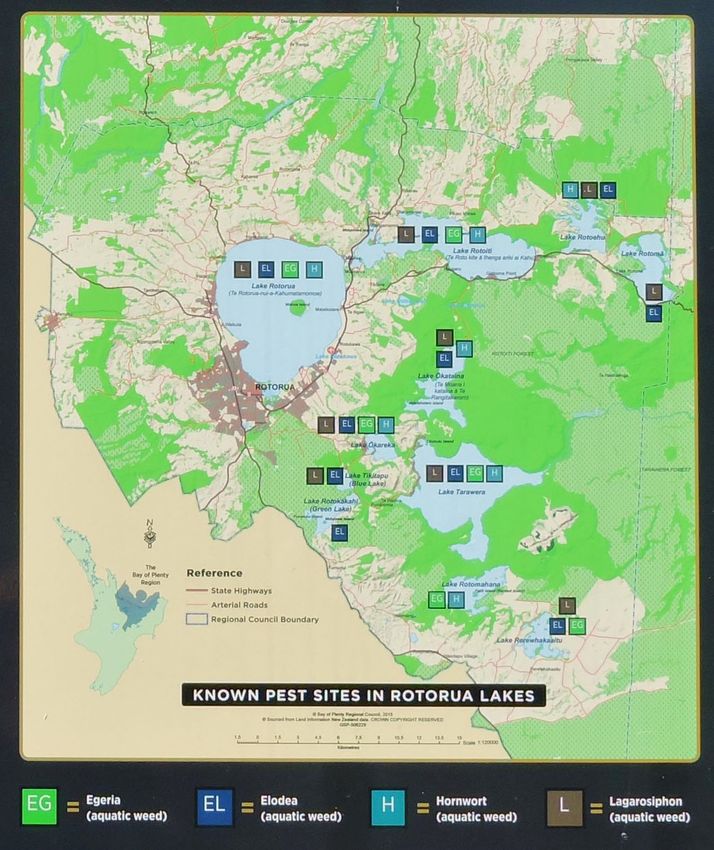
The Rotorua Lakes district in the Bay of Plenty has 16 lakes varying in size and
depth, all of which are currently under protective management for four invasive
macrophytes. These are; Ceratophyllum dermersum (Hornwort), Elodea canadensis
(Canadian Pondweed), Lagarosiphon major (Oxygen Weed), and Egeria densa
(Egeria) (Clayton, 1996). The distribution of these weeds across the 16 lakes varies
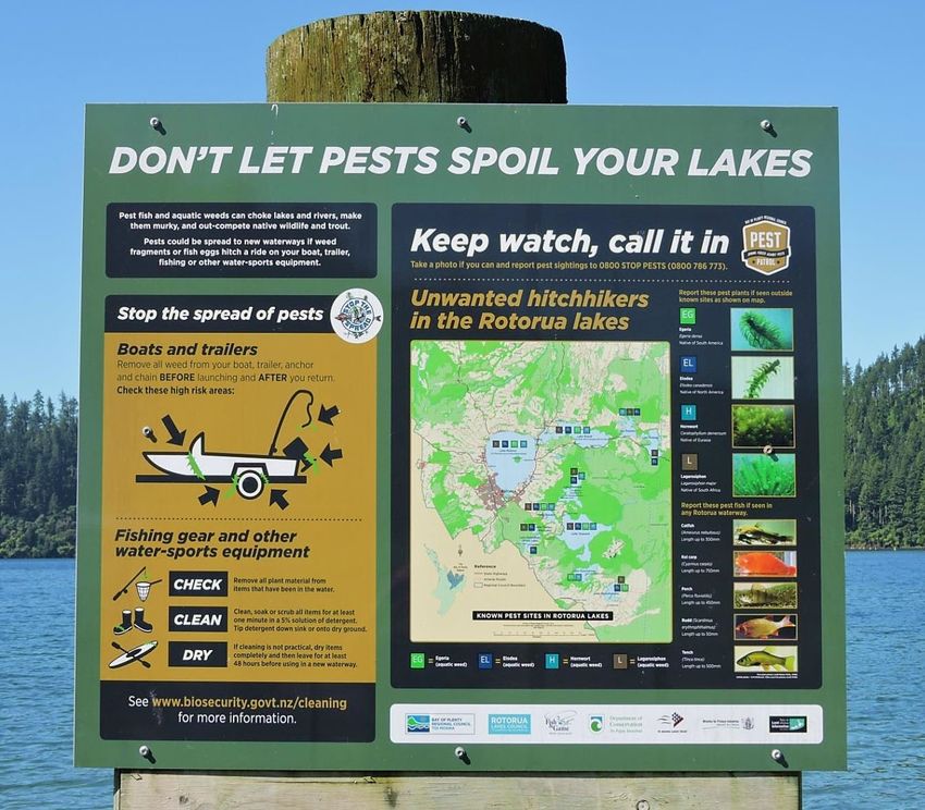
(see Appendix 1) as shown on the Aquatic Pest Coordination Group (APCG)
biosecurity signage posted at each of the lakes (see Appendix 2). Furthermore, the
close proximity of the lakes and the volumes of lake users that visit them make
them particularly susceptible to human assisted weed transfer.
Invasive weed species exhibit characteristics which allow them to out-compete
native species; spread rapidly and form dense aggregations in New Zealand’s
waterways. One of the reasons why they out-compete native plants is that as they
are exotic to New Zealand, lacking the presence of their natural predators or
grazers (Francis, 2012). Due to their ability to asexually reproduce via vegetative
fragmentation, weeds can be quickly distributed throughout recreationally used
waterways as a result of human activity.
The Aquatic Weed Risk Assessment Model (AWRAM) is a useful tool that predicts
the weed potential of a new species, by comparing the success of one aquatic
species with another. The ecology, biology, invasiveness and management of the
species (based on their behaviour in new habitats) are all compared. Each trait is
ranked on a scale of 0–100 and combined to give a total score (Table 1).
Table 1 Submerged aquatic plant species present in Rotorua lakes ranked
according to weed risk. Higher score reflects greater impact
(Champion & Clayton, Border Control for Potential Aquatic Weeds,
2000).
Common name Scientific name AWRAM score
Hornwort Ceratophyllum demersum 67
Egeria Egeria densa 64
Oxygen weed Lagarosiphon major 60
Canadian pondweed Elodea canadensis 46
6 Environmental Publication 2019/03 – Aquatic Pest Report 2019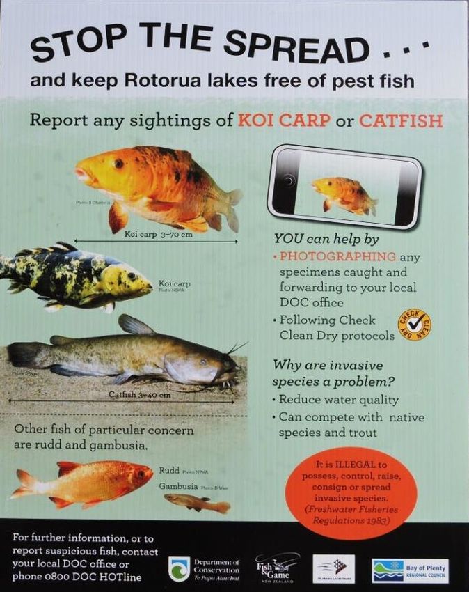
1.2.1   Hornwort

        Ceratophyllum demersum, commonly referred to as Hornwort, is a submerged
        freshwater macrophyte, which can occupy both shallow and deep littoral habitats
        (Pelechaty, Pronin & Pukacz, 2014). Hornwort is a unique macrophyte as it has the
        ability to inhabit low light environments and can dominate in eutrophic and turbid
        habitats (Pelechaty et al., 2014) (Keskinkan, Goksu, Basibuyuk & Foster, 2004).
        Hornwort can be classified by filiform leaves in whorls of (6-)8-10(-12), which are
        dichotomously branched with minute teeth which causes the plant to feel rough to
        the touch (Wilmot-Dear, 1985). Hornwort has no root structure (Les, 1991)
        however; it has modified leaves which anchor the plant in sediment (Keskinkan
        et al., 2004). The base if its stem is buried in sandy or silty substrates, however it is
        often found floating in stagnant, slow moving water (Syed, Fatima, Mohammed,
        Siddiqui, 2018). In clear lakes Hornwort can be found in depths of up to 16 m, and
        in dense beds which can reach up to 10 m in height, causing the inhibition of light
        penetration to native species (Wells, de Winton & Clayton, 1997) (Champion,
        Clayton & Rowe, 2002).

        Hornwort was first observed in the Bay of Plenty in 1975, in Lake Rotorua
        (Burton & Clayton, 2015) and has further established into Lakes, Rotoehu,
        Ōkataina, Rotoiti, Tarawera, Ōkāreka and Rotomahana. Lakes Ōkataina and
        Ōkāreka are under active control for Hornwort. Hornwort in Lake Ōkāreka is being
        controlled via an eradication program, which since August 2015 has yielded
        positive results, whereas Lake Ōkataina is being controlled by a weed cordon set
        across the arm of the lake, where Hornwort is commonly present. Hornwort is well
        established in the North Island, however it has been eradicated from the South
        Island of New Zealand. Due to the widespread establishment of Hornwort across
        the North Island it has caused detrimental effects on the environmental and
        recreational values within freshwater systems (Wells et al., 1997) (Champion et al.,
        2002). Due to Hornwort’s ability to float in slow moving water it often causes
        blockages on hydro-electric systems, costing the hydro-electric power industry
        millions of dollars in maintenance which is undertaken to prevent Hornwort
        blocking turbines (Coffey & Clayton, 1988).

        Hornwort has the ability to reproduce sexually and asexually, although the
        environmental requirements for sexual reproduction often limit seed production in
        many areas (Syed et al., 2018). Due to the rate and ease in which Hornwort can
        form a new plant via vegetative fragmentation it is considered a highly invasive
        weed species (Les, 1991) (Champion, Clayton & Rowe, 2002). Each fragment
        moving with the stem is capable of forming a new colony and are often
        dislodged from the parent plant as a result of wave action, currents, animals or
        propeller-driven boats (Coffey & Clayton, 1988) (Syed et al., 2018). As a result it is
        easily transported around the lake and can thrive in water of varying clarity,
        temperature, light and nutrient levels (Coffey & Clayton, 1988).

        The AWRAM scale gives Hornwort a score of 67, meaning it is a very high risk
        aquatic species. Under the Bay of Plenty Regional Pest Management Plan (RPMP),
        it is a containment pest that must not be moved or interfered with (Bay of Plenty
        Regional Council, 2016). Hornwort is also an unwanted organism under the
        Biosecurity Act 1993 and is banned from sale, propagation and distribution under
        the National Plant Pest Accord (Ministry for Primary Industries, 2016). As the
        Rotorua Lakes are highly vulnerable and Hornwort has a high potential to thrive in
        a number of varying habitats, it possesses a high risk to aquatic biosecurity in the
        Bay of Plenty.

BAY OF PLENTY REGIONAL COUNCIL TOI MOANA                                                         7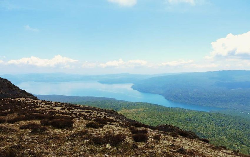
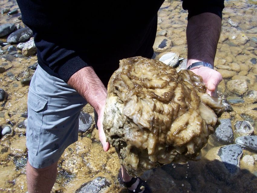
Figure 2     A boat trailer heavily infested with Hornwort after exiting
                     Lake Tarawera following a heavy storm.

1.2.2   Lagarosiphon

        Lagarosiphon major, (commonly known as oxygen weed), is a wholly submerged,
        vigorous freshwater perennial plant. Found to be present in all Rotorua lakes
        except lakes Rotomahana, Rotokakahi and Ōkaro, it is characterised by leaves that
        are strongly curved downward along the stem and arranged spirally (Champion,
        et al., 2013; Coffey & Clayton, 1988). Native to South Africa, the invasive weed has
        been present in New Zealand since the 1950s, presumably imported for use in the
        aquarium trade. It is now widely naturalised in the North Island, as well as the
        northern and eastern South Island.

        Lagarosiphon is known to inhabit clear, shallow water bodies with slow to
        moderately fast flow of water. They prosper in up to 6.5 m depth but may grow to
        1 m in murky water as well. As Lagarosiphon has sexes on different plants, only the
        female plant resides in New Zealand. Thus, it relies on human activity to facilitate
        its spread through fragmentation (Champion, et al., 2013; Coffey & Clayton, 1988).

        Once widespread, Lagarosiphon is extremely difficult to control, as it has the ability
        to form vast meadows, which shade out native species and prevents their seedlings
        from establishing. This can result in rotting vegetation, causing stagnant water and
        killing plants and animals. It also has an impact on recreational activities, as large
        clumps may become dislodged, blocking waterways and hydro-electric systems,
        causing flooding (Weedbusters, 2018). As a containment pest plant in the
        Bay of Plenty Regional Council Pest Management Plan, Lagarosiphon follows the
        same guidelines as Hornwort (Bay of Plenty Regional Council, 2016).

1.2.3   Egeria

        Egeria densa, commonly referred to as Egeria, is a freshwater perennial plant,
        native to South America. It is identified by short internodes and leaves which are
        approximately 10 mm-30 mm long, and 2 mm-5 mm wide (Champion & Hofstra,
        2013). Egeria forms dense monospecific strands, restricting water movement in
        stream environments, trapping sediment and causing water quality fluctuations
        (Champion & Tanner, 2000).

8                                  Environmental Publication 2019/03 – Aquatic Pest Report 2019
Egeria thrives in turbid, slow-flowing waters (de Winton, Champion, Clayton &
Wells, 2009), where its stems can grow to 5 m or until the plant reaches the water’s
surface. It then forms monospecific strands, reducing light penetration to other
organisms (Invasive Species Specialist Group (ISSG), 2006).
Egeria was introduced to New Zealand’s waterways via the aquarium trade
(de Winton et al., 2009) and was first found in Lake Rotorua in 1977. It has since
established in Lakes Ōkāreka, Rotoiti, Tarawera, Rerewhakaaitu and Rotomahana
(Wells & Clayton, 1991). It is widely distributed across most of the North Island and
is present in a small number of waterways in the South Island.
Egeria is difficult to properly manage and its dense growth creates anoxic
conditions which smother benthic communities. Due to Egeria’s dense growth it
can cause major impacts on hydroelectric dams, and has the ability to impede
irrigation flows and drainage within a catchment due to its growth habits
(Chapman, 1970). Listed as a containment pest plant under the Bay of Plenty
Regional Council Pest Management Plan, the Council would like to minimise its
effects and prevent its further spread (Bay of Plenty Regional Council, 2016).
1.2.4 Elodea
Elodea Canadensis, (commonly referred to as Canadian Pondweed), is a
submerged, bottom rooted, freshwater aquatic plant. Native to North America, it
has the ability to grow and multiply rapidly in a diverse range of environments and
conditions (Min et al., 2013). Elodea can be identified by its three leaves which are
arranged in whorls around the stem, similar in appearance to other oxygen weeds
(i.e. Lagarosiphon, Egeria). Elodea also flowers, in New Zealand this occurs in
November, December and January (Popay, Champion & James, 2010). The flowers
are carried to the surface by long, slender stalks for pollination via the wind and
water (Hulme, Nentwig, Pysek & Vila, 2010). Elodea forms dense mats over
substrate, often reaching heights of six metres (Popay et al., 2010), and thrives in
moderately fast-flowing to still water bodies.
Elodea was the first invasive weed introduced to New Zealand in 1868 (Champion,
Clayton & Rowe, 2002), presumably with the intention of oxygenating waters to
support future introduced species of fish (Champion et al., 2002). It is currently
present in all of the Rotorua lakes except for Lake Rotomahana. Dispersal and
reproduction of Elodea occurs by vegetative fragmentation, where the stem breaks
away from the parent plant and floats away. It then roots itself onto the substrate
and begins growing a new plant (Hulme et al., 2010). Fragments of Elodea have a
high survival rate, allowing for wide-spread dispersal, further increasing its invasion
capabilities (Barrat-Segretain, 2004). Human recreation activities are believed to be
one of the main dispersal methods for moving fragments, assisting in the dispersal
of Elodea (Barrat-Segretain, 2004).
Large growths of Elodea are responsible for many adverse economic and
ecological effects (Zehnsdorf, Hussner, Eismann, Ronicke & Melzer, 2015).
Economically, similar to Hornwort it has the capability to block hydroelectric dams
and restrict boat traffic (Zehnsdorf et al., 2015). Classed as a restricted pest plant
under the Bay of Plenty Regional Council Pest Plan, the council would like to
reduce the further spread of Elodea and support the community in doing so
(Bay of Plenty Regional Council, 2016). Ecologically it poses a major threat to
waterways due to its ability to modify the habitat it is present in, and the
competitive ability for light and space against other plant species (Champion el al.,
2002).
BAY OF PLENTY REGIONAL COUNCIL TOI MOANA 9Figure 3 Invasive weed species from left: Elodea canadensis, Ceratophyllum
demersum, Lagarosiphon major and Egeria densa. Taken at
Lake Aniwhenua.
1.2.5 Didymo
Didymo (Didymosphenia geminata) is a major threat to rivers both within
New Zealand and worldwide. A species of freshwater algae, didymo is a single
celled diatom that is microscopic, only having a noticeable presence when it
blooms. It is an aggressive invasive organism that is spread by humans, using as
little as a single drop of water, and has the ability to stay living when kept moist for
months at a time.
It is unusual for freshwater algae to dominate lotic water systems, even more so to
grow in nutrient-poor environments. Algae blooms are typically associated with
high concentrations in nutrients. Didymo however, appears to prefer water that is
low in phosphorus. A distinct characteristic of waterways low in nutrients is the
appearance of pristine, clean water. Therefore, didymo is a major threat to
New Zealand’s most beautiful waterways.
Didymo is able to form large mats when blooming, which consist of stalks that are
strong and decay resistant (Kilroy, Larned & Biggs, 2009). These are used to attach
to substrate such as rocks, forming thick colonies across large areas. The thick
brown layer smothers habitat for native plants and animals and is distinctly
recognised by its spongey texture, which appears slimy but rather feels gritty like
cotton wool.
10 Environmental Publication 2019/03 – Aquatic Pest Report 2019Didymo was first discovered in the South Island of New Zealand in 2004, in the
Waiau River, Southland. It is believed that the algae had already been present there
for 2-3 years, and was likely spread to New Zealand via human-related activities.
Prior to this, didymo was widely distributed but uncommon across the Northern
Hemisphere, but appeared to have more blooms in New Zealand, indicating that at
some point the algae transformed into a more common, aggressive species
(NIWA, 2014).
Although didymo is yet to be detected in North Island waterways, it is highly likely
that it has been spread at some stage and not established successfully. Now
present in 150 rivers in the South Island, it is one of the biggest threats of invasion
to the Bay of Plenty region. The lack of didymo in the North Island may be a result
of higher phosphorous levels; however didymo has been shown to grow
successfully in North Island waters using lab-based trials.
Classified under the regional pest management plan as a pest of national
significance, didymo is an unwanted organism under the Biosecurity Act (1993). In
order to prevent the spread of didymo, it is essential that any gear used between
waterways is cleaned and dried, especially as its presence is not visible to the
naked eye. The ‘Check, Clean, Dry’ programme by Biosecurity New Zealand
fundamentally targets the spread of didymo; however the guideline applies to all
freshwater pests.
Figure 4 A mass of didymo from a heavily infested South Island riverbed.
BAY OF PLENTY REGIONAL COUNCIL TOI MOANA 111.2.6 Lindavia intermedia
Lindavia intermedia is a free-floating diatom and is currently understood to have
arrived in New Zealand from North America, due to observations made in
New Zealand and American lakes (Novis et al., 2017). Recent reports have
recommended that no immediate action is to be taken to contain or eradicate
Lindavia, and therefore it is highly likely that Lindavia will establish as an invasive
organism in New Zealand’s lakes (Novis et al., 2017).
Lindavia poses no known human health risk, however it can pose a serious threat to
lake ecology and needs attention (Novis et al., 2017; Otago Regional Council,
2017). Commonly referred to as lake snow, colonies of Lindavia can produce a
sticky biological material, for reasons unknown (Horizons Regional Council, 2018;
Otago Regional Council, 2017). Further impacts of Lindavia on higher trophic levels
of the food chain are unknown and therefore options for management and public
awareness will need to be determined.
Lindavia is currently found in a number of Canterbury, Otago and North Island
lakes, such as Wakatipu, Wanaka, Hawea, Hayes, Taupō, Waikeremoiana and
Rotoaira (Horizons Regional Council, 2018). Water testing has shown Lindavia is
yet to establish in the Rotorua Lakes. More comprehensive testing is required, as it
is similar to didymo and is able to spread via a single drop of water. Once Lindavia
forms lake snow it has been shown to require upgrades to urban water
infrastructure, and has proven to be disruptive to recreational fishing on lakes
(Williams, 2017).
1.3 Pest fish
Freshwater pest fish species are less common in the Bay of Plenty region but pose
a serious threat to recreational waterways. Brown bullhead catfish, gambusia and
the common goldfish are currently present in the Rotorua lakes, whereas koi carp,
rudd, tench and perch have some presence in other areas of the Bay of Plenty or
surrounding North Island regions (Bay of Plenty Regional Council, 2018).
Pest fish were originally introduced to New Zealand for a variety of reasons,
including for biological controls, recreational fishing and ornamental purposes
(Collier, 2015). These invasive fish establish quickly and out-compete native
species for habitat and food. They are known to eat native fish and invertebrates,
as well as destroy habitat by disturbing the sediment, damaging river banks and
reducing water quality.
The presence of catfish in Lake Rotoiti is the most concerning invasion of pest fish
in the Rotorua Lakes District. Catfish and many other invasive fish species are only
spread to these areas via human activity. This may be accidental, such as catfish
swimming into boat trailers that are left in the water, or purposefully, such as koi
carp introduced to waterways as a food source.
1.3.1 Catfish
Brown Bullhead Catfish (Ameiurus nebulosus) are becoming an increasing
biosecurity threat to the Bay of Plenty region. Generally found in slow or still
waterways and the edge of lakes, they are highly adaptable to a variety of
environments including poor water quality, low oxygen levels and high
temperatures (Barnes & Hicks, 2003; Lakes Water Quality Society, 2017). Alongside
this, they have been known to survive out of the water for up to 48 hours. They are
recognized by four distinct pairs of barbels around their mouth, their dark brown
to olive-green colour and their thick, flattened body (Barnes & Hicks, 2003).
12 Environmental Publication 2019/03 – Aquatic Pest Report 2019Originally from North America, catfish were brought to New Zealand in 1877
as a food source and have since become abundant in various parts of the country,
including the Waikato river system and Lake Taupō (Grayling, 2018; Blair & Hicks,
2009). Alongside their ability to tolerate a variety of environments, catfish are one
of the few freshwater fish that exhibit parental care, defending juveniles in nests.
(Eycleshymer, 1901) This significantly increases their chances of survival,
facilitating their spread once introduced to a waterway. Catfish are generally
spread between waterways through recreational activities, as they are known to
hide inside boat trailers that are idle in the water for a period of time.
Once established, catfish cause detriment to natural lake environments in many
ways. They decrease water quality through sedimentation, by stirring up substrate
when feeding. Adults are omnivorous, feeding on fish, fish eggs, crustaceans,
molluscs, invertebrate larvae, detritus and more. This has led adult catfish to both
feed on koura (native freshwater crayfish) and compete with them for habitat
(Barnes & Hicks, 2003). They are also likely to compete with native eels, disrupt
macro invertebrate communities and alter ecosystem processes in our lakes
(Lakes Water Quality Society, 2017).
Thought to have been introduced to the Bay of Plenty region from Lake Taupō or
other Waikato waterways, catfish were initially found in 2016 at Lake Rotoiti, then
in Lake Rotorua in late 2018. As a result of this, significant measures have been
taken to prevent their spread to the remaining Rotorua lakes. Since their initial
discovery in Te Weta Bay, an aquatic pest cordon has been put in place as an
attempt to control the population. Although the majority of caught catfish have
been found in Te Weta Bay in Rotoiti (78%), populations have spread to many areas
around the lake, including Okere Inlet, Northern Shore and the Ōhau Channel
(Grayling, 2018). The extent to which populations have spread in Lake Rotorua is
yet to be determined. Classified as an exclusion or eradication pest in the
Bay of Plenty Regional Pest Management Plan, the known spread or sale of catfish
is prohibited under the Biosecurity Act (1993) and Freshwater Fisheries
Regulations (1983).
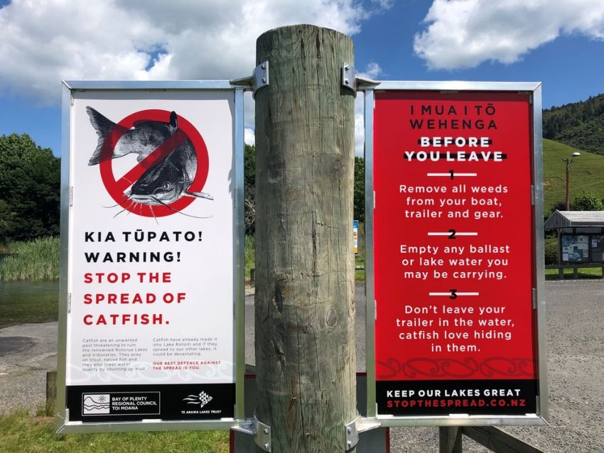
Figure 5 Catfish warning sign next to the boat ramp at Acacia Reserve,
Lake Ōkāreka.
BAY OF PLENTY REGIONAL COUNCIL TOI MOANA 131.3.2 Koi carp
Koi carp (Cyprinus carpio) are the most common pest fish in New Zealand
(Lakes Water Quality Society, 2017). Identified by their orange colour, they are
often mistaken with feral goldfish that can grow to similar sizes. Koi carp can grow
to lengths of 750 mm and can weight up to 10 kg. They are distinctly different to
goldfish, however, as they have two pairs of barbels on the side of the mouth. They
also exhibit blotching of different colours, including orange, red, black, gold and
white (Bay of Plenty Regional Council, 2018).
Introduced to New Zealand in the 1960’s, it is not known whether koi carp arrived
deliberately or by accident, but are thought to have been liberated from a pond to
a waterway in Te Awamutu. Now they are widespread and common throughout the
southern Waikato region and various ponds in the North Island. Like catfish, koi
carp generally prefer slow-moving or still freshwater environments and are spread
deliberately to waterways or private ponds, and can otherwise spread through
flooding events and via water channels.
Koi carp are omnivores and eat a variety of food including plants, invertebrates,
fish, larvae and detritus. They feed by vacuuming up benthic material and
discarding unwanted sediment, causing an increase of sedimentation into the
waterway, resulting in murky water and damaged riverbeds. In shallow lakes, they
have the ability to increase turbidity as they are constantly disturbing the
substrate. This causes unattractive waterways with poor water quality, and a
reduction in native aquatic plants. (NIWA, 2018.) Koi carp are listed as an
exclusion and eradication pest, indicating that the council is currently aimed at
excluding them or eradicating them from the region (Bay of Plenty Regional
Council, 2016).
1.3.3 Rudd
Scardinius erythrophthalmus, commonly known as Rudd belong to the cyprinid
family (Hicks, 2003) and are native to Europe and Central Asia. Rudd typically
prefer slow flowing water habitats and are able to tolerate a wide range of
temperatures (Hicks, 2003). They prey on a variety of invertebrates and vegetation,
due to their feeding habits they have the potential to alternative macrophyte
communities, aiding in the invasion of aquatic pest weeds (Lake, Hicks & Dugdale,
2002) (Hicks 2003).
Rudd was illegally introduced into New Zealand in 1967, where a private
consignment of juvenile Rudd were reared to adulthood and encouraged to breed
(Department of Conservation, 2017). One adult, the fish were strategically released
to a number of ponds in the Waikato region, however they have since spread to
the Northland, Manawatu, Canterbury and Nelson Regions (Department of
Conservation, 2017). Rudd are listed as a containment pest under the Bay of Plenty
Regional Council Pest Management Plan. This specifies that the council would like
to minimise the effects of and prevent their further spread. Land owners are
required to destroy all rudd in any pond or waterway, excluding Lake McLaren
(Bay of Plenty Regional Council, 2016).
14 Environmental Publication 2019/03 – Aquatic Pest Report 20191.3.4 Tench
Tinca commonly known as Tench belong to the cyprinid family (Rowe, 2004) and
are native to the United Kingdom. Tench are limited to slow-moving shallow water
habitats; however they are able to tolerate a wide variety of conditions. They have
a fleshy, downturned mouth with small barbels either side (NIWA, 2016) which
they use to prey on zooplankton and benthic invertebrates, and have been blamed
for a reduction in benthic invertebrates overseas (Rowe, 2004). Typically they have
bright red eyes and have an olive-green colour profile.
Tench were accidentally introduced into New Zealand in 1868, in addition to this
accidental introduction; they are also spread illegally to new bodies of water by
coarse fish angling enthusiasts (Carter, 2009). This illegal spreading of Tench is
often performed as when Tench are in bodies of water which lack large predators,
Tench have the ability to grow to unusually large sizes, making them attractive
targets to anglers from overseas. Tench are currently found in Christchurch,
Nelson, Oamaru, Northland and Tauranga (Dean, 2010), there have been
unconfirmed sightings in Lake McLaren (Bay of Plenty Regional Council, 2011).
There is strong evidence that Tench, when in large numbers, are responsible for
reducing lake clarity. They achieve this by disturbing the bottom sediments, and
increasing nutrient recycling in shallow lakes (Bay of Plenty Regional Council,
2012). This can also cause indirect negative effects on native fish species via
reduced food supply, reduction in water quality and reduced macrophyte cover.
Like Rudd, Tench are listed as a containment pest under the Bay of Plenty
Regional Council Pest Management Plan (Bay of Plenty Regional Council, 2016).
1.3.5 Gambusia
Gambusia affins, formally known as the mosquito fish, were supposedly introduced
into New Zealand’s waterways to control mosquitos (Ling, 2004), which
unfortunately they do not. Gambusia are found most abundantly in shallow water,
where they are protected from larger fish (Kuntz, 1913). They are also well adapted
to living in hostile environments, are resilient to low oxygen concentrations and are
able to survive in temperatures up to 42°C for short periods (GISD, 2010).
Gambusia are aggressive and often attack native fish species by nipping at their
fins and eyes, they also compete with native fish for food and have been observed
eating native fish eggs.
Gambusia were first released in the Auckland Botanical Gardens pond in the
1930’s (Department of Conservation, 2017). Further transfers into Northland,
Taranaki and Wellington in the late 1930’s are also documented (Department of
Conservation, 2017). Since the 1930’s, Gambusia have spread dramatically into the
North Island’s waterways due to natural spread, and by further illegal introductions.
Following successful eradication operations, there are no known populations of
Gambuisa in the South Island (NIWA, 2018).
1.3.6 Pest Management in the Bay of Plenty
The Bay of Plenty Regional Pest Management Plan (2011-2016) outlines what we as
a Council are trying to achieve through our efforts to manage and prevent pest
plants and animals. The plan also provides an outline of the statutory obligations
surrounding various pests depending on their classification (Bay of Plenty
Regional Council, 2011).
BAY OF PLENTY REGIONAL COUNCIL TOI MOANA 15There are four classifications of pests in the Bay of Plenty, (Table 2). Each
classification has its own specific objectives, rules and statutory obligations for the
management of the pests. All freshwater pests, regardless, are protected under
sections 52 and 53 of the Biosecurity Act 1993. This states that no person shall
willingly sell, release or otherwise facilitate the spread of such species (Ministry of
Agriculture and Forestry, 1993).
Table 2 Definitions and examples of pest classifications as stated in the
Bay of Plenty Regional Pest Management Plan (2011).
Classification Description Examples
Agency Pests Pests of national significance that Didymo.
are managed by or subject to
programmes coordinated by the
Crown.
Pests we want to prevent from Brown bullhead catfish,
Exclusion and
entering the region, or eradicate koi carp.
Eradication Pests
from the region.
Pests that we want to minimise the Hornwort, lagarosiphon,
Containment Pests effects of and prevent their further egeria, rudd, tench.
spread.
Pests we want to reduce the Elodea, gambusia.
further spread of and will support
Restricted Pests community and occupier efforts to
control, in places where they are a
problem.
The rules surrounding both containment pests and exclusion and eradication pests,
also specify that, “No person shall move or allow to be moved, any machinery,
vessel, organism, risk goods or other goods that is contaminated with any pest
animal” (Bay of Plenty Regional Council, 2011). This is especially important due to
the nature of these aquatic weed and fish pest species to be facilitated by the use
of boats, boat trailers and other recreational equipment.
1.4 Awareness programme and survey background
The Bay of Plenty region’s lakes and waterways are used by many residents, as well
as domestic and international visitors. The waterways are used for a variety of
recreational activities with a range of different equipment such as clothing, vessels
and trailers entering the water. This equipment has been identified as the primary
vectors capable of transferring invasive weed, fish and algae between water bodies
around New Zealand.
Since the introduction of didymo to the South Island, several groups have been
established to manage at-risk waterways and improve public awareness of
freshwater pests. The Aquatic Pest Coordination Group (APCG) was established in
2004 and is made up of the Department of Conservation (DOC), Eastern Fish and
Game, Bay of Plenty Regional Council (BOPRC), Te Arawa Lakes Trust, Land
Information New Zealand (LINZ) and the Rotorua Lakes Council (RLC). These
organisations work in partnership in regards to their role in preventing the dispersal
of aquatic pests.
16 Environmental Publication 2019/03 – Aquatic Pest Report 2019In July 2007, the didymo Long-Term Management Plan (LTM) was implemented
across New Zealand, consisting of partnerships between MPI (Formerly MAF: the
Ministry of Agriculture and Forestry), DOC, Fish and Game New Zealand, regional
councils, impacted industry and iwi. The LTM outlined objectives, roles and
responsibilities for didymo management. The Rotorua Te Arawa Lakes Programme
was also established in 2015, and is comprised of the Te Arawa Lakes Trust, RLC
and the BOPRC. The purpose of this programme is to ‘work together to protect
and restore water quality in 12 Rotorua lakes’ (Te Arawa Lakes Programme, 2015).
More recently in 2016, MPI established the Freshwater Biosecurity Partnership
Programme (FBPP). Formally the LTM programme, the FBPP is a long-term
strategy extending through to 2021. It brings together the partners as listed above,
as well as the addition of local iwi, Genesis Energy and Meridian Energy. The
programme recognises the extension by the LTM to include all freshwater pests in
2011 and provides support and coordination for the APCG group.
Since the forming of the APCG in 2004, the Bay of Plenty Regional Council, with
support from MPI, has employed two tertiary students over the busy summer
period each year. The primary role for the students is to assist with the Aquatic
Pest Advocacy Programme (APAP), a BOPRC initiative. Over previous years, a
survey created for the APCG was conducted, in order determine pest awareness
among the general public. Since 2017, a new MPI survey designed as a part of the
National Science Challenge is being conducted nationwide (Appendix 3).
1.5 Aims and objectives
The aim of the Aquatic Pest Advocacy Programme is to raise awareness within the
community and educate the public about preventing the spread of aquatic pests.
This programme is specifically targeted at recreational users of Rotorua’s
waterways, both local and visiting. Emphasis is placed on ways in which the public
can help minimise the spread of aquatic weed and fish species both within the
Bay of Plenty region and beyond.
Data collected over the 2018/2019 summer period via electronic surveys will be
used to determine the level of freshwater biosecurity knowledge by water users, as
well as what they are currently doing to help prevent pests. This is important as it
will allow for us to target future awareness programmes towards the types of users
who appear to need it most. Various education material and merchandise supplied
by the Ministry for Primary Industries and the Bay of Plenty Regional Council is also
used to help capture public interest and spread knowledge throughout the
community. This report will summarise the findings of the electronic survey, the
efforts made through public interactions and what recommendations can be made
as a result.
BAY OF PLENTY REGIONAL COUNCIL TOI MOANA 17Part 2:
Methods
Between 20 December and 19 January, a total of 673 surveys were completed across the
Bay of Plenty, with the vast majority conducted around the Rotorua Lakes. Lakes
Rotomahana and Rotokakahi are privately owned, therefore were not visited.
The surveying schedule was conducted around aquatic events and during times when the
water bodies would have peak volumes of users. Typically this was during public holidays
and on weekends. Each survey period was eight hours long and occurred predominantly
every weekend and three days a week, depending on weather conditions and user
numbers.
Over the course of the summer, the BOPRC portable boat wash station was operational for
nine days during public holidays and weekends. The aim was to clean vessels as they were
entering or leaving the lake, and to engaging with vessel owners regarding the need to
wash vessels between waterways. The boat wash provides a high pressured wash which
removes loose weed fragments from boats and trailers.
Additionally to surveys, educational collateral material was distributed to; relevant retail
outlets, information sites, tourism and accommodation providers. Aquatic event organisers
were also contacted, and were provided with educational collateral material, information
and decontamination equipment where required.
2.1 Waterway surveys
Boat ramps, lake and river side locations around the Bay of Plenty were visited
multiple times during the busy period over summer. The Rotorua Lakes were
divided into the Northern Lakes, Central Lakes, and Southern Lakes, each region
was typically visited on alternating days, however if user population was low,
multiple regions were visited a day.
Waterway users were observed and approached predominantly whilst they
appeared to have a few minutes to spare, on boat ramps this was whilst they were
in queue for the ramp. The waterway users were asked a series of questions in
accordance with the National Science Challenge Survey, questions asked included:
Waterway name.
Location where the survey took place.
User type.
Country, region of residence and nearest town.
Frequency of waterway visits.
Freshwater pest plant and/or algae knowledge.
Whether freshwater pest plants and/or algae had impacted waterway
enjoyment.
Methods for cleaning vessels and equipment used in freshwater.
Water bodies visited in the last two weeks (prior to survey).
Provide contact details for a follow up.
18 Environmental Publication 2019/03 – Aquatic Pest Report 2019User knowledge of freshwater pest plants locally and nationally was gauged by
asking users to identify aquatic pest plant species which are currently an issue in
the Bay of Plenty and species which are outside of the region. The aquatic pest
plants included in the survey included; Didymo, Hornwort, Egeria, Lagarosiphon,
Lake Snow and Hydrilla.
Depending on the information collected, users were then informed on current
aquatic pest issues, typically in the Bay of Plenty region and how to prevent the
spread of aquatic pests. Education and information was tailored to the waterway
user, i.e. boat/jetski owners were spoken to about weed transfer via trailer and
fishermen about pest fish species.
Once a survey was completed a promotional pack containing further information
was presented to the waterway user as a thank-you for participating, along with a
practical use. The promotional packs were tailored for different waterway users,
i.e. swimmers would be given a swim bag with a floatable keyring, bumper sticker,
‘Check, Clean, Dry’ material, and sunglasses strap, whereas a boat user/fisherman
would be given a trout bag, floatable keyring, ‘Check, Clean, Dry’ material,
sunglasses strap, fly holder and trout measuring ruler.
Surveys were conducted via iPad and mobile phone, all information gathered was
uploaded to a central server (ArcGIS), which was collated and analysed.
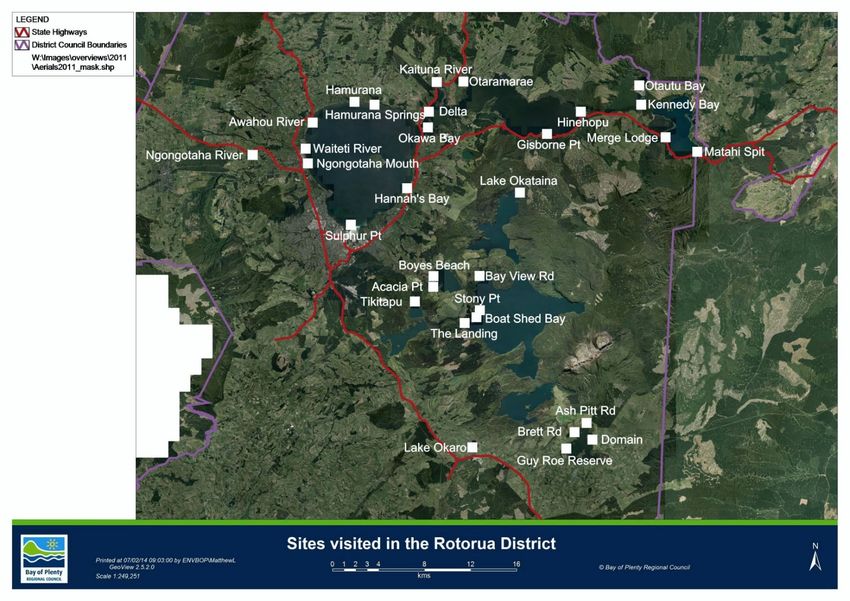
Sites visited over the duration of the Summer Aquatic Pest Awareness Program are
as follows; see Appendix 6 for map locations of these sites.
Table 3 Survey locations for the 2018/2019 summer period.
Northern sites Central sites
Lake Rotorua Lake Rotorua
Awahou River Waitetī River
Hamurana Sulphur Point
Hamurana Springs Hannahs Bay
Lake Rotoiti Holdens Bay
Otaramarae Lake Okareka
Delta Ramp Boyes Beach
Okawa Bay Acacia Point
Gisborne Point DoC Campground
Hinehopu Point Lake Tarawera
Lake Rotoehu Bay View Road
Kennedy Bay Stoney Point
Ōtautū Bay Boatshed Bay
Lake Rotoma The Landing
Merge Lodge Lake Tikitapu
Matahī Spit
Lake Rotoma
BAY OF PLENTY REGIONAL COUNCIL TOI MOANA 19Southern sites River sites
Lake Ōkaro Rotorua
Lake Rerewhakaaitu Kaituna River
Guy Roe Reserve Hamarana
Brett Road (DoC Campground) Ngongotahā River
Ash Pitt Road (DoC Campground) Ngongotahā River Mouth
Tauranga
Wairoa River
Whakatane
Whakatāne River
2.2 Boat wash surveys
The Bay of Plenty Regional Council provided a portable boat wash station that was
set up at five popular boat ramps during the 2018/2019 summer period. The wash
uses water from the lake combined with simple green detergent to spray vessels
from the sides and underneath, while they are driven over a ramp. The purpose of
this is to ensure weed is removed from vessels and their trailers before they are
taken to another waterway.
Boat wash users, as well as non-users who were interested, were asked to
participate in a survey about freshwater aquatic pests. The survey included
information about the vessel type, owner residence and previous water source, as
well as the following yes/no questions:
Do you know about aquatic pests/fish?
Do you clean your vessel prior to changing water sources?
Aquatic weeds found on vessel?
The sites where the boat wash was set up included Boat Shed Bay
(Lake Tarawera), Matahī Spit (Lake Rotomā), Rotoiti Delta (Lake Rotoiti),
Acacia Reserve (Lake Ōkāreka) and Lake Tikitapu. These sites were chosen due to
spatial constraints, as the boat wash station was able to be set up without
impeding on lake users accessibility. Weather was also a determining factor.
20 Environmental Publication 2019/03 – Aquatic Pest Report 2019Figure 6 The boat wash in use at Lake Tikitapu for the 2018 FLOCHELLA event.
2.3 Retail and tourism awareness
Each year, millions of visitors are attracted to the Bay of Plenty region for its
diverse range of freshwater activities. As a result of this, dozens of businesses are
set up as retail and tourism outlets for outdoor/adventure based activities. These
businesses are in turn tasked with helping to inform the public about their roles
and responsibilities in regards to biosecurity. Between 19 November 2018 and
8 February 2019, 83 outlets were visited within the Bay of Plenty region, including
Rotorua, Tauranga, Whakatāne and Ōpōtiki (Appendix 5).
In order to ensure that we were targeting waterway users, various accommodation
sites including campgrounds, holiday parks and motor inns were visited, as well as
stores that supplied boating and fishing gear. Tourist attractions were also visited
alongside some popular cafes amongst lake users.
Various promotional materials were supplied to retail outlets depending on their
target customers. Fishing and outdoor stores were supplied with Check, Clean, Dry
brochures, spray bottles and detergent, as well as fish measuring stickers and fly
fishing containers. Holiday parks, motor inns and campgrounds were given spray
bottles and detergent, as well as brochures and keychains to distribute to guests.
Tourism outlets were given information brochures, and cafes were given catfish
coffee cups, t-shirts, brochures and various other small items such as lanyards.
Where possible, managers and supervisors were spoken to, which ensured that the
correct message was being spread to customers.
Merchandise was supplied by both the Ministry for Primary Industries and the
Bay of Plenty Regional Council. The messages included were in relation to the
‘Check, Clean, Dry’ (CCD), campaign and ‘Stop the Spread’ of both aquatic weeds
and catfish (Appendix 4). The CCD campaign messages focused on reducing the
further spread of aquatic weeds as well as preventing didymo from entering the
North Island. The catfish messages focused on ‘Make our Lakes Great’ and included
steps on how to prevent the spread of catfish.
BAY OF PLENTY REGIONAL COUNCIL TOI MOANA 212.4 Event and school awareness
Water based events in the Bay of Plenty region provided the pest advocates an
opportunity to engage with a wider audience, maximising aquatic pest awareness.
Each event catered to groups with a diverse range of interests across the country.
Events provided an opportunity for the aquatic pest advocates distributing
information to organisers and collecting surveys from the event participants.
As with previous years, the focus was on event organisers to take the initiative and
control of the decontamination process. As part of the lake closure consents for
events, organisers and participants must read and abide by the biosecurity
protocol (Appendix 7), in order to take part in the Bay of Plenty’s waterway
events.
Events held during the 2018/2019 summer period in the Bay of Plenty region were
(events attended are labelled with an asterisk).
Blue Lake Kayak Regatta, Lake Tikitapu.
*New Zealand Water Ski Racing, Lake Rotomā.
Jet Ski racing, Lake Rotorua.
*Fish and Game Boat Fishing Seminar, Lake Tarawera.
*Dewar Shield Blue Lake Regatta, Lake Tikitapu.
Rotorua Half Iron Man, Lake Tikitapu.
Advocates also attended three outings with the Rotorua Duck Tours this summer
period. Advocates went with school groups from Lynmore Primary School on the
Duck to lakes Ōkāreka and Tikitapu, informing the students and their teachers the
importance of freshwater biosecurity and the current pests we have in the
Bay of Plenty. A game was played with the students where laminated pictures of
pest fish and weeds in New Zealand were placed around the Duck and the students
had to pick them off, simulating what needs to be done when exiting waterways.
Figure 7 Advocates Thomas Bailey and Freya Ewing at the Dewar Shield
Blue Lake Regatta.
22 Environmental Publication 2019/03 – Aquatic Pest Report 2019Part 3:
Results
3.1 Lake surveys
3.1.1 Distribution of surveys conducted at lakes
Nine of the Rotorua Lakes were surveyed over the summer period. The majority of
users were surveyed at Lakes Tarawera, Tikitapu and Rotoiti (Figure 8). Of these
locations, lakes Tarawera, Rotoiti, Rotomā, Ōkāreka, Rerewhakaaitu and Rotorua
had multiple survey sites.
30 29
Percentage of users surveyed (%)
25
25
20 17
15
10 9
10
5 3 2
0.9 0.1
0
Location of Survey
Figure 8 Distribution of surveys conducted at different lakes within the
Bay of Plenty region.
3.1.2 Distribution of surveys conducted at rivers
Two river sites in the Bay of Plenty region were surveyed over the 2018/2019
summer period. Of those who were surveyed at a river, 67% were located at the
Wairoa River and 33% at the Kaituna River (Figure 9).
BAY OF PLENTY REGIONAL COUNCIL TOI MOANA 2370 67
Percentage of users surveyed (%)
60
50
40 33
30
20
10
0
Wairoa River Kaituna River
Location of survey
Figure 9 Distribution of surveys conducted at different rivers within the
Bay of Plenty region.
3.1.3 Waterbody user type
A total of 12 different user types were recorded over the 2018/2019 summer
period. Vessel users such as boat fishers, kayakers, rowers and water skiers
comprised over half of those surveyed (Figure 10). Swimmers alone, however,
comprised over a quarter (Figure 10).
30 29
26
Percentage of users surveyed (%)
25
20
15 13
9 8
10
4 3 3 3
5 1 0.4 0.1
0
Waterbody user type
Figure 10 Percentage of waterbody user types surveyed at different lakes and
rivers within the Bay of Plenty region.
24 Environmental Publication 2019/03 – Aquatic Pest Report 20193.1.4 Origin of users
A significantly high proportion of users surveyed originated from the Bay of Plenty
region (Figure 11). Alongside this, over 95% of all users surveyed are from within
the North Island (Figure 11).
70
Percentage of users surveyed (%)
59
60
50
40
30
17
20
10
10 4 3 2 2 1 0.7 0.6 0.3 0.3
0
Region of origin of all users surveyed
Figure 11 District/region of origin of all users surveyed.
3.1.5 Region/type of last water body used
Of the 672 users surveyed, 168 did not use any waterway in the last two weeks
(Figure 12). 20% of users entered a marine waterway and the remaining users had
entered a waterway in the Bay of Plenty or Waikato regions (Figure 12).
Percentage of users surveyed (%)
40
33
30
25
20
20 16
10
2 1 1 1 0.3 0.3 0.1 0.1
0
Region of waterway used
Figure 12 Region of last water body used by those surveyed.
BAY OF PLENTY REGIONAL COUNCIL TOI MOANA 253.1.6 Knowledge of freshwater pest plants
A relatively low number of waterway users had any knowledge of aquatic pest
plants (49%), (Figure 13). The majority of users who were aware of pests however,
knew of didymo/rock snot and nothing else (Figure 13).
Percentage of users surveyed (%)
40 35
30
20
9
10
4
1 1 0.1
0
Freshwater pest plant type
Figure 13 Knowledge of freshwater pest plants by all users surveyed.
3.1.7 Pest plant impact on enjoyment
Regardless of freshwater pest plant knowledge, the majority of users reported that
pest plants do not impact on their enjoyment of waterways in New Zealand
(Figure 14).
28%
Yes
No
72%
Figure 14 Percentage of all users who claim aquatic pest plants impact on their
enjoyment of New Zealand waterways.
26 Environmental Publication 2019/03 – Aquatic Pest Report 20193.1.8 Users who Check, Clean, Dry vessels/equipment
Of the 672 users surveyed, 69% took action in the form of Check, Clean, Dry, to
prevent the spread of freshwater pests (Figure 15). Of these users, the majority
either cleaned their gear, or checked and cleaned it. Very few users followed the
Check, Clean and Dry procedure correctly (Figure 15). Alongside this, 19% didn’t
take any action to prevent the spread, and 12% were not applicable as they did not
move between waterways.
250
207
Number of users surveyed
196
200
150
100
50 41
19
0
Check Clean Check, Clean Check, Clean, Dry
Cleaning technique
Figure 15 Cleaning methods used by those surveyed to prevent the spread of
pests.
3.2 Boat wash survey
3.2.1 Distribution of surveys conducted at lake sites
Boat Shed Bay at Lake Tarawera and Matahī Spit at Lake Rotomā are both large
boat ramps and were where the most boat wash surveys were conducted
(Figure 16). Boat Shed Bay, Matahī Spit and Acacia Reserve were also all surveyed
on more than one occasion.
100
Number of users surveyed
81
80
61
60
40 33
20 13 9
0
Boat Shed Matahī Spit Acacia Rotoiti Delta Tikitapu
Bay Reserve
Boat Ramp
Figure 16 Distribution of surveys conducted at Boat Shed Bay (Lake Tarawera),
Matahī Spit (Lake Rotomā), Acacia Reserve (Lake Ōkāreka), Rotoiti
Delta (Lake Rotoiti) and Lake Tikitapu.
BAY OF PLENTY REGIONAL COUNCIL TOI MOANA 273.2.2 Origin of owners
The majority of vessel owners surveyed at the boat wash were originally from the
Bay of Plenty region. Rotorua and Tauranga users were particularly common
(Figure 17).
50
Percentage of users surveyed (%)
39
40
30 28
20
11
9
10 6
3 2 1 1 1 1
0
District/region of users origin
Figure 17 District/region of origin of users surveyed.
3.2.3 Vessel type
There were three vessel types surveyed at the boat wash over the 2018/2019
summer period. 75% of all users surveyed had a boat, however almost a quarter of
users had a jet ski and a small proportion had a kayak (Figure 18).
80 75
Percentage of users surveyed (%)
60
40
23
20
2
0
Boat Jet Ski Kayak
Vessel Type
Figure 18 Percentage of different vessel types that were surveyed.
28 Environmental Publication 2019/03 – Aquatic Pest Report 20193.2.4 Last waterbody used
Previous water bodies used by those surveyed at the boat wash were all in the
Bay of Plenty or Waikato regions (Figure 19). However, the majority of users had
last entered the ocean as opposed to a waterway (Figure 19).
30
Percentage of users surveyed (%)
25
25
22
19
20
15
10
10 8
4 4 4 4
5 2 1 1
0
Last waterbody used
Figure 19 Most recent water source used by those surveyed.
3.2.5 Use of Boat Wash
Of the users surveyed at the boat wash, only 45% participated in using it to clean
their vessel (Figure 20).
45% Yes
No
55%
Figure 20 Percentage of users surveyed who used the boat wash.
BAY OF PLENTY REGIONAL COUNCIL TOI MOANA 29You can also read