The Mw 8.8 Chile Earthquake of February 27, 2010
←
→
Page content transcription
If your browser does not render page correctly, please read the page content below
EERI Special Earthquake Report — June 2010

Learning from Earthquakes

The Mw 8.8 Chile Earthquake of February 27, 2010
From March 6th to April 13th, 2010,     mated to have experienced intensity        ies of the gap, overlapping extensive
a team organized by EERI investi-       VII or stronger shaking, about 72%         zones already ruptured in 1985 and
gated the effects of the Chile earth-   of the total population of the country,    1960. In the first month following the
quake. The team was assisted lo-        including five of Chile’s ten largest      main shock, there were 1300 after-
cally by professors and students of     cities (USGS PAGER).                       shocks of Mw 4 or greater, with 19 in
the Pontificia Universidad Católi-                                                 the range Mw 6.0-6.9.
                                        As of May 2010, the number of con-
ca de Chile, the Universidad de
                                        firmed deaths stood at 521, with 56
Chile, and the Universidad Técni-                                                  Tectonic Setting and
                                        persons still missing (Ministry of In-
ca Federico Santa María. GEER                                                      Geologic Aspects
                                        terior, 2010). The earthquake and
(Geo-engineering Extreme Events
                                        tsunami destroyed over 81,000 dwell-       South-central Chile is a seismically
Reconnaissance) contributed geo-
                                        ing units and caused major damage to       active area with a convergence of
sciences, geology, and geotechni-
                                        another 109,000 (Ministry of Housing       nearly 70 mm/yr, almost twice that
cal engineering findings. The Tech-
                                        and Urban Development, 2010). Ac-          of the Cascadia subduction zone.
nical Council on Lifeline Earthquake
                                        cording to unconfirmed estimates, 50       Large-magnitude earthquakes
Engineering (TCLEE) contributed a
                                        multi-story reinforced concrete build-     struck along the 1500 km-long
report based on its reconnaissance
                                        ings were severely damaged, and            coastline in 1835, 1906, 1928, 1960,
of April 10-17. A complete list of
                                        four collapsed partially or totally. The   1985, and 2010 (Cisternas et al.,
team members begins on page 19.
                                        earthquake caused damage to high-          2005). Tectonic deformation result-
The research, publication, and dis-     ways, railroads, ports, and airports       ing from the February 27th quake
tribution of this report were funded    due to ground shaking and liquefac-        played a substantial role in the ob-
by the EERI Learning from Earth-        tion. The earthquake was followed          served damage. Ground shaking
quakes project, under grant #CMMI-      by a blackout that affected most of        and surface effects were observed
0758529 from the National Science       the population, with power outages
Foundation. Additional support was      affecting selected regions for
provided by the Pacific Earthquake      days. Estimates of economic
Engineering Research Center, Fed-       damage are around $30 billion.
eral Highway Administration, Ameri-
                                        According to the USGS (2010),
can Society of Civil Engineers, and
                                        the earthquake epicenter was
the host organizations of participat-
                                        in a zone where the Nazca
ing individuals.
                                        plate is being subducted down-
                                        ward and eastward beneath
Introduction                            the South American plate. The
On Saturday, February 27, 2010,         earthquake occurred as thrust
at 03:34 a.m. local time (06:34:14      faulting on the interface be-
UTC), an Mw 8.8 earthquake struck       tween the two plates, with
the central south region of Chile,      an epicenter at 35.909°S,
affecting an area with a population     72.733°W (just off the coast
exceeding eight million people, in-     105 km NNE of Concepción)
cluding 6.1M, 0.8M, and 0.9M in the     and a focal depth of 35 km.
urban areas around Santiago, Val-       The estimated dimensions of
paraíso/Viña del Mar, and Concep-       the rupture zone were 500 km
ción, respectively. Figure 1 shows      long by 100 km wide. The
the location of the main shock and      earthquake struck in an area
aftershocks relative to major cities.   that had been identified as a
In the region of strongest ground       seismic gap, with projected
shaking, ground accelerations           worst case potential to produce
exceeded 0.05g for over 120 s.          an earthquake of Mw 8.0-8.5
Coastal locations were affected by      (Ruegg et al., 2009). The rup-      Figure 1. Main shock and aftershocks of
both ground shaking and tsunami.        ture zone extended beyond the       Mw 4 and larger between 2/27/10 and
Over 12 million people were esti-       northern and southern boundar-      3/26/10 (USGS).

                                                           1
EERI Special Earthquake Report — June 2010

                                                                                         resulted in drowned tidal flats and
                                                                                         local areas of significant tsunami
                                                                                         erosion. To the north, from about
                                                                                         the town of Pichilemu to Valparaíso,
                                                                                         there was little or no obvious uplift/
                                                                                         subsidence. The areas of coastal
                                                                                         subsidence were exposed to sub-
                                                                                         stantial tsunami runup and scour,
                                                                                         as well as wave damage, whereas
                                                                                         areas of substantial uplift generally
                                                                                         had relatively little damage from
                                                                                         tsunami waves. However, in coastal
                                                                                         areas close to the epicenter with
                                                                                         only moderate uplift (e.g., Concep-
                                                                                         ción and Dichato), there was sub-
                                                                                         stantial damage related to both
                                                                                         strong ground motions and tsunami
                                                                                         runup.

                                                                                         Strong Motion
                                                                                         The main shock of the earthquake
                                                                                         was recorded by at least 15 strong
                                                                                         motion instruments in the area
        Figure 2. Model of estimated surface deformation (after K. Wang,                 bounded by the cities of Santiago,
        2010, personal communication), overlain by initial field estimates               Viña del Mar, Angol, and Concep-
        of coastal uplift (GEER, 2010).                                                  ción. At the station nearest to the
                                                                                         epicenter, Cauquenes city, the accel-
  over an area more than 100 km              uplift affected harbor facilities (Figure   erometer maximum 1g range was
  wide and 600 km long, from Val-            3), produced an emergent marine             exceeded. Several of the recording
  paraíso in the north to Tirúa in the       platform, and exposed the tidal habitat     instruments are analog, so process-
  south. This is equivalent to the           zone. In the central part of the rup-       ing is slow and still underway. Some
  entire coastline of Washington and         ture zone, coastal subsidence over a        of the digital instruments have been
  Oregon.                                    distance of about 50 km between the         processed and reported in Boro-
                                             towns of Constitución and Bucalemu          schek et al. (2010) and National
  In south-central Chile, regional geo-
  logic characteristics are largely con-
  trolled by long-term aseismic surface
  deformation, punctuated by sudden,
  coseismic coastal uplift and inland
  subsidence. These influence the
  pattern of ground motions and tsu-
  nami runup, and hence earthquake
  damage. The February 27 earth-
  quake produced both uplift and sub-
  sidence along the coastline (Figure
  2), and the variable pattern of defor-
  mation may have affected tsunami
  impacts on coastal communities.
  Reconnaissance-based estimates
  of deformation (GEER, 2010) sup-
  port initial models of surface defor-
  mation. In the south, the Arauco
  Peninsula was uplifted and tilted
  gently eastward, with at least 2 m
  of coastal uplift on Isla Santa Maria
  and near the town of Lebu. The             Figure 3. Fishing boats stranded within uplifted harbor of Lebu; uplift of
                                             1.8 +/- 0.2 m in this area (photo: GEER, 2010).

                                                                 2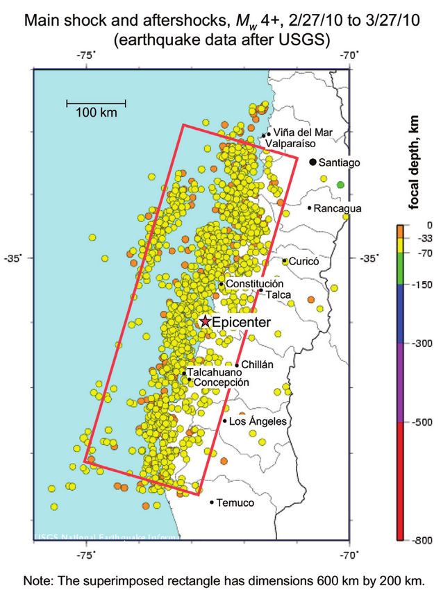
EERI Special Earthquake Report — June 2010

    Table 1. Preliminary Processed Records Maximum Accelerations                        of the damaged structures there.
                (from Boroschek et al., 2010 and DGF 2010)                              The cities of Viña del Mar and
                         Station                      Maximum        Maximum            Talca, founded on marine and al-
                                                      Horizontal      Vertical          luvial deposits, suffered extensive
                                                     Acceleration   Acceleration        damage during the earthquake.
                                                         (g)            (g)
                                                                                        Concepción is founded on a sedi-
        Santiago Universidad de Chile                   0.17           0.14
        Santiago Elevated Train Station Mirador         0.24           0.13             mentary valley, and the extensive
        Santiago CRS MAIPU                              0.56           0.24             damage there was associated with
        Santiago Hosp. Tisne                            0.30           0.28             site or basin effects. Among seven
        Santiago Hosp. Sotero de R’o                    0.27           0.13             distinct zones in the city where
        Santiago Cerro Cal‡n                            0.23           0.11
                                                                                        buildings or bridges collapsed cata-
        Santiago Campus Antumapu                        0.27           0.17
        El Roble Hill                                   0.19           0.11             strophically, six were parallel to the
        Vi–a del Mar (Marga Marga)                      0.35           0.26             La Pólvora fault, which defines the
        Vi–a del Mar (Downtown)                         0.33           0.19             northwest edge of the basin.
        Curico Hospital                                 0.47           0.20
        Concepci—n Colegio San Pedro                    0.65           0.58             Buildings. Liquefaction-induced
        Valdivia Hospital                               0.14           0.05             ground deformations affected the
                                                                                        seismic performance of several
                                                                                        modern buildings. At a recently
Seismological Service (2010); addi-           pass bridges exhibited markedly dif-      constructed hospital in Curanilahue,
tional records from research and              ferent performance: two collapsed         with ten structurally isolated wings
private institutions have not been            while the other two had only minor        ranging in height from one to six
reported yet. Table 1 summarizes              damage. Another example of local          stories, individual wings underwent
the known peak accelerations. The             site effects in Santiago was the se-      differential settlement and rotation
records show two to three minutes             vere structural damage of high-rise       due to extensive liquefaction. Four
of vibrations (Figure 4). Shaking             buildings observed at Ciudad Empre-       8-story condominium buildings lo-
higher than 0.05g lasted more than            sarial, a recently constructed busi-      cated in Concepción on a site filled
60 s in most of the records, and              ness park founded on deep silty/clay      with compacted sand were dam-
more than 120 s in Concepción area            sediments. Published data show that       aged by liquefaction-induced per-
records.                                      the fundamental periods of soil pro-      manent ground movement and by
                                              files in the area approximately match     strong shaking. The Riesco building
Elastic response spectra of several
                                              the fundamental resonant periods          at this site underwent 30 cm of dif-
records are higher than elastic de-
sign demands from the Chilean seis-
mic design code NCh433; however,
displacement spectra demands are
in general lower than those required
in the National Base Isolation Build-
ing Code NCh2745. Some records
show important contributions to total
signal energy from periods higher
than 1 s. This behavior could be
related to source or local soil condi-
tions. Soil conditions on several sta-
tions are known only for the first 10
m, so further studies are required.

Geotechnical Effects
Local Site Effects. Damage pat-
terns observed in Chile suggest
local site effects were important.
For example, Santiago is located
on an alluvial sediment-filled basin
surrounded by the main and coastal
ranges of the Andes. Localized
damage was observed along the                     Figure 4. Viña del Mar downtown area earthquake records. This same sta-
Americo Vespucio Norte ring road,                 tion recorded the 1985 Central Chile Earthquake. NS and EW are nominal
where four structurally similar over-             coordinates.

                                                                    3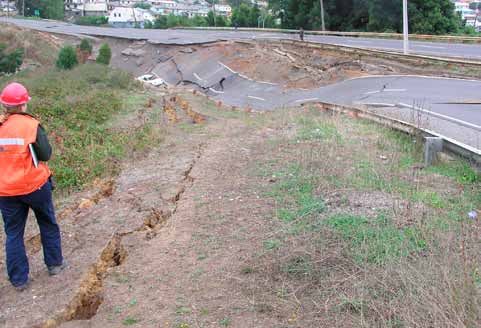
EERI Special Earthquake Report — June 2010

                                                                                       there was lateral spreading at the
                                                                                       east approach and several spans
                                                                                       collapsed in the middle. The Bio-Bio
                                                                                       Railroad Bridge, built in 1889 and
                                                                                       retrofitted in 2005, also suffered dam-
                                                                                       age associated with lateral spreading,
                                                                                       including lateral pile movement and
                                                                                       misalignment of the rails. Damage
                                                                                       from lateral spreading was also ob-
                                                                                       served at the La Mochita Bridge in
                                                                                       Concepción (significant transverse
                                                                                       movement), the Tubul Bridge in Tubul
                                                                                       (collapse), and the Pulen and Pata-
                                                                                       gual bridges near Hualqui (moderate
                                                                                       cracking and distortion). The Mata-
                                                                                       quito Bridge, built in 2008 near Iloca,
                                                                                       performed well, although lateral
                                                                                       spreading was observed at both
                                                                                       abutments, and up to 0.5 m of liq-
                                                                                       uefaction-induced settlement was
                                                                                       measured at one abutment.
                                                                                       Localized ground failures also had
  Figure 5. Schematic plan view of the Riesco building in Concepción (GEER,
                                                                                       widespread impact on highways
  2010).
                                                                                       throughout the region affected by
  ferential settlement across its foun-      Bridge, built in 1974, was closed due     the earthquake. Route 160 in Lota
  dation and 1 degree tilt in the north      to column shear failure induced by        along the coast was closed in both
  side of the building (Figure 5). As a      lateral spreading at the approach, as     directions due to embankment slope
  result of the uneven foundation set-       well as interior pier settlement in ex-   failures (Figure 7). Several ground
  tlement and rotation, excessive in-        cess of 0.5 m due to liquefaction.        failures were observed inland along
  ternal deformations were imposed           (See also Transportation Systems          the main north-south highway, Route
  on the coupling beams in the super-        below and Figure 26). At the Bio-Bio      5, often resulting in the closure of
  structure. Several homes in north-         Bridge, built in 1937 and closed in       either northbound or southbound
  ern Concepción were torn apart by          2002 to all but pedestrian traffic,       lanes (e.g., near Copihue, Parral,
  translational ground movement.
  Ports. Ports are essential facilities
  for the Chilean economy, as they
  carry more than 90% of the coun-
  try’s imports and exports. There
  was significant damage due to liq-
  uefaction and lateral spreading,
  notably at Valparaíso and Coronel.
  Figure 6 shows cracking of asphalt
  pavement at Coronel with lateral
  ground extension in excess of 1.2 m.
  Bridges and Roads. Liquefaction
  affected transportation systems
  most significantly along the coast.
  For example, all four bridges cross-
  ing the Bio-Bio River near Concep-
  ción were damaged to varying de-
  grees by liquefaction-induced
  ground failure. The Llacolen Bridge,
  built in 2000, suffered deck unseat-
  ing due to lateral spreading at its
                                              Figure 6. Liquefaction and lateral spreading-induced damage at the Port of
  north approach. The Juan Pablo II
                                              Coronel (photo: GEER, 2010).

                                                                4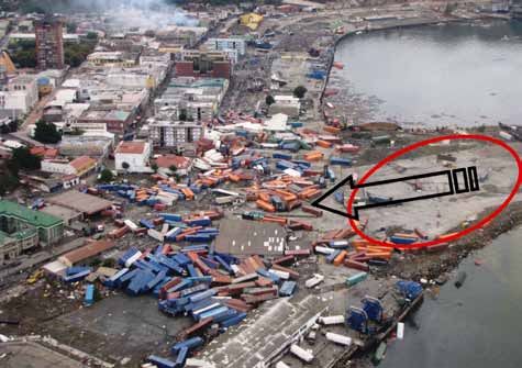
EERI Special Earthquake Report — June 2010

                                                                                    A conspicuous feature of the Chil-
                                                                                    ean tsunami was its extreme varia-
                                                                                    bility in height, destructiveness, and
                                                                                    wave arrival times (Table 2). Local
                                                                                    tsunami water height and arrival
                                                                                    times were influenced by bathym-
                                                                                    etry, coastal topography, aspect,
                                                                                    fault slip, and localized subsidence
                                                                                    and uplift due to the earthquake.
                                                                                    The first tsunami surges generally
                                                                                    arrived less than 30 minutes after
                                                                                    the earthquake; in most areas, eye
                                                                                    witnesses reported three or four
                                                                                    distinct surges. The third or the
                                                                                    fourth were typically the largest,
                                                                                    arriving between 90 minutes and
                                                                                    four hours after the earthquake.
                                                                                    The highest water levels recorded
                                                                                    by ITST groups were generally in
                                                                                    the 10–12 m range, excepting
Figure 7. Slope failure on Route 160 in Lota (photo: GEER 2010).                    splash values. Tidal variations of
                                                                                    about 1.6 m from rise to fall in
and Paine). These failures were                                                     20-30 minutes intervals were still
                                         The Tsunami                                observed in the Valparaíso area
often associated with lowland
crossings or under-highway culverts.     The earthquake produced a tsunami          7-8 hours after the earthquake,
                                         that caused major damage locally           revealing the intense excitation the
Earthen Structures. The perfor-          over 500 km of coastline, from Tirúa       Pacific Ocean experienced.
mance of earthen structures —            to Pichilemu, and at the Juan Fer-
dams, levees, mine tailings dams,                                                   Tsunami damage to structures re-
                                         nandez Islands about 600 km off the
and retaining structures — was good                                                 sulted from hydrodynamic loading
                                         coast. Around the Pacific, the tsunami
overall. The earthquake struck near                                                 on structural elements, impact load-
                                         was recorded at over 150 locations,
the end of the dry season in Chile,                                                 ing from floating debris, and scour
                                         triggering tsunami alerts (Warnings/
when reservoir levels are low. A                                                    around foundations, especially dur-
                                         Advisories) in 54 countries and ter-
small number of earth structures did                                                ing drawdown. Timber-framed
                                         ritories. Post-event field investigation
exhibit adverse effects. For example,                                               homes and unreinforced or poorly
                                         International Tsunami Survey Teams
Coihueco Dam, which is a 31-m-                                                      reinforced masonry structures were
                                         (ITST) were coordinated by UNESCO
high zoned earth fill dam, had sev-                                                 particularly vulnerable (Figure 9).
                                         and the International Tsunami Infor-
eral scarps along its upstream crest,                                               In Dichato, 1500 homes were
                                         mation Center (ITIC, 2010).
as well as bulging along the up-
stream toe. The most significant fail-
ure of an earth structure was at the
Las Palmas Tailings Impoundment,
where liquefaction resulted in a flow
failure of as much as 100,000 m3
of retained tailings a distance of up
to 0.5 km and caused four casual-
ties (Figure 8). Another interesting
failure was in a 7-m-high earth levee
constructed with a silty-sandy gravel
with cobbles near Colbún. While this
section of levee showed no signs of
distress after both the February 27
event and a Mw 6.9 aftershock on
March 11, it subsequently failed on
March 13.

                                         Figure 8. Upper scarp of Failed Tailings Impoundment (photo: GEER 2010).

                                                            5
EERI Special Earthquake Report — June 2010

                 Table 2. Water Heights and Wave Arrival Times                             casualties and missing were attrib-
                             Water Height      Approximate Wave Arrival Time
                                                                                  2        uted to the tsunami (Forensic Medi-
         Community              meters
                                           1
                                                1
                                                    st
                                                         2nd    3rd        4th             cal Service, 2010). With the notable
         Curanipe                 6-9                                  6:30 - 7:00         exception of Constitución (see
         Constituci—n        6.9 - 11.2, 26*   3:50      4:17   4:50       5:20
                                                                                           below), few coastal residents died
         Dichato                3.6 - 9.4      4:00      5:00              7:30
                                                                                           in the tsunami, because of a high
                                                                                           level of tsunami awareness. Older
         Iloca                   4 - 8.2       4:00      4:25
                                                                                           residents had personal experience
         Juan Fernandez            5           4:25      4:40
                                                                                           of the 1960 earthquake and tsunami,
         Pellehue               7.2 - 9.3      4:15                        7:30
                                                                                           and many coastal residents recog-
         Pichilemu                 4           3:50      4:20
                                                                                           nized ground shaking as the warn-
         San Antonio            2.5 - 3.4      3:50      4:20
                                                                                           ing. Many towns had posted tsunami
         Talcahuano             3.3 - 6.3      3:54      5:30   6:00       6:40
                                                                                           hazard zone signs and/or tsunami
          Valpara’so                2.6          4:00    4:50  5:20       6:00
        1                                                                                  evacuation zone signs (Figure 12).
          Compilation of preliminary water heights from NGDC (2010), ITST and EERI teams
        2
          Based on eyewitness accounts from ITST teams and El Mercurio (2010)              In Chile, all schools are required to
        * Splash estimate                                                                  prepare for local natural hazards,
                                                                                           and the coastal schools had robust
 destroyed, primarily because of               no were also damaged due to up-             tsunami awareness and education
 hydrodynamic loads, though debris             lifted large naval ships and barges.        programs.
 generated by failed homes may
                                               Scouring of shallow foundations             Most vulnerable were unaware tran-
 have progressively contributed to
                                               caused a number of buildings to col-        sient populations. The single largest
 the loading. Light-framed buildings
                                               lapse (Figure 11). Sheetpile wharfs in      loss of life from either ground shak-
 were destroyed in many other coast-
                                               Talcahuano Harbor collapsed or were         ing or inundation was in Constitu-
 al towns. Reinforced concrete build-
                                               damaged by soil failure induced by          ción, where numerous people died
 ings, on the other hand, performed
                                               tsunami inundation and drawdown.            on La Isla Orrego in the River Maule
 very well structurally, even when
                                               Elevated pore pressures led to fluid-       (LA Times, 2010). The island was
 inundation reached well above the
                                               ization of backfill during tsunami inun-    accessible only by boat, had no high
 second floor level.
                                               dation and drawdown, causing severe         ground, and was an informal camp-
 Bridges on coastal highways also              scour that damaged sheetpile wharf          ground packed on the weekend of
 sustained tsunami damage such as              structures, machinery with shallow          February 27. In other areas, camp-
 the lateral distortion of the super-          foundations, and soil-supported pave-       grounds were also filled. Campers in
 structure of the Pichibudi Bridge             ments. Eyewitness reports from dock-        Pellehue and Curanipe accounted
 just north of Iloca, the undermining          workers indicated that the majority of      for large numbers of fatalities. There
 of several piers due to scour and             damage was caused by the tsunami.           were no education programs target-
 the puncture of steel pile bents by           According to Ministry of Interior data      ing tourists or other transient popula-
 floating debris in the Cardenal Silva         in May 2010, 124 of the 521 identified      tions.
 Henriquez Bridge across the Maule
 River at Constitución.
 In Talcahuano, nonstructural dam-
 age was widespread; almost all
 exterior enclosures and contents of
 commercial buildings and industrial
 warehouses along the shorefront
 were damaged by the hydrodynamic
 loading of the flooding and debris
 field, and the commercial fishing
 facilities along the wharf were also
 rendered inoperable. Debris impact,
 particularly in the form of fishing
 vessels, shipping containers, and
 trucks, caused damage to masonry
 and steel-framed harbor buildings,
 though reinforced concrete struc-
 tures were generally able to with-
                                                Figure 9. Wood building on left in Dichato was transported from across street
 stand the battering (Figure 10). The
                                                and collided with the concrete frame building on the right. Arrow shows water
 piers at the Naval Base at Talcahua-
                                                height (photo: L. Dengler).

                                                                       6
EERI Special Earthquake Report — June 2010

                                                                                    Fortunately a 12-year-old girl who
                                                                                    felt the earthquake rang a village
                                                                                    bell, alerting most of the residents
                                                                                    on Robinson Crusoe Island (The
                                                                                    Independent, 2010).

                                                                                    Buildings
                                                                                    Earthquake shaking caused exten-
                                                                                    sive damage to many non-engi-
                                                                                    neered and engineered buildings
                                                                                    throughout the affected area. The
                                                                                    team focused on concrete, masonry,
                                                                                    and adobe construction, as this
                                                                                    constitutes the vast majority of
                                                                                    buildings. Some damage to steel
                                                                                    buildings also was observed, but is
                                                                                    not reported here.
                                                                                    The region contains a large number
                                                                                    of older houses, churches, and
Figure 10. Talcahuano Harbor 3 days after the tsunami (photo: Intl. Federation      other buildings constructed of adobe
of Red Cross Red Crescent Societies). Shipping containers were originally           or unreinforced masonry. Seismic
stacked in the area of the red ellipse and displaced up to 300 m in the direction   resistance typically is provided by
of the arrow.                                                                       walls located around the perimeter
                                                                                    and, to a lesser extent, at the inter-
There were difficulties with Chile’s     tween the earthquake and tsunami,          ior. Absence of reinforcement and
tsunami warning system. An initial       the failure of the official warning        weak connections between adjoin-
warning was cancelled by the Navy’s      system may have had little impact,         ing walls apparently led to the col-
Hydrographic and Oceanographic           although there are some reported           lapse of walls and roofs in many
Services and announced on the ra-        cases of people returning to the coast     buildings, contributing to some hu-
dio by Chile’s president. In Chilean     after hearing of the cancellation. In      man fatalities. In addition, delam-
coastal communities, where most          the Juan Fernandez Islands, 600 km         ination of exterior stucco, while not
people recognized natural warning        off the coast, the lack of timely warn-    jeopardizing the structural sys-
signs and there was little time be-      ings may have hindered evacuations.        tem, created the appearance of
                                                                                    significant damage in many other
                                                                                    buildings. Damage was especially
                                                                                    severe between latitudes 34.5° and
                                                                                    36.5°, a length of 240 km (Astroza
                                                                                    et al., 2010). Figure 13 shows a typ-
                                                                                    ical street scene from Talca. Historic
                                                                                    churches were particularly hard hit,
                                                                                    with extensive damage observed
                                                                                    from Santiago to Concepción.
                                                                                    Confined masonry construction is
                                                                                    also widely used for buildings one to
                                                                                    four stories tall (Figure 14). Exterior
                                                                                    walls of clay bricks are first con-
                                                                                    structed on a concrete foundation
                                                                                    and then reinforced concrete confin-
                                                                                    ing elements are cast around the
                                                                                    brick walls, forming a tight bond be-
                                                                                    tween the masonry and concrete
                                                                                    elements. These buildings generally
                                                                                    performed very well; typical damage
Figure 11. This concrete frame and confined masonry building in Dichato
                                                                                    (where observed) included diago-
survived the hydrodynamic loads, but suffered substantial foundation scour
                                                                                    nal cracking of masonry walls and
(photo: G. Chock).

                                                             7
EERI Special Earthquake Report — June 2010
walls framing from the corridor to ity of damage was concentrated in
the building exterior. Typical ratios newer buildings.
of wall to floor areas are relatively
Figure 15 shows typical damage to
high compared with concrete build-
a transverse wall in the first story of
ing construction in the U.S. In 1996,
a ten-story building in Viña del Mar.
Chile adopted a seismic code with
Note the setback in the wall profile
analysis procedures similar to those
at this level, provided mainly to ac-
in UBC-97, but there are no prohibi-
commodate automobile access to
tions or penalties related to vertical
parking spaces. This condition was
or horizontal system irregularities.
observed in several buildings; in
NCh433-1996 also enforces provi-
buildings with subterranean parking,
sions of ACI 318-95; however, in
this damage was likely in the first
light of good building performance
level below grade.
in the March 1985 earthquake, it
was not required to provide closely Figure 16 shows a failed wall from
spaced transverse reinforcement a subterranean level of a 12-story
around wall vertical boundary bars. building in which large steel pipe col-
Starting in 2008, the new Chilean umns were being used to raise the
Reinforced Concrete Code does re- building to enable repairs. Given the
quire use of boundary elements. An wide spacing of transverse rein-
Figure 12. Tsunami evacuation
apparent trend is to use thinner walls forcement, there was little bearing
sign, Curanipe (photo: N. Graehl).
in recent years than in the past. section remaining in the thin wall
wall failure due to lack of confining and the entire wall section buckled
The team observed severe damage
elements around openings or poor laterally. In this example the longi-
to 31 concrete wall buildings (10-26
quality of the confinements. tudinal bars buckled without frac-
stories) in or around Santiago, Viña
ture; in many other examples the
The vast majority of mid- to high- del Mar, Chillán, and Concepción.
longitudinal bars were fractured. It
rise buildings in Chile are construct- In Viña del Mar, damage was gener-
was reported that, even though not
ed of reinforced concrete. Most of ally concentrated in the alluvial plain
required by the local building code,
these rely on structural walls to re- directly north of the Marga-Marga
some engineers used transverse
sist both gravity and earthquake River, where a majority of the taller
reinforcement conforming to the ACI
loads; some more recent construc- buildings are located. Some build-
Building Code. The team did not
tion uses a dual system of walls ings damaged in the 1985 earth-
observe that type of reinforcement in
and frames. A typical high-rise plan quake (and repaired) were again
any damaged buildings.
has corridor walls centered on the seriously damaged (e.g., Festival
longitudinal axis, with transverse and Acapulco); however, a major- Coupling beams over doorways
along corridor walls are typically
reinforced with small-diameter
hoops at relatively large spacing
(20 cm); many buildings had dam-
age to these beams. Some build-
ings omitted the coupling beams; in
many cases, damage resulted from
the slab acting as a coupling ele-
ment. There were several examples
of doors becoming jammed be-
cause of permanent offsets in the
walls adjacent to the opening. The
team also observed spalled cover
over lap splices of wall boundary
reinforcement.
Several of the severely damaged
mid- to high-rise buildings had
permanent offsets at the roof, appar-
ently due to subsidence of walls,
raising questions about repairability.
Figure 13. Street in Talca (photo: J. Moehle). Four concrete buildings collapsed
8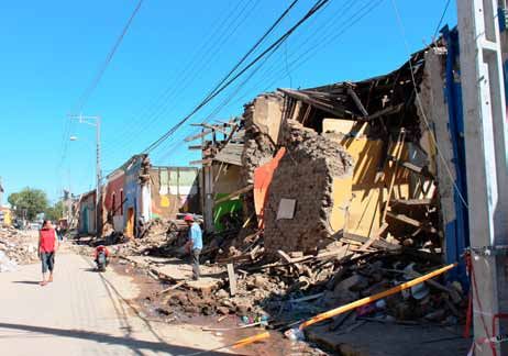
EERI Special Earthquake Report — June 2010

                                                             The recently com-     and cable trays (Figure 19). The
                                                             pleted 23-story       widespread nonstructural damage
                                                             O’Higgins 241         caused significant economic loss
                                                             office tower in       and major disruption to the normal
                                                             Concepción suf-       functioning of Chilean society.
                                                             fered partial story   With few exceptions (e.g., some new-
                                                             collapses at levels   er hospitals), Chilean practice on
                                                             10, 14, and 18,       seismic anchoring/bracing of non-
                                                             each coincident       structural components lags consid-
                                                             with a framing set-   erably behind earthquake-resistant
                                                             back (Figure 18).     design practice for structural sys-
                                                             The perforated        tems. Although Section 8 of the Chil-
                                                             shear walls on the    ean seismic code (NCh 433.Of96)
                                                             east face (shown)     includes provisions for nonstructural
                                                             and south face        components, these are usually not
                                                             showed damage to      enforced unless requested by build-
                                                             both wall piers and   ing owners, as in newer hospital
                                                             spandrels. Exterior   construction. The state of practice is
                                                             north and west        similar to that for buildings construct-
                                                             faces appeared        ed in the early 1970s in California or
                                                             undamaged.            typical current practice in other U.S.
                                                                                   regions of moderate seismicity. As
                                                             Nonstructural         with U.S. practice, for most buildings
                                                             Components            it is not clear who is responsible for
Figure 14. Engineered confined masonry apartment             and Systems           the design, installation, and inspec-
building, showing confining elements at boundaries of                              tion of seismic anchoring and bracing
                                                             There was exten-
walls and openings (photo: M. Astroza).                                            of nonstructural components.
                                                             sive nonstructural
                                        damage in practically all types of         Nonstructural damage resulted in the
completely or partially. Two of         buildings — residential, commercial,       closure of the international airports in
these were nearly identical, proxi-     and industrial. Commonly observed          Santiago (see Figure 20) and Con-
mate, five-story buildings in Maipú,    was damage to glazing, ceilings, fire      cepción, which together handle more
Santiago. These buildings had four      sprinkler systems, piping systems, el-     than two thirds of the air traffic in
stories of condominium units atop a     evators, partitions, air handling units,   Chile. The cost of the earthquake to
first-story parking level with a highly
irregular wall layout. Wall failure
likely contributed to the collapses.
A third collapsed building was the
15-story Alto Río condominium in
Concepción (Figure 17). The team
was unable to examine closely the
side of the building toward which it
collapsed, but the structural draw-
ings indicate that concrete walls on
the façade were discontinued, and
the wall length was decreased in
the first story on the side toward
which the building collapsed. The
building apparently rotated about
its corridor walls as it collapsed,
leading to tension failures of the
transverse walls on the other side
(the side from which the photo was
taken). Some of the wall vertical
reinforcement fractured and some
lap splices failed on the tension
side.                                    Figure 15. Wall damage, Viña del Mar (photo: P. Bonelli).

                                                            9
EERI Special Earthquake Report — June 2010

                                                                                         for 71% of all public hospitals in
                                                                                         Chile. The Chilean Ministry of
                                                                                         Health (MINSAL) found that of
                                                                                         these, four hospitals became
                                                                                         uninhabitable, twelve had greater
                                                                                         than 75% loss of function, eight
                                                                                         were operating only partially after
                                                                                         the main shock, and 62% needed
                                                                                         repairs or replacement. Of the
                                                                                         beds in public hospitals, 18%
                                                                                         continued to be out of service
                                                                                         one month after the earthquake.
                                                                                         MINSAL estimates the damage at
                                                                                         $2.8B, and expects the replace-
                                                                                         ment of severely damaged hospi-
                                                                                         tals to take three to four years.
                                                                                         The hospital operability study was
                                                                                         focused on the Bio-Bio province of
                                                                                         Chile. The only hospital in the cho-
                                                                                         sen study area with structural dam-
                                                                                         age is the Victor Rios Ruiz Hospi-
  Figure 16. Wall damage, Santiago. Note the 90-degree bends on the trans-               tal of Los Angeles. In one of the
  verse reinforcement (photo: J. Wallace).                                               newer buildings of this hospital,
                                                                                         braced by concrete frames with
 LAN Airlines, the national airline in       substantial economic losses. This is        shear walls, the penthouse was
 Chile, was approximately $25 million        especially important for critical facili-   severely racked due to torsion,
 in lost passenger traffic alone.            ties such as hospitals, airports, and       and steel roof trusses buckled.
                                             water distribution systems.                 Two other buildings, circa 2005,
 Of the 130 public hospitals in re-
                                                                                         had damage to some columns,
 gions affected by the earthquake,
                                             Hospitals and Health Care                   slight cracking on the shear walls,
 62% suffered nonstructural dam-
                                                                                         and collapsed in-fill walls. This wall
 age requiring repairs. Most of the          The 130 hospitals in the six regions
                                                                                         failure caused damage to nearby
 economic loss, closures, and evac-          affected by the earthquake account
 uations in hospitals are attributed to
 nonstructural damage. For example,
 of the hospitals that were partially or
 completely closed as a result of the
 earthquake, 83% lost some or all
 functionality exclusively due to non-
 structural damage (they suffered no
 structural damage).
 Santiago’s 131 emergency call cen-
 ter (analogous to 911 in the U.S.),
 located in the uppermost level of
 the Posta Central building, suffered
 severe nonstructural damage and
 could not operate following the
 earthquake. Nonstructural damage
 also caused significant losses and
 disruption to industries associated
 with paper, wine, grain, and fruit.
 This earthquake illustrates the im-
 portance of improving seismic per-
 formance of nonstructural compo-
 nents, the failure of which can lead
 to injuries, loss of functionality, and     Figure 17. Collapsed Alto Río tower showing underside (photo: J. Maffei).

                                                                 10
EERI Special Earthquake Report — June 2010
cracking of the plaster Lifelines
over brick walls, and
partition damage. The The TCLEE reconnaissance team
collapse of ceilings and examined earthquake impacts to
associated light fixtures electric power, telecommunication,
and mechanical grills water and wastewater, gas and
(Figure 21a) discomfited liquid fuel, and other lifelines (not
occupants and caused presented here), and evaluated
unsanitary conditions lifeline interdependence and resil-
that led to many evacu- ience. The study of lifeline resilien-
ations. cy must continue with a focus on
cost-effective preparedness and
A few hospitals also had loss reduction for lifeline service
moderate water dam- providers.
age from pipe failures.
Most buildings that re- Electric Power. The transmission
quired evacuation also network performed reasonably well
lost use of elevators — and was ready to provide power
due to lack of power or 24 hours after the main shock. The
failure of the counter- long, narrow configuration of the
weight rails — forcing system — dictated by the shape of
staff to carry patients the country and the topography of
down rubble-strewn the land — limits transmission line
stairs. However, the route dispersion and system redun-
only reported patient dancy. While much of the equip-
casualties were due to ment is the same as that found in
heart attacks. the United States, Chile makes
extensive use of pantograph dis-
Although no hospital lost connect switches and candlestick
the capacity to
Figure 18. O’Higgins 241 office tower (photo: E. provide all regular
Miranda). service, all but
one saw reduc-
distilled water tanks, subsequently tions in multiple services for
shutting down half of the hospital up to seven days. Radiologic
surgical ward, located on the floor and laboratory services were
below, due to water damage. The most affected by earthquake
saw no evidence of structural dam- damage. In terms of patient
age in any of the one-story hospi- care, the largest deficit was due
tals of the Bio-Bio province built to the loss of 54% of beds in
after the 1960 earthquake. the Los Angeles Hospital. With
hospital non-clinical services,
Although structural damage was the most frequent interruption
minimal in hospitals, most suffered was due to the loss of patient
nonstructural damage, and frequent- medical records (Figure 21b) in
ly, loss of utilities. All hospitals in the collapsed and tipped file man-
study area lost municipal electrical agement systems.
power and communication for sev-
eral days, and 71% lost their munici- The team visited three seis-
pal water supplies. All hospitals were mically isolated hospital build-
equipped with backup power and ings in Santiago; none was
water supplies, but such redundancy damaged other than at joints
was not present in their communica- with adjacent buildings or
tion system, creating enormous diffi- other structures. In two cases,
culties for aid coordination. immediately adjacent fixed-
base buildings had moderate Figure 19. Nonstructural damage in the
Additionally, most hospitals reported nonstructural damage. Talca Supreme Court building constructed
damage to their suspended ceilings,
in 2003 (photo: E. Miranda).
11EERI Special Earthquake Report — June 2010
live-tank circuit breakers, which
are used sparingly in the western
United States. There were more
than 25 failures reported in these
elements, but that represented only
a small percentage of the inventory
(Figure 22). The backbone 220 kV
and 500 kV systems, which were
designed with earthquake provi-
sions, performed reasonably well
overall. Lower voltage subtransmis-
sion systems near the coast, where
there were higher levels of ground
shaking, were damaged sporadi-
cally. The low-voltage distribution
system was also affected by col-
lapsed buildings and damaged
poles. Two weeks after the earth-
quake, the distribution system ser- Figure 20. Nonstructural damage at the Santiago International Airport ter-
vice was restored. minal (photo: E. Miranda).
Telecommunication. Both landline difficult; additionally, many utilities damage to the various Essbio
and wireless services were bedev- that relied on wireless service found water systems was concentrated
iled by commercial power outages, it difficult to dispatch maintenance in Concepción and Talcahauno.
equipment failures, building fail- crews in order to restore service. Areas within 60 m (or so) of river
ures, and loss of reserve power in Both landline and wireless services banks often were affected by lateral
most distributed network facilities were restored within seven days spreading and settlement, and
(base stations, small remote switch- of the quake. tsunami-related destruction to build-
es, and digital loop carrier [DLC] re- ings and sea walls damaged buried
mote terminals). Only critical offices Water and Wastewater. Chilean water
water pipes. At the Concepción-
have backup power generators, utility Essbio delivers potable water to
area water treatment plant, there
with the majority of cell sites and urban areas, serving about 4 million
was severe damage to the raw
remote offices relying on battery people. The potable water systems
water intake structure from both lat-
reserve power; by about 6:30 a.m., include about 7,000 km of transmis-
eral spreading and ground shaking;
most cell sites and remote sites ran sion and distribution pipe, of which
internal damage to the four clarifiers
out of power. Damage to roads and 1,200 km are in the city of Concep-
(baffles, settlers and supporting
bridges made access to these sites ción. By far the largest amount of
elements); damage to suspended
Figure 21. (a) Ceiling collapse and nonstructural damage in Chilean hospital (photo: W. Holmes), and (b) tedious
reorganization of medical records three weeks after the earthquake (photo: J. Mitrani-Reiser).
12EERI Special Earthquake Report — June 2010
ceilings (control room, water quality
laboratory); toppling of control room
computer monitors and computers;
and toppling of water quality equip-
ment and glassware from counter-
tops. In the Concepción-area
distribution system, there were 72
breaks or leaks to large diameter
(500+ mm) welded steel pipes; as
of April 12, 2010, about 3,000 re-
pairs had been made to smaller
diameter pipes, of which about 2/3
were for service laterals and 1/3 for
pipe mains.
Over the past 50 years, the federal
government of Chile has construct-
ed nearly 2,000 small rural potable
water systems country-wide, of
which about 420 were in the areas
of strong shaking. At least 73 of the
elevated tanks completely collapsed Figure 22. Damaged candlestick style live-tank circuit breakers (photo:
(Figure 23). TCLEE).
There was heavy damage to waste- ción. Both refineries shut down (loss is currently being imported. It has
water systems, including treatment of power, need to appraise possible been estimated that three to seven
plants, large-diameter interceptor damage) with only minor, non-critical months will be required to bring the
pipes, and small-diameter collector damage. The Aconcagua refinery refinery to its operating capacity of
pipes. Due to the damage, there near Santiago had minor damage and 130,000 barrels per day.
were direct discharges of sewage restarted ten days after the earth-
into rivers. Primary causes of dam- quake. At the Bio-Bio refinery near Lifeline Interdependence and Re-
age were permanent ground defor- Concepción, the refractory in the heat- silience. Infrastructure interdepen-
mations for pipes and inertial over- ers fell to the heater floors, and one of dence among power, transportation,
loads to structures. the two steel crude oil pipelines feed- telecommunication and water sys-
ing into the refinery failed due to liq- tems increased their loss of func-
Gas and Liquid Fuel. Chile has uefaction and lateral spreading of tionality or delayed the restoration
two principal oil refineries, one west beach sands. The gasoline and diesel processes. This additional loss of
of Santiago and one in Concep- for the service area of this refinery functionality reduced regional re-
silience, and it was triggered by
physical and cyber interaction among
lifeline systems, as well as by co-
location, and by relational and logist-
ical coupling among infrastructures
and institutional entities.
The early post-earthquake phase
was characterized by uncertainty
about road conditions and the ab-
sence of power. Blackouts impaired
telecommunication system opera-
tion. Uncertainty about refinery shut-
downs and fuel availability hampered
water systems’ operation of the un-
damaged and repaired portions of
the network. Lack of telecommunica-
tions during the blackout phase also
led to delays in assessing the
Figure 23. Typical collapsed elevated small steel tank (constructed in 1999) damage and safety of the power
(photo: TCLEE).
13EERI Special Earthquake Report — June 2010
distribution system. This phase ports, and airports as noted above. Vertical rods and hold-down ties
had different durations in different Highways and railroads between were provided to prevent uplift,
regions, but for the Concepción Concepción and Constitución also after high vertical ground accel-
area, it lasted about three days. had substantial tsunami damage. erations were recorded during the
The subsequent phase was charac- The most serious damage occurred 1985 earthquake. These rods and
terized by the increasing availability to roads and bridges. Of the nearly ties were largely ineffective in the
of alternate transportation routes, 12,000 highway bridges in Chile, transverse direction, and many
restoration of power at the sub- approximately 200 were damaged. spans slid sideways on their cap
transmission levels, a steady recov- About 20 of these bridges had col- beams. This lack of restraint also
ery of telecommunications, water lapsed spans. Before the mid-1980s, allowed a number of two-span
and gas, and improving power deliv- the bridge design code in Chile bridges to rotate about a vertical
ery to customers along main feeders was based on the provisions in the axis through the pier and slide off
and then laterals. AASHTO Standard Specifications of their abutments seats (Figure 24).
that time, with a seismic design coef- In addition, several skewed spans
Although important underground,
ficient of 0.12. This coefficient was with diaphragms and shear keys
overhead, and surface level co-
increased to 0.15 following the 1985 also rotated about a vertical axis
located infrastructure was observed
earthquake, and a modified version of and were unseated in their acute
in the field, in only a few instances
Division I-A of the AASHTO Standard corners, due to insufficient support
were there interdependence-
Specifications was adopted in 1998. length (Figure 25). Straight bridges
induced failures. These included
The design coefficient was not, how- built before the concession era and
telecommunication, gas, and water
ever, changed until 2001, when three those with cast-in-place diaphragms
lines conveyed by collapsed or
seismic zones were introduced with and concrete shear keys behaved
excessively displaced bridges at
PGAs of 0.2, 0.3, and 0.4g. Columns well.
waterway crossings, electric train
were required to be designed to the
halts from power and telecommuni- Despite higher-than-anticipated
requirements for Performance Cat-
cation downed poles, rooftop tele- spectral accelerations, column dam-
egories C and D of Division I-A.
communication structure failures or age was slight, perhaps because
interrupted operations at collapsed Since the mid-1990s, a number of ma- the lack of transverse restraint and
buildings, and power distribution jor highways have been constructed insufficient support length allowed
overhead lines pulled down by col- in Chile using design-build-and-oper- many superstructures to separate
lapsed facades or structures. ate contracts with entities known as from their substructures, limiting
concessions. Many of the bridges the demand on the columns. Where
Most lifeline companies managed
built by these concessions used pre- this did not happen, column dam-
to avoid operational personnel
cast, prestressed concrete girder su- age was more likely to occur, such
shortages by supporting workers
perstructures without diaphragms or as the shear failures of several col-
with food and water provisions, and
shear keys for transverse restraint. umns under the approach span to
by linking to relative search pro-
grams. However, the services of
some companies, such as banks in
dense urban areas, are not going to
receive power and other utility
services until demolition of tagged
buildings takes place, despite hav-
ing completed their own retrofit
projects. Re-installation of utility
infrastructure can interrupt their
business for another three or four
months. Further, the rate of lifeline
restoration slowed down after a
majority of customers were back on
line, so the remaining residential
and commercial users endured sig-
nificant inconvenience and indirect
losses.
Figure 24. Lateral movement of the superstructure of Las Mercedes Bridge
Transportation Systems across Route 5 near Rancagua, due to absence of end diaphragms and
Ground shaking and liquefaction transverse shear keys. Note extreme deformation of vertical seismic bars and
damaged highways, railroads, damaged curtain walls (photo: Ministerio de Obras Públicas).
14EERI Special Earthquake Report — June 2010
the Juan Pablo II Bridge across the designed to the recent NCh2369 seis- buckling of steel braces near the
Bio-Bio River in Concepción, appar- mic design code for industrial facilities top of its main bagging facility, and
ently due to imposed displacements performed well structurally; however, damage due to excessive move-
from liquefaction-induced lateral significant downtime and losses ment of equipment. The Bio-Bio
spreading (Figure 26). Other resulted from improperly anchored plant at Talcahuano apparently suf-
bridges across the Bio-Bio River equipment and contents. fered more damage, but the team
also suffered damage from lateral was unable to visit that installation.
Wineries. Some older wineries with
spreading, as noted above under
adobe walls and timber roofs or Cellulose Plants. The large Arauco
Geotechnical Effects.
ribbed brick vaults sustained localized brown paper plant in Constitución
The Ferrocarril del Pacífico S.A. collapses. Modern warehouse struc- had minimal structural damage from
(FEPASA) maintains tracks paral- tures were minimally damaged, most- ground shaking, but much of the
lel to the Pan-American Highway ly in the tension braces, but there was equipment was submerged and dis-
(Route 5), and several areas of damage to steel fermentation tanks, placed from its original location by
track and railway bridges were barrel stacks, and bottle storage the tsunami. Water damage to the
damaged due to soil movement. racks. One wine industry representa- equipment controls systems was
Several piers and bearings sup- tive reported that more than 75% of serious. Another Arauco cellulose
porting the rail bridge at Chepe Hill total capital loss was from loss of wine plant at Nueva Aldea, near Chillán,
across the Bio-Bio River in Con- from stainless steel tanks, with most appeared to have suffered no seri-
cepción were damaged by lateral of the remainder from damage to the ous damage.
spreading. Tsunami damage was tanks themselves. Local buckling of
Power Plants. The team visited the
reported between Constitución and legged tanks in many cases led to
350 MW Santa Maria power plant
Talca; however, repairs were made subsidence or toppling that ruptured
under construction in Coronel, south
quickly, and the railroads were used piping or valves, leading to loss of
of Concepción. The plant is about
to help remove earthquake debris. wine (Figure 28). Total wine losses
60% complete and consists primar-
were estimated at over 125M liters.
Damage to the major ports of Val- ily of three very large braced steel
paraíso and Concepción (Coronel) Cement Factories. The very large, frames. Damage was limited to por-
has been attributed to strong shak- modern Bio-Bio cement plant south tions of the structure that had not
ing and liquefaction-induced lateral of Curico (about 100km from the epi- been finished or where there was
spreading, rather than the tsunami. center) suffered only minor damage seismic settlement under some foun-
The San Antonio Port had been to its installations, mostly in the form dations that were on spread footings.
reconstructed between 1992 and of fine shear cracks around some of
Refineries and Steel Mills. The
1997, and was undamaged. A new, its larger concrete silos, some minor
team was unable to enter either the
seismically isolated wharf in Coronel
(Figure 27), carrying two container
cranes, was not damaged, whereas
a neighboring conventional wharf
of similar size had weld failures in
some steel pile bents.
Industrial Facilities
The Chilean economy is heavily
centered on minerals extraction,
agricultural production, and forestry.
The agricultural and wine produc-
tion regions, stretching south from
Santiago towards Valdivia, were
affected by the earthquake, as
were the paper and cellulose mills
located in the areas from Consti-
tución south. Steel mills, refineries,
and cement and electricity plants
in the Concepción area were also
damaged, some seriously. The Figure 25. Unseating at the abutment of the skewed steel plate girder, Matta-
overall impression from the team Quilicura Bridge, north of Santiago, due to insufficient support length (photo: J.
is that modern industrial facilities Arias).
15EERI Special Earthquake Report — June 2010
contents fell to the floor in Governance and Territorial Order.
the extended shaking. A There are four tiers of territorial
number of spectacular col- planning: national, regional (involv-
lapses of stacked, unse- ing one or more provinces), inter-
cured storage drums and municipal, and municipal. Nation-
similar items were evident ally, the Ministry of Housing and
in food processing facilities. Urban Development is in charge
of regulations and ordinances for
Social Impacts, urban development and land use,
Response, and building construction, and commu-
Recovery nity facilities. The Ministry of the
Interior is in charge of regional
In the 1960 Valdivia earth- plans (http://www.subdere.gov.cl).
quake, 428 Chileans per Regional planning is legally dele-
million lost their lives; by gated to administrative regions by
comparison, only 31 Chil- way of territorial regulatory plans
eans per million lost their and intermunicipal plans, while
lives in the 2010 quake. municipal plans and district plans
This can be attributed to fall under the authority of municipal
effective governance as governments. Neighborhood orga-
measured by economic nizations provide local linkages to
prosperity, physical infra- municipal and district planning. The
structure standards, con- Ministry of Planning (www.
struction code enforcement, Mideplan.cl) works on the social
and state-society institution- well-being aspects of development.
Figure 26. Shear failure in a column in northern al assets. Table 3 presents
approach to Juan Pablo II Bridge across Bio-Bio a damage assessment Risk reduction and emergency mea-
River, Concepción, due to lateral spreading and overview. Chile offers im- sures are articulated, if inconsistent-
the propping action of the superstructure at the portant lessons in disaster ly so, at the various tiers of territorial
top of the column (photo: J. Arias). policy and highlights the planning. Since 2002, the Program
interplay between pre- and of Updating Territorial Planning Reg-
post-disaster social and spatial in- ulations has modernized Chile’s
large ENAP refinery or the CAP steel
equalities. There is an excellent oppor- instruments of urban and regional
mill in the San Vicente/Talcahuano
tunity for long-term policy-relevant planning, though it does not yet
area. Both facilities were out of pro-
research on the rebuilding of families, mandate risk assessment at each
duction and appeared to have suf-
housing, neighborhoods, communities, level of regional and local planning.
fered significant structural damage.
livelihoods, and economies. Natural hazard risks are to be ad-
Food Processing Facilities and
Warehouses. The team entered
only a limited number of these
structures, but it appeared that most
light industrial steel buildings per-
formed well, even if the anchorages
at the column bases would have
been considered insufficient by to-
day’s standards. Similar precast
concrete structures did not fare so
well, as there was evidence of con-
nection distress in the wall panel
connections and some panel col-
lapses. Numerous examples of silo
failures were observed; perfor-
mance depended on support details
and whether silos were full. Storage
racks seem to have performed well
even if the anchorage to the floors
was minimal; however, most of their
Figure 27. Base-isolated wharf at Coronel (photo: E. Miranda).
16EERI Special Earthquake Report — June 2010
ment and alert between ONEMI and
ministries such as Defense, Interior,
Housing and Urban Development,
Health, and Education, Public
Works, and the Hydrolographic and
Oceanographic Institute. Clearly,
the communication system requires
upgrading, as the disaster interrupt-
ed cell phone service, and few
satellite phones are available.
The need to strengthen local cap-
acities refers not just to govern-
ments, but also to synergies with
non-governmental organizations.
Universities responded quickly to
the disaster by supplying volunteers
Figure 28. Typical damage to storage tanks in wineries (photo: R. Leon). and other levels of support. The
Red Cross (with centers in Santi-
dressed in detail in a city-level gen- Although municipal emergency com- ago, Talca, and Concepción) and
eral plan, but disaster management mittees carried out search and rescue the Catholic Church, operating
often suffers from tensions between and damage assessment profession- through CARITAS, have been lead-
territorial planning guidelines and ally, given the resources available, the ers in providing medical, material,
private land development interests, central government’s slow emergency social, and psychological assis-
especially in coastal zones. A Na- response led to some looting and tance. The Catholic Church’s hous-
tional Coastal Commission contrib- breakdown in civic order. The plight of ing NGO, “Un Techo para Chile,”
utes to the formulation of coastal the poor living in overcrowded condi- has built small housing settlements
land use policy; however, its recom- tions was brought to public awareness (30-40 units on a site) in many
mendations are not binding. The and everyone could see the two faces affected cities.
Ministry of the Interior’s SUBDERE of the country: the modern versus the Insurance. Insured losses from the
(Subsecretaria para Desarrollo Re- marginalized. earthquake are estimated in the
gional y Administrativo) serves as $US 6-9 billion range. By law, the
The new president, Sabastian Piñera,
an intermediary between central water and electricity utility compa-
is beginning the task of improving the
government and regional-local gov- nies (which are privatized) are re-
coordination of emergency manage-
ernment.
Disaster Response. In general, the Table 3: Estimated Losses by Category
Chilean government did not demon-
strate sufficient central, regional, Loss Category Amount Location
Deaths 521 All regions
and local capacity for quick re- Missing 56 All regions
sponse to disaster events. The cen- Victims (estimated injured, lost 800,000 All regions
tral government’s National Emer- housing, died, and missing)
gency Management Office (ONEMI), Housing 200,000 All regions
(damaged or destroyed)
located in the Interior Ministry, is Housing 12,000 Santiago
small. (damaged or destroyed)
Economic losses US $30 billion All regions
In the early weeks, regional ONEMI Employment loss 15,000 jobs lost All regions
offices were understaffed and Public sector losses US $9.33 billion All regions
lacked direction from the main office Houses (total loss) 81,440 All regions
Houses (heavy damage) 108,914 All regions
in Santiago. The Army has been Houses (minor damage) 179,683 All regions
widely praised for its effectiveness Housing damage 58,000 Maule region
and comportment in maintaining Catholic churches 444 47% of all churches in
post-disaster order, but it was not (heavily damaged) the country
Impacted small cities 45 Over 5,000
deployed immediately for various inhabitants
reasons, some having to do with its Impacted large cities 5 Over 100,000
historical association with General inhabitants
Secondary schools 4,013 All regions
Pinochet. (some damage)
Source: Chile government documents
17You can also read