EMA - West Belconnen European Cultural Heritage Report NSW Neighbours: Lot 4, 5, 61 and 62
←
→
Page content transcription
If your browser does not render page correctly, please read the page content below
West Belconnen European Cultural Heritage
Report
NSW Neighbours: Lot 4, 5, 61 and 62

Prepared by

Eric Martin and Associates

For

The Riverview Group

EMA
ERIC MARTIN & ASSOCIATES
ARCHITECTS

10/68 Jardine St
KINGSTON ACT 2604                         ISSUE 3
Ph:    02 6260 6395                         13108
Fax: 02 62606413                 17 February 2013
Email: emaa@emaa.com.au              FINAL DRAFT
EMA
                                                                                                                       Eric Martin & Associates
                                                       West Belconnen European Cultural Heritage Report
                                                                                                                        NSW Neighbours
                                                                                                                                        13108

TABLE OF CONTENTS

1.0       INTRODUCTION                                                                                                         3
          1.1 Background ______________________________________________________ 3
          1.2 Brief ____________________________________________________________ 3
          1.3 Authorship _______________________________________________________ 5
          1.4 Current Status ____________________________________________________ 5
          1.5 Acknowledgement _________________________________________________ 5
          1.6 Limitations _______________________________________________________ 5

2.0       HISTORICAL BACKGROUND                                                                                                7
          2.1 European Exploration and Settlement _________________________________ 7
          2.2 Early Settlement __________________________________________________ 7
          2.3 The Charles Sturt period ____________________________________________ 9
          2.4 The Campbell Period _____________________________________________11
          2.5 A New Era ______________________________________________________15

3.0       PHYSICAL EVIDENCE                                                                                                   19
          3.1 Setting/Landscape _______________________________________________19
          3.2 Evolution of the Cultural Landscape __________________________________22
          3.3 Structures ______________________________________________________25

4.0       ASSESSMENT                                                                                                          32
          4.1 Criteria _________________________________________________________32
          4.2 Assessment_____________________________________________________32
          4.3 Conclusion _____________________________________________________34

5.0       REFERENCES                                                                                                          35

ATTACHMENT 1               BRIEF                                                                                              37

W:\PROJECTS 16 2013\13108 West Belconnen Heritage Advice\E Draft Reports\20140217WBECHA NSW Neighbours FD iss 3.docx                   Page 2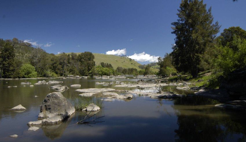
EMA
Eric Martin & Associates
West Belconnen European Cultural Heritage Report
NSW Neighbours
13108
1.0 INTRODUCTION
1.1 Background
The Riverview Group are developing a proposal for rezoning land in West Belconnen and adjacent NSW
for residential development. To assist this task they have requested research and investigation into the
area and preparation of a report on European Heritage. The overall site includes four distinct areas
divided by ACT and NSW land and land ownership.
1.2 Brief
A summary of the brief is outlined below with a full copy in Attachment 1. The initial brief was expanded to
include ACT Land Blocks 1605 and 1606.
1.2.1 Site
The site for this study is:
Lot 4 NSW 80 ha
Lot 5 NSW 80 ha
Lot 61 NSW 83 ha
Lot 62 NSW 25 ha
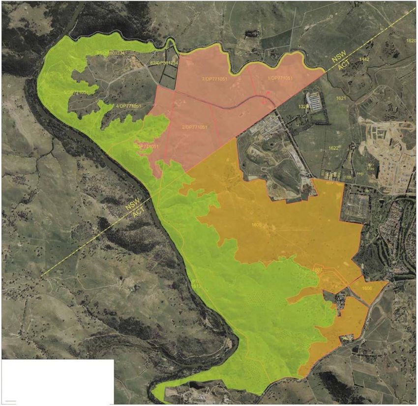
Refer Figure 1 for a plan of the overall site. The area included in this report (NSW Neighbours) is shown
in Figure 2 and Figure 3.
Figure 1: Plan of Overall Site
Source: The Riverview Group
W:\PROJECTS 16 2013\13108 West Belconnen Heritage Advice\E Draft Reports\20140217WBECHA NSW Neighbours FD iss 3.docx Page 3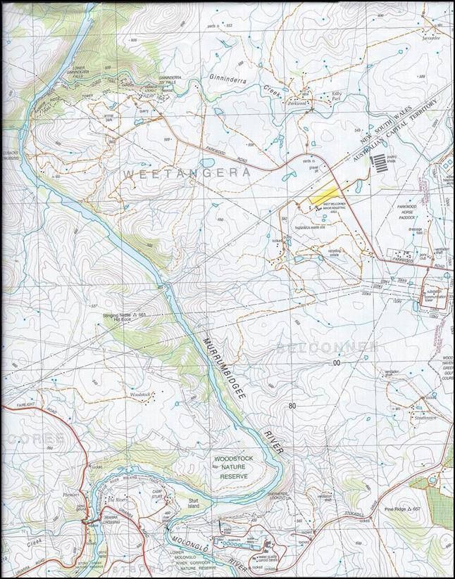
EMA
                                                                                                                       Eric Martin & Associates
                                                       West Belconnen European Cultural Heritage Report
                                                                                                                        NSW Neighbours
                                                                                                                                        13108

                                                     Figure 2: Plan showing NSW Neighbour Land

                 .

                                             Figure 3: Aerial View of NSW Neighbours
                                                Source: Google Earth accessed 4 December 2013

W:\PROJECTS 16 2013\13108 West Belconnen Heritage Advice\E Draft Reports\20140217WBECHA NSW Neighbours FD iss 3.docx                   Page 4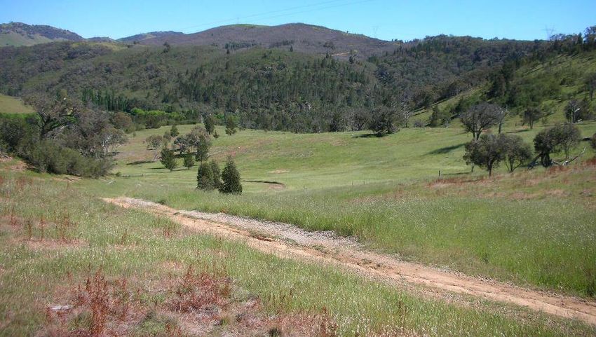
EMA
Eric Martin & Associates
West Belconnen European Cultural Heritage Report
NSW Neighbours
13108
1.2.2 Description
To undertake necessary research and investigations and prepare a report on the European
heritage of the study area.
The report to identify any features that are of heritage interest and provide an assessment of
appropriate options for the future management of such features in the context of urban
development.
Report to provide a commentary on the European heritage of the study area that may inform future
social and cultural planning for the proposed new community.
Report to provide sufficient information to substantiate proposals to rezone the land for urban
development including the identification of any requirements for heritage management or protection
that should be incorporated into rezoning proposals.
1.2.3 Methodology
The study adopts the principles and practices of Australia ICOMOS and will include:
Introduction
Historical background
Physical evidence and a
Assessment of significance.
If any significant item is identified then an appropriate statement of significance, opportunities and
constraints, conservation policies and management issues will be prepared. If significance does
not reach threshold for heritage registration there may be recommendations that guide future
development. These will be defined in this report.
1.3 Authorship
The report has been a collaborative effort by:
Conservation Architects Eric Martin & Associates Eric Martin
Historian Di-Petaia Research Dr Peter Dowling
Cultural Landscape Consultant Geoffrey Britton
1.4 Current Status
No part of the NSW Neighbours is listed on any heritage register or nominated for heritage listing.
1.5 Acknowledgement
We appreciated the assistance f David Maxwell of Riverview Group who arranged or assisted access to
the site and the individual owners/tenants of land who permitted site access.
1.6 Limitations
The report is restricted to European Cultural aspects. Indigenous Heritage is being assessed by Lyn
O’Brien from Biosis and natural heritage values by David Shorthouse and Kevin Mills.
It is worth noting that as a result of natural values a redefined river corridor has been established and this
is included as Figure 4.
W:\PROJECTS 16 2013\13108 West Belconnen Heritage Advice\E Draft Reports\20140217WBECHA NSW Neighbours FD iss 3.docx Page 5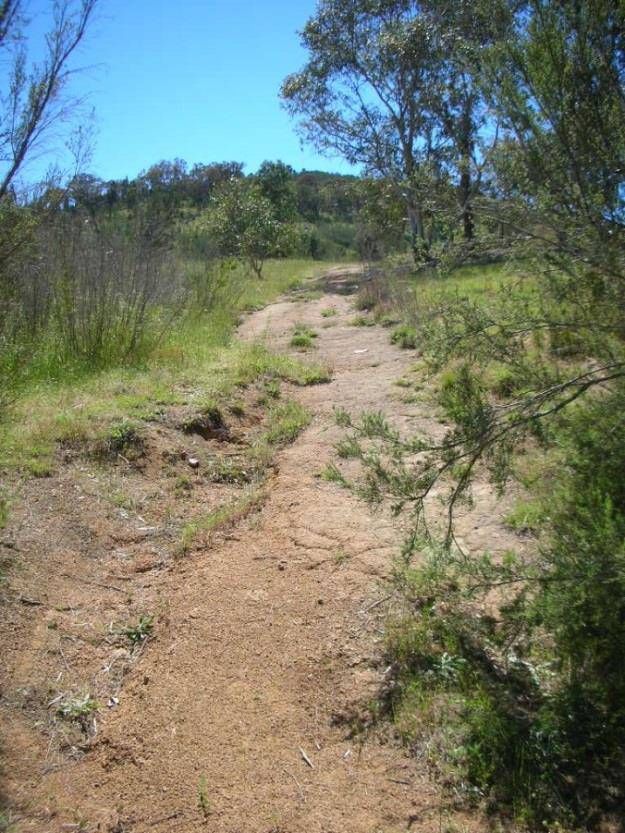
EMA
                                                                                                                       Eric Martin & Associates
                                                       West Belconnen European Cultural Heritage Report
                                                                                                                        NSW Neighbours
                                                                                                                                        13108

D PROPOSED URBAN AREA
D RIVERVIEW NSW LAND
D PROPOSED RIVER CORRIDOR

                                  Figure 4: Site Plan Showing Proposed River Corridor
                                          Source: The Riverview Group Knight Frank, J107868.02
                                          Cadstral Mapping Metadata Rev C (26 September 2013)

W:\PROJECTS 16 2013\13108 West Belconnen Heritage Advice\E Draft Reports\20140217WBECHA NSW Neighbours FD iss 3.docx                   Page 6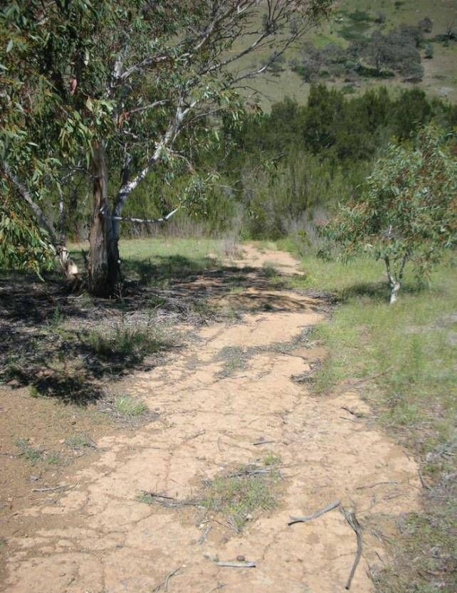
EMA
                                                                                                                           Eric Martin & Associates
                                                           West Belconnen European Cultural Heritage Report
                                                                                                                            NSW Neighbours
                                                                                                                                            13108

2.0 HISTORICAL BACKGROUND
2.1           European Exploration and Settlement
In the early years of the 1820s European explorers reached what is now the Australian Capital Territory.
Dr Charles Throsby, a former Naval Surgeon turned landholder and explorer, his nephew Charles
Throsby Smith, guided by his convict overseer, Joseph Wilde, and James Vaughn reached the Molonglo
River and the wide valley it flowed through. They were on their way to find the Murrumbidgee River.
After several setbacks, Throsby reached the River in 1821. Throsby and his party were the first
Europeans to see the Murrumbidgee River.

Following his explorations Throsby wrote of the country he had crossed:

                ...perfectly sound, well watered, with extensive meadows of rich land on either side of the
                rivers; contains very fine limestone, in quantities perfectly inexhaustible, slate sand-stone
                and granite fit for building, with sufficient timber for every useful purpose; and, from the
                                                                                      1
                appearance of the country, an unbounded extent to the westwards

Certainly overstating the natural resources available, Throsby’s description of the land he saw had an
element of accuracy (‘extensive meadows’) and when it was published in the Australian Magazine in 1821
it triggered much interest among the Sydney entrepreneurs. More tantalizing news of favourable lands
and profits to be made came soon after.

Following the Throsby expedition, Captain Mark Currie, accompanied by the reliable Joseph Wilde and
Brigade Major Ovens, reached the Molonglo River and turned south, reaching the Murrumbidgee in 1823.
Alan Cunningham and his party were the next to pass through the area in April 1824. Cunningham’s
objective was to make a detailed botanical inspection of the lands already seen by Throsby and Currie.
He followed the Molonglo and Murrumbidgee Rivers, covering some of the ground which Currie had
                         2
crossed the previous year .

Throsby, Currie and Cunningham reported back to the Colonial Government on the open and well-
watered lands they crossed; suitable, they claimed, for sheep and cattle grazing. At that time there were
great opportunities for those with an entrepreneurial flair and the financial backing to achieve their aims to
invest in tracts of land recently found on the western slopes of the Great Dividing Range. A rush to claim
these lands began. European settlement began on the flood plains and slopes above the Molonglo River
in what is today the central area of Canberra, and spread quickly south towards Tuggeranong and north
to the lands bordering Ginninderra Creek and the Murrumbidgee River.

2.2         Early Settlement
Robert Campbell, a prominent person in the commercial sphere of Sydney, was well connected to the
high social circles of the early colony through his family background and his wife Sophia, who was the
sister of John Palmer the Commissary-General and First Fleet arrival on the Governor Philip’s Ship HMS
Sirius. Campbell had received a land grant from the Governor of NSW to compensate for the loss of one
of his ships and in 1825 he had established a property at Pialligo on the Molonglo River with James
Ainslie as manager. The property was later named ‘Duntroon’, after the Campbell family properties in
Scotland. Robert Campbell most likely informed Palmer of the opportunities available for grazing
interests in the newly explored area of the colony. John Palmer and his son, George Thomas Palmer,
lost little time in establishing land – John in the area of Jerrabomberra adjoining Campbell’s holdings and
George Thomas further north in rolling plains bordering Ginninderra Creek know to the indigenous people
                              3
Ginninginninderry in 1826 .

These frontier properties were well beyond formal control of the colonial administration and formal
possession of lands often lagged behind actual possession. George Thomas Palmer, although grazing
the lands since 1826, did not submit a request for permission to purchase the land from the colony until
18 May 1829.

1
    Throsby in Australian Magazine June 1821.
2
    Havard, 1956.
3
    Gillespie, 1991, p6.

    W:\PROJECTS 16 2013\13108 West Belconnen Heritage Advice\E Draft Reports\20140217WBECHA NSW Neighbours FD iss 3.docx                   Page 7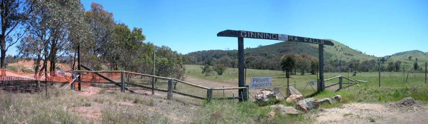
EMA
                                                                                                                                Eric Martin & Associates
                                                           West Belconnen European Cultural Heritage Report
                                                                                                                                 NSW Neighbours
                                                                                                                                                 13108
              I beg to request that you will be pleased to submit to His Excellency Governor Darling, my
              desire to obtain his permission (when the boundary may be extended) for the occupation of
              an extent of land (not within the line of its present demarcation) about seven miles distant
              to the northward of the property of Mr Campbell senior, in the vicinity of Limestone Plains,
              as it is my intention if allowed, to purchase to the full extent of the regulation which I
                                                                           4
              understand to be nine thousand six hundred acres[3885 ha)

Palmer then submitted a formal application for land on 14 December:
                                                                                                                           st
              With reference to that part of the Land Regulations (bearing dates the 1 August, 1831)
              headed “Leases”, I beg to state that I am desirous of renting fifteen sections of land
              situated at Ginginninderra [sic] in the neighbourhood of that quarter of the country
              commonly called the Limestone Plains and forming part of the quantity which I formerly
                                                              5
              made application to rent with a view to purchase .

The tyranny of distance affected the colonial administration in far off Sydney and a muddling bureaucracy
initially allocated the desired lands to Mr John Cartwright. An annoyed Palmer then pointed out that he
had occupied the lands for several years, had erected several expensive buildings and installed an
overseer. The confusion was quickly cleared up in Palmer’s favour by the Colonial Secretary and the
lands he requested were formally granted in 1831 five years after he had first taken up the land.

It would appear that none of Palmer’s local lands were surveyed before occupation, although Assistant
Surveyor Robert Dixon and his party had been in the district in 1829. Palmer’s holdings were eventually
surveyed in 1832, by Robert Hoddle and in 1836 by James Larmer.

Palmer’s holdings in the Ginninderra district included:

              Portions 4, 8, 9, 10 & 94 – Parish of Weetangera – 4,321 acres (1749 ha)

              Portions 4 & 34 – Parish of Wallaroo – 2,205 acres (892 ha)
                                                                                                                                    6
              Portions 20 [Palmerville] , 21, 22, & 23 – Parish of Canberra – 2,640 acres (1068) .

Further land grants were to be given in the larger area of Ginninderra but many were to absentee owners
who speculated but never settled the area [p. 9]. One such ‘speculator’ was John Langdon who obtained
a grant of 1, 280 acres (518 ha), never lived on it, and disposed of it to George Palmer in 1834 in
exchange for 445 ewes [p.9]. By this time Palmer was in formal possession of at least 4,227 ha of land
and utilising further land areas primarily for grazing in the Ginninderra Creek area.

Another more well-known speculator was Captain Charles Sturt who acquired property (‘Belconnen’) with
frontage on the Murrumbidgee as a reward for his explorations along the Murray and Murrumbidgee
Rivers. But, he sold it to Fredrick Campbell within one year. Fredrick Campbell also purchased 640 (259
ha) acres of land on Ginninderra Creek from George Popham in 1836 steadily increasing his land
holdings in the area. By the late 1830s the Campbell estate north of the Molonglo River and in the vicinity
of Ginninderra Creek totalled almost 6,900 hectares By this time Palmer was in formal possession of at
least 4,227 ha of land and utilising further land areas primarily for grazing.

Yet another absentee owner was Alick Osborne, a Royal Navy Surgeon, who obtained 987 acres (399
ha) on Ginninderra Creek at its junction with the Murrumbidgee. He sold the land for £1,200 to Thomas
Southwell, who named the property ‘Parkwood’ and immediately took up residence on it and stayed!

The pattern of absentee land owners selling their land grants to the larger land holders continued. One
exception, however, was Henry Hall who received a grant of 3,742 acres (1514 ha) in the parish of
Wallaroo and established his homestead there in 1833. His property, Charnwood was surveyed in Aril
1836.

4
    Ibid p.6.
5
    Ibid p.7.
6
    Land Titles Office, NSW, Plans M6.743, M44.743, M48.743, M50.743, M98.743, M100.743; Gillespie 1991 p.8.

    W:\PROJECTS 16 2013\13108 West Belconnen Heritage Advice\E Draft Reports\20140217WBECHA NSW Neighbours FD iss 3.docx                        Page 8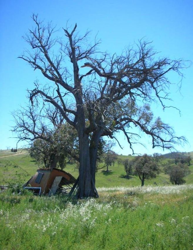
EMA
                                                                                                                           Eric Martin & Associates
                                                           West Belconnen European Cultural Heritage Report
                                                                                                                            NSW Neighbours
                                                                                                                                            13108
Following a census taken in 1841 the only habitations in the Ginninderra district appear to have been
those Palmer (Palmerville), Hall (Charnwood), Glenwood, and Campbell (Belconnen). An example of the
population in the area at this time can be derived from two properties:
                                                                                  7
Population in the Ginninderra district from 1841 census :
                   Property                                           Population

           Palmerville                   47 males, 21 females (total 68)
                                         15 were convicts
                                         6 were ticket-of-leave employees

           Charnwood                     24 males, 8 females (total 32)
                                         11 were convicts (10 male, 1 female)
                                         3 were ticket-of-leave employees

But, by the end of the 1850s the majority of the land north and south of Ginninderra Creek either side of
the present ACT-NSW border was held by a handful of wealthy owners including Campbell, Palmer,
Southwell and Hall, most of whom held lands elsewhere (refer Figure 7).

                                                               Figure 5: c1910 Map
            This map re-published as c1910 Map shows lands held by George Palmer (on both sides of the border),
            Alick Osborne (Block 36, Parkwood) and land attributed to Captain Charles Sturt. By the time this map
            was re drawn with the ACT/NSW border Sturt had sold his land to Fredrick Campbell, and Osborne had
                                              sold his to Thomas Southwell.
                                                                          Source:

2.3         The Charles Sturt period
Following his explorations along the Darling and Murray Rivers systems (1828-1830) and government
postings, Charles Sturt returned to England in poor health. While undergoing treatment he published an
account of his journeys, and after many petitions to the New South Wales Government for recompense,
he was promised a grant of 5,000 acres (2,024 ha). The promised grant came with a condition that he
gave up his military commission and renounced all other rights arising from his military service. Sturt’s

7
    Gillespie, 1991, p.12.

    W:\PROJECTS 16 2013\13108 West Belconnen Heritage Advice\E Draft Reports\20140217WBECHA NSW Neighbours FD iss 3.docx                   Page 9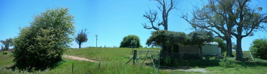
EMA
                                                                                                                           Eric Martin & Associates
                                                           West Belconnen European Cultural Heritage Report
                                                                                                                            NSW Neighbours
                                                                                                                                            13108
decision to resign from the military was no doubt based on his continuing ill health, poor eyesight and
                            8
strained financial situation .

Sturt and his wife returned to New South Wales in 1835. On 17 April 1835 Sturt wrote to his brother
William: You are aware that the Government gave me a 5,000 acre grant of land, but I have not as yet
made my selection, being puzzled as to the locality.

Just a few days later it would appear that Sturt had made up his mind on where to select his land. On 21
April he wrote again:

                 I am on the eve of making a journey to select my acres. The country to the south is
                 described by several people as most beautiful. As soon as I get my land I shall stock it
                 with 1,000 sheep and 150 to 200 head of fine cattle. As a beginning, that, I think, will do
                 very well; and a trip once or twice a year to see my establishment will be a pleasure to
                    9
                 me .

On 5 June an order was issued by the Governor for the promised grant of land. Just after their arrival
back in the Colony the Sturts purchased an additional 1,950 acres (789 ha) near Mittagong where they
settled. Sturt may have made a journey to the area of Ginninderra to select his granted land.

Sturt’s wife, Charlotte, wrote in her biography:

                 Sturt delayed for some time to select his land, and the Survey Office in Sydney warned
                 him they would cancel his grant if he did not exercise it within a given time. This notice
                 found him lying ill at Yarralumla, so on hearsay and in haste, he chose his grant at
                 Ginningdera [sic] near Queanbeyan, a block surrounded on three sides by the water of
                 the Murrumbidgee, the Queanbeyan [actually the Molonglo] and the Ginningdera. The
                                                                                  10
                 land, however, is not good, and has suffered heavily from floods ).

Writing many years later, Charlotte Sturt may have exaggerated the flooding of the land. While the
Murrumbidgee and Molonglo Rivers and Ginninderra Creek would have regularly flooded, much of the
land Sturt selected was and is today above the floodplains of these waterways.

Whether he did actually inspect the area, or relied on the recommendations of contacts in the district, the
land he selected for his grant was a good choice. The 5,000 acres was a gently sloping area of land with
sheltering ridges. The selection fronted on to the permanent water sources of the Murrumbidgee River,
and was bounded in the north by Ginninderra Creek and in the south by the Molonglo River. Small
drainage creeks and springs added to the water availability of the land (Figure 6).

The selection was surveyed by Robert Hoddle, the Deputy Surveyor General for the Colony, on 25
November, 1835 and gazetted on 8 February, 1836. Sturt was asked by the Colonial Secretary to name
his grant for the title deed:

                In reply to your communication requesting to be informed by what name I would wish the
                5000 acre grant confirmed on me by the Government to be designated that the same may
                be entered in the Title Deed which His Excellency the Governor had directed to be
                                                                                  11
                prepared. I have to express my wish that it may be called ”Grange” .

With the name of the property duly recorded the land was finally granted to Sturt on 3 February 1837.

Judging by the letter he had written to his brother on 17 April, Sturt most likely had no intention of actually
building and living on the Ginninderra land grant. By 1836 he and his wife had purchased and settled on
a property between Bowral and Mittagong. Sturt was to hold title of the ‘Grange’ for just a year. On 26
February 1838, he sold the whole 5,000 acres to Charles Campbell. There is no record of Sturt returning
to the Ginninderra region and he saw out his last years in Australia in Adelaide; living in a modest house
he named ‘Grange’ before returning to England in 1853.

8
  Cumpston ,1951; Beale, 1979.
9
  Cumpston ,1951.
10
   Cited in Cumpston, 1951.
11
   Archives Office NSW Microfilm No. 1185 cited in Gillespie, 1992.

    W:\PROJECTS 16 2013\13108 West Belconnen Heritage Advice\E Draft Reports\20140217WBECHA NSW Neighbours FD iss 3.docx                  Page 10
EMA
Eric Martin & Associates
West Belconnen European Cultural Heritage Report
NSW Neighbours
13108
However, the figure of Charles Sturt has been prominent in Australia’s history, particularly for his
explorations in the Murrumbidgee and Murray River Corridors and into the desert centre of the continent.
His name has been given to a suburb in Adelaide, a University in New South Wales, and several
municipal streets and roads, including the major highway linking South Australia, Victoria and the Hume
Highway in New South Wales. Sturt’s association, however fleeting it was, with the land along the
Murrumbidgee was locally and officially recognised into the early nineteenth century with ‘Sturt’s Grant’
being marked on the 1915 Feature Map produced by the Federal Capital Territory. Today, the Sturt
association is still recognised by the naming of Sturt Island in the Murrumbidgee Corridor.
Figure 6: The location of Sturt’s 5,000 acre land grant, later named ‘Belconnen’,
was between the Murrumbidgee River in the south and Ginninderra Creek to the
north.
The ACT-NSW border cut through the original grant leaving the northern section under
NSW legislation and retained in private ownership, and the southern section under
12
Commonwealth legislation to be compulsorily resumed . Part of the NSW Neighbours
land is depicted as a reserve area in the north from Ginninderra Falls and the northern
section of Sturt’s grant (later purchased by Fredrick Campbell).
Source: Cumpston, 1957.
2.4 The Campbell Period
Charles Campbell had come to the district to manage his father’s (Robert Campbell) station at Duntroon
in 1835. He briefly assumed responsibility for the management of George Thomas Palmer’s Ginninderra
Estate, marrying Palmer’s daughter, Catherine, in 1837. Following the sale of Sturt’s acres, Charles
Campbell arranged to buy his father-in-law’s Ginninderra property with a down payment and the balance
being paid by instalments. The deal did not last long, and Palmer resumed possession when his son-in-
law could not keep up the payments. A drought, along with falling wool and stock prices were the main
12
Cumpston, 1951.
W:\PROJECTS 16 2013\13108 West Belconnen Heritage Advice\E Draft Reports\20140217WBECHA NSW Neighbours FD iss 3.docx Page 11EMA
Eric Martin & Associates
West Belconnen European Cultural Heritage Report
NSW Neighbours
13108
causes. However, Charles and Catherine managed to hold on to Belconnen even though they moved
13
back into the family home at Duntroon . Belconnen became an outstation to the Duntroon estate.
Campbell did not keep the name of ‘Grange’ for his new acquisition, and soon after purchase the land
14
was named ‘Belconnen’. The origin of this name is not entirely clear but it has been suggested that
Campbell gave it this name following an incident on the property when an Indigenous male used a similar
sounding word, meaning “I cannot find”. The name, like many Indigenous terms adopted by Europeans,
has been spelled as ‘Belconnel,’ ‘Belconon’ and ‘Belcomon’. The name was largely limited to the
property and was not applied to the present area of Belconnen until after the Naval Transmitting Station,
built nearby in 1938/9, adopted the name.
Campbell’s staff set to work clearing the native vegetation, opening up the land for sheep grazing.
Campbell may also have planted exotic species.
Living in the Ginninderra district in the 1830s and 1840s meant an isolated and confined lifestyle. A
census taken in 1841 showed the only inhabitants of the area were from Palmer’s holdings, Charnwood
and Glenwood Stations and the Campbell holding of Belconnen. The total population was just over one
hundred and approximately seventy five percent were males. The isolation was especially telling for the
women, but there were some opportunities for socialising. The main social events in these times were
visiting other families and the Sunday church services. Catherine Campbell, while living at Duntroon,
15
often visited her father’s property and most likely, accompanied by her husband Charles, visited their
Belconnen holding.
By the end of the 1870s the Ginninderra region began to show signs of development, with the population
increasing following the passing of the Crown Land Acts (Roberson Land Acts) of 1861. Most of the
properties in the area were small, ranging from 40 to 400 acres (16-161 ha), although when Crace
purchased Charnwood he held around 20,000 acres (8093 ha).
Charles Campbell’s son, Frederick, took over the management of the Duntroon estate, including the
16
Belconnen outstation, in 1877 when his father was overseas . The second son of Charles and
Catherine, Frederick was born at Duntroon in 1846, the same year his grandfather, Robert, died.
Frederick was born with a cleft-lip and experienced difficulties with his speech throughout his life.
Embarrassed by his speech and having problems with his studies at Sydney University, Frederick
17
decided to try life on the land . He worked as a jackaroo in Queensland; and later in 1873, with financial
help from his uncle, purchased land near Walgett. Frederick experienced financial problems and sold out
two years later. He accepted an offer from his uncle, George Campbell, to manage Duntroon estate,
which he did for five years. Duntroon had become the centre for an elite society of established and
wealthy landowners. Frederick, now just in his thirties, did not fit easily into this society, most likely
because of his speech difficulties, and did not often entertain. But, nonetheless, he liked to be recognised
by the local communites as a Campbell. In 1878 he married into the elite society. His wife, Francis
Wright, was the daughter of James and Mary (nee Davis) Wright of Lanyon and Cuppacumbalong.
13
Gillespie, 1992.
14
Shepherd, 2005.
15
Gillespie, 1992.
16
ibid
17
Newman, 2007.
W:\PROJECTS 16 2013\13108 West Belconnen Heritage Advice\E Draft Reports\20140217WBECHA NSW Neighbours FD iss 3.docx Page 12EMA
Eric Martin & Associates
West Belconnen European Cultural Heritage Report
NSW Neighbours
13108
Figure 7: 1886 Index map of New South Wales showing pastoral holdings following the 1884
Crown lands Act prepared by the Surveyor General’s Office. The NSW Neighbours land south of
Ginninderra Creek and the surrounding land east of the Murrumbidgee are not yet subdivided.
Source: 1986 Index Map of New South Wales
In 1882 Frederick (or Fred as he was more widely known) finalised the purchase of Yarralumla Estate. At
that time, Yarralumla consisted of a collection of land grants and conditional purchases accumulated by
Augustus Gibbes. The land parcels were not adjoining and there was no single marked boundary to the
estate. To consolidate the estate holdings Frederick bought land areas lying between his scattered titles
with the object of clearly delineating the Yarralumla Estate. The Belconnen lands, which had passed to
Frederick following the death of his father, were incorporated in the Yarralumla Estate. The total estate,
now 39,000 acres (16,783 ha), also included land on the south side of the Molonglo, incorporating the
present ‘Huntly’ lands.
Frederick employed overseers and staff for his holdings. Fencing, stables and yards were erected during
18
the 1880s to 1890s by James Kilby and Evan Cameron . The Campbell family, starting with Robert
Campbell who established Duntroon, had a tradition of assisting Scottish migrants to Australia and
employing them on their holdings.
th
By the beginning of the 20 century Belconnen was prospering. The land within the study area appears
to have been exclusively used for sheep and cattle grazing with crops of oats, barley and wheat. The
farm buildings and main infrastructure, now located outside the study area within the ACT, included a
stone overseers’ cottage with slab attachments, sheep yards, animal enclosures and a shearing shed.
But within the first three decades of the 1900s the situation was to change.
18
ACT Heritage Council.
W:\PROJECTS 16 2013\13108 West Belconnen Heritage Advice\E Draft Reports\20140217WBECHA NSW Neighbours FD iss 3.docx Page 13EMA
Eric Martin & Associates
West Belconnen European Cultural Heritage Report
NSW Neighbours
13108
Figure 8: The map of the Federal Capital Territory Boundary Survey, republished
c1910, shows the rural holdings of the Weetangera and Canberra regions.
The study area region in the Weetangera Shire between the Murrumbidgee River and
Ginninderra Creek has been surveyed into large open grazing lots compared to other
smaller lots to the south.
(Note: The map is based on an earlier parish survey as the neighbouring lot labelled
under the ownership the ownership of Capt. Charles Sturt was sold to Campbell in
February 1838).
Source:
Figure 9: Expanded section of the above map showing the NSW Neighbours land (south of
Ginninderra Creek) as blocks 37, 7 and 74 held by George Thomas Palmer as part of a 1105 acre
(447 ha) holding.
Note: The map is based on an earlier parish survey as the neighbouring lot labelled under the ownership
of Alick Osborne was sold to Thomas Southwell in 1854; and the lot under the ownership of Capt. Charles
Sturt was sold to Campbell in February 1838.
Source:
W:\PROJECTS 16 2013\13108 West Belconnen Heritage Advice\E Draft Reports\20140217WBECHA NSW Neighbours FD iss 3.docx Page 14EMA
Eric Martin & Associates
West Belconnen European Cultural Heritage Report
NSW Neighbours
13108
Following the Federation of the Australian colonies in 1901, and the eventual selection of the Canberra
area as the site of the new Federal Capital in 1908, the Federal government was anxious to accurately
survey the new Capital Territory. Under the guidance of Charles Scrivener who was appointed Director of
the Lands and Survey Department, the surveying of the border began in 1910. The first section to be
surveyed was along a direct bearing between the summits of Mount Coree and One Tree Hill. The
survey line cut through Campbell’s Belconnen property putting the southern two-thirds of the land within
the new Federal Territory and subject to compulsorily resumption. Campbell was left with the northern
third of the property within New South Wales and under his ownership. As well as Belconnen, all of the
Duntroon estate lands within the borders of the Federal Capital Territory were to be subject to
government acquisition. Campbell was also to lose his family home of Yarralumla, which became home
to Australia’s Governors’ General.
Frederick Campbell had been a great supporter of the Yass/Canberra area as the site of the new Federal
Territory and advocated strongly for it. But when he the border was to be surveyed cutting through his
holdings he was most distressed and angered by the impending government land acquisitions. Referring
to the Belconnen land he had purchased from Sturt, he wrote to Scrivener in August 1912 wishing to
retain the lands in the Federal Territory:
It is my Ewe Lamb, and I hope the Commonwealth Government will be satisfied to leave me
19
that much of Sturt’s 5000 acre grant and not drive me altogether out of my native district .
His plea was not fulfilled and the estate lands were acquired by the Federal Government leaving the small
New South Wales portion north of the border in his ownership. Frederick Campbell, in great
disappointment at losing title of his lands moved away from Yarralumla and the Federal Capital. He died
in 1928. The Canberra Times wrote in its obituary:
Mr Campbell’s association with Yarralumla dated from 1881, when he bought that
property from the Gibbes family. Yarralumla comprised about 8,000 acres, and when he
received his father’s property at Belconon on the latter’s death, in 1888, he owned about
20,000 acres freehold. Under his direction Yarralumla became a model station. Heavy
forest land was converted into grazing and cultivation paddocks, marshy country was
dried by about 500 miles of drains, and the whole area was made practically rabbit-proof.
The clip, from Merinos of Boonoke and Wanganella extraction, became one of the most
valuable in the State.
Mr Campbell resided at Yarralumla until it was resumed as a residence for the Governor-
General, and then left to control Cooinbil, a property he had acquired in Riverina. During
his residence in the present Federal Territory he took a keen interest in all local affairs.
For many years he was a member of the Queanbeyan pastures Protection Board, and for
some time also was president of the local branch of the Farmers’ and Settlers’
20
Association .
2.5 A New Era
2.5.1 The Kilby family at The Falls and Parkwood
Following on from Thomas Palmer, Charles Sturt, Charles and Frederick Campbell, James Kinloch
Kilby farmed blocks 37, 7 and 74 (the NSW Neighbours land area). Kilby was born in 1870, the
son of Robert and Jane Kilby who emigrated from England and arrived in Sydney in 1856. The
senior Kilby’s soon found their way to the Ginninderra district and set up the grazing station, ‘Lands
End’, now in the Canberra suburban area of Weetangera. James Kilby married Beatrice Southwell,
daughter of Thomas and Mary Southwell of ‘Parkwood’ in 1897 continuing a close association
which had developed between both families in the often isolated rural area.
On 7 February, 1895, James Kilby acquired the land overlooking the junction of Ginninderra Creek
and the Murrumbidgee as a conditional purchase from the Crown. The property comprised an area
of 222 acres (90 ha) and was on the southern side of the Ginninderra Creek including Ginninderra
21
Falls . Conditional Purchases were introduced in 1862 under the Robertson land Acts as a way
19
NAA A371.1.
20
Canberra Times, 1928.
21
Winch, 1982.
W:\PROJECTS 16 2013\13108 West Belconnen Heritage Advice\E Draft Reports\20140217WBECHA NSW Neighbours FD iss 3.docx Page 15EMA
Eric Martin & Associates
West Belconnen European Cultural Heritage Report
NSW Neighbours
13108
of getting small landholders on the land. Buyers selected a portion of land, paid an initial deposit of
10 percent of the value, and then had to pay it off in instalments. The main conditions were that
they had to reside on the property, and they had to improve it – build a house, plant crops and run
livestock. On 3 May 1900, five years after purchase the conditions having been met the purchase
of the land became complete. James and Beatrice Kilby lived there for eight years. James and
Beatrice called their small holding ‘The Falls’ after Ginninderra Falls.
Figure 10: ‘The Falls’, residence of James and Beatrice Kilby. Left to right are Beatrice
Kilby with baby Keith, Jane Kilby, Robert Kilby, James Kilby, Edith Kilby and
children Roy and Harry Vest.
Source: Gillespie, 1992
The association between the Kilby and Southwell families was to endure for many years and over
several generations, particularly with the ownership and occupation of Parkwood lands which
bordered ‘The Falls’. Ten years after purchasing ‘The Falls’ and with the purchase price well and
truly paid James and Beatrice Kilby acquired the now well-known property of ‘Parkwood’ from
Edwin Davis. There was 987 acres (400 ha) in this purchase. Parkwood had been the home of
Thomas and Eliza Southwell, Beatrice’s parents, which they had set up in1854. Following the
death of Thomas Southwell the property had between subdivided between his four eldest sons in
acknowledgement of their part in establishing ‘Parkwood’. However, the youngest Southwell son,
Mark, bought his brothers out and he remained there until 1905 when a sever bushfire burnt out
most of the property. ‘Parkwood’ was then sold to Edwin Davis and for five years (1905-1910) was
out of the hands of the Southwell Family. This must have distressed the Southwell family,
particularly Beatrice living on ‘The Falls’ just a few paddocks away so to speak. With the
necessary capital in hand, and ‘The Falls’ in their ownership, James and Beatrice Kilby purchased
‘Parkwood’. The Southwell Brothers moved back into the ‘Parkwood’ lands and the combined
properties were managed by a consortium, Kilby Brothers, Parkwood. The property was to remain
under the Kilby and Southwell ownership until 1969 when all but 40 acres (16 ha) was sold to
Mathew Abell & Co, Harwicke Stud. ‘Parkwood’ was again sold to a private ownership in 1984.
James Kilby and his family became prominent agriculturalists and social leaders in the region along
with the Southwells. Kilby supported many sporting clubs, became president of a local football club
and for a short period stepped in as a relief teacher of the Weetangera School when the resident
22
teacher took sick leave . Following his death in 1950 the Canberra Times stated:
In his early days he gave his services as a Sunday Schoolteacher. He was a member
of the choir, and a local preacher. For the past 50 years he has been Secretary of the
Wattle Park Church Trust. We are thankful to have had the influence of J.K. Kilby
23
among us .
The new era of land ownership and tenure in the districts surrounding and within the new Federal
Capital did not begin well for the owners. Many of Australia’s worst droughts occur when one or
22
Ibid
23
Canberra Times, July 24, 1950.
W:\PROJECTS 16 2013\13108 West Belconnen Heritage Advice\E Draft Reports\20140217WBECHA NSW Neighbours FD iss 3.docx Page 16EMA
Eric Martin & Associates
West Belconnen European Cultural Heritage Report
NSW Neighbours
13108
24
two dry years follow several years of below average rainfall . The five years leading up to 1900
saw dry spells across most of the country followed by reasonable rains in 1900 and 1901. But with
the coming of Spring in 1901 extremely dry weather returned across eastern Australia. It was
called the Federation Drought. The erratic weather conditions caused seven years of severe
drought and hardship for the land holders along the Ginninderra Creek catchment. The drought
conditions saw crop failures and farm incomes fall. To make matters worse a rabbit plague and a
grasshopper plague coincided with the drought and what grasses were able to survive in the dry
grounds were consumed. In a cooperative rabbit drive on James Kilby’s property, three hundred
25
and fifty rabbits were killed in one day . As the farm incomes fell year by year the land owners
were forced to take out mortgages on their holdings, stock, and crops many of which were already
under mortgage contracts. The result was disastrous for many.
Samuel Southwell, James Kilby’s brother-in-law, recounted the farming experience in the 1840-60s
on the bordering Parkwood station:
My early knowledge of things generally in this district are that times were very bad for
people on the land and for all people who were trying to lead an honest life.
The only method to break up the land for farming pursuits was by single furrow plough
and bullocks. Reaping with sickle and thrashing by flail. Waiting for suitable wind to
clean the grain. With a very good market running wheat worth from 1/6 to 2/1
[shillings/pence] per bushel [,] hay worth very little and very little grown. Potatoes and
corn were grown but no market at all for such products. Good fat cattle now worth up to
£20 – per head were then only worth about £2 – horses very scarce and draughts were
out of the question.
Nearly every squatter carried on boiling down works, to use up the surplus fat stock
because there was no market for the stock. Very few had any sheep here in those
days. Wages were very low £20 per annum was then a fair wage. Young men received
about 5/- weekly as farm labourer. I saw a new bullock dray sold in the market for the
sum of £10 – worth from £40 to £60 now.
Later in years after the diggings broke out in Bendigo – Ballarat and other places all was
changed in the matter of produce and wages. Wheat went up to 16/- per bushel and
many carriers were employed to convey wheat to the Sydney market and elsewhere
which appears to have been the turning of the tide with men on the land. Since then to
now the times have been somewhat better or worse. Just as the circumstances and
26
seasons have occurred and occasioned.
In 1882 the larger landholders in the Ginninderra region, Edward Crace and Fredrick Campbell,
embarked on a large-scale fencing programme of their properties. Prior to this time properties
were largely unfenced and often the exact boundaries were uncertain. This situation necessitated
the employment of shepherds to control the sheep flocks during the day and yarding them at night
to reduce the risk of them straying or falling prey to wild dogs and dingoes. Fencing large areas
solved this problem to a large extent and was seen as financially expedient.
But fencing caused other problems. The smaller selectors had often the need to use the
established tracks across the properties of Crace and Campbell to get to their own holdings. This
was made even more a necessity because the holdings in the Ginninderra area were bordering or
spanning rivers such as the Murrumbidgee and Molonglo or smaller but often impassable water
ways such as Ginninderra Creek, particularly in the lower gorge reaches. The programme of
fencing by Crace and Campbell cut off these access routes along the tracks and caused bitter
disputes which led in many cases to legal disputes over rights of access.
‘The Falls’ below Ginninderra Creek and adjacent area (Lot 61) is now in private ownership/
occupation (Hyles). A residence (Lot 5, Gib Moore) has been built above the flood levels of the
Murrumbidgee, a few hundred metres from Cusack’s Crossing and the land is used for grazing as it
has since European arrival. Another residence (Shaw and Armitage) has been built on Lot 4.
24
Australian Bureau of Meteorology www.bom.gov.au/lam/climate/levelthree/c20thc/drought1.htm
25
Gillespie, 1992.
26
Samuel Southwell, 1920, cited in Winch ,1982, P.23.
W:\PROJECTS 16 2013\13108 West Belconnen Heritage Advice\E Draft Reports\20140217WBECHA NSW Neighbours FD iss 3.docx Page 17EMA
Eric Martin & Associates
West Belconnen European Cultural Heritage Report
NSW Neighbours
13108
Figure 11: Parish base map of Wallaroo (Weetangera),c. 1890s showing the study area,
top left of map, under the ownership of J.K. Kilby
Source: NSW Land & Property http://images.maps.nsw.gov.au/pixel.htm
st
2.5.2 21 Century
The area now is primarily open grazing lands for cattle and sheep with some small private
businesses. Ginninderry Homestead, a family owned Bed & Breakfast and functions centre at 468
Parkwood Road, was opened in 2001 on former grazing land privately purchased in 1989 and the
adjacent Pacispa Day Retreat is operated by the same family group.
Figure 12: Parish base map of Wallaroo, NSW, 1912, showing land within the study area.
Block 37 of 91 acres (37 ha) and block 74 of 529 acres (214 ha) are now owned by the
Commercial Banking Company of Sydney, formerly held by J.K. Kilby. Block 7 of 222
27
acres (90 ha) shows that it is at this time held by J.K. (James Kinloch) Kilby
Source: NAA A6273
27
NAA A6273 Lands in the Parish of Ginninderra Compulsory Acquisition 11-9-15
W:\PROJECTS 16 2013\13108 West Belconnen Heritage Advice\E Draft Reports\20140217WBECHA NSW Neighbours FD iss 3.docx Page 18EMA
Eric Martin & Associates
West Belconnen European Cultural Heritage Report
NSW Neighbours
13108
3.0 PHYSICAL EVIDENCE
3.1 Setting/Landscape
The allotments comprising the NSW Neighbours area encompass a mostly open, undulating and
predominantly grassy landscape, with scattered woodland trees, that is bounded by Ginninderra Creek to
the north and the Murrumbidgee River to the south and west. The eastern boundary initially follows the
eastern-most pine shelterbelt at ‘Ginninderry’ fronting Ginninderra Creek then turns west along the
Parkwood Road before following a meandering line to the southwest down to the Murrumbidgee River.
The whole of the study area is on an elevated plateau with a corresponding ‘shoulder’ on the other side of
the Murrumbidgee River where the river course has cut its way through both flanks and left the dramatic
and densely vegetated gorge. Chains of hills and mountains enclose the area in a broad arc from the
north and around to the west and south.
There are three principal creeks within the site all draining to the Murrumbidgee River and many more
subsidiary creeks. Landforms contrast between generally flat, gently undulating topography across the
northern third to more rolling, heavily incised country to the south, especially as it approaches the
Murrumbidgee River (refer Figure 13). Dense indigenous vegetation remains along the southern side of
Ginninderra Creek as well as the steeper southerly facing slopes of the more incised landforms –
including along the Murrumbidgee River gorge.
Figure 13: General view from Gib Moore’s property at the southwest corner of the study area showing
the rolling nature of the topography and the Murrumbidgee River valley in the middle ground where a
dense band of riparian vegetation is evident. The access road at right comes from adjacent the gravel
quarry at the end of Parkwood Road.
As a result of millions of years of geomorphological processes the study area possesses many
impressive vistas and views to the various waterforms along its edges – from the Murrumbidgee River
gorge to the various falls of Ginninderra Creek.
Neighbouring farm groups of note lie nearby including the Parkwood/Kilby Park group across Ginninderra
Creek to the northeast and, across the ACT border, Belconnen Farm to the southwest.
Apart from introduced vegetation associated with more recent buildings within the study area, most of the
vegetation is dominated by locally indigenous types relating to either the woodland community (Box/Gum
alliance) or riparian communities. Land associated with the recent building complex ‘Ginninderry’ is
divided into small paddock compartments and enclosed by lines of Monterey Pine (Pinus radiata). A
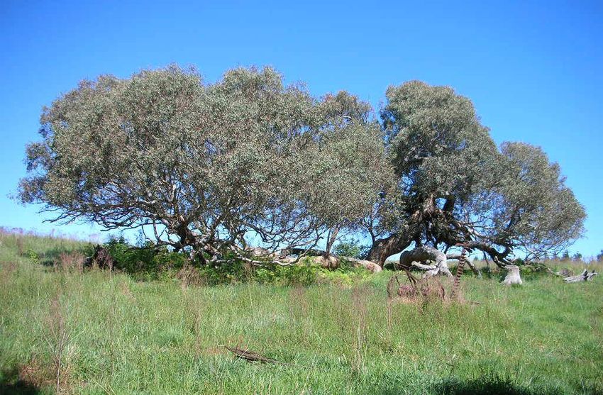
northerly paddock compartment includes an old woodland tree (red gum?) that has collapsed into a
sprawling diminutive forest (Figure 14).
To the southwest of ‘Ginninderry’ is a small commercial industrial area of where Ginninderra porphyry is
quarried for gravel.
W:\PROJECTS 16 2013\13108 West Belconnen Heritage Advice\E Draft Reports\20140217WBECHA NSW Neighbours FD iss 3.docx Page 19EMA
Eric Martin & Associates
West Belconnen European Cultural Heritage Report
NSW Neighbours
13108
Figure 14: A view of the entry track to Gib Moore’s property looking to the Murrumbidgee River
valley. At the right side in the middle ground is a fenced track running along the cleared slope in
the middle of the photograph. This is a section of the early right of way to Cusack’s Crossing that
appears on the parish map of 1904.
Source: G Britton, 2013
Figure 15: Figure 16:
Views of the old track to Cusack’s Crossing at the Murrumbidgee River through land within Gib
Moore’s property.
Source: G Britton, 2013 :
W:\PROJECTS 16 2013\13108 West Belconnen Heritage Advice\E Draft Reports\20140217WBECHA NSW Neighbours FD iss 3.docx Page 20EMA
Eric Martin & Associates
West Belconnen European Cultural Heritage Report
NSW Neighbours
13108
Figure 17: Former entry to Ginninderra Falls through private property at the end of Parkwood
Road. The entry portal features an impressive horizontal hardwood beam. Ginninderra Creek is
within the band of vegetation at the foot of the cleared hills in the background.
Source: G Britton, 2013
Figure 18: Part of the site featuring a former railway carriage with its exotic vegetation of
Ceanothus (in blue flowers), cypresses and Hawthorne.
Source: G. Britton, 2013
Figure 19: View within
the study area showing a
collapsed structure near
a senescent woodland
tree in the vicinity of the
building group with the
railway carriage.
Source: G. Britton, 2013
W:\PROJECTS 16 2013\13108 West Belconnen Heritage Advice\E Draft Reports\20140217WBECHA NSW Neighbours FD iss 3.docx Page 21EMA
Eric Martin & Associates
West Belconnen European Cultural Heritage Report
NSW Neighbours
13108
Figure 20: View over the railway carriage group showing the nature of the study area’s
topography – ranging from gently undulating to the north then becoming more rolling and more
deeply incised to the south towards the Murrumbidgee River valley. The all-pervading distant
ranges are also evident.
Source: G Britton, 2013
Figure 21: Collapsed old woodland tree within a northerly paddock enclosed by recent pine
plantations at the ‘Ginninderry’ property near Ginninderra Creek.
Source: G Britton, 2013
3.2 Evolution of the Cultural Landscape
Enduring intrinsic attributes of the landscape that would have been present at the time of the first
th
European incursions into the northern ‘Limestone Plains’ in the 19 century include the eroded and
weathered landforms, the dendritic drainage patterns, rocky gorges, sporadic persistent woodland trees
with a riparian vegetation community closer to the main drainage corridors and, in a broader context,
extensive views connecting the study area with the enclosing hills and mountain ranges beyond.
W:\PROJECTS 16 2013\13108 West Belconnen Heritage Advice\E Draft Reports\20140217WBECHA NSW Neighbours FD iss 3.docx Page 22EMA
Eric Martin & Associates
West Belconnen European Cultural Heritage Report
NSW Neighbours
13108
Where creeks and their tributaries have incised through the undulating landscape they have exposed
rocky terrain of mainly volcanic origin from the Hawkins and Laidlow Volcanic Suites. This is especially
noticeable as the creeks approach the Murrumbidgee River. The broader Belconnen-Ginninderra area is
28
also known to be of considerable geological and geomorphological interest.
The spectacular riparian scenery within the gorges of the Murrumbidgee River and Ginninderra Creek has
been long admired with the latter, for example, being the subject of paintings and photography from the
th
19 century (refer Figure 22 - Figure 24).
Figure 22: 1875 painting of “The Ginindarra Creek, looking to Murrumbidgee hills, County Murray,
NS Wales” by Constance Frederica Cumming (1837-1924)
Source: http://trove.nla.gov.au/version/21830258
28
Geological Society of Australia, A Geological Guide to the Canberra Region and Namadgi National Park, GSA Canberra
Division, 2008; Geosciences Australia, Geology & Geophysics, Geological maps !:100,00 series, Canberra Sheet 1992 and
Brindabella Sheet 1979; Department of Urban Services, Murrumbidgee River Corridor Management Plan, Conservation Series
No. 12, Australian Capital Territory Government, 1998, p. 74.
W:\PROJECTS 16 2013\13108 West Belconnen Heritage Advice\E Draft Reports\20140217WBECHA NSW Neighbours FD iss 3.docx Page 23EMA
Eric Martin & Associates
West Belconnen European Cultural Heritage Report
NSW Neighbours
13108
Figure 23: Undated Kerry & Co, “Ginninderra Figure 24: De Salis children at Ginninderra
Falls” Falls c 1893
Source: http://trove.nla.gov.au/version/172444946 c. 1893 Source: http://trove.nla.gov.au/version/456751170
Land included within the NSW Neighbours area is a close continuum of that within the ACT that has been
described as a Tableland Dry Tussock Grassland with Tableland Riparian Woodland along the
Murrumbidgee River (and into the larger tributary creeks) and patchy areas of Tableland Grassy
Woodland with Blakely’s Red Gum and Yellow Box) and Tableland Woodland with Black Cypress Pine
29
(Callitris endlicheri).
All of the NSW Neighbours area is outside the area that was once part of Charles Sturt’s 1837 land grant.
However the northwestern boundary of this grant is actually still delineated within the present landscape
and is interpreted by way of a fence alignment and pines extending from Ginninderra Creek along the
eastern edge of ‘Ginninderry’. The grant boundary line soon became the western boundary line of
Charles Campbell from 1838 and it was likely during the Campbell period (1838-1912) that it was initially
fenced. (As late as 1904, the map for the Parish of Weetangera still noted the Charles Sturt grant area
under his name.) The pine windbreak reinforcing this boundary of the study area was planted from the
1980s.
Aerial photography from 1985 (refer Figure 25) shows Parkwood Road within the study area to be largely
consistent with the present alignment although since 1985 the gravel quarry site has more than doubled
in area. Current aerial photography clearly shows an earlier access easement in the southwestern part of
the site that accords with the access, shown on the 1904 parish map, that led to the Cusack’s Crossing
site at the Murrumbidgee River near its confluence with Tinkers Creek on the opposite side. This earlier
access appears to be one of the few cultural landscape elements remaining from the Kilby period of
occupation of this land. Other features may also remain (for example evidence associated with the first
Kilby site ‘The Falls’), however access to most of the northern and the northwestern parts of the study
area was not possible.
29
Environment and Recreation, Territory and Municipal Services, ACT Aquatic Species and riparian Zone Conservation
Strategy, Action Plan No. 29, TAMS, Canberra, 2007, p. 29
W:\PROJECTS 16 2013\13108 West Belconnen Heritage Advice\E Draft Reports\20140217WBECHA NSW Neighbours FD iss 3.docx Page 24EMA
Eric Martin & Associates
West Belconnen European Cultural Heritage Report
NSW Neighbours
13108
Figure 25: 1985 Aerial Photograph
Source: NLA Belconnen CAC/C 2777 Run 2 Frame 035, 1985
Building groups within the southern parts of the study area – near the Cusack’s Crossing site and at the
head of the southerly creek line – have each been established in recent decades and each involve some
introduced vegetation that has remained confined to the immediate development area. The former site
has a small vineyard within a cleared area to the north of the main house group.
3.3 Structures
There are several structures in the study area as outlined below. Their location is shown in Figure 26.
10
9
8
LEGEND
11 1 Yards (Gib Moore)
2 Shed (Gib Moore)
3 Residence (Gib Moore)
1 5 4 4 Container (Shaw and Armitage)
3 2 7 5 Yards (Shaw and Armitage)
6 6 Residence (Shaw and Armitage)
7 Shed (Shaw and Armitage)
8 Quarry and Falls
9 PACISPA
10 Ginninderry
11 Site of Old Kilby Cottage.
Figure 26: Location of Structures
W:\PROJECTS 16 2013\13108 West Belconnen Heritage Advice\E Draft Reports\20140217WBECHA NSW Neighbours FD iss 3.docx Page 25EMA
Eric Martin & Associates
West Belconnen European Cultural Heritage Report
NSW Neighbours
13108
Source:
3.3.1 Yards (Gib Moore)
Metal post and rail yards and race.
3.3.2 Shed (Gib Moore)
Colourbond three bay shed with gable roof.
3.3.3 Residence (Gib Moore) c1985
A timber weatherboard cottage with Colourbond roof and an adjacent timber
weather board garage/workshop. There is a small garden shed and a large metal
tank on the hill behind the house. The residence is located beside the
Murrumbidgee River but above normal flood levels with minimal landscape other
than the natural landscape along the river.
W:\PROJECTS 16 2013\13108 West Belconnen Heritage Advice\E Draft Reports\20140217WBECHA NSW Neighbours FD iss 3.docx Page 26EMA
Eric Martin & Associates
West Belconnen European Cultural Heritage Report
NSW Neighbours
13108
3.3.4 Container (Shaw & Armitage)
A container sits in the paddock and is used for storage.
3.3.5 Yards (Shaw & Armitage)
Galvanised steel pipe rails to yard and race.
W:\PROJECTS 16 2013\13108 West Belconnen Heritage Advice\E Draft Reports\20140217WBECHA NSW Neighbours FD iss 3.docx Page 27EMA
Eric Martin & Associates
West Belconnen European Cultural Heritage Report
NSW Neighbours
13108
3.3.6 Residence (Shaw & Armitage)
A cottage has been created from an adapted railway carriage with the addition of a timber framed
porch clad in shadecloth.
There is a Colourbond double garage with a gable roof. A tent provides shelter to a boat. The area
is fenced with minimal landscape.
W:\PROJECTS 16 2013\13108 West Belconnen Heritage Advice\E Draft Reports\20140217WBECHA NSW Neighbours FD iss 3.docx Page 28You can also read