Habitat Regulations Assessment: Elstead and Weyburn Neighbourhood Development Plan - Elstead Parish Council
←
→
Page content transcription
If your browser does not render page correctly, please read the page content below

Habitat Regulations
Assessment: Elstead and
Weyburn Neighbourhood
Development Plan

Elstead Parish Council

March 2021
Habitat Regulations Assessment: Elstead and                                                                 Elstead Parish Council
Weyburn Neighbourhood Development Plan

Quality information
Prepared by                        Checked by                    Verified by                        Approved by

Hannah Corrigan                    James Riley                   Max Wade                           James Riley
Graduate Ecologist                 Technical Director            Technical Director                 Technical Director

Revision History
Revision               Revision date          Details           Authorized            Name                 Position

0                      January 2021           Draft             JR                    James Riley          Technical Director

1                      March 2021             Final following   JR                    James Riley          Technical Director
                                              group review

Distribution List
# Hard Copies          PDF Required           Association / Company Name

Prepared for: Elstead Parish Council                                                                                     AECOM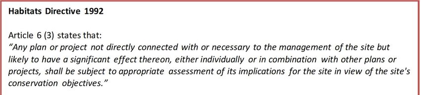
Habitat Regulations Assessment: Elstead and                                                     Elstead Parish Council
Weyburn Neighbourhood Development Plan

Prepared for:
Elstead Parish Council

Prepared by:

AECOM Infrastructure & Environment UK Limited
Midpoint, Alencon Link
Basingstoke
Hampshire RG21 7PP
United Kingdom

T: +44(0)1256 310200
aecom.com

© 2020 AECOM Infrastructure & Environment UK Limited. All Rights Reserved.

This document has been prepared by AECOM Infrastructure & Environment UK Limited (“AECOM”) for sole use
of our client (the “Client”) in accordance with generally accepted consultancy principles, the budget for fees and
the terms of reference agreed between AECOM and the Client. Any information provided by third parties and
referred to herein has not been checked or verified by AECOM, unless otherwise expressly stated in the
document. No third party may rely upon this document without the prior and express written agreement of
AECOM.

Prepared for: Elstead Parish Council                                                                         AECOM
Habitat Regulations Assessment: Elstead and                                                                                                 Elstead Parish Council
Weyburn Neighbourhood Development Plan

Table of Contents
1.           Introduction ...................................................................................................... 5
Legislation ........................................................................................................................................................ 5
2.           Methodology .................................................................................................... 7
Introduction ...................................................................................................................................................... 7
HRA Task 1 – Likely Significant Effects (LSE) .................................................................................................... 7
HRA Task 2 – Appropriate Assessment (AA) ...................................................................................................... 8
HRA Task 3 – Avoidance and Mitigation............................................................................................................. 8
Confirming Other Plans and Projects That May Act ‘In Combination’ ................................................................... 9
3.           Internationally Designated Sites .................................................................... 10
Thursley, Hankley and Frensham Commons SPA ............................................................................................ 10
Thursley, Ash, Pirbright and Chobham SAC ..................................................................................................... 12
Thursley and Ockley Bogs Ramsar.................................................................................................................. 13
Wealden Heaths Phase 2 SPA ........................................................................................................................ 14
Thames Basin Heaths SPA ............................................................................................................................. 15
Ebernoe Common SAC................................................................................................................................... 16
The Mens SAC ............................................................................................................................................... 18
4.           Likely significant effects ................................................................................. 21
Background to Elstead Parish ......................................................................................................................... 21
Physical Scope of the HRA ............................................................................................................................. 21
5.           Consideration of Effect ‘in combination’ ......................................................... 31
6.           Appropriate assessment ................................................................................ 32
Introduction .................................................................................................................................................... 32
Urbanisation ................................................................................................................................................... 32
Air quality ....................................................................................................................................................... 33
Recreational pressure ..................................................................................................................................... 35
Water quality................................................................................................................................................... 38
Hydrological changes...................................................................................................................................... 39
Habitat fragmentation...................................................................................................................................... 40
7.           Conclusion ..................................................................................................... 42

Figures
Figure 1: Four Stage Approach to Habitats Regulations Assessment. Source GOV.UK, 2019. ............................. 7
Figure 2. Bright et al (2007): Likelihood of a heathland patch being occupied in relation to the area of heathland.
...................................................................................................................................................................... 41

Tables
Table 1. How each European Site could be susceptible to the above impact pathways due to increased
development within Elstead. ............................................................................................................................ 23
Table 2. Screening assessment of the Elstead Neighbourhood Plan. ................................................................ 26
Table 3. Roads that are within 200m of each European Sites. Red shading identifies roads located within Elstead
and yellow shading identifies roads directly connected to Elstead. .................................................................... 34

Prepared for: Elstead Parish Council                                                                                                                         AECOM
Habitat Regulations Assessment: Elstead and                                                         Elstead Parish Council
Weyburn Neighbourhood Development Plan

1. Introduction
1.1     AECOM was appointed by Elstead Parish Council to assist in undertaking a Habitats Regulation
        Assessment (HRA) for the Elsead and Weyburn Neighbourhood Plan (NP). This is to inform Elstead parish
        Council and Waverley Council of the potential effects of NP development to European Sites and how they
        are being addressed in the Neighbourhood Plan, for that Council to take into account in their formal HRA.

1.2     The Waverley Local Plan Part 1 and Part 2 (LP) were subject to HRA in 2018 and updated in 2019. The
        primary conclusion of those HRAs was a need to address urbanisation and recreational pressures to the
        Special Protected Areas (SPA), Special Areas of Conservation (SAC) and Ramsar (protected wetland) sites
        located within the Waverley boundary as a result of development allocations. The HRA recommended policy
        mechanisms for this that are reflected in the adopted Local Plan.

1.3     The Waverley LP HRA considered both allocations made in Local Plan Part 1 and the overall quantum of
        development expected across the district over the Local Plan period. This included an allowance for 160
        dwellings at Elstead and Weyburn, of which approximately 100 have now been delivered, with the remainder
        to be allocated in the Neighbourhood Plan). The LPP1 HRA also included a windfall allowance for Waverley
        District. The total quantum of growth in Elstead & Weyburn has therefore already been assessed in
        combination with growth across Waverley and attributable to other plans and projects as part of the HRA of
        the Waverley LPP1. However, the specific locations of development for Elstead & Weyburn were not
        assessed as they are made by the Neighbourhood Plan rather than LPP1. The objective of this particular
        HRA is therefore to identify if any particular site allocations and/or policies in the Neighbourhood Plan that
        have the potential to cause an adverse effect on the integrity of Natura 2000 or European designated sites
        (Special Areas of Conservation, SACs, Special Protection Areas, SPAs, and Ramsar sites designated under
        the Ramsar convention), either in isolation or in combination with other plans and projects, and to determine
        whether site-specific mitigation measures are required.

Legislation
1.4     The need for HRA is set out within Article 6 of the EC Habitats Directive 1992 and interpreted into British
        law by the Conservation of Habitats & Species Regulations 2017 (as amended). The ultimate aim of the
        Habitats Directive is to “maintain or restore, at favourable conservation status, natural habitats and species
        of wild fauna and flora of Community interest” (Habitats Directive, Article 2(2)). This aim relates primarily to
        habitats and species, and designated sites that have a significant role in delivering favourable conservation
        status. European sites (also called Natura 2000 sites) can be defined as actual or proposed/candidate
        Special Areas of Conservation (SAC) or Special Protection Areas (SPA). It is also Government policy for
        sites designated under the Convention on Wetlands of International Importance (Ramsar sites) to be treated
        as having equivalent status to Natura 2000 sites.

1.5     The Habitats Directive applies the precautionary principle to protected areas. Plans and projects can only
        be permitted having ascertained that there will be no adverse effect on the integrity of the site(s) in question.
        This is in contrast to the SEA Directive which does not prescribe how plan or programme proponents should
        respond to the findings of an environmental assessment; merely that the assessment findings (as
        documented in the ‘environmental report’) should be ‘taken into account’ during preparation of the plan or
        programme. In the case of the Habitats Directive, plans and projects may still be permitted if there are no
        alternatives to them and there are Imperative Reasons of Overriding Public Interest (IROPI) as to why they
        should go ahead. In such cases, compensation would be necessary to ensure the overall integrity of the
        site network.

Prepared for: Elstead Parish Council                                                                             AECOM
                                                                                                                     5
Habitat Regulations Assessment: Elstead and Elstead Parish Council
Weyburn Neighbourhood Development Plan
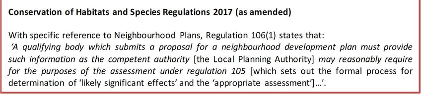
Box 1: The legislative basis for Appropriate Assessment
1.6 It is therefore important to note that this report has two purposes:
· To assist the Qualifying Body (the Neighbourhood Plan Group) in preparing their plan by
recommending (where necessary) any adjustments required to protect European sites, thus making it
more likely their plan will be deemed compliant with the Conservation of Habitats and Species
Regulations 2017 (as amended); and
· On behalf of the Qualifying Body, to assist the Local Planning Authority to discharge their duty under
Regulation 105 (in their role as ‘plan-making authority’ within the meaning of that regulation) and
Regulation 106 (in their role as ‘competent authority’).
1.7 As ‘competent authority’, the legal responsibility for ensuring that a decision of ‘likely significant effects’ is
made, for ensuring an ‘appropriate assessment’ (where required) is undertaken, and for ensuring Natural
England are consulted, falls on the local planning authority. However, they are entitled to request from the
Qualifying Body the necessary information on which to base their judgment and that is a key purpose of this
report.
1.8 Over the years, ‘Habitats Regulations Assessment’ (HRA) has come into wide currency to describe the
overall process set out in the Habitats Regulations, from screening through to identification of IROPI. This
has arisen in order to distinguish the overall process from the individual stage of "Appropriate Assessment".
Throughout this Report the term HRA is used for the overall process and restricts the use of Appropriate
Assessment to the specific stage of that name.
Prepared for: Elstead Parish Council AECOM
6Habitat Regulations Assessment: Elstead and Elstead Parish Council
Weyburn Neighbourhood Development Plan
2. Methodology
Introduction
2.1 The need for Appropriate Assessment is set out within Article 6 of the EC Habitats Directive 1992 and
interpreted into British law by the Conservation of Habitats and Species Regulations 2010. The ultimate aim
of the Directive is to “maintain or restore, at favourable conservation status, natural habitats and species of
wild fauna and flora of Community interest” (Habitats Directive, Article 2(2)). This aim relates to habitats and
species, not the European sites themselves, although the sites have a significant role in delivering
favourable conservation status.
2.2 The Habitats Directive applies the precautionary principle to European sites. Plans and projects can only
be permitted having ascertained that there will be no adverse effect on the integrity of the site(s) in
question. Plans and projects with predicted adverse impacts on European sites may still be permitted if
there are no alternatives to them and there are Imperative Reasons of Overriding Public Interest (IROPI)
as to why they should go ahead. In such cases, compensation would be necessary to ensure the overall
integrity of the site network.
2.3 Figure 1 below outlines the stages of HRA according to current Ministry of Housing, Communities and
Local Government guidance. The stages are essentially iterative, being revisited as necessary in response
to more detailed information, recommendations and any relevant changes to the Plan until no significant
adverse effects remain.
Evidence Gathering – collecting information on relevant European
sites, their conservation objectives and characteristics and other
plans or projects.
HRA Task 1: Screening for Likely Significant Effects
Identifying whether a plan is ‘likely to have a significant effect’ on a
European site
HRA Task 2: Appropriate Assessment
Ascertaining the effect on site integrity – assessing the effects of the
plan on the conservation objectives of any European sites ‘screened
in’ during HRA Task 1
HRA Task 3: Avoidance and Mitigation
Mitigation measures and alternative solutions – where adverse effects
are identified at HRA Task 2, the plan should be altered until adverse
effects are cancelled out fully
Figure 1: Four Stage Approach to Habitats Regulations Assessment. Source GOV.UK, 2019.
HRA Task 1 – Likely Significant Effects (LSE)
2.4 Following evidence gathering, the first stage of any Habitats Regulations Assessment is a Likely Significant
Effect (LSE) test - essentially a risk assessment to decide whether the full subsequent stage known as
Appropriate Assessment is required. The essential question is:
Prepared for: Elstead Parish Council AECOM
7Habitat Regulations Assessment: Elstead and Elstead Parish Council
Weyburn Neighbourhood Development Plan
”Is the project, either alone or in combination with other relevant projects and plans, likely to result in a
significant effect upon European sites?”
2.5 The objective is to ‘screen out’ those plans and projects that can, without any detailed appraisal, be said to
be unlikely to result in significant adverse effects upon European sites, usually because there is no
mechanism for an adverse interaction with European sites. This stage is undertaken in Chapter 4 of this
report.
HRA Task 2 – Appropriate Assessment (AA)
2.6 Where it is determined that a conclusion of ‘no likely significant effect’ cannot be drawn, the analysis has
proceeded to the next stage of HRA known as Appropriate Assessment. Case law has clarified that
‘appropriate assessment’ is not a technical term. In other words, there are no particular technical analyses,
or level of technical analysis, that are classified by law as belonging to appropriate assessment rather than
determination of likely significant effects.
2.7 During July 2019 the Ministry of Housing, Communities and Local Government published guidance for
Appropriate assessment1. Paragraph: 001 Reference ID: 65-001-20190722m explains: ‘Where the potential
for likely significant effects cannot be excluded, a competent authority must make an appropriate
assessment of the implications of the plan or project for that site, in view the site’s conservation objectives.
The competent authority may agree to the plan or project only after having ruled out adverse effects on the
integrity of the habitats site. Where an adverse effect on the site’s integrity cannot be ruled out, and where
there are no alternative solutions, the plan or project can only proceed if there are imperative reasons of
over-riding public interest and if the necessary compensatory measures can be secured’.
2.8 As this analysis follows on from the screening process, there is a clear implication that the analysis will be
more detailed than undertaken at the Screening stage and one of the key considerations during appropriate
assessment is whether there is available mitigation that would entirely address the potential effect. In
practice, the appropriate assessment would take any policies or allocations that could not be dismissed
following the high-level Screening analysis and analyse the potential for an effect in more detail, with a view
to concluding whether there would be an adverse effect on integrity (in other words, disruption of the
coherent structure and function of the European site(s)).
2.9 A decision by the European Court of Justice2 concluded that measures intended to avoid or reduce the
harmful effects of a proposed project on a European site may no longer be taken into account by competent
authorities at the Likely Significant Effects or ‘screening’ stage of HRA. That ruling has been considered in
producing this HRA.
2.10 Also, in 2018 the Holohan ruling3 was handed down by the European Court of Justice. Among other
provisions paragraph 39 of the ruling states that ‘As regards other habitat types or species, which are
present on the site, but for which that site has not been listed, and with respect to habitat types and species
located outside that site, … typical habitats or species must be included in the appropriate assessment, if
they are necessary to the conservation of the habitat types and species listed for the protected area’
[emphasis added]. This has been taken into account in the HRA process.
HRA Task 3 – Avoidance and Mitigation
2.11 Where necessary, measures are recommended for incorporation into the Plan in order to avoid or mitigate
adverse effects on European sites. There is considerable precedent concerning the level of detail that a
Local Plan document needs to contain regarding mitigation for recreational impacts on European sites. The
implication of this precedent is that it is not necessary for all measures that will be deployed to be fully
developed prior to adoption of the Plan, but the Plan must provide an adequate policy framework within
which these measures can be delivered.
1
https://www.gov.uk/guidance/appropriate-assessment#what-are-the-implications-of-the-people-over-wind-judgment-for-
habitats-regulations-assessments [Accessed: 07/01/2020].
2
People Over Wind and Sweetman v Coillte Teoranta (C-323/17)
3
Case C-461/17
Prepared for: Elstead Parish Council AECOM
8Habitat Regulations Assessment: Elstead and Elstead Parish Council
Weyburn Neighbourhood Development Plan
2.12 In evaluating significance, AECOM has relied on professional judgement as well as the results of previous
stakeholder consultation regarding development impacts on the European sites considered within this
assessment.
2.13 When discussing ‘mitigation’ for a Local Plan document, one is concerned primarily with the policy
framework to enable the delivery of such mitigation rather than the details of the mitigation measures
themselves since the Local Plan document is a high-level policy document.
Confirming Other Plans and Projects That May Act
‘In Combination’
2.14 It is a requirement of the Regulations that the impacts of any land use plan being assessed are not
considered in isolation but in combination with other plans and projects that may also be affecting the
European site(s) in question.
2.15 In considering the potential for regional housing development on European sites the primary consideration
is the impact of visitor numbers – i.e. recreational pressure and urbanisation.
2.16 When undertaking this part of the assessment it is essential to bear in mind the principal intention behind
the legislation i.e. to ensure that those projects or plans (which in themselves may have minor impacts) are
not simply dismissed on that basis but are evaluated for any cumulative contribution they may make to an
overall significant effect. In practice, in combination assessment is therefore of greatest relevance when the
plan would otherwise be screened out because its individual contribution is inconsequential.
2.17 Other plans that are likely to act in combination to Elstead NP are:
· Waverley Local Plan Part 1 – allocates (at least) 11,210 dwellings
· Guildford Local Plan: strategy and sites 2015-2034 – allocates (at least) 10,678 dwellings
· Witley Neighbourhood Plan 2017-2032 – allocates 300 dwellings
· Farnham Neighbourhood Plan 2017-2032 – allocates (some with planning permission) 2,201
dwellings
· Chiddingfold Neighbourhood Plan (March 2019) – allocates 130 dwellings
· Haslemere Neighbourhood Plan 2013-2032 – allocates (some already constructed) 990 dwellings
2.18 Waverley District Council are also producing a Local Plan Part 2 which will identify site allocations to deliver
the quantum of development set by Local Plan Part 1 and will cover parts of the district not already covered
by Neighbourhood Plans. However, LPP2 is still being drafted and cannot therefore be discussed in this
HRA.
Prepared for: Elstead Parish Council AECOM
9Habitat Regulations Assessment: Elstead and Elstead Parish Council
Weyburn Neighbourhood Development Plan
3. Internationally Designated Sites
Thursley, Hankley and Frensham Commons SPA
Introduction
3.1 The Thursley, Hankley and Frensham Commons (Wealden Heath Phase I) SPA forms a large complex of
lowland heaths (otherwise referred to as The Wealden Heaths) situated in Surrey close to the Hampshire
border. The complex is set in a largely rural setting with an unspoilt character despite its close proximity to
large population centres such as London and Guildford. The surrounding landscape includes oak
woodlands, conifer woods and small pastures intersected by narrow, sunken lanes. The underlying geology
of the commons is predominantly made up by sandstones and ironstone belonging to the group known as
Wealden Greensand of Cretaceous age. These form low hills and broad valleys, dissected by small streams.
The deposits give rise to mostly free-draining sandy soils, but layers of less permeable deposits give rise
locally to wetlands including mires, flushes and wet woodlands.
3.2 The complex is situated in the Surrey Hills Area of Outstanding Natural Beauty (AONB) and is in the
Wealden Greensand National Character Area (NCA). Several parts of the site are used for military training
and these areas have controlled public access. Part of the site is managed as a golf course. Most of the
remainder has open public access and some of the sites are very popular destinations for a range of
recreational activities including walking, birdwatching, horse riding, cycling and orienteering. Part of the site,
Thursley Common, is declared as a National Nature Reserve managed by Natural England4.
Reasons for designation
3.3 Qualifying individual species listed in Annex I of the Wild Birds Directive (Article 4.1) that are supported by
the site includes:
· Internationally important numbers of Dartford warbler Sylvia undata
· When classified, the SPA supported 20 pairs (which represented 4% of the British breeding
population in 1984).
§ The Thursley, Hankley and Frensham Commons SPA regularly supports internationally
important numbers of Dartford warbler. The SPA is close to the northern limit of the range of
this species in Europe and numbers fluctuate depending upon winter and spring weather
conditions. The species does not migrate and winter survival and breeding success can be
badly affected by very cold winters or prolonged periods of snow cover. Cold, damp spring
weather can also have damaging effects. Dartford warblers are strongly associated with
lowland heaths with extensive patches of mature gorse with an abundance of favoured
invertebrate prey items such as spiders. However, they will also nest in areas of mature
heather, clearings in forestry plantations and patches of bracken.
§ Dartford warblers are widely distributed across the SPA and the site provides extensive areas
of suitable habitat. Particularly large numbers of birds are regularly recorded at Hankley
Common and Frensham Common but they are widely distributed across the complex.
· Internationally important numbers of Nightjar Caprimulgus europaeus
§ When classified, the SPA supported 20 pairs (which represented 1% of the British breeding
population in 1984).
§ The Thursley, Hankley and Frensham Commons SPA regularly supports internationally important
numbers of nightjar. The European population of this species is thought to have undergone a
significant decline in the past as a result of loss of suitable habitat. However, data suggests that
there has been a trend of increasing numbers in recent years, which may be due to better
protection of core breeding areas and improved management of lowland heathland.
4
Natural England (2017). European Site Conservation Objectives: Supplementary Advice on Conserving and Restoring Site
Features. Available online from: http://publications.naturalengland.org.uk/publication/5735025425252352 [Accessed:
07/01/2020].
Prepared for: Elstead Parish Council AECOM
10Habitat Regulations Assessment: Elstead and Elstead Parish Council
Weyburn Neighbourhood Development Plan
§ Nightjars are nocturnal birds and can often be seen hawking for food at dusk and dawn. With
pointed wings and a long tails their shape is similar to a kestrel or cuckoo. Their cryptic, grey-
brown, mottled, streaked and barred plumage provides ideal camouflage in the daytime.
§ Nightjars are migratory, spending the winter months feeding in parts of Africa. The species is
considered to be vulnerable to the effects of long-term climate change on drought-prone areas of
Africa. Nightjar regularly utilise areas across the SPA for nesting and feeding. Favoured areas of
habitat are areas of heath with high structural diversity including bare patches or short vegetation,
but they will also utilise clearings in woods, broad rides in conifer plantations and sparsely
vegetated areas. Particularly large numbers of nightjar are regularly recorded in the SPA at
Thursley, Hankley, Frensham and Elstead Commons but they occur widely across the complex.
· Internationally important numbers of Woodlark Lullula arborea
· When classified, the SPA supported 27 pairs (which represented 12% of the British breeding
population in 1984).
§ Woodlark regularly utilise the Thursley, Hankley and Frensham Commons SPA in
internationally important numbers. This species suffered a serious population decline and
contraction in range in the UK up until the latter part of the 20th century. The population is
now recovering and colonising new areas as a result of protection and expansion of lowland
heaths. The woodlark has also benefited from rotational management of conifer plantations
where it can utilise recently felled areas and areas of young re-growth for nesting. Woodlarks
favour areas of short vegetation or sparsely-vegetated areas on heaths with scattered trees
for use as song-posts. They feed on seeds and small invertebrates. Numbers of woodlarks
tend to fluctuate over time in relation to successional development of heaths and plantations,
with large numbers often present following heath fires or tree clearance.
§ Woodlarks are regularly recorded across most of the SPA with particularly large numbers
often present at Thursley and Frensham Commons.
Current threats and pressures5
3.4 Thursley, Hankley and Frensham Commons SPA also forms part of an extensive complex of lowland
heathland, acid grassland, mire and commercial conifer plantations in south east England. The complex is
located close to urbanization and therefore a number of pressures and threats currently impact the site,
these include:
· Public access and disturbance;
· Undergrazing;
· Forestry and woodland management;
· Hydrological changes;
· Inappropriate scrub control;
· Invasive species;
· Wildlife/ arason;
· Air pollution;
· SAC feature’s location/ extent/ condition unknown;
· Military; and
· Habitat fragmentation.
5
Natural England (2014). Site improvement plan: Thames Basin. Available online at:
http://publications.naturalengland.org.uk/publication/6249258780983296 [Accessed: 07/01/2020].
Prepared for: Elstead Parish Council AECOM
11Habitat Regulations Assessment: Elstead and Elstead Parish Council
Weyburn Neighbourhood Development Plan
Conservation objectives6
3.5 ‘Ensure that the integrity of the site is maintained or restored as appropriate, and ensure that the site
contributes to achieving the aims of the Wild Birds Directive, by maintaining or restoring;
· The extent and distribution of the habitats of the qualifying features
· The structure and function of the habitats of the qualifying features
· The supporting processes on which the habitats of the qualifying features rely
· The population of each of the qualifying features, and,
· The distribution of the qualifying features within the site.’
Thursley, Ash, Pirbright and Chobham SAC
Introduction
3.6 Thursley, Ash, Pirbright and Chobham SAC is an extensive complex of heaths in the south east of England
with extensive areas of wet and dry heath, acid mire and bog pools. The complex is situated in the Surrey
Hills Area of Outstanding Natural Beauty (AONB) and is part of the Weald National Character Area. The
underlying geology of the site is composed of Lower Greensand age marine deposits laid down in the
Cretaceous period. This formation is made up of alternating sandstones and mudstones containing chert
and ironstone, and the formation includes the distinct layers of the Folkestone Beds, Sandgate Beds and
Bargate Beds.
3.7 The Folkestone Beds make up the high ground in parts of the complex. These are mostly relatively free-
draining sandstones but also include occasional 'lenses' of clay which impede drainage resulting in localised
surface wetness and seepages. The Folkestone Beds are a base-poor formation and so water percolating
through the beds generally remains nutrient and base-poor. The underlying Sandgate Beds are mostly made
up by finer-grained materials and have a higher clay content and so are generally less free-draining. It is
this impeded drainage which gives rise to the formation of the mire systems. A further aspect of the geology
is the influence of the Bargate Beds which are lower in the geological sequence. The Bargate Beds are
fossiliferous calcareous sandstones with a high content of calcium carbonate. Water percolating through
these deposits can develop a high base-status and this is thought to be the reason for a relatively high
alkalinity in the water feeding the west side of the mire system on Thursley Common. Surface peat is present
in the lower-lying waterlogged areas, which varies in thickness from 1-10cm over much of Ockley Common
to a maximum depth of about 1.5 metres on parts of Thursley Common. The site is set in a landscape of
extensive farmland, broadleaved woodland, pine woodland and small villages.
3.8 The complex includes outstanding examples of valley mire vegetation which supports very rich
assemblages of wetland invertebrates, bryophytes and scarce plants, and which provide a habitat for
breeding birds including curlew and snipe. Parts of the complex are managed as nature reserves with open
public access. Other parts have military training ranges and have limited or no public access7.
Reasons for designation
3.9 There are a number of qualifying habitats that are supported by the SAC, these include:
· Northern Atlantic wet heaths with Erica tetralix
§ This site represents lowland northern Atlantic wet heaths in south-east England. The wet heath at
Thursley is NVC type M16 Erica tetralix – Sphagnum compactum and contains several rare plants,
including great sundew Drosera anglica, bog hair-grass Deschampsia setacea, bog orchid
Hammarbya paludosa and brown beak-sedge Rhynchospora fusca. There are transitions to valley
bog and dry heath. Thursley Common is an important site for invertebrates, including the nationally
rare white-faced darter Leuccorhinia dubia.
6
Natural England (2019). European Site Conservation Objectives for Thursley, Hankley and Frensham Commons (Wealden
Heaths Phase 1) Special Protection Area. Available online at:
http://publications.naturalengland.org.uk/publication/5735025425252352 [Accessed: 07/01/2020].
7
Natural England (2016). European Site Conservation Objectives: Supplementary Advice on Conserving and Restoring Site
Features. Available online at: http://publications.naturalengland.org.uk/publication/5141075941392384 [Accessed: 07/01/2020].
Prepared for: Elstead Parish Council AECOM
12Habitat Regulations Assessment: Elstead and Elstead Parish Council
Weyburn Neighbourhood Development Plan
· European dry heaths
§ This south-east England site contains a series of large fragments of once-continuous heathland. It
is selected as a key representative of NVC type H2 Calluna vulgaris – Ulex minor dry heathland.
This heath type has a marked south-eastern and southern distribution. There are transitions to wet
heath and valley mire, scrub, woodland and acid grassland, including types rich in annual plants.
The European dry heaths support an important assemblage of animal species, including numerous
rare and local invertebrate species, European nightjar Caprimulgus europaeus, Dartford
warbler Sylvia undata, sand lizard Lacerta agilis and smooth snake Coronella austriaca.
· Depressions on peat substrates of the Rhynchosporion
§ This site contains examples of Depressions on peat substrates of the Rhynchosporion in south-
east England, where it occurs as part of a mosaic associated with valley bog and wet heath. The
vegetation is found in natural bog pools of patterned valley mire and in disturbed peat of trackways
and former peat-cuttings.
Current threats and pressures8
3.10 Thursley, Ash, Pirbright and Chobham SAC forms part of an extensive complex of lowland heathland, acid
grassland, mire and commercial conifer plantations in south east England. The complex is located close to
urbanization and therefore a number of pressures and threats currently impact the site, these include:
· Public access and disturbance;
· Undergrazing;
· Forestry and woodland management;
· Hydrological changes;
· Inappropriate scrub control;
· Invasive species;
· Wildlife/ arason;
· Air pollution;
· SAC feature’s location/ extent/ condition unknown;
· Military; and
· Habitat fragmentation.
Conservation objectives9
3.11 ‘Ensure that the integrity of the site is maintained or restored as appropriate, and ensure that the site
contributes to achieving the Favourable Conservation Status of its Qualifying Features, by maintaining or
restoring;
· The extent and distribution of qualifying natural habitats
· The structure and function (including typical species) of qualifying natural habitats, and
· The supporting processes on which qualifying natural habitats rely.’
Thursley and Ockley Bogs Ramsar
Introduction
3.12 Thursley and Ockley Bogs is a valley mire complex and lies within Thursley, Hankley & Frensham Commons
SSSI. The mire occurs within a matrix of heathland, where drainage is impeded, and a deep layer of peat
8
Natural England (2014). Site improvement plan: Thames Basin. Available online at:
http://publications.naturalengland.org.uk/publication/6249258780983296 [Accessed: 07/01/2020].
9
Natural England (2018). European Site Conservation Objectives for Thursley, Ash, Pirbright and Chobham Special Area of
Conservation. Available online at: http://publications.naturalengland.org.uk/publication/5141075941392384 [Accessed:
07/01/2020].
Prepared for: Elstead Parish Council AECOM
13Habitat Regulations Assessment: Elstead and Elstead Parish Council
Weyburn Neighbourhood Development Plan
has built up from the remains of bog-moss Sphagnum spp. which forms much of the vegetation. Several
areas of open water also contribute significantly to the overall diversity of the site, ranging from acidic boggy
pools and ditches to large ponds.
Reason for designation10
3.13 This site is designated under two Ramsar Criterion, these include:
· Ramsar Criterion 2- Supports a community of rare wetland invertebrate species including notable
numbers of breeding dragonflies
· Ramsar Criterion 3 - It is one of few sites in Britain to support all six native reptile species. The site
also supports nationally important breeding populations of European nightjar Caprimulgus europaeus
and woodlark Lullula arborea.
Current threats and pressures
· Appropriate management
· Managed recreational pressure
· Minimal air pollution
· Absence or control of urbanisation effects, such as fires and introduction of invasive non-native
species
· Maintenance of appropriate water levels
· Maintenance of water quality
Conservation objectives11
3.14 ‘Ensure that the integrity of the site is maintained or restored as appropriate, and ensure that the site
contributes to achieving the aims of the Wild Birds Directive, by maintaining or restoring;
· The extent and distribution of the habitats of the qualifying features
· The structure and function of the habitats of the qualifying features
· The supporting processes on which the habitats of the qualifying features rely
· The population of each of the qualifying features, and,
· The distribution of the qualifying features within the site.’
Wealden Heaths Phase 2 SPA
Introduction
3.15 The Wealden Heaths Phase II SPA is situated on an arc of hilly country on the edge of the Weald. The area
runs parallel to the South Downs and is located on the borders of Hampshire, Surrey and West Sussex.
3.16 The underlying geology is composed of Cretaceous sandstones and ironstone, which give rise to
predominantly acid soils. These are often sandy and free-draining but clay and silt layers produce poorly-
drained areas where streams and wetland habitats can be found. The landscape is largely rural and is
characterised by a prominent escarpment with broad, steep-sided valleys and low, rounded hills with a
mixture of heaths, oak and birch woodland, mature conifer woodlands, pastures and wetlands.
3.17 Large parts of the SPA are used for military training, including live-firing, and so public access is restricted.
However, there are also areas in the SPA which are very popular destinations for a variety of recreational
uses including walking, birdwatching, orienteering and cycling. Some of the land is registered common land
10
JNCC (2008) Information Sheet on Ramsar Wetlands (RIS). Available online at; http://archive.jncc.gov.uk/pdf/RIS/UK11074.pdf
[Accessed; 07/01/2020].
11
Natural England (2014). Site Improvement Plan Thames Basin. Available online at:
http://publications.naturalengland.org.uk/publication/5735025425252352 [Accessed: 07/01/2020].
Prepared for: Elstead Parish Council AECOM
14Habitat Regulations Assessment: Elstead and Elstead Parish Council
Weyburn Neighbourhood Development Plan
but traditional common land management practices, including grazing, have largely died out in the area.
Nevertheless, there are strong cultural and historical links to the past reflected in the landscape.
Reasons for Designation12
3.18 The SPA supports three Annex I species:
· Dartford warbler Sylvia undata - when classified, the SPA supported 16 pairs (5 year peak mean 1989-
1993) which represented 1.7% of the GB population.
· Nightjar Caprimulgus europaeus - when classified, the SPA supported 43 pairs (5 year peak mean
1989-1993) which represented 1.4% of the GB population.
· Woodlark Lullula arborea - when classified, the SPA supported 15 pairs (5 year peak mean 1989-1993)
which represented 4.3% of the GB population.
Current threats and pressures
3.19 The habitats and features that are supported by Wealden Heaths Phase 2 SPA are sensitive to changes in
air quality. Exceeding critical values for air pollutants may result in changes to the chemical status of a
supporting habitat’s substrate, accelerating or damaging plant growth, altering vegetation structure and
composition and thereby affecting the quality and availability of nesting, feeding or roosting habitats. Some
of the effects that might be attributable to aerial pollution could include accelerated and more vigorous
growth of bramble, birch and coarse grasses and consequent loss of bare ground and/or heather which
offer nest sites. In addition, to air quality pressures the site is also susceptible to disturbance caused by
recreational pressure. The nature, scale, timing and duration of some human activities can result in the
disturbance of birds at a level that may substantially affect their behaviour, and consequently affect the long-
term viability of the population.
Conservation objectives13
‘Ensure that the integrity of the site is maintained or restored as appropriate, and ensure that the site contributes
to achieving the aims of the Wild Birds Directive, by maintaining or restoring;
· The extent and distribution of the habitats of the qualifying features
· The structure and function of the habitats of the qualifying features
· The supporting processes on which the habitats of the qualifying features rely
· The population of each of the qualifying features, and,
· The distribution of the qualifying features within the site.’
Thames Basin Heaths SPA
Introduction
3.20 Thames Basin Heaths Special Protection Area (SPA) consists of a number of fragments of lowland
heathland scattered across Surrey, Hampshire and Berkshire. It is predominantly dry and wet heath but also
includes areas of deciduous woodland, gorse scrub, acid grassland and mire, as well as associated conifer
plantations. Around 75% of the SPA has open public access being either common land or designated as
open country under the Countryside and Rights of Way Act 2000. The SPA consists of 13 Sites of Special
Scientific Interest. Three of the SSSIs are also designated as part of the Thursley, Ash, Pirbright and
Chobham Special Area of Conservation (which is located more than 5km from Hart District boundary).
3.21 Bramshill SSSI and Hazeley Heath SSSI both lie within Hart District, along with the majority of Castle
Bottom to Yateley and Hawley Commons SSSI and the western part of Bourley and Long Valley SSSI.
12
Natural England (2019) Designated Sites View. Available online at:
https://designatedsites.naturalengland.org.uk/SiteGeneralDetail.aspx?SiteCode=UK9012132&SiteName=DEVIL, accessed
02/12/19
13
Natural England (2019). European Site Conservation Objectives for Wealden Heaths Phase II SPA. Available online at:
http://publications.naturalengland.org.uk/publication/5729030657540096, accessed 02/12/19.
Prepared for: Elstead Parish Council AECOM
15Habitat Regulations Assessment: Elstead and Elstead Parish Council
Weyburn Neighbourhood Development Plan
3.22 The location of the Thames Basin Heaths has resulted in the designated site being subject to high
development pressure. English Nature (now Natural England) published a Draft Delivery Plan for the
Thames Basin Heaths SPA in May 2006, partly in response to the European Court of Justice ruling of
October 2005. This is updated by the ‘Thames Basin Heaths Special Protection Delivery Framework’
published by the Thames Basin Heaths Joint Strategic Partnership Board in January 2009. These
documents aim to allow a strategic approach to accommodating development by providing a method
through which local authorities can meet the requirements of the Habitats Regulations through avoidance
and mitigation measures.
Reasons for designation14
3.23 Thames Basin Heaths SPA qualifies under Article 4.1 of the Birds Directive (79/409/EEC) by supporting
populations of European importance of the following species listed on Annex I of the Directive:
3.24 During the breeding season:
· Nightjar Caprimulgus europaeus
· Woodlark Lullula arborea
· Dartford Warbler Sylvia undata
Current treats and pressures15
3.25 The Thames Basin Heaths SPA are an extensive complex of lowland heathland, acid grassland, mire and
commercial conifer plantations in south east England. Features supported by this rare habitat are Dartford
warbler, woodlark, nightjar that are susceptible to disturbance generate by human activity. Current threats
and pressures that are experienced by the site are:
· Appropriate Management;
· Management of disturbance during the breeding season (March to July);
· Air pollution;
· Urbanisation;
· Maintenance of appropriate water levels; and
· Maintenance of water quality.
Ebernoe Common SAC
Introduction
3.26 Ebernoe Common is an extensive complex of ancient woodland and former wood pasture in West Sussex,
five miles south-east of Haslemere. The site lies on the Cretaceous Weald Clay and falls within the Low
Weald National Character Area (NCA 121). The central core of the site, approximately a third of the total
area, forms Ebernoe Common National Nature Reserve.
3.27 It is a varied site with a range of woodland communities and age structures which have developed due to
differences in underlying soils and past management. This range of conditions together with a long
continuity of woodland cover has in turn resulted in the site supporting an outstanding diversity of species:
Barbastelle and Bechstein's bats, which favour ancient woodland, breed in the site because it provides
suitable roosting and feeding habitats. While Bechstein's feed exclusively in the woodland, Barbastelles
commute into the surrounding countryside using the woodland corridors which branch out from the site. In
addition, the native trees, particularly those with old growth characteristics, support rich lichen and fungal
14
JNCC (2005). SPA Description: Thames Basin Heaths. Available online at: http://archive.jncc.gov.uk/default.aspx?page=2050,
accessed 02/12/19.
15
Natural England (2014). Site improvement plan: Thames Basin Heaths SPA. Available online at:
http://publications.naturalengland.org.uk/publication/6249258780983296, accessed 02/12/19.
Prepared for: Elstead Parish Council AECOM
16Habitat Regulations Assessment: Elstead and Elstead Parish Council
Weyburn Neighbourhood Development Plan
communities, including a number of rare and scarce species, and the woodland complex as a whole
supports a diverse breeding bird assemblage16.
Reason for designation17
3.28 Annex I habitats that are a primary reason for site selection include:
· Atlantic acidophilous beech forests with Ilex and sometimes also Taxus in the shrublayer (Quercion
robori-petraeae or Ilici-Fagenion); Beech forests on acid soils
§ This Annex I type comprises beech Fagus sylvatica forests with holly Ilex, growing on acid
soils, in a humid Atlantic climate. Sites of this habitat type often are, or were, managed as
wood-pasture systems, in which pollarding of beech and oak Quercus spp. was common.
This is known to prolong the life of these trees.
3.29 Annex II species that are supported by the site that are primary reason for site selection include:
· Barbastelle Barbastella barbastellus
§ The barbastelle is a medium-sized bat unlike any other in Europe. The fur is almost black,
usually with very pale or golden-brown tips to the hairs. The ears are very broad with the inner
edges joined together across the forehead.
§ Barbastelle ecology is relatively poorly-known. In Europe it is believed to be mainly an upland
and forest species; in the UK it seems to prefer wooded river valleys. The species forages in
mixed habitats, usually over water. Barbastelles appear to select cracks and crevices in wood
for breeding, mostly in old or damaged trees, but cracks and crevices in the timbers of old
buildings may also be used. Maternity colonies may move between suitable crevices within a
small area, such as a piece of woodland or a complex of buildings. Caves and underground
structures may be used for hibernation. The species is very sensitive to disturbance, together
with the loss of roost-sites and food resources.
§ The barbastelle is one of the UK’s rarest mammals. Few maternity roost sites are known in
the UK. The great majority of other records come from caves or abandoned mines, which are
important hibernation sites for a range of bat species. The barbastelle is widely distributed
across southern England and across Wales but is likely to have been significantly under-
recorded within its range. Individual bats are sometimes discovered in buildings during
summer.
· Bechstein’s bat Myotis bechsteinii
§ Bechstein’s bat is a medium-sized species, with very long ears and a long, pointed, bare, pink
face. It has shaggy light-to reddish-brown fur on its back and contrasting greyish white-tipped
fur on its underside. The species is closely associated with mature deciduous woodland and
appears to select old woodpecker holes or rot holes in trees for breeding. It also occurs in
coniferous woodland in some areas.
§ Maternity colonies may move between suitable crevices within a small area, such as a piece
of woodland. It is believed to hibernate in hollow trees and sometimes in underground
localities. It is one of the UK’s rarest mammals, recorded from only a small number of sites in
southern England and Wales. Very few maternity roosts are currently known, one of which is
in a bat-box. The great majority of other records come from caves or abandoned mines, which
are important hibernation sites for a range of bat species.
§ It is also one of the rarest bats in western Europe and is regarded as endangered in several
countries. A population decrease has been reported over most of its European range. The
species occurs from the Iberian Peninsula east to the Ukraine and Moldova. Local populations
in southern England, Wales, southern Sweden and Bornholm mark the northern border of the
range. A maternity colony of Bechstein’s bat is associated with the site. Roosts are mainly in
old woodpecker holes in the stems of live mature oak Quercus petraea trees.
16
Natural England (2019). European Site Conservation Objectives: Supplementary advice on conserving and restoring site
features. Available online from: http://publications.naturalengland.org.uk/publication/6255629165395968 [Accessed: 20/11/19].
17
JNCC (2019). Ebernoe Common SAC. Available online at: https://sac.jncc.gov.uk/site/UK0012715 [Accessed: 20/11/2019]
Prepared for: Elstead Parish Council AECOM
17Habitat Regulations Assessment: Elstead and Elstead Parish Council
Weyburn Neighbourhood Development Plan
Current threats and pressures18
3.30 Ebernoe Common is an extensive block of mature woodland and former wood pasture which has been
under continuous woodland cover for at least the last 500 years. The range of woodland types within the
site and their longstanding history allows it to support an outstanding diversity of species. In particular,
Barbastelle and Bechstein's bats - who favour ancient woodland - breed in the site because it provides
suitable roosting and feeding habitats. While Bechstein's feed exclusively in the woodland, Barbastelles
commute into the surrounding countryside using the woodland corridors which branch out from the site.
Therefore, current threats and pressures occur from direct pressure the SAC and those outside the SAC.
The include:
· Forestry and woodland management;
· Offsite habitat availability/ management;
· Habitat fragmentation;
· Change in land management;
· Hydrological changes;
· Air pollution; and
· Public access/ disturbance.
Conservation objectives19
3.31 ‘Ensure that the integrity of the site is maintained or restored as appropriate, and ensure that the site
contributes to achieving the Favourable Conservation Status of its Qualifying Features, by maintaining or
restoring;
· The extent and distribution of qualifying natural habitats and habitats of qualifying species
· The structure and function (including typical species) of qualifying natural habitats
· The structure and function of the habitats of qualifying species
· The supporting processes on which qualifying natural habitats and the habitats of qualifying species rely
· The populations of qualifying species, and,
· The distribution of qualifying species within the site.’
The Mens SAC
Introduction
3.32 The Mens is one of the largest ancient woodlands in West Sussex and supports a significant population of
barbastelle Barbastella barbastellus. It is eight miles south-west of Horsham and falls within the Low Weald
National Character Area (NCA 121). Most of the woodland lies on Weald Clay although in some places
Paludina limestone outcrops at the surface. It is a varied site with a range of woodland communities and
age structures which have developed due to differences in underlying soils and past management. The site
also supports outstanding invertebrate, fungi, lichen and bryophyte assemblages.
3.33 The woodland is predominantly high forest of sessile oak Quercus petraea and pedunculate oak Quercus
robur, beech Fagus sylvatica, holly Ilex aquifolium and locally, ash Fraxinus excelsior, birches Betula spp.
and wild service tree Sorbus torminalis. Beech dominates the lighter soils over an understorey of holly and
yew Taxus baccata. On the heavier clay soils oak-ash woodland occurs over a mixed shrub layer which
includes hazel Corylus avellana, hawthorn Crataegus monogyna, crab apple Malus sylvestris and
blackthorn Prunus spinosa. It is developing a near-natural high forest structure, in response to only limited
silvicultural intervention over the 20th century, combined with the effects of natural events such as the 1987
18
Natural England (2015). Site improvement plan Ebernoe Common. Available online at;
http://publications.naturalengland.org.uk/publication/6364242571689984 [Accessed: 20/11/19].
19
Natural England (2018). European Site Conservation Objectives for Ebernoe Common Special Area of Conservation.
http://publications.naturalengland.org.uk/publication/6255629165395968 [Accessed: 20/11/19].
Prepared for: Elstead Parish Council AECOM
18You can also read