Estuary Management Plan 2020-2030 - Avon Heathcote Estuary ...
←
→
Page content transcription
If your browser does not render page correctly, please read the page content below
Estuary Management Plan
                                   2020-2030

Estuary of the Heathcote and Avon Rivers/Ihutai, Ōtautahi/Christchurch, Aotearoa New Zealand.
Photo by Paul Corliss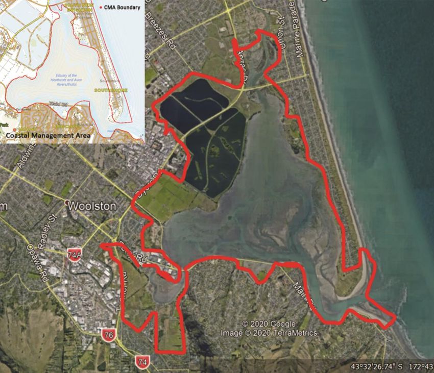
2020 Estuary Management Plan

                               1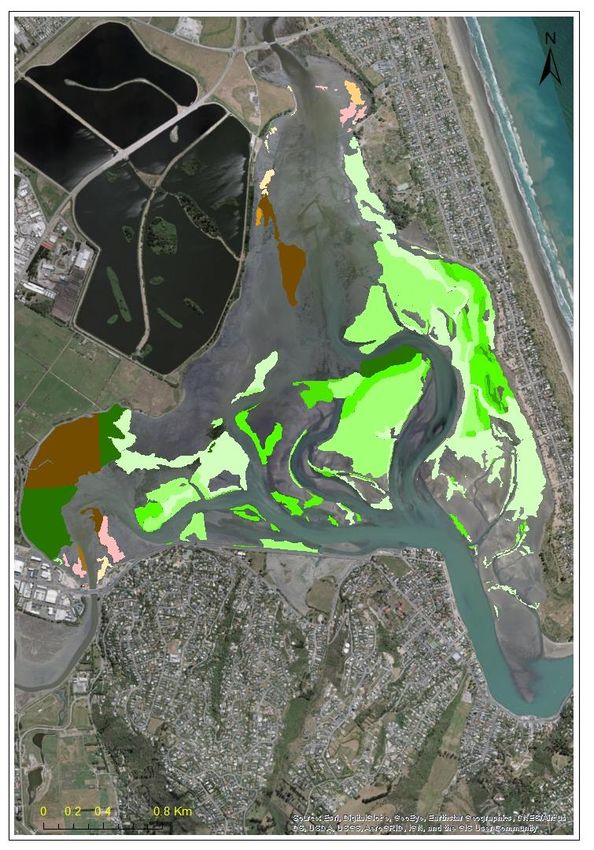
2020 Estuary Management Plan

                                    Estuary
                          Management Plan

 The Avon-Heathcote Estuary and lower reaches of the
           Ōtākaro (Avon) and Ōpāwaho
                               (Heathcote) Rivers

                                   2020-2030

Prepared by the Avon-Heathcote Estuary Ihutai Trust (Estuary Trust)

                                    August 2020

                                 www.estuary.org.nz

                         contact: info@estuary.org.nz

                               ISBN: 978-0-473-55693-8

                                          2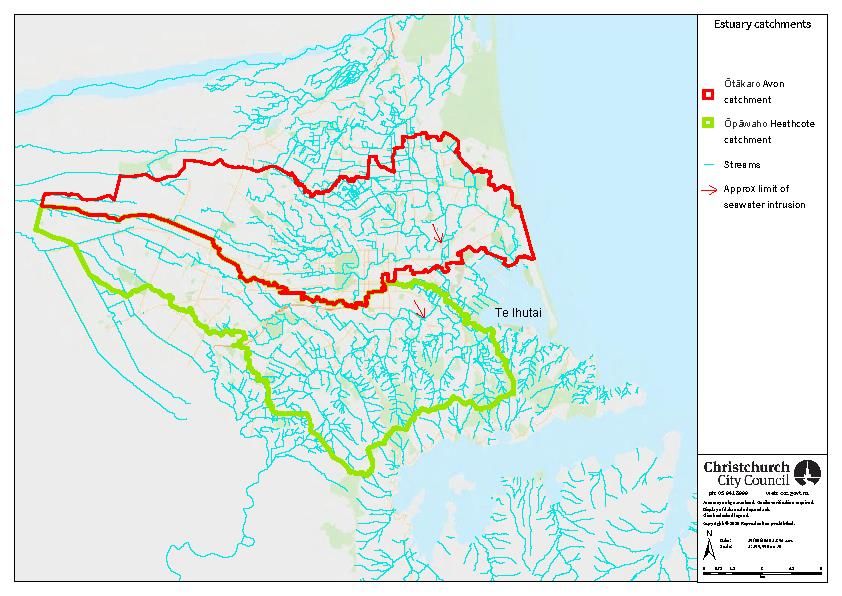
2020 Estuary Management Plan

      The vision of the Avon-Heathcote Estuary Ihutai Trust is to

  Restore the mauri; the cultural and ecological health of Te Ihutai

                               Toitū te taonga ā iwi

                               Toitū te taonga ā Tāne

                          Toitū te taonga ā Tangaroa

                                    Toitū te iwi

                     Communities working together for:

                                    Clean water

                                Healthy ecosystems

                                    Open space

                                And safe recreation

                                         3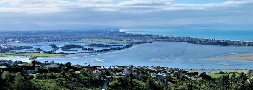
2020 Estuary Management Plan

Contents
1     CONTEXT ................................................................................................................... 6
    1.1       Introduction ............................................................................................................................ 6
    1.2       A shift in priorities ................................................................................................................... 7
    1.3       Area covered by the Plan ........................................................................................................ 7

2     HISTORY .................................................................................................................... 9
    2.1       Place ........................................................................................................................................ 9
    2.2       People ..................................................................................................................................... 9
    2.3       Cultural health ...................................................................................................................... 11

3     COMMUNITIES WORKING TOGETHER ...................................................................... 11
    3.1       Clean water ........................................................................................................................... 12
      3.1.1         Reduced water quality ................................................................................................... 12
      3.1.2         Flood, stormwater and groundwater management systems ........................................ 12
      3.1.3         Nutrient levels................................................................................................................ 13
      3.1.4         Sediment contaminant levels ........................................................................................ 15
    3.2       Healthy ecosystems .............................................................................................................. 16
      3.2.1         Biodiversity .................................................................................................................... 16
      3.2.2         Pest species .................................................................................................................... 19
      3.2.3         Loss of kaitiakitanga ....................................................................................................... 19
      3.2.4         Development of the estuary edge ................................................................................. 20
    3.3       Open space............................................................................................................................ 20
      3.3.1         Access and degradation of the estuary margins ............................................................ 20
      3.3.2         Public access .................................................................................................................. 20
    3.4       Safe recreation ...................................................................................................................... 21

4     CLIMATE CHANGE .................................................................................................... 22
    4.1       Sea level rise and acidification .............................................................................................. 22
    4.2       Tidal compartment and mouth dynamics............................................................................. 23
    4.3       Drought ................................................................................................................................. 23
    4.4       Sedimentation ....................................................................................................................... 24

5     PROTECTION MECHANISMS ..................................................................................... 24
    5.1       Mātaitai reserve status ......................................................................................................... 24
    5.2       Ramsar status........................................................................................................................ 24

                                                                             4
2020 Estuary Management Plan

6      KEY MANAGEMENT GOALS, OBJECTIVES AND ACTIONS ............................................ 25
    GOAL 1: Communities Working Together for Better Management of the Estuary .......................... 26
    GOAL 2: Promote Clean Water ......................................................................................................... 28
    GOAL 3: Support Healthy Ecosystems for the Estuary and its Surrounds ........................................ 29
    GOAL 4: Management of Open Space ............................................................................................. 31
    GOAL 5: Safe Recreation ................................................................................................................... 32

7      ACKNOWLEDGEMENTS ............................................................................................ 33

8      REFERENCES ............................................................................................................ 33

9      GLOSSARY ............................................................................................................... 35

FIGURES

       Figure 1: Map of the estuary showing area covered by the Plan. Courtesy of CCC........................ 8
       Figure 2: Te Ihutai/Avon-Heathcote Estuary catchment. Sourced from CCC ................................. 9
       Figure 3: Distribution of macroalgae through the estuary (Bolton-Ritchie 2020, Figure 3-4).
       Courtesy of Lesley Bolton-Ritchie, ECan ....................................................................................... 14
       Figure 4: Map of vegetation in the estuary. Courtesy of Ecan...................................................... 18

                                                                        5
2020 Estuary Management Plan

1       CONTEXT
1.1 Introduction
Te Ihutai/Avon Heathcote Estuary, with its tributaries the Ōtākaro/Avon and Ōpāwaho/Heathcote Rivers,
is a taonga (treasure) for Te Rūnanga o Ngāi Tahu, the principal iwi in Te Wai Pounamu/the South Island of
Aotearoa New Zealand, and the people of Ōtautahi (Christchurch). Te Ihutai and its catchment are of
significant cultural and spiritual importance, having been a place of settlement and mahinga kai for
Waitaha, Ngāti Māmoe and Ngāi Tahu since about 1290AD. Today the estuary and its catchment continue
to be held in high regard for their ecological values, landscape, and recreational values.

The purpose of this Estuary Management Plan (the Plan) is to work toward restoring the mauri (life force)
of Te Ihutai, to restore the estuary to full ecological and cultural health so that once again it can provide
mahinga kai: the natural resources that sustain life, including people. Mahinga kai is about both the place
and the ability to gather resources there. It is essential to sustain mana and kaitiakitanga, or what today
we call guardianship. Such practices remain a foundation of Ngāi Tahu values but have become
increasingly difficult as species and habitats are compromised, degraded, or lost.

Protecting and enhancing key features, and investigating and eliminating sources of contaminants, are
important challenges for managing and improving the estuary. Ongoing monitoring and cultural
assessments are vital to understand the success of actions. A strategic and coordinated management
approach across all levels of government, Ngāi Tahu, industry and the community remains our best
prospect for a future clean and healthy estuary. The Plan sets the context, identifies goals and prioritises
actions to achieve these goals.

The Plan is a community document, the success of which depends on the goodwill, participation, and
commitment of those identified as responsible for carrying out the actions. It addresses the current issues
and concerns of the Avon-Heathcote Estuary Ihutai Trust (Estuary Trust). The Plan is also a living
document and will be updated as necessary. The Estuary Trust’s website www.estuary.org.nz holds the
current Plan.

A series of events triggered a review of the ecological and cultural decline of Te Ihutai. The upgrade of
Christchurch City’s sewerage system came with the promise of improved water quality. Officially the
upgrade opened in March 2010 when the wastewater from the Bromley Sewage Treatment Plant began
discharging three kilometres out into Pegasus Bay via an ocean outfall. Then, the Canterbury Earthquake
Sequence (CES) 2010-2012 caused significant uplift of areas of the estuary, disrupting the ecological
system of the mudflats and damaging sewerage and roading infrastructure. More recently the 2019-2020
drought and the Covid-19 pandemic of 2020 have prompted a rethink of the values placed on nature.
Now with wastewater and stormwater infrastructure largely repaired and the potential for innovative land
uses adjacent to Te Ihutai, new opportunities have emerged to improve the estuary’s ecological and
cultural health.

The Estuary Trust shares this aspiration with its partners Te Ngāi Tūāhuriri Rūnanga and Te Ihutai Ahu
Whenua Trust (Ihutai Trust), who hold mana whenua (authority over the area, or customary land and
water rights) over Te Ihutai (Te Runanga o Ngai Tahu Act 1996 [2001]). Te Hapū o Ngāti Wheke of Te
Rāpaki o Te Rakiwhakaputa also have an historical connection with Te Ihutai. Together with mana whenua

                                                      6
2020 Estuary Management Plan
the Estuary Trust's partners Environment Canterbury and the Christchurch City Council support this Plan.
The Estuary Trust considers that restoring Te Ihutai to health to the extent that it is safe to gather mahinga
kai will have wide-ranging benefits. The Trust hopes that this Plan will guide future developments in
Ōtautahi and looks forward to working with mana whenua, Environment Canterbury and Christchurch
City Council to restore the mauri, the ecological and cultural health of Te Ihutai.
1.2 A shift in priorities
The Plan’s Schedule for Action (Section 6) reflects a global shift towards ecological planning and
management that is less anthropocentric, a shift necessitated by long-term ecological challenges such as
the climate and ecological crisis. The Plan strengthens earlier advice to the Estuary Trust, in 2017, that
ecological values should be prioritised “when planning recreational activities and public access to the
Estuary” (Wildlands Report 2017). New research on bird disturbance in 2019 and 2020 has continued to
buttress the evidence base for the advice to prioritise ecological values (Kaldor 2019, Figueiredo 2020).
Only by reordering its priorities to favour nature will the Estuary Trust achieve the goal of restoring the
mauri of Te Ihutai.
Guided by this purpose, the Plan proposes a greater commitment to waterway management, ecological
restoration, research and monitoring to improve the cultural and ecological health of Te Ihutai.
1.3 Area covered by the Plan
The area covered by the Plan includes Christchurch City Council reserves surrounding the estuary and the
Te Huingi Manu Wildlife Refuge that encompasses the Bromley oxidation ponds and the adjacent estuary
edge. The area includes all parts of the estuary permanently covered in water; habitats that range from
mudflats, sand, seagrass and shellfish beds to restored and constructed saltmarshes, to freshwater
treatment ponds, grasslands and paddocks, scrub, and regenerating forest.
The Estuary Trust’s previous plan (the 2013 Ihutai Management Plan) covered the Coastal Marine Area
and lands immediately surrounding the margins of the estuary. This included the area of the estuary
mouth to approximately 300 metres upstream of the Ōtākaro/Avon and Ōpāwaho/Heathcote rivers, and
the wastewater treatment ponds. The area covered by this 2020 Plan extends upstream beyond those
previous limits to secure improvements in upstream water quality for ecological restoration in these
catchments. (See Figure 1 and Figure 2.) Figure 1 is based on the area identified as the Avon-Heathcote
Estuary coastal wetland system for purposes of habitat and wildlife management.
72020 Estuary Management Plan
Figure 1: Map of the estuary showing area covered by the Plan. Courtesy of CCC
82020 Estuary Management Plan
Figure 2: Te Ihutai/Avon-Heathcote Estuary catchment. Sourced from CCC
2 HISTORY
2.1 Place
Te Ihutai is an 880 hectare, geologically young coastal feature, located approximately 12 kilometres east
of Christchurch's city centre. Around 1500 years ago a ready supply of offshore sand from the
continental shelf and the longshore drift of sediments from the Waimakariri and Ashley Rivers built up to
the landward edge of the current estuary (McFadgen & Goff 2005). The spit developed from sediment
that moved southward from the Waimakariri River, closing off what was a small embayment and now
forming what we call Te Ihutai, the Avon-Heathcote Estuary. It is now a water body sheltered from open
ocean swells, receiving freshwater from the Ōtākaro/Avon River and Ōpāwaho/Heathcote River that
mixes with seawater from the incoming tides.
The estuary and Southshore Spit continue to be dynamic systems. Aerial photography shows that the
south end of the spit has been mobile over the last century. Up to 20 houses along the open-coast and
estuary shores of the spit tip now occupy areas that were foreshore in the 1940s.
2.2 People
The history of Te Ihutai, beginning with the country’s late settlement by humans, offers insights that may
assist the estuary’s ecological and cultural recovery. Waitaha were the first people and tīpuna (ancestors)
92020 Estuary Management Plan
to settle in two main kāinga around Te Ihutai; first in a substantial village at Te Raekura/Redcliffs around
1290AD and later at Te Ka-a-Te Karoro/South New Brighton. Then in the 1500s, Ngāti Māmoe settled on
Tauhinukorokio/Mt Pleasant and in the 1600s, Te Rūnanga o Ngāi Tahu established a pā from which they
moved from site to site. Te Ihutai was renowned for its abundant fish and shellfish, including tuna (eels),
inanga/inaka (whitebait), pātiki (flounder), tuangi/tuaki (cockles) and pipi. (See Ngāi Tahu Atlas,
www.kahurumanu.co.nz/atlas.) The catchment – outlined in Figure 2 – contained springs, waterways,
wetlands, and swamps. Equally important to mana whenua was – and still is – the connection of the
estuary to the land and the mountains according to the principle Ki uta ki tai, from the mountains to the
sea.
With European settlement of Canterbury from 1850, Te Ihutai became a transport route for small ships
via the Ōpāwaho/Heathcote and Ōtākaro/Avon to central Christchurch. But river travel and trade rapidly
ceased because settler activities, especially vegetation clearance across the catchment, caused the river
channels to silt up. The Lyttelton rail tunnel’s completion in the 1860s also made the seaport accessible in
Lyttelton. By the 1890s polluting industries such as tanneries along the banks of the Ōpāwaho/Heathcote
contaminated both the river and estuary.
From the late 1860s the growing city established a 900-acre nightsoil reserve in the sandhills in Bromley
followed by a neighbouring irrigation reserve, where in the 1880s the Christchurch Drainage Board set up
a sewage farm beside Te Ihutai with settling ponds for the city’s effluent (Sketch map Christchurch
Drainage District 1882, Owen ed. 1992, Mein Smith 2020).
In parallel, in 1868 the Native Land Court set aside a 10-acre coastal reserve on the estuary’s northwest
edge on behalf of Kaiapoi Rūnanga landowners. This was in partial recompense for earlier unjust dealings
that were contrary to law and the Treaty of Waitangi (Evison 1997). A fishing easement, Te Ihutai Māori
Reserve (MR 900) recognised and preserved fishing rights by providing access to the estuary fishery. The
creation of the reserve reflected the colonial government’s failure to keep the promises sought by Ngāi
Tahu to exclude the land from sale and to maintain access to mahinga kai needed to give them a stake in
the developing economy. By 1900 few iwi members remained in Ōtautahi due to the poor environmental
conditions. Most moved north of the Waimakariri River to Tuahiwi, while others resided on reserves at
Wairewa (Little River), Ōnuku (Akaroa), Rāpaki, and Koukourārata (Port Levy). Even so, Te Ihutai
remained a site of cultural significance (Lobb 2009).
As Christchurch grew, unmanaged development continued along both urban rivers and combined with
the dumping of waste beside the estuary led to environmental decline, eroding the ecological and
cultural health of the estuary and its catchment. In 1956, a century after Christchurch was founded, the
Drainage Board confiscated MR 900 under the Public Works Act to build the Bromley oxidation ponds for
a new sewerage scheme that discharged treated wastewater directly into the estuary. Although the
sewerage upgrade brought health benefits to residents, the continued use of the estuary for the city’s
waste perpetuated the history of disregard for mana whenua and for the estuary.
Te Ihutai Ahu Whenua Trust (Ihutai Trust), established under a 1993 Act, represents the descendants of
the original owners of Te Ihutai Māori Reserve (MR 900). (See https://maorilandcourt.govt.nz.) The
Estuary Trust acknowledges the hurt that the 1956 confiscation inflicted on the original grantees and
their descendants – today’s beneficial owners to whom the Ihutai Trust reports – when mana whenua
102020 Estuary Management Plan
past and present had already suffered dispossession from colonisation. The Estuary Trust also
acknowledges the offence caused by the historical mistreatment of Te Ihutai and its catchment.
The Estuary Trust was constituted in 2002 out of public concern about the state of the estuary, and the
city’s wastewater treatment gradually improved. By 2008 it was no longer publicly acceptable to
discharge treated wastewater into Te Ihutai. In 2010, the Christchurch City Council completed the ocean
outfall to pump treated sewage three kilometres offshore. But the promised improvements in water
quality were disrupted by the CES 2010-2012. Damaged stormwater and wastewater infrastructure
meant that pollution again entered estuary habitats.
By 2020, water quality had improved markedly with the ocean pipeline transporting treated wastewater
to the ocean and repairs to stormwater infrastructure largely completed. Further, the Global Settlement
Agreement signed by the Crown and Christchurch City Council in September 2019 opened the way for
ecological restoration projects within the residential red zone. This provided a unique opportunity for the
Estuary Trust to act: a-once-in-a-generation chance to restore the estuary’s ecological and cultural health.
2.3 Cultural health
Many issues relating to the loss of mahinga kai in Canterbury remain unresolved. The State of the Takiwā
survey of 30 sites (Pauling et al. 2007) concluded that most sites in the estuary and its catchment were in
poor to very poor ecological health. Repeat surveys by Lang et al. (2012) following the CES 2010-2012
produced similar results. Of five estuary sites, two at Te Raekura/Redcliffs and Rapanui/Shag Rock had
improved in health by 2012, one showed no change and two had declined. Three estuary sites scored as
poor and one (the estuary outfall) very poor in health, with only Rapanui/Shag Rock rated moderate. All
sites were assessed as unsuitable for gathering mahinga kai. Except for the sites at Te Raekura/Redcliffs
(NIWA 2020), this remains the case today.
Where improvements were recorded between 2007 and 2012, these were due to riparian restoration
efforts in the catchment (Lang et al. 2012). The management responses required to protect and enhance
Ngāi Tahu values include improvements to water quality, especially through improving stormwater quality
and sediment control; improvements to habitat values through the restoration and conservation of
indigenous saltmarsh and saltmeadow, as well as mudflats; non-disturbance of wetland habitats and
migratory birds; and restoration to health of fish and shellfish stocks.
3 COMMUNITIES WORKING TOGETHER
Communities working together is the fundamental philosophy of the Estuary Trust and will help to ensure
the integrated management of the issues that affect Te Ihutai. The Estuary Trust is also committed to
working closely with relevant parties to ensure effective integrated management and to address four
main community concerns that were identified in the 2013 Ihutai Management Plan: 1
• clean water
• healthy ecosystems
• open space, and
• safe recreation
1
In 2020 the Estuary Trust renamed its management plan the Estuary Management Plan to avoid confusion
with the Ihutai Trust, ie Te Ihutai Ahu Whenua Trust.
112020 Estuary Management Plan
The Estuary Trust respects the relationships of Ngāi Tūāhuriri and the Ihutai Trust with Te Ihutai and
hopes that its partnership with mana whenua will encourage participation and support for restoration
projects and other undertakings.
Community engagement with the local community and residents across Christchurch is important to
improve the public perception of Te Ihutai, to help it be recognised as a significant ecological and cultural
feature, and to develop the sense of connection that will prompt people to participate in restoration
projects or simply to enjoy its natural values. Local catchment groups such as the Avon-Ōtākaro Network
also play an important role in the management of the wider catchment area.
The management of the estuary is the responsibility of both the Christchurch City Council and
Environment Canterbury under the Resource Management Act. City responsibilities are largely focused
on the land margins outside the Coastal Marine Area while Environment Canterbury is responsible for the
control of activities on the estuary, discharges, extraction of sand, shingle and other natural materials,
and hazard mitigation. Both councils work together through the Christchurch West Melton water zone
committee to improve water quality. In 2004, both councils became signatories to a ten-year
Memorandum of Understanding to support the Estuary Trust to achieve its goals under the 2004 and
2013 Ihutai Management Plans. The MOU was revised and re-signed by the three parties in 2016.
Education and research organisations, from schools through to the universities and other research
organisations, are central in helping the Estuary Trust make informed management decisions. Scientific
and social studies of the estuary will continue to provide valuable data and information as part of estuary
management.
There are several recreational groups based around the estuary whose members undertake activities on
the water or nearby, including yacht clubs, wind and kite surfing groups.
The Estuary Trust will continue to develop relationships and work with local industry and businesses at
Ferrymead, along the Ōpāwaho/Heathcote River and at Redcliffs to provide resources and help improve
local community engagement in the area covered by the Plan.
3.1 Clean water
3.1.1 Reduced water quality
For 20 years, Environment Canterbury and Christchurch City Council have regularly measured the water
quality of the rivers and estuary. Water quality is a significant factor affecting biodiversity, health and the
survival of organisms. The removal of treated wastewater from the estuary in 2010 resulted in immediate
improvements in water quality and reduced nutrients and fine sediments. But water quality declined
rapidly soon afterwards, following the earthquake of 22 February 2011. Since 2013 there has been some
improvement, although there are still regular fluctuations for some environmental parameters. The
quantities of fine sediment in the water remain relatively high in the Ōpāwaho/Heathcote River near the
Ferrymead Bridge (Bolton-Ritchie 2019). While trends in different measures of water quality were
variable from 2014 to 2019, turbidity (water clarity) improved (NIWA 2020).
3.1.2 Flood, stormwater and groundwater management systems
Because large parts of Christchurch City were built on drained wetlands, especially in the lower reaches
of the Ōtākaro/Avon and Ōpāwaho/Heathcote Rivers, floods, storms, and tidal inundation have always
posed a threat. To reduce risks of flooding, large stormwater ponds with a focus on green infrastructure
are being built in the upper Ōpāwaho/Heathcote catchment. These will also reduce the volume of
sediment entering the waterways. Similar opportunities are available for the Ōtākaro/Avon using the
122020 Estuary Management Plan
Ōtākaro residential red zone land. Regulations also now minimise inputs from riverside industries.
Consequently, the quality of water entering Te Ihutai from the catchment should improve. Groundwater
inputs will still pose an ongoing issue, however, and will need to be carefully monitored.
3.1.3 Nutrient levels
Te Ihutai, like many estuaries worldwide, has received excessive nutrients from high macroalgal
production resulting in eutrophication. The low oxygen levels and macroalgal blooms have degraded the
marine environment. The main nutrients measured in the annual Environment Canterbury Healthy
Estuary and Rivers of the City monitoring programme and Christchurch City Council Rivers Water
monitoring programme (monthly sampling from 2007 to present) show inputs of nitrogen (nitrates and
ammonia) and phosphorus (dissolved phosphorus). Estuary nitrate and dissolved phosphorus levels are
generally site specific. Total nitrogen levels trended down over the period 2014-2019 but levels of
ammonia trended upwards at the Beachville Rd site (NIWA 2020). Nitrogen, for example from the rivers,
therefore does not explain the recent increased algae blooms. Addressing levels of nitrates in rivers will
not improve the water quality of the estuary because there are different trigger values for the estuary
than for the rivers. Levels of ammonia improved markedly in recent years, remaining well below the
trigger values that are expected to affect 95 per cent of species.
At Sandy Point on the northwest edge of the estuary west of the oxidation ponds, the monitoring site has
demonstrated consistently poor water quality (Bolton-Ritchie 2017, 2019, 2020). Regular monitoring
shows that nutrient concentrations are higher than expected at Sandy Point, but the source of seepage is
unknown. The Estuary Trust would like to see water quality monitoring is carried out on drains near the
oxidation ponds along with flow analyses of the Linwood Canal.
In summary, the closer to the ocean the better the water quality of the estuary (NIWA 2020).
Ongoing monitoring by regional and local authorities and investigations by professional research bodies
such as NIWA2 are essential to identify significant changes in estuary health. The report of June 2020
prepared by NIWA for Environment Canterbury on Water quality of Estuary of the Heathcote and Avon
Rivers/Ihutai, for example, demonstrates the value of long-term, systematic monitoring. The Estuary
Trust endorses the recommendations from the 2020 NIWA report (section 7.7):
• Retain existing water quality sampling site locations to maintain the high value of time series
• Collect and analyse data from drains near the wastewater treatment ponds, as well as
continue current monitoring of rivers and coastal waters
• Regular monitoring of intertidal macroalgal populations as a key indicator of biological
response to climate and nutrient conditions in the estuary
• Improve detection of trends in metals and bacteria through methods with lower detection
limits
• Add visual clarity measurements to monitoring at estuary sites
To restore the mauri of Te Ihutai, Environment Canterbury and the Christchurch City Council need to
maintain the focus on improving water quality.
2
National Institute of Water and Atmosphere.
132020 Estuary Management Plan
Key: Percent cover of the
different macroalgae
Figure 3: Distribution of macroalgae through the estuary (Bolton-Ritchie 2020, Figure 3-4).
Courtesy of Lesley Bolton-Ritchie, ECan
142020 Estuary Management Plan
One of the main effects of increased nutrients in estuaries that must be monitored is the growth and
spread of nuisance macroalgae including sea lettuce (Ulva spp.) and Gracilaria spp. (See Figure 3.) The
prevalence of these macroalgae has changed markedly in Te Ihutai over the past 50 years (Marsden &
Knox 2008, Bolton-Ritchie 2020). In an unpolluted estuary, small quantities of these macroalgae support
macrofauna abundance. But in large quantities they cover the intertidal flats and deoxygenate the
sediment (mud, sand), making it unsuitable for macrofauna (invertebrates – worms, pipi, cockles,
hoppers, crabs, snails) to live in. Few animals survive if surface sediment deoxygenates to depths of more
than 10cm. Macroalgae like Gracilaria spp. also trap fine sediments that can increase sedimentation.
When mudflats are covered in Ulva spp. the birds are less able to forage for food and so may need to
move elsewhere. It is important to note, however, that beds of Gracilaria spp. can also support high
concentrations of some bird species such as waders, gulls, and waterfowl but macroalgae, notably sea
lettuce, also provide habitat for some macrofauna species. In the past, high mortalities of tuangi/cockles
occurred alongside the oxidation ponds because of high nutrient levels, summer temperatures, and
deoxygenated sediment.
3.1.4 Sediment contaminant levels
Sediments in estuaries are usually finer than those associated with open sand beaches such as the surf
beaches along Pegasus Bay. Contaminants are known to bind to fine grained sediments. Historically
sediment contaminants in Te Ihutai were regarded as low to moderate compared with contaminants that
pollute similar estuaries across the world. Still, the nature of sediments in Te Ihutai means they can
accumulate contaminants.
Liquefaction as a result of the CES 2010-2012 brought sandy sediment to the surface in the urban rivers
and the estuary. Liquefied sediment can still be seen in intertidal areas and marshes surrounding Te
Ihutai. The rivers continue to bring soil (terrestrial sediment) from the catchment, particularly after heavy
rain.
Trace metal levels in sediment remain high, especially in drains and restored wetlands within the
Heathcote industrial area and where dredged material from areas surrounding the river was dumped into
the estuary in the twentieth century. In 1988, the Christchurch Drainage Board reported that in 1982
concentrations of chromium, lead, copper, zinc, and nickel reflected the distribution of fine sediments.
Higher levels were reported near the river mouths and directly in front of the Bromley oxidation ponds.
Subsequent sampling at infrequent intervals suggests the levels of some elements such as lead have
decreased over time, although overall sediment metal levels remained similar. Immediately after the
February 2011 earthquake the metal levels in the surface sediment (that is, surface sediment diluted with
liquefaction sediment) dropped and have since declined further. There have been no recent estuary wide
investigations of the sediment structure and sediment metal and organic content (Mills & Williamson
1999).
Less is known about organic contaminants within estuary sediments, including emerging contaminants.
Organic contaminants include pesticides, pharmaceutical products, antimicrobial and preservative
products, plasticisers, UV stabilisers, polychlorinated biphenyls and polycyclic aromatic hydrocarbons. All
come from different sources and exhibit specific bonding chemistry with sediments. Because there are
now no direct sewage discharges from the Bromley oxidation ponds, the levels of sediment contaminants
are expected to improve over time, including human wastewater tracers such as caffeine and nicotine,
pharmaceutical products, and estrogenic steroid hormones.
152020 Estuary Management Plan
Plastic is an increasing threat to marine ecosystems with microplastics present in the water column,
sediments, and within the bodies and tissues of marine organisms. Large quantities of plastics have been
collected in Te Ihutai by Estuary Trust-led community clean ups. Microplastics (particles less than 5mm in
length) have been found in sediments and are known to accumulate within mussels.
Microbial contaminants were identified in sediments, water, and within the bodies of cockles, shrimp,
and fish contained in samples collected for student research projects sponsored by the Estuary Trust. E.
coli is the usual biomarker used in faecal contamination assessments (from birds and mammals, including
humans). Levels exceeding those acceptable for human recreation and consumption were recorded
consistently after the earthquakes because of damaged sewerage infrastructure.
An assessment of emerging contaminant concentrations would be useful given the leachate from old
rubbish dumps, drainage into the estuary from industrial areas, and stormwater, which continue to enter
the estuary after rain. Stormwater poses problems in the way of flooding especially when heavy rainfall
coincides with a high tide.
3.2 Healthy ecosystems
3.2.1 Biodiversity
Te Ihutai, like many estuaries affected by anthropogenic change, has seen a decline in biodiversity due to
the loss of habitat. Estuaries are also not static ecosystems; they characteristically undergo changes in
sediment inputs and erosion, water quality and hydrology. Eelgrass beds in the estuary, for example,
expanded in the 1990s and covered an extensive area on the eastern side through the 1990s, 2000s and
2010s.
Though Te Ihutai has suffered a decline in biodiversity it is still one of the most studied estuaries in
Aotearoa New Zealand, with 586 species or taxa recorded. These include 149 birds, 26 fish, 235
invertebrates, 95 micro and macroalgae, 92 saltmarsh and other plants (Crossland 2020, Wildlands 2017).
The high species diversity is the result of diverse habitats including freshwater and marine pelagic
habitats, benthic habitats including mudflats, sand banks, shell banks, rocky and boulder outcrops and
islands, intertidal lagoons, saltmarsh, saltmeadow and seagrass beds, and established river margins
(Wildlands 2017, Hollever & Bolton-Ritchie 2016). Fauna include resident and migratory fish and bird
species, and planktonic organisms that enter with tidal movement.
The tidal mudflats provide food for foraging birds including bar-tailed godwits, oystercatchers, pied stilts
and endangered black-billed gulls. Reconstructed wetlands and islands provide high tide roosting sites for
birds such as royal spoonbills. Te Ihutai was recognised as “a wetland of international significance” by the
East Asian-Australasian Flyway Partnership in 2018 (www.eaaflyway.net). Migratory birds play a vital role
in ecosystem health and so understanding bird habitat use is critical for the development of conservation
strategies. Migratory shorebirds such as bar-tailed godwits are declining significantly, and recent research
at two stopover sites along the East Asian-Australasian Flyway in China shows how extremely important
tidal mudflats are for foraging by shorebirds (Mu & Wilcove 2020). This research along the Flyway
underlines the importance of protecting upper tidal mudflats.
Following the CES 2010-2012, investigations of macroinvertebrate biodiversity within targeted areas
suggested that, despite the earthquakes, species diversity did not decline. New habitats quickly
established following the accumulation of liquefaction sediments and changes to estuary floor levels
appeared to result in an increase in biodiversity for some habitats.
162020 Estuary Management Plan
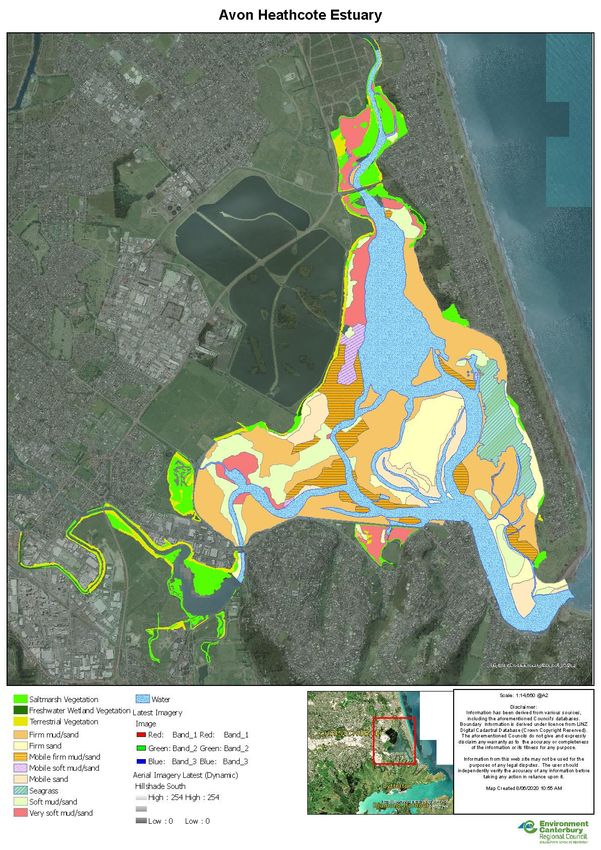
Vegetation also changed. Since 2013, findings from a few small-scale studies indicate a growth of
saltmarsh vegetation and a regrowth of seagrass. Saltmarsh plants such as Sarcocornia have expanded in
localised areas onto liquefaction sand (such as near Settlers Crescent at the Ōtākaro/Heathcote mouth)
or advanced inland as tidal water and brackish ground water moved inland. Figure 5 shows the existing
vegetation in June 2020. Based on this evidence, the status of saltmarshes on the estuary should be re-
assessed as a matter of priority. The need for more saltmarsh habitat is confirmed by the NIWA report of
June 2020 on water quality (NIWA 2020).
Other plant communities that supported important indigenous biota, however, have suffered extensive
die back. Juncus krausii stands in the lower Ōpāwaho/Heathcote declined years before the earthquakes
(Crossland 2003). Further, old growth habitats of upper saltmarsh (Plagianthus dominated) and tall
saltmarsh (Apodasmia and Juncus) have died back in and disappeared from the lower Ōtākaro/Avon,
Bexley, Raupō Bay and Rat Island Inlet areas. The Typha angustifolia/raupō stands at Raupō Bay, Bexley
Wetland and Naughty Boys Island have also disappeared. Overall, the hope is for further increases in
diversity and in habitats that provide better ecosystem services rather than a continued decline in
biodiversity.
Threats to biodiversity at present include development of the estuary edge, waterfowl such as Canada
geese, disturbance by predators, humans and dogs – especially dogs not under their owners’ control –
and human recreational activities such as windsurfing, kiteboarding, use of jet skis and drones without
regard for birdlife. Such threats from human encroachment compound those from the continued loss of
saltmarsh habitats.
The substantial liquefaction and uplift of large areas of the estuary bed during the CES 2010-2012
reduced the tidal prism resulting in about 20 per cent less inflow. Seismic activity tilted the estuary floor
so that the intertidal area at the mouth of the Ōtākaro/Avon River dropped below sea level, whereas the
mouth of the Ōpāwaho/Heathcote River rose (EOS Ecology 2011). These ruptures altered the habitats in
the northern part of the estuary that are necessary for waders, swamp birds, waterfowl and seabirds to
feed, roost, and breed. Along the built-up edges in its southern half, the estuary already had fewer
suitable habitats for these activities.
One of the important habitat types is seagrass, currently most abundant on the eastern side of the
estuary off Southshore. Seagrass provides food and habitat for numerous invertebrate and some fish
species. On the southern side changes in habitat induced by the earthquakes did not pose a problem for
bird life. But in the northern part the saltmarsh habitat continues to be flooded to a depth on spring
tides, potentially leading to plants rotting. Bird nests constructed within this marsh vegetation can also be
drowned. Roosting and feeding areas have also been lost. The replacement of saltmeadow and saltmarsh
by mudflats at Bexley Wetland resulted in a small net gain as mudflats are excellent feeding habitat. (See
Figure 4.) There remains a dire need to protect existing saltmarsh and to provide more safe
nesting/roosting islands within the estuary catchment. Planting programmes should be established for
saltmeadow and saltmarsh habitat.
172020 Estuary Management Plan
Figure 4: Map of vegetation in the estuary. Courtesy of Ecan
182020 Estuary Management Plan
Habitats for indigenous fish species are also in decline. Inanga/inaka eggs laid in river and stream bank
vegetation in late summer/autumn, when hatched, are carried downstream as larvae and spend the next
six months at sea. In the spring inaka migrate upstream where they continue to grow into adult fish.
Recent studies indicate that inaka migrate from the ocean into the estuary, rivers and streams to breed
but at present there is insufficient natural marsh grass habitat for this to be successful.
For birds, the establishment of artificial wetlands and associated habitat recovery provide foraging and
roosting areas for some species all year. The provision of artificial wetlands encouraged black-billed gulls
to nest on the estuary from 2003 onwards; the first time in 100 years that this now endangered species
nested on an estuary in the South Island. Since 2003, colonies have formed on constructed islands in
Charlesworth Reserve and Bexley Wetland. These provide safe habitats, except for predation by black-
backed gulls.
3.2.2 Pest species
The Wildlands Report (2017) listed exotic and native freshwater and terrestrial pest species present in
the estuary. Marine pest species such as Spartina can be found in specific locations as well as sea
lavender in the Ferrymead loop. These species are monitored, and attempts are made periodically to
eradicate them. There is also potential for non-indigenous marine algae to become established as has
happened in Whakaraupō/Lyttelton Harbour and around Banks Peninsula.
Pest animals around Te Ihutai include rats, hedgehogs, mice, weasels plus domestic and feral cats.
Domestic cats (predation) and domestic dogs (predation, disturbance, harassment) are problems that
need better community management.
Browsing and grazing animals such as rabbits pose a threat to the establishment and growth of native
marsh plants. Since the Burwood landfill was relocated, black-backed gulls moved to Te Ihutai and
evidence has shown that they are now a major threat to several bird species including the threatened
black-billed gulls.
Some bird species can at times also be considered pests. Large and increasing numbers of Canada geese,
black-backed gulls and black swans potentially contribute to the observed increase in enterococci counts
in the estuary from 2014 to 2019 (NIWA 2020).
This Plan encourages the Christchurch City Council to continue to invest effort and financial support to
increase trapping and the monitoring of pests in and around the estuary. Further research is needed on
the effect of large numbers of specific bird species.
3.2.3 Loss of kaitiakitanga
Guardianship and management of the environment according to the Ngāi Tahu world view requires
meeting the principles of Treaty partnership, as articulated in recent Treaty of Waitangi settlements
between the New Zealand government and iwi. Locally, abiding by these principles entails respect for
priorities relating to Te Ihutai as contained in the Mahaanui: Iwi Management Plan 2013 (Part 6.5).
Mahaanui provides the policy framework for the protection and enhancement of Ngāi Tahu values; and
outlines the desired outcomes for the relationship of Ngāi Tahu with natural resources across the area of
Canterbury between the Hurunui and Hakatere/Ashburton Rivers and Te Pātaka o Rākaihautū (Banks
Peninsula). This 2020 Estuary Management Plan will contribute to environmental management and
kaitiakitanga within the above takiwā by protecting and restoring mahinga kai and the biodiversity of the
estuary.
192020 Estuary Management Plan
3.2.4 Development of the estuary edge
As the link between rivers and the sea, estuaries act as a natural buffer from storms and extreme weather.
Yet development has made Te Ihutai and its margins more vulnerable to sea level rise and flooding events.
Most of the southern and eastern estuary edge is no longer natural; it is hard-engineered with hard, built
up edges and rip-rap walls. Sometimes rubble has been used for reclamation. Along the Southshore Spit
and at Redcliffs housing is built close to this hard estuary edge, while some residents have added jetties
and protruding decks. Other homeowners have illegally claimed parts of the foreshore as private
property.
The southern shoreline’s hard rock edges and sea walls, rebuilt after the CES 2010-2012, potentially have
altered the estuary’s hydrology and flow patterns beyond the changes in hydrodynamics and surface
elevation precipitated by the earthquakes. The loss of margin vegetation and stretches of intertidal
mudflats further reduced the foraging, roosting and nesting habitats for wading birds. Consequently, as
sea levels rise with the changing climate there is nowhere for estuary habitats to migrate. The most
significant implications from this loss of natural estuary margin include modification to water flows, loss
of important habitats for fish and birdlife, removal of buffers to natural hazard events such as flooding,
sea level rise and shoreline erosion, and contamination from uncontrolled fill used during reclamations.
The repair and strengthening of roads and construction of cycleways have contributed to the diminished
extent of natural, soft edge and intertidal mudflat feeding and roosting habitat. The Estuary Trust
recognises that paths built along bunds, for example, assist flood mitigation and are valuable recreational
resources. But it maintains that ecological values should be prioritised “when planning recreational
activities and public access to the Estuary” (Wildlands Report 2017, Executive Summary). Such works
should not be built at the expense of estuary habitat or have the effect of disturbing birds at locations
around the estuary shore where birds congregate. (See Section 1.2.)
3.3 Open space
3.3.1 Access and degradation of the estuary margins
The estuary margins differ markedly from how they looked before European settlement. Since 1850
natural wetlands and saltmarshes have been drained and/or filled: lost to development, roads, housing,
recreational facilities, and the construction of the Bromley oxidation ponds. The outcome is a shoreline
that detracts from the natural values of the estuary and decreases access to open space.
With urban development demand has grown for public access to the remaining open space. The presence
of structures such as boat ramps and sea walls has further constrained access. Managing the impact on
estuary ecology from public infrastructure works and from the assertion of private property rights by
landowners requires greater consideration by authorities.
3.3.2 Public access
Public access to the estuary edge is essential for people’s access to nature and supporting a sense of
place; however, we need to identify carefully which areas need to be protected. Road reserves enabling
access along the estuary edge were surveyed over 150 years ago when the emphasis was on development
not ecological values. Dynamic coastal processes have since eroded some of this publicly vested land,
leaving private property now directly fronting the estuary. To maintain public access in these areas is a
complex issue that involves balancing the rights of the public and property owners’ rights to privacy.
While non-consented structures impede public access in some places, in others estuary vistas and values
202020 Estuary Management Plan
have been compromised by poor planning that allowed commercial buildings on the foreshore without
regard for public benefit, as at Ferrymead.
Public access should be restricted to sections of the estuary shoreline where exclusion is essential to
protect wildlife, habitats, public assets and historic wāhi tapu from human disturbance and vandalism. Te
Huingi Manu Wildlife Refuge in the oxidation ponds complex is a case in point. Despite signs that state
there is “no through access”, Estuary Trust members and CCC staff documented that people were
increasingly trespassing into the wildlife refuge along the estuary edge beside the oxidation ponds. This
flouts the purpose of the wildlife refuge under the Wildlife Act. Already some birds are leaving the area.
Fortunately, new gates were installed to block access in mid-2020.
People routinely ignore signs all around the estuary, especially those concerning dog control. The CCC Dog
Control Policy requires immediate enforcement in areas where dogs are prohibited, such as Te Huingi
Manu Wildlife Refuge, Linwood Paddocks and the adjacent estuary shoreline. Dogs must be on a leash in
specific areas such as in Charlesworth Reserve and the Southshore Spit tip.
Given this documented disrespect for regulations and the mounting tensions between recreational use
and the estuary’s high ecological values, the Estuary Trust strongly recommends that an exclusion zone is
immediately established along the length of the estuary edge beside the Bromley oxidation ponds from
Sandy Point to Bridge St. For 25 years ornithologists have recommended such restrictions, and the need is
now urgent to safeguard the last remaining area of the estuary where birds can nest, roost and rest
undisturbed (Crossland 1993, Haase 1995, Kaldor 2019, Figueiredo 2020). The exclusion zone should be
accompanied by more barriers and new signage that clearly specifies “no access”. Additional public
notices should also explain why this is necessary, that is, to educate people about ecological and cultural
values and to encourage behavioural change.
Further, the Estuary Trust strongly recommends that seasonal restrictions be introduced. Both types of
restriction are common tools in conservation internationally. A winter restriction on recreational activities
on the exposed mud flats would reduce the risks of population decline, breeding failure and stress in birds
that over-winter there, for example oystercatchers. Restricting human activities in the cooler months of
April, May, June and July would allow birds access to “undisturbed foraging sites during their critical over-
wintering and moulting period” (Haase 1995).
In summary, recreational users should enjoy the values of the estuary but not compromise the ecology. To
address this, the Trust recommends that a full-time Te Ihutai Park Ranger is appointed to raise public
awareness about the impact of human disturbance on the estuary’s ecological and cultural values and to
enforce CCC by-laws.
3.4 Safe recreation
Te Ihutai provides for a wide variety of recreational activities including yachting, windsurfing,
kiteboarding, fishing and shellfish gathering, picnicking, canoeing and kayaking, paddle boarding, bird
watching, walking and jogging. Some uses compromise ecological values and others are incompatible.
More research is needed to identify what may be deemed responsible or suitable use, and where and
when, to prevent damage to the ecological and cultural health of Te Ihutai.
212020 Estuary Management Plan
In recent years the high levels of unmanaged shellfish harvesting within an area of the estuary in
McCormacks Bay and off Beachville Rd Redcliffs have generated widespread public concern. The Estuary
Trust shares this concern. Shellfish gathering is taking place all year round, intensifying pressure on the
ecosystem.
The Christchurch Coastal Pathway between Ferrymead and Sumner passes alongside the estuary giving
easier access to the favoured harvesting sites. The pathway is the outcome of a community partnership
between the Christchurch Coastal Pathway Group and the Christchurch City Council and is proving a
popular facility for cyclists and walkers to enjoy outdoor exercise. It caters for children, pedestrians and
dog walkers, cyclists, skateboarders, and people with impaired mobility. Action is needed to assess its
environmental impact once the final section is completed. There is an opportunity to use the pathway to
promote awareness of Te Ihutai and its ecological and cultural values.
Two sandy beaches along the Coastal Pathway route are popular sites for swimming: at the Beachville Rd
jetty and at Moncks Bay on the eastern side of the Christchurch Yacht Club. At the yacht club, young
people also enjoy jumping from a pontoon. Yet scientific results contained in the report on water quality
(NIWA 2020) indicate that the estuary is generally unsuitable for contact recreation. The lack of suitability
for swimming and the advisability of water management for shellfish gathering – both scientifically
demonstrated – are topics that the Estuary Trust recommends should be addressed in the next Coastal
Plan.
4 CLIMATE CHANGE
There is an urgent need for the threats posed by the changing climate to be incorporated into restoration
planning (NOAA 2011) as evidenced by this Plan. To achieve this, the Plan must include initiatives on how
to assess and incorporate sea level rise impacts into restoration planning and design for the estuary and
its catchment, to predict the relative sea level rise for the estuary over 50 years using relevant data and
information, and incorporate the modelled impacts into estuary management, including science and
monitoring.
4.1 Sea level rise and acidification
With rising sea levels, coastal wetlands such as saltmarsh are expected to migrate landward. This
migration will be constrained within Te Ihutai because it is an urban estuary with significant hard
infrastructure around the edge. Eelgrass, sea rush and saltmarsh species will be squeezed out as the
intertidal zone reduces in area. Fish species are expected to move with the transition in salinity, but
eventually some species such as flounder, eels and inanga will lose their feeding grounds as water depths
progressively increase. Wading birds will also be affected by a loss of habitat. Existing tidal mudflats will
be permanently drowned and will migrate into existing saltmarsh areas so existing saltmarsh will need to
re-establish at higher elevations in areas where pasture and saltmeadow currently exist.
Where there is no potential for landward migration alternative solutions will be necessary to increase the
estuary’s adaptive capacity, provide habitats for wildlife, and protect the surrounding suburbs from
adverse storm and weather events. In areas where there is space for ecological migration, non-salt
tolerant species will progressively die off with the rise in water levels and a succession to more salt
tolerant species with the same vertical zonation as currently present.
222020 Estuary Management Plan
Climate change is already causing ocean warming and ocean acidification. While the effects of these on
estuaries are largely unknown (carbon dioxide measurement is necessary to show ocean acidification),
there have been documented changes in the range shifts of fish and molluscs. Trend analyses show recent
increases in water temperature in the estuary (NIWA 2020). Increased water temperatures promote
macroalgae growth and hence increase eutrophication. Recent increases in water temperature may also
be interacting with nutrient loads.
Marine species that are most sensitive to ocean acidification have a narrow tolerance range for
environmental extremes and lack the physiological mechanisms to adapt to changing conditions. Some
dominant estuarine organisms have these mechanisms and are expected to be able to adjust to climate
change. Though the species present in Te Ihutai may change over time, it will be important to understand
the ecological roles different species provide so that biological diversity is sustained.
Increased resilience to the effects of coastal hazards demands a collective commitment to large-scale
restoration of saltmarsh and saltmeadow as well as brackish and freshwater vegetation in the estuary
catchment to increase and enhance the quality of habitat for wildlife and bolster the cultural and
ecological health of connected estuarine environments.
In 2019, the United Nations announced a Decade on Ecosystem Restoration from 2021 to 2030, urging
governments to enact Natural Climate Solutions, that is, ecological restoration. There is potential for Te
Ihutai to become a case study of actions to restore coastal ecosystems. Large-scale restoration in the
estuary catchment would bestow additional climate change benefits because “the fastest accumulation of
carbon occurs in … vegetated coastal habitats, such as mangroves, saltmarsh and seagrass beds. Here,
carbon can be sequestered 40 times faster per hectare than in tropical forests” (Monbiot 2019).
4.2 Tidal compartment and mouth dynamics
With rising sea levels, the volume of seawater in and out of the estuary on each tide will increase and
therefore will cause flooding to coastal land and at the same time increase the volume and height of the
sand shoals inside and outside the entrance. With the increase in the amount of water moving in and out
on each tide, it is expected that the estuary mouth channel width will change by between 40 to 50
metres. The CES 2010-2012 reduced the mouth’s width by 10-20 metres. Rising sea levels will also change
the ebb-delta regime and surrounding beaches.
The Estuary Trust recommends the modelling of water residence time in the estuary to assess changes to
water depth (bathymetry) since the CES 2010-2012 and the effects these changes could be having on
water quality and algal growth.
4.3 Drought
During dry seasons and drought conditions the stream flows can be expected to reduce in the spring fed
streams. Recharge to the aquifers will be reduced and groundwater levels can lower as a result, hence
decreased outflow from the springs. Additional contributions to the streams such as surface runoff will
also be significantly reduced under drought conditions.
Based on national assessments of droughts under climate change, droughts are likely to become more
frequent and severe in regions that are currently drought prone, notably eastern parts of Canterbury
(Mullan et al. 2005, Clark et al. 2011).
23You can also read