SHASS MOUNTAIN PEAT LANDSLIDE - Factual Report - rpsgroup.com - National ...
←
→
Page content transcription
If your browser does not render page correctly, please read the page content below
SHASS MOUNTAIN PEAT LANDSLIDE
Factual Report

                                        MGE0780RP0001
                                   Shass Mountain Peat
                                Landslide Factual Report
                                                     F01
                                       16th October 2020

                                       rpsgroup.com
FACTUAL REPORT

Document status

Version      Purpose of document                   Authored by            Reviewed by          Approved by         Review date

                                                   Various
F01          Factual Report                                               WM                   GC                  16/10/2020
                                                   (JOC and GMcE)

Approval for issue

Gareth McElhinney                                                                              16 October 2020

© Copyright RPS Group Limited. All rights reserved.
The report has been prepared for the exclusive use of our client and unless otherwise agreed in writing by RPS Group
Limited no other party may use, make use of or rely on the contents of this report.
The report has been compiled using the resources agreed with the client and in accordance with the scope of work
agreed with the client. No liability is accepted by RPS Group Limited for any use of this report, other than the purpose for
which it was prepared.
RPS Group Limited accepts no responsibility for any documents or information supplied to RPS Group Limited by others
and no legal liability arising from the use by others of opinions or data contained in this report. It is expressly stated that
no independent verification of any documents or information supplied by others has been made.
RPS Group Limited has used reasonable skill, care and diligence in compiling this report and no warranty is provided as
to the report’s accuracy.
No part of this report may be copied or reproduced, by any means, without the written permission of RPS Group Limited.

 Prepared by:                                                          Prepared for:

 RPS                                                                   Working Group under Ministers Supervision

 Lyrr 2,                                                               Department of Culture, Heritage and the Gaeltacht,
 IDA Business & Technology Park,                                       23 Kildare Street, Dublin, D02 TD30
 Mervue
 Galway,
 H91 H9CK

MGE0780RP0001 | Shass Mountain Peat Landslide Factual Report | F01 |
rpsgroup.com                                                                                                                Page i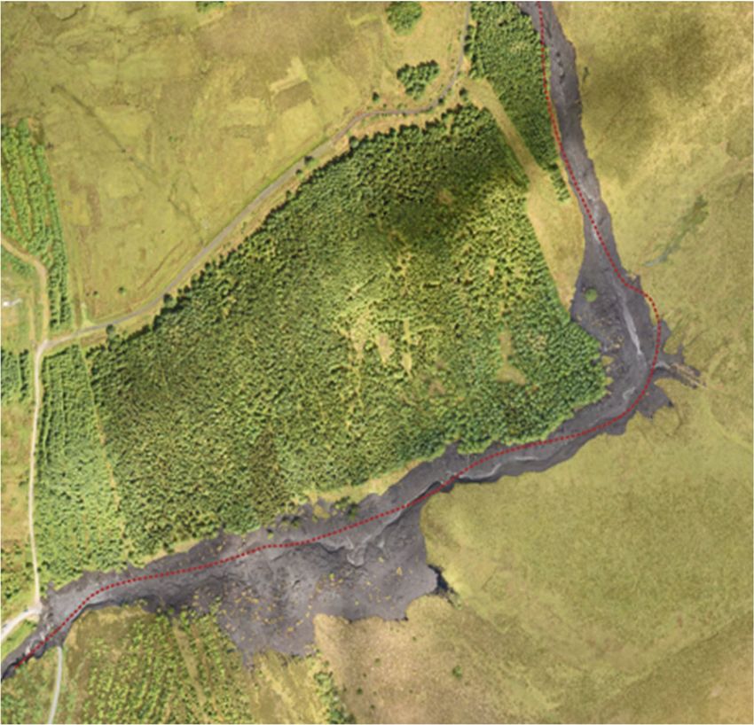
FACTUAL REPORT

Contents
1       INTRODUCTION ......................................................................................................................................1
        1.1 Overview ........................................................................................................................................1
        1.2 Developments on Shass Mountain, 1995 to Present.....................................................................2
2       THE SHASS MOUNTAIN PEAT LANDSLIDE EVENT ...........................................................................3
        2.1 Description of the Landslide and Lands Affected ..........................................................................3
        2.2 Estimated Areas and Volumes .......................................................................................................5
        2.3 Consultations with Relevant Bodies ...............................................................................................6
3       PEAT LANDSLIDES ................................................................................................................................8
        3.1 Types of Peat Landslides ...............................................................................................................8
        3.2 Historical Peat Slide Events ...........................................................................................................9
4       WEATHER DATA ..................................................................................................................................12
        4.1 Weather Forecast Prior to the Event............................................................................................12
        4.2 Weather Information Sources ......................................................................................................12
        4.3 Met Éireann Weather Observing Stations....................................................................................12
        4.4 Third-Party Weather Observing Stations .....................................................................................12
        4.5 Weather Observing Stations Summary........................................................................................13
5       CATCHMENT CHARACTERISTICS .....................................................................................................15
        5.1 Review of Available Information ...................................................................................................15
            5.1.1 General ...........................................................................................................................15
            5.1.2 Bedrock ...........................................................................................................................15
            5.1.3 Soils ................................................................................................................................15
            5.1.4 Environment ....................................................................................................................15
            5.1.5 Landslide Susceptibility ..................................................................................................16
        5.2 Surveys Undertaken Post-event ..................................................................................................16
        5.3 Peat ..............................................................................................................................................16
        5.4 Forestry ........................................................................................................................................17
        5.5 Protected Sites .............................................................................................................................17
6       IMPACT ON THE AQUATIC ENVIRONMENT AND LANDS ...............................................................22
        6.1 Catchment Overview ....................................................................................................................22
        6.2 Pre-event Water Quality ...............................................................................................................22
        6.3 Leitrim County Council Water Quality Chemistry Data ................................................................24
        6.4 Diffagher River Fisheries Data .....................................................................................................25
        6.5 Lough Allen ..................................................................................................................................25
            6.5.1 Water Quality ..................................................................................................................25
            6.5.2 Fish .................................................................................................................................25
            6.5.3 Protected Aquatic Species and Habitats ........................................................................26
        6.6 Field Survey 14th September 2020 ..............................................................................................26
            6.6.1 Downstream of Dawn of Hope Bridge ............................................................................26
            6.6.2 Upstream of Dawn of Hope Bridge .................................................................................28
            6.6.3 Flood Plain at Corcormick...............................................................................................28
            6.6.4 Flood Plain at Corchuill Lower and Derrindangan (north of R200).................................28
        6.7 Impact on Land, Property and Infrastructure ...............................................................................28
            6.7.1 Impact on Land ...............................................................................................................28
            6.7.2 Impact on Property .........................................................................................................31
            6.7.3 Impact on Infrastructure ..................................................................................................31
7       RISK ASSESSMENT .............................................................................................................................32
        7.1 Introduction ..................................................................................................................................32
        7.2 Methodology .................................................................................................................................32
        7.3 Areas ............................................................................................................................................32

MGE0780RP0001 | Shass Mountain Peat Landslide Factual Report | F01 |
rpsgroup.com                                                                                                                                            Page ii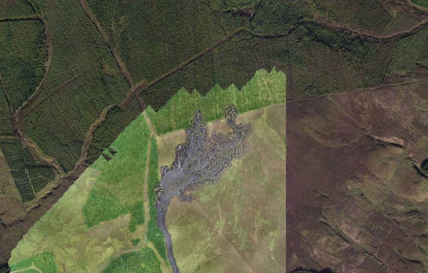
FACTUAL REPORT

                  7.3.1 Area A .............................................................................................................................32
                  7.3.2 Area B .............................................................................................................................32
         7.4      Risk to Land, Property and Infrastructure ....................................................................................36
         7.5      Risk to Life....................................................................................................................................36
8        REMEDIAL WORKS ..............................................................................................................................37
         8.1 Emergency Works ........................................................................................................................37
         8.2 Remedial Measures to be Completed in the Short Term .............................................................38
             8.2.1 Works at Dawn of Hope Bridge ......................................................................................38
             8.2.2 Measures to Protect Water Quality .................................................................................38
             8.2.3 Areas of Inundation in Corcormick and Derrindangan ...................................................39
             8.2.4 Geotechnical Investigations ............................................................................................41
         8.3 Procurement Options for Short-term Remedial Measures...........................................................41
         8.4 Medium to Long Term Measures .................................................................................................42
             8.4.1 North of the Dawn of Hope Bridge ..................................................................................42
             8.4.2 Areas of Inundation in Corcormick and Derrindangan ...................................................43
             8.4.3 Water Quality Measures .................................................................................................43
9        PRELIMINARY COST ESTIMATES FOR REMEDIAL MEASURES ....................................................44
         9.1 Remedial Measures .....................................................................................................................44
         9.2 Purchase of Land / Compensation ...............................................................................................45
         9.3 Excavation of Peat and Disposal at Suitable Receptor Site ........................................................45
10       CONCLUSIONS AND RECOMMENDATIONS .....................................................................................46
         10.1 Conclusions ..................................................................................................................................46
              10.1.1 The Event........................................................................................................................46
              10.1.2 Weather Data ..................................................................................................................46
              10.1.3 Impact on the Aquatic Environment ................................................................................46
              10.1.4 Land Inundated ...............................................................................................................46
              10.1.5 Risk Assessment ............................................................................................................46
              10.1.6 Remedial Works..............................................................................................................47
         10.2 Recommendations .......................................................................................................................47

Tables
Table 2.1 Summary of Consultations .................................................................................................................7
Table 3.1 Historical Peat Slide Events .............................................................................................................10
Table 4.1 Nearest Met Éireann Weather Observing Stations ..........................................................................12
Table 4.2 Third-party Weather Station Information ..........................................................................................12
Table 4.3 Rainfall in June 2020 ........................................................................................................................13
Table 5.1 Boleybrack Mountain SAC Habitats of Qualifying Interest within Landslide Headscarp ..................20
Table 5.2 Potential Pressures and Threats to Boleybrack Mountain SAC .......................................................21
Table 6.1 Watercourse Names and EPA Codes ..............................................................................................22
Table 6.2 EPA Biological River Monitoring Data: Diffagher Sub-Catchment ...................................................24
Table 6.3 Location of Watercourse Field Surveys............................................................................................26
Table 6.4 Summary of Extent of Damage on Agricultural and Forested Land .................................................29
Table 9.1 Preliminary Cost Estimates of Remedial Works ...............................................................................44
Table 9.2 Estimated Land Purchase Costs ......................................................................................................45

MGE0780RP0001 | Shass Mountain Peat Landslide Factual Report | F01 |
rpsgroup.com                                                                                                                                               Page iii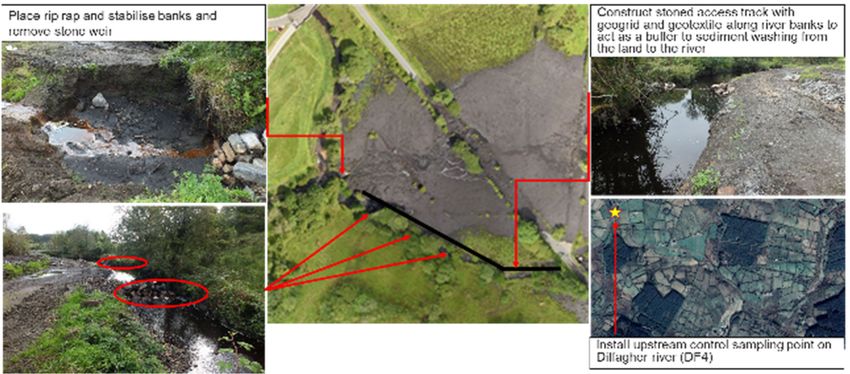
FACTUAL REPORT
Figures
Figure 1-1 Extents of the Landslide ....................................................................................................................1
Figure 1-2 Developments on Shass Mountain, 1995 to Present ........................................................................2
Figure 2-1 Extent of the Landslide and Sector Lengths (total = 8.45 km) ..........................................................3
Figure 2-2 Starting Location of Landslide ...........................................................................................................4
Figure 2-3 Drainage Patterns from iCRAG Research ........................................................................................5
Figure 2-4 Inundated areas in the townlands of Corcormick (north) and Corchuill Lower and
Derrindangan .................................................................................................................................6
Figure 3-1 Elements of the Bog Flow/ Bog Slide on Shass Mountain Event .....................................................8
Figure 4-1 Daily rainfall data for February-June 2020 ......................................................................................14
Figure 5-1 Perimeter drain revegetated with sphagnum moss on the edge of the forestry at Shass
Mountain.......................................................................................................................................17
Figure 5-2 Protected Sites in the vicinity of Shass Mountain and Lough Allen ................................................19
Figure 6-1 Diffagher Catchment and Field Survey Locations ..........................................................................23
Figure 6-2 Agricultural and Forested Land Parcels ..........................................................................................30
Figure 7-1 Risk Assessment Extents................................................................................................................33
Figure 7-2 Approximate Peat Depths ...............................................................................................................34
Figure 7-3 Approximate Slope Angles of Blanket Bog .....................................................................................35
Figure 8-1 Completed Remedial Works at the Dawn of Hope Bridge ..............................................................37
Figure 8-2 Completed Remedial Works at Corcormick ....................................................................................37
Figure 8-3 Eroding Banks at Culverts of Dawn of Hope Bridge .......................................................................38
Figure 8-4 Peat on Corry Strand, Lough Allen .................................................................................................39
Figure 8-5 Proposed Works at Corcormick East of the Local Road .................................................................40
Figure 8-6 Proposed Works at Corcormick West of the Local Road ................................................................40
Figure 8-7 Proposed works at Radharc na tSeipeal Road ...............................................................................41
Figure 8-8 Potential dewatering and rock weirs at Dawn of Hope Bridge ........................................................43
Figure C.10-1 Lough Allen: Total Phosphorous, P(mg/l), 2008-2020 ................................................................5
Figure C.10-2 Lough Allen: Chlorophyll a(ug/l), 2007-2020 ...............................................................................6
Figure C.10-3 Lough Allen: Ammonia as N (mg/l), 2007-2020 ..........................................................................6
Figure C.10-4 Lough Allen: Tru Colour (PTCo units), 2011-2020 ......................................................................7
Appendices
Appendix A Aquatic Ecology References:
Diffagher River Water Quality Chemistry
Lough Allen Water Quality Data
Field Survey Macroinvertebrate Fauna
MGE0780RP0001 | Shass Mountain Peat Landslide Factual Report | F01 |
rpsgroup.com Page iv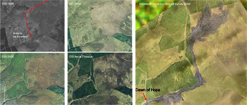
FACTUAL REPORT

1           INTRODUCTION
1.1         Overview
A blanket bog landslide occurred on Shass Mountain, north-east of Drumkeeran, Co. Leitrim on the 28th June
2020, approximately 1.2km upstream of the Dawn of Hope Bridge. The area affected by the peat landslide is
shown in red outlined in Figure 1-1.
This document is a factual report on the event, a review of the catchment characteristics that may have
contributed to the landslide and the aquatic ecology of the catchment before and after the event. The report
also includes a risk assessment of the situation with respect to the stability of the remaining bog within the
immediate slopes affected by the landslide and recommendations for short term mitigation measures and
further studies required.

                                                                                                   Shass
                                                                                                   Mountain

                                                                                          Dawn of Hope Bridge

                                                         Corcormick

                                                                       Greyfield Bridge

                       Derrindangan

Figure 1-1 Extents of the Landslide

MGE0780RP0001 | Shass Mountain Peat Landslide Factual Report | F01 |
rpsgroup.com                                                                                                  Page 1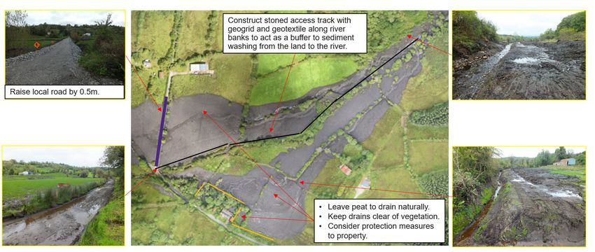
FACTUAL REPORT

1.2         Developments on Shass Mountain, 1995 to Present
The OSi online mapviewer provides orthophotography imagery of Ireland and includes imagery of Shass
Mountain for the years 1995, 2000, 2005, and Aerial Premium taken after 2013. Figure 1-2 provides
screenshots of the orthophotography imagery from OSi.
As is seen in the progression of the orthophotography, the main development on Shass Mountain in the
period 1995 to present is the planting of forestry in 1997 (approximately outlined in red to the below image
for pre-planting in 1995) which has grown over time.

Figure 1-2 Developments on Shass Mountain, 1995 to Present

MGE0780RP0001 | Shass Mountain Peat Landslide Factual Report | F01 |
rpsgroup.com                                                                                             Page 2
FACTUAL REPORT
2 THE SHASS MOUNTAIN PEAT LANDSLIDE EVENT
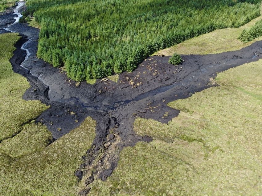
2.1 Description of the Landslide and Lands Affected
The landslide occurred within an area blanket bog on Shass Mountain, north-east of Drumkeeran, Co.
Leitrim on the 28th June 2020, approximately 1.2km to 1.4km upstream of the Dawn of Hope Bridge. The
evacuated peat travelled within the existing watercourses where it resulted in flooding of the flood plain in the
townlands of Corcormick and Derrindangan. The majority of the peat carried downstream of the Dawn of
Hope bridge remains on these flood plains. The Diffagher River carried some peat sediment and other debris
to Lough Allen, approximately 8.45km from the starting point, where it has washed up on the shoreline, e.g.
at Corry Strand. The trajectory of the landslide with distances from the headscarp is shown in Figure 2-1.
Headscarp
1.42km
Dawn of Hope Bridge
3.22km
Corcormick
0.72km Confluence of
Diffagher and
Tullintowell rivers
Derrindangan
1.44km
Corry Strand
Lough Allen
1.65km
Figure 2-1 Extent of the Landslide and Sector Lengths (total = 8.45 km)
MGE0780RP0001 | Shass Mountain Peat Landslide Factual Report | F01 |
rpsgroup.com Page 3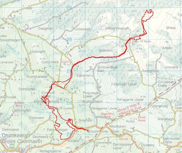
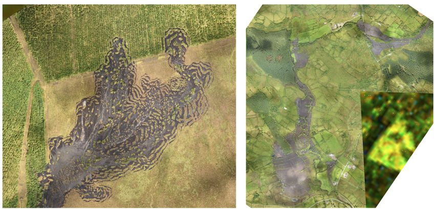
FACTUAL REPORT

The slide occurred after a period of prolonged dry weather followed by heavy rainfall. The landslide occurred
on a moderately south sloping upland bog, approximately 1.42 km upslope from the Dawn of Hope bridge.
The area of the headscarp where the initial slide occurred is approximately 0.08km2, or 8 hectares, (shown in
Figure 2-2), and is approximately 200m wide by 450m long, extending from the forestry in the northern
section to the stream channel in the southwestern corner. The landslide appears to have formed within the
surficial peat layer estimated to be up to 5m thick. The headscarp and the islands of peat and trees left after
the landslide occurred can be seen in Figure 2-2.
The specific location where the landslide originated cannot be definitively stated. However, it is possible that
the slide started in the area within the red dashed circle as shown in Figure 2-2. This hypothesis is based on
the visible subsoil surface underneath the blanket bog which is a potential slip plane. The evacuation of peat
from this area may have resulted in the destabilisation of the peat further upslope which is why there are
islands of intact bog and standing trees within the affected area which ‘floated’ downslope with the peat. The
subsoil layer under the blanket bog is also visible in places.
This is just one hypothesis of the timeline of the slide based on the current available information and
discussion with relevant parties. To more accurately state causes of the slide, further studies would be
required which have been listed in Section 10.2, Recommendations. This could include reviews of land-use;
land-use change; drainage patterns; peat depths and properties; clay layer properties, extent and shape; and
the impact of weather patterns on the landscape.

Figure 2-2 Starting Location of Landslide

Work carried out by the Irish Centre for Research in Applied Geoscience (iCRAG) shows the inferred pre-
slide surface drainage pattern (Figure 2-3) which seems to converge on the area of the hypothesized slip
area in Figure 2-2. The flow direction in the image is from north to south.

MGE0780RP0001 | Shass Mountain Peat Landslide Factual Report | F01 |
rpsgroup.com                                                                                              Page 4
FACTUAL REPORT
Figure 2-3 Drainage Patterns from iCRAG Research
The GSI Landslide Susceptibility Map indicates the site of landslide was in an area of land classified as
having a low to moderately low susceptibility to landslide. The GSI website describes the site as follows:
‘It is primarily mapped as blanket peat on slopes of 3-10 degrees. The national map shows
that the highest number of landslides recorded in this category are those of peat in the 3-6
degree range. Landslides mapped in this category account for approximately 12% of all
mapped landslides. The susceptibility and the heavy rainfall on Saturday is the likely cause.
The National Landslide database also shows a landslide event mapped in 2006 and listed as
a bog burst.’
The contours indicate the pre-slip slope within the area likely to have initially failed was greater than 4
degrees.
Once released, the evacuated peat formed a slurry in the mountain stream, which rises north of the Dawn of
Hope Bridge, and flowed downstream largely within the river channel. Debris from the slide lodged behind
the Dawn of Hope Bridge, blocking it. Subsequently, the mass of peat and debris overtopped the bridge,
before continuing downstream within the existing stream channel. The bridge, while damaged, remained
intact. Damage to the bridge was evident with displaced stones located at the bottom of the bridge on the
downstream edge.
Approximately 2.6km downstream of the Dawn of Hope Bridge, the peat spread out over a flat area of land in
the townland of Corcormick. The peat impacted on a number of local roads and before re-joining the local
watercourses and flowing south.
Beyond Corcormick, the stream joins the Tullintowell stream and flows onward to the confluence with the
Diffagher River, approximately 1km downstream from Corcormick. A little further downstream, a further flood
plain is encountered in the townlands of Corchuill Lower and Derrindangan, just north of the R200 road.
2.2 Estimated Areas and Volumes
For the purposes of this report it is assumed that the main constituent of the peat material mobilised and
deposited in the event is water.
Preliminary estimations of affected areas based on visual observations and desktop measurements on the
area of the landslide are illustrated in Figure 2-4 and summarised below:
Approximate area of lands affected by the landslide over the 7km length including stream and river
channels, forestry, agricultural land, etc. – 553,000 m2 (55.3ha).
MGE0780RP0001 | Shass Mountain Peat Landslide Factual Report | F01 |
rpsgroup.com Page 5FACTUAL REPORT
Approximate area of evacuated / slipped land – 119,000 m2 (11.9 ha). This is the area north of the
Dawn of Hope Bridge.
Approximate area in which debris has been deposited – 434,000 m2 (43.4 ha) from the Dawn of Hope
Bridge to Derrindangan.
The main deposition of peat material occurred in the townlands of Corcormick, Corcuhill Lower and
Derindangan.
Approximately 70,000m2 (7 ha) of land was directly impacted in Corcormick. Assuming an average of
0.8m of peat material was deposited in this area, then the volume of peat material within the flood plain
at Corcormick equates to 56,000m3 (56,000 tonnes).
Approximately 260,000m2 (26 ha) of land was directly impacted in Corcuhill Lower/ Derrindangan.
Assuming an average of 0.4m of peat slurry was deposited in this area, then the volume of peat material
within the flood plain at Derrindangan equates to 104,000m3 (104,000 tonnes).
The combined volumes of material deposited at Corcormick and Corcuhill Lower/ Derrindangan is 160,000m3
(160,000 tonnes).
0.04km2
0.03km2
Corcormick
0.02km2
0.23km2 0.01km2
Derrindangan and Corchuill Lower
Figure 2-4 Inundated areas in the townlands of Corcormick (north) and Corchuill Lower and
Derrindangan
2.3 Consultations with Relevant Bodies
Consultation has taken place with several bodies list below with notes provided in Table 2.1.
Leitrim County Council (LCC);
Department of Agriculture, Food and the Marine (DAFM);
MGE0780RP0001 | Shass Mountain Peat Landslide Factual Report | F01 |
rpsgroup.com Page 6FACTUAL REPORT
National Parks and Wildlife Service (NPWS);
Inland Fisheries Ireland (IFI);
Irish Farmers Association (IFA);
Teagasc;
Geological Survey of Ireland (GSI);
Environmental Protection Agency (EPA);
Local Authorities Water Programme (LAWPRO) and the Catchment Assessment Team; and
3rd Level Education Inst. (UCD/ Maynooth/ Trinity and Queen’s University Belfast).
Table 2.1 Summary of Consultations
Relevant Body Summary of Consultation
LCC Project management role by LCC of the overall project.
Access to data provided and coordination of steering group.
DAFM Contact provided for the Forestry Service. Requested information on forestry planation
upslope of landslide headscarp.
Document and maps received on area of lands affected.
NPWS Discussion on restoration of peat and lessons learnt from the Corrib Gas Project.
IFI Discussion on actions from previous slides and actions to be taken at this site.
IFA IFA interested in what happened and why to prevent repeat occurrences. Interested in
pilot scheme to provide alternative to farmers to use peatlands for carbon sequestration
or similar as opposed to forestry planting or agriculture.
Local farmers requesting works to provide drainage to land.
Teagasc Discussion environmental value of land with possibilities for results based argi-
environmental scheme.
GSI Requested hourly data from Met Eireann and carried out check for LiDAR survey pre-
slide. Directed to Landslide Susceptibility mapping and online landslide database.
EPA EPA will provide access to background water quality monitoring data and any other
assistance required.
LAWPRO and Lough Allen is a Priority Area for Action (PAA) but not the rivers which connect to the
Catchment lough. No sampling will take place at these sites until summer 2021 and the area may be
Assessment Team carried through to the next cycle. Catchment Assessment Team assess pressures in
wider area and feed this to the relevant body with actions or recommendations for
improvement. These are then assessed by the EPA.
3rd Level Provision of surveys including LiDAR post-slide, orthomosaic photography and drone
Education Inst. footage. Installation of piezometers and samples taken for analysis.
(UCD/ Maynooth/ Provision of academic papers and useful discussion on historical slide events and the
Trinity and potential mechanisms of this slide.
Queen’s University
Discussion on restoration of peatlands and prevention of sediment transport in long term
Belfast)
scenario.
MGE0780RP0001 | Shass Mountain Peat Landslide Factual Report | F01 |
rpsgroup.com Page 7FACTUAL REPORT
3 PEAT LANDSLIDES
3.1 Types of Peat Landslides
There are six types of peat landslides or mass movements described in the literature:
1. Bog burst (flow failure in raised bogs)
2. Bog flow (flow failure in blanket bogs)
3. Bog slide (shear failure and sliding of blanket bogs)
4. Peat slide (shear failure at the peat and mineral layer interface in blanket bogs)
5. Peaty-debris slide (shear failure within the mineral substrate beneath blanket bogs)
6. Peat flow (natural failures including flow failure by head loading)
In the above “peat” refers to any partly decomposed or undecomposed plant material and “bog” refers to an
accumulation of peat.
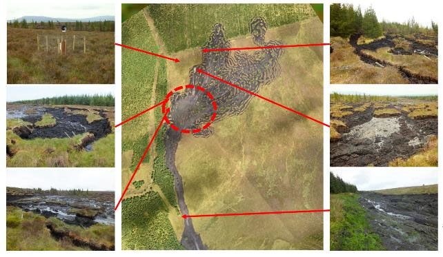
The peat landslide on Shass Mountain appears to have been predominantly a bog flow / bog slide event
where the semiliquid basal peat activated in the headscarp and flowed downhill.
The landslide event on Shass Mountain presents all of the typical elements of a bog flow/ bog slide event
(illustrated in Figure 3-1), which are:
1. Hypothesized source zone where the failure started;
2. Peat debris zone containing debris, peat blocks and mounds;
3. Zone of tension cracks and fissures in the adjacent peat mass; and
4. Downslope run-out zone, which stretches from above the head scarp on Shass Mountain above the
Dawn Hope bridge to the R200 at Derrindangan, approximately 6.6km.
Shass Mountain 4
3
4 Corcormick
2 3
Derrindangan
1
4
3
Figure 3-1 Elements of the Bog Flow/ Bog Slide on Shass Mountain Event
MGE0780RP0001 | Shass Mountain Peat Landslide Factual Report | F01 |
rpsgroup.com Page 8FACTUAL REPORT 3.2 Historical Peat Slide Events Numerous peat slippage events have occurred in Ireland and the UK over the last few decades. This section highlights some of these events while looking at the site dependent and site independent causes that may have triggered them. Site dependent causes include land use, peat depth, slope angle, slope morphology, hydrogeology and the interface of the peat and underlying stratum. Site independent causes include intense rainfall events, the appearance of tension cracks due to dry weather, loading due to construction, excavation or peat cutting and historical land uses. Details of each slippage are provided in Table 3.1, including their location, length, volume, slope and contributing factors, where known. Most of the information has been gathered from the GSI Landslide Susceptibility Map, academic papers and newspaper articles. Weather was the major contributing factor to many of the peat slippage events discussed in Table 3.1. The sites of most events were subjected to prolonged spells of rainfall in the weeks or months prior to the event or were subjected to intense localised showers just before the event. Many of these slides took place in the latter months of the year, i.e. August to December, correlating to the likelihood for increased rainfall events after dry summer periods. After prolonged rainfall, the unit weight of peat can increase significantly. If the area has experienced extended dry spells and warm weather, tension cracks can appear in the peat mass as it becomes desiccated. These cracks can expose the underlying substrate and can increase the chances of shear failure occurring at the peat-rock interface, particularly if the underlying rock is impermeable or has low permeability. After intense showers, the pressure in the water in the peat can increase rapidly, increasing the likelihood of peat slide. Another factor that contributes to landslides is the angle of the slope surface, with steeper slopes being more susceptible to slippage. However, the events discussed in Table 3.1 show that the range for peat slippages can occur on slopes with angles as low as 3° right up to 60°. Some of the events summarised in Table 3.1 were caused by human interactions. The Derrybrien landslide in 2003 that was caused by excavation works for a wind turbine foundation. This landslide initiated as the foundation was being constructed in a zone of particularly weak peat. This zone was also acting as a natural drainage channel. The Kerry Bogslides at Ballincollig-Maghanknockane in 2008 were caused by turf cutting practices. The top metre of the turf was cut into vertical strips, effectively creating tensions cracks that allowed rain water to enter. The Kerry Bogslides were aggravated by inclement weather in the weeks before the event. The extent of the peat slide depends on a number of factors including the site’s topography, the type of material evacuated (peat, peat-debris mix etc.), weather conditions in the weeks or months up to and at the time of the event, the catchment slope / flow paths and obstructions in the landslide’s path. The peat slides discussed in Table 3.1 range from 300m to more than 3,000m in length. The volume of displaced material ranged from 190m3 up to 450,000m3. MGE0780RP0001 | Shass Mountain Peat Landslide Factual Report | F01 | rpsgroup.com Page 9
FACTUAL REPORT

Table 3.1 Historical Peat Slide Events
  Event Location            Date       Slide              Displaced    Slope    Contributing Factor(s)                                 Other Comment
                                       Length             Volume       (°)
  Derrybrien,               16/10/2003 2,450m             450,000m3
FACTUAL REPORT
Event Location Date Slide Displaced Slope Contributing Factor(s) Other Comment
Length Volume (°)
Co. Mayo
Clare Island, 14/12/2006 N/A N/A N/A Heavy rainfall.
Co. Mayo
Gleniff, 14/12/2006 10° Water trapped in a hollow burst its banks after six 15m high mudbank blocked 300m section
Co. Sligo weeks of heavy rainfall. of road.
Cuilcagh, 21/08/1992 300m 9,100m3 N/A 80mm rain recorded in the days prior to event. 75m (L) x 42m (W) rupture.
Co. Fermanagh 22/08/1992
Carrowmaculla, 25/11/1979 N/A 20,000m3 N/A Heavy rainfall in months preceding event. 100m (W) x 2m (D) rupture.
Co. Fermanagh
Glen Docherty, 08/2015 N/A 190m3 (89m3 33° Heavy rainfall in months preceding event 22m (L) x 9m (W) rupture.
Scotland peat) Localised cloudburst.
Teesdale, 06/07/1963 N/A 4,000m3 and 9°-17° Heavy rainfall in June and early July 1963. Slide occurred on each side of the valley.
England 1880m3 Saturated peat mass and slope of valley sides.
Shetland Islands, 19/09/2003 N/A 23,000 - 4° Extreme rainfall Multiple events occurred throughout
Scotland 59,000m3 islands.
Same date as the Pollatomish event.
MGE0780RP0001 | Shass Mountain Peat Landslide Factual Report | F01 |
rpsgroup.com Page 11FACTUAL REPORT
4 WEATHER DATA
4.1 Weather Forecast Prior to the Event
A Raidió Teilifís Éireann (RTÉ) weather report from Friday 26th June 2020 forecast that wet weather would
be experienced across the north west of Ireland from the 26th to the 28th June. This was due to a low-
pressure system sitting just north of Ireland causing bands of organised spells of rain across Connacht and
Ulster with some localised thunderstorm activity across the north west.
A yellow rainfall warning was issued for Donegal, Leitrim, Mayo and Sligo on the 26th June with the RTÉ
report anticipating 40-60mm of rain in these counties. This would increase the risk of spot flooding or flash
flooding in higher terrain areas.
4.2 Weather Information Sources
For this report, weather data was obtained from four official Met Éireann and six third-party weather
observing stations. The weather data obtained from the official Met Éireann weather observing stations
included information on hourly, daily and monthly temperatures and rainfall levels. Only rainfall data was
obtained from the third-party weather stations. All weather data was taken from:
Met Éireann website (Link - https://www.met.ie/climate/available-data/monthly-data) or
data.gov.ie website (Link -https://data.gov.ie/).
The closest official Met Éireann weather observing station is located at Markree Castle, Co. Sligo, around
24.7km west of the Dawn of Hope Bridge. The closest third-party weather station is situated 13.4km north of
the Dawn of Hope bridge at Manorhamilton, Co. Leitrim.
4.3 Met Éireann Weather Observing Stations
The locations of the four nearest Met Éireann weather observing station are contained in Table 4.1. Total
monthly rainfall data was obtained from four official Met Éireann Weather Observing Stations for the period
from the 1st January 2017 to 13th September 2020. Daily and hourly weather data was obtained for the four
official Met Éireann Weather Observing Stations. The mean total rainfall for 1981-2010 was also obtained to
allow a comparison to be made.
Table 4.1 Nearest Met Éireann Weather Observing Stations
Distance to Dawn of
Weather Station Location Northing Easting
Hope bridge
Markree AWS Co. Sligo 54.175 N -8.456 W 24.7km west
Finner AWS Co. Donegal 54.4939N -8.2431W 34.1km north
Ballyhaise AWS Co. Cavan 53.9424N -8.3269W 53.1km east
Mount Dillon AWS Co. Roscommon 53.727 N -7.981 W 53.7km south
4.4 Third-Party Weather Observing Stations
Six third-party weather observing stations were identified within close proximity to the site of the landslide as
summarised in Table 4.2. Monthly and daily weather data was also been obtained for these sites.
Table 4.2 Third-party Weather Station Information
Distance to Dawn of
Weather Station Location Northing Easting
Hope bridge
Manorhamilton (Amorset) Co. Leitrim 54.307 N -8.182 W 13.4km north
Dromahair (Market Street) Co. Leitrim 54.232 N -8.297 W 14.2km west
MGE0780RP0001 | Shass Mountain Peat Landslide Factual Report | F01 |
rpsgroup.com Page 12FACTUAL REPORT
Distance to Dawn of
Weather Station Location Northing Easting
Hope bridge
Drumshanbo Co. Leitrim 54.061 N -8.061 W 15.7km south
Cuilcagh Mountains Co. Cavan 54.166 N -7.801 W 19.0km east
Aughnasheelan (Miskawn) Co. Leitrim 54.085 N -7.869 W 19.2km south-east
Keshcarrigan G.S. Co. Leitrim 54.018 N -7.942 W 22.4km south
4.5 Weather Observing Stations Summary
Figure 4-1 shows the daily rainfall recorded at the four Met Éireann and six third-party weather observing
stations.
February 2020 was a particularly wet month with all weather stations recording well above average rainfall.
In February, Markree AWS recorded a 262% increase on the mean total rainfall for 1981-2010 with 240mm
of rain falling. Similarly, Ballyhaise and Mount Dillon experienced greater than 290%, with 213mm and
225mm falling respectively.
Relatively dry spells were recorded at all weather stations throughout the months of March, April and May,
with 66 days recording 1.0mm of rain or less at both the Finner Camp and Mount Dillon stations, 68 days at
Ballyhaise and 92 days at Markree. Met Éireann describes days with 1.0mm of rainfall or more as ‘Wet
Days’. The horizontal dashed red line on Figure 4-1 indicates the 1.0mm limit. It can clearly be seen that
there are many days in March, April, May and June that have less than 1.0mm of rainfall at all ten
observations sites. The months of March, April and May also saw above average temperatures.
The relatively ‘dry’ period seen between March and May was followed by a particularly wet June, with all
weather stations recording rainfalls greatly in excess of their 30-year average. Particularly heavy rainfall
events were experienced on the 23rd, 25th, 27th and 28th June 2020. Table 4.3 highlights the rainfall figures
recorded at the third-party weather stations, along with the total June and average June rainfalls. The
Manorhamilton (Amorset) station, the nearest station to the Dawn of Hope bridge, experienced almost 61mm
of rainfall on the day of the event, while 101.7mm of rain fell in the week leading up to the event.
Table 4.3 Rainfall in June 2020
Cumulative Rainfall on Dates in June Preceding the
June
Rainfall for Peat Landslide (mm)
June Total Average
Weather Station 21st –
2020 (mm) 1981-2010
27th June 23rd 25th 27th 28th
(mm)
(mm)
Manorhamilton
218.2 88.9 101.7 23.6 24 38.2 60.6
(Amorset)
Dromahair (Market
179.0 84.5 81.9 25.2 16.7 12.8 47.5
Street)
Drumshanbo 171.1 80.2 70.3 20.6 2.7 23.6 30.7
Cuilcagh
243.5 99.1 99.1 26.4 11.5 18.5 47.3
Mountains
Aughnasheelan
220.4 90.2 74.6 19.4 0.7 32.8 42.1
(Miskawn)
Keshcarrigan G.S. 129.5 74.5 51.8 18.1 0.8 18.5 23.8
MGE0780RP0001 | Shass Mountain Peat Landslide Factual Report | F01 |
rpsgroup.com Page 13FACTUAL REPORT
Figure 4-1 Daily rainfall data for February-June 20201
1
Note: [M] denotes Met Éireann Weather Observing Station; [P] denotes Private (Third-Party) Weather Observing Station
MGE0780RP0001 | Shass Mountain Peat Landslide Factual Report | F01 |
rpsgroup.com Page 14FACTUAL REPORT 5 CATCHMENT CHARACTERISTICS 5.1 Review of Available Information 5.1.1 General A desktop review of available data was carried out to broadly determine the characteristics and sensitivities of the surrounding environment. Geographic Information Systems (GIS) software was used to map key environmental features and designations in the area where the landslide occurred. In order to classify the landscape and topography of the area surrounding the landslide event, a variety of GIS datasets were cross-referenced and examined. 1:50,000 scale Discovery Series Mapping provided by Ordnance Survey Ireland (OSi) was used, in the first instance, to identify local roads, settlements, amenities, features and topography. The landslide event visibly encroaches on three local roads (including the Dawn of Hope bridge) as per the OSi Discovery Series mapping. The landslide event terminates just short of the R200, which is a regional road that traverses the Leitrim/Cavan border and, provides connectivity between the village of Drumkeeran and the N87 national route south of Swanlibar. Overall, the OSi Discovery Series mapping gives context to the landslide event environment. The local area can be characterised as rural, with the village of Drumkeeran in the southwest representing the largest settlement in the vicinity. The source of the landslide is located on Shass Mountain. There are also several watercourses in the area, with the Diffagher River experiencing the most significant effects of the landslide event. Each of these features are discussed individually in greater detail below. 5.1.2 Bedrock An assessment of the geology within the area of the landslide was carried out using available GIS datasets from the GSI. At the location of the landslide headscarp the bedrock geology mapping indicates dark grey silty sideritic shale. The bedrock changes to shale and minor turbiditic sandstone through the central part of the affected area. The lower reaches of the landslide affected area, around Derrindangan, is in bedrock comprised of grey/black shale with minor limestone. 5.1.3 Soils CORINE (Co-ORdinated INformation on the Environment) Land Cover 2018, EPA (Environmental Protection Agency) soils and 10 metre contour mapping were used to determine the main landscape features within the catchment. Regarding topography, the terrain is mountainous and is characterised by a significant fall in elevation from an altitude from the landslide headscarp of approximately 280 m O.D. to its termination point approximately 50 m O.D. According to the CORINE and EPA soils datasets, the terrain on the mountainside where the landslide began is comprised of blanket peat, transitioning to coniferous forest and woodland scrub further downslope. The land encompassing the lower half of the landslide area is predominantly agricultural, characterised by shallower topography compared to the headscarp area. The soils are also indicative of such, with much of the landslide inundation zone comprising alluvium-rich soils (influence of the Diffagher River) and evidence of cut soils at the landslide’s termination point (agriculture). 5.1.4 Environment Regarding designated and protected sites, there are several Natural and Proposed Natural Heritage Areas (NHA; pNHA) in the wider environment of the landslide. However, the landslide headscarp is located within the indicative boundaries of a Special Area of Conservation (SAC), namely Boleybrack Mountain SAC (Site Code: 002032). A description of Boleybrack Mountain SAC and potential effects of the landslide event are detailed in Section 5.5 of this report. There are also several watercourses in the catchment. The unnamed mountain stream from the headscarp to the townland of Corcormick 5km downstream was the channel within which the peat travelled. The stream then joins the Tullintowell stream which subsequently flow into the Diffagher River. The Diffagher River is the main named watercourse in the catchment and was significantly impacted by the released peat material and MGE0780RP0001 | Shass Mountain Peat Landslide Factual Report | F01 | rpsgroup.com Page 15
FACTUAL REPORT
debris associated with the landslide. The Diffagher River converges with the Owengar River just south of the
landslide termination point and then flows into Lough Allen.
5.1.5 Landslide Susceptibility
Two historical landslide events (pre 2006) have been recorded in the area to the north of Lough Allen,
according to the GSI ‘s database. One event is recorded as being comprised of earth material, which
occurred in Drumlin terrain at Tullynaroog, south of the current landslide’s headscarp. The other event
occurred close to the location of this current landslide on Shass Mountain and was noted to be comprised of
peat also. This landslide occurred on the opposite side of the mountain to the current slide.
The GSI landslide susceptibility mapping was also consulted. The mapping suggests that most of the area
where the landslide occurs is considered to be an area of moderately low susceptibility with one area
identified as moderately high susceptibility just south of the landslide inundation zone. This area of
moderately high susceptibility is close to the area where the bulk of the bog flow/ bog slide occurred.
5.2 Surveys Undertaken Post-event
Surveys and monitoring installations have been established post the landslide event including:
A GPR (ground penetration radar) survey by the Irish Centre for research and applied geophysics –
iCrag at University College Dublin. This GPR survey was carried out by APEX for iCrag on the week of
the 17th August 2020;
Aerial photography and drone footage (taken 9th July 2020) giving satellite imagery and LiDAR surveys
by the National Centre for Geocomputation at Maynooth University;
Piezometers and data loggers were installed by UCD on 16th September 2020 to measure pore
pressure in the peat. The team also took Russian auger samples for water content and box tests for
testing permeability; and
The installation of a weather station by Trinity College Dublin. The station consists of a small monitoring
station and weatherproof box, with the latter containing the data logger for storing the data. The weather
station itself monitors rain, wind, temperature, humidity, UV and solar index.
5.3 Peat
Site specific information available which has been reviewed as part of the study includes:
Peat base elevation and thickness maps based on GPR undertaken around the perimeter of the existing
landslide. This data was provided by Mike Long (UCD, 2020);
2 no. borehole logs from Russian auger holes drilled adjacent to the landslide headscarp, also provided
by Mike Long (UCD, 2020).
The GPR information indicates the depth of peat around landslide headscarp varies between 1 m and 5.5 m.
The peat thickness from the Russian auger holes was consistent with the GPR results showing variable
depths of peat between 2.8 m and 4.2 m. The depths are slightly thicker than high level Ireland Peatland
Map (prepared and published by the National Soil Survey, 1978) which indicates 1 to 2 m of peat. The logs
indicate the peat is very variable, with degree of decomposition generally increasing with depth and fibre
content decreasing with depth. Based on the existing information, the parameters are likely to be typical for
peat studied at other Irish upland blanket bog sites.
A number of papers are publicly available on peat strength. A paper Peat slope failure in Ireland provides a
study of existing information including peat strength. The paper reports that historical peat failures in blanket
bog areas around Ireland for peat depths of between 1 and 4 m typically occur where slope angles are
between 4° and 8°. The paper further reports that effective friction angles (φ‘) for peat as regularly being
reported from less than 18° to as high as 58°, and that apparent cohesion values (c‘) having equally
scattered ranges. However cohesion values were typically higher at low friction angles‘ and conversely lower
for high friction angles. The paper reports that undrained shear strength in fibrous peat can vary from 20 kPa
to below 4 kPa and has been shown to vary with several factors, such as degree of humification, water
content and depth.
MGE0780RP0001 | Shass Mountain Peat Landslide Factual Report | F01 |
rpsgroup.com Page 16FACTUAL REPORT
5.4 Forestry
The area upslope of the headscarp of the
landslide is currently forested with a mixture
of largely Sitka Spruce and Lodgepole Pine
with small areas of Japanese Larch, Alder
and Birch. This area was planted in 1996
under licence from the Forestry Service and
was therefore approximately 24 years old at Drain with sphagnum moss
the time of the slide. No management is
known to have occurred on the site since it
was planted, i.e. the trees were not thinned or
there was no active management of drainage.
For the establishment of the forestry at
afforestation stage the area was drained with
a series of mounds and furrows which
connected to an external collector drain on
the perimeter of the forested area. These
drains could act as vertical pathways into the
blanket bog. It was noted on a site visit after
Figure 5-1 Perimeter drain revegetated with
the event that the perimeter drain on the
sphagnum moss on the edge of the
forestry edge has largely revegetated with
forestry at Shass Mountain
sphagnum moss (Figure 5-1) and potentially
transports reduced volumes of water since
the time of planting. It has also been noted in the literature of the potential for cracking in the peat beneath
forestry plantations allowing water to penetrate vertically into the lower peat layers. Evidence of this was not
noted on the site walkover but should be considered in further detail at the Stage 2 report.
5.5 Protected Sites
The landslide started in the south west of Boleybrack Mountain Special Area of Conservation (SAC) (Site
Code: 002032), shown in Figure 5-2 in red outline. Boleybrack Mountain SAC comprises an extensive
upland plateau situated to the north of Lough Allen in Co. Leitrim. The SAC is bounded on the north and
south by forestry plantations, and on the west by the Scardan River. The site is dominated by active
mountain blanket bog and wet heath, with small oligotrophic/ dystrophic lakes scattered throughout. The site
also contains low rocky cliffs, areas of dry heath and a variety of grassland types, including heathy grassland
dominated by Purple Moor-grass (Molinia caerulea), upland acid grassland, orchid-rich meadows and wet,
rushy pastures.
The site is of considerable conservation importance for the various habitats listed on Annex I of the E.U.
Habitats Directive that it supports, in particular the good examples of mountain blanket bog and wet heath.
The examples of these habitats on the site are among the best remaining in the northern half of the country.
The presence of a number of rare plant species and of a variety of bird species adds to the conservation
significance of the site (NPWS, 2013)2.
This SAC supports the following Qualifying Interests:
Natural dystrophic lakes and ponds [3160];
Northern Atlantic wet heaths with Erica tetralix [4010];
European dry heaths [4030];
Molinia meadows on calcareous, peaty or clayey-silt-laden soils (Molinion caeruleae) [6410]; and
Blanket bogs (* if active bog) [7130].
No detailed habitat survey is available for the SAC. In the absence of habitat mapping, a review of the aerial
photography and the site specific conservation objectives document for Boleybrack mountain SAC3 (NPWS ,
2
https://www.npws.ie/sites/default/files/protected-sites/synopsis/SY002032.pdf
3
https://www.npws.ie/sites/default/files/protected-sites/conservation_objectives/CO002032.pdf
MGE0780RP0001 | Shass Mountain Peat Landslide Factual Report | F01 |
rpsgroup.com Page 17FACTUAL REPORT Rev. 1 2016) was conducted to determine the habitats present within the area, prior to the landslide. There are no lakes or ponds, molinia meadows or dry heaths within the area of the landslide. Therefore, the qualifying interests of Natural dystrophic lakes and ponds [3160], European dry heaths [4030] and Molinia meadows on calcareous, peaty or clayey-silt-laden soils (Molinion caeruleae) [6410] are excluded from this assessment. MGE0780RP0001 | Shass Mountain Peat Landslide Factual Report | F01 | rpsgroup.com Page 18
±
Legend
Boleybrack Mountain pNHA Outline of Peat Landslide
Natural Heritage Area (NHA)
Proposed Natural Heritage Area (pNHA)
Special Area of Conservation (SAC)
Special Protection Area (SPA)
Boleybrack Mountain SAC
Boleybrack Mountain SAC
Dawn of Hope Bridge
Outline of Peat Landslide Client
Cuilcagh - Anierin Uplands SAC
[CLIENT NAME / LOGO]
Project
Shass Mountain Landslide
Cuilcagh - Anierin Uplands pNHA
Title Protected Sites in the
Vicinity of Shass Mountain
and Lough Allen
Kilgarriff Marsh pNHA 5-2
Owengar Wood pNHA Figure
Lyrr 2,
IDA Business & Technology Park,
Mervue,
Co. Galway,
Ireland.
Tel: +353 (0)91 400 200
Email: ireland@rpsgroup.com
Web Page: rpsgroup.com/ireland
Issue Details
Drawn By: JG Project No. MGE0780
Lough Allen, South End and Parts pNHA Checked By: JOC File Ref:
Corry Mountain Bog NHA Approved By: GMcE MGE0780Arc0002F01
Cuilcagh - Anierin Uplands pNHA Scale: 1:50,000 @ A3 Projection:
Date: 15/10/2020 ITM (IRENET95)
NOTE: 1. This drawing is the property of RPS Group Ltd. It is a
Cuilcagh - Anierin Uplands SAC
confidential document and must not be copied, used,
or its contents divulged without prior written consent.
2. All levels are referred to Ordnance Datum, Malin Head.
Carrane Hill Bog NHA
3. Ordnance Survey Ireland Licence EN 0005020
©Copyright Government of Ireland.You can also read