Local Plan Evidence Base Tall Buildings Study - February 2018 - Newham Council
←
→
Page content transcription
If your browser does not render page correctly, please read the page content below
Local Plan Evidence Base
Tall Buildings Study

                 February 2018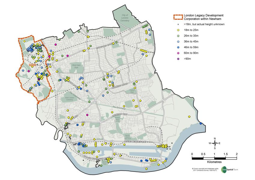
Contents
Introduction .............................................................................................................................. 4
Methodology............................................................................................................................. 4
What is a tall building in Newham? ......................................................................................... 4
Community Neighbourhoods ................................................................................................... 5
Spread of tall buildings in Newham ......................................................................................... 5
PTAL ........................................................................................................................................... 7
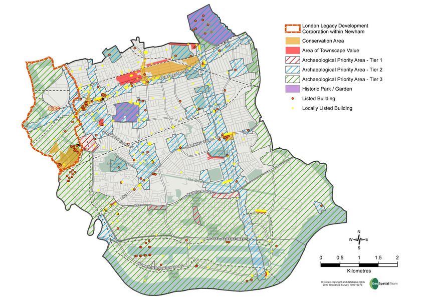
Heritage ..................................................................................................................................... 7
Newham Riverside .................................................................................................................. 10
Royal Docks Neighbourhood .................................................................................................. 12
S09 Silvertown Landing ........................................................................................................... 14
S21 Silvertown Quays .............................................................................................................. 16
S20 Lyle Park West .................................................................................................................. 18
S22 Minoco Wharf ................................................................................................................... 20
S23 Connaught Riverside ......................................................................................................... 22
S04 North Woolwich Gateway ................................................................................................ 24
Beckton Neighbourhood ........................................................................................................ 26
S19 Albert Basin....................................................................................................................... 27
S02 Alpine Way Retail Park ..................................................................................................... 29
S01 Beckton Riverside ............................................................................................................. 31
S31 Royal Albert North ............................................................................................................ 33
Plaistow Neighbourhood ........................................................................................................ 35
S29 Plaistow North .................................................................................................................. 36
Manor Park Neighbourhood................................................................................................... 38
Green Street Neighbourhood ................................................................................................. 39
S27 Queen’s Market ................................................................................................................ 40
Forest Gate Neighbourhood ................................................................................................... 42
S24 Woodgrange West ............................................................................................................ 43
East Ham Neighbourhood ...................................................................................................... 45
S25 East Ham Market .............................................................................................................. 46
S26 East Ham Town Hall Campus ............................................................................................ 48
S03 East Ham Western Gateway ............................................................................................. 50
Stratford and West Ham Neighbourhood .............................................................................. 52
S05 Stratford Central ............................................................................................................... 53
S10 Abbey Mills ....................................................................................................................... 55
S29 Plaistow North: see Plaistow section ............................................................................... 57
2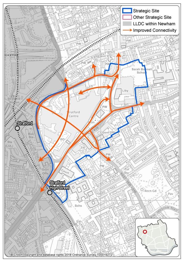
Canning Town and Custom House Neighbourhood............................................................... 58
Canning Town ‘Tallest Building Area’ ...................................................................................... 59
S14 Canning Town Central ...................................................................................................... 62
S12 Canning Town Riverside ................................................................................................... 64
S06 Coolfin North .................................................................................................................... 66
S28 Custom House/Freemasons ............................................................................................. 68
S11 Parcelforce ........................................................................................................................ 70
S30 Royal Victoria West........................................................................................................... 72
S18 Limmo ............................................................................................................................... 74
S16 Silvertown Way East ......................................................................................................... 76
S17 Silvertown Way West ....................................................................................................... 78
S13 Manor Road ...................................................................................................................... 80
S15 Canning Town East ........................................................................................................... 82
S08 Thames Wharf .................................................................................................................. 84

                                                                     3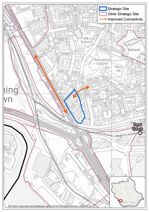
Introduction
1.   This is a study intended to inform the local plan review (LPR) with reference to
     Policy SP4 ‘Tall Buildings’ in the local plan; and forms part of the evidence base
     and Options Appraisal for the review.

2.   The study focuses on establishing appropriate densities and indicative
     appropriate heights for tall buildings at proposed and existing strategic sites in
     Newham and developing further the spatial strategy set out in Policy SP4. The
     study is consistent with London Plan and Historic England advice to identify
     appropriate, sensitive and inappropriate locations for tall buildings as part of an
     urban design framework. In Newham’s case this framework is the Newham
     Character Study which this study extends.

Methodology
3.   For the purposes of this study, the in-principle acceptability of a new tall building
     is established firstly by its location. The current London Plan (2016) states that
     tall buildings should generally be limited to sites in the Central Activity Zone,
     opportunity areas, areas of intensification or town centres that have good access
     to public transport. Secondly, in accordance with both London Plan and Historic
     England advice, a tall building at an appropriate location must not adversely
     affect local character by reason of its scale, mass or bulk. These criteria are
     reflected in the design cues of the Character Study and the existing SP4 spatial
     strategy.

4.   Appropriate building height ranges at locations which accord with the above
     criteria are then derived from the particular characteristics of the individual
     Strategic Site in the context of the characteristics and legibility of each
     community neighbourhood as identified by the Character Study based upon an
     examination of topography, views, heritage, public transport accessibility, and
     character including current tall building presence. Analysis also reflects on
     consultation responses to the Local Plan Review, including advice from Statutory
     Consultees/Duty to Co-operate Partners and developers undertaking more
     detailed masterplanning exercises, as well as drawing on the independent
     advice of the Design Review Panel in relation to planning applications and pre-
     application advice for tall buildings schemes in the area.

5.   Detailed matters of design, appearance, materials, and microclimate are
     reserved for later consideration through the policy although it is worth stating that
     only a superior level of design will be acceptable after the primary criteria of
     location and impact on character including detailed consideration of height and
     density are satisfied.

What is a tall building in Newham?
6.   In the context of Newham, a borough mainly characterised by large areas of low
     rise two- storey housing within a predominantly flat landscape, it is considered
     both necessary and useful to define a tall building. A ‘tall building’ is considered

                                            4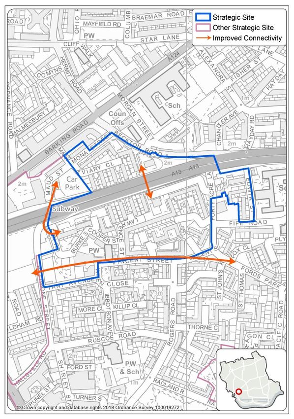
to be: any building of six or more storeys in height equivalent to approximately
     18.6-20.15m in height1

7.   Mid-rise development which is referred to throughout this document falls within
     the category of tall building but typically at its lower end: 6 to 8 storeys.
     Newham’s policy approach is for three categories of tall building: 6 to 8 storeys;
     8 to 19 storeys; and 20 plus storeys. These categories are equivalent to: ‘mid-
     rise tall building’’, ‘tall building’ and ‘very tall building’. As a tall building is now
     defined as 6 or more storeys so ‘mid-rise’ in Newham’s terms is 6 to 8 storeys.

Community Neighbourhoods
8.   The borough is divided into 8‘Community Neighbourhoods’ which are based on
     electoral wards and which provide the structure for community engagement. It
     should be noted that the Character Study amalgamates several of the
     community neighbourhoods to create five areas for the purpose of the study:
     Northern, Southern, South-Western, Lower Lea Valley north of the District Line
     and Lower Lea Valley south of the District Line. Nonetheless, Appendix Two of
     the study sets out a detailed assessment of the character of each of the
     community neighbourhoods. However, the Core Strategy sets out spatial policies
     for 5 areas, broadly aligned with these but separating out Beckton and the Royal
     Docks, plus Urban Newham. For the purposes of this study, the strategic sites
     are examined in the context of 9 neighbourhoods made up of the 8 community
     neighbourhoods but with Beckton and Royal Docks being split into its two
     constituent parts.

Spread of tall buildings in Newham
9.   Of the 8 community neighbourhood areas only three: Stratford and West Ham,
     Custom House and Canning Town, and Royal Docks & Beckton (part) are
     generally characterised by tall buildings. All these neighbourhoods lie within the
     Arc of Opportunity. The Arc of Opportunity stretches from Stratford and the
     Queen Elizabeth Olympic Park, down the Lower Lea Valley and east through the
     Royal Docks to Beckton. The Council’s vision set out in the Local Plan sees
     major development proposals and most growth, employment and residential, in
     Newham as being focused in this area but also promotes its integration with the
     other urban neighbourhoods in the borough.

10. The other five neighbourhoods are generally low-rise in character with tall
    buildings being confined to the sporadic distribution of post-war Council tower
    blocks across the borough, and to contemporary developments in town centres
    and at transport nodes.

1
 This comes from the Council on Tall Buildings and Urban Habitat (Australia). Calculation for
a five storey building: ground floor with entrance lobby 4.65m then four storeys of 3.1m in
height.

                                              5
Tall Buildings (over 18m) in Newham

                                      6
PTAL
11. Public transport accessibility levels (PTALs) as defined by the London Plan 2016
    are a detailed and accurate measure of the accessibility of an area to the public
    transport network, taking into account walk access time and service availability.

12. The borough shows a wide variation in PTAL from a rating of 6b (best) to 0
    (worst). The highest PTAL is to be found in the vicinity of the underground
    stations at Stratford, Canning Town, Plaistow, Upton Park, East Ham and West
    Ham, and the lowest is to be found in the riverside areas of west Beckton.

13. It is likely that there will be changes to PTAL ratings to certain parts of the
    borough. The stations at Manor Park, Forest Gate, Maryland, Custom House
    and Stratford are being upgraded to Crossrail stations with consequent
    improvement in service levels at these established transport nodes.
    Furthermore, there exists the possibility of two new DLR stations at Beckton
    Riverside and Thames Wharf.

14. The implications for the appropriateness of tall buildings in the context of
    possible PTAL improvements are noted in consideration of the strategic sites
    where relevant. The upgrading of Forest Gate and Customs House to Crossrail
    stations along with Stratford, Maryland and Manor Park will make the
    surrounding areas better connected to the wider London region and the national
    transport network. Strategic sites such as Woodgrange Road, Coolfin North and
    Custom House/Freemasons will as a result be more accessible justifying higher
    density development and taller buildings to mark the improved transport node.
    The possibilities for new DLR stations in the borough will benefit the Beckton
    Riverside and Thames Wharf strategic sites. In addition, better connectivity
    across the borough arising from regeneration initiatives and redevelopment of
    the strategic sites as well as development of the bus network may improve PTAL
    further.

Heritage
15. Newham currently has 9 Conservation Areas. With the exception of the East
    Ham conservation area, all the borough’s conservation areas have been the
    subject of a detailed appraisal and had have management plans in place. In
    addition, the Local Plan designates a further 9 Areas of Townscape Value (ATV).
    These are defined as being ‘an area of heritage value, with potential for
    designation as a conservation area, which the Council will than have a duty to
    protect and enhance.

16. Conservation areas in Newham are mainly in the north of the borough, reflecting
    historic development patterns. They contain the best available examples of their
    typologies, and often several listed buildings, structures etc. The list of
    Conservation Areas is as follows:

       Manor Park - Durham Road
       Forest Gate - Woodgrange Estate
       Stratford and West Ham - Three Mills
       Green Street/Forest Gate - Romford Road

                                         7
Forest Gate - Town Centre
       Stratford and West Ham - Stratford St Johns
       Stratford and West Ham/Forest Gate - University
       East Ham - East Ham (civic centre)
       Stratford and West Ham - Sugar House Lane

17. The list of Areas of Townscape Value, which have a greater spread throughout
    the borough and which move into some areas of 20th Century development in
    the centre and south of the borough, is as follows:

       ATV1 Wanstead Flats
       ATV2 Sebert Road
       ATV3 Manor Park
       ATV4 Forest Gate
       ATV5 All Saints Church, Church Street North
       ATV6 Cheltenham Gardens, Henniker Gardens, Rancliffe Road
       ATV7 Canning Town
       ATV8 Winsor Terrace
       ATV9 Bargehouse Road/Woolwich Manor Way

18. There are four Grade 1 statutorily listed buildings in the borough, 5 Grade II*
    buildings, and 110 Grade II buildings. There are also 191 locally listed buildings
    in the borough.

                                          8
Heritage Assets in Newham

                            9
Newham Riverside
19. The Council seeks to ensure a plan-led approach to all new tall buildings in the
    Borough. It is considered that such an approach is particularly important with
    regard to the sweep of strategic sites allocated for development along the north
    bank of the river Thames in this borough.

20. A consistent and reasoned approach to tall buildings at these sites is justified
    given the sites’ unique location along the river.         In addition, they are
    distinguished from many of the other Strategic Sites in Newham by being highly
    visible from outside the Borough not only across the river from the neighbouring
    Borough of Greenwich and the Thames Path but from international sea traffic
    along the river itself. The river in effect forms a key corridor along which the
    Council’s aspirations for high quality development can be emphasised to a wide
    audience.

21. In promoting the legibility of these new riverside areas the managed location and
    height of tall buildings is central to place-making as well as to achieving the
    ultimate success of their development as new residential communities.

22. The Council’s approach is twofold: to indicate acceptable general heights at
    each of the sites as part of a riverside strategy; and, as part of this strategy to
    adopt a spatial direction in respect of tall buildings along the river which will
    promote a hierarchy of place in the borough by stepping away from the tallest
    and busiest areas as one moves from east to west.

23. Recent planning decisions and recommendations from the Design Review Panel
    have indicated that heights of more than 15 storeys (currently the indicative
    height for the riverside strategic sites in the local plan review) can be accepted in
    this area for buildings of exemplary design quality in certain locations subject to
    masterplanning.

24. A focal development plot at the Royal Wharf scheme has been approved at a
    height of 18 storeys on a prominent site on the riverside. This building has in turn
    been recently complemented by approvals for buildings of almost equivalent
    height nearby at Deanston Wharf, and also favourable indications through
    Design Review at a location closer to the DLR station (presently Minoco Wharf
    becoming Lyle Park West). In this context, it is considered that buildings of up to
    18 storeys may be accepted at several of the other Strategic Sites along the
    riverside.

25. On the basis of these considerations, it is judged appropriate that a maximum
    height of 18 storeys is accepted at key locations within the Strategic Sites at S08
    Thames Wharf, S09 Silvertown Landing, S20 Lyle Park West and S22 Minoco
    Wharf. These sites are thus distinguished from the Tall Buildings Policy Area in
    Canning Town where heights of more than 20 storeys are acceptable.

26. In turn, however, the taller elements at key locations will contrast with a general
    height or datum for the same sites of up 10 to 12 storeys. This form is based on
    the success of the Royal Wharf development (S22 Minoco Wharf) which
    provides high density residential accommodation whilst delivering superior
    architectural quality and optimal living conditions.

                                           10
27. The careful master-planning of the development has ensured good daylighting to
all residential units, pleasant outlook to green areas including a new park to
which the Silvertown War Memorial has been relocated and liberal separation
distance between facades. Much of this arises from careful layout of roads and
pedestrian/cycle routes through the development. This scheme is seen as a
good example of place-making and high quality living conditions which can set
the standard for developments of an equivalent or greater value at the other
riverside Strategic Sites.
28. In addition, it is considered appropriate that in the range of Strategic Sites that
run eastward along the borough’s southern boundary on the riverside from SO 8
Thames Wharf to North Woolwich Gateway, there should be a distinctive and
evident trend of building heights reduction/stepping down from the tallest building
zones at Canning Town town centre in Newham and City Island (London
Borough of Tower Hamlets) i.e. with distance increasing from the northern part of
the Isle of Dogs which is regarded as closely related in function to the Central
Activities Zone 2 and from the prospective Major town centre and PTAL 6a
transport hub of Canning Town town centre.
29. The Greenwich Peninsula in the neighbouring Royal London Borough of
Greenwich on the opposite side of the Thames is being developed as a major
focus for high rise, high density development including a range of leisure uses
around the iconic O2 Dome. Whilst the peninsula which is linked to Newham by
the Emirates Air Line cable car also forms part of the context for tall buildings
along the riverside, the Newham Riverside has its own identity and coherence.
30. The lower indicative heights at Connaught Riverside (general height up to 6-8
storeys and up to15 storeys at key locations), North Woolwich Gateway (general
height up to 6-8 storeys and up to15 storeys at key locations) are considered to
reflect the desired drop in building height moving eastwards, as PTAL and
central characteristics decrease, as well as proximity of heritage assets at these
locations.
31. Likewise, Albert Basin (general height up to 6 to 8 storeys with some taller
elements of up to 13 storeys at key locations) and Beckton Riverside (up to 12
and up to 19 storeys at a new town centre/DLR station) which are the Strategic
Sites furthest east along the river reinforce the visual trend for heights to drop
away to the east
32. These strategic sites fall within Royal Docks, Custom House and Canning Town,
and Beckton neighbourhoods in this document; each of the sites is considered
fully in the relevant neighbourhood section as follows.
2
London Plan 2016 para 2.55/draft New London Plan para 2.4.3
11Royal Docks Neighbourhood
Overview of neighbourhood
33. Historically, this was a low-rise area with two to four storeys as the prevalent
height, as well as a scattering of Council tower blocks of between 12-16 storeys
in height.
34. This community neighbourhood has seen very significant changes in its
character since the original Character Study was undertaken in 2011.
35. Major residential developments have been approved on former industrial land
adjoining the Thames which are designed at high density and which incorporate
significant tall buildings. The new developments generally have baseline heights
of 6 to 8 storeys with taller elements of up to 15 storeys at key points. The
presence of the DLR line and stations running in parallel with North Woolwich
Road provides an east to west corridor across this development zone. The
developments are equally focussed on the river to the south. The presence of
these two buffers allows dense development laid out in grid form to be pursued
at the sites with appropriate transitions to surrounding development.
36. At Royal Wharf, an 18 storey building the ‘Marco Polo Building’ on a prominent
point in Bugsbys Reach has been approved which is considered by the Design
Review Panel to be a focal point in the development of the riverside areas, and
which may therefore be viewed as being the tallest appropriate height in this
area.
37. Proximity to London City Airport and associated flight path restrictions on
building height restrain new development over much of the Royal Docks area.
Nevertheless mid rise development interspersed with tall buildings are now
characteristic of new development in this neighbourhood.
Heritage and Character Assets
38. The neighbourhood retains significant reminders of its role from the mid-
nineteenth century onwards as the main docks for the port of London. The three
docks: Royal Victoria Dock, Royal Albert Dock and King George V Dock formed
the largest enclosed dock in the world. Their form and layout are still intact but
much of their associated warehousing and other infrastructure have been lost
partly to war damage and also post-war clearance associated with the decline of
the docks and their replacement by other forms of freight transport.
Nevertheless, significant artefacts which evoke the area’s industrial heritage
remain in the form of statutorily listed buildings at Millennium Mills and Silo D,
the cranes at Royal Victoria Dock and the extensive Tate and Lyle sugar refinery
and syrup factory which remain in operation. There is also a listed Victorian
church St Mark’s Church which now operates as the Brick Lane Music Hall.
39. The neighbourhood is provided with high quality open space at Royal Victoria
Gardens which was laid out in 1890 and at Barrier Park which represents more
contemporary landscaping as well as Lyle Park which dates from the interwar
period. This line of parks supplemented by new riverside walks and amenity
areas at new developments along the riverside frontage are important amenity
resources for the new housing coming forward in the area as well as providing
12buffers between the developments. The parks also provide pedestrian routes
along the riverside which are rare on its north bank.
40. A potential Area of Townscape Value has been identified at Manor Way to the
west of Royal Victoria Gardens
London City Airport
41. The neighbourhood is distinguished by the presence of London City Airport
which places significant restrictions on development, including heights in the
area. All three main airport-related constraints; safeguarding, noise contours
and public safety zones have implications for tall buildings in Royal Docks,
Development proposals above specified heights within set distances of the
airport and all development immediately adjacent to it will require referral to the
Civil Aviation Authority for scrutiny of flight path, visibility and safety implications.
These compulsory aerodrome safeguarding measures will of themselves restrain
building height over a substantial area including much of the Arc of Opportunity
as manifest in typical heights being achieved in present developments..
42. The local plan and the current review have identified a number of strategic sites
in this neighbourhood to which tall buildings are being guided. An indicative
height density guide is justified for each of these sites as follows:
13S09 Silvertown Landing
PTAL
43. This site has a low PTAL of 2, however, it is located within walking distance of
West Silvertown and Royal Victoria DLR stations, and public transport
accessibility will be improved once Thames Wharf DLR station is opened.
Heritage Considerations
44. There are no heritage assets in the immediate vicinity of the site but it should be
noted that the Grade II statutorily listed cranes in Royal Victoria Dock are visible
from this site.
Heights in area
45. Although currently a low-rise industrial location, the area is dominated by nearby
tall buildings. Western Beach apartments immediately adjacent the site is
between 8 and 12 storeys, buildings around Royal Victoria DLR station including
14the Hoola Towers extend up to 24 storeys. On the other side of the river, tall
buildings 25 to 30 storeys high are visible around the O2 Arena and Greenwich
Millennium Village. Further to the west, a major development has been
accepted at Silvertown Quays in outline form for heights of up to 16 storeys with
the support of the Design Review Panel.
46. In addition, the site is influenced by the same trends of high density development
including tall buildings at other riverside sites to the east.
Views and Topography
47. The considerations set out in respect of Connaught Riverside above also apply
to this site.
Representations
48. At Regulation 18 consultation stage, representations were received in respect of
this site arguing that tall buildings above 12 storeys could be accepted at this
location where constraints allow. The special characteristics of this site and
precedents in the area suggest that buildings of up to 15 storeys may be
accepted subject to master-planning.
Conclusion
49. An overall datum of 10 to 12 storeys is considered appropriate at the westward
riverside Strategic Sites in Newham in line with current trends as per the
discussion above, with a maximum of 18 storeys at key locations. The indicative
heights for this site supports place-making in the borough by promoting a
cohesive range of heights within the Arc of Opportunity.
Deviation from Issues and Options recommendation:
50. Yes. The Issues and Options document indicated 12 storeys as the maximum
height for this strategic site, however, in the unified approach being adopted for
all the riverside strategic sites it is considered that 18 storeys can be accepted at
key locations within the site. With regard to the representations received,
heights are indicative, based on the initial screening and SP4 spatial strategy,
and variation from them would be through the detailed design process in line
with SP4.
15S21 Silvertown Quays
PTAL
51. This site has a low PTAL of 2, however, Pontoon DLR station adjoins the site to
the south and West Silvertown and London City Airport DLR stations are within
walking distance, and development of this site should result in improved
connections to the Customhouse Crossrail station via a new bridge over the
dock.
Heritage Considerations
52. There are two heritage assets within the site: the locally listed Millennium Mills
and the Grade II listed Silo D. In addition, the Grade II listed cranes on Royal
Victoria Dock are prominent n the outlook from this site.
16Heights in area
53. Millennium Mills is 11 storeys in height and Silo D at its highest point is
approximately 9 storeys. To the west Britannia Village encompasses a range of
height including 6 storey high apartment blocks and a 12 storey block at the
dockside. A major development has been approved at Silvertown Quays in
outline for heights of up to 16 storeys at the southern and western perimeters
fronting North Woolwich Road and Mill Road.. To the south on the other side of
North Woolwich Road, Royal Wharf is being developed with heights of between
10 and 18 storeys. To the west and prominent in the outlook from the site are
buildings around Royal Victoria DLR station including the Hoola Towers
extending up to 24 storeys. Immediately to the north on the opposite side of the
dock is the massive Excel complex equivalent to at least 8 storeys in height.
Views and Topography
54. The location of the site on the south bank of Royal Victoria Dock means that tall
buildings in this location will be prominent in views across the dock. It is
important that new development in the Royal Docks is laid out in a cohesive and
well-planned way with a co-ordinated range of heights. This site is also required
to harmonise with the major developments currently under construction along the
river. The site is flat and low lying with no topographical features.
Representations
55. At Regulation 18 consultation stage, no specific representations were received in
respect of this site.
Conclusion
56. It is noted with regard to the riverside development sites immediately to the
south that a general baseline height of 10-12 storeys with heights of up to 18
storeys at key locations is generally acceptable. This site although it forms part
of the arc of Strategic Sites running between the Royal Docks and the river is
north of North Woolwich Road and fronts on to the Royal Victoria Dock rather
than the river. Royal Victoria Dock is already characterised by tall buildings as
well as the high cranes which are statutorily listed. The site itself has been
approved in outline with a range of 16 storey buildings. Against this background
of tall building precedents in all the surrounding area it is considered that mid-
rise development of 6 to 8 storeys is appropriate with components of up to 16
storeys at key locations. The indicative height for this site supports place-
making in the borough by promoting a cohesive range of heights within the Arc
of Opportunity.
Deviation from Issues and Options recommendation:
57. Yes. The Issues and Options document indicated 12 storeys as the maximum
height for this strategic site. However it is considered that 16 storeys can be
accepted at key locations within the site without undermining the unified riverside
approach to tall buildings.
17S20 Lyle Park West
PTAL
58. This site has a relatively low PTAL score of just 2 and 3. However, it should be
noted that the site directly adjoins West Silvertown DLR station,
Heritage Considerations
59. Lyle Park which lies to the east of this site is an important area of public open
space. The original entrance gates to the Harland and Wolff shipyards in North
Woolwich which closed in 1972 were re-erected in Lyle Park and are locally
listed. No other heritage assets are present in the area.
Heights in area
60. On the west side, the site is adjoined by generally low-rise industrial
development with some taller elements of up to around 6 storeys which this
review of the Local Plan intends to retain.
1861. Beyond Lyle Park lies the intensively developed Royal Wharf neighbourhood
which incorporates a complex of tall buildings including the 18 storeys Marco
Polo landmark building at the river edge which should be regarded as the pivot
for all development along Newham river bank.
62. Within this site itself a 12 storey scheme has been approved at 1 Knights Road.
The Design Review Panel considered this height to be appropriate successful
both in terms of architectural composition and townscape. It should also be
noted that a 15 storey development has been approved at Pontoon Dock DLR
station.
Views and Topography
63. The considerations set out in respect of Connaught Riverside above also apply
to this site.
Representations
A representation was received at Reg 18 consultation stage which identified the
building height as too inflexible and limiting the amount of open space that can be
procured at this site.
Conclusion
64. In the context of trends in this area and the coherent approach to Rviersdie tall
buildings set out above, high density development is considered to be
acceptable with a datum of 10 to 12 storeys and 18 storeys at key locations
subject to master-planning which takes account of the Lyle Park open space and
low-level industrial land which it adjoins and the DLR station. The indicative
height for this site supports place-making in the borough by promoting a
cohesive range of heights within the Arc of Opportunity and along the riverside..
Deviation from Issues and Options recommendation:
65. The datum levels are now increased to 10 to 12 storeys (from 6 to 8 storeys in
the Issues and Options: Strategic Sites document) in line with nearby Strategic
Sites and the coherent riverside approach to tall buildings described above.
With regards to the representation received, heights are indicative, based on the
initial screening and SP4 spatial strategy, and variation from them would be
through the detailed design process in line with SP4.
19S22 Minoco Wharf
PTAL
66. This site has a relatively low PTAL score of just 2, however, the site is within
walking distance of the DLR stations at West Silvertown and Pontoon Dock and
likely new bridge access over Royal Victoria Dock to Custom House Crossrail
station. It is also within a possible Crossrail intensification area focussed on a
potential new station at City Airport.
Heritage Considerations
67. Lyle Park which lies to the west of this site is an important area of public open
space and was originally laid out in 1924. The original entrance gates to the
Harland and Wolff shipyards in North Woolwich which closed in 1972 were re-
erected in Lyle Park and are a locally listed building. No other heritage assets
are nearby.
20Heights in area
68. The majority of this site is currently being developed as Royal Wharf a major
development with heights of between 10 and 18 storeys. The site's eastern
section known as Deanston Wharf which directly adjoins the public open space
at Lyle Park is being developed separately. A proposal for four building plots of
between 9 and 17 storeys in height at this location was recently approved in
December 2017.
Views and Topography
69. The considerations set out in respect of Connaught Riverside above also apply
to this site.
Representations
70. Representations received as part of the local plan review in respect of this site
sought a height of more than 8 storeys at Deanston Wharf and set out the
regeneration benefits arising from carefully considered development of tall
buildings in line with London Plan policy.
Conclusion
71. The development of the remainder of this Strategic Site in the Deanston Wharf
division will be required to harmonise with the masterplan for Royal Wharf and
also to relate satisfactorily to the adjacent open space at Lyle Park. In particular
this development is required to harmonise with the 18 storey tower at Royal
Wharf which has been identified as a focal point by the Design Review Panel for
the area.
72. An overall baseline height of 10 to 12 storeys is considered appropriate at the
westward riverside strategic sites closest to the taller buildings area at Canning
Town and City Island in line with current trends. The site already includes the
approved Marco Polo Building (18 storeys) which stands at a prominent curve in
the river on Bugsbys Reach as the dominant building in the area the setting of
which is required to be enhanced by other new developments. This height
should therefore be regarded as the maximum for the area. The indicative
height for this site supports place-making in the borough by promoting a
cohesive range of heights within the Arc of Opportunity and along the riverside.
Deviation from Issues and Options recommendation:
73. An upper limit of 19 storeys had been indicated in the Issues and Options
however this should be reduced in line with the approved Marco Polo building
which occupies a pivotal location within Royal Wharf development at this
allocation. A general maximum of 18 storeys is appropriate for westwards
riverside development proposals to facilitate a stepping down from the tall
buildings area at Canning Town and City Island. With regard to the
representation received, heights are indicative, based on the initial screening
and SP4 spatial strategy, and variation from them would be through the detailed
design process in line with SP4.
21S23 Connaught Riverside
PTAL
74. This site has a relatively low PTAL score of just 2. However, it is noted that the
site lies within walking distance of the DLR stations at City Airport and Pontoon
Dock and growth-related infrastructure requirements will include access
enhancements. There remains the possibility of a Crossrail station at City
Airport which may raise the PTAL rating, as well as improvements to bus
services and bridging of various barriers.
Heritage Considerations
75. The site incorporates Brick Lane Music Hall (the former St Mark’s Church) a
grade II listed building. No other heritage assets are present in the immediate
area. The setting of the church which is a unique feature in the area will require
careful treatment in relation to the placement and height of buildings on the site.
22Heights in area
76. Buildings of 12 storeys in height are already present adjacent to this allocation
on the west side of Thames Road and Wards Wharf Approach and there has
been a recent planning permission for a 13 storey development at Royal Docks
Station within the allocation itself. The prevailing character of this allocation
south of North Woolwich Road is for tall buildings. By contrast north of North
Woolwich Road buildings including the listed church referred to above are
generally low although the Travel Lodge hotel is 6 storeys in height.
Views and Topography
77. The location of the site on the riverfront means that tall buildings in this location
will be prominent in views of the north bank of the Thames. It is important that
new development on Newham’s riverside is laid out in a cohesive and well-
planned way with a co-ordinated range of heights. All the more so when
enhanced pedestrian and cycle routes and promenades are being developed on
the south bank of the river giving unbroken and direct views across the river to
Newham. There are also opportunities for views to the Royal Docks notably
from Silvertown Quays but this and other riverside sites can avail of vistas and
linkages in the blue ribbon network.
78. Views of the river from highways and public areas are currently obstructed by
existing development. Careful layout of new development will afford
opportunities to open up views of the river, and the south bank of the allocation
affords the potential for a riverside path which in time can integrated with other
sections at similar development sites along the river.
Representations:
79. A representation was received at Reg 18 consultation stage which identified the
building height as too inflexible and limiting the amount of dual aspect dwellings
and open space that can be procured at this site.
Conclusion
80. An overall datum of 6 to 8 storeys is considered appropriate at this riverside
strategic site in Newham in line with current trends. The Design Review Panel
has indicated in its assessment of proposals at a number of the riverside sites
that heights of up to 15 storeys can be accepted at key locations (as at Pontoon
Dock station).
81. However, the area north of North Woolwich Road requires a more low key and
sensitive approach. Mid-rise development would be acceptable here with an
emphasis on improving the area around the Grade II listed Brick Lane Music
Hall. The indicative heights for this site support place-making in the borough by
promoting a cohesive range of heights within the Arc of Opportunity.
Deviation from Issues and Options recommendation:
82. A maximum height of 12 storeys was put forward at Issues & Options, however,
in reviewing and devising a coherent approach to all the riverside strategic sites
in line with Design Review Panel advice greater heights may be acceptable.
23S04 North Woolwich Gateway
PTAL
83. This site has a PTAL of just 2 but the location is within walking distance of King
George V DLR station, and connects with the major transport hub of Woolwich
on the other side of the river by ferry, foot tunnel, and DLR.
Heritage Considerations
84. This site marks an important crossing of the Thames with historical associations
dating back to Roman times. The foot tunnel entrance and station itself are
Grade II listed buildings. The allocation adjoins Royal Victoria Gardens, a large
park originally laid out in 1898; at the eastern end of which is an Area of
Townscape Value which may be elevated to a conservation area at some future
point.
24Heights in Area
85. The North Woolwich area is distinguished by three 1960’s tower blocks to the
north of Albert Road: Westland House, Dunedin House and Queensland House.
As these pre-date the Local Plan they can be discounted as precedents. There
are several other blocks in the area of 8 and 9 storeys in the same area to the
north. Within the site itself there are substantial blocks of 5 storeys built and
operated by housing associations. There is currently also a proposal for a major
development at Store Road on the west side where the height at 15 storeys has
been accepted as being appropriate to the area.
Views and Topography
86. The considerations set out in respect of Connaught Riverside above also apply
to this site.
Representations
87. No representations were received in respect of heights at this site at Reg 18
stage.
Conclusion
88. A general baseline height of 6 to 8 storeys is considered appropriate at riverside
strategic sites moving away from the tallest buildings areas at Canning Town
and City Island in Newham/Tower Hamlets in line with current trends. The
Design Review Panel has indicated in its assessment of proposals at a number
of the riverside sites that heights of up to 15 storeys can be accepted at key
locations. The indicative height for this site supports place-making in the
borough by promoting a cohesive range of heights within the Arc of Opportunity.
89. The Woolwich ferry marks an ancient crossing of the Thames, the significance of
which is underscored by the Grade II listed foot tunnel and station. Any
development must place the special character of this area at the centre of its
rationale.
Deviation from Issues and Options recommendation:
90. The Issues and Options document indicated a maximum height of 18 storeys at
the Royal Pavilion site. In the context of the overall development of Newham’s
riverside sites this may be excessive. Given the coherent approach to riverside
sites set out above, which justifies a general stepping down from the tallest
buildings area to the west a general cap of 15 storeys is appropriate at this site.
This site is a gateway to the borough where a tall building could be viewed as
appropriate. However, the site has a relatively low PTAL and is separated from
the local centre. A landmark building need not be a tall building and the
suggested limit of 15 storeys offers sufficient scope for noteworthy architecture.
The presence of the three tower blocks to the north of Albert Road are not
considered to set a precedent at this location south of the Albert Road spine and
in the line of riverside development sites.
25Beckton Neighbourhood
91. Prevailing heights across this neighbourhood area are generally those of low-rise
residential development much of it modern housing estates laid out in the 1980’s
with extensive landscaping schemes which have now matured.
92. However, there is an emerging cluster of taller buildings south of Royal Albert
Way/Atlantis Avenue. These include the University of East London and Newham
Dockside which are up to 7 storeys in height. Great Eastern Quays has recently
been constructed at 13 storeys and the ABP development currently under
construction will be up to 14 storeys. Otherwise, tall buildings are generally
absent except for long views towards towers on the skyline at Ilford to the north
and Canary Wharf to the east as well as Stratford.
93. Nevertheless, the local plan and the current review have identified a number of
Strategic Sites in this neighbourhood to which tall buildings could be guided:
26S19 Albert Basin
PTAL
94. This site has a low PTAL rating of 2 with Gallions Reach DLR station and bus
routes to Gallions Reach shopping park operating some distance to the north of
this allocation.
Heritage considerations
95. Gallions Hotel a Grade II listed building is nearby, as also is the locally listed Sir
Steve Redgrave Bridge and the locally listed tidal pumping station designed by
Richard Rogers. None of these identified assets would be affected by
development at this site.
27Heights in the area
96. This allocation has been the focus of intense, high density development which
incorporates tall buildings. Great Eastern Quays has been developed as a mid-
rise scheme but incorporating a tower of 13 storeys. Atlantis Avenue has been
developed with 5, 8. and 12 storey towers, and there have been further outline
permissions in the area for heights of up to 12 storeys. It should be noted that
proximity to City Airport restrains height in this area.
Views and Topography
97. Careful layout of new development will afford opportunities to open up views of
the river, and affords the potential for a riverside path which in time can
integrated with other sections at similar development sites along the river.
Representations
98. No representations were received in respect of this site in Reg 18 consultation
on the local plan review.
Conclusions
99. It is considered appropriate that the remaining plots within this allocation are
taken forward at similar densities and heights to the developments already
approved. Hence high density schemes of mainly mid-rise form 6 to 8 storeys
with some tall building elements of up to 13 storeys are considered to be
appropriate. Taller buildings exceeding these guidelines would jar with the
uniformity of approach to the several sites that make up this allocation, and in
any case would probably be prohibited by aviation concerns. The indicative
height for this site supports place-making in the borough by promoting a
cohesive range of heights within the Arc of Opportunity
Deviation from Issues and Options recommendation
100. No.
28S02 Alpine Way Retail Park
PTAL
101. This allocation has a relatively low PTAL score of 3 although Beckton DLR
station and its associated bus interchange is within walking distance and
connections can be improved through master planning
Heights in the area
102. Tall buildings are not present in this area which is characterised by low-rise
housing. The tallest building is the Premier Inn which is 3 storeys in height.
29Heritage considerations
103. There are no identified heritage assets in the immediate vicinity of the site
though Winsor Terrace Area of Townscape Value lies 200 metres to the south
east (low rise gas workers’ cottages). St Mary Magdalene’s a Grade I listed
medieval church lies some distance to the north on the other side of the A13.
Representations
104. No representations were received in respect of this site in Reg 18 consultation
on the local plan review.
Views and Topography
105. Beckton Alp lies immediately to the north.
Conclusions
106. The site has the potential to transition between the nearby Beckton town centre
with a mid-rise development of medium density, in character with the
surrounding neighbourhood. Taller buildings of more than 8 storeys are not
considered appropriate at this suburban location. Interest could be lent to the
site’s development by maximising views of the nearby Beckton Alp. Such an
approach supports the hierarchy of places in the borough by keeping to an
appropriate height within Urban Newham outside a town centre.
Deviation from Issues and Options recommendation
107. No
30S01 Beckton Riverside
PTAL
108. This is an extensive allocation which currently comprises open land which
contains important infrastructure at Beckton sewage works and the DLR
compound as well as Gallions Reach Retail Park and some recently completed
major housing developments.
109. PTAL rates across the allocation are low and do not rise above 2 as the highest
rating. It is possible that a new DLR station may open in the future within this
allocation as part of extensions and service enhancements to meet growth
needs in the area. .
Heritage considerations
110. There are no heritage assets present within this allocation. The nearest are
Gallions Hotel a Grade II listed building, the locally listed Sir Steve Redgrave
Bridge and the locally listed tidal pumping station designed by Richard Rodgers
but all are too far away to be affected by development at this location.
31Heights in the area
111. Development within this allocation is currently low level. In the area
immediately to the south, Great Eastern Quays has been developed as a mid-
rise scheme but incorporating a tower of 13 storeys. Atlantis Avenue has been
developed with five, eight and 12 storey towers, and there have been further
outline permissions in the area for heights of up to 12 storeys.
.
Topography and Views
112. The site comprises flat former marshland adjoining the Thames which has
been sporadically developed with a variety of land uses. The open nature of
the site gives distant views of high rise development in the Royal Docks and
Canning Town which can be utilised in the layout of forthcoming development.
113. Careful layout of new development will afford opportunities to open up views of
the river, and affords the potential for a riverside path which in time can
integrated with other sections at similar development sites along the river.
Representations
114. A representation from a landowner received as part of the Reg 18 consultation
in the local plan review suggested that future PTAL improvements be taken into
account in assessing heights for tall buildings and that suitable heights should
be arrived at on the basis of careful consideration of context, character, PTAL
and quality of place-making. The points raised are reflected in this assessment
of the allocation.
Conclusion
115. A series of neighbourhoods is seen as emerging in this area as well as the
upgrading of Gallions Reach shopping park to a Major town centre. The trends
set by new development at Albert Basin immediately to the south may be
extended to this allocation. Medium to high density development is therefore to
be expected with a strong emphasis on family housing. Heights are expected
to be mid-rise at 5 to 8 storeys and lower in accordance with the provision of
family-sized accommodation. There should be opportunities for taller buildings
of up to 12 storeys at key locations.
116. There may be scope for taller buildings of up to 19 storeys in association with a
new town centre & DLR station. These ‘central’ buildings would then provide a
focus for the wider development of the allocation. The indicative heights for
this site supports place-making in the borough by promoting a cohesive range
of heights within the Arc of Opportunity which may be considered to sweep
upwards to include this site.
Deviation from Issues and Options recommendation:
117. No. With regard to the representation received, heights are indicative, based on
the initial screening and SP4 spatial strategy, and variation from them would be
through the detailed design process in line with SP4.
32S31 Royal Albert North
PTAL
118. This site has a PTAL rating of 2, however, it should be noted that Royal Albert
and Beckton Park DLR stations are within walking distance of the site.
Heritage considerations
119. The site contains two Grade II listed buildings at the Dock Manger’s Office and
Central Buffet both of which are vacant while the locally listed Compressor
House (built in 1914) is located to the west of the site. All are substantial
buildings of 2 to 3 storeys in height.
Heights in the area
120. The surrounding area north of Royal Albert Dock is not distinguished by any tall
buildings. The site is adjoined to the east by the University of East London
which comprises a complex of six storey building. Beyond the university the
33strategic site at Albert Basin is being developed with buildings of up to 12
storeys in height. To the south of Royal Albert Dock is London City Airport
which is open and low rise. While to the north lie the extensive low rise
housing estates of Beckton.
121. The site itself is being developed as a major business park and residential
neighbourhood. Detailed planning permission has been granted for buildings
of up to 12 storeys while the master plan envisages future development of 14
storeys. A joint meeting of the Design Review Panel and CABE did not raise
any objection to these heights which was focussed on the detailed part of the
masterplan.
Topography and Views
122. The area is flat in without any topographical features of note. The DLR runs to
the north along the route of Royal Albert Way. The railway is elevated at this
section and gives views onto this site.
Representations
123. No representation was received in response to Reg 18 consultation in the local
plan review.
Conclusion
124. Development has been approved at the site for heights of 12 storeys in a
generally low-rise area. The master plan allows further development of up to
14 storeys. It is considered that future development should keep the character
already set by fully permitted parts of the masterplan at general mid-rise
baseline of 6 to 8 storeys with tall buildings of up to 14 storeys at key locations.
It should be noted that this site south of Royal Albert Way marks the northern
extent of the strategic sites in the Arc of Opportunity with low rise housing in
Urban Newham extending north of the dual carriageway. The indicative height
for this site supports place-making in the borough by promoting a cohesive
range of heights within the Arc of Opportunity.
Deviation from Issues and Options recommendation:
125. No
34Plaistow Neighbourhood
126. The overall character of Plaistow is that of a low rise late nineteenth century
suburb with general building heights of two to four storeys. There is some
limited taller post-war development in local authority housing estates of
between three and six storeys or scattered tower blocks of 10-17 storeys.
There is also a cluster of mid-rise modern buildings on the High Street.
Heritage considerations
127. The neighbourhood has a number of significant heritage assets such as the
Grade II listed Earl of Derby public house, St Andrews church and Vicarage,
and the Coach and Horses public house.
Representations
128. No representations were received at Reg 18 consultation stage with respect to
tall building issues in this neighbourhood.
Strategic Sites
129. The local plan and the current review have identified only one strategic site in
this neighbourhood to which tall buildings could be guided given the low rise
nature of the area and the absence of any convincing precedents. The majority
of this Strategic Site actually lies within Stratford and West Ham Community
Neighbourhood but is included under the Plaistow neighbourhood to avoid
confusion.
35You can also read