Adopted Amendment to the Carrigaline Electoral Area Local Area Plan 2011 Amendment No. 4 Shannonpark X-01 Incorporating the Shannonpark Framework ...
←
→
Page content transcription
If your browser does not render page correctly, please read the page content below
Adopted Amendment to the Carrigaline Electoral Area Local Area Plan 2011
                   Amendment No. 4 Shannonpark X-01
   (Incorporating the Shannonpark Framework Masterplan Study 2015)

                                                                           1
bypass to the town and consideration will be given to identifying a
1 Carrigaline suitable route during the life time of this plan. In addition, the town will
Table 1.1: Population and Households Carrigaline 2002 -2020
link into the proposed Lower Harbour Sewerage scheme, and future
Carrigaline 2002 2006 2020 Growth
water supply will be provided from the Cork Harbour and City scheme.
1.1 VISION & CONTEXT census census Target 2006 -2020
Consideration will also be given to achieving the town’s potential as a
district employment centre.
Population 11,191 12,835 14,066 1,231
The strategic aim for Carrigaline is to consolidate the rapid 1.1.6. Local Context
growth of recent years broadly within the town’s existing Households* 3,508 4,264 5,855 1,591
development boundary, protecting its important green belt setting 1.1.7. Carrigaline is situated 13 km south of Cork City and is
while maintaining its distinctiveness as a self contained separated from the city suburbs by open green belt. Carrigaline has a *Estimate
Metropolitan Town with improvement of the town centre and the distinctive identity as a thriving Metropolitan Town with a strong village Housing
town’s residential amenities. character, unique setting, history and community spirit. It is located at
1.2.2. This increase in households gives rise to the requirement for an
the mouth of the Owenboy River and at the Head of the Owenboy
STRATEGIC CONTEXT additional 2,068 housing units to be accommodated in the town as set
Estuary which forms part of Cork Harbour. The estuary itself is of
considerable scenic beauty and is designated part of an extensive area out in table 1.2 below. The need for these additional units arises due to
1.1.1. Carrigaline is a Metropolitan Town within the County the revised population targets as set out in CASP Update, but also due
of scenic landscape and much of it is a proposed Natural Heritage Area.
Metropolitan Strategic Planning Area and has experienced a significant to a changing perspective on vacancy and revised assumptions on
The landscape is dominated by the River and Estuary and gently rolling
amount of development in recent years. The objective for Carrigaline is hills to the North and South of the Town. household size.
set out in SET 2-7 of the County Development Plan 2009 where the 1.2.3. The 2008 Housing Land Availability Study (HLAS) indicates that
1.1.8. To the west of the town, the flood plain, of the Owenboy River
stated aim is to consolidate the rapid growth of recent years broadly the existing residential land supply in the town can adequately
and the steep hills that form its valley, limit the potential for expansion.
within the town’s existing development boundary, protecting the accommodate 3,304 dwellings which includes the Masterplan Area at
The area to the south of Carrigaline is ultimately constrained by steep
important Green Belt areas. Shannonpark. It can be concluded that as the 2020 requirement is
hills forming the valley side.
1.1.2. The CASP Update 2008 envisages moderate population growth 2,068, there is a sufficient supply of zoned land in Carrigaline up to
1.1.9. The location of the settlement in the heart of the Metropolitan 2020.
for Carrigaline. It states that the focus will be upon the consolidation of
Area has made Carrigaline an important residential alternative to Cork
the town centre, with additional retail/services/commercial and
City and its Environs most notably Douglas. The towns setting adjacent Table 1.2: Household and Dwelling requirement for Carrigaline
residential uses, taking into account the flooding issues in the town, the
to Cork Harbour and a designated scenic landscape provide excellent 2020
high amenity and environmental value along the Owenabue (Owenboy)
opportunities to create a high quality living environment.
River corridor, as well as the provision of substantial soft infrastructure Settlement Population H/holds Dwelling Units Growth
to support the town’s population, including recreational and amenity 1.1.10. Housing in recent years has been provided in the form of large Growth growth 2006 -2020
areas and the provision of additional educational facilities on existing housing estate developments which, while often suburban in character, 2006-2020 2006-
primary and secondary school sites. have introduced diversity to the housing mix in the town, catering for all 2020
age groups and stages in the lifecycle. This enhanced choice in
1.1.3. The ability of the town to provide a strong supply of housing and
housing is particularly important for a rapidly expanding settlement like Carrigaline 1,231 1,591 2,068
business land in a location close to the City suggests that Carrigaline
Carrigaline, where the need to maintain mixed communities is an
has potential to play a significant future role in the development of
essential element in maturing a neighbourhood and creating a sense of
Metropolitan Cork. Because of this potential, the DoEHLG have * Figure taken from the Housing Land Availability Study 2008
integration between the established and new communities.
designated Carrigaline as a ’Developing Area’. It is anticipated that the
1.2.4. The majority of new development has been concentrated on
town will receive a degree of priority for future infrastructure investment
both the northern and southern sides of the town at Dun Eoin, Herons
as a result of this designation. 1.2 PLANNING CONSIDERATIONS
Wood, Ballea Road, Castle Heights and Forrest Hill. Development has
1.1.4. A key objective for the Carrigaline Local Area Plan will be to Population & Housing generally taken the form of large estate development dominated by
encourage the development of the Shannonpark Framework semi-detached, terraced town houses, duplexes and some large
Masterplan Area Study. This mixed use site is located on the northern 1.2.1. The population of Carrigaline has grown moderately over the detached style housing. The last decade has seen the addition of over
periphery of the town and will include phased development for up to last decade. Table 1.1 below outlines the principle demographic figures 2,500 units to the housing stock, an increase of 95%.
1,200 1,000 residential units, a ‘Park and Share’ facility, recreation and for Carrigaline town for the last two census years 2002 and 2006. The
amenity areas including integrated sporting facilities, a primary school population of Carrigaline rose by almost 15% in the period 2002-2006
Table 1.3 Carrigaline Housing Stock
and a neighbourhood centre development which will include an office while households grew by 21.5% reflecting the natural trend towards
and retail component. smaller average household sizes. The target growth for population in
2020 for Carrigaline is 14,066 which is an increase of 9.6% while the Settlement Dwgs Dwgs Dwgs 2010 Growth 2001-
1.1.5. In terms of hard infrastructure, the transportation plan prepared Household target for 2020 is 5,855 which is an increase of 37%. 2001 2005 2010.
for Carrigaline focuses on the importance of the delivery of the relief
road to the west of the town, required in order to alleviate some of the Carrigaline 2,695 4,786 5,267 2,572
current traffic congestion within the town and also improvement to the
public transport infrastructure in the town. The Carrigaline Source: Geodirectory
Transportation Plan has also identified a requirement for a western
31.2.5. There is currently an estimated 5,267 units occupied within the Ringaskiddy have also provided a significant amount of employment for Retail
town with a further 26 units under construction. Currently it is estimated Carrigaline.
1.2.6. Retail Strategy 2007 designates Carrigaline as a Metropolitan
that newly built vacancy’s stand at 70 units (when considering
1.2.2. The CASP Update combined Carrigaline and Ringaskiddy into a Town which in retail terms has the potential to expand in line with the
Carrigaline’s metropolitan location this vacancy level could be
single employment area. Table 1.5 below outlines the 2020 job target for planned population increase for the settlement. The Cork Country
considered moderate). There are outstanding planning permissions for
Ringaskiddy and Carrigaline which were set out in both the CASP Development Plan 2009 acknowledges the importance of Carrigaline in
653 units. It can be concluded that the potential housing stock based on
Update and the Cork County Development Plan 2009. The future jobs providing a wide range of both convenience and comparison shopping
current commitments for Carrigaline stands at 6,016.
requirement for 2020 is 10,316 which is an increase of 2,500 jobs or in locations close to significant centres of population. In 2007 the town
1.2.6. Table 1.4 below outlines that when houses constructed between 32%. contained 5,075sqm of comparison shopping floorspace and 4,350sqm
2006 - 2010 and the number of existing planning permissions are taken of convenience shopping floorspace.
1.2.3. In 2003 there were 35 hectares (ha) of land zoned for business
into account the net requirement of new housing in Carrigaline is 934
use in Carrigaline and by 2008 22ha of this remained undeveloped. 1.2.7. The town has already a wide range of retail facilities including
units.
Carrigaline continues to have a healthy supply of business land located one shopping centre, three large convenience stores (Super Value,
on the Crosshaven Road. As a result of its harbour location and its easy Dunnes store and Lidl), a co-operative store, a hotel, a number of
access (by private car) to Cork Airport, Carrigaline is an attractive pharmacies and a relatively wide range of other comparison shops. The
destination for business. town also has a wide range of services including a Garda station, a fire
Table 1.4 Carrigaline Housing requirement to 2020
station, two churches, doctor surgeries, dentist surgeries, four banks
and a library.
Settlement New Already Outstanding Additional Table1.5: Carrigaline Employment 2006- 2020
Community Facilities and Infrastructure
House Built Required
Planning
Const. 2006- to 2020 Settlement 2020 Growth Land Land Community Facilities
Target 2010* Permissions Jobs needed supply supply
1.2.8. The town has a very strong sense of identity which places the
to 2020 by 2020 2003 2008
community at its heart. The community association is extremely active
(Hectares) (Hectares)
running many community initiatives such as the tidy towns, the
Carrigaline 2,068 481** 653 934 Carrigaline youth club, the community complex and the upkeep of the
Ringaskiddy &
community park.
Carrigaline
* Already built 2006-2010: this is the geodirectory count for 2010 minus the geodirectory
(Strategic 10,316* 2,500* 35 22 1.2.9. The community park is located on the eastern side of the town
count for 2005 and indicates what has been built and occupied between '05 and '10. A fifth
* Employment and is ideally located at the Head of the Owenabue Estuary. This public
of this figure gives a yearly average and four fifths gives an estimate of what was built and
Centre) facility includes a playground for children of all ages including a
occupied between '06 and '10.
basketball court/ 5-aside soccer for teenagers, the community complex
**This Figure includes vacant new units and units under construction. Ringaskiddy & Carrigaline are combined into a single Employment Area by the CASP (which has plans for redevelopmet), the Naionra community pre-school
Update, July 2008.
1.2.7. Given the apparent excess of zoned land when compared to the and the park itself.
likely demand for new housing, this Plan will primarily focus upon the 1.2.4. The average rate of development between 2003 and 2008 was
1.2.10. The town boasts excellent education facilities with five primary
development of existing zoned sites and the phased development of the 2.4 ha per annum, and if this rate were to continue then the town has
schools which include Carrigaline Educate Together National School,
Masterplan site at Shannonpark. Any medium term development will approximately a 9 year supply of business land. While it may be unlikely
Gaelscoil Carraig Ui Leighinn, St. Mary’s Church of Ireland School, St.
have to take account of the existing infrastructure difficulties facing in the current economic climate that the existing take-up rates of
John’s girls national school and Scoile Mhuire Lourdes boys national
Carrigaline and temporary measures will have to be put in place to deal business land will continue, it is considered appropriate to provide for a
school. The town also has a very successful co-educational secondary
with waste water treatment prior to the commencement of any new modest strengthening of the business land supply to ensure there is no
school. It should be noted that due to the town’s large population new
development. shortfall in the life of the plan. This could take the form of re-examining
educational facilities will be required as there is very little room for the
the existing zoned lands or the modest addition of new Greenfield sites
current facilities to expand.
and the draft plan will need to outline the most appropriate approach for
Employment& Economic Activity the town. 1.2.11. Carrigaline has upwards of fifty clubs and societies which cater
for all walks of life. The hurling and football club which was founded in
1.2.1. In the past, agriculture, pottery and food processing were the 1.2.5. The 2006 census indicates that Carrigaline experiences strong
1889 has recently expanded, with new pitches and club house, while
main sources of employment in Carrigaline. In recent years, industrial commuting to Ringaskiddy and Cork City. This is not surprising as Cork
Carrigaline Soccer club have a new facility on the Ballea Road with
development has become the main employment activity in Carrigaline. City is the main employment centre in the County and Ringaskiddy is
pitches and a Clubhouse. Both the GAA club and the Carrigaline Soccer
The principle area for industry and enterprise development is to the identified as a Strategic Employment Centre. As one of the highest
Club cater for over 300 young people over the ages of six. Other notable
south-east of the town. In the 1970's, Biocon (now Quest) established a travel to work routes (Carrigaline to Cork and Ringaskiddy), more
clubs and societies are rugby, basketball, tennis, gymnastics and the
local Biochemical Industry at Crosshaven Road. KiInaglery Industrial attention will have to be given to the provision of infrastructure,
Lions club.
Park and Carrigaline Industrial Park both situated on the Crosshaven especially in peak hours.
road incorporate many large companies such as Pepsi and locally 1.2.12. One facility which is seriously lacking in Carrigaline is a
owned West Building Products. The establishment of large stand alone Primary Healthcare Centre. It is considered that the desirable location
industrial plants such as Pfizers, Glaxosmithkline and Novartis at for any future primary healthcare facility should be in or adjoining the
town centre. In this regard the Council will consider proposals for such a
4facility within the town centre or on the B-01 lands on the Crosshaven Carrigaline Area Transportation Study was carried out which identified a Scheme which incorporates Cobh, Monkstown, Passage, Carrigaline (to
Road on equal merit if such proposals are accompanied by substantial number of key transport requirements. These include; which Crosshaven wastewater is already pumped) and Ringaskiddy.
supporting documentation. Inner Western Relief Road The EIS for this scheme was approved by An Bord Pleanala on the 26th
June 2009. The preliminary Report has been submitted to the
Public Realm Outer Western Relief Road Department of the Environment, Heritage and Local Government for
1.2.13. In order for Carrigaline’s Town Centre to expand and compete New Car Park approval, however, given the current financial situation, an optimistic
with other settlements it is critical that progress is made in the completion date is 2015.
Improved Parking Management
redevelopment of key opportunity sites. There is a need to promote
"Park and Share" 1.2.25. Drinking water is supplied from two separate schemes: the
Carrigaline as an urban settlement with a healthy and diverse range of
Inishannon Water Supply Scheme and the Cork Harbour and City Water
retail activities. This is particularly important on Main Street and on Carrigaline Green Route Supply Scheme. Although an adequate source capacity is available,
lands both east and west of Main Street. The town centre requires a
Upgrade of Rock Road there is a lack of storage in the southern side of Carrigaline which needs
transformation which will involve the construction of a contemporary
to be remedied. Supplies here are being maintained through in-line
mixed use development which should include retail, business, 1.2.20. Cork County Council recently secured funding from the
boosting of the supply.
residential and community facilities. All of which are fundamental Department of Transport to facilitate the development of a shared
elements of a thriving town. cycle/pedestrian route in Carrigaline with an emphasis on facilitating 1.2.26. Surface water is disposed of to the combined sewerage
school users and local commuters. This will build on the existing system. There is a need to separate the foul and storm water drainage
1.2.14. Currently the town is focused on one main street which is
pedestrian network, providing clearly defined routes for both pedestrian systems as problems occur at times of heavy rainfall and in order to
overloaded with traffic and far from pedestrian friendly. The lands
and cyclists. This project will deliver a number of recommendations from protect the capacity of the planned waste water treatment plant for the
directly to the west of the existing Carrigaline shopping centre present
the Carrigaline Area Traffic and Transportation Plan 2007, such as the lower harbour towns. The issues pertaining to storm water will be
the town with a unique opportunity to develop a town centre. The town
provision of a segregated cycle lane along sections of the Eastern Relief resolved as part of the improvement / development of the Carrigaline
centre should have an appropriate town layout and a clearly defined
Road and the Southern Relief Road. Collection system. All new development should include attenuation
streetscape both pedestrian friendly and vibrant.
measures in accordance with Sustainable Drainage Systems (SuDS).
1.2.21. Bus Éireann runs a commuter service through Carrigaline,
1.2.15. The redevelopment of the lands to the west of main street
seven days a week. The first bus from Carrigaline to Cork on a Monday 1.2.27. There are four bring sites located in Carrigaline, two of which
would allow for the provision of town centre services and amenities
morning leaves Fountainstown at 6.30 am and is in Carrigaline at 7.05 are in the town Centre and two on the periphery of the town. The
which are currently absent in Carrigaline. The provision of youth
am and arrives in the Parnell Place (Cork City) Bus station at 7.35am. nearest civic amenity site is located at Rafeen, Monkstown.
facilities such as a cinema, a town hall or a multipurpose use building,
Buses continue to run at 20 minute intervals throughout the day and the
town square with appropriate planting and seating would all be Flooding
last bus from Cork City to Carrigaline is 11.00 pm. The bus service will
considered appropriate in this location.
improve with the future provision of a Carrigaline Green Route. In the 1.2.28. There have been a number of flood events recorded with the
1.2.16. Within the town centre priority should be given to pedestrians future any proposals for an internal bus route to connect to the existing development boundary Carrigaline. The town centre is prone to flooding
and cyclists. Permeability throughout Carrigaline is essential and Carrigaline to Cork bus route will be given consideration. The viability of especially at times of heavy rainfall and high tide. The last recorded
walking and cycle routes should be connected. A pedestrian friendly a bus connection to Cork Airport and Business Park will also be given floods occurred in November 2009.
Main Street will be created by combining speed reducing features with consideration.
1.2.29. Parts of Carrigaline have been identified as being at risk of
an emphasis on street design.
1.2.22. One notable community facility which serves a much wider flooding. The areas at risk follow the path of the Owenboy River
1.2.17. A public realm programme for Carrigaline should include population than that of Carrigaline is the pedestrian walk and cycle way through the town and are illustrated on the settlement map. The main
raised areas of high quality material that contrasts with both the road which stretches from Carrigaline to Crosshaven. This riverside walk, river and its tributaries are at risk of flooding through the town centre,
surface and the footway surface, road narrowing, landscaping and high which follows the old Carrigaline to Crosshaven railway line, is a high the Town Park and parts of open space on the banks of the river. Parts
quality street furniture, the development of a town square, improved quality facility which was redeveloped by Cork County Council and of the business park along the Crosshaven Road are also susceptible to
highly conspicuous signage and road markings, pedestrian crossings, reopened as a riverside walkway amenity for the public in 2000. Along flood risk. Government Guidelines require, and it is an objective of this
traffic calming and improved parking management. the walk are picnic areas, seating, railway memorabilia and wildlife plan, that future development is avoided in areas indicated at being at
viewing points. The 5 mile walk follows the saltwater course of the risk of flooding. More detailed information on the approach to flooding
Transportation & Road Network
Owenabue Estuary as it heads towards Crosshaven and on to Cork and how development proposals in areas at risk of flooding will be
1.2.18. Carrigaline is accessed via the N28 national route, the main Harbour. It has proven to be a valuable resource availed of daily by assessed is given in Section One of this Plan and within the Guidelines
route between Cork City and Ringaskiddy. There is a problem with many people. The proposed new shared cycle/pedestrian route around for Planning Authorities ‘The Planning System and Flood Risk
traffic congestion and public transport connectivity and the Central Carrigaline will link to this walk. Management,’ issued by the Minister of the Environment, Heritage and
Statistics Office states that Carrigaline is the most car dependent town Local Government in 2009.
1.2.23. Carrigaline benefits from fixed line broadband.
in Ireland. It is envisaged that the proposed upgrading of the N-28 will
Environment and Heritage
improve connectivity and public transport options. Wastewater Treatment and Water Supply
Landscape & Visual Amenity
1.2.19. Currently Carrigaline has an inadequate road network, poor 1.2.24. Carrigaline wastewater discharges untreated into the harbour
public transport links, inadequate town centre parking and a major peak and this is one of the contributing factors restricting the development of 1.2.30. The County Development Plan 2009 addresses the landscape
hour traffic congestion problem in the town centre which detracts from existing zoned land. Accordingly, remedying this situation must be a of the County with reference to 16 defined landscape types that were
the public realm. In order to help Carrigaline realise its full potential the priority for the period of this Local Area Plan. Wastewater treatment will derived from a study of 76 smaller landscape character areas. In terms
be provided through the development of the Lower Harbour Sewerage of Landscape type Carrigaline almost entirely lies within the ‘Indented
5Estuarine Coast’, an area of very high landscape value, very high Water Quality
Table 1.6: Record of Protected Structure Carrigaline
sensitivity and an area of national importance. Its character area is
1.2.44. The Owenboy River flows east to west through Carrigaline
designated as ‘Incised Patchwork and Wooded Estuary with Mudflats
RPS No. Name of Structure Townland Environs and discharges into Cork Harbour. The following table
and Islands’.
summarises the environmental quality of this section of the Owenboy
1.2.31. The indented estuarine coast landscape type stretches from 00577 Coolmore House Coolmore River.
Baltimore in the west to Crosshaven and Carrigaline on the mouth of (abandoned)
Cork Harbour, in the east. This landscape comprises gently undulating Table 1.7: Environmental Quality of the Owenboy River
topography incised by shallow river estuaries or ‘drowned’ valleys 00579 Warehouse Carrigaline East
formed by glacial activity. The shoreline comprises low but steep cliffs of Water Management Unit Lower Lee - Owenboy
purple mudstone and siltstone to the south forming promontories and 00634 Kilmoney Abbey Kilmoney
sandstone immediately to the north and inland which rise and fall with Waterbody Code IE_SW19_1584
the topography, and stony or sandy beaches. 00635 Kilmoney House Kilmoney
Protected Area Yes
1.2.32. In terms of landcover, fertile soils predominantly of brown Nature Conservation Areas
podzolics allow the undulating landscape to be farmed relatively River Status (July 09) Poor
intensively. Fields of moderate size gently rise and fall with the 1.2.38. There are two conservation designations which directly impact
topography, creating a patchwork further articulated by bounding on Carrigaline, namely, Cork Harbour Special Protection Area (SPA-
River Assessment (River Body) At risk of not achieving good
broadleaf hedgerows of generally low height as well as post and wire 004030) and the Owenboy proposed Natural Heritage Area (pNHA
001990). status
fencing.
Scenic Landscape & Scenic Routes 1.2.39. Special Protection Area’s are designation of European Objective Restore to good status by
significance. They form part of the “Natura 2000” network of sites 2021
1.2.33. There are two scenic landscape designations in the County spread throughout Europe. Their purpose is to give protection and
Development Plan 2009 which are located in and adjacent to support to populations of birds that are rare or threatened in Europe. Q value Poor
Carrigaline. These are the Ballea Woods to the west of the settlement
and the Owenabue Estuary to the east. 1.2.40. The Cork Harbour Special Protection Area (SPA-004030) is an
1.2.45. The water quality of the Owenboy River is designated as poor
internationally important wetland site, regularly supporting in excess of
1.2.34. The County Development Plan 2009 designates two scenic and it is an objective of the South West River Basin District
20,000 wintering waterfowl, for which it is amongst the top five sites in
routes in close proximity to Carrigaline, S57 and S58. Management Plan to restore this water body to good status by 2021. As
the country. Of particular note is that the site supports an internationally
well as this, untreated wastewater currently discharges from Carrigaline
1.2.35. The scenic route S57 follows the R613 regional road alongside important population of Redshank.
Town directly into Cork Harbour and the absence of an urban
the Ballea Woods and Owenboy River to Carrigaline. This route is 1.2.41. The Natural Heritage Areas cover nationally important semi- wastewater treatment plant is contributing to only moderate water
considered scenic due to its views of open countryside, sheltered natural and natural habitats, landforms or geomorphologic features, wild quality recorded in the Harbour. The delivery of the Lower Harbour
wooded areas and the Owenboy River. plant and animal species or a diversity of these natural attributes. Sewerage Scheme is crucial to achieving improvements in water quality
1.2.36. The scenic route S58 follows the R612 regional road from 1.2.42. The Owenboy River (pNHA 001990) is a narrow estuary in the harbour.
Carrigaline to Crosshaven. This route is considered scenic because of running east to west from Carrigaline to Crosshaven. The prime
its views of the Owenboy River, ‘Drakes pool’, the harbour and coastal importance of this site is its birdlife. It consists of two expanded sections 1.3 PROBLEMS AND OPPORTUNITIES
landscape. It is an objective of the County Development Plan 2009 with extensive mudflats at low tide, separated by a much narrower
(ENV 2-11) “ to preserve the character of those views and prospects channel. Only the upper part is included in the NHA because it is here Population and Housing
obtainable from scenic routes….”. that the great majority of birds congregate in winter. 1.3.1. Carrigaline has grown rapidly in recent years reflecting its good
Protected Structures access to employment centres at Cork City, Douglas, and Ringaskiddy
Archaeological Heritage
1.2.37. In all there are 6 structures in or in close proximity to strategic employment centre. It has good retail and other services but
1.2.43. The town contains a number of archaeological monuments
Carrigaline which are entered on the current record of protected these are dispersed around the single main street that suffers from
which reflect the historic significance of the area. These are awarded
structures. These are named in the table 1.6 below. traffic congestion. There is a need to rebalance the development of
protection under national legislation and policies contained in the Carrigaline Town Centre by encouraging the redevelopment of the lands
County Development Plan 2009. All of these are Recorded Monuments
Table 1.6: Record of Protected Structure Carrigaline to the west and east of Main Street, improving pedestrian and cycle
which are subject to statutory protection in the Record of Monuments
facilities, improve the public realm and develop a clearly defined
and Places, established under section 12 of the National Monuments streetscape and town layout.
RPS No. Name of Structure Townland
(Amendments) Act 1994. Any potential archaeological sites and their
setting within the development boundary shall be protected in line with 1.3.2. A key opportunity for Carrigaline is the proper sustainable
00567 Ballea Castle Ballea
the objectives for the protection of archaeological heritage listed in the development of the Shannonpark Masterplan Area. The Masterplan will
Cork County Development Plan 2009. create a new development of approximately 1200 residential units. The
00576 St. Mary’s Church of Carrigaline
challenge is to create a development which will serve the needs of the
Ireland Church
new population of the area while also integrating successfully with
existing development.
61.3.3. While the zoning provisions in Carrigaline is greater than the the main street, but, it will also provide a framework for the expansion
population target that the town requires, this additional land may have a and consolidation of the town centre itself. This will involve the
role to play in addressing the uncertainty on the number of dwellings regeneration of existing opportunity sites which may include the Objective No. Development Boundary Objectives
that can be delivered in the villages should certain circumstances Owenabue car park.
DB-01 It is an objective of this plan to secure the
prevail.
1.3.11. The proposed parking strategy for Carrigaline town centre is development of 1,587 new dwellings in
1.3.4. The implementation of the Shannonpark Framework based on adopting a more efficient approach to parking management in Carrigaline between 2010 and 2020 in order to
Masterplan Study will deliver up to 1,000 dwellings and mixed use order to maximise use of spaces. The promotion of convenient off-street facilitate the sustainable growth of the town’s
development. The masterplan proposals have been included in this parking locations as part of a ‘Park and Walk’ initiative will be developed population from 12,835 to 14,066 people over
Electoral Area Local Area Plan by amendment in order to in the town. the same period.
accelerate the delivery of much needed new housing. The review of DB-02 It is an objective that all new development be
1.3.12. The Carrigaline Area Transportation Plan identified the need
the EALAP’s and the preparation of the new plan for the Municipal located within the development boundary of the
for an Outer Western Relief Road. This will provide an alternative
District presents an opportunity, in consultation with the public, for town established by this plan and which defines
means of accessing the national road network from Carrigaline. It will
the County Council to refine the detail of the proposed the extent to which Carrigaline may grow during
also bring significant traffic relief where it is needed i.e. along the Main the lifetime of the plan.
development, including the infrastructure requirements.
Street, Ballea road and Church road in the town centre area, and also
Employment and Economic Activity along the R611 Cork road. Due to current financial constraints it is not DB-03 All new development shall be connected to the
feasible to currently develop this road, however, the long term aim of public water supply, the public waste water
1.3.5. Carrigaline will remain to have strong connections with treatment system and shall make adequate
this plan is to encourage the development and completion of an Outer
Ringaskiddy. Future employment opportunities will continue to locate on provision for storm water disposal.
Western Relief Road for Carrigaline. Notwithstanding the scale of growth outlined in
the Crosshaven road and the proposed redevelopment of the town
centre presents Carrigaline with a great opportunity to expand its retail 1.3.13. This Plan recognises the future potential of linking existing objective DB-01 above, any medium term
development will have to have cognisance of the
function and compete with other retailing centres. The towns close cycle and walking routes which exist in Carrigaline to those that exist in
existing infrastructure difficulties facing this
proximity to Cork Harbour also presents an opportunity for tourism Passage West and onto Douglas and Cork City. settlement and temporary measures will have to
related development. be put in place to deal with waste water
Community Facilities 1.4 PLANNING PROPOSALS treatment prior to the commencement of any
new development. New development will be
1.3.6. Despite having so many community and social organisations, Overall Scale of Development contingent, in the longer term, on the provision
Carrigaline is still deficient in the necessary social and recreational of the Lower Harbour Sewerage Scheme.
infrastructure to meet the growing needs of the community. Over the life 1.4.1. Over the lifetime of this plan, it is envisaged that the town of
Carrigaline will experience some moderate growth. This future growth DB-04 In order to secure the sustainable population
of this Local Area Plan consideration will be given to how best improve growth and supporting development proposed in
accessibility to existing facilities including the options of co-location and will occur within the existing development boundary and will primarily
DB -01, appropriate and sustainable water and
the clustering of community facilities while also considering the focus upon the redevelopment and rebalancing of the Town Centre, the
waste water infrastructure that will help secure
appropriate location for future facilities. The Local Area Plan recognises completion of existing planning permissions and the first phase of the the objectives of the relevant River Basin
the potential that Carrigaline has for a cultural facility such as an art Masterplan area at Shannonpark. Management Plan, needs to be provided in
centre, theatre or cinema and will consider the most appropriate way of tandem with the development.
1.4.2. With a 2020 target population of 14,066 persons in Carrigaline,
providing for such a facility. it is estimated that an additional 1,587 dwelling units will need to be
DB-05 All proposals for development within the areas
1.3.7. There would appear to be a deficit of usable open space in the provided between 2010 and 2020. This requirement excludes houses identified as being at risk of flooding will need to
town. There are a number of sports clubs which require playing pitches which were completed between 2006 -2010 and those which are comply with Objectives FD1-1 to FD 1-6
currently under construction. In this context it is considered that there is detailed in Section 1 of this Plan, as appropriate,
with ancillary uses. Although there are large parcels of open space
sufficient capacity on the existing residential land supply to provide for and with the provisions of the Ministerial
zoned for recreational use (such as O-02), they cannot be accessed in Guidelines – ‘The Planning System and Flood
their current state. Any proposals to develop these lands for recreational the housing needs of this target population.
Risk Management’. In particular, a site-specific
uses will be looked favourably upon. 1.4.3. The development boundary of Carrigaline is determined, to the flood risk assessment will be required as
west and north, by the green belt (ensuring that the town does not described in objectives FD1-4, 1-5 and 1-6.
Infrastructure
merge with the southern city suburbs), and to the east by the Owenabue It is an objective to implement the appropriate
1.3.8. With regards infrastructure the key objective for Carrigaline is to DB-06
Estuary. To the south, the development boundary is set to recommendations of the Carrigaline Area Traffic
adopt the recommendations of the Carrigaline Area Transportation Plan. accommodate the planned expansion of the town. and Transportation Plan 2007 in a sustainable
1.3.9. The underlying goal for Carrigaline town centre is that provision manner.
1.4.4. Outside the development boundary, the land forms part of the
should only be made for traffic that is essential to the economic survival Metropolitan Green Belt. Here, the objectives of the Cork County Where lands have not been explicitly zoned, the
DB-07
and development of the Main Street and its environs. In this context, the Development Plan 2009 seek to preserve the character of the area and specific zoning shall be deemed to be that of the
maximum space is retained for core activities and the highest possible existing use of the lands (if such a use is not an
(subject to certain exceptions) reserve the land generally for agriculture,
level of amenity for pedestrians and cyclists. unauthorised use under the Planning Acts) or, if
open-space or recreation uses. such a use is unauthorised, that of the most
1.3.10. The construction of an inner relief road, immediately to the recent authorised use of the lands.
west of the existing town centre, will help relieve traffic congestion on
71.4.9. Cork County Council engaged consultants to prepare a A mammal survey to assess potential for a badger sett,
Objective No. Development Boundary Objectives
Preliminary Ecological Appraisal of the masterplan site. The presence of otter holts
It is an objective of this plan that a network of purpose of the appraisal is to gather baseline data for a site
DB-08 A bat survey in the tree line along the Glounatouig stream
designated walking and cycling routes shall be through desk-top studies and walkover surveys in order to identify
established to provide safe, convenient and notable species and habitats and evaluate the ecological features A freshwater aquatic survey to assess the quality of water
pleasant routes between the town’s main on the site to identify potential impacts of proposed development for vegetation, fisheries and other fauna
residential areas, schools and the town centre.
and provide necessary mitigation.
Retain existing tree lines and hedgerows where possible
DB-09 Carrigaline is situated on the Owenabue Estuary
1.4.10. The site is composed of grazed & planted agricultural (specify types of trees)
which is within the Cork Harbour Special
Protection Area. This plan will protect the lands with hedgerows acting as larger field boundaries. The fields Provide green spaces and/or corridors within the site to
favourable conservation status of these sites, in the lower lying areas are generally meadows, which are
maintain habitat connectivity
and all new development shall be designed to moderately saturated. Some of these fields are wet grassland with
ensure the protection and enhancement of reeds and marshy type grasses. The planted fields are generally 1.4.15. The record of Monuments and Places (RMP) is a record
biodiversity generally. up on the higher levels. The hedgerows are shrub dominated compiled with the National Monuments Act 1994. It provides a list
Implement the provisions of the (gorse and bramble) with sporadic trees (hawthorn and ash). There of all known archaeological monuments and places of interests.
DB-10 There is only one RMP on the site within the boundaries of the
Shannonpark Framework Master Plan are also some mature tree masses along the hedgerows on the
eastern part of the site and along the old railway line. Along the Shannonpark lands, A Fulacht Fia (Co 087-115) in the townland
Special Policy Area watercourse in the lower fields on the western part of the site, Carrigaline Middle.
there are some fine linear tree masses. 1.4.16. One of the landowner commissioned a draft Flood Risk
1.4.5. In order to provide for the lands necessary to accommodate the
target population growth in Carrigaline, a significant greenfield site has Environment Assessment for the lands and the recommendations are included
been identified at Shannonpark. It is envisaged that the site will provide in the residential development objectives. The Council agreed that
Appropriate Assessment and Strategic Envrionmental Assessment
for a new residential neighbourhood including the provision of business/ the draft Flood Risk Assessment for the lands would form the
employment lands, education and community facilities. It was agreed 1.4.11. SEA: A Strategic Environmental Assessment of basis of a flood risk map for the area covered by the assessment.
that a comprehensive proposal would be best delivered through the Shannonpark was undertaken and the results from the SEA Consequently the layout design of the site reflects the land
development of a Masterplan for the site. process were fully considered and integrated into the preparation potentially at risk of flooding and these lands have been zoned as
of the Masterplan. open space/amenity on the site.
Shannonpark Framework Masterplan Study
1.4.12. HDA: A Habitats Directive Assessment Screening was 1.4.17. The existing flood maps in the 2011 Local Area Plan relate
1.4.6. The principal site for accommodating the substantive part of the undertaken in accordance with the requirements under the EU to flood risk maps prepared by the OPW and JBA. Since 2011, the
residential growth envisaged in Carrigaline is the site to the north of the Habitats Directive and EU Birds Directive and section 177 of the OPW have produced Preliminary Flood Risk Assessment Maps
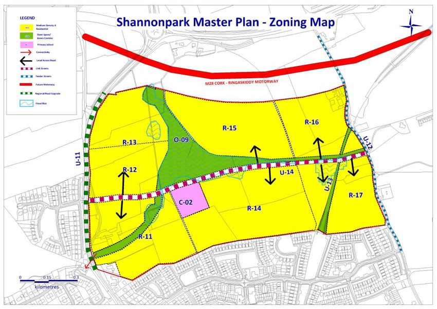
town, south of the Shannonpark Roundabout that was zoned for urban Planning and Development (Amendment) Act 2010. (PFRA) for Cork and the entire Shannonpark site has been
development in the October 2007 amendment to the 2005 Carrigaline mapped. There is a pluvial flood risk identified through the PFRA
Local Area Plan. The amendment made provision for the preparation of 1.4.13. Ballyhemiken Bridge located on the Rock Road is listed
and the OPW have advised that any future development on land
a master plan for the area, which comprises a total site area of 44 on the National Inventory of Architectural Heritage. The bridge is
affected will require a more detailed Flood Risk Assessment (FRA)
hectares with two owners. It is estimated that the master plan could located on the rock road and is a former railway bridge. It is a
as required by the Flood Risk Guidelines.
make provision for approximately 1000 new housing units. triple-span red brick road bridge, built in 1903, spanning the former
railway line. Square-headed arches, having coursed red brick piers Transportation and Road Network
1.4.7. One of the principal issues arising in relation to future housing with rock-faced limestone quoins. Cast-iron girder and concrete
development in Carrigaline is the question of appropriate densities, 1.4.18. Cork County Council commissioned consultants to carry
deck to flat arch, with English bond red brick parapets having
particularly the impacts of higher densities and meeting the demands of out a Transport Assessment on the Shannonpark lands in order to
tooled limestone coping stones. It is a reminder of the scale of the examine the transport impact of the proposed development on the
a returning market. railway network which once crossed the country.
local road network in the future. This assessment was carried out
Site Location and Size 1.4.14. Ecology: A preliminary Ecological Appraisal of the in accordance with the NRA Traffic and Transport Assessment
1.4.8. The Masterplan site is located mainly to the north of the town Shannonpark site was carried out in January 2015. The purpose of Guidelines (May 2014). The assessment identified that the
along the main Cork Road (R611) and is adjacent to the Shannonpark the appraisal was to assess the baseline ecological conditions for provision of between 150-200 houses in phase 1of the
Roundabout and the N28 road to Ringaskiddy. A small portion of the each site, to identify the key ecological resources to be retained Shannonpark Masterplan will not have a significant impact on
land in the north will be cut by the proposed re-alignment of the N28 and where necessary identify the scope of further ecological prevailing traffic conditions, however it should be noted that
motorway to Ringaskiddy and the southern boundary of the existing surveys. While the site is connected ecologically to the Cork delays and queues will be evident at the Shannonpark Roundabout
housing estate of Heron’s Wood. The eastern boundary of the site is the Harbour (via Glounatouig stream), it is suitable for development and at the various roundabouts located along the R611.
Fernhill Golf Course. The whole Masterplan area lands are is gently because it has largely agricultural habitats that are widespread. 1.4.19. The transport assessment demonstrates that the
sloping northwards to a valley that runs east west through the site, The report has identified some area of greater sensitivity, it has
development of 150-200 houses can proceed as part of Phase 1
thereby giving opportunity for drainage and open space. Primarily the recommended a number of additional surveys to be undertaken
subject to improvements as detailed below to the Shannonpark
lands are composed of hedgerow-enclosed farmland being interspersed before development can take place:- roundabout prior to the development commencing on site. The
with a number of derelict farm houses and outbuildings. same infrastructure requirements apply to Phase 3 if it commences
8first. It is recommended that the following improvements are The provision of a 100m southbound lane to serve both left be attractive place to live for people from all walks of life.
undertaken by the developer before development commences:- turning and straight ahead traffic approaching the Carrig na
Curra junction from the north;
The provision of a 240m long merging lane to the south of
Shannonpark Roundabout: the junction; 1.4.24. A set of principles will detail the formulation and guidance
A two-lane approach to the Shannonpark Roundabout from The conversion of the existing left only lane from the south of the Shannonpark site under the headings of housing, urban
Ringaskiddy. This additional lane of around 70m will serve into the Carrig na Curra housing estate to serve both left design, transport and mobility, green infrastructure community
both left turning and right turning traffic. This will improve turning and straight ahead traffic and the conversion of the uses, business uses water services and flood risk.
conditions at this location. However, as noted above the existing straight ahead lane to a right turn lane serving the Master Plan Concept
roundabout will remain at over capacity into the future both Shannonpark Masterplan site. This realignment of traffic
with and without the proposed development. lanes is to facilitate the provision of two southbound 1.4.25. The design and layout of the masterplan site has strong
underlying principles which will help deliver an innovative layout
Provision of two exiting northbound lanes to Cork that straight ahead lanes from the north
and format that will integrate with Carrigaline.
merge prior to the L6469 local road. The provision of a second access to the Shannonpark
Masterplan site from the Rock Road. 1.4.26. The concept of the site layout was also guided by a flood
Carrig Na Curra Junction: risk assessment that the principle landowner commissioned. This
identified a central area measuring 8.5 hectares at risk of flooding.
The construction of a short southbound left-turning lane for This informed the layout of the master plan site with open space
1.4.21. The Transport Assessment (TA) outlined the total
the Shannonpark Masterplan site on the R611. This left- and additional recreation areas being allocated here.
infrastructure requirements for the provision of up to 1000 houses.
turning lane should be approximately 25m in length.
For the benefit of constructing the traffic model 0-200 houses and Promote a strong sense of identity and distinctiveness
200-500 houses and upwards to 1000 houses were tested. The through the provision of the primary amenity space at the
1.4.20. Further development beyond 200 houses is likely to give conclusion of the model detailed a list of infrastructure that is centre of the site.
rise to significant impacts on the Shannonpark Roundabout. An required to facilitate the development. The network improvements
relate to the Shannonpark roundabout and the R611 and it would Ensure strong connectivity with Carrigaline and the
initial assessment of 300 houses showed congestion along the
be preferable that the upgrades to the R611 are completed as early hinterland through the arrangement of the linear park in its
R611 increasing and that the resultant queues from the
as possible to minimise disruption and to reduce costs. central location
roundabouts along the R611 and the signalised junction at Carrig
na Curra had the potential to impact on the operation of the 1.4.22. In the longer term and to facilitate the Shannonpark Utilise the old railway line as an active amenity and promote
Shannonpark Roundabout. The following infrastructure is required Masterplan and the development of services within the Carrigaline same as a real route and asset
for the development of additional housing at Shannonpark. area, improvements within the town centre will be required which Break down the scale of the development through the
will both manage the demand to travel by car and provide provision of individual neighbourhoods, each with their own
additional transport capacity to support additional trips within the character and identity
Between 200-500 houses town.
Preserve existing vegetation, topographical feature and field
An additional 60m long southbound lane to serve both left
patterns (mature hedgerows) where appropriate.
turning and straight ahead traffic approaching the Carrig na
Curra junction from the north; Development Vision and Principles Prioritise the quality of architectural and urban design.
The provision of a 240m long merging lane to the south of 1.4.23. The overall vision for the development of these lands at Watercourses should be maintained as close to their natural
the junction. Shannonpark is informed by the 2011 Carrigaline Local Area Plan state as possible with minimal culverting. A mixture of open
X-01 Zoning Objective. All informing decisions for the banks and over hanging bank side vegetation is considered
The conversion of the existing left only lane from the south Shannonpark development should be assessed within the context the most natural.
into the Carrig na Curra housing estate to serve both left of this stated vision:
turning and straight ahead traffic and the conversion of the 1.4.27. A total of three development phases (1, 2 and 3) are
existing straight ahead lane to a right turn lane serving the identified within the development site. Phases 1 and 2 have one
Shannonpark Masterplan site. This realignment of traffic owner and measure 34 hectares and the lands identified as Phase
lanes is to facilitate the provision of two southbound Table 1.8: Shannonpark Vision 3 have a different landowner. The masterplan specifies, for each
straight ahead lanes from the north phase, the number of residential units, commercial uses,
The development of the site that will optimise the site’s educational facilities, social facilities, amenities, physical
A planning application for the upgrade of the Shannonpark development potential in a manner that will be socially, infrastructure and access strategy required, thereby setting out the
roundabout or M28 junction improvement at Shannonpark. environmentally and economically sustainable delivering a enabling works that are required to allow development to
high quality, mixed-use development that is in accordance commence. The three phases will equate to residential zoning
with the Carrigaline electoral Area local Area Plan X-01 objectives in the Local Area Plan.
Up to 1000 houses
Zoning objective and that provides optimum opportunity for
non-private car transport use. This will ensure the creation of 1.4.28. Development within each phase should vary in terms of
a new residential quarter in the town of Carrigaline which will housing type in order to avoid uniformity in design. The overall
9layout will include an east west street link the construction of 1.4.37. The following tables set out the infrastructure and service
which will be shared by the developer or developers. The phased requirements for Phases 1a and 1b as set within the overall
area descriptions are not intended to be overly prescriptive carrying capacity of the masterplan lands.
regarding the form and visual appearance of future development,
but rather set out an overall framework which will include guidance
on land use mix that will inform future planning applications. This
Infrastructure required for 0-200 Implementation
guidance should lead to a series of co-ordinated high quality
dwellings Phase 1a
developments across the master plan site which can respond to
specific site characteristics and plan for facilities. Signalisation of the Carrig na Curra Developer
Phasing and Implementation Junction
1.4.29. Specific development guidance on the required
The entrance serving the Shannonpark Developer
infrastructure provision for each development phase is outlined in
Masterplan site will need to include
this Local Area Plan. This approach allows infrastructure providers
both a dedicated left-turn and right
and project developers to plan for the long term without having to
turn-lane. In addition, the operation of
provide large cost infrastructure in advance of its need.
this signalised junction should be
1.4.30. The financing and timely delivery of the physical, social upgraded to ensure that traffic on the
and community infrastructure required for the lands needs to be Figure 1: Phasing Programme R611 is provided priority during peak
clearly outlined to inform project advancement. times
1.4.31. The phasing of the masterplan site shall consist of three
Construction of East-West link street Developer
phases; phase 1 will be divided into phase 1a and 1b, phase 2 and
(U-15)
phase 3. Prior to development commencing a SUDs Study shall be
prepared. Phase 1
Cycle/Pedestrian Network Developer?Cork County
1.4.32. Phase 1a will contain upwards of 200 houses and Phase 1.4.34. This phase of the development is divided in two parts; Council
1b will contain an additional 100 houses. However construction phase 1a and phase 1b and covers a developable area of
work on Phase 1b will not commence until the infrastructure approximately 12.8 hectares (R-11, R-12 and R-13) and will provide Implementation of SUDs Study Developer
deficiencies identified in the Transport Assessment are in place. for up to 300 residential units. Phase 1a measures 5.3 hectares and recommendations
Phase 2 will be approx. 500 houses and phase 3 upwards of 200 contains residential zoning R-11 and R-12. As R-11 fronts the
houses. The traffic assessment details the infrastructure regional road, it is important that provision is made at this location
requirements before development commences and what is for a pedestrian/cycling crossing to allow connectivity across the
required for each phase. R611 to access the proposed educational campus on the lands to Infrastructure required for > 200- Implementation
the west. This access point will also link into the network of open dwellings Phase 1b
1.4.33. The residential densities on the entire masterplan site are space on the masterplan site.
guided by the requirements of Medium ‘A’ in the Cork County A planning application for the upgrade Cork County Council/NRA
Development Plan 2014. 1.4.35. Phase 1a will include a site for a public transport
interchange and a local commercial centre, including any of the Shannonpark roundabout or
community facilities. The proposed public transport interchange M28 junction improvement at
should be located in close proximity to the R611 to faciliate ease of Shannonpark
access by public transport. The exact location and size of the
public transport interchange shall be agreed with Bus Eireann and An additional 60m long southbound Developer
Cork County Council’s Traffic and Transportation Section ideally lane to serve both left turning and
prior to the making of a planning application. The location of the straight ahead traffic approaching the
commercial centre should be in close proximity to the transport Carrig na Curra junction from the
interchange to allow centralisation of and sharing of car parking. north;
Phase 1a is the land closest to the regional road connecting The provision of a 240m long merging
Carrigaline to the Shannonpark roundabout and the N28. Provision lane to the south of the junction;
is made in this phase for part of the central open space which will
The conversion of the existing left-
run east west through the spine of the site.
only lane from the south into the
1.4.36. The construction of Phase 1b can only commence once Carrig na Curra housing estate to
the infrastructure requirements as identified in the Traffic serve both left turning and straight
Assessment have been implemented. Additional infrastructure is ahead traffic and the conversion of the
required for later phases. existing straight ahead lane to a right
10You can also read