Installation and operation of a grid connected solar park with an export capacity of c. 49.5MW at North Dairy Farm, Pulham, Dorchester, DT2 7EA ...
←
→
Page content transcription
If your browser does not render page correctly, please read the page content below
Installation and operation of a grid

connected solar park with an export capacity

 of c. 49.5MW at North Dairy Farm, Pulham,

            Dorchester, DT2 7EA

 REQUEST FOR ENVIRONMENTAL IMPACT ASSESSMENT
               SCREENING OPINION

                September 2020

                 Prepared By
Project Quality Control Sheet

 ORIGINAL                  Author                      Checked by                Approved by

 Signature

 Date                      02 September 2020           02 September 2020         02 September 2020

 Company                   Aardvark EM Ltd             Aardvark EM Ltd           Aardvark EM Ltd

Location:                 North Dairy Farm, Pulham, Dorchester, DT2 7EA
Grid Reference:           ST 729080
Project Manager:          Nick Leaney BSc Hons MRICS
Report Author:            Rachel Ness BSc Hons
                          Kirsty Lodge BSc Hons AssocRTPI
Report Number:           1972-R001
Report Status:            FINAL

Copyright:                All copyright in this document is reserved.

Liability:                This document contains information and may contain conclusions and
                          recommendations. Every effort has been made to ensure that the information
                          is accurate and that the opinions expressed are sound. However, Aardvark EM
                          Limited cannot be made liable for any errors or omissions or for any losses or
                          consequential losses resulting from decisions based on the information.

                                  Report Written and Produced By
             Aardvark EM Limited, Higher Ford, Wiveliscombe, Taunton, Somerset, TA4 2RL
                         Telephone: 01984 624989, Facsimile: 01984 623912
                 Email: environment@aardvarkem.co.uk, Web: www.aardvarkem.co.uk
Contents

1   Introduction .................................................................................................................. 1
2   Site Location and Description .................................................................................... 3
3   The Proposed Development ....................................................................................... 9
4   EIA Screening Process ............................................................................................. 15
5   Potential Effects on the Environment ..................................................................... 17
6   Conclusion ................................................................................................................. 34
7   Appendices ................................................................................................................ 35
North Dairy Farm Solar Park - EIA Screening Request

1 Introduction

1.0 Aardvark EM Ltd has been instructed by British Solar Renewables (BSR) (‘the applicant’), to
    formally request an Environmental Impact Assessment (EIA) Screening Opinion from Dorset
    Council (DC) with regards to the proposed development of a solar photovoltaic (PV)
    generating station on land at North Dairy Farm, Pulham, Dorchester, DT2 7EA (‘the site’).

1.1 This request is made under Regulations 6 (1) and 15 (1) of the Town and Country Planning
    (Environmental Impact Assessment) (England) Regulations 2017 (‘the EIA Regulations’).

1.2 The proposed development comprises the following;

          ‘Installation and operation of a grid connected solar park with an export
          capacity of c. 49.5MW and battery storage facility area’

1.3 The proposed development does not fall within Schedule 1 of the EIA Regulations.

1.4 In line with requirements of Regulation 6(2) of the Regulations, this request contains the
    following information to assist DC in adopting an EIA Screening Opinion:

      •   A plan sufficient to identify the land;
      •   A description of the nature and purpose of the proposed development; and
      •   A description of the aspects of the environment likely to be affected by the proposed
          development and the likely significant effects, taking into account:
          a. Schedules 2 and 3 of the EIA Regulations;
          b. The characteristics of the proposed development; and
          c. The location of the proposed development and its surrounds.

1.5 Based on the preliminary assessments undertaken and shared in this report, it is considered
    that the proposed solar park is unlikely to require EIA due to the low potential for significant
    effects arising individually and cumulatively from its development.

1.6 Without prejudice to a decision in respect of the requirement for an EIA, and in the event the
    Council determine that an EIA should be provided with any planning application, it is
    requested that the required scope of the Environmental Statement is identified as part of the
    EIA Screening Opinion.

                           Aardvark EM Limited - September 2020                         Page 1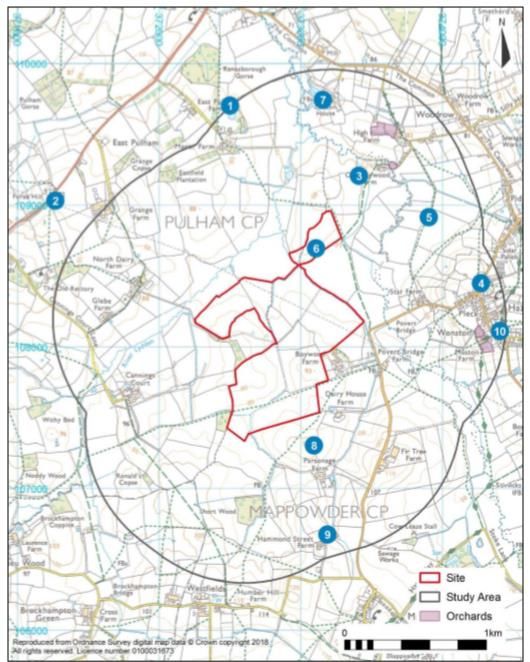
North Dairy Farm Solar Park - EIA Screening Request

    The Applicant

1.7 BSR is a leading renewable energy developer and provider of expert services to the
    renewable energy industry. The company was founded in 2010 from when it has grown into
    one of the largest integrated developers in the UK with over 350MW of ground mounted
    solar PV parks successfully installed to date. Its portfolio includes building the four largest
    solar sites in the UK:
     •   Bradenstoke in Wiltshire (69.8MW on an 86ha site);
     •   Owls Hatch at Herne Bay in Kent (51.9MW on an 80ha site);
     •   Shotwick in Flintshire (72.2MW on a 101ha site and is the largest solar park in the UK);
         and
     •   Swindon in Wiltshire (60.2MW on a 70ha site).

1.8 BSR is based in Somerset and as a company is founded on the fundamentals of land
    management and quality British engineering practices. In addition to building solar parks,
    BSR are responsible for the operation of 390MW of solar.

                         Aardvark EM Limited - September 2020                           Page 2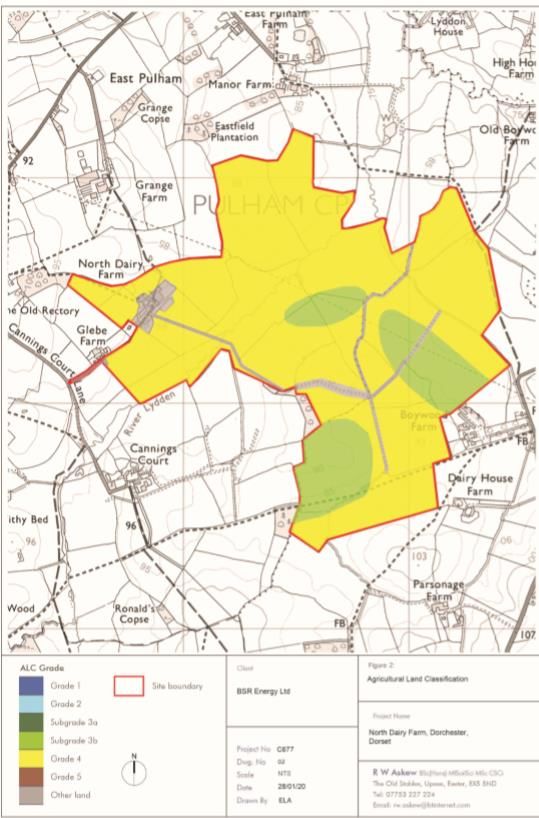
North Dairy Farm Solar Park - EIA Screening Request
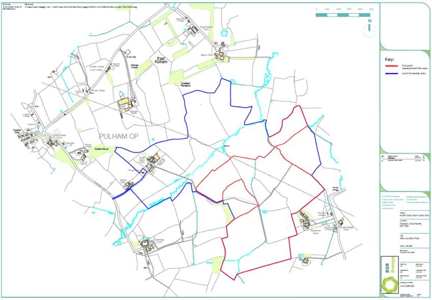
2 Site Location and Description
2.0 The proposed site is located within Blackmore Vale between the villages of Pulham (to the
west) and Hazelbury Bryan (to the east). It is shown by the redline on the plan at Appendix
7.1 which is also presented as Figure 1 below. The Ordnance Survey grid reference at the
approximate centre of the site is ST 729080.
Figure 1: Site Location Plan showing extent of North Dairy Farm and Proposed Solar Park Site
2.1 The site comprises an area of mixed rotation farmland consisting of cereal crops
(predominantly maize) on its southern half and improved ley grassland on its northern half. It
covers an area of c. 76ha and its fields are bounded by hedgerows and streams, the latter
draining into the River Lydden to the north of the site. The agricultural land value is Subgrade
3b (moderate) and Grade 4 (poor) and forms part of the wider 168ha North Dairy Farm land
holding.
2.2 The majority of the site is located within the Parish of Mappowder, with the site access
(Cannings Court Lane) and northern extent of the proposed solar farm located in the Parish
of Pulham.
Aardvark EM Limited - September 2020 Page 3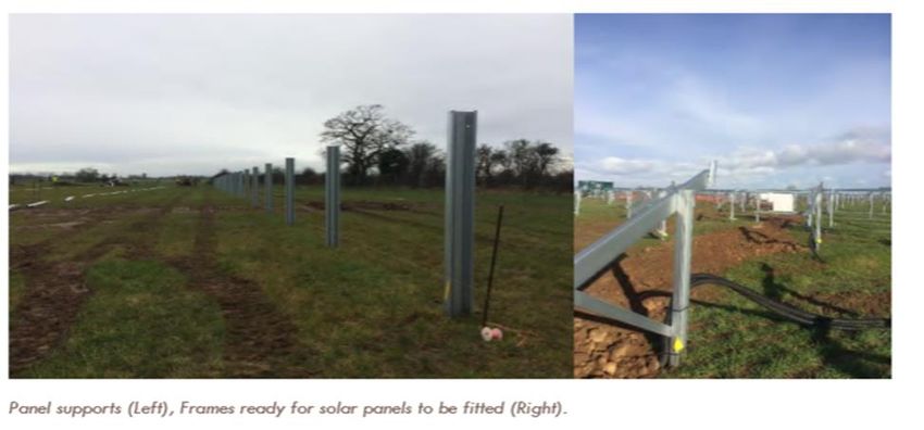
North Dairy Farm Solar Park - EIA Screening Request

2.3 It is proposed that access to the site would be provided using the existing access road to
   North Dairy Farm, namely Cannings Court Lane. There are a number of Public Rights of Way
   (PRoW) in close proximity to the site (N49/4; N46/19; N46/21; N46/28) as well as one
   crossing through the site (N46/20). There will be no requests to close any PRoW as part of
   the proposed development.

2.4 The wider landscape consists of mixed farmland similar to that found at North Dairy Farm,
   and also includes small blocks of broadleaf woodland set in an undulating and rolling
   landscape with scattered farmsteads. The Dorset AONB is located to the south east, south
   and south west of the site and is at its closest approximately 1.25km away.

2.5 The Environment Agency’s flood map for planning indicates that the majority of the site is
   located within Flood Zone 1 (low risk) with limited areas along parts of the northern boundary
   adjacent to the River Lydden within Flood Zones 2 and 3 (medium and high risk,
   respectively). The proposed development avoids Flood Zones 2 and 3.

2.6 The area surrounding the site has been assessed for the presence of key statutory
   designations within 2km of its boundary. The results are summarised below.

     Area of Outstanding Natural Beauty (AONB)       Dorset AONB 1.25km at its closest to the site

     National Nature Reserves (NNR)                  None Identified

     National Parks                                  None Identified

     Ramsar Sites                                    None Identified

     Sites of Special Scientific Interest (SSSI)     Blackmoor Vale Commons and Moors 1.3km
                                                     north east of site

     Special Areas of Conservation (SAC)             Rooksmoor SAC 1.9km north east of site

     Special Protection Area (SPA)                   None Identified

     Plantation on Ancient Woodland Site (PAWS)      Adjacent to west boundary of the site (Humber
                                                     Wood). Woodland cleared and now an
                                                     improved grassland field with some retained
                                                     oak trees along a farm track

     Sites of Nature Conservation Interest (SNCI)    6 sites within 2km of the site identified for their
                                                     habitats

     Conservation Areas                              2 Conservation Areas. Hazelbury Bryan c.750m
                                                     to the south and Mappowder c. 1.3km to south
                                                     east.

     World Heritage Site                             None Identified

                           Aardvark EM Limited - September 2020                            Page 4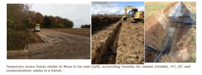
North Dairy Farm Solar Park - EIA Screening Request

     Scheduled Monument (outside the 2km radius)     2 Scheduled Monuments. Both hillforts at
                                                     Dungeon Hill 3.2km to south-west and
                                                     Rawlsbury Camp 3.8km south east of the site

     Registered Parks and Gardens                    None Identified

     Listed Buildings                                C. 50 Listed Buildings (predominately Grade II)

   Site Selection

2.7 One of the key considerations when proposing a renewable energy scheme is where and
   how to gain access to the grid distribution network. Proximity to an overhead power line is
   key for successful unsubsidised solar energy generation, avoiding the substantial costs,
   impacts and inefficiencies of laying lengthy sections of underground cable.

2.8 The SSE network has a 132kV overhead line passing through North Dairy Farm. The
   applicant has accepted the grid offer from SSE and secured the export capacity required for
   the project. The grid offer accepted can only be used for North Dairy Farm and is non
   transferrable to any other site.

2.9 Having established an acceptable point of grid connection, the proposed 76ha site was
   identified following a comprehensive preliminary planning and environmental appraisal of the
   entire North Dairy Farm landholding covering c. 168ha of fields (see blueline area on Figure
   1 above). The preliminary impact assessments identified where constraints and opportunities
   were located on and outside of the land holding relative to the development of a proposed
   solar park (see Figure 2 below):

       •   Proximity to sensitive human receptors: the need to protect nearby residential
           dwellings from noise and construction traffic impacts has been a key consideration.
           This included introducing a ~250m buffer from the closest noise sensitive properties
           within which no inverters or transformers would be located. This led to modifications
           to the Concept Design (Figure 3 below).

                           Aardvark EM Limited - September 2020                         Page 5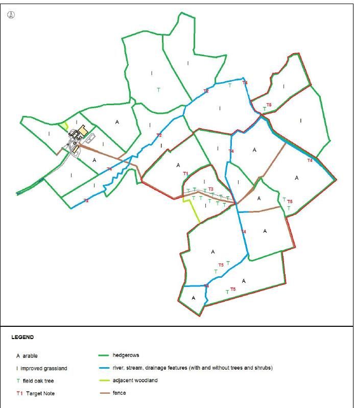
North Dairy Farm Solar Park - EIA Screening Request

Figure 2: Constraints and Opportunities Identified by Preliminary Environmental Appraisal (168ha)

    •   Heritage: the need to avoid where possible impacting designated heritage assets
        and archaeological remains both within and adjoining the site. The review of heritage
        assets which may be affected by the proposed development contributed to the
        redline selection process, leading to mitigation through design. This included the
        identification and retention of the hedgerows along some of the field boundaries
        which may be of historic interest, and the avoidance of fields for use by solar that
        would affect the setting of listed assets e.g. the Grade II* Listed Church of St Thomas
        a Becket and The Old Rectory 1km west of the site.

    •   Landscape and visual considerations: this identified fields with a high landscape
        and visual sensitivity relative to their setting with views from the farmstead, cottages
        and PRoW, together with those fields which have a strong landscape character and
        intervisibility to the surrounding landscape and farmsteads. These fields (14-15 and
        19-27 on Figure 2) were accordingly removed from consideration for solar panel
        development.

    •   Ecology and biodiversity: the preliminary ecological appraisal identified the need to
        protect all hedgerows, streams, tall ruderal/grass margins, a pond and field trees as

                       Aardvark EM Limited - September 2020                           Page 6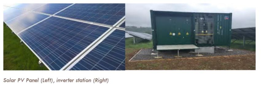
North Dairy Farm Solar Park - EIA Screening Request

             habitats having elevated ecological interest. These have all been retained in the
             Concept Design and appropriate (5m) ecological buffer zones provided that take into
             account the farming practices employed on the land.

         •   Access and traffic: a suitable access for construction vehicles is essential for the
             development of a solar farm. The existing farm access was identified as part of the
             preliminary assessment as being suitable for this purpose (and subsequent
             operational management purposes) thereby avoiding the need to create a new
             access.

         •   Flood risk: as an “in principle” approach inappropriate development in areas at risk
             of flooding should be avoided by directing development away from areas at highest
             risk, but where development is necessary, making it safe without increasing flood risk
             elsewhere. Flood Zones 2 and 3 have been avoided in the Concept Design, with all
             solar panels located in Flood Zone 1 (low risk). Furthermore, areas of medium and
             high surface water flood risk have also been avoided.

         •   Agricultural land: Ground mounted solar parks are temporary structures and as
             such they do not lead to the sterilisation of agricultural land. National policy seeks to
             minimise impact on the best and most versatile (BMV) agricultural land except where
             this would be inconsistent with other sustainability considerations. Desk based
             assessment of North Dairy Farm originally identified the potential for Grade 3a land
             (BMV) within the farm land holding. To inform the choice of solar development area a
             semi detailed agricultural land classification survey was undertaken to identify any
             Grade 3a land with a view to avoiding its development if possible. The survey
             identified that, in fact, none of the land was Grade 3a so this was discounted as a
             constraint to solar development.

2.10 In addition to the above outlined considerations, there are also a range of technical and
     commercial factors which must also be taken into account when considering site selection for
     solar parks:
         •   Solar irradiation levels and shading: this is a key consideration for solar site
             selection, and North Dairy Farm offers good levels of irradiance and large open
             fields.
         •   Topography: the preference is for fields with southerly aspects and generally flat
             such as those found at North Dairy Farm.

                           Aardvark EM Limited - September 2020                           Page 7
North Dairy Farm Solar Park - EIA Screening Request
• Land availability: this is key as without a land agreement being in place with the
landowner, delivery of the renewable energy project is not possible. In this case
commercial terms have been agreed with the landowner of North Dairy Farm.
2.11 All of these factors informed an iterative design approach and led to the proposed Concept
Design (see Figure 3 below).
Figure 3: Proposed Concept Design Layout (76ha)
Aardvark EM Limited - September 2020 Page 8North Dairy Farm Solar Park - EIA Screening Request
3 The Proposed Development
Description
3.0 The proposed development comprises the construction, operation, management of a solar
park for a temporary period of 35 years from the date of the first exportation of electricity from
the site. After the 35 year period the solar park would be decommissioned.
3.1 The solar park would have an approximate design capacity of 49.5MW and would generate
an estimated 49,500MWh of clean, renewable and sustainable electricity per year. This is
equivalent to the annual electrical needs of approx. 13,000 family homes. The anticipated
CO2 displacement is around 13,000 tonnes per annum. This is equivalent to removing 5,841
conventional cars from the road each year.
3.2 The proposed planning application will seek full planning permission for a ground-mounted
solar PV park including battery storage.
3.3 Full details of the Concept Design are provided at Figure 3 and includes the following
components estimation which are explained in more detail in Boxes 1 – 8 below:
• Solar photovoltaic (PV) panels, ground mounted to a railing sub structure;
• 14 inverter stations distributed evenly across the solar park;
• 14 transformers;
• Compacted internal crushed stone tracks (constructed on a sub layer of geogrid
membrane) to allow vehicular access between fields;
• Fencing 2.2m high and gates enclosing the panels within each field and allowing
sheep to graze securely;
• Security and monitoring CCTV mounted on 3m high fence posts within each field;
• Underground cabling to connect the panels to the proposed substation;
• A security-fenced enclosed substation compound for both the Developer and SSE as
the DNO, including associated services which will connect to the existing overhead
power line; and
• A substation access track with a cement based top layer (a statutory requirement of
SSE) which already exists.
Box 1: Solar PV panels
• Solar panels would be laid out in rows with gaps of approximately 2-6m between each
row depending on the topography of particular fields. Panels are mounted on a frame
made of galvanized steel or aluminium. The arrays would be static.
Aardvark EM Limited - September 2020 Page 9North Dairy Farm Solar Park - EIA Screening Request
• Panels would be mounted in an optimised configuration for absorbing year-round solar
irradiation, typically in straight arrays set at an angle of c.22 degrees from east to west
across field enclosures. At their lower edge panels would be approximately 0.8m from
the ground and up to approximately 2.6m at their higher edge.
• The positioning of the arrays respond to existing physical features such as ditches,
ponds, trees and hedgerows with panels set back appropriate buffer distances as
informed by relevant guidance.
Box 2: Inverter Stations and Transformers
• Approximately fourteen inverter stations will be located throughout the site. The
inverters sit inside metal cabinets that will be finished in green/white and positioned on
a hardcore or concrete slab base. The cabinets are relatively low in height, up to 3.4
metres.
• The transformers are located next to the inverters and are relatively low in height,
2.5m.
Box 3: Access
• The site would be accessed via the existing lane to North Dairy Farm off Canning
Court Road. These lanes are already utilised by large farm vehicles. This access route
would be used both during construction and the remainder of the solar park’s duration.
• Compacted internal tracks would be utilised to facilitate vehicle movement around the
site for construction and maintenance purposes. Where possible tracks will make use
of existing agricultural routes. Any additional routing would be constructed on a sub
layer of geogrid membrane with crushed stone on top.
Box 4: Fencing and Security
• Fencing 2.2m high comprising wooden deer fence poles and galvanised fence with
gates to enclose the panels within each field and allow sheep to graze securely.
• The perimeter of the site would be protected by a system of CCTV and/or infra-red
cameras, which would provide full 24-hour surveillance around the internal perimeter.
An intelligent sensor management system would manage the cameras. Cameras
would be inward facing on poles of up to approximately 2.5-3m high, spaced at
approximately 50m intervals along the fence. There would be no lighting within the site
at night-time.
Box 5: Cabling
• Cabling will be required to connect the proposed development to the Point of
Connection (POC) to the energy transmission network via the new proposed
substation
• The route of the cabling will not require works outside the site
• The cables linking all the arrays to the inverter/transformer stations and the substation
would be underground
Aardvark EM Limited - September 2020 Page 10North Dairy Farm Solar Park - EIA Screening Request
Box 6: Substation
• There would be one substation measuring approximately 50m x 40m at the centre of
the site adjacent to an existing 132kV pylon/overhead lines. This existing pylon
provides the point of connection to the local electricity network.
• It would be located within a security-fenced concrete-based compound.
• The 132kV overhead wires would provide the POC from the substation to the 132kV
pylon from where the electricity will be exported to the National Grid network.
• The substation would receive electricity from the inverters and batteries before
transferring it to the National Grid network. Solar arrays, inverters, batteries and
substation would be connected by underground electrical cables.
• A 10m high single pole communications antenna may be required at the substation.
Box 7: Batteries
• A potential future battery storage area, comprising a hardcore or slab base measuring
50m by 50m.
• Batteries would be housed within shipping containers or similar, with each unit
measuring approx. 12m x 3m x 3m. It will be positioned in the central area of the
development
Box 8: Environmental Mitigation and Enhancement
• Land between and beneath the panels would be used for sheep grazing and
managed to deliver biodiversity enhancements
• Appropriate environmental mitigation and enhancement will be identified as part of the
assessment work undertaken to inform the planning application
Construction
3.4 A Construction Environmental Management Plan (CEMP) would be implemented to control
construction related impacts.
Figure 4: Images of Typical Construction Works for Solar Park
Aardvark EM Limited - September 2020 Page 11North Dairy Farm Solar Park - EIA Screening Request
3.5 The main construction groundwork involves trenching for the installation of the underground
cables to connect the solar arrays to the substation.
3.6 Top soil would be stripped (stored in a small bund) to create a ‘working lane’ approximately
10m wide. A trench is dug in the subsoil and excavated material is stored in another onsite
bund. The deepest trench would be approximately 1.2m deep for the high voltage cables, for
which a medium sized mechanical excavator would be used. Approximately 4km of this
trench type would be required.
3.7 Approximately 7km of low voltage 0.6 m deep cable trenching would be required and
possibly a further 1km of 0.6m deep communications cable trenching.
3.8 The cable would be laid or winched into the open trench and the trench backfilled with the
excavated subsoil. Generally, cable is installed in 500m lengths with a joint pit or bay at each
end to allow a mechanical joint to be applied to each length of cable. A joint bay is excavated
3m long x 2m wide x 1.5m deep to allow an engineer to install the joints. The joint pit is
backfilled as per the trench. The area of the site which would be disturbed through trenching
for cables is expected to be 1% of the total site area.
3.9 Where the cable alignment crosses through hedges, routine practice would be to create a
small opening approximately 3m wide providing sufficient space for an excavator and dumper
towing the cable trailer through, thereby allowing the cable to be installed as a continuous
length. Where ditches need to be crossed, cables would make use of existing bridges,
culverts or crossings between fields. If this is not possible then cables would be placed under
the invert level of the ditch so as not to obstruct the drainage channels.
3.10 A railing sub structure would be piled into the ground, frames attached and then the solar
panels would be mounted to the frames. The railings are pile-driven (like a fence post)
approximately 1.5m below ground level which means that no concrete is needed to secure
the system and the posts can be easily removed with no permanent impact at the end of the
development’s temporary consenting period.
3.11 The area for the base of the substation would be excavated prior to the hardstanding plinth
concrete pour, after which the associated substation infrastructure would be installed.
Constructing the panel support piling and substation base would disturb a further 1% of the
solar park area.
Aardvark EM Limited - September 2020 Page 12North Dairy Farm Solar Park - EIA Screening Request
Figure 5: Images of solar panel support railings during construction
3.12 During construction one construction compound would serve the site and this will be located
adjacent to the farm, thus reducing the distance delivery vehicles will need to travel after
reaching the site's entrance. The temporary compound would likely include:
• Temporary portable buildings to be used for offices, welfare and toilet facilities;
• Containerised storage areas;
• Parking for construction vehicles and workers vehicles;
• Temporary hardstanding;
• Temporary gated compound; and
• Wheel washing facilities and road sweeper if ground conditions require, preventing mud
and loose material being transferred onto the local highway network.
3.13 The construction phase is expected to take around 4 months, and it is proposed that works
will be undertaken between 0700 – 1800hrs Monday to Saturday and 0900 – 1700hrs on
Sunday.
3.14 Around 940 two-way vehicle movements would occur during this period associated with the
arrival and departure of a variety of construction vehicles. This equates to some 8-10 two-
way vehicle movements per day. There would be no abnormal loads.
Operation
3.15 Solar panels convert sunlight to electrical energy. They generate direct current (DC) that is
converted by the inverter stations to alternating current (AC) that would then be exported to
the National Grid network.
Aardvark EM Limited - September 2020 Page 13North Dairy Farm Solar Park - EIA Screening Request
3.16 PV systems are rated for capacity in watts (or kW or MW) with the designation 'peak' (e.g.
kWp, MWp). The peak capacity of individual panels is established by measuring their
performance under internationally recognised standard conditions that include temperature
and wavelength of sunlight. The actual output of a system will be determined by latitude,
local weather and site conditions. The solar park would have an estimated design peak
capacity of 49.5 MWp of renewable electricity.
3.17 During the operational phase, the activities on site would amount to servicing of plant and
equipment and vegetation management. A Landscape and Ecological Management Plan
(LEMP) would set out how the land would be managed throughout the operational phase of
development. Minimal maintenance generates one vehicle movement per week.
Figure 6: Images of typical solar panel and inverter station
Decommissioning
3.18 The solar park would export renewable energy to the grid for 35 years following which it
would be decommissioned.
3.19 Overall, if decommissioning of the solar arrays and any battery storage area runs
concurrently it is expected to take 14 weeks, generating 80 vehicle movements per week.
3.20 A Decommissioning Statement will be included with the planning application to provide an
outline for removal and reinstatement at the end of the scheme’s temporary occupation of the
site.
Aardvark EM Limited - September 2020 Page 14North Dairy Farm Solar Park - EIA Screening Request
4 EIA Screening Process
Determining the need for an EIA
4.0 A requirement for Environmental Impact Assessment considers the scale, nature and
location of proposed development and the likelihood of significant environmental effects
arising as a result.
4.1 Schedules 1 and 2 of the Regulations provide descriptions of that which could be EIA
development. For a type included under Schedule 1, EIA is mandatory. Where development
falls under Schedule 2, the need for EIA is determined based on set criteria, which are:
• Development falls within one of the classes of development stated in Schedule 2; AND
• EITHER exceeds the size threshold for that class of development; OR is in a sensitive
area as defined by the EIA Regulations; AND
• It is likely to have significant environmental effects due to factors such as nature, size or
location.
4.2 The exceedance of a Schedule 2 category threshold triggers the need to consider whether
the proposed development is EIA Development with reference to the following criteria set out
in Schedule 3 of the EIA Regulations:
• Characteristics of the proposed development (e.g. size, cumulative effects with
existing/approved development, use of natural resources, production of waste, pollution,
nuisance, risk of accidents, and risk to human health);
• Location of the proposed development (e.g. environmental sensitivity of the area); and
• Types and characteristics of the potential effects of the proposed development (with
particular regard to the extent, nature, magnitude and complexity, probability and
duration, frequency and reversibility of the effect, including the likelihood for
transboundary effects).
Aardvark EM Limited - September 2020 Page 15North Dairy Farm Solar Park - EIA Screening Request
Review against EIA Regulations
4.3 The proposed development is not a Schedule 1 development and does not automatically
require an EIA. However, it does constitute a project under category 3(a) of Schedule 2 of the
Regulations as an industrial installation for the production of electricity whereby the
applicable threshold to undertake screening is when the site area exceeds 0.5 hectares.
4.4 As the proposed development will cover an area c. 76ha it is appropriate to seek an EIA
screening opinion from Dorset Council (DC) as the relevant local planning authority (LPA).
Planning Practice Guidance
4.5 Planning Practice Guidance (PPG) provides guidance on EIA screening and how to assess
whether a development is likely to give rise to significant environmental effects, such as to
require an EIA. PPG 018 (Ref ID: 4-018-20170728)1 states, ‘only a very small proportion of
Schedule 2 development will require an Environmental Impact Assessment’.
4.6 In order to assist LPAs to determine whether a project is likely to require an assessment a
set of indicative thresholds and criteria have been prepared and presented as a tabulated
annex to the PPG (Paragraph 058 Reference ID:4-058-20150326).
Development Schedule 2 criteria Indicative criteria and Key issues to
Type and threshold threshold consider
3(a) Industrial The area of the Thermal output of more Level of emissions to
installation for development exceeds than 50 MW. Small air, arrangements for
the 0.5 hectare. stations using novel forms the transport of fuel
production of of generation should be and any visual
electricity. considered carefully. impact.
1 https://www.gov.uk/guidance/environmental-impact-assessment#Screening-Schedule-2-projects
Aardvark EM Limited - September 2020 Page 16North Dairy Farm Solar Park - EIA Screening Request
5 Potential Effects on the Environment
5.0 For this EIA screening report the characteristics of the proposed development together with
its location and potential effects have been assessed against the following considerations:
• Environmental Health (air quality, land contamination, noise and vibration);
• Cultural Heritage;
• Landscape and Visual;
• Ecology;
• Traffic and Transport;
• Flood Risk;
• Agricultural Land Quality and Soil; and
• Cumulative Impacts.
Environmental Health
5.1 Air Quality
• The site is not located within any air quality management zones.
• Control measures for air quality (and other environmental management matters) will be
set out in a Construction Management Statement (CMS) accompanying the planning
application. These would be implemented via a Construction and Environmental
Management Plan (CEMP) to effectively control and minimise environmental effects
associated with the construction works.
• The CEMP would be a detailed plan and method statement for a construction-ready
scheme and is anticipated to be required by DC as a pre-commencement submission in
the event permission was granted. This will include best practice measures relating to
appropriate working methods to minimise dust generation and ensuring that all plant and
machinery is operated responsibly and complies with relevant emissions standards.
• Following implementation of the specified mitigation, no significant effects on air quality
are considered likely.
5.2 Land Contamination
• The site has been in agricultural use since at least the late 1800s with no known
contamination and has a low risk of undetected ground contamination. A Contaminated
Land Risk Analysis has been undertaken. It identifies that there are no on-site sources of
contamination and no off-site sources within 100m.
Aardvark EM Limited - September 2020 Page 17North Dairy Farm Solar Park - EIA Screening Request
• The superficial hydrogeology underlying the site is classified as Secondary (A) Aquifer
(deposits with moderate permeability), which also forms the bedrock hydrogeology along
with an Unproductive Stratum (deposits of negligible permeability).
• The site does not lie within a groundwater Source Protection Zone (SPZ). There is one
general farming and domestic ground water abstraction licence within 500m of the farm
landholding, and there are no eco-receptors identified within that radius.
• It is concluded that there are no significant contamination linkages identified and
accordingly soil and groundwater liabilities are unlikely to occur.
• Development will be subject to relevant HSE and site-management environmental
obligations to protect against risk of causing ground contamination in-construction.
5.3 Noise and Vibration
• A preliminary noise assessment report is attached as Appendix 7.2. It details the baseline
noise survey, preliminary noise emissions from the operational development, and an
outline of relevant assessment methodologies for the construction phase.
• The baseline noise survey indicates that the site has a quiescent ambient sound climate,
representative of a typical rural location with farming activities. The baseline noise survey
results indicate that night time levels are lower than those measured during day and are
reasonably consistent at all nearest noise-sensitive receptors.
• The preliminary operational noise calculations indicate that that the development will give
rise to rating noise levels that are typically below the measured day and night time
background sound levels in the area. The results identify that the operation of the
scheme, as proposed, can occur without affecting the amenity of the closest residential
receptors to the site,
• Construction works have the potential to result in noise and vibration impacts due to
activities associated with plant use and construction vehicle movements. Controls for
noise and vibration will be outlined in the CMS and implemented via the CEMP.
• Preliminary construction noise levels have been predicted at the closest identified noise-
sensitive receptors based on the likely construction methodologies and programme, in
accordance with BS 5228. Based on guidance and having regard to the baseline noise
survey the construction sound levels comply with the requirements, thus causing no
significant impact.
• Following implementation of appropriate mitigation during the construction phase, and
appropriately designed and selected plant during the operational phase, no significant
effects on noise and vibration are considered likely.
Aardvark EM Limited - September 2020 Page 18North Dairy Farm Solar Park - EIA Screening Request
Cultural Heritage Impacts
5.4 A preliminary archaeology and heritage appraisal has been undertaken by Cotswold
Archaeology (Appendix 7.3) in order to inform this EIA Screening Request. The appraisal has
been informed by Historic England’s National Heritage List for England (for designated
heritage assets), Dorset Historic Environment Record and historic Ordnance Survey maps in
order to identify potential archaeology and heritage constraints which should be considered
as part of the planning process.
5.5 There are no designated heritage assets within the site. There are over 50 designated
heritage assets within a 2km buffer around the site, including Listed Buildings and two
Conservation Areas, in Hazelbury Bryan and Mappowder. In addition, two Scheduled hillforts,
Dungeon Hill and Rawlsbury Camp, are situated in the wider landscape (see Figure 7).
Figure 7: Designated Heritage Assets
5.6 Through the appraisal and site selection process it has been established that the proposed
development would be unlikely to affect the majority of these designated assets in any way.
However, a small number of designated heritage assets which may be potentially susceptible
to development have been identified and these should be appropriately considered as part of
the planning process. These include:
Aardvark EM Limited - September 2020 Page 19North Dairy Farm Solar Park - EIA Screening Request
• Grade II* Listed Church of St Thomas a Becket and The Old Rectory (with associated
Grade II gate piers), c. 1km west of the site;
• Grade II Listed Cannings Court Farmhouse, c. 750m to the south;
• Grade II Listed Old Boywood Farm c. 480m to the north-east;
• Grade II Listed Little Whitemoor Farm, located c. 700m to the north-east;
• Grade II Listed Manor Farmhouse, c. 880m to the north-east; and
• Grade II East Pulham Farmhouse, c. 1.2km to the north.
5.7 The appraisal has identified the potential for the presence of archaeological remains within
the site, largely associated with medieval agricultural land-use, but remains from other
periods cannot be entirely ruled out (see Figure 8). Based on the current understanding the
site is unlikely to contain any archaeological remains of the highest significance that would
constrain or prevent development. It is therefore considered that the development at the site
can be accommodated without significant environmental effects on the archaeological
resource, but this will need to be appropriately considered (potentially by making provision for
recording) as part of the planning application process.
5.8 A Heritage Desk-Based Assessment (DBA), incorporating archaeological assessment,
heritage settings assessment and impact assessment, will be submitted with the planning
application. This will be undertaken by Cotswold Archaeology, a Registered Organisation
with the Chartered Institute for Archaeologists (CIfA). The DBA will be undertaken in
accordance with the provisions of the National Planning Policy Framework (2019) and other
relevant key statute, policy, guidance and professional standards including the Chartered
Institute for Archaeologists’ Standard and Guidance for Historic Environment Desk-Based
Assessment and Historic England’s Historic Environment Good Practice Advice in Planning
Note 3: the Setting of Heritage Assets (Second Edition 2017).
5.9 The settings assessment as part of the DBA will consider the potentially susceptible
designated heritage assets so that the contribution of the wider landscape to their
significance is fully understood. The potential for the development to affect additional assets
will also be appropriately explored. This will allow for the potential development effects upon
that significance, i.e. as a result of change within the setting of those assets, to be assessed.
The detailed design of the proposed development will consider the settings assessment and
appropriate measures will be implemented to avoid and/or mitigate any adverse impacts.
Aardvark EM Limited - September 2020 Page 20North Dairy Farm Solar Park - EIA Screening Request
Figure 8: Designated Heritage Assets
5.10 The DBA will also consider the potential for the development to affect the buried
archaeological remains within the site. Typically, impacts associated with the installation of
the solar array include metal piles supporting the solar modules, excavation of underground
cable trenches, and stripping for access tracks, temporary compound and any foundations
for inverter stations and substation. Where necessary, appropriate measures will be
implemented to ensure no significant effects as a results of the proposed development, which
could include mitigation by design or archaeological recording at an appropriate stage in the
development process.
5.11 In summary, whilst the proposed development could affect the archaeological resource within
the site and designated heritage assets in the wider landscape, it is considered that this
development could be accommodated without significant effects. This will be achieved
through appropriate assessment and mitigation measures. A DBA will be prepared to inform
the planning application and discussions with the archaeological advisor to the LPA
regarding the need for and scope of any further investigations which may be required to
inform the planning decision or as mitigation.
Aardvark EM Limited - September 2020 Page 21North Dairy Farm Solar Park - EIA Screening Request
Landscape and Visual
5.12 A Landscape and Visual Impact Assessment (LVIA) will accompany the planning
application and be undertaken by Tyler Grange. Its primary purpose will be to assess the
effect of the proposed solar park on key landscape resources and visual receptors. Tyler
Grange is a Registered Practice of the Landscape Institute who have considerable
experience in assessing landscape, townscape and visual impacts for a wide variety of
schemes. The methodology and guidelines to be used in the preparation of the assessment
have been developed from the following, which relies on professional judgement:
• An Approach to Landscape Character Assessment, Natural England, Second Version,
March 2018; and
• Guidelines for Landscape and Visual Impact Assessment (GLVIA), Third Edition, LI and
IEMA, 2013.
5.13 A preliminary landscape and visual impact appraisal has been undertaken by Tyler Grange
(Appendix 7.4) in order to inform this EIA Screening Request.
5.14 The site is not covered by any national, regional or local level landscape designation. It is
approximately 1.25km at the closest point to Dorset AONB, which lies to the south east,
south and south west of the site. Intervening landform and vegetation greatly reduce the
intervisibility of the site and AONB with direct views of the site being limited to long distance
views (>3km) from only two locations where there are only partial views of the site that form a
small part of the panoramic views.
5.15 It is approximately 0.7km at the closest point to Hazelbury Bryan Conservation Area and
approximately 1.3km at the closest point to Mappowder Conservation Area. There is no
intervisibility between the site and the village of Mappowder Conservation Area. Views within
Hazelbury Bryan are contained within the village with very limited opportunities for views of
the site from upper storey windows of dwellings that are orientated towards the site off The
Orchard and De Briane Close on the western edge of the village.
5.16 The site falls within the National Character Area 133: Blackmore Vale and Vale of Wardour.
On a local county level, it falls within the transitional area between the South Blackmore
Rolling Vales Landscape Character Area (Rolling Vales Landscape Character Type) and
Blackmore Vale Landscape Character Area (Clay Vale Landscape Character Type). It is an
undulating, rolling, mainly pastoral landscape characterised by medium sized irregularly
shaped fields sub-divided by thick but often trimmed hedgerows, twisting hedge lined lanes
with narrow verges, settlements are often situated at the foot of the escarpment or on
elevated slopes with numerous scattered farmsteads. The landscape is dissected by the
Aardvark EM Limited - September 2020 Page 22North Dairy Farm Solar Park - EIA Screening Request
River Lydden and the many small tributaries snaking through the fields which are ‘dotted’
with distinctive mature hedgerow Oaks. The site is typical of the local area although it is
comprised primarily of large arable fields rather than pasture.
5.17 Following in-field verification the Visual Envelope of the site is far smaller than the Zone of
Theoretical Visibility (ZTV). This is due to the nature of the topography and the strong
landscape structure within the Vale, which limits views to higher vantage points that offer
cross-valley views between ridgelines.
5.18 In terms of visual receptors, the potential effects would be limited to properties closest to the
site and users of adjoining PRoW. On the whole vegetation screens low-level views from the
ground floor rooms and gardens of these properties with limited visibility from some upper-
storey rooms. There are several PRoW near the Site (N49/4; N46/19; N46/21; N46/28) as
well as one crossing through the Site (N46/20). The proposals will not alter the right of
access but will alter the visual amenity. This will be very limited in extent due to intervening
landform and vegetation. Direct close-views of the proposals will be limited to N46/20 and
N46/21 and direct medium-range views of the proposals limited to short sections of N41/9
and N41/10. The potential effect on road users would be very minimal and limited to a very
short section to the front of Fir Tree Farm where the hedges are lower.
5.19 As a first principle the applicant has sought to avoid sensitive landscape areas identified in
the early stages of the project where the whole of North Dairy Farm was assessed for its
suitability for solar. The proposed Concept Design has also sought to minimise any loss or
changes to the landscape structure of the site. However, changes to the landscape character
and how it is perceived is inevitable as there will be a change to the land use and the
introduction of solar panels in a rigid geometric pattern that contrasts with the existing
landscape pattern. It is important to note that this will be fully reversible once
decommissioned. There will be very minimal loss to the landscape structure with stream
corridors, hedges, trees and field patterns retained and buffered. The existing concrete track
will be used for access and there may be an opportunity to strengthen field boundaries with
new hedges (if required for mitigation) providing long-term ecological enhancement.
5.20 The conclusions of the preliminary LVIA confirm that the likely impacts of the proposals, in
terms of the wider landscape context, are not deemed significant in EIA terms due to the
limited geographical extent of the change in views, limited impact to the landscape structure
and the reversibility of the impact to landscape character.
5.21 The application will include detailed consideration of impact on the PRoW network via the
Design and Access Statement alongside the LVIA. Furthermore, a Glint & Glare
Aardvark EM Limited - September 2020 Page 23North Dairy Farm Solar Park - EIA Screening Request
Assessment will provide reassurance of there being no significant potential glint and glare
impacts for road users and surrounding residents.
Ecology
5.22 A Preliminary Ecological Appraisal (PEA) was undertaken by SWE Ltd (SWE Ltd. 2020.
Preliminary Ecological Appraisal. North Dairy Farm. Ref: SWE 176). This is attached at
Appendix 7.5. The appraisal consisted of a Phase 1 Habitat Survey and historical biodiversity
data obtained from Dorset Environmental Records Centre (DERC). The PEA was used to
inform the iterative design process leading to final site selection, to describe and map
habitats, and to consider the need for protected species surveys.
5.23 There are no sites designated for nature conservation within the farm holding land or redline
area. Rooksmoor Special Area of Conservation (SAC), and Blackmoor Vale Commons and
Moors Site of Special Scientific Interest (SSSI) are located 1.9 km and 1.3 km from the site
respectively. These are designated for their habitats and associated Lepidoptera species.
Alners Gorse Butterfly Conservation Reserve (BCR) is located 1.1 km from the site and is
also designated for Lepidoptera (principally marsh fritillary butterfly). There is a Plantation on
Ancient Woodland Site (PAWS) located adjacent to the site. The PAWS site has been
historically cleared but retained some mature oak trees. There are also six Sites of Nature
Conservation Interest (SNCI) within 2km of the site, all of which are designated for their
habitats.
5.24 The DERC data included five species of bat, European otter, Eurasian badger, brown hare,
West European hedgehog, farmland birds, raptors, great crested newt, and a diverse range
of Lepidoptera.
5.25 The site consists of mixed arable and grass ley fields which are farmed on a rotation. The
fields are bounded by hedgerows and a small stream, both of which include tall ruderal/
grass margins. There is also a pond and four mature oak trees within the fields. See Figure 9
below.
Aardvark EM Limited - September 2020 Page 24North Dairy Farm Solar Park - EIA Screening Request
Figure 9: Habitat Plan
5.26 The iterative design process has accounted for the hedgerows, streams, tall ruderal/ grass
margins, pond, and field trees. These features are to be retained and appropriately buffered
from the proposed development.
5.27 The only habitats to be impacted by the proposed development are arable and grass ley,
both of which are of low ecological value. As such there will be no significant impacts on
habitats.
Aardvark EM Limited - September 2020 Page 25North Dairy Farm Solar Park - EIA Screening Request
5.28 The potential impact on species would be through the loss of arable and grass ley habitats.
Potential impacts consist of loss of feeding habitat for wintering birds, loss of foraging habitat
for bats, and loss of terrestrial habitat for great crested newt
5.29 Further to the PEA, surveys for bat activity, wintering and breeding birds, and great crested
newt have also be undertaken. The full survey results are provided within Appendix 7.5 and
will inform the detailed design, and ecological mitigation and compensation measures, where
required.
5.30 The land beneath and surrounding the solar arrays will remain vegetated, and in the case of
the arable fields sown with a grass mix. Preliminary enhancement recommendations have
been made within the PEA report, including wildflower and wild bird seed grasslands, the
hedgerows being managed for wildlife, and a range of breeding boxes erected for bats and
birds. Consequently, there will not be a significant negative impact on bat activity, birds, or on
suitable habitat for great crested newt, with a strong likelihood, based on other solar farms in
southern UK, that there will be a significant positive benefit to biodiversity overall.
5.31 Given that: the habitats of elevated ecological interest will be retained in their entirety within
the site; the only habitats to be impacted are of low ecological value and these will be remain
vegetated or sown with a grass mix; there are substantial opportunities for creating species-
rich grasslands; the hedgerows will be managed for wildlife; mitigation measures will be put
in place for protected species where required; and other solar farms in southern UK have
demonstrated a marked increase in biodiversity value, the impacts of the proposed solar park
on ecology are likely to be significant-positive.
5.32 The planning application will include an Ecological Impact Assessment (EcIA) upon
completion of the species surveys.
5.33 The application will include a Landscape and Ecological Management Plan (LEMP). The
LEMP will be based on the EcIA, and will include:
• Aims and objectives for biodiversity enhancements and management at the site;
• Details of locations and measures to be put in place to achieve biodiversity objectives;
• A 10-year management programme for landscape and ecological features accounting
for primary function and biodiversity; and
• Details of monitoring and measures to ensure objectives are achieved and maintained.
5.34 The application will include a Biodiversity Net Gain Assessment in accordance with best
practice:
Aardvark EM Limited - September 2020 Page 26North Dairy Farm Solar Park - EIA Screening Request
• Baseline biodiversity units will be calculated using the Defra Biodiversity Metric v2.0.
This calculation will consist of the habitats currently within the site prior to development;
and
• A report will detail the baseline and provide recommendations for habitat enhancement
and creation, which will achieve net biodiversity unit gain.
Traffic and Transport
5.35 A Preliminary Traffic and Access Assessment has been undertaken by Hydrock to inform this
EIA Screening Report. This is attached at Appendix 7.7.
5.36 The proposals will utilise the existing access road, Cannings Court Lane which is c. 900m in
length and on average c. 3.0m wide. Cannings Court Lane meets the B3143 at a priority
junction some 1.3km west of the proposed site entrance.
5.37 The planning application will include a Construction Traffic Routing Review and would be
agreed with DC in its role as the Highway Authority. The major principle access routes for
HGVs approaching/departing the site would be:
• via the A30, A352 and A3030 from Yeovil/Sherbourne to the north; and
• via A35 and B3143 form Dorchester to the south of the site.
5.38 Both routes are single carriageway in width and do not have any weight, width or height
restrictions. There would be no abnormal loads arriving to site.
5.39 During the construction phase the arrivals and departures of HGVs will be managed to avoid
road network peak periods as well as minimise any potential conflict with existing highway
users on Cannings Court Lane. There are a number of highway lay-bys suitable for HGV
parking on both approaches to the site from the A3030 to the north and B3143 to the south to
allow for phased deliveries.
5.40 Cannings Court Lane is on average some 3.0m in width and therefore suitable to
accommodate HGVs. The construction traffic movements will be set out within a
Construction Management Statement accompanying the planning application. These will
set out the strategies to manage the arrivals and departures of vehicles during the temporary
construction phase period and can be controlled through the CEMP.
5.41 The most traffic intensive period associated with the installation of the solar park is the
construction phase. This period will last for 4 months. Some 940 two-way vehicle movements
would occur during this period, equating to some 8-10 two-way vehicle movements per day.
Aardvark EM Limited - September 2020 Page 27North Dairy Farm Solar Park - EIA Screening Request
5.42 Typically, during the construction phase the type of vehicles to be used would include:
• Tippers/Excavators during the initial ground works stage. Only 1-2 vehicle types would
be envisaged to be on site throughout this phase of construction.
• HGVs (Heavy Goods Vehicles) for the delivery of materials as well as plant used for
installation.
• LGVs (Light Goods Vehicles) for staff/contractors on site typically associated with the
installation and final fit stage of the build.
5.43 Suitable measures would be put in place to limit the disturbance to the local highway
network, including wheel wash facilities, banksmen, stop and go, radio-coms and
construction hour restrictions.
5.44 Following the completion of the construction phase minimal vehicle movements would occur.
These vehicle movements are associated with collecting data and general maintenance,
which would typical take place once a week.
5.45 In light of the existing access to the site and the good road network and connections in the
vicinity, it is not considered that there will be any significant impacts on traffic and transport
arising through construction, operation or decommissioning of the proposed development.
Flood Risk and Water
5.46 A Flood Risk Screening Report has been prepared to assess all flood risks (from river, the
sea, surface water, reservoirs, sewers and groundwater) to and from the development and
proposed mitigation measures (see Appendix 7.7).
5.47 A number of ordinary watercourses2 are located within and surrounding the site which
generally flow in a northerly direction into the River Lydden. An appropriate buffer (c.6m) has
been provided in the Concept Design from the top of the bank of the watercourses to ensure
access for maintenance.
5.48 The Environment Agency’s flood map for planning indicates that the majority of the site is
located within Flood Zone 1 (low risk) with limited areas along parts of the northern boundary
within Flood Zones 2 and 3 (medium and high risk, respectively). It is proposed to locate all
2
Ordinary watercourse is defined by the EA as any watercourse including every river, stream, ditch, drain, cut, dyke, sluice, sewer
(other than a public sewer) and passage through which water flows and which does not form part of a main river.
Aardvark EM Limited - September 2020 Page 28North Dairy Farm Solar Park - EIA Screening Request
of the solar panel arrays in Flood Zone 1 and, therefore, the proposed development would
not be adversely affected by fluvial flooding or increase the risk of flooding elsewhere.
5.49 1.4. The majority of the site has a very low surface water flood risk with some areas of up to a
high surface water flood risk associated with watercourses and isolated ponding. It is
proposed to avoid the areas of medium and high surface water flood risk associated with the
watercourses where possible. However, the solar panels would be elevated on framework
significantly above ground level, and, therefore, would not impede any surface water flow
paths or displace any ponding of surface water.
5.50 The North Dorset District Council Level 1 Strategic Flood Risk Assessment identifies that the
site has the ‘potential for groundwater flooding to occur at surface’ which is related to the
River Lydden and its tributaries. However, any groundwater flooding is likely to be shallow
and would not adversely affect the proposed development.
5.51 It is not considered necessary to provide SuDS for the proposed solar panel arrays as solar
panels do not have a significant effect on runoff volumes, peaks or time to peak if grass
cover is well maintained underneath panels and between rows. Therefore, it is proposed to
maintain the grass cover to prevent areas of bare ground and erosion occurring.
5.52 An impermeable substation access track is required as a statutory requirement of the
Distribution Network Operator and, therefore, as infiltration testing has not yet been
undertaken, a swale will be located adjacent to the track to provide sufficient storage for all
events up to and including the 1 in 100 year event with climate change. The swale will
discharge into one of the ordinary watercourses within the site at greenfield rates.
5.53 The inverter buildings will be located in storage containers above a 300 mm sub-base formed
of permeable material (i.e. gravel) or on a concrete base which would be surrounded by a
gravel trench. The permeable sub-base or gravel trench would receive surface water runoff
from the containers or cabins and would promote infiltration to the ground.
5.54 It is understood that the sub-station is formed by a gravel base which will promote infiltration
and will also mimic the existing greenfield surface water runoff arising from the Site.
5.55 A Flood Risk Assessment (FRA) will be prepared by RMA Environmental and submitted
alongside the planning application for the scheme. The FRA will be undertaken to ensure that
the proposed development is safe and that is will not increase flood risk elsewhere.
5.56 Following the implementation of mitigation measures identified through the FRA there are not
expected to be any residual significant effects from the proposed development.
Aardvark EM Limited - September 2020 Page 29You can also read