Adopted Amendment to the Carrigaline Electoral Area Local Area Plan 2011 Amendment No 2: Douglas Land Use and Transportation Strategy - March ...
←
→
Page content transcription
If your browser does not render page correctly, please read the page content below
Adopted Amendment to the
      Carrigaline Electoral Area Local Area Plan 2011
Amendment No 2: Douglas Land Use and Transportation Strategy

                                March 2014.

      Managers Report adopted by Cork County Council on 24th March 2014
Document Verification

Job Title : Proposed Amendment to Carrigaline Electoral Area Local Area Plan

Document Title:
Proposed Amendment to the Carrigaline Electoral Area Local Area Plan
Amendment No 2: Incorporation of Douglas LUTS

Revision   Date           Filename:
                          Amendment No 2. ‐
           October        Description:
           2013
                              1.  Para 1.1.6 ‐ Introduction to Douglas LUTS
                              2.  Para 1.2.14 and 15 – updates to the Retail data
                              3.  Para 1.3.1 to 1.3.6 – updates on the traffic
                                  issues and transport network
                              4. Para 1.4.12 to 17 – Overview of the Douglas
                                  LUTS project
                              5. Special Policy Objectives – Introduces new
                                  policies for retail priority areas on Table 1.10
                                  (Para 1.4.46), new urban design policies in
                                  Table 1.11 (para 1.4.55) and new
                                  transportation policies in Table 1.12 (para
                                  1.5.56)
                              6. Specific Objectives for Town Centre (TC‐01 to
                                  TC‐05) in para 1.4.72
                              7. Specific Objectives for new road and bridge
                                  over Ballybrack River (U‐07)
                              8. Specific objectives for new open space at
                                  Douglas Golf Course (O‐12), Multi‐purpose
                                  leisure facility (O‐13), Douglas Community Park
                                  (O‐14) and Active Open Space (O‐15).
                              9. A new general objective about implementation
                                  of the DLUTS policies in Table 1.11 and 1.12.
                              10. A new map showing the new specific objectives
                                  for the town centre and open space on the
                                  former X‐03a and b Special Policy Area.

                                   Prepared    Drawn     Checked       Approved
                                   by          by        by            by

Rev                       Name     MR/RP       AF        RP            AH
1.1.4. The ability of the settlement to provide a strong 1.2 PLANNING CONSIDERATIONS
supply of housing and business land in a location close to the
City suggests that the South Environs has the potential to
1 Cork City – South play a pivotal role in the development of Metropolitan Cork.
This potential warrants close cooperation with the City
Population and Housing
0B
1.2.1. The population of the South Environs has grown
Environs Council so as to ensure a high quality environment is
achieved through an appropriate balance of land uses.
rapidly over the last decade. Table 1.1 below outlines the
principle demographic figures for Cork City–South Environs
for the last two census years 2002 and 2006. The population
1.1.5. There is potential for significant employment of Cork City–South Environs rose by almost 14% in the period
1.1 VISION & CONTEXT
development on brownfield land close to Douglas centre and
2002-2006 while households grew by 20.5%. Although the
elsewhere in the Tramore Valley. As well as this the Airport target population for 2020 only increases by 100 persons the
The strategic aims for the South Environs in this Local Area Plan and proposed Science Park at Curraheen will provide for household growth increases by 2,467 or almost 25%.
will be the consolidation of the southern suburbs within the significant employment opportunities.
existing development boundary. The promotion of the suburban
centres as important locations for residential, community and 1.1.6. The Douglas Land Use and Transportation Strategy
(DLUTS) was completed in August 2013 and comprises as Table 1.1: Population and Households Cork City-South Environs
recreational facilities. Ensure the clear demarcation of the inner 2002 -2020
metropolitan greenbelt. Finally, support appropriate proposals for set of development proposals for a 20 year period covering
urban regeneration initiatives in Douglas and elsewhere in the land use, transportation and urban design. The Final Report Cork City – 2002 2006 2020 Growth
Tramore Valley. accompanied by an Executive Summary and Appendices are South census census Target 2006 -2020
stand alone documents and need to be read in conjunction Environs
with the Local Area Plan. In terms of zoning provisions, this
plan is amended by the changes to the zoning of the area Population 26,381 30,002 30,102 100
STRATEGIC CONTEXT known as X-03(a) and (b), Douglas Town Centre and Douglas
Golf Course, respectively. Households* 8,270 9,967 12,434 2,467
1.1.1. This chapter concerns the southern suburbs of the City of
*Estimate
Cork that lie outside the area administered by the City Council. The LOCAL CONTEXT
City Council is a separate planning authority and prepares its own
development plan whose latest plan was adopted in 2010. Housing
1B
1.1.7. The Cork City-South Environs refer to the southern
suburbs of Cork City, which lie outside the Cork City Council 1.2.2. This increase in households gives rise to the
1.1.2. Cork City –South Environs is a city suburb located in the
Area. These include areas such as Doughcloyne, Togher, requirement for an additional 3,207 housing units to be
County Area and forms part of the County Metropolitan Strategic
Frankfield, Grange, Donnybrook, Douglas, Maryborough and accommodated in the area as set out in table 2.2 below. The
Planning Area. This area has experienced a significant amount of
Rochestown. need for these additional units arises due to the revised
development in recent years. The objective for the South Environs is
population targets as set out in CASP Update, but also due to
set out in SET 2-2 of the County Development Plan 2009 where the
1.1.8. The southern periphery of the city is located on the a changing perspective on vacancy and revised assumptions
stated aim is to consolidate the rapid growth of recent years with the
southern edge of the River Lee valley partly on low lying on household size.
provision of services, social infrastructure and recreational facilities in
the future, protecting the important Green Belt areas to the south and gently undulating land and partly on the more steeply rising
slopes of the valley side. In the past, it has tended to be a 1.2.3. The 2008 Housing Land Availability Study (HLAS)
directing pressure for new growth towards the City’s North Environs
more popular location for development than the more hilly indicates that the existing residential land supply in the Cork
where it can assist in rebalancing the city as a whole. In addition, this
land on which the northern suburbs of the city are largely City-South Environs can adequately accommodate 1,740
Plan will pay particular attention to the future development potential of
built. dwellings.
the Tramore Valley and Douglas village in particular.
1.1.9. Housing in recent years has been provided in the 1.2.4. It can be concluded that as the 2020 requirement is
1.1.3. The CASP Update 2008 gives guidance on the potential for
form of large housing estate developments which, while often 3,207, there is an insufficient supply of zoned land in Cork
new public transport infrastructure to assist in reducing road
suburban in character, have introduced diversity to the City-South Environs up to 2020, however, the CASP update
congestion and it also gives clear guidance on the potential of the
housing mix in the town, catering for all age groups and recognises that the majority of these new housing units will be
South Environs to accommodate additional population. This plan will
stages in the lifecycle. This enhanced choice in housing is accommodated within the existing development boundary of
establish clear limits on the development of the area, address
particularly important for the rapidly expanding places such as the South Environs and therefore avoiding any unnecessary
problems of congestion and improve the quality of life for residents by
Douglas and Togher, where the need to maintain mixed incursions into the green belt. In order to achieve this there
encouraging the provision of improved social infrastructure, recreation
communities is an essential element in maturing a will need to be major urban regeneration initiatives in Douglas
facilities and consolidating its role as a district employment centre.
neighbourhood and creating a sense of integration between and elsewhere in the Tramore Valley.
the established and new communities.
1and the Cork County Development Plan 2009. The future jobs
Table 1.2: Household and Dwelling requirement for Cork City- Table 1.4 Cork City – South Environs Housing requirement to requirement for 2020 is 14,734 which is an increase of 1,500
South Environs 2020 2020 jobs or 11.33%.
Settlement Population H/holds Dwelling Units Growth Settlement New Already Outstanding Additional 1.2.12. In 2003 there were 53ha of land zoned for business
Growth growth 2006 -2020 House Built planning New use in the South Environs and by 2008 36ha of this remained
2006-2020 2006- Const. 2006- perms Development undeveloped. The average rate of development between
2020 Target 2010* Required to 2003 and 2008 was 3.4ha per annum, and if this rate were to
to 2020 2020 continue then the settlement has approximately a 10.5 year
Cork City – 100 2,467 3,207 supply of business land. The target job growth for the South
South Environs is 1,500, however, it is expected that these jobs will
Environs Cork City 3,207 577** 579 2,051 be accommodated within the existing development boundary
– South of the settlement.
* Figure taken from the Housing Land Availability Study 2008 Environs
1.2.13. The CASP update envisages that the majority of
these jobs will be higher quality office based employment
1.2.5. The majority of new development in the South * Already built 2006-2010: this is the geodirectory count for 2010 minus the
geodirectory count for 2005 and indicates what has been built and occupied developed in a high density mixed use environment. This will
Environs has generally taken the form of large estate
between '05 and '10. A fifth of this figure gives a yearly average and four fifths involve the relocation of existing lower density industrial
development dominated by semi-detached, terraced town gives an estimate of what was built and occupied between '06 and '10.
developments currently located in both Douglas and the
houses, duplexes and some large detached style housing. **This Figure includes vacant new units and units under construction Tramore Valley to other more appropriate locations within
Table 1.3 below outlines the current housing stock figures for
Metropolitan Cork, therefore, allowing for the regeneration
Cork City- South Environs. Over 4,000 new dwellings were
and redevelopment of existing brownfield sites. Future jobs
completed in the settlement between 2001 -2010, increasing 1.2.8. It is envisaged that these new housing units will be
will also be accommodated in the proposed new Science,
the housing stock by 54%. accommodated within the existing development boundary of
Innovation Park at Curraheen and it is estimated that when
the South Environs and therefore avoiding any unnecessary
the Science, Innovation Park is fully operational it will provide
incursions into the green belt. In order to achieve this, the
for 6,500 jobs.
Draft Local Area Plan will support major urban regeneration
Table 1.3 Cork City –South Environs Housing Stock
initiatives in Douglas and elsewhere in the Tramore Valley.
Settlement Dwgs Dwgs Dwgs Growth 2001-
Employment and Economic Activity Table 1.5: Cork City–South Environs Employment 2006- 2020
2001 2005 2010 2010.
1.2.9. Cork City is the main employment centre in the
Cork City – 7,488 11,309 11,544 4,056 Settlement 2020 Growth Land Land New
County and adjacent to City is the South Environs which
South Jobs needed supply supply Zoning
employs 13,234 people, more than any other main settlement
Environs by 2003 2008 Target
or urban area in the County. This employment, however, is
Source: Geodirectory
2020 (Hectares) BLAS (Hectares)
not concentrated in any one area or in any one particular
(Hectares)
sector or activity and is in fact dispersed throughout the urban
1.2.6. There is currently an estimated 11,544 units occupied area stretching from Douglas to Bishopstown. The South
within the settlement with a further 114 units under Cork City–
Environs has a wide range of industrial/business parks which
construction. Currently it is estimated that newly built South 14,734 1,500* 53 36 17
are concentrated mainly in the Airport and the Togher
vacancy’s stand at 275 units (This figure is relatively high but Environs
/Pouladuff area but there are also pockets located in Douglas,
not too concerning given Cork City – South Environs Frankfield, Sarsfield Road and Bishopstown.
* This figure does not include the employment potential of the proposed new science
metropolitan location). There are outstanding planning park.
permission for 579 units. It can be concluded that the 1.2.10. The Airport Business Park has emerged as one of
potential housing stock based on current commitments for the major employment centres in Cork. It is a specialised
Cork City – South Environs stands at 12,512. employment centre that provides a prestigious office based Retail
industrial area for international traded services. The 2006
1.2.7. Table 1.4 below outlines that when houses census indicates that the business park employs 2,312 most 1.2.14. The highest proportion of retail facilities and services
constructed between 2006 -2010 and the number of existing of whom work in the production of specialised goods and in the Southern Environs is located in Douglas. Douglas is a
planning permissions are taken into account the net services. very important employment and retail district, which has two
requirement of new housing in Cork City – South Environs is large shopping centres; Douglas Court and Douglas Shopping
2,051 units. 1.2.11. Table 1.5 below outlines the 2020 job target for the Centre. The draft Cork Metropolitan Joint Retail Strategy 2013
South Environs which were set out in both the CASP Update identifies Douglas as a District Centre which is characterised
by large convenience store anchors together with a range of
2comparisons shopping. In 2012, the DLUTS retail survey 1.2.24. Cork County Council recently secured funding from
identified 12,253sqm of comparison shopping floorspace and the department of Transport to facilitate the development of a
8,975 sqm of convenience floor space. This convenience *Facilities identified are outside of the Cork City – South Environs but in close enough shared cycle/pedestrian route connecting the South Environs
figure is different from the draft Metropolitan Retail Strategy proximity to provide a service to its population. (Harty’s Quay) with Passage West. The project commences
figures of 12,431sqm, which included other retail facilities in at the railway Quay in Passage West and extends westwards
Rochestown, Grange/Frankfield, Donnybrook and Douglas 1.2.18. One facility which is currently lacking in the South for a distance of 4.5km to finish at the Cork City Boundary at
Road, all outside the DLUTS study area. Environs and particularly in Douglas is a primary care centre. Harty’s Quay. The project includes the provision of traffic
There are, however, proposals to develop such a facility in the calming measures on the Rochestown road adjacent to
1.2.15. DLUTS suggests that Douglas should develop as a area and Cork County Council will do all that it can to facilitate monastery road.
mixed use urban centre, progressively extending its range of this development. It is considered that the first choice location
comparison shopping so that it can rival new suburban for any future primary healthcare facilities should be in or 1.2.25. South Environs benefits from fixed line broadband.
centres such as Mahon Point rather than relying on stand adjoining the town centre.
alone shopping centres focussed on car-dependent Waste Water Treatment and Water Supply
convenience shopping. Transportation & Road Network
1.2.26. The Cork Main Drainage Scheme put in place the
1.2.16. The South Environs has two neighbourhood centres 1.2.19. The South Environs is located south of the N-25 necessary pipework and pumping stations to convey Cork
namely Bishopstown Court and Togher. These centres serve National Route. It is traversed by the N-71 (Cork City to City and its Environs sewerage and also flows from other
smaller, more localised communities. They allow local people Bandon main route) in the West, the N-27 (Cork City to the areas of the County to a newly constructed waste water
easy access, preferably by walking, to their daily needs. Airport main route) centrally and the N-28 (Cork City to treatment plant at Carrigrenan, Little Island. This treatment
There is greater emphasis placed on convenience and food Ringaskiddy main route) to the East. plant can currently facilitate a population equivalent of
shopping. The challenge for the Local Area Plan for these 413,000. Therefore,there are no issues with wastewater
smaller centres is to promote them as higher mixed density 1.2.20. The South Environs is heavily dependent on a road treatment.
urban centres with improved public transport facilities. network which suffers from heavy peak hour congestion. This
problem is most acutely felt in Douglas where it is difficult to 1.2.27. The South Environs are served by drinking water
make improvements to the local road network given the from the treatment works at Inniscarra. There are no issues
Community Facilities and Infrastructure
compact nature of the existing urban environment. In order to with water supply. There are proposals, however, for
2B
Community Facilities relieve this congestion the local road network serving the additional storage capacity with a new high level reservoir at
area has to be adapted to accommodate public transport by Chetwynd and additional storage at Mount Emla.
1.2.17. As the South Environs is such an extensive area enhancing the local road infrastructure serving the area, by
with a large population located on the edge of Cork City, it is facilitating greater public transport use and by creating a 1.2.28. Surface water generally discharges to one of a
not surprising that there is a need for a considerable amount more pedestrian friendly urban setting. number of local watercourses that feed into the Tramore
of community, social and recreational infrastructure. Recent Valley. At times of heavy rainfall, the extent of development in
work carried out on behalf of the County Council identified a 1.2.21. The CASP Update has stated that ways of recent years has sometimes led to floods occurring where
total of 583 community, social and recreational facilities within improving the services for public transport users, pedestrians, flows have exceeded the capacity of this river system. Future
the South Environs. cyclists and other road uses on routes such as the R610 development proposals will require detailed analysis to
between Passage West and Douglas should be examined. ensure that the rate and volume of projected surface water
The CASP Update has also referenced the commissioning of discharge is within the capacity of the receiving system.
a Douglas Transportation Study which will examine the issue
Table 1.6: Community Facilities by Category in Cork City- of a proposed Green Route from Passage West to Douglas 1.2.29. The Water Services Investment Programme at
South Environs and wider transportation issues for the Douglas area. planning stage 2010 to 2012 gave priority to a study entitled
“Cork City Sewerage Scheme (Tramore River Valley –
Category Number *Number Total 1.2.22. The CASP Update gives guidance on the potential Study)”. This study is at pre-planning and may examine the
(Inside (Outside
for new public transport infrastructure to assist in reducing possible extension of Tramore River Valley Sewer and
Study Area) Study Area)*
Sports & 22 18 40 road congestion. This guidance includes the identification of a separation of storm water in its catchment.
Recreation corridor for high quality rapid transit linking Cork Airport to the
Open Space 406 1 407 City Centre and on to the proposed new development node at 1.2.30. There are seven bring sites located throughout the
Education & 17 9 26 Ballyvolane. South Environs. The nearest civic amenity sites are located
Training at Kinsale Road and Rafeen, Monkstown.
Health 57 1 58 1.2.23. Bus Éireann runs a regular Cork City bus service
Community 19 2 21 throughout the South Environs. In the future the viability of a
and Social direct bus connection to other parts of the South Environs
Services such as the Airport and Bishopstown Court and Wilton should
Religious 15 4 19
be given serious consideration.
Other 47 2 49
Total 583 37 620
3Flooding such as roads, bridges and electricity power lines and some
Table 1.7: Record of Protected Structure Cork City south
urban sprawl. The narrow harbour mouth is defined by two
Environs
1.2.31. There have been a number of flood events recorded hilltops with old military fortifications on their summits.
with the development boundary of Cork City-South Environs.
Scenic Landscape & Scenic Routes RPS No. Name of Structure Townland
The last of which were recorded in November 2009.
1.2.37. There are no scenic landscape designations in the 00564 Frankfield Church of Curraghconway
1.2.32. Parts of South City Environs have been identified as
County Development Plan 2009 which specifically relate to Ireland Church
being at risk of flooding. The areas at risk follow the path of
the Tramore River and its tributaries through the built up the South Environs. However, the steeply rising slopes on the
southern periphery of this settlement add to the visual setting 00565 Mount Conway Curraghconway
areas as illustrated on the settlement map. In particular, the
area south-east of the Bandon Road roundabout is shown at and character of Cork City and therefore should remain
relatively free from large scale development 00566 Millhouses Grange
risk of flooding and parts of Rochestown near the Bloomfield
intersection. Government Guidelines require, and it is an
1.2.38. The County Development Plan 2009 designates the 00684 Former Garda Douglas
objective of this plan, that future development is avoided in
parallel roads the N27 (part of) and the R600 (part of) running Station
areas indicated at being at risk of flooding. More detailed
information on the approach to flooding and how development between Frankfield and Ballygarvan townland as scenic route
00752 Maryborough Lodge Maryborough
proposals in areas at risk of flooding will be assessed is given S56. This route is considered scenic because of its views
in Section One of this Plan and within the Guidelines for towards the City skyline and its northern ridge. It is an
01231 -01241 Number’s 1 to 11 Grange
Planning Authorities ‘The Planning System and Flood Risk objective of the County development Plan 2009 (ENV 2-11) “
Grange Terrace
Management,’ issued by the Minister of the Environment, to preserve the character of those views and prospects
Heritage and Local Government in 2009. obtainable from scenic routes….”.
Environment and Heritage Protected Structures
Nature Conservation Areas
Landscape & Visual Amenity 1.2.39. In all there are 26 structures in the south environs
1.2.40. There are two conservation designations which
which are entered on the current record of protected
directly impact on the Cork City- South Environs, namely,
1.2.33. The County Development Plan 2009 addresses the structures. These are named in the Table 1.7 below.
Cork Harbour Special Protection Area (SPA-004030) and
landscape of the County with reference to 16 defined Douglas River Estuary proposed Natural Heritage Area
landscape types that were derived from a study of 76 smaller Table 1.7: Record of Protected Structure Cork City south
(pNHA 001046).
landscape character areas. The entire Cork City - South Environs
Environs lies within the landscape type ‘City Harbour and 1.2.41. Special Protection Area’s are designations of
Estuary’, an area of very high landscape value, very high RPS No. Name of Structure Townland
European significance. They form part of the “Natura 2000”
sensitivity and an area of national importance. Its character network of sites spread throughout Europe. Their purpose is
area is designated as ‘Cork City and Harbour’. 00476 Bloomfield House Maryborough
to give protection and support to populations of birds that are
rare or threatened in Europe.
1.2.34. The topography and landscape components in this 00478 Windsor House Maryborough
area, primarily the River Lee as well as the vast open and 1.2.42. The Cork Harbour Special Protection Area (SPA-
natural harbour, have provided the opportunity for human 00479 Maryborough House Maryborough
004030) is an internationally important wetland site, regularly
settlement and the development of a city. Hotel
supporting in excess of 20,000 wintering waterfowl, for which
it is amongst the top five sites in the country. Of particular
1.2.35. Overall, the landscape of the city and harbour area 00480 Vernon Mount Curraghconway
note is that the site supports an internationally important
comprises a mix of rural and intensely urban areas, combined population of Redshank.
with a large expansive harbour. To the south of the city, the 00481 St. Luke’s Church Of Douglas
western side of the harbour supports major industrial Ireland Church
1.2.43. The Natural Heritage Areas cover nationally
development, while on higher ground telecommunication important semi-natural and natural habitats, landforms or
masts or water storage towers punctuate the skyline. The 00482 Douglas Woollen Douglas
geomorphologic features, wild plan and animal species or a
harbour includes large islands, which, along with much of the Mills
diversity of these natural attributes.
harbour shore, comprises landscape of fertile farmland which
slopes gently to the sea. It comprises a mosaic of fertile fields 00508 Old Lodge (of Rochestown
1.2.44. The Douglas River Estuary (pNHA 001046) is a
of mixed use on brown podzols. Woodville House)
large site situated in the north-west corner of Cork Harbour,
stretching from Blackrock to Passage West. It is an integral
1.2.36. The rural areas around much of the greater harbour 00509 Woodville House Rochestown
part of Cork Harbour, which contains several other N.H.A.'s.
area are now characterised by a prevalence of infrastructure The prime importance of this site is its birdlife and it ranks as
4the second most important area in Cork Harbour. It is a existing development boundary thereby avoiding unnecessary
Table 1.8: Environmental Quality of the Tramore River
valuable area and high tide roost for waterfowl. incursions into the Metropolitan Green Belt.
River Status (July 09) Moderate
Architectural Heritage 1.3.2. The future population growth and residential
development will continue to focus on Douglas and the
River Assessment (River Body) At risk of not achieving good
1.2.45. The residential architecture of Douglas is of Tramore Valley. This development will mainly entail the
status
importance. The ‘village’ stems from a strong milling history, development of existing available residential land coupled
as is evident through its mills and associated cottages. It is with the redevelopment of existing brownfield sites which are
Objective Restore to good status by 2015
dissected by a large green area, which includes the area’s dispersed throughout the South Environs. It is envisaged that
two churches, and is particularly picturesque. The areas of higher densities will be achieved in the future and the housing
Q value N/A
Church Street and West Douglas Street have been granted mix will meet the needs of a constantly growing urban area.
an Architectural Conservation Area designation to preserve
1.2.50. The water quality of the Tramore River is designated as
and enhance the architectural and historical importance of 1.3.3. Douglas ‘village’ is at the heart of the South Environs
moderate quality and it is an objective of the South West River Basin
these areas against the pressures for change arising from and is an important suburban centre for shopping,
District Management Plan to restore this water body to good status by
their suburban location. employment and leisure activities. It has grown very rapidly in
2015.
recent years reflecting its close proximity to Cork City. Its
1.2.46. It is an objective of the County Development Plan good social infrastructure will continue to make it an attractive
1.2.51. The Curraheen River flows to the west of the settlement and
2009 (ENV 4-6) “to conserve and enhance the special location for new development.
is a tributary of the river Lee. The following table summarises
character of the Architectural Conservation Areas ….”.
information in relation to water quality in the Curraheen River which
1.3.4. The Tramore Valley in recent times has been
flows west of the village.
Archaeological Heritage associated with Low scale industrial/business development.
Although some new housing development has occurred here
Table 1.9: Environmental Quality of the Curraheen River
1.2.47. The town contains a number of archaeological over the last ten years it is envisaged that higher density
monuments which reflect the historic significance of the area. mixed use development including residential uses will be
Water Management Unit Lower Lee /Owenboy
These are awarded protection under national legislation and more appropriate for the area in the future.
policies contained in the County Development Plan 2009. All
Waterbody Code IE_SW_19_1536
of these are Recorded Monuments which are subject to 1.3.5. It is envisaged that the proper and sustainable
statutory protection in the Record of Monuments and Places, redevelopment of existing brownfield sites in the South
Protected Area Yes
established under section 12 of the National Monuments Environs for higher density mixed use developments may
(Amendments) Act 1994. Any potential archaeological sites provide for a greater number of dwellings than the population
River Status Poor
and their setting within the development boundary shall be target requires. These additional dwellings will have a role to
protected in line with the objectives for the protection of play in addressing the uncertainty on the number of future
River Assessment (River Body) Probably at risk of not
archaeological heritage listed in the Cork County achieving good status. housing units which can be provided for in the villages and
Development Plan 2009. smaller settlements.
Objective Restore to good status by
Water Quality 1.3.6. Consideration will be given to the potential
2015.
development of some limited housing (retirement village) on
1.2.48. There are two significant rivers which flow through the area commonly known as Hop Island. Any development
Q value N/A
the Cork City-South Environs. These are the Tramore and at Hop Island should be low density and will be subject to
Curraheen rivers. proper planning and sustainable development considerations
1.2.52. The water quality of the Curraheen River is designated as
poor quality and it is an objective of the South West River Basin and have regard to the adjacent Special Protection Area and
1.2.49. The Tramore River flows east to west of Cork City – to the high tide roost on Hop Island. Proposals in this area
District Management Plan to restore this water body to good status by
South Environs and discharges into Cork Harbour. The may require the production of a Natura Impact Statement.
2015.
following table summarises the environmental quality of this
section of the Tramore River. Employment and Economic Activity
1.3 PROBLEMS AND OPPORTUNITIES
Table 1.8: Environmental Quality of the Tramore River 1.3.7. The future focus of the Douglas/South City Environs
area could be centred around the redevelopment of the
Water Management Unit Lower Lee /Owenboy Population & Housing
Tramore Valley and Douglas village for higher mixed use
density development. The potential of these areas warrants
Waterbody Code IE_SW19_1717 1.3.1. Taking into account the recommendations of the CASP
further investigation as its development may entail the
Update 2008 and the survey work carried out in the preparation of
relocation of some of the existing business uses.
Protected Area Yes this plan it can be concluded that the population and housing target
for the South Environs up to 2020 can be accommodated within the
51.3.8. There are a number significant brownfield sites which the city. It is proposed to consider the quality of open space are generally associated with retail, commercial, health and
currently operate as low density industrial developments in the South Environs and how to achieve the best value from leisure facilities within Douglas; school runs in the morning
located in the Tramore Valley area. The CASP update these sites, while there were significant areas zoned for this and afternoon peaks; and trips to surrounding areas for work,
envisages that the majority of new jobs proposed for the use in previous plans, recent survey work has identified leisure and retail purposes. There are also a large number of
South Environs will be higher quality office based employment issues with the usability and accessibility of some of these trips with origins and destinations outside of the DLUTS Area
developed in a high density mixed use environment. For that lands. The opportunity to create connectivity between which pass through Douglas. All of these contribute to traffic
reason, there is an opportunity to redevelop these existing existing larger open spaces and any proposed adjacent open congestion levels on the network in and around the DLUTS
brownfileld sites as high density mixed use areas which will space development in the City will be considered, this will Area.
enhance the environmental amenity of existing residential maximise the use of some of the more marginal areas. The
population areas and rejuvenate lands which are currently development of allotments will also need to be considered 1.3.19. One of the key objectives of DLUTS is to improve
considered an eyesore. One of the key reasons for the transport network within the DLUTS area, thereby
redeveloping these lands is that they are already served by a 1.3.13. As the South Environs is such an extensive area providing for all road users and supporting the sustainable
relatively good public transport network. with a large population located on the edge of Cork City, it is development of the area
not surprising that there is a need for a considerable amount
1.3.9. The Airport Business park will continue to be a of community, social and recreational infrastructure. Recent 1.3.20. The DLUTS transport strategy focuses on:
significant employer in the Metropolitan area. It currently work carried out on behalf of the County Council identified a
employs approximately 2, 232 people the majority who travel total of 583 community, social and recreational facilities within
by car. In order for Airport Business uses to expand the the South Environs. The spatial distribution of some these • Improving pedestrian and cycle movement within the
delivery of a high quality public transport connecting the facilities does not always best match the established DLUTS area;
Airport and the Airport Business Park to the City Centre is population centres. It is recognised that improved accessibility
required. to such facilities is necessary. • Improving public transport movement, facilities and
accessibility;
1.3.10. In December 2003, a study on behalf of Cork 1.3.14. As well as this, appropriate consideration will be
County Council examined the feasibility of developing a given to the location for future facilities to achieve optimum • Improving urban permeability within the DLUTS area;
Science Innovation Park on lands at the western edge of the usage by the communities being served, including the options
City at Curraheen and in the vicinity of the Cork Greyhound of co-location and the clustering of community facilities. This • Delivering Smarter Travel objectives for the DLUTS
Stadium. That study was entitled the “Curraheen Action Area Local Area Plan will protect the existing cultural and sporting area;
Plan” (CAAP). The study recommended the development of a facilities and will give consideration to other suitable locations
science park, the provision of a new access road to serve the for new facilities where capacity, in existing facilities, has • Developing a schools travel strategy to increase use of
Cork Institute of Technology (CIT), and the development of been identified as an issue. sustainable modes;
purpose built accommodation for the students of the CIT and
• Protecting the investment in strategic infrastructure;
associated sports and recreational facilities. None of the 1.3.15. The Council recognises a particular need to address
development envisaged in the CAAP has been realised to the current and future community and recreational needs for
• Complying with the transport objectives of CASP and
date. the area in the context of future developments
integration with Cork City Council;
1.3.11. A new study was commissioned in 2008 by Cork Infrastructure
• Reducing local traffic congestion levels in sensitive
County Council, which re-examined the potential for a
1.3.16. The lack of permeability throughout the South areas;
Science Innovation Park. The conclusion of this study
proposed the development of a world class science, Environs presents a major problem for the area. In order to
• Improving the management of vehicular movements
innovation campus on a significantly larger land bank at lands achieve the sustainable development of Douglas and the
and access within the DLUTS area; and
at Curraheen which had pre-existing ties to both CIT and Tramore Valley priority must be given to pedestrians, cyclists
University College Cork (UCC). This proposal is reflected in and public transport.
• Achieving accessibility and social inclusion in the
both the CASP Update and the Cork County Development DLUTS area.
Plan 2009. The 2008 study concluded that the Science 1.3.17. This Plan recognises the future potential of linking
Innovation Park, when developed and fully operational has existing cycle and walking routes which exist in Cork City-
1.3.21. In Douglas, there is a large quantity of free
the potential to contribute in excess of €450M per year to the South Environs to those that exist in Cork City, Passage West
customer car parking. Free surface customer car parking is
local and regional economy. and onto Carrigaline.
provided at Douglas Court Shopping Centre and circa 1,000
free multi-storey customer car parking spaces are provided
Community Uses 1.3.18. Traffic levels in Douglas and its environs have
at Douglas Village Shopping Centre. In addition, there is a
grown steadily over time, which coupled together with
large surface car park providing paid parking located at the
1.3.12. There would appear to be a deficit of usable open increases in population and employment, has resulted in
cinema, between the two shopping centres. There is a
space in the settlement. A number of submissions received increased levels of traffic congestion particularly during peak
recently introduced County Council operate pay and display
identify the need for a large town park on the southern side of periods. The main traffic movements in and around Douglas
6car parking system on street and in a car park to the rear of and co-ordination with national, regional and local policies
St. Patrick’s Woollen Mills. and to their relevant representative bodies is critical. The • Flexible letting arrangements,
proposed CSIP, if developed and managed to a high
standard, has the potential to be an important element of the • Access to quality-of-life services,
1.4 PLANNING PROPOSALS regional and national economic infrastructure.
• On-site business support services,
1.4.7. It is the CSIP’s strategy to develop a science,
Key Proposals for the South Environs • On-site formal and informal
innovation park that accords with global best practice and is meeting places,
The Cork Science Innovation Park recognised as such, by harnessing and developing the
existing national and regional competitive advantages in co- • Conference and accommodation
1.4.1. Cork County Council, in conjunction with the operation with higher education authorities, government facilities to serve park users.
landowners, UCC, CIT and expert advisors, is undertaking a agencies and private enterprise, to create business led
1.4.10. For every Science Innovation Park there should be a
detailed Masterplan for a Science, Innovation Park at innovation.
definite strategy for development and growth of business, and
Curraheen. The Science Innovation Park shall, when one which includes a real estate strategy to match this
completed, be a critical piece of economic infrastructure for 1.4.8. Science Innovation Parks compete internationally.
growth. It is not economically practicable to frontload the
the Smart Economy. The site has been chosen for the Hence, this park’s layout and facilities need to be
provision of all user services, having regard to the long term
advantages it offers in terms of transport connections, quality commensurate with the park’s strategy, with a view to
nature of the project and the absence of supporting critical
of landscape, proximity and accessibility to UCC and CIT and international competition between regions. The facilities
mass in the initial stages. Hence, the provision of services to
sufficient scale of available lands. provided should be defined according to the needs of local
support on-site activities may be phased in accordance with
companies and of foreign companies that the park wishes to
the evolving needs of the park.
1.4.2. The aim is to develop a Science, Innovation Park that attract. The success of a science park on a local level is
accords with global best practice and is recognised as such, essential to its international appeal.
1.4.11. It is critical that an effective delivery mechanism is
by harnessing and developing the existing national and employed to facilitate the needs of prospective tenants while
regional competitive advantages in co-operation with higher 1.4.9. Based on international best practice models,
simultaneously ensuring that the principles that underpin the
education authorities, government agencies and private attributes valued in part or wholly by prospective tenant
park’s strategy are supported. To this end, a specific land use
enterprise, to create business led innovation. include;
category for the CSIP is proposed.
1.4.3. The Cork Science Innovation Park will be a leading
• High quality & sustainable
edge science park with a global reputation for adherence to environment and infrastructure, Douglas
best practice in all aspects and particularly with regard to
environment, design and operation in its creation of business • Clear vision underpinning park development visibility, 1.4.12. The Douglas Land Use and Transport Strategy
led innovation. (DLUTS) is an integrated land use, urban design and
• Clear and appropriate admissions policy, transport strategy that aims to: “to secure a successful vibrant
Development Concept urban centre with a more efficient transport network for
• Prestigious occupier profile,
Douglas, that provides an improved public realm, reduces
1.4.4. Science Innovation Parks are a critical piece of
• High quality linkages within and congestion, encourages greater levels of walking & cycling,
modern economic infrastructure and must be designed to be
outside the park, and improves the quality of life for the community, thereby
fit for purpose, as well as future proofed as much as is
enabling sustainable future growth.” The DLUTS was first
possible. It is envisaged that the CSIP may take approx. 25
• High quality public transport identified in the Carrigaline Electoral Area Local Area Plan in
years to reach completion and, hence, provision must be service to/from park, 2011, where it was recognised that in order to ensure
allowed for both evolving needs and changing facilities
balanced land use growth in the future, it was necessary to
specification. • Interaction with higher education retrofit a modern transportation network, in particular focusing
authorities,
on a major shift towards other transport modes in line with
1.4.5. Science Innovation Parks strive to create an attractive
Smarter Travel and the Design Manual for Urban Roads and
and dynamic environment that facilitates the interaction of • Linkages to hierarchy of state
services, Streets (DMURS).
academics, researchers, entrepreneurs and support
personnel within the scientific research and technology
development field. Successful parks are an important delivery • Linkages to related businesses, 1.4.13. The DLUTS Strategy has been produced through a
collaborative effort between the different departments of Cork
mechanism for the evolving economy towards an innovation
• Range of buildings that allow for County Council (namely Planning Policy Unit, Traffic and
led economic base. evolving and differing users needs, Transport Division, Architect’s Department) and MVA
Consultants, who were responsible for the traffic and
1.4.6. Science Innovation Parks must be used efficiently • Sufficient scale of development transportation aspects of the strategy. It also engaged with
and intelligently as part of a co-ordinated strategy. Linkage to land,
7existing landowners and key stakeholders in the area to build 1.4.18. Cork International Airport is an important strategic recognised that Airport growth will give rise to demands for
consensus on the type of future development and transport asset to the Carrigaline Electoral Area and an important airport related uses such as cargo handling/ logistics,
options needed for the metropolitan town on the southern economic driver for the South West Region and it’s warehousing, catering and other support services. In order to
edge of Cork City. importance is recognised in Chapter 6 of the Cork County augment this supply, additional lands in the south-east
Development Plan 2009. The need for a Special Local Area quadrant of the Airport have been identified. They lack the
1.4.14. The DLUTS achieved an early implementation Plan for Cork Airport was highlighted in the 2005 Local Area visual sensitivities of the lands to the north of the airport,
programme through funding of projects by National Transport Plan and re-iterated in the County Development Plan 2009. adjoin the airport campus and access can be provided from
Authority (NTA), commencing in 2013. This was achieved the Regional road.
through involvement of the key stakeholders in the project 1.4.19. The Council adopted the Cork Airport Special Local
preparation process at regular intervals (every month). Not Area Plan on the 13th September 2010. The SLAP has been 1.4.23. An additional site to the south of the airport
only does the project provide a robust implementation prepared with the purpose of facilitating the development of boundary has been identified for an industrial area comprising
schedule, it is successful in achieving changing the attitudes Cork Airport by providing for, and where necessary, protecting logistic, warehousing and distribution uses which require an
of local population towards the use of the motor car in travel land for the future operation and development needs of the airport location. Any proposals for this site will include a traffic
options and promotes the desired goals of providing Airport, looking forward to the year 2040. The SLAP identifies impact assessment and mobility management plan.
sustainable transport options such as walking, cycling and the future aviation needs and associated infrastructural Development proposals will include comprehensive provision
public transport. requirements of Cork Airport in the long term and specifies for a safe and satisfactory access to the site.
policy and objectives to safeguard the continuing growth of
1.4.15. Through the introduction of a land use framework for the Airport as a key economic driver for the region. Special Policy Area Objectives
3B
future development decisions in the longer term, new
development will be focussed on employment creation in town 1.4.20. CASP Update 2008 identifies the Airport/ Airport The Cork Science Innovation Park
U
centre precincts with less emphasis on additional retail Business Park as a key employment location where additional
provision. This will have the effect of bringing more jobs to the employment growth will be focused. The Cork Airport SLAP 1.4.24. The lands identified as X-01 is the location of the
area and reducing the need for people to travel long distances provides a framework for the optimal long-term development proposed Cork Science Innovation Park. The site identified is
for work. This will, in turn, permit some work trips to be done of the Airport that will bring with it growth in jobs but in order bounded to the north by agricultural lands and ultimately by
by walking or cycling or public transport and reduce car trips to ensure the availability of additional employment the Model Farm Road, to the south by the N25 National
and traffic congestion. opportunities, consideration has been given to the potential of Primary Road, to the east by Cork Institute of Technology and
lands in the wider airport vicinity. There are a number of residential development, and to the west by agricultural lands
1.4.16. The DLUTS strategy will, for a modest investment in constraints to development, namely; and the existing Curraheen Park Greyhound Stadium.
infrastructure, facilitate the transformation of the Douglas into
a more vibrant and economically sound business centre, • The visual impacts of extending over the ridge to the north of 1.4.25. The predominant current use of the lands is as
providing jobs and improved public realm. Douglas will be a the existing Airport Business Park. agricultural, with an existing football facility, playing pitches
more pleasant place to visit and do business in and a (UCC) and approx. 7 no. dwellings also on the site.
healthier place to live in. Life in Douglas will be much more • The need to maintain efficient access on the national road
sustainable and much less influenced by traffic concerns than network to the Airport from Cork City 1.4.26. The site is characterised by agricultural land, with
it is today. hedgerows and scrub. The ridgeline is located approximately
• The limited availability of public transport facilities. midway between the northern and southern boundaries of the
site and exceeds 30m Ordnance Datum in height.
1.4.21. In this context, the options identified for providing
Tramore Valley enhanced employment are; an intensification of uses in the 1.4.27. The lands identified cover a total site area of
existing Airport Business Park, and the development of a less approximately 100ha and it is envisaged that a number of
1.4.17. Although priority must be given to Douglas it is employment intensive site on lands in the south-east quadrant development areas will be provided, set within a high quality
envisaged that during the lifetime of this plan and taking into of the Airport which are not required for core airport natural environment.
account market conditions it is intended to prepare an operations but will have a role in providing for airport related
Integrated Area Plan (IAP) for the Tramore Valley. This IAP logistics and support services. The Business Park has an 1.4.28. Having regard to the scale of the project, each
will consider proposals for the redevelopment of low density existing regular public bus service as part of the Cork Airport development area identified within the Cork Science
brownfield sites for high density mixed use development bus service, and in line with growth in passengers numbers in Innovation Park will have distinct infrastructural circumstances
which will include business and residential uses and high the Airport over the longer term, the public transport offer will and the masterplan called for under zoning X-01 will address
levels of residential amenity. Consideration will also be given improve in both quality and frequency. the specific infrastructure issues within each development
to transportation and parking management. It is envisaged area.
that the area will become more pedestrian and cyclist friendly 1.4.22. Other lands in the vicinity are not so easily served
with connectivity throughout. by public transport, making the intensification of the Business 1.4.29. Under the Cork County Development Plan 2003, the
Park the most sustainable option as it benefits from the northern portion of the subject site was zoned as part of
Cork Airport and Business Park enhanced Airport public transport services. However, it is Metropolitan Cork Green Belt.
81.4.30. Under the Carrigaline Electoral Area Local Area Plan 1.4.37. The Lee CFRAM study indicates flooding potential within (60% offices and 40% retail) development. The proportion of comparison
2005, the southern portion of the subject lands were zoned as the site from the Curraheen and Twopot Rivers and a detailed and convenience retail will be guided by the Metropolitan Joint Retail
follows: flood risk assessment study is needed. Strategy. These precincts are shown on Zoning Map 3 as TC-01 to
X-01, which identified; TC-05.
1.4.38. Issues also arise regarding the future funding of
- area adjoining Curraheen River to common infrastructure and facilities on this strategic site that is in 1.4.44. The Primary Retail Area in Douglas is located to the
the south for Nature Park / Amenity multiple ownerships. At the appropriate stage, consideration will south of the N40 and comprises of four established retail areas;
Area and Flood Storage Area use, be given to the use of the County Council’s powers under the Woollen Mills (TC-01), Douglas Village Shopping Centre (TC-
sections 48 and 49 of the Planning and Development Acts to use 02), the East Village/ the Cinema site (TC-04) and Douglas Court
- southern area for Proposed the system for ‘Development Contributions’ to secure appropriate Shopping Centre (TC-05). In addition, DLUTS has identified
Industry / Enterprise (Science contributions from developers to offset this expenditure. Barry’s Field (TC-03) as an expansion area to the town centre.
Park) use,
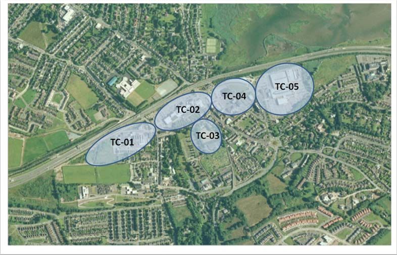
These areas are shown on the aerial photograph below.
- southwestern area for Proposed 1.4.39. The masterplan called for under zoning X-01 for the
residential (Student Village) use, Cork Science, Innovation Park will be brought before Council for
approval in September 2011.
- existing Open Space (Dog Track).
1.4.40. In the interim, while the masterplan for the Science,
Innovation Park is being prepared, proposals for development
1.4.31. The masterplan called for under zoning X-01 will reflect within the X-01 boundary should be processed using the 2005
the potential for early phasing of the previously zoned X-01 lands Carrigaline Electoral Area Local Area Plan land use zonings as
under the 2005 Carrigaline Electoral Area Local Area Plan. read with the guidance from section 1 of this Local Area Plan and
other objectives of this plan.
1.4.32. The above zoning also identified within the X-01 site a
proposed C.I.T Access Road, proposed Amenity Walk / Cycle Douglas
U
Route, proposed Park Access Road and proposed Access Point.
1.4.41. The Douglas Landuse and Transportation Study (LUTS)
1.4.33. As per the 2003 CDP, under the Cork County has concentrated on two clearly defined areas, X-03(a) and X-
Development Plan 2009, the northern portion of the CSIP subject 03(b). As indicated on the accompanied zoning map for the area,
site is identified as Metropolitan Cork Green Belt land. X-03(a) refers to lands at Douglas village while X-03(b) refers to
Douglas Town Centre Areas
lands at the existing Douglas Golf course development. Both
1.4.34. The CSIP as proposed will update and expand into the areas are governed by a single specific zoning objective.
1.4.45. In terms of priority for the development of retail, the
Metropolitan Cork Green Belt the existing zonings as set out in Douglas LUTS identified the need to, in the short term, fill existing
the Carrigaline Electoral Area Local Area Plan 2005. The 1.4.42. DLUTS has recommended that the X-03b zone be
retained as an open space and recreation zone for use by the vacancy in the Douglas Village Shopping Centre (TC-02), East
proposed rezoning of this strategically important green belt area is Village/ Cinema Site (TC-04) and the Woollen Mills (TC-01) as
considered appropriate only on the basis of the critical role the Douglas Golf Course (see O-12). It resolved that if mixed use
urban development was permitted on this land, there would be shown inTable 1.10.
CSIP shall fulfil in the provision of an innovation led future
economic base for the region and nationally. Hence, the unique unacceptable traffic congestion generated in Douglastown centre
nature and function of the CSIP must be enshrined in specific and there would be a serious loss of amenity to the local
objectives of the expanded zoning. community.
1.4.43. The DLUTS identifies Special Policy Area X-03a as a Table 1.10: Retail Priority Areas
1.4.35. Existing vehicular access to the site is via the N25 from
the south. It is intended to develop a road access linking the District Centre in line with the requirements of the Retail Planning
existing access location with the CIT to the east. This roadway, in Guidelines (2012) and the draft Cork Metropolitan Joint Retail Retail Areas Priority Areas
conjunction with a transportation management plan, shall allow for Strategy (2013). Within this District Centre area, there is a mixture
access to the CSIP as well as an easing of traffic congestion and of retail, employment, residential, recreation and community uses.
Douglas LUTS has identified a number of town centre zonings that 1. In-filling existing vacancy TC-02, TC-01 and
parking in Bishopstown - particularly in the vicinity of the CIT.
are distinct precincts which have established retail uses, where TC-04
1.4.36. The existing no. 5 & no. 8 public bus routes, in mixed use development can and should take place. By 2022, it is
Primary Retail 2. Redevelopment of TC-04: Cinema Site
consultation with Bus Eireann, can be extended into the CSIP to recommended that at least 50% of current retail vacancy would be filled Area
allow for a high level of public transport provision to serve the and that support be given to the fulfilment of current retail 3. Redevelopment of TC-01: Woollen Mills
park. Furthermore, in the longer term, it is envisaged that the Bus commitments. It is forecast that by 2032, if the required transport
Rapid Transit (BRT) service shall traverse the site and thus create measures have been implemented, these precincts could accommodate 4. Redevelopment of TC-05: Douglas Court
a high quality rapid transportation link to serve the CSIP. an additional 175 residential units and up to 25,000m2 of mixed use
9You can also read