Nottinghamshire Minerals Plan HRA Screening Report - Nottinghamshire County Council
←
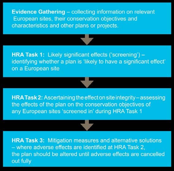
→
Page content transcription
If your browser does not render page correctly, please read the page content below

Nottinghamshire Minerals
Plan HRA Screening Report

Nottinghamshire County Council

1 March 2019
Quality information
Prepared by                        Checked by                       Verified by                 Approved by

George Wilkinson                   Dr James Riley                                               Dr Max Wade
Ecologist (Grad CIEEM)             Technical Director CEnv,                                     Technical Director CEcol,
GradCIEEM                          MCIEEM                                                       FCIEEM

Revision History
Revision              Revision date            Details            Authorized      Name                 Position

0                     01/03/19                 Draft  for   client JR             James Riley          Technical Director
                                               review

Distribution List
# Hard Copies         PDF Required             Association / Company Name

Prepared for: Nottinghamshire County Council                                                                        AECOM
                                                                                                                        2
Prepared for:
Nottinghamshire County Council
Prepared by:
AECOM Infrastructure & Environment UK Limited
Midpoint, Alencon Link
Basingstoke
Hampshire RG21 7PP
United Kingdom
T: +44(0)1256 310200
aecom.com
© 2019 AECOM Infrastructure & Environment UK Limited. All Rights Reserved.
This document has been prepared by AECOM Infrastructure & Environment UK Limited (“AECOM”) for sole use
of our client (the “Client”) in accordance with generally accepted consultancy principles, the budget for fees and
the terms of reference agreed between AECOM and the Client. Any information provided by third parties and
referred to herein has not been checked or verified by AECOM, unless otherwise expressly stated in the
document. No third party may rely upon this document without the prior and express written agreement of
AECOM.
Prepared for: Nottinghamshire County Council AECOM
3Table of Contents
1. Introduction ...................................................................................................... 5
Background to the Project ....................................................................................................................................... 5
Legislation ............................................................................................................................................................... 5
Report Structure ...................................................................................................................................................... 6
2. Methodology .................................................................................................... 7
Introduction ............................................................................................................................................................. 7
A Proportionate Assessment ................................................................................................................................... 7
The Process of HRA ............................................................................................................................................... 8
Physical Scope........................................................................................................................................................ 8
In Combination Scope ............................................................................................................................................. 9
Stage One: Likely Significant Effects Test (Screening).......................................................................................... 10
3. Pathways of Impact ........................................................................................11
Introduction ........................................................................................................................................................... 11
Direct Landtake ..................................................................................................................................................... 11
Disturbance ........................................................................................................................................................... 12
Air Quality ............................................................................................................................................................. 13
4. Likely Significant Effects Test ........................................................................ 16
Introduction ........................................................................................................................................................... 16
Direct Landtake ..................................................................................................................................................... 16
Disturbance ........................................................................................................................................................... 17
Air Quality ............................................................................................................................................................. 17
5. In Combination Effects................................................................................... 18
6. Recommendations for Sherwood ppSPA and minerals site Bestwood II ....... 20
European Sites...................................................................................................................................................... 20
Possible European Sites ....................................................................................................................................... 20
7. Conclusions ................................................................................................... 22
Appendix A European Sites Background .................................................................. 23
Birklands and Billaugh SAC .................................................................................................................................. 23
Hatfield Moor SAC and Thorne and Hatfield Moors SPA ...................................................................................... 25
Sherwood Possible pSPA...................................................................................................................................... 27
Appendix B Screening of Site Allocations................................................................. 29
Appendix C Map of Site Allocations and Relevant European Sites .......................... 31
Prepared for: Nottinghamshire County Council AECOM
41. Introduction
Background to the Project
1.1 AECOM was appointed by Nottinghamshire County Council to assist in undertaking Habitats Regulations
Assessment (HRA) of its Minerals Local Plan (hereafter referred to as the ‘Plan’). The objectives of the
assessment are to:
• Identify any aspects of the Plan that would cause a likely significant effect on any Natura 2000 sites,
otherwise known as European Sites, which include Special Areas of Conservation (SACs),
candidate SACs (cSACs), Special Protection Areas (SPAs) and potential SPAs (pSPAs) and as a
matter of Government policy, Ramsar sites, both in isolation and in combination with other plans
and projects; and
• Determine whether appropriate assessment (AA) would be required in order to identify potential
adverse effects on the integrity of any European sites.
Legislation
1.2 The need for Habitats Regulations Assessment is set out within Article 6 of the EC Habitats Directive
1992, and interpreted into British law by the Conservation of Habitats and Species Regulations 2017 (as
amended). The ultimate aim of the Directive is to “maintain or restore, at favourable conservation status,
natural habitats and species of wild fauna and flora of Community interest” (Habitats Directive, Article
2(2)). This aim relates to habitats and species rather than the European sites themselves, although the
sites have a significant role in delivering favourable conservation status.
1.3 The Habitats Directive applies the precautionary principle to European sites. Plans and projects can only
be permitted having ascertained that there will be no adverse effect on the integrity of the site(s) in
question. Plans and projects with predicted adverse effects on European sites may still be permitted if
there are no alternatives to them and there are Imperative Reasons of Overriding Public Interest (IROPI)
as to why they should proceed. In such cases, compensation would be necessary to ensure the overall
integrity of the site network.
1.4 In order to ascertain whether or not site integrity will be affected, a Habitats Regulations Assessment
should be undertaken of the plan or project in question:
Box 1. The legislative basis for appropriate assessment
Habitats Directive 1992
Article 6 (3) states that:
“Any plan or project not directly connected with or necessary to the management of the site but likely to have
a significant effect thereon, either individually or in combination with other plans or projects, shall be subject
to appropriate assessment of its implications for the site in view of the site's conservation objectives.”
Conservation of Habitats and Species Regulations 2017 (as amended)
The Regulations state that:
“A competent authority, before deciding to … give any consent for a plan or project which is likely to have a
significant effect on a European site … shall make an appropriate assessment of the implications for the site
in view of that site’s conservation objectives… The authority shall agree to the plan or project only after
having ascertained that it will not adversely affect the integrity of the European site.”
Prepared for: Nottinghamshire County Council AECOM
51.5 Over the years the phrase ‘Habitats Regulations Assessment’ has come into wide currency to describe the
overall process set out in the Conservation of Habitats and Species Regulations 2017 (as amended) from
screening through to IROPI. This has arisen in order to distinguish the process from the individual stage
described in the law as an ‘appropriate assessment’. Throughout this report we use the term Habitats
Regulations Assessment for the overall process.
1
1.6 In 2018, the ‘People Over Wind’ European Court of Justice (ECJ) ruling determined that ‘mitigation’ (i.e.
measures that are specifically introduced to avoid or reduce the harmful effects of a plan or project on
European sites) should not be taken into account when forming a view on likely significant effects.
Mitigation should instead only be considered at the appropriate assessment stage. Appropriate
assessment is not a technical term: it simply means ‘an assessment that is appropriate’ for the plan or
project in question. As such, the law purposely does not prescribe what it should consist of or how it
should be presented; these are decisions to be made on a case by case basis by the competent authority.
2
1.7 Also in 2018, the Holohan ECJ ruling was handed down. This determined that an HRA must catalogue
(i.e. list/identify) all the features for which a European site is designated. It also determined that a
European site must be considered within the context of its functional relationships in terms of a) whether
any interest features of the European site may be located outside the site boundary and could be affected
by the plan or project, and b) whether habitats and species for which the European site is not designated
are nonetheless fundamental to the ability of that site to achieve its conservation objectives and could be
affected by the plan or project. This HRA report considers those issues.
Report Structure
1.8 Section 2 of this report summarises the methodology for the assessment. Section 3 identifies the possible
pathways by which adverse effects on European sites could arise. Section 4 discusses the results of the
test of likely significant effects. Possible effects in combination with other relevant plans and documents
are examined in Section 5. Section 6 provides recommendations based on the outcome of screening, and
conclusions are detailed in Section 7. Background Information on the European sites discussed in this
report, including a catalogue of their interest features (as required by the Holohan ruling), is provided in
Appendix A. Full screening of site allocations undertaken in the likely significant effects test is included as
Appendix B. Appendix C presents a map of the European sites and site allocations assessed in this
report.
1
People Over Wind and Sweetman v Coillte Teoranta (C-323/17).
2
Case C-461/17.
Prepared for: Nottinghamshire County Council AECOM
62. Methodology
Introduction
2.1 This section sets out our approach and methodology for undertaking the HRA. Habitats Regulations
Assessment itself operates independently from the Planning Policy system, being a legal requirement of a
discrete Statutory Instrument.
A Proportionate Assessment
2.2 Project-related HRA often requires bespoke survey work and novel data generation in order to accurately
determine the significance of adverse effects. In other words, to look beyond the risk of an effect to a
justified prediction of the actual likely effect and to the development of avoidance or mitigation measures.
3
2.3 However, the draft MHCLG guidance makes it clear that when implementing HRA of land-use plans, the
HRA should be undertaken at a level of detail that is appropriate and proportional to the level of detail
provided within the plan itself:
2.4 ‘The comprehensiveness of the [appropriate] assessment work undertaken should be proportionate to the
geographical scope of the option and the nature and extent of any effects identified. An AA need not be
done in any more detail, or using more resources, than is useful for its purpose. It would be inappropriate
and impracticable to assess the effects [of a strategic land use plan] in the degree of detail that would
normally be required for the Environmental Impact Assessment (EIA) of a project.’
2.5 In other words, there is a tacit acceptance that appropriate assessment can be tiered and that all impacts
are not necessarily appropriate for consideration to the same degree of detail at all tiers (Box 2).
Box 2. Tiering in HRA of land use plans
2.6 For a land use plan, the level of detail concerning the developments that will be delivered is usually
insufficient to make a highly detailed assessment of the significance of effects. For example, precise and
full determination of the impacts and significant effects of a new settlement will require extensive details
concerning its design, including the layout of greenspace and type of development to be delivered in
particular locations, yet these data will not be finalised until subsequent stages.
3
CLG. (2006) Planning for the Protection of European Sites, Consultation Paper
Prepared for: Nottinghamshire County Council AECOM
74
2.7 On these occasions the advice of Advocate-General Kokott to the European Court of Justice is worth
considering. She commented that: “It would …hardly be proper to require a greater level of detail in
preceding plans [rather than planning applications] or the abolition of multi-stage planning and approval
procedures so that the assessment of implications can be concentrated on one point in the procedure.
Rather, adverse effects on areas of conservation must be assessed at every relevant stage of the
procedure to the extent possible on the basis of the precision of the plan. This assessment is to be
updated with increasing specificity in subsequent stages of the procedure” [emphasis added].
The Process of HRA
2.8 The HRA has been carried out in the continuing absence of formal Government guidance. CLG (now
5
MHCLG) released a consultation paper on the appropriate assessment of plans in 2006 . As yet, no
further formal guidance has emerged.
2.9 Box 3 below outlines the stages of HRA according to current draft MHCLG guidance. The stages are
essentially iterative, being revisited as necessary in response to more detailed information,
recommendation and any relevant changes to the plan until no significant adverse effects remain.
Box 3. Four-stage approach to HRA
2.10 In practice, this broad outline requires some amendment in order to feed into a developing land use plan.
The following process has been adopted for carrying out the HRA.
Physical Scope
2.11 The physical scope of the assessment (i.e. the range of European sites to be considered) is based on a
combination of tracing impact pathways and using distances derived from various studies.
2.12 The European sites of relevance to this HRA are shown in Table 1. Full details of reasons for their
designation (in accordance with the Holohan ruling), conservation objectives and key vulnerabilities are
presented in Appendix A. The locations of these European sites in relation to Nottinghamshire County are
presented in Figure 1.
4
Opinion of Advocate-General Kokott, 9th June 2005, Case C-6/04. Commission of the European Communities v United
Kingdom of Great Britain and Northern Ireland, paragraph 49.
http://curia.europa.eu/juris/document/document.jsf?docid=58359&doclang=EN
5
Ibid
Prepared for: Nottinghamshire County Council AECOM
8Table 1. European sites of relevance to HRA of the Plan
European site Site summary Proximity to
Nottinghamshire County
Birklands and Bilhaugh 270.5ha comprising old acidophilous oak woodland (the most Within County
SAC northerly site selected for this habitat).
Hatfield Moor Hatfield Moor SAC (overlaps Thorne and Hatfield Moors SPA) Approximately 2.7km north
SAC/Thorne and Hatfield covers 1359.5ha comprising various habitats, designated primarily
Moors SPA for its degraded raised bogs still capable of natural regeneration
Thorne and Hatfield Moors SPA consists of two moors covering a
combined 2449.2ha. The site is an extensive lowland raised mire
system, of particular interest for nightjar (Caprimulgus europaeus).
In addition, Nottinghamshire County contains the following possible pSPA (ppSPA) (Table 2).
Table 2. Possible European sites of relevance to HRA of the Plan
Possible European site Site summary Proximity to
Nottinghamshire County
Sherwood ppSPA A portion of the Sherwood Forest supporting significant Within County
populations of bird species of European importance; specifically
nightjar and woodlark (Lullula arborea).
Until the Sherwood Forest area is formally proposed by government as a pSPA there is no legal obligation to
undertake HRA of this site. However, if Sherwood ppSPA were to be formally proposed as a pSPA, plans and
projects would have to be subject by law to the provisions under the Conservation of Habitats and Species
Regulations 2017(as amended) that apply to assessment of impacts on all European sites. Natural England (NE)
still advises that in order to reduce future risks should the site ever be proposed, it is logical for Local Authorities
to satisfy themselves that current planning applications contain ‘sufficient objective information to ensure that all
potential impacts on the breeding nightjar and woodlark populations have been adequately avoided or
minimised’. In doing so, NE advises that this should be done ‘using appropriate measures and safeguards’, in
order to ‘ensure that any future need to review outstanding permissions under the 2010 Regulations is met with a
robust set of measures in place’ (letter from Natural England, 28 June 2010 updated July 2011, September 2012,
and March 2014).
In addressing the above, Natural England advises that local authorities take a ‘risk-based approach’ to forward
planning and decision making, such that, development plans and proposals are accompanied by an ‘additional
and robust assessment of the likely impacts arising from the proposals on any breeding nightjar and woodlark in
the Sherwood Forest area.’ It should be noted that the current possible boundary of the ppSPA may be subject to
change in the event that the site is designated.
In accordance with Natural England’s advice, as reinforced by the Secretary of State, an informal HRA screening
opinion is provided in this report. Caution should be placed on the fact that Sherwood Forest is not an SPA or a
pSPA (i.e. neither designated nor formally proposed for designation), such that the strict application of Regulation
105 is not required. Comments are provided, as best is possible, to address this alongside this HRA (particularly
in Section 6 of this report).
In Combination Scope
2.13 It is a requirement of the Conservation of Habitats and Species Regulations 2017 (as amended) that the
impacts and effects of any plan being assessed are not considered in isolation but ‘in combination’ with
other plans and projects that may also affect the European sites(s) in question.
2.14 In practice, in combination assessment is of greatest importance when the plan would otherwise be
screened out because the individual contribution is inconsequential. The principal other plans and projects
of relevance regarding in combination effects are:
Prepared for: Nottinghamshire County Council AECOM
9• Amber Valley Borough Draft Local Plan (2017);
• Anglian Water Revised Draft Water Resources Management Plan (2019);
• Ashfield Local Plan (2002); to be replaced by the Emerging Local Plan (withdrawn February
2018);
• Barnsley, Doncaster & Rotherham Joint Waste Plan (2012);
• Bassetlaw Draft Local Plan (2019);
• Bolsover District Local Plan (submitted 2018);
• Broxtowe Local Plan (2014);
• Central Lincolnshire Local Plan (2017);
• Charnwood Local Plan (2015);
• Doncaster Draft Local Plan (2018);
• Erewash Core Strategy (2014);
• Gedling Plan (2018);
• Mansfield District Local Plan Draft (2018);
• Melton Local Plan 2018;
• Newark and Sherwood Amended Core Strategy (2018) and Preferred Approach – ‘Sites and
Settlements’ and ‘Town Centres and Retail’ (2017);
• North Lincolnshire Local Plan (2003); to be replaced by the Local Development Framework;
• North West Leicestershire Local Plan (2017);
• Nottingham City Aligned Core Strategy (2014) and Local Plan Part 2 (submitted 2018);
• Rotherham Core Strategy (2014) an Site and Policies (2018);
• Rushcliffe Local Plan Part 1: Core Strategy (2014) and Local Plan Part 2: Land and Planning
Policies (currently under examination);
• Severn Trent Draft Water Resource Management Plan (2018); and
• South Kesteven Pre-submission Local Plan (2018).
Stage One: Likely Significant Effects Test
(Screening)
2.15 The first stage of any HRA is a likely significant effects (LSE) test. This is essentially a high level
assessment to decide whether the full subsequent stage known as appropriate assessment is required.
The essential question is:
‘Is the Plan, either alone or in combination with other relevant projects and plans, likely to result in a
significant effect upon European sites?’
2.16 The objective is to ‘screen out’ those plans and projects (or allocations/policies) that can, without any
detailed appraisal, be said to be unlikely to result in significant adverse effects upon European sites,
usually because there is no mechanism or pathway for an adverse interactions with European sites. This
stage is undertaken in Section 4 of this report.
2.17 It is important to determine the various ways in which a plan can affect European sites by following any
potential impact pathways from policies and site allocations. Briefly defined, pathways are routes by which
a change in activity associated with a policy can lead to an effect upon an internationally designated site.
2.18 In evaluating significance, AECOM has relied on professional judgement as well as the results of previous
stakeholder consultation regarding development impacts on the European sites considered within this
assessment.
Prepared for: Nottinghamshire County Council AECOM
103. Pathways of Impact
Introduction
3.1 When carrying out an HRA it is important to determine the various ways in which land use plans can affect
internationally designated sites. This means studying the pathways along which development can be
connected with internationally designated sites, in some cases many kilometres distant. Briefly defined,
pathways are routes by which a change in activity associated with a plan document or development can
lead to an effect upon an internationally designated site. Given that this plan will be delivering minerals
development, the following pathways have been identified as requiring further analysis in this HRA:
• Direct landtake;
• Disturbance; and
• Air quality
3.2 Minerals workings can also affect local water quality and flows/levels, both in terms of locally lowered
water tables through dewatering of excavations and in terms of sediment impacts on those watercourses
that receive the abstracted water when it is returned to the environment. However, none of the European
sites, or possible European sites, within Nottinghamshire is dependent on a high water table, or good
water quality. They are essentially dry, well-drained habitats. Hatfield Moor SAC is dependent on a locally
high water table, but is sufficiently far from the nearest site allocation, Bawtry Road West (approximately
8.7km south of the SAC) that minerals workings in Nottinghamshire will not affect this European site.
Direct Landtake
3.3 European sites and their supporting (‘functionally linked’) habitat are vulnerable to direct loss of land to
development. Loss of habitat is likely to have adverse impacts on populations of SPA bird species, which
depend on sufficiently large areas of suitable foraging and nesting habitat. A reduction in the area of
suitable habitat also increases the vulnerability of bird populations to other threats and pressures (e.g.
fires, changes in habitat structure).
3.4 Direct landtake is of particular concern regarding functionally linked habitat to European sites. Species for
which European sites may be designated will often also use habitat outside of the boundary of the
European site. As such, this habitat may be important to the long-term success of the European site’s
population of the species in question. Therefore where developments are proposed near to European
sites, it is necessary to assess the suitability of the site of the proposed development and adjacent
affected land to provide functionally linked habitat to the European site with respect to species for which
the European site is designated.
3.5 The requirement to consider potential effects on functionally linked habitat was recently reinforced by the
6
Holohan ruling . In the case of Nottinghamshire, the nature of Birklands & Bilhaugh SAC and Hatfield
Moor SAC means their ability to achieve their conservation objectives depends entirely on land within the
boundary of the SACs. With regard to Sherwood ppSPA and Thorne & Hatfield Moors SPA, the nightjar
and woodlark populations are heavily dependent on two habitats: rotationally managed plantation and
heathland/acid grassland. This HRA therefore considers the potential for impacts on these two habitats
even when present outside the ppSPA (or SPA) boundary.
7
3.6 In the case of plantation woodland, research undertaken in the Breckland Forest area has identified that
nightjar are most likely to use conventionally managed plantation during the first c. 20 years of the c. 60
year forestry cycle, including the initial 2 year ‘felled unplanted’ period. Population densities are highest
during the restock phase (plantation age of 0-5 years), although significant densities can also be
supported during the pre-thicket (6-10 years) and thicket (11 – 20 years) stages. The research also
identifies that woodlark are most likely to use conventionally managed plantation during its first seven
years (including the initial 2 year felled unplanted period), particularly the restock phase (plantation age of
6
Case C-461/17
7
Dolman PM & Morrison C, 2012. Temporal change in territory density and habitat quality for Breckland Forest SSSI woodlark
and nightjar populations, Unpublished report for Forestry Commission and Natural England.
Prepared for: Nottinghamshire County Council AECOM
110-5 years). They may also be found during the pre-thicket (6-10 years stage) but the density of woodlark
in pre-thicket plantation is very low.
3.7 Due to the fact that nightjar and woodlark only use the habitat during certain parts of the forestry cycle,
their absence from a given parcel of plantation, or the fact that the plantation is not in a suitable phase for
colonisation, at a given point in time cannot be used as a basis to conclude nightjar and woodlark will not
use the land. If the birds are known to be present in the broad area (as they are here) any conventionally
managed plantation could support them and its permanent loss would therefore reduce the overall
potential nesting resource available to both species.
Disturbance
3.8 Mineral extraction and quarrying activities within sites can have significant disturbance impacts on birds.
Disturbance can take many forms, including noise (e.g. from blasting/rock crushing (where undertaken),
vehicle movements), visual (e.g. from vehicle movements) and vibration (e.g. from blasting, where
undertaken).
3.9 Concern regarding the effects of disturbance on birds stems from the fact that they are expending energy
8
unnecessarily and the time they spend responding to disturbance is time that is not spent feeding .
Disturbance therefore risks increasing energetic output while reducing energetic input, which can
adversely affect the ‘condition’ and ultimately survival of the birds. In addition, displacement of birds from
one feeding site to others can increase the pressure on the resources available within the remaining sites,
9
as they have to sustain a greater number of birds . Moreover, the more time a breeding bird spends
disturbed from its nest, the more its eggs are likely to cool and the more vulnerable they are to predators.
3.10 Human activity can affect birds either directly (e.g. through causing them to flee, incurring an energetic
cost) or indirectly (e.g. through damaging their habitat). This can lead to behavioural changes (e.g.
alterations in feeding behaviour, avoidance of certain areas etc.) and physiological changes (e.g. an
increase in heart rate) that, although less noticeable, may ultimately result in major population-level effects
10
by altering the balance between immigration/birth and emigration/death .
3.11 Disturbing activities are on a continuum. The most disturbing activities are likely to be those that involve
irregular, infrequent, unpredictable loud noise events, movement or vibration of long duration. Birds are
least likely to be disturbed by activities that involve regular, frequent, predictable, quiet patterns of sound
or movement or minimal vibration. The further any activity is from the birds, the less likely it is to result in
disturbance.
3.12 The factors that influence a species’ response to a disturbance are numerous, but the three key factors
are species sensitivity, proximity of disturbance sources and timing/duration of the potentially disturbing
activity. The distance at which a species takes flight when approached by a disturbing stimulus is known
as the ‘tolerance distance’ (also called the ‘escape flight distance’) and differs between species to the
same stimulus and within a species to different stimuli.
11
3.13 There is usually no need for blasting at sand and gravel extraction sites but only at rock quarries. As
such, the noisiest typical activities associated with minerals extraction in Nottinghamshire are likely to be
noisy outdoor machinery and conveyors, which at their loudest is likely to produce noise levels below
100dB (A) at 1m from source. Noise in atmosphere attenuates by 6dB for every doubling in distance from
source. Therefore, even these noisiest activities are likely to result in noise levels below 70 dB at c. 100m
from source. This is relevant because research (primarily conducted on waterfowl but broadly transferable
to other bird species) indicates that birds typically exhibit a flight response at noise levels exceeding 84dB,
12
while at levels below 55 dB there is no effect. .These therefore define the two extremes. It is also
generally advised that an activity will not have disturbance effects on birds if the maximum noise level (at
13
the bird) is below 70dB .
8
Riddington, R. et al. 1996. The impact of disturbance on the behaviour and energy budgets of Brent geese. Bird Study
43:269-279
9
Gill, J.A., Sutherland, W.J. & Norris, K. 1998. The consequences of human disturbance for estuarine birds. RSPB
Conservation Review 12: 67-72
10
Riley, J. (2003) Review of Recreational Disturbance Research on Selected Wildlife in Scotland. Scottish Natural Heritage.
11
https://www.gov.scot/publications/blasting-surface-mineral/
12
Cutts N. & Allan J. (1999) Avifaunal Disturbance Assessment. Flood Defence Works: Saltend. Report to Environment
Agency.
13
Cutts, N., Phelps, A. & Burdon, D. (2009) Construction and waterfowl: Defining Sensitivity, Response, Impacts and Guidance.
Report to Humber INCA, Institute of Estuarine and Coastal Studies, University of Hull.
Prepared for: Nottinghamshire County Council AECOM
123.14 In addition to noise, there is also the possibility of visual disturbance and some species of bird are
understood to be sensitive to visual stimuli at considerable distances. Thorne and Hatfield Moors SPA and
Sherwood ppSPA are designated (or proposed for designation) for their features of ornithological interest:
14,15
specifically populations of nightjar and woodlark. Liley and Clarke found that the density of European
nightjar was directly related to the amount of surrounding development, with sites surrounded by higher
levels of development supporting fewer nightjars. The species’ breeding success appears to be much
16
higher at less visited sites , with path proximity correlating strongly with nest failure up to 225m from the
path edge. Research suggests that within heathland nightjars typically do not settle within 250-500m of
17
development land , although there are exceptions to this situation. Similarly, woodlark is affected by
disturbance. Mallord estimated that, for 16 sites in southern England, 34% more woodlark chicks would be
18,19
raised if all sites were free from disturbance . The disturbance effect on these species is, however,
likely to be strongly associated with the presence of dogs which are perceived as predators by sensitive
ground-nesting birds. Clearly, recreational activity generally and dog walking in particular will not be
associated with minerals development.
3.15 Given this, it is considered that a sufficiently cautious distance to use in this HRA is to assume that
extraction and quarrying activities might result in disturbance to nightjar and woodlark where they occur
within 500m of the bird population in question. In practice it is expected that this distance is highly
precautionary.
Air Quality
3.16 Mineral extraction and quarrying activities have the potential for air quality impacts on European sites,
both by increasing levels of pollutants (e.g. through increased vehicle use) and through the spread of dust.
Nitrogen deposition
3.17 Other than dust, the main pollutants of concern for European sites are oxides of nitrogen (NOx), ammonia
(NH3) and sulphur dioxide (SO2). Ammonia can be directly toxic to vegetation, and research suggests that
this may also be true for NOx at very high concentrations. More significantly, greater NOx or ammonia
concentrations within the atmosphere lead to greater rates of nitrogen deposition to vegetation and soils.
An increase in the deposition of nitrogen from the atmosphere is generally regarded to increase soil
fertility, which can have a serious deleterious effect on the quality of semi-natural, nitrogen-limited
terrestrial habitats. Further information on the sources and effects of air pollutants is provided in Table 3.
Table 3. Main sources and effects of air pollutants on habitats and species
Pollutant Source Effects on habitats and species
Acid SO2, NOx and ammonia all contribute to acid Can affect habitats and species through both wet (acid
deposition deposition. Although future trends in SO2 rain) and dry deposition. Some sites will be more at risk
emissions and subsequent deposition to than others depending on soil type, bed rock geology,
terrestrial and aquatic ecosystems will weathering rate and buffering capacity.
continue to decline, it is likely that increased
NOx emissions may cancel out any gains
produced by reduced SO2 levels.
Ammonia Ammonia is released following decomposition Adverse effects are as a result of nitrogen deposition
(NH3) and volatilisation of animal wastes. It is a leading to eutrophication. As emissions mostly occur at
naturally occurring trace gas, but levels have ground level in the rural environment and NH3 is
increased considerably with the expansion in deposited rapidly, some of the most acute problems of
agricultural livestock numbers. Ammonia NH3 deposition are for small relict nature reserves
reacts with acid pollutants such as the located in intensive agricultural landscapes.
products of SO2 and NOX emissions to
14
Liley, D. & Clarke, R.T. (2003) The impact of urban development and human disturbance on the numbers of nightjar
Caprimulgus europaeus on heathlands in Dorset, England. Biological Conservation, 114: 219-230.
15
Liley, D. & Clarke, R.T. (2002) The impact of human disturbance and human development on key heathland bird species in
Dorset. Sixth National Conference (eds Underhill, J.C. & Liley, D.). RSPB, Bournemouth.
16
Murison, G. (2002) The Impact of Human Disturbance on the Breeding Success of the Nightjar Caprimulgus europaeus on
Heathlands in South Dorset, England. English Nature.
17
Liley, D & Clarke, R.T. 2003. The impact of urban development and human disturbance on the numbers of nightjar
Caprimulgus europaeus on heathlands in Dorset, England. Biological Conservation 114: 219-230.
18
Mallord, J. (2005) Predicting the consequences of human disturbance, urbanisation and fragmentation for a woodlark Lullula
arborea population. PhD Thesis, University of East Anglia, Norwich, UK.
19
Liley, D. (2005) A summary of the evidence base for disturbance effects to Annex 1 bird species on the Thames Basin
Heaths & research on human access patterns to heathlands in southern England. Footprint Ecology/English Nature.
Prepared for: Nottinghamshire County Council AECOM
13produce fine ammonium (NH4+) - containing
aerosol which may be transferred much longer
distances (and can therefore be a significant
trans-boundary issue).
Nitrogen Nitrogen oxides are mostly produced in Deposition of nitrogen compounds (e.g. nitrates (NO3),
oxides (NOx) combustion processes. About one quarter of nitrogen dioxide (NO2) and nitric acid (HNO3)) can lead
the UK’s emissions are from power stations, to soil and freshwater acidification. In addition, NOx can
one half from motor vehicles, and the rest from cause eutrophication of soils and water. This alters the
other industrial and domestic combustion species composition of plant communities and can
processes. eliminate sensitive species.
Nitrogen (N) The pollutants that contribute to nitrogen Species-rich plant communities with relatively high
deposition deposition derive mainly from NOX and NH3 proportions of slow-growing perennial species and
emissions. These pollutants cause acidification bryophytes are most at risk from nitrogen
(see also acid deposition) as well as eutrophication, due to its promotion of competitive and
eutrophication. invasive species which can respond readily to elevated
nitrogen levels. Nitrogen deposition can also increase
the risk of damage from abiotic factors (e.g. drought,
frost).
Ozone (O3) A secondary pollutant generated by Concentrations of O3 above 40ppb can be toxic to
photochemical reactions from NOx and volatile humans and wildlife and can affect buildings. Increased
organic compounds (VOCs). These are ozone concentrations may lead to a reduction in growth
mainly released by the combustion of fossil of agricultural crops, decreased forest production and
fuels. The increased combustion of fossil fuels altered species composition in semi-natural plant
in the UK has led to a large rise in background communities.
ozone concentration, increasing the number of
days when levels across the region are above
40ppb. Reducing ozone pollution is believed to
require action at an international level to
reduce levels of the precursors that form
ozone.
Sulphur Main sources of SO2 emissions are electricity Wet and dry deposition of SO2 acidifies soils and
dioxide generation, industry and domestic fuel freshwater, and alters the species compositions of plant
(SO2) combustion. May also arise from shipping and and associated animal communities. The significance of
increased atmospheric concentrations in busy impacts depends deposition levels and the buffering
ports. Total SO2 emissions have decreased capacity of soils.
substantially in the UK since the 1980s.
3.18 Sulphur dioxide emissions are overwhelmingly influenced by the output of power stations and industrial
processes that require the combustion of coal and oil. Ammonia emissions are dominated by agriculture,
with some chemical processes also making notable contributions. However, emissions of nitrogen oxides
are dominated by the output of vehicle exhausts, while diesel generators associated with some mineral
activities will also emit NOx. Emissions of nitrogen oxides could therefore be reasonably expected to be
associated with any increase in net vehicle movements as an indirect effect of the Plan.
3.19 According to the Department of Transport’s Transport Analysis Guidance, “beyond 200m, the contribution
20
of vehicle emissions from the roadside to local pollution levels is not significant” . This distance has
therefore been used in this HRA to determine whether European sites are likely to be significantly affected
by Plan site allocations (Figure 2).
Figure 2. Traffic contribution to pollutant concentrations in relation to the distance from a road (DfT)
20
www.webtag.org.uk/archive/feb04/pdf/feb04-333/pdf
Prepared for: Nottinghamshire County Council AECOM
143.20 According to the World Health Organisation, the critical NOx concentration (critical threshold) for the
-3 -3
protection of vegetation is 30 µgm ; the threshold for sulphur dioxide is 20 µgm . In addition, ecological
21
studies have determined ‘critical loads’ of atmospheric nitrogen deposition (that is, NOx combined with
ammonia NH3).
3.21 This assessment therefore considers the effects of traffic movements on European sites where a minerals
site may be associated with a net increase in annual average daily traffic (AADT) within 200m of a
sensitive European site (primarily Birklands & Bilhaugh SAC) including the strategic road network. At the
same time, it must be borne in mind that a minerals site allocation may be associated with the extension in
years of operation for an existing minerals site, rather than a net increase in minerals extraction activity
and thus may not be associated with any forecast net change in AADT.
Dust
3.22 Atmospheric pollutants generated by minerals sites also include dust emissions. The effects of dust will
depend on the prevailing wind direction, and the transport distance is related to particle size. Dust particle
size and chemical composition is important as smaller particles can enter or block stomata and thus
interfere with gas exchange, while sufficient coverage may prevent light penetration to the chloroplasts. In
prolonged cases, death can result.
3.23 In the absence of control measures, dust generation is most likely to occur during soil stripping (and from
wind blow of associated spoil heaps), extraction or rock blasting, screening, crushing, track out and
operation of conveyors. It may also occur during soil manipulation as part of site restoration. For the
22
purposes of screening, according to guidance from the Institute of Air Quality Management , with respect
to possible effects due to dust, “an assessment will normally be required where there is…an ‘ecological
receptor’ within: 50m of the boundary of the site; or 50m of the route(s) used by construction vehicles on
the public highway, up to 500m from the site entrance(s)”. Site allocations that lie more than 50m from the
European site and do not have scope for large scale production of dust have therefore been ‘screened
out’ as being unlikely to contribute significant dust impacts, even without special mitigation such as
‘wetting’.
21
The critical load is the rate of deposition beyond which research indicates that adverse effects can reasonably be expected to
occur.
22
IAQM. (2016) Guidance on the assessment of dust from demolition and construction. The Institute of Air Quality
Management. Version 1.1.
Prepared for: Nottinghamshire County Council AECOM
154. Likely Significant Effects Test
Introduction
4.1 The Plan includes the following minerals allocations, which require screening to determine if there is
potential for likely significant effects on European sites (the locations of which are shown in Figure 1):
• Bawtry Road West;
• Scrooby Thompson Land;
• Scrooby North;
• Langford Lowfields North;
• Besthorpe East;
• Mill Hill near Barton in Fabis;
• Bestwood II North;
• Scrooby Top North; and
• Bantycock South.
4.2 Based on the impact pathways discussed in Section 3, the following European sites (including possible
European sites) and impact pathways have been identified as being relevant to this assessment, in
combination with other plans and projects:
• Birklands and Bilhaugh SAC: this European site would be vulnerable to air quality impacts from
increased vehicle traffic on roads within 200m and activities producing dust (e.g. mineral
extraction, quarrying) within 50m of the site.
• Hatfield Moor SAC/Thorne and Hatfield Moors SPA: this European site would be vulnerable to air
quality impacts from increased vehicle traffic on roads within 200m and activities producing dust
(e.g. mineral extraction, quarrying) within 50m of the site. The nightjar population for which the
SPA is designated is potentially vulnerable to disturbance (particularly noise and visual
disturbance) from activities within 500m of the site. These vulnerabilities also apply to functionally
linked habitat to Thorne and Hatfield Moors SPA, which may be used by this nightjar population.
• Sherwood ppSPA: this possible European site would be vulnerable to disturbance (particularly
noise and visual disturbance) from activities within 500m of the site, which could negatively affect
nightjar and woodlark populations. The habitats supporting these species (plantation woodland)
may also be susceptible to changes in vegetation structure resulting from air quality impacts due
to increased vehicle traffic on roads within 200m of the site, or from activities producing dust (e.g.
mineral extraction, quarrying) within 50m of the site. These vulnerabilities also apply to
functionally linked habitat to the European site, which may be used by these nightjar and
woodlark populations.
Direct Landtake
4.3 None of the nine site allocations will occur within land covered by a European designation, or in habitat
that is functionally linked to any European sites. With respect to possible European sites, one site
allocation has potential for indirect likely significant effects on Sherwood ppSPA:
• Bestwood II North – this site is approximately 800m west of the possible European site. This site
allocation is for extension of the existing Tarmac Bestwood II Quarry: specifically a northern
extension in which approximately 750,000 tonnes of sandstone will be excavated over a 6 year
period. The extension at Bestwood II North will take place within Longdale Plantation. Plantation
woodland is a favoured habitat for nightjar and woodlark (for which Sherwood ppSPA is proposed
for designation). The land in which the Bestwood II North extension will take place could
therefore comprise functionally linked habitat to the ppSPA, in which case this site allocation
could result in direct landtake (i.e. habitat loss) of functionally linked habitat to the ppSPA.
Prepared for: Nottinghamshire County Council AECOM
164.4 Whilst there is no legal obligation to conduct an HRA of the potential for adverse effects on possible (as
opposed to formally proposed or officially designated) European sites, Natural England advises that local
authorities take a ‘risk-based approach’ to forward planning and decision making, such that development
plans and proposals are accompanied by an ‘additional and robust assessment of the likely impacts
arising from the proposals on any breeding nightjar and woodlark in the Sherwood Forest area’. It should
be noted that the People over Wind ECJ ruling mentioned earlier (prohibiting the consideration of
mitigation in the screening stage of HRA) does not apply to Sherwood ppSPA because this site is not an
SPA (or even a formally proposed SPA). Therefore, mitigation recommendations with respect to possible
loss of functionally linked land for Sherwood ppSPA are made in Section 6.
Disturbance
4.5 None of the nine site allocations have potential for likely significant effects on European sites through
disturbance due to their distance. All site allocations are far in excess of 500m from any European sites.
As such, disturbance effects on European sites can be screened out. With respect to possible European
sites, one site allocation has potential for likely significant effects on Sherwood ppSPA:
• Bestwood II North – approximately 800m west of the possible European site (see site allocation
description in Subsection 4.4 above). The 800m distance far exceeds that over which
disturbance impacts can be reasonably expected to occur, even using the highly precautionary
500m screening distance in this HRA. However, as discussed in Subsection 4.4, land in which
the extension at Bestwood II North will take place consists of plantation woodland (‘Longdale
Plantation’), which may comprise functionally linked habitat to the ppSPA such that any nightjar
and woodlark nesting within c. 100m of the quarry at the time the extension is being worked
could be displaced elsewhere.
4.6 Recommendations with respect to possible disturbance impacts on Sherwood ppSPA are made in Section
6.
Air Quality
4.7 None of the European sites are located within 200m of any of the allocated minerals sites or within 200m
of roads that are likely to experience an increase in traffic as a result of proposed extraction and quarrying
activities. Hatfield Moor SAC is well over 300m from the nearest A road (the A614). The only road within
200m of Birklands & Bilhaugh SAC is Swinecote Road (B6034) located in the town of Edwinstowe in
Newark and Sherwood District. This is a minor road remote from any of the minerals sites and will not
constitute a route for minerals traffic. While parts of the Sherwood ppSPA are within 200m of major roads
(such as the A617 in the Mansfield area), all of the allocated sites constitute sequential spatial/temporal
extensions to existing minerals operations that will not be worked until the current resource is exhausted.
As such, they are unlikely to be associated with a net increase in minerals traffic compared to current
levels.
4.8 None of the nine site allocations are within 50m of a European site. Therefore, air quality impacts relating
to dust are not anticipated. As such, air quality impacts on European sites can be screened out. With
respect to possible European sites, one site allocation has potential for likely significant effects on
Sherwood ppSPA:
• Bestwood II North – approximately 800m west of the possible European site (see site allocation
description in Subsection 4.4 above). As the site allocation is over 50m from the ppSPA possible
air quality impacts on the possible European site due to dust can be screened out at this stage.
However, as discussed in Subsection 4.4 above, the Bestwood II North extension is proposed to
take place within Longdale Plantation, which comprise functionally linked habitat to the ppSPA for
nightjar and woodlark. Air quality impacts on this habitat due to dust cannot be screened out.
4.9 Recommendations with respect to possible air quality impacts on Sherwood ppSPA are made in Section
6.
Prepared for: Nottinghamshire County Council AECOM
175. In Combination Effects
5.1 It is a requirement of the Conservation of Habitats and Species Regulations 2017 (as amended) that the
impacts and effects of any plan being assessed are not considered in isolation but ‘in combination’ with
other plans and projects that may also affect the European sites(s) in question.
5.2 The local plans for the following districts overlap with the Sherwood possible SPA or associated
plantations and areas of acid grassland: Mansfield, Newark & Sherwood, Ashfield and Bassetlaw. They
propose the delivery of housing and employment land over a period leading up to approximately 2033.
Delivery of housing in particular could lead to increased recreational pressure on the accessible parts of
the Sherwood possible SPA. However, all four local plans have undertaken HRAs which consider impacts
on the possible SPA from recreational pressure, and all conclude no adverse effect on integrity due to a
combination of measures that all the authorities are introducing.
5.3 The Sherwood Forest Country Park is the part of the possible SPA most likely to receive additional visitors
due to population growth. The Country Park is taking measures to plan for the expected increase in visitor
numbers, and also to help deliver the vision of a proposed Sherwood Regional Park. The recent relocation
of the Sherwood Forest Visitor Centre is itself expected to result in an increase in visitors to the Country
Park, which is compared to current visitor numbers of approximately 350,000. The planned visitor centre
will include a number of new attractions and increased visitor facilities.
5.4 The Sherwood Forest Living Legends project informs plans for a proposed Sherwood Forest Regional
Park. The HRA report for the Sherwood Living Legend project, which included plans for the relocation of
the visitor's centre, found no likely significant effect associated with this planned development. The key
conclusions were that existing paths and visitor facilities have the ability to cope with some further visitor
numbers, but also, improvements are proposed to the management of paths and to visitor management in
order to ensure no likely significant effect.
5.5 The Sherwood Forest Country Park is located within Newark and Sherwood District. Newark and
Sherwood District Council's HRA of the Newark & Sherwood Amended Core Strategy (June 2018)
concluded that new residential development at all settlements with Newark and Sherwood District would
have the potential for cumulative impact on the possible SPA, due to proximity of development (within
20km) of the site and its popularity with visitors. New policy wording was devised to enable mitigation to
be delivered. This wording was included in both the Core Strategy and Development Management plans
and through wording in relation to specific allocations. The main purpose of these policies has been to
ensure that there is adequate provision of Suitable Alternative Natural Greenspace (SANGs) in Newark
and Sherwood District (Policy DM7 and Core Policy 12). As a result, the latest HRA of the Newark &
Sherwood Amended Core Strategy concluded that "due to the landscapes surrounding the district,
including green infrastructure, open space and woodland, these 'should help to offset increases in
recreational pressures on the [possible SPA] as well as Birkland & Bilhaugh SAC'.".
5.6 The Ashfield District Council Local Plan went through examination in 2017 and has Main Modifications
Consultation in 2018. The HRA of the local plan (2016) identifies the large amounts of alternative
recreational natural greenspace already existing in Ashfield District (other than the possible SPA) and
concludes that "Even in light of a potential increase in visitors to the [possible SPA], it is considered that
the existing raft of management initiatives referred to above and the relocation of the visitors centre in
Sherwood Forest will be sufficient to avoid a significant effect on the [possible SPA] in the foreseeable
future, and in any event within the life of the Local Plan." Paragraph 1.9 of Ashfield District Council's
written statement regarding Matter 1 of the examination made it clear that the local plan was considered
not to have a likely significant effect on the Sherwood possible SPA and that Natural England concurred
with that conclusion. Although the Ashfield Local Plan has since been withdrawn from examination with a
view to preparing a new local plan, this was not due to considerations regarding the Sherwood possible
SPA.
5.7 Mansfield District Council identified in their HRA the need for the following components to address
recreational pressure on the possible SPA (and land supporting nightjar and woodlark lying beyond the
possible SPA):
• improving (and promoting) natural green space nearby;
Prepared for: Nottinghamshire County Council AECOM
18You can also read