Thompson Rivers Natural Resource District Off-Road Vehicle Recreation Strategy - Recommendation Paper
←
→
Page content transcription
If your browser does not render page correctly, please read the page content below
Thompson Rivers Natural Resource District
Off-Road Vehicle Recreation Strategy –
Recommendation Paper

March 30, 2015
This report was prepared by:

Thompson Rivers Natural Resource District Off-road Vehicle Recreation Strategy
Steering Committee:

Amy Tipler           Land and Resource Management Specialist, Thompson Okanagan Region, Ministry of
                     Forests, Lands and Natural Resource Operations (MFLNR)

Noelle Kekula        Recreation Officer, Recreation Sites and Trails BC, Thompson Rivers Natural Resource
                     District, Ministry of Forests, Lands and Natural Resource Operations (MFLNR)

Sheryl Wurtz         Range Officer, Thompson Rivers Natural Resource District, Ministry of Forests, Lands and
                     Natural Resource Operations (MFLNR)

Shauna Jones         Ecosystems Biologist, Thompson Okanagan Region, Ministry of Forests, Lands and
                     Natural Resource Operations (MFLNR)

John Hanemaayer      Stewardship Technician, Thompson Rivers Natural Resource District, Ministry of Forests,
                     Lands and Natural Resource Operations (MFLNR)

Corinne Bexson       Geomatics Technician, Thompson Rivers Natural Resource District, Ministry of Forests,
                     Lands and Natural Resource Operations (MFLNR)

Amanda Weber-Roy Area Supervisor, BC Parks, Ministry of Environment (MoE)

Mike Anderson        Natural Resource Manager, Skeetchestn Indian Band

Carrie Dan           Sr. Archaeologist/Culture Heritage Manager, Tk’emlups te Secwepemc

                                                                                                               2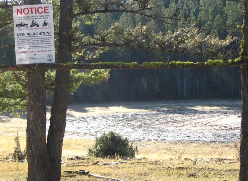
Table of Contents

1.0       Introduction .................................................................................................................................................5
   Project Scope ........................................................................................................................................................5
   Report Structure ...................................................................................................................................................6
2.0       Background ..................................................................................................................................................6
3.0       Methodology ................................................................................................................................................8
   Issues list and background research.................................................................................................................. 10
   Stakeholder Consultation Process ..................................................................................................................... 11
   First Nations Consultation ................................................................................................................................. 11
   Mapping............................................................................................................................................................. 11
4.0 Current Situation and Issues........................................................................................................................... 12
   Situational Analysis ............................................................................................................................................ 12
   4.1 Environmental Damage ............................................................................................................................... 15
   4.2 Disturbance to Wildlife and damage to Wildlife Habitat ............................................................................ 16
   4.3 Crown land Grazing ..................................................................................................................................... 17
   4.4 Public Health/Safety .................................................................................................................................... 18
   4.5 Wildfire Risk ................................................................................................................................................. 19
   4.6 Invasive Species ........................................................................................................................................... 20
   4.7 Dispersed camping ...................................................................................................................................... 21
   4.8 Large Events and Gatherings (parties)......................................................................................................... 22
5.0 Criteria and Evaluation ................................................................................................................................... 23
   5.1 Concept Lafarge ORV use area .................................................................................................................... 24
   5.2 Concept of improvement and trail plan for existing Batchelor Motorized Recreation area ...................... 25
   5.3 Concept of Noble ORV trail network ........................................................................................................... 25
   5.4 Concept of FRPA Section 58 motorized closure for lower Noble area ........................................................ 26
   5.5 Concept of Scuitto Lake Recreation Site ..................................................................................................... 26
   5.6 Concept of Chuwhels mountain ORV trail network .................................................................................... 26
   5.7 Concept of FRPA section 58 for Miller Pond area ....................................................................................... 27
   5.8 Concept of FRPA section 58 for Barnhartvale/Scuitto area ........................................................................ 27
6.0 Recommendations .......................................................................................................................................... 28

                                                                                                                                                                        3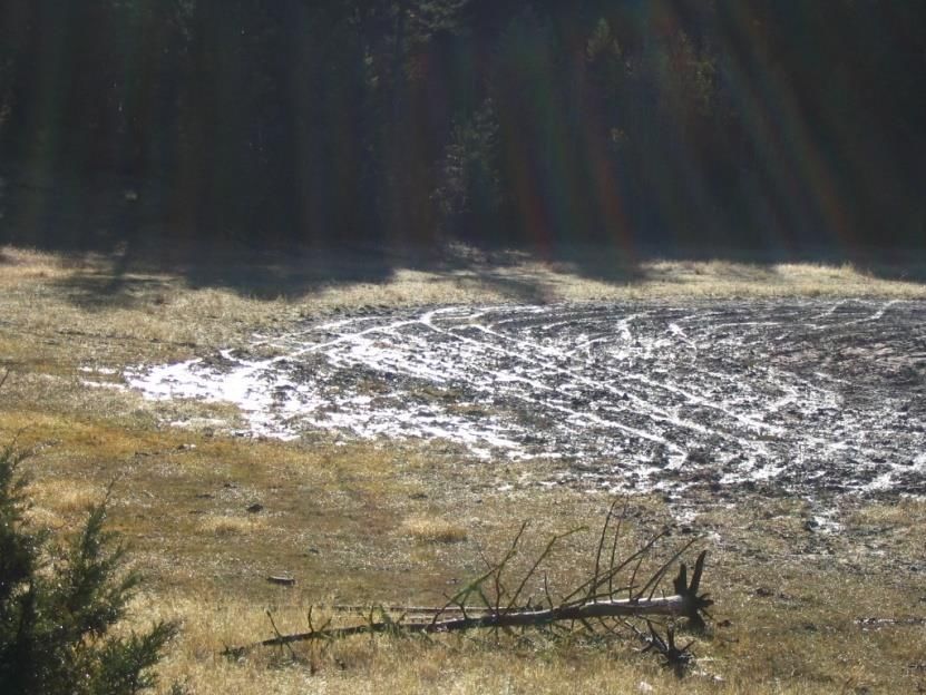
Appendix One: Thompson Rivers Natural Resource District Map......................................................................... 33
Appendix Two: List of Abbreviations and Acronyms ............................................................................................. 34
Appendix Three: Grazing Lease/ORV Fact Sheet ................................................................................................... 35
Appendix Four: Case Studies ................................................................................................................................. 36
Appendix Five: Issues Map .................................................................................................................................... 39
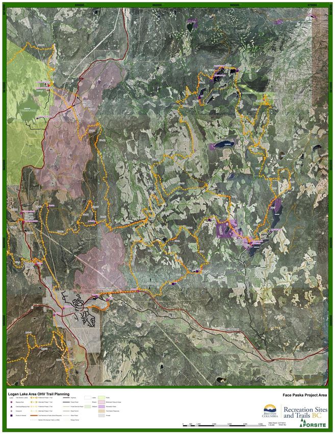
Appendix Six: Logan Lake Area OHV Trail Plan ...................................................................................................... 41
4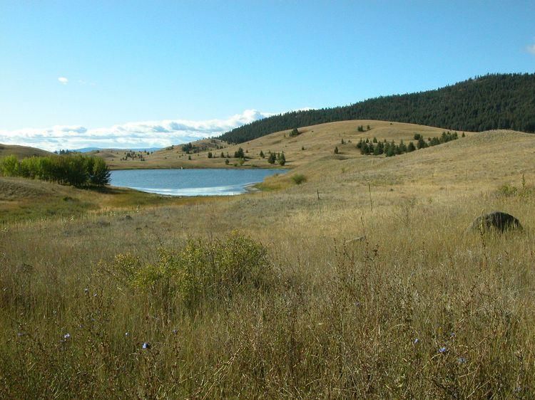
1.0 Introduction
Motorized recreation use in the Thompson Rivers Natural Resource District (TRNRD) has increased in the past
few years, and so has the impact to Crown land values and the conflicts between user groups. Motorized
recreation for this report is defined as the use of off road vehicles on Crown land for recreational purposes
including hunting. Off-road vehicles (ORV) are defined in the Off-Road Vehicle Act as all-terrain vehicles (aka
“quads”), off-road motorcycles (i.e. dirt bikes), side-by-sides (e.g. “Rhinos” and “Razors”) and snowmobiles
(though out of scope for this report). A strategic planning process was initiated in early 2014 to ensure that the
cumulative effects of ORV activities (in particular ORV use and dispersed camping) on sensitive values are
managed. The intent was that a strategic approach to ORV activities would result in conflicts being reduced,
public safety increased while environmental values are maintained. The plan will consider opportunities to
enhance, integrate and balance ORV activities with the need to protect Crown land values.

The recommendation paper was prepared by the Thompson Rivers Natural Resource District Off-Road Vehicle
Recreation Strategy Steering Committee which consisted of; Amy Tipler (Planning, MFLNR), Noelle Kekula
(Recreation, Sites and Trails BC, MFLNR), Sheryl Wurtz (Range, MFLNR), John Hanemaayer (Silviculture,
MFLNR), Corinne Bexson (Geospatial Services, MFLNR), Shauna Jones (Ecosystems, MFLNR), Amanda Weber-
Roy (BC Parks), Carrie Dan (T’kemlups) and Mike Anderson (Skeetchestn).

The specific objective is to outline implementation steps to address motorized recreation management issues
and to make recommendations to the statutory decision makers supporting the protection of sensitive
resource values on Crown land while maintaining opportunities for respectful ORV use. This paper focusses on
ORV recreational activities; there is recognition that there are other activities on Crown land that also
contribute to impacts to environmental values but those will not be dealt with in this paper.

Many values will continue to be at risk and potentially impacted without some measure of recreation and other
land use management being established in the TRNRD. Management efforts need to focus on protecting
Crown land values while providing for the increasing demand for safe recreational opportunities.

The development of an overall ORV strategic plan for the TRNRD will not only reduce conflicts and protect the
environment, but will also allow the district to be more proactive in managing land use and provide
stakeholders and First Nations with a better understanding of the management objectives for Crown lands.
With growing demands on a shrinking land base, the privilege of using Crown land needs to be clearly
identified, respected and managed in a manner that prevents cumulative environmental degradation and
maintains public safety.

Project Scope
The TRNRD is dedicated to the management and conservation of resource values for more than 2,769,417
hectares of Crown land. 1,057,000 ha of which are Crown range and 69,286 ha of Crown land within grazing
leases. Sensitive ecosystems such as grasslands, wetlands, and open forest are impacted by unregulated ORV
activity with the creation of unauthorized trails in the TRNRD. Today, grasslands cover less than one percent of
British Columbia’s land area and are one of Canada’s most endangered ecosystems. Although grasslands cover
a very small portion of British Columbia’s land area, they provide habitat for many of the province’s rare and
endangered species.

                                                                                                                5
For a map of the TRNRD, see Appendix One. The project scope includes only the Crown lands within the
TRNRD.
This project aims to protect sensitive resource values while managing public motorized recreation access and
ensuring authorized off-road vehicle trails in the TRNRD are designed, developed and maintained to be
sustainable. The recommendations provided are limited to Crown land recreation activities, primarily off-road
vehicle use and specifically for wheeled off-road vehicles (motorbikes, all-terrain vehicles, and side by sides),
though there are some anomalies. Snowmobiles are out of scope for these recommendations.
Prior to investigating the ORV issues within the TRNRD, the assumption was that the majority of the damage
occurring was a result of all-terrain vehicles (ATV) and off-road motorbikes, however it has become apparent
that a lot of the damage to the environment is also being caused by 4x4 vehicles. Furthermore, through
consultation it has become evident that the majority of ORV damage is due to a minority of irresponsible and
uneducated ORV and 4x4 users.
Report Structure
The report is structured as follows:
Section two outlines background of the situation;
Section three outlines project methodology;
Section four discusses current situation and issues;
Section five is the criteria and evaluation of proposed solutions/options; and
Section six provides recommendations/approaches to mitigate the most significant ORV conflicts that
the Thompson Rivers Natural Resource District has been experiencing.
A list of abbreviations and acronyms is provided in Appendix Two.
2.0 Background
Voluntary registration for off-road vehicles began on November 17, 2014. Prior to the voluntary registration
there was no form of registration in place for ORV users. On June 1, 2015 it will be mandatory to register off-
road vehicles for use on Crown land. The Off-road Vehicle Act was passed on March 24, 2014, which supports
the Province’s Off-road Vehicle Management Framework. The framework will help British Columbians get out
and enjoy the beauty of the province’s backcountry and ensure off-road vehicles are driven in a safe and
environmentally responsible manner.
The TRNRD has a history of unrestricted ORV use and this use is ongoing. This has led to a variety of
undesirable impacts, which in the absence of strategic direction are likely to continue and increase as
popularity in ORVs continues to grow. Since the Off-Road Vehicle Act is very new and traditionally BC has had
no ORV legislation, BC has attracted many residents and non-residents for unregulated ORV use. Numerous
complaints related to unauthorized ORV activities are received annually, many of which are significant,
especially in the vicinity of population centres and in low elevation areas with less snow accumulation. Many of
the lower elevation grasslands within the TRNRD have Crown land range leases on them which are coinciding
6with ORV use. Impacts include damage to sensitive plant communities, wetlands and riparian areas, soil
compaction and erosion, and the spread of invasive plant species. Dispersed camping and campfire issues have
also been noted in some of the more popular areas. RCMP and the Conservation Officer Service (COS) have
been called on numerous occasions to manage firearm and burning offences. Other common issues include
unauthorized ORV trail networks, garbage dumping/littering, disregard of grazing leases and private lands, drug
dealing, etc. Furthermore local residents and users have expressed concern to government staff about their
own safety as well as the environmental damage they see escalating. These types of behaviours are well
entrenched in several popular unregulated ORV areas within the TRNRD and public safety is often a concern.
Degradation of grasslands and wetlands from unregulated motorized recreation will continue to impact the
health and function of these sensitive habitats. Wildlife habitat, and the quality and quantity of water for
wildlife and livestock will continue to diminish. People often recreate in grasslands, without realizing that the
fragile, easily disturbed crust of lichens, mosses, soils, and plants are easily damaged by motorized vehicles. A
single track can become an erosion site, become weed infested, and invite further traffic. Most of the losses
and adverse effects are to valley-bottom ecosystems, which are the most valuable to biodiversity, the most
fragile to disturbances, and the slowest to recover. The scars of these activities can remain for decades.
Grassland areas are considered sensitive because of the type of plant communities present, and the important
habitat they provide:
A. Wildlife habitat. Wildlife species can be disturbed in many ways by the activities of off-road
vehicles. Habitat for ground-nesting birds, waterfowl, reptiles and amphibians can be lost,
while many other species can be disturbed or displaced by the noise and activity.
B. Water. Healthy wetlands and riparian areas associated with grassland communities provide
important habitat for many wildlife species. These sensitive habitats can be negatively
impacted by the activities of off-road vehicles.
C. Recreation. Grassland communities are important for viewing opportunities and other quiet
recreation which can be damaged by the activities of off-road vehicles.
Effort has been made to monitor and educate ORV users in specific areas within the TRNRD. Specifically, there
has been conflict with ORV use for the last decade in the Noble Lake and Barnhartvale areas of the TRNRD. The
efforts taken to alleviate the conflict have included; patrols to educate ORV users, and engineering and signage
efforts to keep ORV users out of sensitive grassland areas. Outreach to the ORV users has included
disseminating information regarding potential damage to sensitive habitats and the associated penalties under
Section 46 of the Forest and Range Practices Act (FRPA). In addition, over the last few years there has been a
concerted effort made by the lease holders to educate recreational ORV users about grazing leases and the
need to have permission from the range leaseholder to use the lease areas (see Appendix Three for the Lease
holder information pamphlet). Specifically, that anyone who enters a grazing lease area without permission
from the leaseholder is committing an offense under Section 4 of the Trespass Act, and if they enter an
enclosed lease area, section 65 of the Land Act authorizes a leaseholder to take legal action against those
individuals. Enclosed land is land that is legally fenced or where signs are posted to indicate that no trespassing
is allowed. Unfortunately, educational efforts have had limited success. Section 46 of FRPA is not often used
due to the challenging nature of proving ‘environmental damage’ within grassland communities. It is difficult to
prove that the person caught in the act has caused the environmental damage. Another challenge is the limited
7amount of natural resource sector compliance and enforcement staff. Additionally, the current lack of
identification (license plates) on ORVs makes identification of individuals challenging.
There are a number of existing authorized ORV opportunities with the TRNRD, including; Duffy/Greenstone
ORV Trail Network (which connects to the Duffy Lake Recreation Site), the Batchelor Motorized Recreation
Area, and the extensive opportunities for responsible ORV use on old non-status roads throughout the district.
The development of an overall ORV strategic plan for the TRNRD is timely because of the recent alpine motor
vehicle restriction under the Wildlife Act to curb the negligent destruction of fragile alpine habitat and
displacement of wildlife from important summer range. This alpine prohibition restricts ORV use to existing
trail networks, effective year round, in those portions of the Province of British Columbia that are above 1700m
elevation and within Region 3 and 8.
3.0 Methodology
The methodology for determining the following recommendations was a combination of reviewing approaches
and tools from other jurisdictions (including our own learnings from the Tunkwa – Duffy ORV pilot project) and
consultation with residents, visitors and stakeholders. The Steering Committee was responsible for considering
all input and drafting the recommendation report for the statutory decision makers.
The project steering committee membership included:
Amy Tipler (Planning) – chair
Noelle Kekula (Recreation, Sites and Trails)
Sheryl Wurtz (Range)
Shauna Jones (Ecosystems)
John Hanemaayer (Stewardship)
Corinne Bexson (Geospatial services)
Amanda Weber-Roy (BC Parks)
Mike Anderson (Skeetchestn)
Carrie Dan (Tk’emlups)
As part of the planning process there was a need to gather information from the users of Crown land in the
TRNRD (both ORV users and non-ORV users) to understand the following:
Public’s perceptions of ORV use;
Where public would like to see ORV use;
Where public would not like to see ORV use;
The demographics of the ORV users;
The needs of the ORV users in terms of ORV opportunities (what facilities would they like to see); and
Whether the public is aware of how to get information regarding sensitive areas/ecosystems and
legislated trails and/or closures.
An online survey (https://www.surveymonkey.net/results/SM-SRHRX9N7/) was launched August 1, 2014 and
closed September 8, 2014. There were 547 responses to this online survey. There is recognition that there
8were some shortcomings of this survey; the survey may not have been distributed as broadly as possible and
certain groups may have been missed; survey users were allowed to skip survey questions leading to some
questions having limited responses and the time period that the survey was available was relatively short. The
intent of the survey was to focus on ORV activities, and was not specifically aimed at 4x4s though by the
comments received there may have been some misunderstanding of the definition of an off-road vehicle. This
survey was the first online survey used for public engagement by the Ministry of Forests, Lands and Natural
Resource Operations in the TRNRD. Though it may not have completely represented all the wants and needs of
ORV and non-ORV users in the district, it is believed that the online survey provided a better sample size than
the sample size available from a typical open house.
From the survey results it was determined by the steering committee that there were areas being used for ORV
activities that did not have legally established trail networks, including; Noble Lake area, Barnhartvale/Scuitto
area, Lafarge area and Inks lake/Chuwhels area. An initial contract was launched in the fall of 2014 to inventory
trail networks within the Noble Lake area, the Barnhartvale/Scuitto area, and the Lafarge area to determine the
ecological sustainability of those trails. This field work helped to determine trail locations and to assess
whether trails were sustainable, whether the trail required work to get it to a sustainable form, or whether the
trail should be closed. In concert with the field inventory work, land statusing work began to investigate what
other land designations and overlapping Crown tenures existed with those unauthorized trail networks.
Since the results of the survey indicated that generally the public was unaware of where to access applicable
information regarding ORV use, motorized closures and other educational information the steering committee
developed a district webpage that included all these pertinent links.
An Advisory Committee was formed in December 2014 to ensure that there was meaningful input from all the
stakeholder groups. Membership included:
Kamloops Stockmen’s Association – Lucille Dempsey
ATV BC – Terry Wardrop
BCORMA – Ken McClelland
GKMA – Kent Antoniak
GKAA – Roz Kennedy
Grassland Conservation Council – Agnes Jackson (note: only attended the first meeting)
Kamloops Outdoor Club – John Morris
Kamloops Thompson Trails Alliance – Ken Lipinski (alternate: Al Michel)
North Thompson Fish and Game Club – Mel Schmidt
Kamloops and District Fish and Game Association – Phil Strange (alternate: Ron Telford)
Backcountry Horsemen – Connie Falk (alternate: Mary Huntington)
The purpose of the Advisory Committee is, on an as need basis, to provide feedback and recommendations to
the Steering Committee for consideration. The Advisory Committee is not a decision-making body. The
Advisory Committee reviewed the various options for ORV opportunities and closures and provided feedback
on those. All input from the Advisory Committee was considered when drafting the recommendation paper.
The Advisory Committee is aware that there will need to be a phased approach to implementation of closures
and legal establishment of trails. We learned from the Tunkwa Duffy ORV pilot project that it is easier to
9enforce a motorized closure if the legally established ORV trail system is already established (provide an area to
send the ORV users to).
Issues list and background research
Review of existing plans and policies (specifically the learnings from the Tunkwa Duffy ORV pilot project, Lac du
Bois-Dewdrop Local Resource Use Plan (1995), Kamloops Land and Resource Management Plan (1996)) and
interviews with government staff (including brainstorming of issues)) was completed to determine the extent
of issues and potential solutions in the TRNRD. There was also input from the range lease holders and the
Advisory Committee as listed above. This information was used to develop the recommendations.
Issues Identified:
Environmental Damage (due to ORVs, due to 4x4s, and due to dispersed camping and parties);
Vandalism to property (vehicles left parked in certain areas, damage to fences, etc);
Long term ORV use (particularly those that can leave from their backdoor) – behavior changes needed;
Disturbance to wildlife and damage to wildlife habitat;
Crown land grazing impacts;
Public health/safety concerns;
Wildfire risk;
Increased Invasive plant species;
Dispersed camping; and
Large events and gatherings (parties).
This strategy was launched after many of the same steering committee members implemented an approach in
the Tunkwa Duffy area of the TRNRD. During that process approaches and tools from other jurisdictions were
reviewed to determine how similar issues were addressed or improved to inform the Tunkwa Duffy ORV pilot
project. The intent with that process was always to apply the learnings in other areas of the TRNRD, which is
what the current strategy is doing. Specifically the approaches looked at for the Tunkwa Duffy ORV pilot project
included:
Bear Creek
Vedder Mountain
Chilliwack River Valley
Sea to Sky Access Management Plan
Trail Planning, Design and Development Guidelines (Minnesota Department of Natural Resources Trails
and Waterways)
For the TRNRD ORV Recreation Strategy the following approaches were also reviewed:
North Dakota Parks & Recreation Department Off-Highway Vehicle Program (2012-2016 Strategic Plan
& Research Study
Stave West Recreation Master Plan for Mission’s Interpretive Forest
Koocanusa Area Situational Analysis and Recommendations for Crown Land Recreation
10 Muskwa Kechika Management Area Recreation Management Plan
For each of the above case studies the following were considered:
The issues and impacts that were being addressed and how those were resolved or mitigated;
Location and geographic scope of the issues;
Stakeholder consultation process; and
Success and challenges related to the planning process and to implementation (including
enforcement).
For the detailed case study review see Appendix Four.
Stakeholder Consultation Process
The consultation process for this strategy occurred between January 22, 2014 and March 31, 2015.
Engagement approaches included face-to-face meetings, online survey, emails and telephone calls. The
questions asked were around what people believed the issues to be, what some of the potential solutions
could be, and what else Government needs to consider.
Letters were sent to a number of potential partners that were considered as groups that may have an interest
and that may want to support funding to the planning process. Of the five partnership request letters sent only
one response was received and the City of Kamloops has shown an interest in being involved with specific
projects associated to the TRNRD ORV Recreation Strategy.
First Nations Consultation
The recommendation report was directed by the TRNRD ORV Recreation Strategy Steering Committee, which
included representatives from Tk’emlups Indian Band and Skeetchestn Indian Band.
A presentation on the project was provided to the Natural Resource Technical Council for the Reconciliation
Framework Agreement (RFA) for the Secwepemc Nation in fall of 2014.
Prior to implementation of any of the recommendations from this report there will be full consultation with
First Nations.
Mapping
The initial discussions with the Steering Committee included consideration of what mapping layers could be
used to determine areas that should have no ORV use and what areas may be less impacted by ORV use and
therefore could be considered for authorized ORV trail networks. The mapping layers considered show
stoppers (meaning that those layers represented areas that potentially should have no ORV use) and the
mapping layers that also needed to be considered (meaning those layers would need to be looked at more
closely as to whether ORV use could occur or not) included:
a. Showstopper mapping layers
i. Parks (Provincial parks, ecological reserves, protected areas, conservancy areas)
11ii. Indian Reserves
iii. Private Land
iv. Sensitive Grasslands
v. Grazing Leases
vi. Crown Leases
vii. Points of diversion (Water)
viii. Utility corridors (cannot legally establish trail on these)
b. Other mapping layers that need to be considered
i. Land Use Plans
1. Kamloops LRMP
2. Special Resource Management Zones (RMZ) (Rec & tourism)
3. Lillooet LRMP
ii. Forest and Range Practices Act – Legal and proposed
1. Wildlife Habitat Areas – approved/proposed
2. Ungulate Winter Range Government Action Regulation orders
3. Mountain Caribou Government Action Regulation orders
4. Section 58 closures
5. Recreation sites and trail layer
iii. Community Watersheds
iv. Fisheries Sensitive Watersheds
v. Wetlands
vi. Conservation Data Centre (CDC)
vii. Wildlife Species Inventory (SPI)
viii. Species at Risk – regional data
ix. Conservation lands
The Steering Committee also considered with the mapping exercise that there may need to be corridor routes
through some sensitive areas to move ORV users to the areas were legally established ORV trail networks could
be established.
The mapping results proved to be more complex than the Steering Committee had initially anticipated so in
order to gather additional information we developed the online survey.
4.0 Current Situation and Issues
Situational Analysis
The recreational issues in the TRNRD are depicted in the situational analysis below. This is based on results of
the background research, the online survey, input from the range lease holders and input from the Advisory
Committee. For each issue type, the analysis includes:
Scope of Issue: What are the specific issues? How are the issues distributed spatially and temporally?
What resources values are being affected?
12 Current Management situation: How is issue currently being managed: who is involved with managing
the issue; and what legislation and regulations apply?
Gaps and Challenges: Why is the current management not working? What challenges are expected to
continue?
The scope of the situational analysis is meant to be general in nature.
The following recreational issues have been included in the analysis (in no particular order of importance):
1. Environmental Damage;
2. Disturbance to wildlife and damage to wildlife habitat;
3. Crown land grazing;
4. Public health/safety;
5. Wildfire risk;
6. Invasive Species;
7. Dispersed camping; and
8. Large events and gatherings (parties).
There are several management gaps and challenges that are more general in nature and are not necessarily
associated to a specific recreational issue. These include:
Many recreational users were unaware of how to report natural resource violations;
There are challenging evidentiary burdens associated with many offences such as environmental
damage, littering and abandoned camp fires;
Ability of ORV users to abscond from authorities;
The relatively large area, the large number of recreational users and the limited government staff
resources to monitor and enforce recreational activities leads to many recreational issues not being
dealt with;
Many recreation users were unaware of where to search on government websites for information
regarding ORV use areas, closures, legislation requirements etc.; and
Entrenched behavioral use of unauthorized trails.
Through the mapping, the online survey, the lease holder meetings, the advisory committee meetings, and the
field inventory it became clear that there were some key hot spot areas that were experiencing the greatest
conflict including; Noble Lake area, Barnhartvale/Scuitto, Lafarge area and to a minor extent the existing off-
road use area in Batchelor area. Below is a summary table of the issues in specific hot spot areas of the TRNRD
(for a map of the Issue area/hot spot areas see Appendix Five). For further detail see the full recreational
issues text that follows.
Area Current Applicable Timing of use Management Gaps/Challenges
Use/Management legislation
13issues
Lower Noble Grassland damage Sec 4 early spring to relatively easy access from
Lake Area – 4x4 use Trespass Act late Fall the road and through the
below 6.5km Garbage dumping Sec 65 Land (anytime the grasslands
on Noble (household and Act area is not 4x4 users often coming in
Lake rd. yard waste) Wildlife Act snow covered) middle of the night
Toxic and Motor Limited natural resource
industrial waste Vehicle Act enforcement staff
dumping Firearm Act Historical patterns of
ORV use (ATV and City of unauthorized use
motorbike) Kamloops Lack of awareness (and
Shooting By-law 23- sometimes respect)
Some dispersed 39 (for the among recreational users
camping area within regarding the existence
Pallet burning city limits) and appropriate use of
Mud bogging Crown land grazing leases
Picnic fires
Upper Noble ORV use (ATV and Sec 46 FRPA May/June to There is overlap with a
Lake area - motorbike) Oct/Nov woodlot, however the
above 6.5km (as higher woodlot licensee is
on Noble elevation) supportive of a ORV trail
lake rd. network
Barnhartvale Grassland damage sec 4 Typically early relatively easy access from
/Scuitto 4x4 use Trespass Act spring to late the road and through the
Garbage dumping sec 65 Land Fall (anytime grasslands
(household and Act the area is not 4x4 users often coming in
yard waste) Wildlife Act snow covered) middle of the night
ORV use (ATV and Motor – however in Limited natural resource
motorbike) Vehicle Act January 2015 enforcement staff
Shooting Firearm Act there was also Historical patterns of
Some dispersed snowmobile unauthorized use
camping use in the area Bush parties
Pallet burning Lack of awareness (and
Mud bogging sometimes respect)
Picnic fires among recreational users
regarding the existence
and appropriate use of
Crown land grazing leases
Lafarge ORV use (primarily Sec 46 FRPA early spring to
motorbike) late Fall
Some 4x4 use (anytime the
Garbage dumping area is not
snow covered)
14(household and
yard waste)
Batchelor Grassland damage City of early spring to Bush parties (primarily at
Motorized 4x4 use Kamloops late Fall the 2km staging area on
Recreation Garbage dumping By-law 23- (anytime the Lac du Bois rd.)
Area (household and 39 area is not Adjacent to and some
(and the yard waste) Sec 46 FRPA snow covered) existing use on private
surrounding ORV use (ATV and property
area) motorbike) Utility corridor right of
Shooting ways
Pallet burning
Several trends were identified during the consultation process:
The use of social media is being used extensively for recreational activities (e.g., success of ORV clubs
spreading information about online surveys, closure areas and best management practices, 4x4 club
planning unauthorized mud-bogging for late night events, sharing of GPS trails that are authorized and
unauthorized); and
Many local residents are choosing to recreate in other areas, citing the behavior including garbage and
safety concerns for the hotspot areas like Noble, Barnhartvale and Batchelor.
4.1 Environmental Damage
Scope of Issue
Grasslands make up less than 1% of the provincial land base, and the TRNRD has 17% of these provincial
grasslands. A significant proportion of the rare and endangered species in the TRNRD depend on these
grassland ecosystems for food, shelter, and breeding sites.
Substantial damage to sensitive grasslands can occur during the spring season when soils are moist and more
vulnerable to harm (such as soil compaction, erosion, etc.). Unfortunately the early spring season seems to be
a time when enthusiastic recreationalists congregate in the few areas that are snow free for ORV activities.
Current Management Situation
Section 46 of the Forests and Range Practices Act (FRPA) is the principal legislation directing recreational
activities that lead to damage to the environment on Crown land. Section 46 prohibits activities that result in
environmental damage. Notice to the public regarding section 46 is primarily done by signage at main access
points (where applicable) or through on-the-ground communication and education by government staff
(including the Conservation Officer Service (COS) and Natural Resource Officers (NROs)).
Enforcement of Section 46 of FRPA is done by COS and NROs. A person causing environmental damage on
Crown Forest or Range land may be subject to penalties of up to $100,000
15Gaps and Challenges
Since TRNRD has many large areas of open grassland and open forest (biogeoclimatic zones of
Bunchgrass, Ponderosa Pine and Interior Douglas Fir) there is relatively easy access for ORV use to
these areas. Ease of access is a major contributor to the environmental damage and conflict that is
occurring in the district.
Enforcement of violations of Section 46 of FRPA is very challenging as:
o proving ‘environmental damage ‘within grassland communities is difficult;
o it is challenging to catch offenders in the act;
o limited resources of natural resource enforcement staff; and
o lack of ORV identification (license plates) make identification of individuals difficult.
Fines for forestry-related offenses on visitors from out of province are not tied to driver’s license
renewal in their home province and therefore fines don’t always get paid;
ORV use seems to have been based on the attitude that everything is open to ORV use unless it is
closed. Many people of BC have a misinformed perspective that it is their right to recreate on Crown
land, as land managers it is our role to educate recreational users that the use of Crown land is a
privilege. Recreational users are also known to remove closure signs.
4.2 Disturbance to Wildlife and damage to Wildlife Habitat
Scope of Issue
The TRNRD contains valuable grassland habitat for many species at risk. Wildlife, both game and non-game
species thrive in these grassland communities and use grasslands almost exclusively or at least for part of their
life cycle.
ORV recreational activities on Crown land, can negatively impact the quantity and quality of important wildlife
habitat.
Current Management Situation
Wildlife habitat is managed and protected under the Forest and Range Practices Act and Wildlife Act
respectively. The authority to establish Wildlife Habitat Areas and Ungulate Ranges and associated general
wildlife measures or objectives is enabled through sections 9 and 10 of the Government Actions Regulation
(GAR). Orders made under GAR are a key component of implementing management and protection for
environmental values. Section 7 of the Wildlife Act contains legislation to protect against individuals who
damage land set aside for wildlife (alter, destroy or damage wildlife habitat).
Gaps and Challenges
There is no strategic ORV management plan for the TRNRD. As a result of this communication
concerning ORV use including appropriate locations for ORV use, and areas where motorized use is
prohibited or discouraged, are not well known by recreationalists.
Some recreational users are unclear about what activities will cause impacts to wildlife and wildlife
habitat
Enforcement of violations of Section 46 of FRPA is very challenging as:
o proving ‘environmental damage’ within grassland communities is difficult;
o it is challenging to catch offenders in the act;
16o limited resources of natural resource enforcement staff; and
o lack of ORV identification (license plates) make identification of individuals difficult.
Fines for forestry-related offenses on visitors from out of province are not tied to driver’s license
renewal in their home province and therefore fines don’t always get paid;
ORV use seems to have been based on the attitude that everything is open to ORV use unless it is
closed. Many people of BC have a misinformed perspective that it is their right to recreate on Crown
land, as land managers it is our role to educate recreational users that the use of Crown land is a
privilege. Recreational users are also known to remove closure signs.
4.3 Crown land Grazing
Scope of Issue
TRNRD contains high quality grazing, particularly in the grasslands. The areas in the TRNRD that currently have
the greatest ORV conflicts are the grasslands which apart from endangered species that rely on the grasslands
also have high quality grazing values. The majority of the current conflict areas fall within active range license
and lease areas.
Grazing lease values and uses:
Grazing leases support forage production for both livestock and wildlife;
Habitat for rare or endangered grassland species and dry forest species can frequently be found within
grazing lease areas;
Grazing lease areas often fall within Agricultural Land Reserve boundaries and may be situated
amongst other parcels of private land;
Leaseholders rely on grasslands and other forage resources for their livelihood. Grazing lease areas
form an integral component of many ranching operations;
As part of livestock management, animals are typically rotated through a series of pastures during the
year to help maintain forage productivity over time; and
Leaseholders are responsible for range improvements and weed control.
Basically grazing leases are one step down from fee simple land, while grazing tenures are specifically for the
utilization of the forage only.
Recreational activities on Crown land, specifically recreational off-road vehicle use can negatively impact Crown
land grazing tenures and lease holders. Agricultural operations and Crown land grazing have experienced the
following impacts from recreational use:
Degradation of grasslands by ORVs;
Increase in number of single track trails that can lead to cattle ducking off onto ‘new’ trails when being
moved from one pasture to another;
Degradation of the cattle trail by off-road motorbikes which may lead to ditching which in turn can
impact the willingness of cattle to travel that route;
Introduction of invasive plants to the grasslands;
Cattle fences being left open and livestock escaping;
Cattle fences being cut or broken for access and livestock escaping;
17 Harassment of livestock by ORV users (particularly in calving season) – chasing, loud noise, etc;
Congregating ORVs and dispersed camping at waterways and displacing livestock, therefore the
livestock being unable to access water (see section 4.7); and
Illegal garbage dumping.
Current Management Situation
Crown land grazing is managed through grazing tenures and leases issued under the Range Act and the Land
Act respectively.
Efforts are being made by the lease holders to educate recreational ORV users about grazing leases and the
need to have specific permission from the range leaseholder to use the lease areas. Anyone who enters a
grazing lease area without permission from the leaseholder is committing an offense under Section 4 of the
Trespass Act, and if they enter enclosed lease area section 65 of the Land Act authorizes a leaseholder to take
legal action against those people. Enclosed land is land that is legally fenced or where signs are posted to
indicate that no trespassing is allowed. This educational effort is primarily being done through signage and
personal interactions between lease holders and recreational users.
COS and RCMP are responsible for enforcing the Trespass Act on Crown land grazing leases.
Gaps and Challenges
Grazing tenure holders’ rights are non-exclusive so there is a lack of control over the ORV users having
access to the Crown land. There is additional strain on the grazing tenure holders to monitor and repair
fences, clean up garbage and recover any escaped cattle due to ORV use;
Many recreational users do not know or understand the difference between a grazing tenure and a
grazing lease, and that with the latter they are required to get permission from the lease holder before
entering that area;
Since TRNRD has many large areas of open grassland and open forest there is relatively easy access for
ORV use to these areas. Ease of access is a major contributor to the environmental damage and conflict
that is occurring in the district; and
Enforcement of violations of Section 46 of FRPA is very challenging as:
o proving ‘environmental damage’ within grassland communities is difficult;
o it is challenging to catch offenders in the act;
o limited resources of natural resource enforcement staff; and
o lack of ORV identification (license plates) make identification of individuals difficult.
4.4 Public Health/Safety
Scope of Issue
There are a few key areas within the TRNRD that have a reputation as a place to party and recreate; Lower
Noble Lake grasslands, Barnhartvale/Scuitto area, West Inks lake area and the current staging area at the
Batchelor Off Highway Vehicle area. Often these areas are frequented by visitors that have low regard for their
own and other’s health and safety. Issues include:
Abandoned campfires, and garbage left behind after burning (particularly nails left behind after
burning pallets) (see section 4.5);
Improper disposal of garbage and human waste;
18 Hazardous and Illegal firearm use;
Combative and aggressive behavior;
Trespassing; and
Vandalism (to vehicles left parked in these areas).
Current Management Situation
RCMP has had some targeted enforcement (road blocks for grad parties and road blocks for long weekends
when mudbogging or partying is expected).
Gaps and Challenges
Since TRNRD has many large areas of open grassland and open forest there is relatively easy access for
ORV use to these areas. Ease of access is a major contributor to the environmental damage and
conflict that is occurring in the district;
Often the public health/safety concerns associated to partying and recreating are happening outside of
core work hours and on the weekends when there may be less natural resource enforcement staff
available; and
Some of these areas have a long unsanctioned history of being used for unsafe practices so it is hard to
change the mentality of users who feel ‘there has always been partying here’.
4.5 Wildfire Risk
Scope of Issue
Easy and uncontrolled access within the TRNRD contributes to the dispersed camping and unregulated large
gatherings which usually have an increased wildfire risk associated with them. Increased wildfire risk is
associated to:
Unauthorized campfires, often not compliant with wildfire ban or with the Wildfire Regulation
requirements, attributable to either recreationalist lack of knowledge or respect;
Unattended campfires;
Garbage left behind after burning (particularly nails left behind after burning pallets); and
Public safety concerns associated with evacuating dispersed campers in the event of a wildfire.
Current Management Situation
The Wildfire Regulation section 20 outlines circumstances in which a person may light, fuel or use a campfire
within 1 km of forest land or grass land as follows:
Person is not prohibited from doing so under another enactment;
to do so is safe and is likely to continue to be safe;
the person establishes a fuel break around the burn area;
while the fire is burning, the person ensures that
o the fuel break is maintained, and
o the fire is watched and patrolled by a person to prevent the escape of fire and the person is
equipped with at least
one firefighting hand tool, or
8 litres of water in one or more containers;
before leaving the area, the person ensures that the fire is extinguished; and
19 A campfire can only be 50cm by 50 cm wide.
Off-road vehicles are also subject to Wildfire Regulation and must be equipped with a safe and effective device
for arresting sparks that is an integral part of the exhaust system and in good repair.
Often in the TRNRD fire bans are initiated in during the hot dry times of the year. The Wildfire Act permits
officials to establish fire bans when they consider it desirable or necessary to limit the risk of a fire or to
address a public safety concern for a specified area. NROs are responsible for compliance and enforcement of
the Wildfire Act and Regulation.
There are portions of the TRNRD that fall within the City of Kamloops limits, within these area the municipal
bylaws (specifically fire prevention by-law no 10-37) regarding open fires also are applicable. These would be
enforced by bylaw officers.
Gaps and Challenges
Some recreational users are unaware of campfire requirements under the Wildfire regulation; and
Fire ban communication and enforcement can be challenging (including other wildfire regulations) due
to the high volume and dispersion of ORV users and Crown land campers.
4.6 Invasive Species
Scope of Issue
The TRNRD contains many sensitive ecosystems and important grasslands. The spread of terrestrial invasive
species has increased as recreational use has amplified. Invasive species such as noxious weeds threaten
sensitive ecosystems and grasslands as they are non-native plant species that are difficult to control because of
the lack of their natural predators and diseases. Furthermore these species often out compete the native
species for water and nutrients leading to an increase in the noxious weed and a decrease (and often
eradication) of the native species.
Information from BC Ministry of Agriculture and Lands webpage “Knapweed – Its cost to British Columbia”:
‘Knapweed is highly competitive and capable of invading grassland sites to the exclusion of
native vegetation. Domestic animals and wildlife, such as elk, rely on these range grasses
and herbs for up to 80 percent of their diet. Knapweed encroachment can destroy the forage
base and would result in a significant decline in deer and elk numbers. Over 40,000 hectares
of BC are knapweed infested, reducing forage potential by up to 90 percent.’
Current Management Situation
Recreational activities on Crown land are guided by the following legislation (to the control the spread of
invasive species):
Weed Control Act: section 2 establishes a duty, on the part of the occupiers of land and property, to
control invasive species;
20 Weed Control Regulation defines specific plants as invasive species within all regions of the Province
(Schedule A – Part 1) and in specific regions of the Province (Schedule A – Part II);
Weed Control Regulation: section 6 prohibits the movement of recreational vehicles on a highway that
has any invasive species on it; and
On range leases the leaseholders are responsible for weed control.
Enforcement of invasive species is done by Inspectors. The inspectors can be government staff such as range
officers, natural resource officers or a weed control officer appointed by council under section 10 of the Weed
Control Act. Also the City of Kamloops has bylaw officers who may enforce By-law 26-2 within city limits for
control of invasive species. The Thompson-Nicola Regional District has partnered with the Southern Interior
Weed Management Committee to provide invasive plant management options for private land within the
electoral areas of the regional district.
Gaps and Challenges
Identification of invasive species can be difficult in the field, therefore legislation and regulation related
to control of invasive species can be difficult; and
Recreation users are unaware of how their activities contribute to the spread of invasive species.
4.7 Dispersed camping
Scope of Issue
Crown land camping can lead to degradation of high use areas. Fortunately the dispersed camping pressures
are currently limited to a few locations within the TRNRD; Scuitto Lake, west Inks lake (west of the Coquihalla)
and to a small degree the lower Noble Lake area.
Negative impacts associated to Crown land camping includes:
Tree and shrub cutting for campsite clearing and firewood;
Litter and garbage, which can also include health concerns related to the improper dumping of garbage
and human sewage;
Harm to sensitive grasslands and ecosystems (see section 4.1);
Potential impacts to First Nations cultural resources and archeological sites;
Disturbance to cattle grazing (see section 4.3);
Increase in fire hazard (from unattended camp fires) and public safety concerns associated with
evacuating dispersed campers in the event of a wildfire (see section 4.50); and
Building of unauthorized trails.
Current Management Situation
Temporary occupation of Crown land for recreation purposes are defined in the Permissions Policy, which
states that “Any person map camp on Crown land for up to 14 consecutive calendar days. For the purposes of
calculating 14 consecutive days, a period of consecutive days is cumulative unless the person and their vehicle
and equipment, as the case may be, are not present on the site for a period of at least 72 consecutive hours”
(section 6.2.3.2). These regulations apply to Recreation sites and are consistent with the Forest Recreation
Regulation.
NROs regulate and enforce long-term occupancy and dispersed camping through provisions under:
21 Section 60 of the Land Act which prohibits the occupation or possession of Crown land without lawful
authority, including the construction of a building, structure, enclosure or other works; and
Section 54 and 57 of the Forests and Range Practices Act which prohibits the construction or
occupation of buildings, trails or other structure on Crown land. Note section 58 allows for the
prohibition or restriction of recreational activities in order to protect Crown resources and manage
recreation.
Gaps and Challenges
Since TRNRD has many large areas of open grassland and open forest there is relatively easy access for
ORV use to these areas. Ease of access is a major contributor to the environmental damage and
conflict that is occurring in the district;
Littering under the Environmental Management Act is difficult to enforce as offenders must be caught
in the act or charges will generally not hold up in court because of evidentiary burden; and
The process for reporting concerns or complaints about Crown land occupancy or other related
impacts is not known by many recreational users.
4.8 Large Events and Gatherings (parties)
Scope of Issue
At a number of the sites within the TRNRD (such as the Barnhartvale/Scuitto area, lower Noble Lake area and
the current staging at the Batchelor Motorized Recreation staging area) large events and gatherings on Crown
land have created a range of impacts, which include:
Impacts to sensitive ecosystems (including grasslands) and aesthetic impacts;
Garbage and human waste;
Public safety issues associated with drinking and drug use, including drinking and driving, drug
overdose, sexual assaults, etc.;
Potential impacts to First Nations cultural resources and archeological sites;
Noise disturbances;
Increased fire risks related to unauthorized campfires;
Mud-bogging in the sensitive riparian areas; and
Illegal shooting, creating safety concerns for nearby residents and other land users.
Current Management Situation
The current large events/gatherings are not organized by a commercial group but rather through social media
and word of mouth.
When concerned citizens or government staff becomes aware of upcoming large event plans (such as grad
parties) or events in progress then the appropriate agencies are contacted. Often this will include the RCMP
and COS.
Gaps and Challenges
Many large events and gatherings occur at random locations and unpredictable times, making
enforcement difficult;
22 Since TRNRD has many large areas of open grassland and open forest there is relatively easy access for
recreational use to these areas. Ease of access is a major contributor to the environmental damage
and conflict that is occurring in the district; and
Breaking the pattern of behavior.
5.0 Criteria and Evaluation
During the planning process we were presented with many ideas about recreational ORV use. For the purposes
of this paper we have some that are actionable and some that will require more time. There is a group of
proposed solutions that were geographic in nature and were considered in terms of criteria to provide the
statutory decision makers with the full scope of information regarding the potential solutions. However also
during the consultation process a number of ideas associated to reducing the current conflicts were brought to
the table. Among those ideas were:
the idea of a recreational ORV license where users would have to pass an online test similar to the
boating license process;
Mixed use staging areas (meaning there is adequate room for horse trailers and ORV trailers to safely
unload);
Communication between recreational user groups (and collaboratively working together);
Education (with privilege comes responsibility)
o Outreach to young people (McQueen lake curriculum, school outreach)
o Training similar to CORE program
o Educational material to be distributed to recreational shops, in recreational magazine, and
online (blogs, social media, etc.);
Ensuring the existing educational programs (such as BCORMA and ATVBC) continue and are shared
more broadly;
Increasing ORV club memberships (promoting the insurance discounts etc.); and
Educating recreationalist about potential cattle grazing activities in recreation sites any time of the
year.
Of the above ideas a number of these are actionable and will be included in the recommendation section.
The criteria by which proposed solutions were evaluated included:
Public Safety
Environmental impacts
Costs of implementation and maintaining
Sustainability of trails
Club that is willing to enter a management agreement
Season of use
Quality of ORV riding (seat time)
Ease of enforcement
23You can also read