Manchester City, Salford City and Trafford Councils Level 2 Hybrid SFRA - LEVEL 1 SFRA
←
→
Page content transcription
If your browser does not render page correctly, please read the page content below

Manchester City, Salford City
and Trafford Councils
Level 2 Hybrid SFRA

LEVEL 1 SFRA
Final
March 2010

Trafford Council
Sale Waterside
Sale
M33 7ZF
Structure of the Manchester, Salford and Trafford SFRA
The Manchester City, Salford City and Trafford Councils Level 2 Hybrid SFRA is supplied
as four Volumes, described in the table below. Readers should refer to SFRA User Guide
that is currently being developed for guidance on how to use the information provided in
the SFRA.

 SFRA Volume        Contents

 User Guide         This is currently being developed and will provide detailed
                    guidance for Spatial Planners, Development Control
                    Officers, developers and Emergency Planners on their
                    responsibilities within regional and local flood risk
                    management as defined within PPS25 and the use of the
                    SFRA as a supporting tool.

 Level 1 SFRA       The Level 1 SFRA has used mostly existing data to
                    make an assessment of flood risk from all sources
                    now and in the future and builds on the Association of
                    Greater Manchester Authorities (AGMA) Sub-Regional
                    SFRA. It looks at the risk of flooding from rivers,
                    canals, reservoirs, groundwater and surface water and
                    sewers. It provides evidence for LPA officers to apply
                    the Sequential Test and identify the need to pass the
                    Exception Test where required.

 Level 2 SFRA       The Level 2 SFRA provides more detailed information on
                    flood risk from rivers (The Lower Irwell, Grey Irwell, Rivers
                    Irk, Medlock and Mersey and the Corn Brook), canals
                    (Manchester Ship Canal and the Bridgewater, Rochdale
                    and Ashton Canals) and surface water and sewers.
                    It also looks at the impacts of development on flood risk
                    and the interactions between different sources of flooding.
                    The additional detail can also inform a sequential
                    approach to development allocation within flood risk areas,
                    the likelihood of sites passing the Exception Test and
                    mitigation options where appropriate.

 Maps               This volume collates the map outputs for the SFRA and
                    provides a Maps Index.

2009s0290 Final MST Level 1 SFRA Mar 2010.docx                                             i
JBA Office
JBA Consulting
The Brew House
Wilderspool Park
Greenall's Avenue
Warrington
WA4 6HL

JBA Project Manager
Hannah O'Callaghan

Revision History
 Revision Ref / Date Issued             Amendments                            Issued to
                                                                               Colin Moss (TBC), Fiona
  Draft v1.0 (October 2009)                                                    Moss (SCC), Helen Best
                                                                               (MCC) and Helen Telfer (EA)
                                                                               Colin Moss (TBC), Fiona
  Draft v2.0 (February 2010)             LPA and EA comments                   Moss (SCC), Helen Best
                                                                               (MCC) and Helen Telfer (EA)
                                                                               Colin Moss (TBC), Fiona
  Final (March 2010)                     LPA and EA comments                   Moss (SCC), Helen Best
                                                                               (MCC) and Helen Telfer (EA)

Contract
This report describes work commissioned by Trafford Council, on behalf of Manchester
City, Salford City and Trafford Councils, by a letter dated 26 May 2009. Trafford‟s
representative for the contract was Colin Moss. Hannah O'Callaghan and Christoff Power
of JBA Consulting carried out this work.
Prepared by ....................................................................... Christoff Power BSC MRes
                                                                                    Analyst

Prepared by ....................................................................... Hannah O'Callaghan BSc
                                                                                    MCIWEM

Reviewed by ...................................................................... Kevin Keating BEng MSc CEng
                                                                                   MICE

Approved by ....................................................................... Jonathan Cooper BEng MSc
                                                                                    CEng MICE MCIWEM MloD
                                                                                    DipCD

2009s0290 Final MST Level 1 SFRA Mar 2010.docx                                                                   ii
Purpose
This document has been prepared as a Final Level 1 SFRA report for Manchester City,
Salford City and Trafford Councils. JBA Consulting accepts no responsibility or liability for
any use that is made of this document other than by the Client for the purposes for which it
was originally commissioned and prepared.
JBA Consulting has no liability regarding the use of this report except to Manchester City,
Salford City and Trafford Council.

2009s0290 Final MST Level 1 SFRA Mar 2010.docx                                                  iii
Acknowledgments
JBA Consulting would like to acknowledge the support of the SFRA steering group: Colin
Moss, Steve Hark (Trafford BC), Fiona Moss, Nigel Openshaw, Will Horsfall (Salford CC),
Helen Best, Andrew Parkin (Manchester CC), Helen Telfer and Chris Waring
(Environment Agency).
We would also like to thank Neil D‟Arcy at British Waterways for his contribution in
understanding the risk of flooding from canals and the Manchester Ship Canal Company.

Copyright
© Jeremy Benn Associates Limited 2010

Carbon Footprint

             252g

A printed copy of the main text in this document will result in a carbon footprint of 198g if
100% post-consumer recycled paper is used and 252g if primary-source paper is used.
These figures assume the report is printed in black and white on A4 paper and in duplex.
JBA is a carbon neutral company and the carbon emissions from our activities are offset.

2009s0290 Final MST Level 1 SFRA Mar 2010.docx                                                  iv
Executive Summary
Level 1 SFRA Purpose and Approach
Flood risk in Manchester, Salford and Trafford is complicated and arises from many
potential sources. It is, rightly, a constraint to development and great care is needed over
the type and form of new development in flood risk areas.
There is an intricate and well connected network of rivers, streams, sewers and canals
within Greater Manchester. Flooding does not respect political boundaries and actions to
manage flood risk and water from new development need to be carefully considered so
that they do not increase risk downstream. Manchester City, Salford City and Trafford
Councils and the Environment Agency should work together on flooding problems,
particularly where actions could exacerbate flooding in downstream communities.
The Manchester, Salford and Trafford Level 2 Hybrid Strategic Flood Risk Assessment
(SFRA) is presented across four separate report volumes:
● User Guide (this is currently being developed)
● Level 1 SFRA
● Level 2 SFRA
● Maps
The Level 1 SFRA (this volume) provides a spatial assessment of flood risk within key
urban areas, which expands on the detail included in the Association of Greater
Manchester Authorities (AGMA) sub-regional SFRA. Together these sources will support
developing Local Development Frameworks (LDFs) and the production of policies and
proposals for development within Manchester, Salford and Trafford.
This volume introduces the key sources and mechanisms of flood risk and current
measures that are taken to manage the risk. The Level 1 SFRA supports the application
of the Sequential Test and includes the following:
● Flood Zone Maps
● Flood Risk Management Maps
● Climate Change Maps
● Strategic Depth Maps
To aid Local Planning Authorities (LPAs) in undertaking the Sequential Test, a
spreadsheet has been developed which provides a spatial assessment for each proposed
development site against the risk of fluvial and surface water flooding. The analysis
includes the area and percentage of each site within the Flood Zones and surface water
susceptibility zones.
Flood Risk in Manchester
The main source of flood risk in Manchester is from the Grey Irwell, the Rivers Irk,
Medlock and Mersey and Corn Brook. There was flooding from the Mersey in Didsbury
and Northenden in 1998 and on the River Medlock in the centre of Manchester in 1991
and 2002. Surface water flooding is also significant and there is residual risk from the
Ashton, Rochdale and Bridgewater Canals and several reservoirs.
Flood Risk in Salford
The main source of flood risk in Salford is from the River Irwell, Grey Irwell, Worsley Brook
and the Manchester Ship Canal (MSC). There was flooding in Kersal and Lower
Broughton from the Lower Irwell in 1946, 1954, 1980 and 1998, with the most recent event
in 2002. Surface water flooding is also significant and there is residual risk from the
Bridgewater Canal and several reservoirs.
2009s0290 Final MST Level 1 SFRA Mar 2010.docx vFlood Risk in Trafford
The main source of flood risk in Trafford is from the River Mersey and the MSC. There
was flooding along the Mersey in Carrington in 1998. Surface water flooding is possible
and there is a residual risk from the Bridgewater Canal.
Recommendations for Level 2 Assessment
Taking into account the severity of flood risk and development needs, the Level 1 SFRA
recommends that the following issues should be assessed within the Level 2 SFRA:
● Fluvial flood risk at strategic development sites along the Irwell, Irk, Medlock, Grey
Irwell, Corn Brook and the Manchester Ship Canal (MSC).
● Breach of the defences on the Irwell at Kersal and Lower Broughton and on the
Mersey at Carrington.
● Overtopping and breach of embankments along the Rochdale, Ashton and
Bridgewater Canals.
● Detailed surface water analysis should be undertaken across the authorities to
assess flood risk from this source.
2009s0290 Final MST Level 1 SFRA Mar 2010.docx viContents Executive Summary ........................................................................................................ v 1 Introduction ........................................................................................................ 1 1.1 Background .......................................................................................................... 1 1.2 Level 1 SFRA scope and objectives .................................................................... 1 1.3 Study Area ........................................................................................................... 2 2 Sources of Flood Risk ....................................................................................... 4 2.1 Introduction .......................................................................................................... 4 2.2 Fluvial Flood Risk ................................................................................................ 6 2.3 Flooding from Land .............................................................................................. 10 2.4 Flooding from Sewers .......................................................................................... 11 2.5 Flooding from Groundwater ................................................................................. 11 2.6 Flooding from Reservoirs..................................................................................... 13 2.7 Flooding from Canals........................................................................................... 14 2.8 Historical Flooding ............................................................................................... 18 2.9 Flood Defences .................................................................................................... 20 2.10 Flood Warning Areas ........................................................................................... 21 2.11 Effects of Climate Change ................................................................................... 23 3 Level 1 SFRA Mapping ...................................................................................... 24 3.1 Introduction .......................................................................................................... 24 4 Site Specific Allocations ................................................................................... 25 4.1 Introduction .......................................................................................................... 25 4.2 Development Site Sequential Test ...................................................................... 25 5 SFRA Recommendations .................................................................................. 30 5.1 Introduction .......................................................................................................... 30 5.2 Level 2 SFRA ....................................................................................................... 30 5.3 Surface Water Management Plans ...................................................................... 32 5.4 Water Cycle Studies ............................................................................................ 34 5.5 Green Infrastructure Framework ......................................................................... 34 2009s0290 Final MST Level 1 SFRA Mar 2010.docx vii
List of Figures
Figure 1-1: Overview of the Manchester 'City Region'................................................ 3
Figure 2-1: Overview Map .............................................................................................. 5
Figure 2-2: Schematic Showing Interaction between Watercourses and Canals .... 17
Figure 4-1: Screenshot of Sequential Test Spreadsheet ............................................ 26

List of Tables
Table 2-1: Larger watercourses and their tributaries ................................................. 6
Table 2-2: Culverted Channels ...................................................................................... 10
Table 2-3: Groundwater Flood Risk Assessment for Manchester, Trafford and
       Salford................................................................................................................. 12
Table 2-4: Key Reservoirs .............................................................................................. 13
Table 2-5: Historical Flood Events ................................................................................ 18
Table 2-6: Flood Warning Areas .................................................................................... 22
Table 3-1: Mapping relevant to the Level 1 SFRA ....................................................... 24
Table 4-1: Summary of Manchester Development Sites at Risk of Fluvial
       Flooding .............................................................................................................. 26
Table 4-2: Summary of Salford Development Sites at Risk of Fluvial Flooding ...... 27
Table 4-3: Summary of Trafford Development Sites at Risk of Fluvial Flooding ..... 27
Table 4-4: Summary of Manchester Development Sites at Risk of Surface
       Water Flooding ................................................................................................... 28
Table 4-5: Summary of Salford Development Sites at Risk of Surface Water
       Flooding .............................................................................................................. 28
Table 4-6: Summary of Trafford Development Sites at Risk of Surface Water
       Flooding .............................................................................................................. 29

2009s0290 Final MST Level 1 SFRA Mar 2010.docx                                                                                       viii
List of Maps Fluvial Flood Risk Management Map FL_1.1 Flood Zones Map FL_1.2 Fluvial Extents - 1 in 100 year & 1 in 100 year plus Map FL_1.3 climate change Fluvial Extents - 1 in 1000 year & 1 in 1000 year plus Map FL_1.4 climate change Fluvial Depth - 1 in 100 year Map FL_1.5 Groundwater Groundwater Flooding Map GW_2.1 Manmade Reservoir Screening Map MM_3.1 Surface Water Current Surface Water Flooding Map SS_4.1 Future Surface Water Flooding Map SS_4.2 Please note that an exhaustive list of SFRA maps is provided in the Maps Volume Index. 2009s0290 Final MST Level 1 SFRA Mar 2010.docx ix
Abbreviations
  ABD                  Areas Benefiting from Defences
  AEP                  Annual Exceedance Probability
  AGMA                 Association of Greater Manchester Authorities
  ASSWF                Areas Susceptible to Surface Water Flooding
  BHS                  British Hydrological Society
  BGS                  British Geological Society
  CDA                  Critical Drainage Area
  CFMP                 Catchment Flood Management Plans
  DEM                  Digital Elevation Model
  DPDs                 Development Plan Documents
  DTM                  Digital Terrain Model
  EA                   Environment Agency
  FSA                  Flood Storage Area
  FEH                  Flood Estimation Handbook
  FRA                  Flood Risk Assessment
  FRM                  Flood Risk Management
  GEM                  Groundwater Emergence Map
  GI                   Green Infrastructure
  HMR                  Housing Market Renewal
  LDDs                 Local Development Documents
  LDF                  Local Development Framework
  LIDAR                Light Detection and Ranging
  LPAs                 Local Planning Authorities
  MSC                  Manchester Ship Canal
  MST                  Manchester Salford Trafford
  NFCDD                National Flood and Coastal Defence Database
  OS                   Ordnance Survey
  PPS                  Planning Policy Statement
  RFRA                 Regional Flood Risk Assessment
  RSS                  Regional Spatial Strategy
  SA                   Sustainability Appraisal
  SFRA                 Strategic Flood Risk Assessment
  SHLAA                Strategic Housing Land Availability Assessment
  SoP                  Standard of Protection
  SPD                  Supplementary Planning Document
  SUDS                 Sustainable Drainage Systems
  SWMP                 Surface Water Management Plan
  UKCIP                United Kingdom Climate Impacts Programme
  UU                   United Utilities
  WCS                  Water Cycle Study

2009s0290 Final MST Level 1 SFRA Mar 2010.docx                          x
1     Introduction
1.1   Background
      JBA Consulting was commissioned in May 2009 by Manchester City, Salford City and
      Trafford (MST) Councils to undertake a Level 2 Hybrid Strategic Flood Risk Assessment
      (SFRA) following on from the Greater Manchester Sub-Regional SFRA completed in
      August 2008. This is a hybrid SFRA because it fills in the gaps from the Level 1 SFRA
      and also fulfils the criteria for a Level 2 SFRA.
      The Hybrid SFRA has been prepared in accordance with current best practice, including
                                                                        1
      Planning Policy Statement 25 Development and Flood Risk (PPS25) and the PPS25
                    2
      Practice Guide .
      This report informs the application of the Sequential Test and helps with identifying
      whether the Exception Test is likely to be necessary. Existing data was used to make an
      assessment of flood risk from all sources now and in the future.

1.2   Level 1 SFRA scope and objectives
      An SFRA is a planning tool that enables a council to select and develop more vulnerable
      site allocations away from areas susceptible to flooding. The assessment focuses on the
      emerging site allocations within the MST authorities but also sets out the procedure to be
      followed when assessing additional sites for development in the future.
      The adopted Regional Spatial Strategy (RSS) for the North West sets out the broad scale
      and spatial distribution of development within the region up to 2021. The core of the
      Manchester City Region identified as the Regional Centre and surrounding Inner Areas, is
      located within Manchester, Salford and Trafford. It is the primary focus of new
      development within the North West in terms of policy focus and scale of development.
      Across the three authorities there are considerable pressures for regeneration, as well as
      opportunities for inward investment to support economic and housing growth. Within the
      strategic context of the RSS the SFRA will help guide councils in the development of their
      Local Development Frameworks (LDFs) and other relevant strategies, policies and
      actions.
      In addition to informing the assessment of existing site allocations, the Level 1 and Level 2
      SFRAs will inform decision making on planning applications for non-allocated sites and
      flood management measures to reduce flood risk to existing development and emergency
      planning.

      1
       Communities and Local Government (2006) Planning Policy Statement 25: Development and Flood Risk
      2
       Communities and Local Government (2009) Planning Policy Statement 25: Development and Flood Risk –
      Practice Guide

      2009s0290 Final MST Level 1 SFRA Mar 2010.docx                                                        1
The key objectives of a SFRA are to:
● Investigate and identify the extent and severity of flood risk to the area at present
and in the future, under the terms of PPS25;
● Contribute to the Council‟s Sustainability Appraisal (SA) and LDF;
● Enable the Council to apply the Sequential Test and the Exception Test;
● Provide strategic flood risk guidance and advice to planners and developers;
● Help LPAs to identify specific locations where further and more detailed flood risk
data and assessment work is required. This includes the scope for Surface Water
Management Plans (SWMPs) and/or Water Cycle Studies (WCSs);
● Identify the level of detail required for site-specific Flood Risk Assessments
(FRAs);
● Inform the emergency planning process;
● Improve stakeholder joint working and the sharing of data, information and the
understanding of flood risk and
● Provide a reference document.
There is a trend developing since the first publication of the PPS25 Practice Guide in 2008
for SFRAs to be more than a land use planning tool and provide a broader and inclusive
vehicle for integrated, strategic and local Flood Risk Management (FRM) assessment and
delivery. Since publication of the Pitt Review, it is apparent that SFRAs will provide the
central store for data, information and consideration for all flood risk issues from all
sources at a local level; and provide the linkage between Catchment Flood Management
Plans (CFMPs), Shoreline Management Plans (SMPs), Regional Flood Risk Appraisals
(RFRAs), SWMPs and appropriate sustainable land uses over a number of planning
cycles.
SFRAs need to be fit for the future to help inform communities to meet the considerable
FRM and climate change related challenges ahead.
1.3 Study Area
Manchester, Salford and Trafford are three of ten metropolitan districts that comprise the
conurbation of Greater Manchester, a nationally important 'City Region' and the primary
focus of future development within the North West. Manchester, Salford and Trafford have
been allocated 59% of the total housing development for Greater Manchester and almost
one quarter of the entire Region‟s total in the RSS. Figure 1-1 provides an overview of the
study area.
2009s0290 Final MST Level 1 SFRA Mar 2010.docx 2Figure 1-1: Overview of the Manchester 'City Region'
North
Salford
Manchester
Trafford
Regional Centre boundary
Council boundary
0 2 4 6 8 10
Manchester city region boundary Kilometres
© Crown Copyright. All rights reserved. Licence number 100019568 2010
The Government has also designated Greater Manchester as a New Growth Point, to help
facilitate the accelerated delivery of additional housing – at least 20% above RSS
annualised average rates - following the publishing of the Housing Green Paper in 2007.
Housing is an integral element of a strategic approach to the long-term sustainable growth
of the 'City Region', linked to employment growth and investment in transport and other
infrastructure.
In line with the spatial focus of the RSS, the priority areas for housing and employment
development within the three authorities are contained within the core of the conurbation,
although some more peripheral areas also contain important development locations.
● Manchester‟s development is focused on 41 strategic sites within the Regional
Centre and Inner Areas, as well as at Manchester Airport.
● Salford‟s development also has a strong focus on the Regional Centre and Inner
Areas in Central Salford
● Trafford‟s development also has a strong focus on the Regional Centre/Inner
Areas. There are 18 Strategic Locations and other development areas identified in
the emerging Core Strategy.
The RSS allocates significant development to Manchester, Salford and Trafford, and
whilst the three authorities can accommodate these allocations, there are some important
issues that require careful assessment, including flood risk constraints.
The Rivers Irwell, Irk, Medlock, Corn Brook and numerous "hidden" watercourses meet in
Manchester City Centre and drain into the Manchester Ship Canal, which also forms the
boundary between Salford and Trafford councils.
2009s0290 Final MST Level 1 SFRA Mar 2010.docx 32 Sources of Flood Risk
2.1 Introduction
This section assesses flood risk in Manchester, Salford and Trafford from all sources, now
and in the future. It makes use of all the data and information collected during the
consultation process that is relevant to a Level 1 SFRA. It presents the fluvial Flood
Zones and assesses flood risk from other sources, providing information to support the
Sequential Test.
The Greater Manchester sub-regional SFRA recognised the hydrological links between
different local authorities and that flood risk cannot be addressed in isolation. Its findings
highlighted the need for Manchester City, Salford City and Trafford Councils and the
Environment Agency to work together on flooding problems, particularly where actions
could exacerbate flooding in downstream communities. For example, managing the
network of tributaries is complicated, but important, as they could also increase flooding
problems in downstream areas.
The sub-regional SFRA showed that within the Association of Greater Manchester
Authorities (AGMA), Manchester, Trafford and Salford are potentially worst affected by
development upstream. The councils upstream of Manchester, Salford and Trafford that
could have a significant influence on reducing downstream flood risk can be split into
groups based on catchments (AGMA members in bold):
● Bolton, Bury, Oldham, Rochdale, Blackburn with Darwen and Rossendale –
Irwell catchment.
● Wigan, Stockport, Tameside, High Peak and Cheshire East – Mersey
catchment.
The need for consistent regional development policies controlling runoff or development in
floodplains within contributing districts is therefore crucial as this would have wider
benefits within MST authorities.
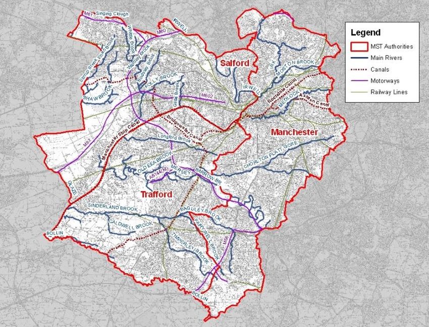
Figure 2-1 presents an overview of the MST authorities showing the Main Rivers, canals,
railway lines and motorways.
2009s0290 Final MST Level 1 SFRA Mar 2010.docx 4Figure 2-1: Overview Map
© Crown Copyright. All rights reserved. Licence number 100019568 2010
2009s0290 Final MST Level 1 SFRA Mar 2010.docx 52.2 Fluvial Flood Risk
According to the Greater Manchester sub-regional SFRA, a significant source of flood risk
across the region is from fluvial flooding. Fluvial flooding is flooding caused by high flows
in rivers or streams exceeding the capacity of the river channel and spilling onto the
floodplain, usually after a period of heavy rainfall.
Many of these rivers are large and form a focal point to the urban areas that surround
them. Their presence through surrounding urban centres places a number of properties
and people at risk on their floodplains. Flood risk on these watercourses is well
documented and researched, with the majority of them modelled as part of Environment
Agency flood mapping studies. Flood Zones produced by such studies provide the basis
of the Environment Agency Flood Map.
However, due to the nature of the urban environment, a number of smaller watercourses
have been culverted or diverted to make space for development. Some watercourses
were in-filled or disconnected as the need for water supply to mills or other industries
ceased. These watercourses are referred to as hidden or lost. The condition and
standard of protection of these watercourses are unknown but they can provide a
significant source of flood risk.
Manchester, Salford and Trafford contain over 250km of inland designated Main Rivers,
which the Environment Agency has permissive powers to maintain. This does not include
extensive additional lengths of Ordinary Watercourses or other privately owned streams or
drains. These watercourses are the responsibility of the Local Authorities.
The majority of watercourses in the SFRA study area are within the River Irwell and Upper
Mersey catchments. A list of the larger watercourses is provided in Table 2-1.
Table 2-1: Larger watercourses and their tributaries
Manchester Salford Trafford
River Irwell River Irwell
Singing Clough
Singleton Brook
Grey Irwell Grey Irwell
River Irwell River Irwell
River Irk
River Medlock
River Irk
Boggart Hole Brook
Boardman Brook
Moston Brook
River Medlock
Corn Brook
MSC MSC
Grey Irwell Corn Brook
Whittle Brook Bent Lanes Brook (Longford
Linnyshaw Brook Brook)
How Clough River Mersey
Sindsley Brook Red Brook (Sinderland
Folly Brook Brook)
Salteye Brook (Worsley
Brook)
Gilda Brook
2009s0290 Final MST Level 1 SFRA Mar 2010.docx 6Manchester Salford Trafford
Kempnough Brook
Wardley Brook
Platts Brook
River Mersey River Mersey
Chorlton Platt Gore Barrow Brook
Cringle Black Brook Old Eea Brook
Didsbury Inlet Channel Carrs Ditch
Fielden Park Brook Stromford Brook
Gatley Brook Carrington Moss Brook
Warburton Brook
Sinderland Brook Sinderland Brook
Timperley Brook Caldwell Brook
Fairywell Brook Timperley Brook
Baguley Brook Fairywell Brook
Baguley Brook
Glaze Brook
Moss Brook
Astley Brook
Ellen Brook
Shakerley Brook
Wharton Brook
Blue Box Ditch
Shaw Brook
Stirrup Brook
Sniggley Brook
Moss House Farm Brook
Moss House Brook
Whitehead Brook
White Box Ditch
River Bollin River Bollin
Old Bollin Brook
Dunham Hall Brook
The larger watercourses are discussed below. The Manchester Ship Canal is discussed
in section 2.7.
2.2.1 River Irwell
The Irwell is one of the rivers that drove the industrial revolution, evidence of which
remains today in the form of the large number of former textile mills along the river
corridor. The river and its main tributaries are strongly connected with the urban areas
through which they pass and have been largely responsible for their establishment, growth
and expansion.
The River Irwell rises from Irwell Spring on Deerplay Moor and runs south in a course
through the towns of Bacup, Rawtenstall, Ramsbottom, Bury, Radcliffe (where it is joined
by the River Roch), Farnworth (where it is joined by the River Croal), Kearsley, Salford
and Manchester. The River Irwell is not enmained between Cottenham Lane footbridge
and Woden Street footbridge; the MSC starts at Woden Street footbridge but navigation
rights may extend the length of the non main channel.
The river is known as the 'Grey Irwell' between the confluences of the Rivers Irk and
Medlock. The Grey Irwell separates the city centres of Manchester and Salford. The Grey
Irwell drains into the Manchester Ship Canal, which is the canalised lower section of the
River Irwell.
2009s0290 Final MST Level 1 SFRA Mar 2010.docx 7The lower reaches of the Irwell have flooded many times in its history; the most well
documented being the floods of 1946, 1954, 1980, and 2008.
The Environment Agency maintains the Kersal Flood Storage Reservoir and associated
raised defences, which provides a 1 in 75 year standard of protection (SoP) to
approximately 3,000 properties in the Kersal and Lower Broughton area of Salford. The
area benefitting from this scheme is classified as an Area Benefiting from Defences
(ABD).
2.2.2 River Irk
The River Irk rises near Shaw in Oldham. It flows south west passing through Royton and
Middleton before flowing southwards towards Manchester City Centre, where it joins the
River Irwell. The main tributaries of the Irk include Boggart Hole Brook and Moston Brook.
The Irk is relatively constrained to the channel until the floodplain widens between
Crumpsall and Harpurhey in Manchester. Raised defences protect Vale Park Industrial
Estate to a 1 in 50 year standard. The area benefitting from this scheme is classified as
an Area Benefiting from Defences (ABD).
The floodplain extends again as the Irk reaches the city centre, upstream of Victoria
Station.
2.2.3 River Medlock
The River Medlock rises in the hills to the east of Oldham. It flows through Oldham and
Tameside before reaching Clayton in Manchester. The lower reaches of the river join the
River Irwell in central Manchester and are extensively culverted.
The floodplain of the River Medlock is relatively natural through Clayton Vale. The
Medlock is culverted under the City of Manchester Stadium and continues to meander in
and out of culvert through the city centre. Flood Zone 2 and 3 is relatively wide through
the urban landscape in the downstream reaches.
2.2.4 Corn Brook
Corn Brook drains the urban area south of the River Medlock. The brook is largely
culverted and flows from Openshaw in a westerly direction, discharging into the
Manchester Ship Canal at Pomona Docks. There are open lengths at the upstream reach
(around 750m) and upstream of the siphon under the Bridgewater Canal (around 20m).
The culverted nature of the channel can result in significantly longer overland flow paths
for floodwaters to return to the channel than would be expected in an open channel. This
is reflected in the Flood Zones through Brunswick and Moss Side. The Flood Zones also
highlight flooding upstream of the railway line in West Gorton.
2.2.5 River Mersey
The Mersey is formed from three tributaries: the Rivers Etherow, Goyt and Tame. The
generally accepted start of the Mersey is at the confluence of the Tame and Goyt, in
central Stockport. From Stockport it flows near Didsbury, Northenden, Stretford, Urmston
and Flixton. At Carrington the Mersey flows into the Manchester Ship Canal (see section
2.7.2 for information on the MSC). The other main tributaries of the River Mersey are
Chorlton Platt Gore, Barrow Brook, Stromford Brook, Carrington Moss Brook, Old Eea
Brook and Carrs Ditch.
The Mersey meanders through Manchester and Trafford with an extensive floodplain
reaching 1km wide in places.
There are two Flood Storage Areas along the Mersey at Didsbury and Sale Ees Water
Park, which benefit downstream urban areas with up to a 1 in 50 year standard of
protection.
2009s0290 Final MST Level 1 SFRA Mar 2010.docx 82.2.6 Sinderland Brook and tributaries
Baguley Brook rises south of Wythenshaw and flows northwards. At its confluence with
Brownley Brook north of Wythenshaw it turns due east and flows towards the MSC. At the
confluence of Timperley Brook and Baguley Brook the watercourse becomes known as
Sinderland Brook. The watercourse outfalls into the Manchester Ship Canal to the south
of Partington in Trafford, where it is known as Red Brook,
The Environment Agency have recently completed a 2D modelling study for the
Sinderland Brook and tributaries that shows there is the highest risk of flooding upstream
of the Bridgewater Canal.
There has been historic flooding on the Sinderland Brook. A scheme has recently been
implemented in Altrincham where a stretch of the Sinderland Brook has been deculverted
and restored, which provides an element of flood storage.
2.2.7 Glaze Brook
Glaze Brook rises to the south east of Wigan and outfalls to the Manchester Ship Canal at
Cadishead in Salford. Flood risk arises after prolonged rainfall when water overtops
watercourse banks or following intense and heavy rainfall when local drainage capacity is
exceeded. Localised flooding is associated with the catchments of Ellen Brook and Shaw
Brook in Boothstown in Salford.
2.2.8 River Bollin
The River Bollin has a largely rural catchment and rises in the Pennines. It forms the
boundary between Cheshire East and Trafford Councils. There is low flood risk to
Manchester and Trafford from the River Bollin.
2.2.9 "Hidden" and Culverted Watercourses
There are other watercourses within the Greater Manchester area which are not captured
on Environment Agency maps. Many modified small streams, brooks and culverts are
now hidden below ground and their condition is deteriorating; they become blocked with
debris and are the cause of much localised flooding following heavy rainfall. Some of
these have been mapped by Ashworth in 1987 and are referred to as the „hidden rivers of
Manchester‟.
Due to the heavily urbanised nature of Greater Manchester, only a few of the
watercourses are in their natural form. Many of the main river channels have been
straightened and canalised to accelerate the flow of water and have been culverted over
significant lengths. Many of the channels and culverts have a limited hydraulic capacity
and are prone to blockages which can lead to flooding. The blockages are caused by silt
deposition from the rural upstream sections of the catchments, vegetation falling into the
river or through fly tipping.
The Greater Manchester Sub-Regional SFRA identified and mapped culverted
watercourses using National Flood and Coastal Defence Database (NFCDD) and hidden
watercourses with aid from Manchester University. An overview of the magnitude of the
culverted channels identified in this report is provided in Table 2.2.
The majority of hidden watercourses are located in the Manchester district. The
Environment Agency is currently preparing the South Manchester Flood Risk Management
Strategy which is likely to investigate this risk further.
2009s0290 Final MST Level 1 SFRA Mar 2010.docx 93
Table 2-2: Culverted Channels
Authority Length of Culverted Channel (km) as identified in the Greater
Manchester Sub-Regional SFRA
Manchester 19.64
Salford 10.65
Trafford 13.09
Further information on culverted channels in Salford is available through the Highway
Strategy Group.
2.3 Flooding from Land
The Environment Agency has recently produced a national map of Areas Susceptible to
Surface Water Flooding (ASSWF), which identifies areas susceptible to surface water
flooding during an extreme rainfall event (1 in 200 year). This is valuable as it provides an
indication of the likelihood of surface water flooding, separated into areas at less,
intermediate or high susceptibility.
Urban drainage modelling is a complex field, varying from simple topographic analysis, to
routing of water over an elevation model (which is how the national ASSWF map has been
produced), to network models of the sewer system linked to overland routing, to fully
integrated river, sewer and overland models. SFRAs require a strategic assessment of
the likelihood of surface water flooding for which overland routing is suitable and
appropriate.
As part of the Level 2 SFRA, refined surface water maps for Manchester, Salford and
Trafford were produced using overland routing modelling. These maps used more detailed
topographic data and incorporated the presence of buildings and roads into the modelling
and are hence considered to supersede the ASSWF maps. As per the national map this
provides an indication of the likelihood of surface water flooding, separated into areas at
less, intermediate or high susceptibility.
The Level 2 SFRA surface water flood map and flood risk assessment indicates that the
following wards are at highest risk of surface water flooding:
Manchester
● City Centre
● Levenshulme
● Didsbury East
● Northenden
● Charlestown
Salford
● Pendlebury
● Swinton North
● Weaste and Seedley
● Eccles
● Little Hulton
Trafford, risk is lowest here with the following wards at the most risk:
● Bowdon
● Broadheath
● Gorse Hill
3
AGMA (2008) Greater Manchester Sub-Regional SFRA – lengths calculated using NFCDD
2009s0290 Final MST Level 1 SFRA Mar 2010.docx 102.4 Flooding from Sewers
The information available from United Utilities (UU) included DG5 records, location of
drainage areas and sewers records. United Utilities sewer flood risk data was not
available in the timescales for this project. The Local Authorities should continue to work in
partnership with United Utilities over the availability and use of sewer flood risk data.
United Utilities flood risk data should be used in further work following on from this SFRA,
including Surface Water Management Plan work.
Whilst the DG5 register can give an idea of those areas with limited drainage capacity, it
must be acknowledged that it is a register of properties that have already been flooded
due to exceedance or the blockage or failure of sewer systems, not properties at risk of
flooding. In addition to this, sewer flooding problems may have been investigated and
resolved since the register was compiled. For these reasons the DG5 register alone has
limited usefulness in predicting future flooding locations.
Surface water and sewer flooding is often interconnected. For example, high water levels
in receiving watercourses and the Manchester Ship Canal could prevent the free
discharge of surface water or combined sewer overflows through the sewer network. This
could cause the sewer network to back up and surcharge, causing flooding.
Information from the MST authorities and the AGMA Sub-Regional SFRA indicates that
sewer flooding problems are present throughout the large urban areas.
In Manchester, sewer and drainage problems have been identified during rainfall events,
with issues in Northenden, Didsbury, Fallowfield and in the city centre.
Sewer flooding is known to have occurred in Salford where up to 1,000 properties are at
risk of localised flooding from surface water, sewers and smaller watercourses. Flood risk
data has been provided by Salford City Council which identifies sewer flooding hotspots in
Walkden, Worsley, Peel Green, Swinton and Boothstown.
In Trafford sewer flooding is known to be a problem in Flixton, Altrincham and Sale.
2.5 Flooding from Groundwater
Groundwater flooding is caused by the natural emergence at the ground surface, of water
originating from underlying permeable sediments or rocks (aquifers). The groundwater
may emerge as one or more point discharges (springs) or as diffuse discharge/seepage
over an extended area. Groundwater flooding tends to be more persistent than other
sources of flooding, typically lasting for weeks or months rather than for hours or days.
Groundwater flooding does not generally pose a significant risk to life due to the slow rate
at which the water level rises; however, it can cause significant damage to property,
especially in urban areas.
Refer to Map 2.1 for more information on the pattern of potential groundwater flooding.
2.5.1 Historical Records of Groundwater Flooding
According to Greater Manchester sub-regional SFRA there are no known reports of
groundwater flooding in the Manchester, Trafford and Salford authorities. However, a
number of areas within Trafford appear to suffer from a high water table or standing water
(Map 2.1):
● Stamford Brook Development.
● South of Edge Lane, Stretford.
● Areas of Timperley in the vicinity of Heyes Lane and Fairywell Brook.
In parts of Salford there are problems with waterlogged ground and cellars in Winton (off
the B5211 Worsley Road near Worsley Brook) that are known to flood. Waterlogging of
the ground may be due to the presence of slowly permeable soil rather than a shallow
water table. However, the flooding of basements close to a watercourse is likely to
2009s0290 Final MST Level 1 SFRA Mar 2010.docx 11represent alluvial groundwater flooding. Alluvial deposits are those close to a watercourse
that have been laid down by the river over time.
Past studies have identified 15 sites in England where groundwater levels were known to
4
be rising . One of these was Trafford Park in Manchester, where groundwater levels rose
by about 15m between 1970 and 1986. This rise was due to a reduction in abstraction
from the Permo-Triassic sandstone aquifer. The Environment Agency (2007) identified
the area around Trafford Park and Stretford as being potentially at risk of groundwater
rebound.
Reduced abstraction has also led to groundwater rebound in central Manchester, although
5
levels have now stabilised .
Minewater rebound
The AGMA Sub-Regional SFRA highlighted minewater rebound as a potential issue for all
three districts. The Coal Authority is responsible for monitoring rising groundwater levels
resulting from the cessation of mine dewatering. The Coal Authority considers minewater
levels in Manchester, Salford and Trafford to have recovered or almost recovered. Some
areas are likely to experience a slight rebound, but the effects of this will be minimal.
Mechanisms
Table 2-3 lists the various mechanisms of groundwater flooding and assesses the
likelihood of occurrence. The mechanisms most likely to be significant in the area are
alluvial groundwater flooding and groundwater rebound. The one reported case of
groundwater flooding (flooding of basements in Winton, Salford) appears to be due to
alluvial groundwater flooding.
Table 2-3: Groundwater Flood Risk Assessment for Manchester, Trafford and Salford
Mechanism Likelihood Comments
1. Prolonged heavy Low This mechanism is mainly associated with
rainfall in an area chalk aquifers but none are present in the
with a shallow water Manchester/Trafford/ Salford area. The
table. aquifers in the study area generally have high
storage potential and so have relatively small
fluctuations in groundwater level. However,
there is still the potential for localised
groundwater flooding (e.g. of basements) in
areas with a very shallow water table.
See Map 2.1.
2. Alluvial Moderate The risk is greatest where permeable alluvial
groundwater flooding sediments are connected to a major river,
due to high river e.g. the Mersey. The one reported instance
levels. of basement flooding occurs close to a
watercourse (Worsley Brook, Salford).
See Map 2.1
3. Groundwater Low to moderate This is most significant in the Trafford Park -
rebound due to Stretford area.
decreased
abstraction. See Map 2.1
4. Minewater rebound Low Water levels are mostly recovered.
4
Brassington, F. C., 1990. Rising groundwater levels in the United Kingdom. Proceedings of the Institution of
Civil Engineers, vol. 88, part 1, p.1037-1057.
5
Jacobs, 2004. Strategy for Flood and Coastal Erosion Risk Management: Groundwater Flooding Scoping
Study (LDS 23). Final Report produced for Defra, 2 Volumes, May 2004.
2009s0290 Final MST Level 1 SFRA Mar 2010.docx 12Mechanism Likelihood Comments
due to cessation of
mine dewatering.
5. Ground Low The area has been undermined, so there is
subsidence. the potential for some subsidence - for
example, due to the collapse of supporting
pillars. However, it is likely that most
subsidence has already occurred.
6. Leaky drains, Low Possibly of local significance.
sewers and water
supply mains.
7. Artificial Low Possibly of local significance. This
obstructions. mechanism is only likely to be important
where there is a very thin shallow aquifer and
very dense development.
8. Faulty borehole Low Restricted to areas where boreholes
constructions. penetrate confined bedrock aquifers.
9. Seepage into Low Possibly of local significance.
tunnels and unlined
trenches.
10. Infiltration Low Possibly of local significance. This
drainage raising the mechanism is only likely to be important in
water table. areas of permeable ground with a shallow
water table.
The part of Trafford identified by Scott Wilson
(2008a, b) as being suitable for infiltration-
based Sustainable Drainage Systems
includes areas where the water table is likely
to be near the surface (as suggested by the
GEM and by information about Timperley
supplied by Trafford Council).
2.6 Flooding from Reservoirs
The Environment Agency did not provide a copy of the Reservoir Register, which identifies
those reservoirs under the Reservoirs Act, due to “implications for national security”.
However, discussions with councils and a review of OS mapping shows there a number of
reservoirs within or adjacent to the Manchester City, Salford City and Trafford Council
areas. Table 2-4 identifies the reservoirs and the main urban area at risk immediately
downstream of them. This is not an exhaustive list of upstream reservoirs but is included
to highlight the key reservoirs.
Table 2-4: Key Reservoirs
Reservoir Name Local Authority Downstream Urban Area
Blackleach Salford Walkden, Linnyshaw, Worsley
Whittle Brook Salford Walkden
Old Warke Dam Salford Alder Forest
Dunham Park (covered) Trafford Parklands, Hale
Sale Ees (Flood Storage Sale
Reservoir) Trafford
Heaton Park Manchester Whitefield, Crumpsall,
2009s0290 Final MST Level 1 SFRA Mar 2010.docx 13Reservoir Name Local Authority Downstream Urban Area
Harpurhey
Heaton Park Boating Lake Manchester Crumpsall
Didsbury (Flood Storage Manchester Northenden, Didsbury
Reservoir)
Gorton Lower and Upper Manchester Gorton, Rusholme, Fallowfield,
(Debdale) Whalley Range
Gorton, Rusholme,
Levenshulme, Fallowfield,
Audenshaw Tameside Whalley Range
Alkrington Hall Rochdale Higher Blackley, Alkrington
Clarkes Hill (covered) Bury, Manchester Whitefield
2.7 Flooding from Canals
The following canals lie within Manchester, Salford and Trafford:
● The Rochdale Canal, passing through the north of the Manchester City Council
area.
● The Ashton Canal, passing through the east of the Manchester City Council area.
● The Bridgewater Canal, passing through each Council area.
● The Manchester Ship Canal, which forms the boundary between Salford City and
Trafford Councils.
● The recently reopened length of Manchester, Bolton and Bury Canal in Salford
City Council area.
There are two types of canal:
1. Broad Canal. The Bridgewater, Ashton, Manchester, Bury and Bolton and
Rochdale Canals are broad canals that were initially built to serve the growing
industrial centres of the North West during the Industrial Revolution. These are
fairly shallow canals that have raised embankments in places and mainly used
today for tourism, carrying narrow boats and other small boats. The Ashton,
Manchester, Bury and Bolton and Rochdale Canals are managed by British
Waterways. The Bridgewater Canal is owned and operated by the Manchester
6
Ship Canal Company in conjunction with the Bridgewater Canal Trust .
2. Ship Canal. The Manchester Ship Canal was built by canalising sections of the
lower River Irwell and River Mersey in the late nineteenth century to allow large
ships to dock in Manchester city centre. The MSC is managed by the Manchester
Ship Canal Company and water levels in the canal are carefully monitored and
controlled by a system of sluices. Although named as a canal, the MSC is a
canalised watercourse and hence its flooding mechanisms have more in common
with a watercourse than a typical canal.
Both British Waterways and the Manchester Ship Canal Company are key stakeholders in
the management of canals and have been consulted as part of the SFRA process.
The interaction between these canals and the main rivers, particularly in Manchester City
Centre, are integral to the understanding of flood risk. Figure 2-2 presents a schematic
showing this interaction.
6
www.bridgewatercanal.co.uk [Access date March 2010]
2009s0290 Final MST Level 1 SFRA Mar 2010.docx 142.7.1 Risks from Broad Canals
These canals do not pose a direct flood risk as they are controlled water bodies with
regulated flows. However, there are residual risks associated with lower probability events
such as breaching of embankments. The residual risk associated with canals is unknown
as it depends on a number of factors including: the source of water into the canal,
materials used within the canal embankments and the condition of those embankments.
The risk is limited due to continued maintenance by British Waterways (Ashton,
Manchester, Bury and Bolton and Rochdale Canals) and the Manchester Ship Canal
Company (Bridgewater Canal) and the controlled volume of water within an impounded
length. If an event occurs the consequences can be quite high, especially if people or
properties are situated directly below the breached length.
The potential residual risks from each of the Broad Canals are discussed below.
Risks on the Rochdale Canal
The main flood hazards on the Rochdale Canal are perceived to arise from overtopping
and/or breaching. Specific issues include:
● a potentially high inflow to the canal with flow towards Manchester during flood
conditions which exceeds the canal capacity at Manchester,
● overtopping and possible failure of the raised embankment at Miles Platting.
Risks on the Ashton Canal
The main flood hazards on the Ashton Canal are perceived to arise from overtopping
and/or breaching. Specific issues include:
● a potentially high inflow to the canal with flow towards Manchester during flood
conditions which exceeds the canal capacity at Manchester,
● possible blockage of the bywash at Ancoats in flood conditions and a consequent
overtopping of the canal banks.
Risks on the Bridgewater Canal
The main flood risks on the Bridgewater Canal are perceived to arise from overtopping
and/or breaching. Specific issues include:
● a potentially high inflow to the Bridgewater Canal at Worsley from overtopping of
Old Warke Dam and M60 surface water discharges during flood conditions.
● a potentially high inflow to the Bridgewater Canal from the Rochdale Canal during
flood conditions,
● a potentially high inflow to the Bridgewater Canal from the MSC around Pomona
Island during flood conditions,
● a potentially high inflow to the Bridgewater Canal from the River Medlock or Corn
Brook during flood conditions,
● a potentially high inflow in the Bridgewater Canal towards Manchester caused by
a net inflow over the 60km pound to the west of Manchester in peak flood
conditions,
● westerly winds during flood conditions which would increase the canal water levels
at Manchester (similar to the 1987 event),
● a total combined inflow which exceeds the canal capacity leading to a breach of a
raised section into development areas with lower land levels (similar to the
Dunham Massey failure, 1971).
2009s0290 Final MST Level 1 SFRA Mar 2010.docx 15Risks on the Manchester, Bury and Bolton Canal
The Manchester, Bury and Bolton canal is derelict and infilled throughout much of Salford.
There are plans by British Waterways to restore the canal by 2020 and the path of the
canal is protected from development. However the exact location, capacity and structures
to restore the canal are unknown. Hence flood risk from this canal has not been
considered in the SFRA, but will need to be in the future if and when canal restoration is
taken forward.
2.7.2 Risks on the Manchester Ship Canal
The Manchester Ship Canal (MSC) in the study area is fed by the rivers Grey Irwell,
Medlock, Mersey and Bollin and the Gilda Brook, Worsley (Salteye) Brook, Longford (Bent
Lanes) Brook, Platts Brook, Glaze Brook, Sinderland Brook, Warburton Park Brook and
Warburton Brook. The Manchester Ship Canal drains the catchments of the River Irwell
and Mersey and hence in a flood event could receive significant inflows from these
systems, potentially causing overtopping.
However, the canal has a large capacity in Greater Manchester. Water levels in the canal
are carefully monitored and controlled by a system of sluices. At Mode Wheel Locks the
canal has a capacity of approximately 600m³/s. If water levels rise at Manchester city
centre the sluices are opened to allow water to pass down the system.
There are no raised flood defences along the MSC and therefore no records of breaching
of raised sections. The tow path at Pomona Docks has been known to flood. Part of the
Manchester surface water drainage system drains into the canal and inflows may be
significant in storm conditions.
2009s0290 Final MST Level 1 SFRA Mar 2010.docx 16Figure 2-2: Schematic Showing Interaction between Watercourses and Canals
Key
? Canal inflows in flood conditions (magnitude unknown)
Rivers
Canals
? ?
River
River Medlock
Irwell
Rochdale
River Irk Canal Ashton Canal
Grey Irwell Spill
Medlock Cloughs
Spill
Manchester Ship Canal Bridgewater Canal
Giants Basin
Corn Brook
Mode Wheel Locks
600 m 3/s capacity
approx
River Mersey
Bridgewater Canal
? ?
2009s0290 Final MST Level 1 SFRA Mar 2010.docx 172.8 Historical Flooding
Records of past flooding are useful for looking at the sources, seasonality, frequency and
intensity of flooding. Table 2-5 provides an overview of significant flood events in
Manchester, Salford and Trafford. Historical records are often anecdotal and incomplete
and it can be difficult to determine accurately the frequency and consequences of events,
but they are useful for providing background information. More recent gauged records
and registers of flooded properties are valuable for estimating flood frequency and severity
at different locations.
Also, flood risk can change over time because of natural variations in climate, changes in
land use and the changes in flood risk management activity. Over the last few hundred
years, developments have been increasingly built on the floodplain and there is some
evidence that farming practices that promote rapid run-off of rainwater into rivers have
become widespread. Due to these changes, flood risk might be higher today than it was
in the past, although any flood risk management work that is undertaken helps to reduce
this.
The Environment Agency also maintains a National Historic Flood Map which records
known flood extents (referred to as Flood Event Outlines). Locations shown as being
affected in the past are listed in Table 2-5.
Table 2-5: Historical Flood Events
Date Source Description Data source
2008 MSC Overtopping of tow path SFRA Steering Group
2008 River Irwell Littleton Road Flood Basin Salford City Council
operated. Flooding of low
lying land - no reports of
properties flooded
2007 Ashton Canal Flooding reported at EA Flood Event Outline
Ancoats
2006 Surface water Roads and 20 houses in Irwell CFMP
Heywood flooded
2004 MSC Overtopping of MSC flooded Salford City Council
16 properties at Barton
Upon Irwell and roads in
Peel Green
2004 Worsley Flooding of roads and EA Flood Event Outline
Brook properties in Alder Forest Salford City Council
2004 Sewers Altrincham, Flixton, Sale, Trafford Council
Hale. Sewer flooding
following intense rainfall.
Flooded gardens, highways
and properties
2004 Chorlton Flooded Halls of Residence, AGMA Sub-regional SFRA
Brook Manchester University,
Fallowfield
2002 Medlock Analysis of London Road River Medlock SFRM, 2009
Gauging Station readings
indicate the event return
period to be approximately
80 years
2002 Irwell 11 properties flooded in Irwell CFMP
Irwell Vale
2009s0290 Final MST Level 1 SFRA Mar 2010.docx 18You can also read