CONSENTABILITY OF SHORT- TERM ADAPTATION RESPONSES - HAWKE'S BAY REGIONAL COUNCIL Stage 4 Clifton to Tangoio Coastal Hazard Strategy 2120 - HB Coast
←
→
Page content transcription
If your browser does not render page correctly, please read the page content below

HAWKE’S BAY REGIONAL COUNCIL

CONSENTABILITY OF SHORT-
TERM ADAPTATION
RESPONSES

Stage 4 Clifton to Tangoio Coastal
Hazard Strategy 2120

July 2020
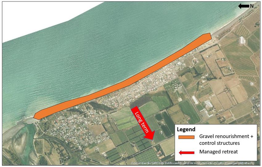
TABLE OF CONTENTS

1.   Introduction ___________________________________________________________ 1

     1.1         Purpose of the Report                                                1
     1.2         Structure of the Report                                              2
2.   The Clifton to Tangoio Coastal Hazard Strategy 2120 __________________________ 2

     2.1         Overview                                                             2
     2.2         Strategy Development Process                                         3
     2.3         Overview Stage 3 Assessment Panel Recommendations                    5
3.   Overview of Priority Units _______________________________________________ 6

     3.1         Whirinaki                                                            6
     3.2         Bay View                                                            12
     3.3         Westshore                                                           18
     3.4         Pandora                                                             26
     3.5         Haumoana                                                            34
     3.6         Te Awanga                                                           42
     3.7         Clifton                                                             47
4.   Overview of Regulatory Framework ______________________________________ 52

     4.1         New Zealand Coastal Policy Statement                                52
     4.2         Hawke’s Bay Regional Resource Management Plan                       53
     4.3         Hawke’s Bay Regional Coastal Environment Plan                       53
     4.4         City of Napier District Plan                                        54
     4.5         Hastings District Plan                                              54
5.   Key Consenting Issues and Consenting Risks _______________________________ 55

     5.1         Overview of Consenting Requirements                                 55
     5.2         New Zealand Coastal Policy Statement                                58
     5.3         Marine and Coastal Area (Takutai moana) Act 2011                    59
     5.4         Reserves Act 1977                                                   61
     5.5         Heritage New Zealand Pouhere Taonga Act 2014                        62
     5.6         Westshore, Bay View and Whirinaki Consenting Challenges             62
     5.7         Pandora Consenting Challenges                                       64
     5.8         Haumoana and Te Awanga Consenting Challenges                        67
     5.9         Clifton Consenting Challenges                                       68
     5.10        Community Engagement                                                69
6.   Case Studies ________________________________________________________ 70

     6.1         Hawke’s Bay Region – Whakarire Avenue Breakwater                    70
     6.2         Hawke’s Bay Region – Clifton Revetment                              72
     6.3         Gisborne Region – Erosion Protection Works                          74
7.   Conclusions _________________________________________________________ 76

     Stage 4 Consentability of Short-Term Adaptation Responses: Clifton to Tangoio
     Coastal Hazard Strategy 2120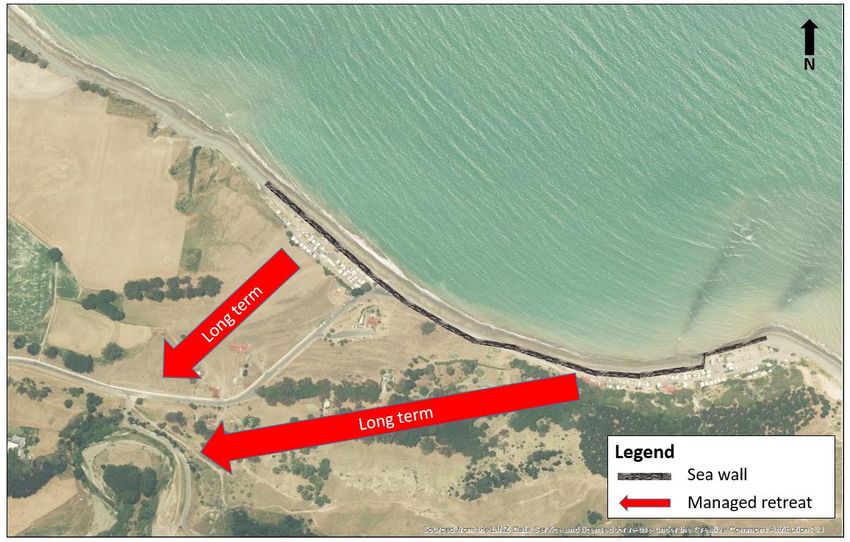
LIST OF FIGURES

Figure 1:    Clifton to Tangoio Coastal Hazard Strategy – Process of Development               3

Figure 2:    Zoning of the Whirinaki Priority Unit and surrounds under the Hastings District
             Plan.                                                                             8

Figure 3:    Zoning of the Whirinaki Priority Unit and surrounds under the Hawke’s Bay
             Regional Coastal Environment Plan.                                                9

Figure 4:    Zoning of the Bay View Priority Unit and surrounds under the Napier District
             Plan.                                                                           14

Figure 5:    Zoning of the Bay View Priority Unit and surrounds under the Hawke’s Bay
             Regional Coastal Environment Plan.                                              15

Figure 6:    Design gravel barrier used to inform modelling and engineering design (Beya
             and Asmat, 2019).                                                               19

Figure 7:    Approximate areas of the Westshore priority unit were an extension to the
             existing gravel barriers is required (Beya and Asmat, 2019).                    19

Figure 8:    Zoning of the Westshore Priority Unit and surrounds under the Napier District
             Plan.                                                                          22

Figure 9:    Zoning of the Westshore Priority Unit and surrounds under the Hawke’s Bay
             Regional Coastal Environment Plan.                                             23

Figure 10: Layout design for the proposed flood defences in the Pandora Priority Unit
             (Beya and Asmat, 2020).                                                        27

Figure 11:   Typical stop bank cross section (Beya and Asmat 2020).                         27

Figure 12: Sheet pile ground levels crest height (Beya and Asmat, 2020).                    28

Figure 13: Typical design cross section of cantilevered reinforced concrete wall and
             revetment (Beya and Asmat, 2020).                                              28

Figure 14: Approximate location and length of storm surge barrier (Beya and Asmat,
             2020).                                                                         29

Figure 15: Zoning of the Pandora Unit and surrounds under the City of Napier District
             Plan.                                                                          30

Figure 16: Zoning of the Pandora Unit and surrounds under the Hawke’s Bay Regional
             Coastal Environment Plan.                                                       31

Stage 4 Consentability of Short-Term Adaptation Responses: Clifton to Tangoio
Coastal Hazard Strategy 2120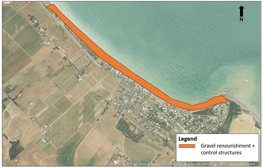
Figure 17: Overview of the proposed short-term adaptation response for Haumoana and
            Te Awanga (Beya and Asmat, 2019).                                              35

Figure 18: Zoning of the Haumoana, Te Awanga and surrounds under the Hastings
            District Plan.                                                                 36

Figure 19: Zoning of Haumoana and surrounds under the Hawke’s Bay Regional Coastal
            Environment Plan.                                                              38

Figure 20: Zoning of Te Awanga and surrounds under the Hastings District Plan.             43

Figure 21: Zoning of Te Awanga and surrounds under the Hawke’s Bay Regional Coastal
            Environment Plan.                                                              44

Figure 22: Proposed extension to the existing revetment at Clifton (Beya and Asmat,
            2019).                                                                         48

Figure 23: Zoning of the Clifton Unit and surrounds under the Hastings District Plan       49

Figure 24: Zoning of the Clifton Unit and surrounds under the Hawke’s Bay Regional
            Coastal Environment Plan.                                                      50

Figure 25: Potential structure of resource consent application for Stage 4 implementation
            phase of the Strategy.                               Error! Bookmark not defined.

LIST OF TABLES

Table 1:    Overview of the Assessment Panel adaptation pathway recommendations as
            part of the Strategy.                                                           5

Table 2:    Summary of likely consent requirements at Whirinaki. Blue shading identifies
            consents required from the HBRC.                                               11

Table 3:    Summary of likely consent requirements at Bay View. Blue shading identifies
            consents required from the HBRC.                                               17

Table 4:    Summary of likely consent requirements at Westshore. Blue shading identifies
            consents required from the HBRC.                                               25

Table 5:    Summary of likely consent requirements at Pandora. Blue shading identifies
            consents required from the HBRC, while green shading identifies consents
            required from NCC.                                                             32

Table 6:    Summary of likely consent requirements at Haumoana. Blue shading identifies
            consents required from the HBRC, while green shading identifies consents
            required from HDC.                                                             40

Stage 4 Consentability of Short-Term Adaptation Responses: Clifton to Tangoio
Coastal Hazard Strategy 2120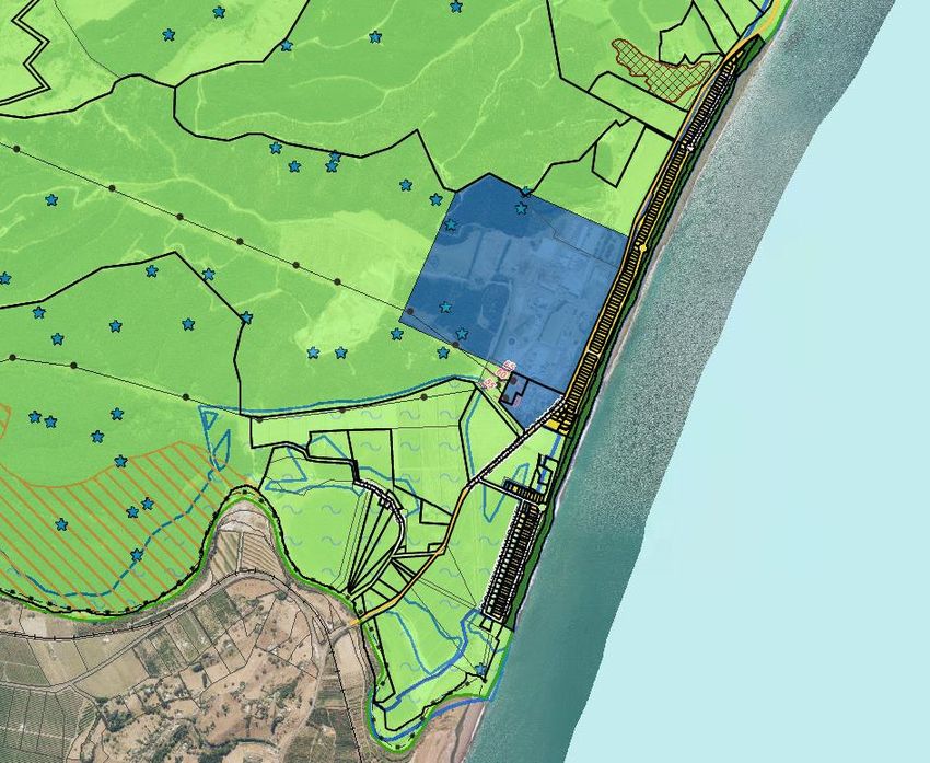
Table 7:    Summary of likely consent requirements at Te Awanga. Blue shading identifies
            consents required from the HBRC, while green shading identifies consents
            required from HDC.                                                           45

Table 8:    Summary of likely consent requirements at Clifton. Blue shading identifies
            consents required from the HBRC, while green shading identifies consents
            required from HDC.                                                           51

Table 9:    Summary of the types of resource consents required for each Priority Unit.   55

Table 10:   Summary of associated approvals required under other statutes for each
            Priority Unit.                                                               58

Stage 4 Consentability of Short-Term Adaptation Responses: Clifton to Tangoio
Coastal Hazard Strategy 2120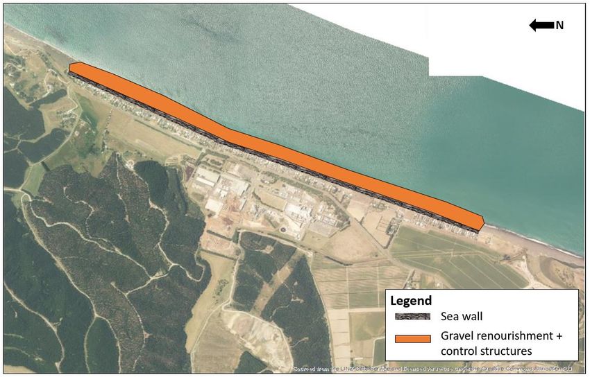
REPORT INFORMATION

 Report Status        Final

 Our Reference        MDL001088

 Author               Kirsty O’Sullivan

 Review By            Stephen Daysh

© Mitchell Daysh Limited (2020).

This document and its contents are the property of Mitchell Daysh Limited.
Any unauthorised employment or reproduction, in full or in part, is forbidden.

Stage 4 Consentability of Short-Term Adaptation Responses: Clifton to Tangoio
Coastal Hazard Strategy 2120
1.    INTRODUCTION
      Clifton to Tangoio Coastal Hazard Strategy 2120 (“the Strategy”) is entering into Stage 4
      of a four-stage development process. Stage 4 will culminate in the identification of a clear
      implementation plan which will identify the actions required to implement the preferred
      adaptation pathways identified as part of Stage 3 of the Strategy development process.

      This report discusses the consentability of the short-term adaptation responses identified
      as part of Stage 3 of the Strategy development process. The report forms part of the
      background investigations being undertaken by the Technical Advisory Group (“TAG”) as
      part of wider programme of works associated with Stage 4 of the Strategy.

      The report focuses on the short-term adaptation responses (i.e. those within a 0 to 20 year
      horizon) as these are the most likely to be implemented within the planning horizon of the
      relevant regional and district planning (which typically have a 10 year planning horizon).
      The regulatory environment will change beyond this timeframe, therefore evaluating
      medium to long term adaptation responses (from 20 to 50 year and 50 to 100 year
      horizons) as part of this report has limited utility.

1.1   PURPOSE OF THE REPORT

      The purpose of this report is to:

           Provide an overview of the Strategy and the adaptation pathways identified for each
           priority unit;

           Summarise the engineering concept designs developed in response to the identified
           short-term pathway for each priority unit;

           Identify the local planning context and the key environmental values ascribed to each
           priority unit;

           Provide a high-level overview of the planning framework and the key provisions that
           are likely to be determinative to the resource consent process; and,

           Identify the high-level resource consent requirements, the key consenting challenges
           based on the environmental values and the planning framework and identify
           methodologies for mitigating those challenges.

      A separate but associated Policy and Regulatory Review report 1 identifies the key policy
      and regulatory issues that may hinder the implementation of the Hawke’s Bay Coastal
      Hazard Strategy and identifies potential solutions for addressing those issues. This report
      is primarily focused on consentability under the Resource Management Act 1991 (“RMA”)

      1
          Mitchell Daysh Limited, 2020. Hawke’s Bay Regional Council Stage 4 Regulatory Review: Clifton to Tangoio
          Coastal Hazard Strategy 2120.

      Stage 4 Consentability of Short-Term Adaptation Responses: Clifton to Tangoio
      Coastal Hazard Strategy 2120                                                                         1
and identifies other statutes or matters to be considered that are often raised as part of the
      RMA consenting process.

1.2   STRUCTURE OF THE REPORT

      The report is structured as follows:

      Section 1:          Sets out the purpose of the report.

      Section 2:           Summarises the context of the Clifton to Tangoio Coastal Hazard
                           Strategy 2120.

      Section 3:           Provides an overview of the priority units including a description of the
                           adaptation response, the engineering concept design, the District and
                           Regional Coastal Plan context and the environmental values ascribed
                           to the unit.

      Section 4:          Provides a high-level overview of the regulatory framework under
                          which resource consents will be evaluated. For the purposes of this
                          assessment, emphasis has been placed on those key provisions
                          considered to be determinative to the resource consent outcome.

      Section 5:          Identifies the key consenting issues for each unit, or units with similar
                          consenting or environmental settings, and potential methodologies for
                          managing those risks.

      Section 6:          Investigates three case studies relating to the implementation of
                          coastal protection structures, two within the region and one from
                          outside the region.

      Section 7:          Concluding statements

2.    THE CLIFTON TO TANGOIO COASTAL HAZARD STRATEGY
      2120

2.1   OVERVIEW

      The Strategy represents a co-ordinated approach to identifying and responding to coastal
      hazards and the influence of sea level rise over the next 100 years. It provides a platform
      for long-term planning and decision making.

      The Strategy has been developed through a Joint Committee formed by representatives
      from the Hawke’s Bay Regional Council (“HBRC”), the Napier City Council (“NCC”), and
      the Hastings District Council (“HDC”) alongside representatives of the Maungaharuru-
      Tangitū Trust, Mana Ahuriri Trust and Heretaunga Tamatea Settlement Trust.

      Stage 4 Consentability of Short-Term Adaptation Responses – Clifton to Tangoio -
      Coastal Hazard Strategy 2120                                                           2
The Strategy:

            Covers the coastal area between Clifton to Tangoio;

            Seeks to develop a planned response to coastal hazards out to the year 2120:

            Assesses and responds to the following coastal hazards:

            o     Coastal erosion (storm cut, trends, effects of sea level rise)

            o     Coastal inundation (storm surge, set-up, run-up, overtopping and sea level rise)

            Incorporates climate change as an overriding influence.2

      The vision of the Strategy is:

            That coastal communities, businesses and critical infrastructure from
            Tangoio to Clifton are resilient to the effects of coastal hazards.

2.2   STRATEGY DEVELOPMENT PROCESS

      The Strategy was initiated in 2014 with the establishment of a Technical Advisory Group
      (“TAG”) formed by senior Council staff and advisors, and the Clifton to Tangoio Coastal
      Hazards Strategy Joint Committee (“Joint Committee”). The Strategy is being developed
      in four key stages, followed by an ongoing monitoring and review process (Figure 1).

                                                                            Stage 4:
           Stage 1:             Stage 2:             Stage 3:                                   Strategy
                                                                        Implementatio
          Define the         Framework for           Develop                                   Monitoring
                                                                         n Planning &
           Problem              Decisions           Responses                                  and Review
                                                                           Response

      Figure 1: Clifton to Tangoio Coastal Hazard Strategy – Process of Development

      Stage 1 commenced in late 2014. Fundamental to Stage 1 was the identification of the
      extent of coastal erosion and coastal inundation hazards out to 2120, and the risks these
      present. This technical study was undertaken by Tonkin & Taylor with oversight from TAG
      and the Joint Committee. This work resulted in two reports being produced: Coastal
      Hazards Assessment3 and Coastal Risk Assessment4. The coastal hazard assessment work
      was independently peer reviewed by Professor Paul Kench of Auckland University.

      2
          Note the Strategy did not include consideration of tsunami risks or ground water table rises.
      3
          Tonkin & Taylor, 2016. Clifton to Tangoio Coastal Hazards Strategy 2120 - Coastal Hazard Assessment.
      4
          Tonkin & Taylor, 2016. Hawke’s Bay Coastal Strategy - Coastal Risk Assessment.

      Stage 4 Consentability of Short-Term Adaptation Responses – Clifton to Tangoio -
      Coastal Hazard Strategy 2120                                                                          3
A mapping tool was also developed to show the newly mapped hazard extents. This
information is provided through the Hawke’s Bay Hazard Information Portal at:
http://www.hbemergency.govt.nz/hazards/portal.

Stage 2 comprised development of a bespoke decision-making framework for the 100-
year Strategy by Mitchell Daysh Limited5, based on a community decision-making model
and utilising a range of decision making tools including Multi-Criteria Decision Analysis
process (“MCDA”), Dynamic Adaptive Planning Pathways (“DAPP”) and Real Options
Analysis (“ROA”). During this stage, a funding model think-piece report was prepared by
Maven Consulting6. The preliminary funding model identified options for how planned
responses to coastal hazards risks identified in the Strategy might be paid for. The report
covers public / private benefits, the sharing of costs between Councils, and mechanisms
for securing funds, including the proposed establishment of a Coastal Contributory Fund.
Marven Consulting also prepared social impact assessments for each of the Priority Units. 7
Stage 2 was completed at the end of 2016.

Stage 3 saw the implementation of the decision-making framework that was developed in
Stage 2 to arrive at recommended responses to coastal hazards risks over the 100-year
strategy period. The process was undertaken by two Community Assessment Panels, and
their recommendations were presented to the Joint Committee in February 2018. The
recommendations of the Community Assessment Panels were adopted by the Joint
Committee on 20 February 2018 and were subsequently endorsed and adopted by the
three member Councils in principle in order to progress to Stage 4.8

Stage 4 involves the development of an Implementation Plan for the coastal hazard
responses recommended in Stage 3. Stage 4 will include the sequencing of works to be
implemented in the short-term, and the identification of any supporting funding and policy
actions, including potential regional and district plan changes. Stage 4 will also see the
development of triggers (decision points) to determine when to transfer to the next (or
different) coastal hazard response option for each priority unit of the Strategy area. The
completion of Stage 4 should culminate in the partner Councils deciding whether to
endorse and adopt the Strategy itself

5
    Mitchell Daysh, 2017. Clifton to Tangoio Coastal Hazards Strategy 2120 – Stage Two Report: Decision Making
    Framework.
6
    Maven & Environmental Management Services Limited, 2016. Stage Two – Clifton to Tangoio Coastal
    Hazards Strategy 2120: Hazards Response Funding Model.
7
    Marven Consulting, 2017. Coastal Hazards and Social Impact Assessment and Valuation for Ahuriri/Pandora,
    Westshore, Bay View and Whirinaki and a later 2017 assessment titled Cape Coast Area Coastal Hazards
    Social Impact Assessment and Valuation, prepared by Marven Consulting.
8
    Hawke’s Bay Regional Council 28 March 2018, Napier City Council 9 April 2018 and Hastings District Council
    22 March and 28 June 2018.

Stage 4 Consentability of Short-Term Adaptation Responses – Clifton to Tangoio -
Coastal Hazard Strategy 2120                                                                         4
2.3 OVERVIEW STAGE 3 ASSESSMENT PANEL RECOMMENDATIONS
Stage 3 of the Strategy culminated in the two Community Assessment Panels making
recommendations to the Joint Committee regarding their preferred adaption pathways for
each of the Strategy’s priority units. The adaptation pathways identified for each of the
nine priority units within the Strategy area are shown in Table 1 below.
Table 1: Overview of the Assessment Panel adaptation pathway recommendations
as part of the Strategy.
Short-term Medium Term Long Term
Unit
(0-20 years) (20-50 years) (50-100 years)
Northern Panel
Ahuriri Status quo → Sea wall → Sea wall
Inundation Inundation Inundation
Pandora → →
Protection Protection Protection
Renourishment + Renourishment +
Westshore Renourishment → Control → Control
Structures Structures
Renourishment + Renourishment +
Status Quo /
Bay View → Control → Control
Renourishment
Structures Structures
Renourishment +
Status Quo /
Whirinaki → Control → Sea wall
Renourishment
Structures
Southern Panel
Clifton Sea wall → Sea wall → Managed Retreat
Renourishment + Renourishment + Renourishment +
Te Awanga → →
Groynes Groynes Groynes
Renourishment + Renourishment +
Haumoana → → Managed Retreat
Groynes Groynes
Renourishment + Retreat the Line /
Clive / East Clive Status Quo → →
Groynes Managed Retreat
Stage 4 Consentability of Short-Term Adaptation Responses – Clifton to Tangoio -
Coastal Hazard Strategy 2120 53. OVERVIEW OF PRIORITY UNITS
On behalf of the TAG, staff of HBRC’s Engineering Section have undertaken the modelling,
concept design and costing of the preferred short-term pathways as part of Stage 4 of the
Strategy.9
In the following sections, a high-level overview of the preliminary engineering and concept
designs developed for each priority unit is provided, followed by a high-level evaluation of
the relevant regional and district plan zoning and the key values ascribed to each site.
These values have been identified based on mapping with the relevant regional and
district plans, information sourced from nearby resource consent applications, social and
cultural impact assessments undertaken as part of the Strategy development process and
general knowledge of the area.
For a detailed account of the engineering and concept designs, including costs, refer to
the following to source reports:
Beya, J. and Asmat, C. (2019) Design of Groynes and Nourishment – Clifton to
Tangoio 2120 Strategy – Stage 4, Wave, Shoreline Evolution and Gravel Barrier
Response Modelling. Groynes Design and Cost Estimates. HBRC Draft report.
Beya, J. and Asmat, C. (2020) Short-term concept design and costing for Pandora
Unit, Clifton to Tangoio 2120 Coastal Strategy – Design Work Stream. HBRC Draft
report.
As retention of status quo is the short-term pathway for both Ahuriri and Clive, no further
analysis of these sites has been undertaken as part of this consentability report.
3.1 WHIRINAKI
3.1.1 Whirinaki Short-term Adaptation Response
The Northern Assessment Panel identified the following preferred short, medium- and
long-term adaptation responses for the Whirinaki priority unit as part of the Stage 3
Evaluation Process of the Strategy:10
9
Note that these concepts and costings have not been considered or endorsed by the Community Panels, the
Joint Committee or any of the associated member agencies.
10
Section 8.6, Report of the Northern and Southern Cell Assessment Panels (2018).
Stage 4 Consentability of Short-Term Adaptation Responses – Clifton to Tangoio -
Coastal Hazard Strategy 2120 6UNIT B: WHIRINAKI – PATHWAY 4
Short-term Medium term Long term
→ →
(0 – 20 years) (20 – 50 years) (50 – 100 years)
Status Quo / Renourishment + Control
→ → Sea wall
Renourishment Structures
Further modelling and engineering concept design for this priority unit has identified that
in the short-term, renourishment may not be required. If renourishment is required (as per
one of the design options being considered) it would likely be in the order of 3,000 m3/y.
3.1.2 Regional and District Planning Provisions
The Whirinaki Unit is located within the jurisdiction of the HBRC and HDC.
Whirinaki Zoning
The coastal interface of the Whirinaki priority unit is located within the Open Space Zone
of the Hastings District Plan. To the west of the Open Space Zone is the residential area of
Whirinaki which is primarily zoned for Coastal Settlement Purposes.
Stage 4 Consentability of Short-Term Adaptation Responses – Clifton to Tangoio -
Coastal Hazard Strategy 2120 7An overview of the key zones that apply to this area under the Hastings District Plan is
provided in Figure 2.
Figure 2: Zoning of the Whirinaki Priority Unit and surrounds under the Hastings
District Plan.
Under the Regional Coastal Environment Plan, Whirinaki is located within the Coastal
Environment. The landward area is also located within the Coastal Hazard 1 and 2 Zones.
The foreshore area is subject to a Class CR (HB) Water overlay.
Stage 4 Consentability of Short-Term Adaptation Responses – Clifton to Tangoio -
Coastal Hazard Strategy 2120 8An overview of the key zones that apply to this area under the Regional Coastal
Environment Plan in Figure 3. The HBRC Hazards Portal also contains update to date
mapping on coastal hazards within this area. 11
Figure 3: Zoning of the Whirinaki Priority Unit and surrounds under the Hawke’s Bay
Regional Coastal Environment Plan.
11
https://hbmaps.hbrc.govt.nz/hazards/
Stage 4 Consentability of Short-Term Adaptation Responses – Clifton to Tangoio -
Coastal Hazard Strategy 2120 9Key Environmental Values
The key environmental values at and in the vicinity of the Whirinaki priority unit are set out
below.
The relevant District and Regional Plans do not identify any areas of significant
ecological, landscape or character value at, or surrounding, the Whirinaki priority unit.
As identified on the HBRC Pātaka mapping resource, the area lies within the Ngati
Kahungunu iwi boundary and Te Taiwhenua O Te Whanganui-a-Orotū. The Treaty
Partner Land Area associated with Mana Ahuriri and Maungaharuru-Tangitū Trust,
respectively, also overlays the landward area and the Kahungunu ki Te Matau a Māui
Rohe Moana over the coastal areas.
Offshore reefs, including those areas north of Whirinaki, are of cultural significance in
this area. Old urupā (still in use) is located at the end of North Shore Road. 12
The area is a semi-rural environment and is known for its mountain bike park,
kayaking and pleasant beach environment. 13
The area does not have a long settlement history; however, it is located close to the
outstanding archaeological sites associated with a former whaling station.
The area is part of the Whirinaki Recreation Reserve.
Likely Resource Consents Required
The likely resource consents required to implement the short-term adaptation response at
Whirinaki is set out in Table 2.
The offshore (below mean high water spring) renourishment activities will likely require
resource consent as a restricted discretionary activity under the Regional Coastal
Environment Plan. Based on the information available, no resource consents are required
under the Hastings District Plan as the renourishment activities will be located offshore
(beyond HDC’s jurisdiction).
12
As identified as part of the Stage 3 of the multi-criteria decision-making analysis process for the Northern
Assessment Panel. Criteria specifically related to the relationships of Maori and their culture and traditions
with their ancestral lands, water, sites waahi tapu and other taonga.
13
Marven Consulting, 2017. Coastal Hazards and Social Impact Assessment and Valuation for Ahuriri/Pandora,
Westshore, Bay View and Whirinaki.
Stage 4 Consentability of Short-Term Adaptation Responses – Clifton to Tangoio -
Coastal Hazard Strategy 2120 10Table 2: Summary of likely consent requirements at Whirinaki. Blue shading
identifies consents required from the HBRC.
Consent Requirement Activity Status
Renourishment resulting in deposition of material on the Restricted Discretionary14
foreshore or seabed in quantities less than 50,000m3
14
Rule 151, Hawke’s Bay Regional Coastal Environment Plan.
Stage 4 Consentability of Short-Term Adaptation Responses – Clifton to Tangoio -
Coastal Hazard Strategy 2120 113.2 BAY VIEW
3.2.1 Bayview Short-term Adaptation Response
The Northern Assessment Panel identified the following preferred short, medium and long-
term adaptation responses for the Bayview priority unit as part of the Stage 3 Evaluation
Process as part of the Strategy:15
UNIT C: BAY VIEW – PATHWAY 3
Short-term Medium term Long term
→ →
(0 – 20 years) (20 – 50 years) (50 – 100 years)
Status Quo / Renourishment + Control Renourishment + Control
→ →
Renourishment Structures Structures
Further modelling and engineering concept design for this priority unit has identified that
in the short-term, gravel renourishment will be required along the coastline of the priority
unit. Modelling and subsequent engineering concept designs have identified that
renourishment of this area will require between 7,500 to 20,500 m3/y.
3.2.2 Regional and District Planning Provisions
The Bayview Unit is located within the jurisdiction of the HBRC and NCC.
15
Section 8.5, Report of the Northern and Southern Cell Assessment Panels (2018).
Stage 4 Consentability of Short-Term Adaptation Responses – Clifton to Tangoio -
Coastal Hazard Strategy 2120 12Zoning
The residential community of Bay View is located within the Rural Settlement Zone of the
City of Napier District Plan. The coastal interface is zoned Foreshore Reserve, with much of
the area also being overlaid by the Coastal Hazard Zone.
The District Plan also identifies two features of significance in this area, an area of
significance to Maori16 associated with Keteketerau (the opening of the estuary) and an
archaeological site17 associated with an arrowhead design pill box.
An overview of the key zones that apply to this area under the Napier District Plan is
provided in Figure 4.
16
Area of Significance to Maori, Keteketerau – Opening of estuary, Reference M10.
17
Archaeological Site, Pill Box, Reference V21/261.
Stage 4 Consentability of Short-Term Adaptation Responses – Clifton to Tangoio -
Coastal Hazard Strategy 2120 13Figure 4: Zoning of the Bay View Priority Unit and surrounds under the Napier District
Plan.
Bayview is also located within the Coastal Environment, as mapped in the Regional
Coastal Environment Plan. There are currently no coastal hazard zones identified in the
Regional Coastal Environment Plan for Westshore to Bay View coastline. The foreshore
Stage 4 Consentability of Short-Term Adaptation Responses – Clifton to Tangoio -
Coastal Hazard Strategy 2120 14area is also subject to a Class CR (HB) Water overlay (Figure 5). The HBRC Hazards Portal
also contains update to date mapping on coastal hazards within this area. 18
Figure 5: Zoning of the Bay View Priority Unit and surrounds under the Hawke’s Bay
Regional Coastal Environment Plan.
Key Environmental Values
The key environmental values at and in the vicinity of the Bay View priority unit are set out
below.
18
https://hbmaps.hbrc.govt.nz/hazards/
Stage 4 Consentability of Short-Term Adaptation Responses – Clifton to Tangoio -
Coastal Hazard Strategy 2120 15The relevant District and Regional Plans do not identify any areas of significant
ecological, landscape or character value at, or surrounding, the Bay View priority
unit.19
As identified on the HBRC Pātaka mapping resource, the area lies within the Ngati
Kahungunu iwi boundary and Te Taiwhenua O Te Whanganui-a-Orotū. The Treaty
Partner Land Area associated with Mana Ahuriri and Maungaharuru-Tangitū Trust also
overlays the landward area and the Kahungunu ki Te Matau a Māui Rohe Moana over
the coastal areas.
Offshore reefs, including those areas north of Whirinaki, are of cultural significance in
this area.20
Bay View is valued for its vibrant rural lifestyle and strong connections through
second and third generation residents. The area is also value for its coastal cultural
heritage. 21
The District Plan identifies two features of significance in this area, an area of
significance to Maori22 associated with Keteketerau (the opening of the estuary) and
an archaeological site23 associated with an arrowhead design pill box.
Likely Resource Consents Required
The likely resource consents required to implement the short-term adaptation response at
Bay View is set out in Table 3.
The offshore (below mean high water spring) renourishment activities will likely require
resource consent as a restricted discretionary activity under the Regional Coastal
Environment Plan.
Based on the information available, no resource consents are required under the City of
Napier District Plan as the removal and/or deposition of sediment and/or beach single
above mean high water springs is a permitted activity provided the maximum deposition
19
Note the City of Napier District Plan is currently being reviewed, with the proposed plan due for notification
mid-2021. Due to timing, this report does not take the proposed plan into account as it does not currently
have any legal status. The consentability of the three Priority Units within the Napier City District may
therefore need to be reviewed into the future.
20
As identified as part of the Stage 3 of the multi-criteria decision-making analysis process for the Northern
Assessment Panel. Criteria specifically related to the relationships of Maori and their culture and traditions
with their ancestral lands, water, sites waahi tapu and other taonga.
21
Marven Consulting, 2017. Coastal Hazards and Social Impact Assessment and Valuation for Ahuriri/Pandora,
Westshore, Bay View and Whirinaki.
22
Area of Significance to Maori, Keteketerau – Opening of estuary, Reference M10.
23
Archaeological Site, Pill Box, Reference V21/261.
Stage 4 Consentability of Short-Term Adaptation Responses – Clifton to Tangoio -
Coastal Hazard Strategy 2120 16rate does not 50,000m3/year and the activity must relate to renourishment within the
Foreshore Reserve Zone.24
Table 3: Summary of likely consent requirements at Bay View. Blue shading
identifies consents required from the HBRC.
Consent Requirement Activity Status
Renourishment resulting in deposition of material on the Restricted Discretionary25
foreshore or seabed in quantities less than 50,000m3
24
Rule 44.6, City of Napier District Plan.
25
Rule 151, Hawke’s Bay Regional Coastal Environment Plan.
Stage 4 Consentability of Short-Term Adaptation Responses – Clifton to Tangoio -
Coastal Hazard Strategy 2120 173.3 WESTSHORE
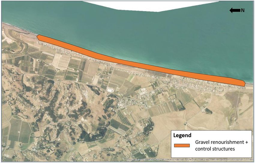
3.3.1 Westshore Short-term Adaptation Response
The Northern Assessment Panel identified the following preferred short, medium- and
long-term adaptation responses for the Westshore Priority Unit after completing the Stage
3 Evaluation Process as part of the Strategy:26
UNIT D: WESTSHORE – PATHWAY 3
Short-term Medium term Long term
→ →
(0 – 20 years) (20 – 50 years) (50 – 100 years)
Renourishment + Control Renourishment + Control
Renourishment → →
Structures Structures
Further modelling and engineering concept design for this priority unit has identified that
in the short-term, renourishment is likely to comprise of a combination of both sand and
gravel renourishment as well was the extension of the existing gravel barrier at Westshore
(Beya and Asmat, 2019).
For modelling and engineering concept design purposes, a 45m design distance was
assumed for the gravel barrier, ensuring approximately 5m of clearance is available
between the property boundary and the proposed barrier (Figure 6).
26
Section 8.4, Mitchell Daysh Limited, 2018. Report of the Northern and Southern Cell Assessment Panels.
Stage 4 Consentability of Short-Term Adaptation Responses – Clifton to Tangoio -
Coastal Hazard Strategy 2120 18Figure 6: Design gravel barrier used to inform modelling and engineering design
(Beya and Asmat, 2019).
Gravel barriers are only required in front of existing and future infrastructure that require
protection or in location where the existing barrier height is lower than the proposed new
gravel barrier crest height. Modelling identified that the portion of this Priority Unit where a
gravel barrier is required in the short-term is at the northern end of Westshore. This is
where houses and the road are close to the shore and where the existing barrier height is
less than the proposed new barrier (Figure 7).
Figure 7: Approximate areas of the Westshore priority unit were an extension to the
existing gravel barriers is required (Beya and Asmat, 2019).
Stage 4 Consentability of Short-Term Adaptation Responses – Clifton to Tangoio -
Coastal Hazard Strategy 2120 19Gravel and sand nourishment already take place at Westshore under two existing coastal
permits. HBRC currently holds a permit27 to undertake approximately 30,000m3/y of
renourishment in the Westshore area per year. The Port of Napier holds a permit28 to
dispose of dredged material off the coast of Westshore. Collectively these two consents
enable the ability for significant volumes of gravel and sand renourishment to occur in the
area, but those consents do not oblige the consent holders to compulsorily deposit
material for renourishment purposes.
HBRC is currently considering two potential engineering concept designs for Westshore.
Based on the larger of the two options the following renourishment activities will be
required to implement the short-term adaptation response for Westshore: 29 Note that
these figures assume that HBRC and the Port of Napier will utilise the maximum
renourishment potential of their consents.
Initial Works30
Construction of a 1.95km long gravel barrier along northern Westshore (Figure 7). The
gravel barrier will have a cross sectional area of approximately 5.4m 2 and will require
approximately 10,500m3 of gravel to construct.
Approximately 850,000m3 of sand renourishment. This is to be undertaken as part of
an initial capital works programme (over one to two years) and is in addition to the
1,000,000m3 of sand renourishment that could be undertaken by the Port of Napier.
Ongoing maintenance works (to maintain the sandy beach)31
Approximately 100,000m3/y of sand renourishment. This is in addition to the existing
33,500m3/y currently being deposited per year;
Approximately 3,500m3/y of gravel renourishment. This is in addition to the existing
gravel nourishment of 15,300m3/y being undertaken by HBRC.
Approximately 528m3/y of gravel associated with ongoing maintenance of the
Westshore Gravel Barrier.
27
Hawke’s Bay Regional Council Consent Number LU160261D and LU160262E. Both consents lapse on 34 May
2027.
28
Hawke’s Bay Regional Council Consent Number CD180012W.
29
Note that a number of modelling scenarios were developed for Westshore. Modelling Alternative B has been
evaluated as it requires most significant sand and gravel volumes and accordingly, carries the greatest
consenting risk. Note that based on discussions with Hawke’s Bay Regional Council (pers comm J Beya),
Alterative B or C are the most likely design scenario being considered at this time.
30
As part of Alternative B discussed in the Beya and Asmat, 2019. Design of Groynes and Nourishment – Clifton
to Tangoio 2120 Strategy – Stage 4 Wave, Shoreline Evolution and Gravel Barrier Response Modelling.
Groynes Design and Cost estimates. Note all volumes referred to in this section are derived from this report.
31
As part of Alternative B discussed in the Beya and Asmat, 2019. Design of Groynes and Nourishment – Clifton
to Tangoio 2120 Strategy – Stage 4 Wave, Shoreline Evolution and Gravel Barrier Response Modelling.
Groynes Design and Cost estimates. Note all volumes referred to in this section are derived from this report.
Stage 4 Consentability of Short-Term Adaptation Responses – Clifton to Tangoio -
Coastal Hazard Strategy 2120 20Approximately 686 m3/y of gravel per year to mitigate projected sea level rise.
The second engineering concept design 32 being considered by HBRC is a reduced version
of the above and excludes the 850,000m3 of initial sand nourishment and the associated
annual maintenance renourishment of 100,000m3/y.
3.3.2 Regional and District Planning Provisions
The Westshore priority unit is located within the jurisdiction of the HBRC and NCC.
Westshore Zoning
The areas of Westshore required to accommodate the proposed gravel barriers and
associated beach renourishment are located within the Foreshore Reserve Zone of the
City of Napier District Plan. This zone occupies much of the waterfront and is also overlaid
by the Coastal Hazard Zone. The width of the Foreshore Reserve Zone narrows along
northern Westshore and is immediately adjoined by the Northern Residential Zone.
The City of Napier District Plan also identifies two features of significance in this area - an
archaeological site33 associated with a military pill box and an archaeological site 34
associated with the remains of the former North British and Hawke‘s Bay Freezing
Company (established in 1888).
32
As part of Alternative C discussed in the Beya and Asmat, 2019. Design of Groynes and Nourishment –
Clifton to Tangoio 2120 Strategy – Stage 4 Wave, Shoreline Evolution and Gravel Barrier Response
Modelling. Groynes Design and Cost estimates. Note all volumes referred to in this section are derived from
this report.
33
Archaeological Site, Pill Box, Reference V21/259.
34
Archaeological Site, Freezing Works, Reference V21/260.
Stage 4 Consentability of Short-Term Adaptation Responses – Clifton to Tangoio -
Coastal Hazard Strategy 2120 21An overview of the key zones that apply to this area under the City of Napier District Plan
is provided in Figure 8.
Figure 8: Zoning of the Westshore Priority Unit and surrounds under the Napier
District Plan.
Under the Hawke’s Bay Regional Coastal Environment Plan (“Regional Coastal
Environment Plan”), the proposed gravel barriers and renourishment areas are all located
within the Coastal Environment. The foreshore area is also subject to the “Westshore
Renourishment Area” overlay, with the large “Dredge Disposal Area” overlay located
immediately offshore. The seaward area of Westshore is subject to a CR(HB) Water
classification. There are currently no coastal hazard zones identified in the Regional
Coastal Environment Plan for the Westshore to Bay View coastline.
Stage 4 Consentability of Short-Term Adaptation Responses – Clifton to Tangoio -
Coastal Hazard Strategy 2120 22An overview of the key zones that apply to this site Regional Coastal Environment Plan is
provided in Figure 9. The HBRC Hazards Portal also contains update to date mapping on
coastal hazards within this area. 35
Figure 9: Zoning of the Westshore Priority Unit and surrounds under the Hawke’s Bay
Regional Coastal Environment Plan.
35
https://hbmaps.hbrc.govt.nz/hazards/
Stage 4 Consentability of Short-Term Adaptation Responses – Clifton to Tangoio -
Coastal Hazard Strategy 2120 23Key Environmental Values at Westshore
The key environmental values at and in the vicinity of the Westshore priority unit are set
out below.
The relevant District and Regional Plans do not currently identify any areas of
significant ecological, landscape or character value at, or surrounding, the Westshore
priority unit.36
As identified on the HBRC Pātaka mapping resource, the area lies within the Ngati
Kahungunu iwi boundary and Te Taiwhenua O Te Whanganui-a-Orotū. The Treaty
Partner Land Area associated with Mana Ahuriri also overlays the landward area and
the Kahungunu ki Te Matau a Māui Rohe Moana over the coastal area.
Offshore reefs, including Te Pania are of cultural significance in this area.37
The southern end of Westshore includes two features of historical significance - an
archaeological site38 associated with a military pill box and an archaeological site 39
associated with the remains of the former North British and Hawke’s Bay Freezing
Company (established in 1888).
The area is valued for its recreational amenities, including green verges, cycleway and
walkway and local surf club. The Surf Club has approximately 350 members.40
Historically post the 1931 Hawke’s Bay earthquake, the area comprised of a sandy
beach. Many residents would like to see the sandy beach restored and the amenity
value maintained by rebuilding the beach and nearshore area with sand which has
eroded over the past 20-30 years.41
The Rangatira Reef (or City Reef) is located at the southern end of Westshore,
adjacent to Whakarire Avenue. The reef creates a good quality surf break in the area
in certain wave conditions.
Recreational diving and fishing are important in the Napier Coastal Environment,
particularly around the offshore Pania Reef.
36
Note the City of Napier District Plan is currently being reviewed, with the proposed plan due for notification
mid-2021. Due to timing, this report does not take the proposed plan into account as it does not currently
have any legal status. The consentability of the three Priority Units within the Napier City District may
therefore need to be reviewed into the future.
37
As identified as part of the Stage 3 of the multi-criteria decision-making analysis process for the Northern
Assessment Panel. Criteria specifically related to the relationships of Maori and their culture and traditions
with their ancestral lands, water, sites waahi tapu and other taonga.
38
Archaeological Site, Pill Box, Reference V21/259.
39
Archaeological Site, Freezing Works, Reference V21/260.
40
Marven Consulting, 2017. Coastal Hazards and Social Impact Assessment and Valuation for Ahuriri/Pandora,
Westshore, Bay View and Whirinaki.
41
Marven Consulting, 2017. Coastal Hazards and Social Impact Assessment and Valuation for Ahuriri/Pandora,
Westshore, Bay View and Whirinaki.
Stage 4 Consentability of Short-Term Adaptation Responses – Clifton to Tangoio -
Coastal Hazard Strategy 2120 24The site is located within the Westshore Beach Reserve. This is a reserve under the
Reserves Act 1977 for Recreation Reserve purposes.
A resource consent has recently been approved for the construction of a rock
revetment and wave spending beach at the southern end of Westshore immediately
seaward of the residential dwellings fronting the ocean along Whakarire Avenue (refer
to case study in section 6.1). NCC is currently consulting on its construction as part of
the Annual Plan.
Likely Resource Consents Required
The likely resource consents required to implement the short-term adaptation responses
at Westshore are set out in Table 4. The resource consent currently held by HBRC for up
to 30,000m3 of renourishment will not cover the full gambit of short-term adaptation
responses via renourishment works at Westshore, and certainly not beyond 2027 when
the consents expire.
The proposed extension to the gravel barrier at Westshore will likely require resource
consent as a controlled activity under the Regional Coastal Environment Plan. Controlled
activities must be granted. The offshore (below mean high water spring) renourishment
activities will likely require resource consent as a full discretionary activity.
Based on the information available, no resource consents are required under the City of
Napier District Plan as the removal and/or deposition of sediment and/or beach single
above mean high water springs is a permitted activity provided the maximum deposition
rate does not 50,000m3/year and the activity must relate to renourishment within the
Foreshore Reserve Zone.42
Table 4: Summary of likely consent requirements at Westshore. Blue shading
identifies consents required from the HBRC.
Consent Requirement Activity Status
Renourishment resulting in deposition of material on the Discretionary43
foreshore or seabed in quantities greater than 50,000m3.
Beach renourishment44 within Westshore Renourishment Area. Controlled45
42
Rule 44.6, City of Napier District Plan.
43
Rule 151, Hawke’s Bay Regional Coastal Environment Plan.
44
Beach nourishment means the placement of sediment by artificial means on the foreshore, seabed, or active
beach area for the purposes of mitigating a coastal hazard or for maintaining shoreline location. Usually the
imported material is of similar physical characteristics to the material already present. Beach nourishment is
most commonly carried out as a coastal protection work. It is not a reclamation because its primary purpose
is not to create new land; and does not include the dumping of waste or other material.
45
Rule 103, Hawke’s Bay Regional Coastal Environment Plan.
Stage 4 Consentability of Short-Term Adaptation Responses – Clifton to Tangoio -
Coastal Hazard Strategy 2120 253.4 PANDORA
3.4.1 Pandora Short-term Adaptation Response
The Northern Assessment Panel identified the following preferred short, medium- and
long-term adaptation responses for the Pandora priority unit as part of the Stage 3
Evaluation Process of the Strategy:46
UNIT E2: PANDORA – PATHWAY 3
Short-term Medium term Long term
→ →
(0 – 20 years) (20 – 50 years) (50 – 100 years)
Inundation Protection → Inundation Protection → Inundation Protection
Further modelling and engineering concept design for this priority unit has identified that
in the short-term, a range of inundation protection measures will be required reflective of
the broad ranging environmental settings along the proposed feature. This includes
stopbanks, revetments and sheet pile walls. The composition of the inundation protection
features is shown in Figure 10.
46
Section 8.3, Mitchell Daysh Limited, 2018. Report of the Northern and Southern Cell Assessment Panels.
Stage 4 Consentability of Short-Term Adaptation Responses – Clifton to Tangoio -
Coastal Hazard Strategy 2120 26Figure 10: Layout design for the proposed flood defences in the Pandora Priority Unit
(Beya and Asmat, 2020).
Stop banks are proposed to be used in three locations, including:
A 1070m stop bank (Stop bank 1) located between the western railway and Tyne
Street Drain.
A 190m stop bank (Stop bank 2) located across the Humber Street Reserve; and,
A 180m long stop bank (Stop bank 3) located directly south of the Napier Sailing Club.
A typical stop bank cross section is shown in Figure 11. Provided the foundations are
developed with enough bearing capacity, the future crest height of the stop banks can be
incrementally increased in response to rising sea levels.
Figure 11: Typical stop bank cross section (Beya and Asmat 2020).
Stage 4 Consentability of Short-Term Adaptation Responses – Clifton to Tangoio -
Coastal Hazard Strategy 2120 27A 204m sheet pile wall with an approximate design crest height of 12.9m is proposed
adjacent to the Tyne Street Drain (Figure 12). The sheet pile was identified for this area
due to the scarcity of space along this frontage.
Figure 12: Sheet pile ground levels crest height (Beya and Asmat, 2020).
The remainder of the inundation protection will comprise of revetments backed with a
cantilevered reinforced concrete wall (Figure 13). The revetments include:
A 110m long revetment along Pandora Pond (in the vicinity of the existing car-tyre
revetment); and,
A 130m long revetment in place of the existing rock revetment along West Quay.
The proposed revetments would increase the crest height of existing revetments by 1.45m
and 0.9m respectively.
Figure 13: Typical design cross section of cantilevered reinforced concrete wall and
revetment (Beya and Asmat, 2020).
Works will be required to raise the height of Pandora Road to ensure it does not create a
low point in the inundation protection network.
Stage 4 Consentability of Short-Term Adaptation Responses – Clifton to Tangoio -
Coastal Hazard Strategy 2120 28As an alternative option to the inundation protection measures, consideration has been
given to the installation of a storm surge barrier. The inflatable tube barrier would be
installed at the entrance to the Ahuriri Harbour, extending approximately 100m in width.
The approximate location of the proposed storm surge barrier is shown in Figure 14. This
was not an option considered as part of the Stage 3 Assessment Panel process but has
been identified in the concept engineering and design report.
Figure 14: Approximate location and length of storm surge barrier (Beya and Asmat,
2020).
3.4.2 Regional and District Planning Provisions
The Pandora Unit is located within the jurisdiction of the HBRC and NCC.
Pandora Zoning
The Pandora priority unit traverses a number of land use zones within the City of Napier
District Plan (Figure 15). A large area of Mixed-Use zoning is located between West Quay
and the Tyne Street Drain (perpendicular to Humber Street). The drain itself is zoned
Reserve, with the area north and west of the drain (i.e. the Ahuriri Estuary) zoned Estuary.
The land behind the Reserve zoned drains is zoned Main Industrial.
The southern abutments of the designated railway bridge, near where the proposed
seawall would attach to land, is zoned for Rural Conservation purposes.
Stage 4 Consentability of Short-Term Adaptation Responses – Clifton to Tangoio -
Coastal Hazard Strategy 2120 29The area in front of West Quay and up to and including the Pandora Bridge is zoned Boat
Harbour. This includes the Sailing Club.
An overview of the key zones that apply to this area under the City of Napier District Plan
is provided in Figure 15.
Figure 15: Zoning of the Pandora Unit and surrounds under the City of Napier District
Plan.
Under the Regional Coastal Environment Plan, the proposed inundation protection
measures are all located within the Coastal Environment – some more specifically in parts
of the coastal marine area.
The area around the Pandora Marina is located within the Port Management Zone
(between West Quay and Pandora Road). To the west of Pandora Road, parts of the
proposed inundation protection measures are located within Significant Conservation Area
12 and Class CR (HB) Water.
An overview of the key zones that apply to this area under the Regional Coastal
Environment Plan is provided in Figure 16. The HBRC Hazards Portal also contains update
to date mapping on coastal hazards within this area. 47
47
https://hbmaps.hbrc.govt.nz/hazards/
Stage 4 Consentability of Short-Term Adaptation Responses – Clifton to Tangoio -
Coastal Hazard Strategy 2120 30Figure 16: Zoning of the Pandora Unit and surrounds under the Hawke’s Bay Regional
Coastal Environment Plan.
Key Environmental Values
The key environmental values at and in the vicinity of the Pandora priority unit are set out
below.
As identified on the HBRC Pātaka mapping resource, the area lies within the Ngati
Kahungunu iwi boundary and Te Taiwhenua O Te Whanganui-a-Orotū. The Treaty
Partner Land Area associated with Mana Ahuriri also overlays the landward area and
the Kahungunu ki Te Matau a Māui Rohe Moana over the coastal areas.
Waka access to lagoon and the sea and fish passage is of particular cultural
importance in this area.48
The Ahuriri Estuary supports over 70 bird species, some critically endangered native
species and some migratory birds from the northern hemisphere. Of note are the
critically endangered Bittern and the flounder and cockle species. The lower estuary a
known yellow belly flounder species nursery.49
Pandora Pond is used as an entry point for waka and is also used by recreational
swimmers. Several walkways and trails can also be found around the estuary and
former lagoon. 50
48
As identified as part of the Stage 3 of the multi-criteria decision-making analysis process for the Northern
Assessment Panel. Criteria specifically related to the relationships of Maori and their culture and traditions
with their ancestral lands, water, sites waahi tapu and other taonga.
49
Ahuriri Estuary and Coastal Edge Master Plan, prepared by Napier City Council, Isthmus and Mitchell Daysh,
July 2018.
50
Coastal Hazards and Social Impact Assessment and Valuation for Ahuriri/Pandora, Westshore, Bay View and
Whirinaki, prepared by Marven Consulting, July 2017.
Stage 4 Consentability of Short-Term Adaptation Responses – Clifton to Tangoio -
Coastal Hazard Strategy 2120 31The Ahuriri Estuary and Coastal Edge Master Plan seeks to increase the recreational
values further through the development of additional tracks and interpretation
signage. The Master Plan also proposes to establish Humber Reserve (located north
of Humber Street) as a “Premier recreation reserve”. 51
The Humber Reserve is located north of Humber Road. This is a reserve under the
Reserves Act 1977 for Local Purpose and Recreation reserve.
The estuary forms an important part of the stormwater network and receives
approximately 70% of the city’s untreated stormwater. 52
Likely Resource Consents Required
The likely resource consents required to implement the short-term adaptation response at
Pandora is set out in Table 5.
A number of resource consents are required from the HBRC as coastal hazard mitigation
works are not captured by a single rule, rather they must be considered in their individual
parts. Overall, resource consents for both HBRC and NCC will likely be ‘bundled’, with an
overall activity status of non-complying. Separate applications could be made however to
ensure the NCC consent retains its discretionary status.
As discussed later in section 5, part of the proposal may also be prohibited within the
Significant Conservation Area. No consent can be sought for such activities.
Table 5: Summary of likely consent requirements at Pandora. Blue shading identifies
consents required from the HBRC, while green shading identifies consents
required from NCC.
Consent Requirement Activity Status
Soil disturbances (i.e. earthworks) and potentially vegetation Restricted Discretionary.53
removal within the coastal margin and less than 20m of the
coastal marine area
The discharge of solid contaminants, including clean fill in the Discretionary54
coastal margin that may enter water
Discharge of contaminants in the coastal margin Discretionary55
51
Napier City Council, Isthmus and Mitchell Daysh, 2018. Ahuriri Estuary and Coastal Edge Master Plan.
52
Napier City Council, Isthmus and Mitchell Daysh, 2018. Ahuriri Estuary and Coastal Edge Master Plan.
53
Rule 8, Hawke’s Bay Regional Coastal Environment Plan.
54
Rule 18, Hawke’s Bay Regional Coastal Environment Plan.
55
Rule 9, Hawke’s Bay Regional Coastal Environment Plan.
Stage 4 Consentability of Short-Term Adaptation Responses – Clifton to Tangoio -
Coastal Hazard Strategy 2120 32Consent Requirement Activity Status
Disturbance of the foreshore and seabed associated with the Discretionary56
construction of the coastal protection structure within the
coastal marine area.
The construction and placement of a coastal protection Non-complying58
structure57 in the coastal marine area which presents a
significant barrier to water, is established parallel to mean
high water sprints and extends for 300m or more
(cumulative).
The occupation of the coastal marine by coastal protection Discretionary59
structures (including storm surge barriers).
The damming and diversion of coastal water. Discretionary60
The establishment of a wave structure in the coastal marine Discretionary61
area.
The erection or placement of any structure in the coastal Prohibited62
marine area that would impound or effectively contain the
coastal marine area in the Significant Conservation Areas of
the Ahuriri Estuary (SCA12).
Coastal Protection Structures within the Boat Harbour, Discretionary63
Estuary, Reserve and Mixed-Use Zones.
The erection of structures crossing mean high water spring. Discretionary64
Development or land use that does not comply with the Restricted Discretionary65
relevant conditions (i.e. height, height in relation to boundary,
yards, noise and vibration and earthworks) in the Boat
Harbour, Estuary, Reserve and Mixed-Use Zones.
The removal of greater than 100m3 of earth within a 12-month Discretionary66
period from any zone.
56
Rule 130, Hawke’s Bay Regional Coastal Environment Plan.
57
Coastal Protection Works means any works used to reduce risks posed by coastal erosion and/or inundation
by the sea to human life, property, or the environment and includes coastal protection structures and beach
nourishment.
58
Rule 125, Hawke’s Bay Regional Coastal Environment Plan.
59
Rule 178, Hawke’s Bay Regional Coastal Environment Plan.
60
Rule 155, Hawke’s Bay Regional Coastal Environment Plan.
61
Rule 117, Hawke’s Bay Regional Coastal Environment Plan.
62
Rule 128, Hawke’s Bay Regional Coastal Environment Plan.
63
Rule 42.8(e), Rule 43.7(a) and (e) and Rule 46.7.1(a) and (f), City of Napier District Plan.
64
Rule 42.8(a), 42.8.1(a) and 43.7.1(a), City of Napier District Plan.
65
Rules 42.7, 43.6, 50A.26 and 46.6, City of Napier District Plan.
66
Rule 5A.10, City of Napier District Plan.
Stage 4 Consentability of Short-Term Adaptation Responses – Clifton to Tangoio -
Coastal Hazard Strategy 2120 33You can also read