Town of Los Gatos Green Stormwater Infrastructure Plan
←
→
Page content transcription
If your browser does not render page correctly, please read the page content below
Town of Los Gatos
       Green Stormwater Infrastructure Plan

Approved on: August 20, 2019
Approved by: The Town Council of the Town of Los Gatos

Prepared by:
Town of Los Gatos
110 East Main Street
Los Gatos, CA 95030
In compliance with Provision C.3.j.i.(2) of Order R2-2015-0049, NPDES Permit No. CAS612008
ACKNOWLEDGEMENTS
The Town of Los Gatos gratefully acknowledges the following individuals and organizations that
contributed to this Green Stormwater Infrastructure Plan:

Town of Los Gatos

    Parks and Public Works Department

        •   Jim Harbin
        •   Mike Weisz, P.E

West Valley Clean Water Authority

        •   Sheila Tucker
        •   Julie Schaer

EOA, Inc.

        •   Jill Bicknell, P.E.
        •   Vishakha Atre
        •   Liesbeth Magna

The Town would like to thank and acknowledge the City of Palo Alto, City of San Jose and City of
Campbell for sharing text from their Green Stormwater Infrastructure Plans.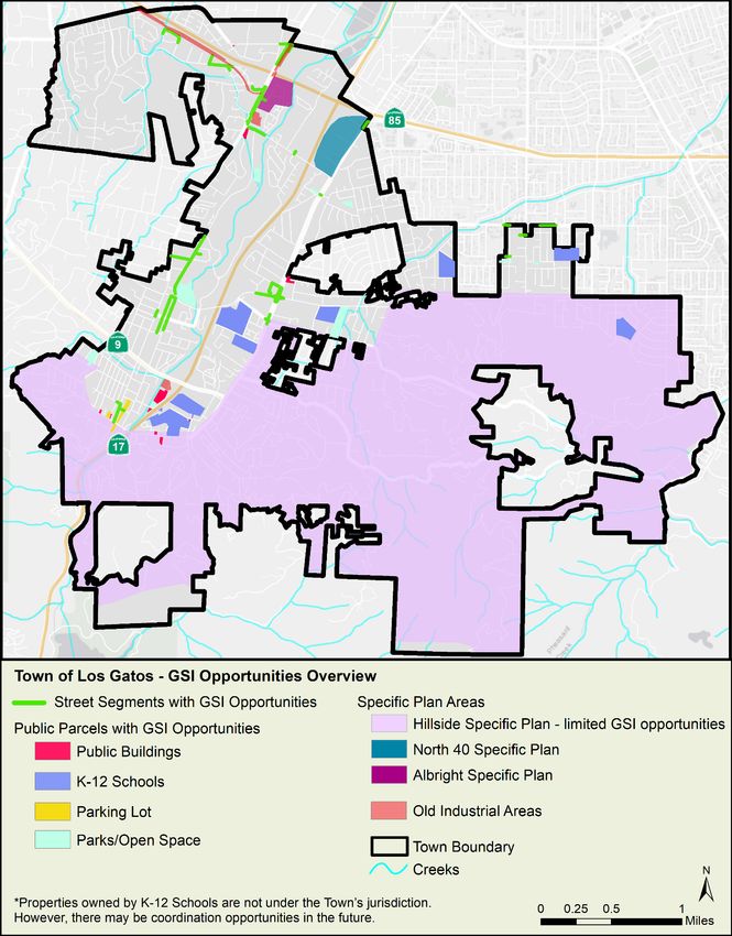
Town of Los Gatos

Table of Contents
EXECUTIVE SUMMARY .................................................................................................................................. v
1.     INTRODUCTION ..................................................................................................................................... 1
              Purpose and Goals of the GSI Plan................................................................................................ 1
              Town Description .......................................................................................................................... 1
       1.2.1         Land Use ................................................................................................................................ 2
       1.2.2         Population and Growth Projections...................................................................................... 2
       1.2.3         Transportation and Street Types: ......................................................................................... 3
       1.2.4         Water Resources and Water Supply: .................................................................................... 3
       1.2.5         Flood Potential ...................................................................................................................... 3
       1.2.6         Stormwater Drainage System: .............................................................................................. 4
       1.2.7         Open Space, Agriculture and Vacant Land:........................................................................... 4
              Regulatory Context ....................................................................................................................... 4
       1.3.1         Federal and State Regulations and Initiatives....................................................................... 4
       1.3.2         Municipal Regional Stormwater Permit................................................................................ 5
              GSI Plan Development Process ..................................................................................................... 6
       1.4.1         Regional Collaboration .......................................................................................................... 6
       1.4.2         GSI Plan Development and Adoption.................................................................................... 6
       1.4.3         Education and Outreach ....................................................................................................... 7
              GSI Plan Structure and Required Elements ................................................................................... 8
2.     WHAT IS GREEN STORMWATER INFRASTRUCTURE? .......................................................................... 10
              Green Stormwater Infrastructure ............................................................................................... 10
              Benefits of Green Stormwater Infrastructure............................................................................. 10
              Types of Green Stormwater Infrastructure Facilities.................................................................. 11
       2.3.1         Biotreatment/Bioretention ................................................................................................. 11
       2.3.2         Stormwater Tree Well Filters and Suspended Pavement Systems ..................................... 11
       2.3.3         Pervious Pavement ............................................................................................................. 12
       2.3.4         Infiltration Facilities ............................................................................................................ 13
       2.3.5         Green Roofs......................................................................................................................... 13
       2.3.6         Rainwater Harvesting and Use ............................................................................................ 14
3.     INTEGRATION WITH OTHER PLANNING DOCUMENTS ....................................................................... 15
              Town Planning Document Review .............................................................................................. 15
       3.1.1         General Plan ........................................................................................................................ 15
       3.1.2         Sustainability Plan ............................................................................................................... 15

                                                                              i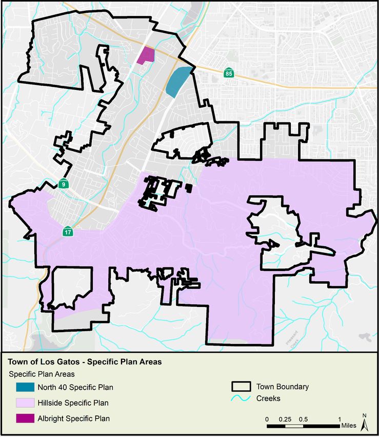
Town of Los Gatos

     3.1.3         Bicycle and Pedestrian Master Plan .................................................................................... 16
     3.1.4         North Forty Specific Plan..................................................................................................... 16
     3.1.5         Hillside Specific Plan............................................................................................................ 16
     3.1.6         Albright Specific Plan .......................................................................................................... 16
            Workplan for Integrating GSI Language into Existing and Future Town Planning Documents .. 16
            Regional Plans ............................................................................................................................. 17
     3.3.1         Santa Clara Basin Stormwater Resource Plan ..................................................................... 17
     3.3.2         Valley Water’s One Water Plan........................................................................................... 17
     3.3.3         Bay Area Integrated Regional Water Management Plan .................................................... 18
4.   GSI DESIGN GUIDELINES, DETAILS, AND SPECIFICATIONS .................................................................. 19
            Design Guidelines........................................................................................................................ 19
            Details and Specifications ........................................................................................................... 19
            Incorporation of SCVURPPP Details and Specifications into Town Standards............................ 19
5.   GSI PROJECT PRIORITIZATION AND IMPERVIOUS TARGETS ............................................................... 21
            Project Types ............................................................................................................................... 21
     5.1.1         Early Implementation Projects............................................................................................ 21
     5.1.2         Regulated Projects .............................................................................................................. 21
     5.1.3         LID Projects ......................................................................................................................... 21
     5.1.4         Regional Projects................................................................................................................. 21
     5.1.5         Green Street Projects .......................................................................................................... 22
            Identification and Prioritization Process ..................................................................................... 22
     5.2.1         Step 1: Stormwater Resource Plan Prioritization ............................................................... 22
     5.2.2         Step 2: Town-Specific Prioritization .................................................................................... 26
     Specific Plan Areas .............................................................................................................................. 26
     Green Stormwater Infrastructure in Industrial Areas ......................................................................... 26
            Prioritization Output ................................................................................................................... 26
6.   GSI IMPLEMENTATION PLAN .............................................................................................................. 30
            Town-wide GSI Strategy .............................................................................................................. 30
            Process for Identifying and Evaluating GSI Project Opportunities ............................................. 30
            Workplan for Early Implementation Projects ............................................................................. 31
            Legal Mechanisms for GSI Implementation ................................................................................ 31
            Evaluation of Funding Options .................................................................................................... 32
     6.5.1         Current Funding Sources for GSI Program Elements .......................................................... 32
     6.5.2         Potential Future Funding Options ....................................................................................... 32
            Impervious Area Targets ............................................................................................................. 37
     6.6.1         Methodology ....................................................................................................................... 37
     6.6.2         Results ................................................................................................................................. 37

                                                                            ii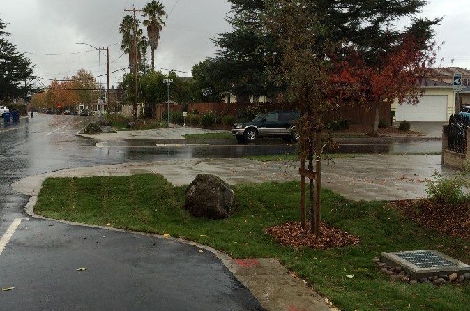
Town of Los Gatos

       6.6.3           Impervious Surface Retrofit Targets ................................................................................... 38
               Project Tracking System .............................................................................................................. 41
       6.7.1           SCVURPPP Project Tracking System .................................................................................... 41
       6.7.2           Town Project Tracking System (Regulated and GSI) ........................................................... 41

LIST OF TABLES

Table 1-1 Land Uses within the Town of Los Gatos ...................................................................................... 2
Table 1-2 Summary of GSI Plan Elements required by Provision C.3.j.i of the MRP .................................... 8
Table 5-1 Screening factors for parcel-based and right-of-way project opportunities .............................. 23
Table 6-1 Potential GSI Funding Options .................................................................................................... 33
Table 6-2 Projected cumulative land area (acres) anticipated to be addressed via GSI facilities via private
redevelopment in the Town of Los Gatos by 2020, 2030, and 2040 .......................................................... 38
Table 6-3 Actual (2002-2018) and predicted (2019-2040) extent of impervious surface retrofits via GSI
implementation on private and public parcels in the Town of Los Gatos by 2020, 2030, and 2040 ......... 40

LIST OF FIGURES

Figure 2-1 Stormwater curb extension, Hacienda Avenue, Campbell (Source: City of Campbell) ............. 11
Figure 2-2 Stormwater tree well filter conceptual examples: modular suspended pavement system (left),
column suspended pavement system (right). (Courtesy of City of Philadelphia Water Department)....... 12
Figure 2-3 Permeable Pavers, Mayfield Playing Fields, Palo Alto (Source: City of Palo Alto) ..................... 12
Figure 2-4 Infiltration trench, San Jose (Source: City of San Jose) .............................................................. 13
Figure 2-5 Subsurface infiltration system, (Source: Conteches.com) ......................................................... 13
Figure 2-6 Green Roof at Fourth Street Apartments, San Jose (Source: EOA) ........................................... 13
Figure 2-7 Rainwater Harvesting cistern, Environmental Innovation Center, San Jose (Source: City of San
José) ............................................................................................................................................................ 14
Figure 2-8 Subsurface vault for rainwater harvesting, under construction (Source: Conteches.com) ...... 14
Figure 5-1 Town of Los Gatos Public Parcels and Street Segments with GSI Opportunities (Source: Santa
Clara Basin SWRP) ....................................................................................................................................... 25
Figure 5-2 Town of Los Gatos Specific Plan Areas (Source – Town of Los Gatos General Plan) ................. 27
Figure 5-3 Town of Los Gatos Old Industrial Areas (industrial areas developed prior to 1980) (Source:
SCVURPPP) .................................................................................................................................................. 28
Figure 5-4 Town of Los Gatos GSI Opportunities Overview........................................................................ 29
Figure 6-1. Existing and projected cumulative land area (acres) anticipated to be addressed via GSI
facilities installed via private redevelopment in the Town of Los Gatos by 2020, 2030, and 2040 ........... 38

LIST OF APPENDICES
Appendix A – GSI Project Prioritization Metrics
Appendix B – Street Segments and Parcels in Los Gatos with Opportunities for GSI
Appendix C – Guidance for Identifying Green Infrastructure Potential in Municipal Capital Improvement
             Program Projects

                                                                                 iii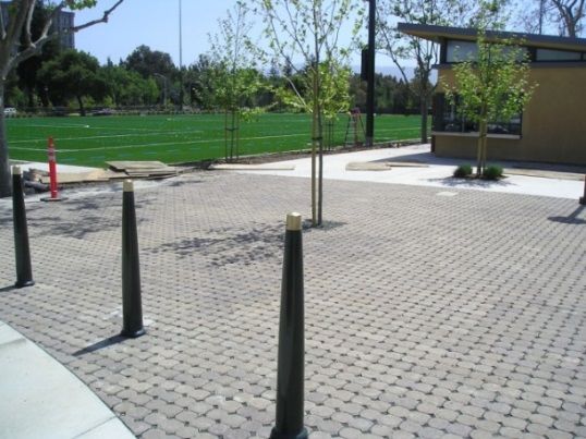
Town of Los Gatos

LIST OF ACRONYMS
ABAG                   Association of Bay Area Governments
BASMAA                 Bay Area Stormwater Management Agencies Association
BPMP                   Los Gatos Bicycle and Pedestrian Master Plan
Caltrans               California Department of Transportation
CASQA                  California Stormwater Quality Association
CIP                    Capital Improvement Program
DOF                    California Department of Finance
EIR                    Environmental Impact Report
EPA                    Environmental Protection Agency
FY                     Fiscal Year
GI                     Green Infrastructure
GHG                    Greenhouse Gas
GIS                    Geographic Information System
GSI                    Green Stormwater Infrastructure
IRWMP                  Bay Area Integrated Regional Water Management Plan
LID                    Low Impact Development
MRP                    Municipal Regional Stormwater NPDES Permit
MS4                    Municipal Separate Storm Sewer System
MTC                    Metropolitan Transportation Commission
NPDES                  National Pollutant Discharge Elimination System
O&M                    Operation and Maintenance
PDA                    Priority Development Areas
PCBs                   Polychlorinated Biphenyls
PICP                   Permeable Interlocking Concrete Pavers
PP                     Permeable Pavers
Regional Water Board   San Francisco Bay Regional Water Quality Control Board
SCVURPPP               Santa Clara Valley Urban Runoff Pollution Prevention Program
SJWC                   San Jose Water Company
State Water Board      State Water Resources Control Board
STORMS                 Strategy to Optimize Resource Management of Stormwater
SWRP                   Storm Water Resource Plan
SWRCB                  State Water Resource Control Board
Town                   Town of Los Gatos
Valley Water           Santa Clara Valley Water District
Water Board            San Francisco Bay Regional Water Quality Control Board
WVCWA                  West Valley Clean Water Authority

                                                      iv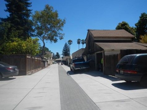
Town of Los Gatos

EXECUTIVE SUMMARY
The purpose of the Town of Los Gatos’ (Town) Green Stormwater Infrastructure (GSI) Plan is to describe
how the Town will gradually integrate GSI features into its urban landscape and stormwater conveyance
systems over several decades. GSI uses vegetation, soils, and natural processes to manage stormwater
runoff by utilizing “Low Impact Development” (LID) measures for a more sustainable storm drain system
comprised of “green” infrastructure, allowing runoff to soak into the ground and be filtered by soil via
infiltration. These facilities and features capture, store and treat stormwater using natural processes
and recreates the predevelopment hydrology and landscape features of a particular project site.

The Town, as with other municipalities and agencies in the San Francisco Bay Area, is subject to the
requirements of the Municipal Regional Stormwater National Pollutant Discharge Elimination System
Permit (MRP), which became effective on January 1, 2016. Provision C.3.j of the MRP requires that
Permittees develop and implement a long-term GSI Plan for the inclusion of GSI measures into storm
drain infrastructure on public and (sometimes) private property, including streets, roads, parking lots,
roofs, and other elements. This Plan must also demonstrate the Town’s long-term commitment to GSI
implementation to help reduce loads of pollutants of concern (e.g., mercury and PCBs) discharged to
local waterways (per MRP requirements). The Plan must be completed, approved and submitted to the
San Francisco Bay Regional Water Quality Control Board by September 30, 2019.

This Plan describes the Town’s methodology to identify and prioritize areas for implementing GSI and
estimates targets for the extent of the Town’s area that will be addressed by GSI through the year 2040.
The Plan includes maps of the Town’s potential project opportunities and lays out the Town’s GSI
implementation strategy. Key mechanisms of the strategy include coordination with GSI regulations for
private development projects to identify opportunities in adjacent public rights-of-way; identification of
GSI opportunities in capital improvement projects; and aligning GSI goals and policies with other Town
planning documents to achieve multiple benefits while also providing safer, sustainable, and attractive
public streetscapes. The Plan contains guidance and standards for GSI project design and construction
and describes how the Town will track and map constructed GSI projects while also making the
information available to the public. Lastly, it explains existing legal mechanisms for implementation of
the GSI Plan, and identifies potential sources of funding for the design, construction, and maintenance
of GSI projects.

                                                    v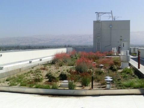
Town of Los Gatos

1.        INTRODUCTION
Urban development has traditionally involved replacing natural landscapes with solid pavements and
buildings, and using storm drain systems to carry increased amounts of stormwater runoff and
pollutants directly into local streams. Green stormwater infrastructure (GSI), however, uses plants and
soils to mimic natural watershed processes, capture stormwater and create healthier environments. Bay
Area cities and counties are required by State and regional regulatory agencies to move from traditional
(grey) stormwater conveyance systems to GSI systems over time. This GSI Plan serves as an
implementation guide for the Town of Los Gatos (Town) to incorporate GSI into storm drain
infrastructure on public and private lands where feasible over the next several decades.

          Purpose and Goals of the GSI Plan
The purpose of the Town’s GSI Plan is to demonstrate the Town’s commitment to gradually transform its
traditional storm drainage infrastructure to green stormwater infrastructure. The GSI Plan will guide the
identification, implementation, tracking, and reporting of green stormwater infrastructure projects
within the Town. The GSI Plan will be coordinated with other Town plans, such as the General Plan, Safe
Routes to School Report and the Bicycle and Pedestrian Master Plan, to achieve multiple potential
benefits to the community, including improved water and air quality, reduced local flooding, increased
water supply, traffic calming, safer pedestrian and bicycle facilities, climate resiliency, improved wildlife
habitat, and a more pleasant urban environment.
Specific goals of the GSI Plan are to:

     •    Align the Town’s goals, policies and implementation strategies for GSI with the General Plan and
          other related planning documents;
     •    Identify and prioritize GSI opportunities throughout the Town;
     •    Establish targets for the extent of Town area to be addressed by GSI over certain timeframes;
     •    Provide a workplan and legal and funding mechanisms to implement prioritized projects; and
     •    Establish a process for tracking, mapping, and reporting completed projects

          Town Description
The Town of Los Gatos occupies approximately 11.5 square miles and is located approximately fifty (50)
miles south of San Francisco in Santa Clara County. Los Gatos is bounded on the north by the City of
Campbell, south by the Santa Cruz Mountains and unincorporated Santa Clara County, east by the City
of San Jose and west by the Cities of Monte Sereno and Saratoga. Los Gatos is characterized by hilly
terrain located on the lower slope of the Santa Cruz Mountains at an elevation of 344 feet.

The Town incorporated in 1887 and has a jurisdictional area of 7,335 acres. In 2010, the Town had a
population of 30,802, with a population density of 2,635 people per square mile and average household
size of 2.35. As of 2019, according to the California Department of Finance (DOF) 1, the estimated
population for Los Gatos is 30,988.

1
  Source: State of California, Department of Finance, E-1 Population Estimates for Cities, Counties and the State with Annual Percent Change —
January 1, 2018 and 2019. Sacramento, California, May 2018. Online at http://www.dof.ca.gov/Forecasting/Demographics/Estimates/e-1/.
                                                                      1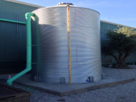
Green Stormwater Infrastructure Plan

Los Gatos is home to Netflix, Roku and over 3,700 businesses, which serve residents and draw visitors to
the restaurants, hotels, and shops within a pedestrian-oriented downtown setting. The Town provides
excellent schools, a vibrant Downtown, dynamic neighborhood and diverse shopping experiences and
also features many parks and greenbelt areas. Downtown Los Gatos is listed on the National Register of
Historic Places and is the model of what communities strive to achieve in a downtown. Additional Town
characteristics are provided in the following subsections.

1.2.1 Land Use
Los Gatos is predominantly built-out. Land uses within the Town, as defined in the General Plan, are
provided in Table 1-1. The Town is primary comprised of low-density residential land uses. Los Gatos has
approximately 4,329 acres of woodland/forest communities, including riparian woodlands, oak
woodlands, broadleaved upland forest, and non-native ornamental trees, that support a very green
environment. Other land uses include commercial, office, light industrial, K-12 schools, open space and
urban parks.
Table 1-1 Land Uses within the Town of Los Gatos

   Land Use Category                           Acres         Percent of Town
                                                                 Acreage

  Residential – Single Family                5,911              51.2%
  Residential – Multi-Family                  407               6.5%
  Commercial                                  164               2.6%
  Office Professional                         126                2%
  Light Industrial                            37                0.6%
  Public/Quasi-Public                         440               4.7%
  Public Utilities                            39                0.5%
  Agricultural                                112                1%
  Open Space/Recreation                      3,841              26.2%
  Vacant                                      399               4.7%
  Total                                     11,476              100%

1.2.2 Population and Growth Projections
The Town of Los Gatos is primarily a built-out community with few opportunities for new large-scale
development to occur. The Town established growth/development forecasts as part of its General Plan
Environmental Impact Report (EIR). The population growth of Los Gatos has remained fairly small and
stable in the last three (3) decades.
Since 2010, the Town has experienced an annual growth rate of 0.5 percent with a total increase of less
than 1,200 persons during that time, which is lower than the County’s rate of 1.2 percent. Similarly,
according to the DOF, the housing stock in Los Gatos has grown by 250 units during this same

                                                       2
Green Stormwater Infrastructure Plan

timeframe, an increase of approximately 0.2 percent on an annual basis. This, again, is lower than the
increase in new housing in the County which saw an annual rate of 0.7 percent since 2010.
According to Plan Bay Area 2040, a regional transportation and land use roadmap for future growth
adopted jointly by the Association of Bay Area Governments (ABAG) and the Metropolitan
Transportation Commission (MTC), the Town is projected to increase by around 600 households through
2040.

1.2.3 Transportation and Street Types:
The Town’s inventory of streets is classified based on capacity and intended purpose. Town-owned
streets include arterial streets, collector streets, and local streets. The Town uses a Pavement
Management System to identify and prioritize major preventive and corrective maintenance needs.
Town streets are surveyed and rated on a biennial basis. Maintenance needs are identified by measuring
observed pavement conditions against a Town standard for system-wide average pavement surface
conditions and standards establishing road repair strategies with the condition rating for individual
street segments.

In addition, the Town has private streets that provide direct access to private properties within a
particular subdivision or development. Private streets are maintained and operated by Home Owners
Associations or individual private landowners.

The California Department of Transportation (Caltrans) owns and maintains several freeways serving Los
Gatos. These include California State Route (Highway) 17 (which is the southern extension of Interstate
880), Highway 85 and Highway 9. These highways provide north-south and east-west regional
automobile access.

1.2.4 Water Resources and Water Supply:
Protection of water quality and the provision of adequate water resources is critical for the health and
quality of life of Los Gatos residents and employees. Water quality is a regional issue that is regulated at
the county, State and federal levels. The Town of Los Gatos does not own or operate a water utility. San
Jose Water Company (SJWC) is the local water supplier in Los Gatos. The regional wholesale supplier of
water to the South Bay Area is Valley Water (formerly called the Santa Clara Valley Water District),
which derives water from local, recycled, and imported supplies. Some of Valley Water’s water is
supplied by local rainfall and groundwater. The rainwater is stored in ten local reservoirs and some of it
is transferred to Valley Water’s Groundwater Recharge Facilities. Valley Water owns and operates more
than 30 groundwater recharge facilities. These facilities percolate both local and imported water into
the groundwater aquifer.

One open water body is located within the Town: County owned and maintained Vasona Reservoir.
Creeks in Los Gatos include perennial and ephemeral creek channels with above ground and
underground reaches. Most of these creeks are considered part of the Guadalupe River watershed. Los
Gatos Creek is one of the primary creeks in the area, flowing south to north into and out of the Vasona
Reservoir.

1.2.5 Flood Potential
Some land within the Town of Los Gatos is located in special flood hazard areas. The land adjacent to a
number of creeks, including Ross Creek, Los Gatos Creek, Smith Creek, and San Tomas Aquino Creek,

                                                     3
Green Stormwater Infrastructure Plan
may be designated as “Areas of 100-year Flood” by FEMA. In areas with flood potential, the Town
requires that new construction meets State and local standards for construction as mandated by the
Uniform Building Code.
1.2.6 Stormwater Drainage System:
The Town of Los Gatos is served by an extensive man-made storm drainage system including pipe
networks, ditches and culverts. These systems discharge into natural creeks, including Los Gatos Creek,
Ross Creek, San Tomas Aquino Creek, and Smith Creek, which ultimately discharge into San Francisco
Bay. The Town operates and maintains the drainage system and coordinates with surrounding
jurisdictions and Santa Clara County to provide regional storm drainage for the Santa Clara Valley area.
Drainage improvements are planned to enable additional development while preventing flooding.
1.2.7 Open Space, Agriculture and Vacant Land:
The “Open Space/Recreation” land use designation refers to indoor and outdoor recreational facilities,
including public open spaces such as regional parks, community centers, playgrounds and neighborhood
parks, country clubs, and natural open spaces. After “Residential Single-family” land use, Open
Space/Recreation comprises the second highest percentage of total land in Los Gatos. There are
approximately 1,624 acres of open space in the Town. Much of this acreage is contained in four (4) large
facilities: St. Joseph’s Hill, Sierra Azul Open Space, Vasona Lake County Park and La Rinconada Country
Club.
According to the Santa Clara County Assessor’s Office, about 64 acres of land in Los Gatos is currently
devoted to agricultural uses.
Approximately 292 acres within the Town are vacant parcels of varying sizes. Most of the vacant acreage
in Los Gatos is located in the hillside single-family residential area on the eastern side of the Town.
Parcels here are generally larger than they are elsewhere in Los Gatos, and a number of significantly
sized parcels are vacant. Generally, vacancies are more common in residential areas of Los Gatos than in
commercial areas, although a few small, isolated commercial vacancies exist.
Regulatory Context
1.3.1 Federal and State Regulations and Initiatives
The U.S. Environmental Protection Agency (EPA) has authority under the Clean Water Act to promulgate
and enforce stormwater related regulations. For the State of California, EPA has delegated the
regulatory authority to the State Water Resources Control Board (State Water Board), which in turn, has
delegated authority to the San Francisco Bay Regional Water Quality Control Board (Regional Water
Board) to issue National Pollutant Discharge Elimination System (NPDES) permits in the San Francisco
Bay Region. Stormwater NPDES permits allow stormwater discharges from municipal separate storm
sewer systems (MS4s) to local creeks, San Francisco Bay, and other water bodies as long as they do not
adversely affect the beneficial uses of or exceed any applicable water quality standards for those waters.
Since the early 2000’s, the EPA has recognized and promoted the benefits of using GSI in protecting
drinking water supplies and public health, mitigating overflows from combined and separate storm
sewers and reducing stormwater pollution, and it has encouraged the use of GSI by municipal agencies
as a prominent component of their MS4 programs.
4Green Stormwater Infrastructure Plan
The State and Regional Water Boards have followed suit in recognizing not only the water quality
benefits of GSI but the opportunity to augment local water supplies in response to the impacts of
drought and climate change as well. The 2014 California Water Action Plan called for multiple benefit
stormwater management solutions and more efficient permitting programs. This directive created the
State Water Board’s “Strategy to Optimize Resource Management of Stormwater” (STORMS). STORMS’
stated mission is to “lead the evolution of storm water management in California by advancing the
perspective that storm water is a valuable resource, supporting policies for collaborative watershed-
level storm water management and pollution prevention, removing obstacles to funding, developing
resources, and integrating regulatory and non-regulatory interests.”
These Federal and State initiatives have influenced approaches in Bay Area municipal stormwater NPDES
permits, as described in Section 1.3.2.
1.3.2 Municipal Regional Stormwater Permit
The Town is subject to the requirements of the Municipal Regional Stormwater NPDES Permit (MRP) for
Phase I municipalities and agencies in the San Francisco Bay area (Order R2-2015-0049), which became
effective on January 1, 2016. The MRP applies to 76 municipalities and flood control agencies that
discharge stormwater to San Francisco Bay, collectively referred to as permittees.
Over the last thirteen (13) years, under Provision C.3 of the MRP and previous permits, new
development and redevelopment projects on private and public property that exceed certain size
thresholds (“regulated projects”) have been required to mitigate impacts on water quality by
incorporating “Low Impact Development” (LID) measures, including site design, pollutant source control,
stormwater treatment and flow control measures as appropriate. LID treatment measures, such as
rainwater harvesting and use, infiltration, and biotreatment, have been required on most regulated
projects since December 2011.
Provision C.3.j of the 2016 MRP requires the Town to develop and implement a long-term GSI Plan 2 for
the inclusion of LID measures into storm drain infrastructure on public and private lands, including
streets, roads, storm drains, parking lots, building roofs, and other elements. The GSI Plan must be
completed and submitted to the Regional Water Board by September 30, 2019.
While Provision C.3.j of the MRP contains the GSI program planning and analysis requirements, other
provisions (C.11 and C.12) establish a linkage between public and private GSI features and required
reductions of pollutants in stormwater discharges. Permittees in Santa Clara County (County),
collectively, must implement GSI on public and private property to achieve specified pollutant load
reduction goals by the years 2020, 2030, and 2040. These efforts will be integrated and coordinated
countywide for the most effective and resource-efficient program. As an indication as to whether these
load reductions will be met, Permittees must include in their GSI Plans estimated “targets” for the
amounts of impervious surface to be “retrofitted” as part of public and private projects (i.e.,
redeveloped or changed such that runoff from those surfaces will be captured in a stormwater
treatment system or GSI measure) over the same timeframes (2020, 2030, and 2040).
2
Although the MRP uses the term green infrastructure (GI), the agencies within Santa Clara County, including the
Town of Los Gatos, prefer to use the term green stormwater infrastructure (GSI). Therefore, the term GSI is used
in this document.
5Green Stormwater Infrastructure Plan
A key part of the GSI definition in the MRP is the inclusion of GSI systems at both private and public
property locations. This has been done in order to plan, analyze, implement and credit GSI systems for
pollutant load reductions on a watershed scale, as well as recognize all GSI accomplishments within a
municipality. The focus of the GSI Plan is the integration of GSI systems into public buildings, parks,
parking lots, and rights-of-way (e.g. road or bike path). However, the GSI Plan also establishes
opportunities to include GSI facilities at private properties or in conjunction with private development,
so they can contribute to meeting the target load reductions on a county-wide level as well as
implement GSI on a larger scale.
GSI Plan Development Process
1.4.1 Regional Collaboration
The Town of Los Gatos participates in the West Valley Clean Water Authority (WVCWA), a cooperative
effort of the Cities of Campbell, Monte Sereno, and Saratoga and the Town of Los Gatos
(www.cleancreeks.org). These four municipalities, also referred to as the West Valley Communities,
work together as a group to control discharge of polluted stormwater into local creeks and the San
Francisco Bay. The WVCWA also collaborates with the Santa Clara Valley Urban Runoff Pollution
Prevention Program (SCVURPPP), West Valley Sanitation District, and the Santa Clara County Fire
District.
The West Valley Communities jointly prepared a GSI Plan Framework (Framework), a work plan
describing the goals, approach, tasks, and schedule needed to complete their GSI Plans. Development of
the Framework was a regulatory requirement (Provision C.3.j.i(1) of the MRP) to demonstrate the
Town’s commitment to completing the GSI Plan by September 30, 2019.
The Town of Los Gatos is also a member of the Santa Clara Valley Urban Runoff Pollution Prevention
Program (SCVURPPP), an association of thirteen cities and towns in the Santa Clara Valley, the County of
Santa Clara, and Valley Water that collaborate on stormwater regulatory activities and compliance. This
partnership allows sharing of resources toward permit compliance and collaboration on projects of
mutual benefit. SCVURPPP provided technical guidance, templates, and completion of certain GSI Plan
elements at the countywide level. SCVURPPP guidance and products are discussed in more detail in
relevant sections of the GSI Plan.
The Town, via SCVURPPP, also coordinated with the Bay Area Stormwater Management Agencies
Association (BASMAA) on regional GSI guidance and received feedback through BASMAA from MRP
regulators on GSI expectations and approaches. BASMAA members include other countywide
stormwater programs in Alameda, Contra Costa, and San Mateo Counties, and area-wide programs in
the Vallejo and Fairfield-Suisun portions of Solano County, whose participating municipalities are
permittees under the MRP.
1.4.2 GSI Plan Development and Adoption
The GSI Plan development process began with the preparation of the GSI Framework. As discussed in
Section 1.5.1, this was a collaborative effort by the WVCWA. The document, titled “Green Infrastructure
Plan Framework, West Valley Communities: Campbell, Los Gatos, Monte Sereno, and Saratoga”, was
reviewed and approved for submittal to the Regional Water Quality Control Board by the Los Gatos
Town Manager on June 16, 2017.
6Green Stormwater Infrastructure Plan
The Town worked with WVCWA and a consultant team to develop the GSI Plan. The Plan was presented
for approval to the Town Council on August 20, 2019.
1.4.3 Education and Outreach
One of the first and most important steps in the development of the GSI Plan is educating a
municipality’s department staff, managers, and elected officials about the purposes and goals of green
infrastructure, the required elements of the GSI Plan, and steps needed to develop and implement the
GI Plan and get their support and commitment to the Plan and this new approach to urban
infrastructure. Another important first step is local community and stakeholder outreach to gain public
support. The West Valley Communities including Los Gatos began this process in FY 15-16 and FY 16-17
by completing the following tasks:
• Convened interdepartmental meetings with relevant department staff and management to
discuss GSI requirements and assigned tasks.
• Discussed with appropriate department staff the MRP requirements to analyze proposed
capital projects for opportunities to incorporate GSI and completed the first list of planned and
potential GSI projects.
• Provided training to department staff on GSI requirements and strategies using the GSI
workshops and other training tools developed by SCVURPPP.
• Informed elected officials with an informational memo to raise awareness of the goals and
requirements in the MRP and the concepts, intent and multiple benefits of GSI.
• Worked with WVCWA and SCVURPPP to study and possibly develop a GSI resource center
within the West Valley Communities to demonstrate GSI projects specifically for smaller
communities.
• Participated on the stakeholder work group for developing a Storm Water Resource Plan
(SWRP) for the Santa Clara Basin.
• Coordinated with SCVURPPP on a comprehensive outreach and education program. Key
audiences include: the general public (countywide, and in the neighborhood or municipality
where GSI projects are located); the development community (e.g., developers, engineers,
landscape architects, and contractors); and elected officials.
In addition, the Town has coordinated with SCVURPPP on a countywide outreach and education
program about GSI for the general public 3, which includes a GSI website, public presentations, and radio
and online advertising to promote GSI features.
The Town of Los Gatos will continue to conduct internal education and outreach about GSI as the GSI
Plan is implemented and seek community input as specific projects are designed and constructed. In
addition, the West Valley Communities will continue to conduct the following education and outreach
activities as part of the GSI Plan:
• Keep elected officials updated on GSI Plan implementation
• Provide outreach to the general public and development community in coordination with
SCVURPPP
3
http://www.mywatershedwatch.org/residents/green-streets/
7Green Stormwater Infrastructure Plan
• Conduct internal training, as needed, and send staff to SCVURPPP training sessions
GSI Plan Structure and Required Elements
The remainder of the GSI Plan is structured as follows:
• Chapter 2 provides the definition, purpose, and benefits of GSI, and describes the different
types of GSI facilities.
• Chapter 3 describes the relationship of the GSI Plan to other planning documents and how those
planning documents have been updated or modified, if needed, to support and incorporate GSI
requirements. For documents whose desired updates and modifications have not been
accomplished by the completion of the GSI Plan, a work plan and schedule are laid out to
complete them.
• Chapter 4 outlines the materials being developed by SCVURPPP and the Town to provide
guidelines, typical details, specifications and standards for municipal staff and others in the
design, construction, and operation and maintenance of GSI measures.
• Chapter 5 presents the methodology and results for identifying and prioritizing areas for
potential GSI projects.
• Chapter 6 outlines the Town’s strategy for implementing prioritized potential GSI projects within
the next ten (10) years and through 2040, presents targets for the amounts of impervious
surface to be “retrofitted” with GSI within the Town by 2020, 2030, and 2040, and discusses the
variety of mechanisms to be employed by the Town in order to implement the GSI Plan,
including future planning, tracking, and funding.
The GSI Plan elements required by Provision C.3.j.i.(2) of the MRP and the section of the document in
which each component can be found are summarized in Table 1-2 below.
Table 1-2 Summary of GSI Plan Elements required by Provision C.3.j.i of the MRP
MRP Provision GSI Plan Elements GSI Plan Section
C.3.j.i.(2)(a) Project Identification and Prioritization Mechanism Chapter 5
C.3.j.i.(2)(b) Prioritization Output Section 5.3
C.3.j.i.(2)(c) Impervious Surface Targets Section 6.6
C.3.j.i.(2)(d) Completed Project Tracking System Section 6.7
C.3.j.i.(2)(e,f) Guidelines and Specifications Chapter 4
C.3.j.i.(2)(g) Alternative Sizing Requirements for Green Street Projects Section 4.1
C.3.j.i.(2)(h,i) Integration with Other Municipal Plans Chapter 3
C.3.j.i.(2)(i) Workplan for Integration of GSI Language into Town
Section 3.1.3
Planning Documents
C.3.j.i.(2)(j) Workplan for Early Implementation Projects Chapter 6.3
8Green Stormwater Infrastructure Plan
C.3.j.i.(2)(k) Evaluation of Funding Options Section 6.5
C.3.j.i.(3) Legal and Implementation Mechanisms Section 6.4
9Green Stormwater Infrastructure Plan
2. WHAT IS GREEN STORMWATER INFRASTRUCTURE?
In natural landscapes, most of the rainwater soaks into the soil or is taken up by plants and
trees. However, in developed areas, building footprints and paved surfaces such as driveways, sidewalks,
and streets prevent rain from soaking into the ground. As rainwater flows over and runs off these
impervious surfaces, this “urban runoff” or “stormwater runoff” can pick up pollutants such as motor oil,
metals, sediment, pesticides, pet waste, and litter. It then carries these pollutants into the Town’s
drainage system, which flows directly to local creeks and San Francisco Bay, without any cleaning or
filtering to remove pollutants. Stormwater runoff is therefore a major contributor to water pollution in
developed areas.
As areas develop, the increase in impervious surface also results in increases in peak flows and volumes
of stormwater runoff from rain events. Traditional “gray” stormwater infrastructure, like portions of the
Town’s drainage system, is designed to convey stormwater flows quickly away from developed areas.
However, the increased peak flows and volumes can cause erosion, flooding, and habitat degradation in
downstream creeks to which stormwater is discharged, damaging habitat, property, and infrastructure.
Green Stormwater Infrastructure
A new approach to managing stormwater is to implement green stormwater infrastructure. GSI uses
vegetation, soils, and other elements and practices to capture, treat, infiltrate and slow urban runoff
and thereby restore some of the natural processes required to manage water and create healthier urban
environments. GSI facilities can also be designed to capture stormwater for uses such as irrigation and
toilet flushing.
GSI integrates building and roadway design, complete streets, drainage infrastructure, urban forestry,
soil conservation and sustainable landscaping practices to achieve multiple benefits. At the city/town or
county scale, GSI is a patchwork of natural areas that provides habitat, flood protection, cleaner air, and
cleaner water. At the neighborhood or site scale, GSI comprises stormwater management systems that
mimic nature and soak up and store water. 4
Benefits of Green Stormwater Infrastructure
GSI can provide multiple benefits beyond just managing rainfall and runoff. These benefits include
environmental, economic, and social improvements.
GSI measures can mitigate localized flooding and reduce erosive flows and quantities of pollutants being
discharged to local creeks and the San Francisco Bay. Vegetated GSI systems can beautify public places
and help improve air quality by filtering and removing airborne contaminants from vehicle and industrial
sources. They can also reduce urban heat island effects by providing shade and absorbing heat better
than paved surfaces, and provide habitat for birds, butterflies, bees, and other local species. When GSI
facilities are integrated into traffic calming improvements such as curb extensions and bulb-outs at
intersections, they can help increase pedestrian and bicycle safety and promote active transportation,
which in turn can result in improved human health.
GSI facilities designed with extra storage can capture stormwater for later use as irrigation water or non-
potable uses such as toilet flushing and cooling tower supply, thus conserving potable water supplies.
4
https://www.epa.gov/green-infrastructure/what-green-infrastructure
10Green Stormwater Infrastructure Plan
Widespread implementation of GSI potentially offers significant economic benefits, such as deferring or
eliminating the need for some gray infrastructure projects. By providing more storage within the
watershed, GSI can help reduce the costs of conveyance and pumping of stormwater. When cost-benefit
analyses are performed, GSI is often the preferred alternative due to the multiple benefits provided by
GSI as compared to conventional infrastructure.
Types of Green Stormwater Infrastructure Facilities
Integrating GSI into public spaces typically involves construction of stormwater capture and treatment
measures in public streets, parks, and parking lots or as part of public buildings. Types of GSI measures
that can be constructed in public spaces include: (1) bioretention; (2) stormwater tree well filters; (3)
pervious pavement, (4) infiltration facilities, (5) green roofs, and 6) rainwater harvesting and use
facilities. A description of these facility types is provided below.
2.3.1 Biotreatment/Bioretention
Bioretention areas are depressed landscaped areas
that consist of a ponding area, mulch layer, plants, and
a special biotreatment soil media composed of sand
and compost, underlain by drain rock and an
underdrain, if required. Bioretention is designed to
retain stormwater runoff, filter stormwater runoff
through biotreatment soil media and plant roots, and
either infiltrate stormwater runoff to underlying soils
as allowed by site conditions, or release treated
stormwater runoff to the storm drain system, or both.
They can be of any shape and are adaptable for use on
a building or parking lot site or in the street right-of- Figure 2-1 Stormwater curb extension, Hacienda
way. Avenue, Campbell (Source: City of Campbell)
Bioretention systems in the streetscape have specific
names: stormwater planters, stormwater curb extensions (or bulb-out), and stormwater tree well filters
(described in the next section).
A stormwater curb extension (Figure 2-1) is a bioretention system that extends into the roadway and
involves modification of the curb line and gutter. Stormwater curb extensions may be installed midblock
or at an intersection. Curb bulb- outs and curb extensions installed for pedestrian safety, traffic calming,
and other transportation benefits can also provide opportunities for siting bioretention facilities. Parking
lots can accommodate bioretention areas of any shape in medians, corners, and pockets of space
unavailable for parking.
A stormwater planter is a linear bioretention facility in the public right-of-way along the edge of the
street, often in the planter strip between the street and sidewalk. They are typically designed with
vertical (concrete) sides. However, they can also have sloped sides depending on the amount of space
that is available.
2.3.2 Stormwater Tree Well Filters and Suspended Pavement Systems
A stormwater tree well filter is a type of bioretention system consisting of an excavated pit or vault that
is filled with biotreatment soil media, planted with a tree and other vegetation, and underlain with drain
11Green Stormwater Infrastructure Plan
rock and an underdrain, if needed. Stormwater tree well filters can be constructed in series and linked
via a subsurface trench or underdrain. A stormwater tree well filter can require less dedicated space
than other types of bioretention areas.
Suspended pavement systems (Figure 2-2) may be used to provide increased underground treatment area
and soil volume for tree well filters. These are structural systems designed to provide support for
pavement while preserving large volumes of uncompacted soil for tree roots. Suspended pavement
systems may be any engineered system of structural supports or commercially available proprietary
structural systems.
Stormwater tree well filters and suspended pavements systems are especially useful in settings between
existing sidewalk elements where available space is at a premium. They can also be used in curb
extensions or bulb-outs, medians, or parking lots if surrounding grades allow for drainage to those areas.
The systems can be designed to receive runoff through curb cuts or catch basins or allow runoff to enter
through pervious pavers on top of the structural support.
Figure 2-2 Stormwater tree well filter conceptual examples: modular suspended pavement system (left), column
suspended pavement system (right). (Courtesy of City of Philadelphia Water Department)
2.3.3 Pervious Pavement
Pervious pavement is hardscape that allows water to pass through its surface into a storage area filled
with gravel prior to infiltrating into underlying soils. Types of pervious pavement include permeable
interlocking concrete pavers, pervious concrete, porous asphalt, and grid pavement. Pervious pavement
is often used in parking areas or on streets where bioretention is not feasible due to space constraints or
if there is a need to maintain parking. Pervious pavement
does not require a dedicated surface area for treatment and
allows a site to maintain its existing hardscape.
There are two (2) types of pervious pavers: Permeable
Interlocking Concrete Pavers (PICP) and Permeable Pavers
(PP). PICP (Figure 2-3) allows water to pass through the joint
spacing between solid pavers, and PP allows water to pass
through the paver itself and therefore can have tighter Figure 2-3 Permeable Pavers, Mayfield Playing
joints. Porous asphalt and pervious concrete are similar to Fields, Palo Alto (Source: City of Palo Alto)
traditional asphalt and concrete, but do not include fine
12Green Stormwater Infrastructure Plan
aggregates in the mixture, allowing water to pass through the surface. All types are supported by several
layers of different sizes of gravel to provide structural support and water storage.
2.3.4 Infiltration Facilities
Where soil conditions permit, infiltration facilities can be
used to capture stormwater and infiltrate it into native soils.
The two primary types are infiltration trenches and
subsurface infiltration systems.
An infiltration trench is an excavated trench backfilled with
a stone aggregate and lined with a filter fabric. Infiltration
trenches collect and detain runoff, store it in the void spaces
of the aggregate, and allow it to infiltrate into the underlying
soil. Infiltration trenches can be used along roadways,
alleyways, and the edges or medians of parking lots. An Figure 2-4 Infiltration trench, San Jose
example of an infiltration trench is shown in Figure 2-4. (Source: City of San Jose)
Subsurface infiltration systems are another type of GSI
measure that may be used beneath parking lots or parks to
infiltrate larger quantities of runoff. These systems, also
known as infiltration galleries, are underground vaults or
pipes that store and infiltrate stormwater while preserving
the uses of the land surface above parking lots, parks and
playing fields. An example is shown in Figure 2-5. Storage can
take the form of large-diameter perforated metal or plastic
pipe, or concrete arches, concrete vaults, plastic chambers
Figure 2-5 Subsurface infiltration system,
or crates with open bottoms. Prefabricated, modular
(Source: Conteches.com)
infiltration galleries are available in a variety of shapes, sizes,
and material types that are strong enough for heavy vehicle loads.
2.3.5 Green Roofs
Green roofs are vegetated roof systems that filter, absorb,
and retain or detain the rain that falls upon them. Green
roof systems are comprised of a layer of planting media
planted with vegetation, underlain by other structural
components including waterproof membranes, synthetic
insulation, geofabrics, and underdrains. A green roof can be
either “extensive”, with 3 to 7 inches of lightweight planting
media and low-profile, low-maintenance plants, or
“intensive”, with a thicker (8 to 48 inches) of media, more
varied plantings, and a more garden-like appearance. Green
roofs can provide high rates of rainfall retention via plant Figure 2-6 Green Roof at Fourth
uptake and evapotranspiration and can decrease peak flow Street Apartments, San Jose (Source:
EOA)
rates in storm drain systems because of the storage that occurs
in the planting media during rain events. An example is shown
in Figure 2-6.
13Green Stormwater Infrastructure Plan
2.3.6 Rainwater Harvesting and Use
Rainwater harvesting is the process of collecting rainwater from
impervious surfaces and storing it for later use. Storage facilities that
can be used to capture stormwater include rain barrels, above-ground
or below-ground cisterns, open storage reservoirs (e.g., ponds), and
various underground storage devices (tanks, vaults, pipes, and
proprietary storage systems). The captured water is then fed into
irrigation systems or non-potable water plumbing systems, either by
pumping or by gravity flow. Uses of captured water may include
irrigation, vehicle washing, and indoor non-potable use such as toilet Figure 2-7 Rainwater Harvesting
flushing, heating and cooling, or industrial processing. cistern, Environmental Innovation
Center, San Jose (Source: City of San
The two most common applications of rainwater harvesting are 1) José)
collection of roof runoff from buildings; and 2) collection of runoff from
at-grade surfaces or diversion of water from storm drains into large
underground storage facilities below parking lots or parks. Rooftop
runoff usually contains lower quantities of pollutants than at-grade
surface runoff and can be collected via gravity flow. Underground
storage systems typically include pre-treatment facilities to remove
pollutants from stormwater prior to storage and use. Figure 2-8 Subsurface vault for rainwater
harvesting, under construction (Source:
Conteches.com)
14You can also read