Bay of Plenty Regional Transport Trends and Issues
←
→
Page content transcription
If your browser does not render page correctly, please read the page content below
Bay of Plenty Regional
Transport Trends and Issues
Bay of Plenty Regional Land Transport Strategy Supporting Paper No.05

Prepared by the Bay of Plenty Regional Council

Transportation Publication 2011/03
September 2010
Bay of Plenty Regional Council
                                                      ISSN: 1175-8538 (print)
5 Quay Street                                               1179-9552 (online)
PO Box 364
Whakatāne 3158
NEW ZEALAND
Contents Part 1: Introduction ..................................................................................................... 3 1.1 Background ........................................................................................................ 3 1.2 Identifying and documenting regional transport trends and issues ..................... 3 1.3 Report overview .................................................................................................. 4 Part 2: Population and Growth Management ............................................................ 5 2.1 Population........................................................................................................... 5 2.1.1 Indicator – forecast population growth by region and sub-region ....................... 5 2.1.2 Indicator – population and demographic profile .................................................. 8 2.2 Households ......................................................................................................... 10 2.2.1 Indicator – household growth .............................................................................. 10 2.3 Business and Employment ................................................................................. 11 2.3.1 Indicator – employment trends and growth ......................................................... 11 Part 3: Regional Outcomes......................................................................................... 15 3.1 Economic development ...................................................................................... 15 3.1.1 Indicators – Growth in Freight Traffic .................................................................. 15 3.1.2 Indicator – Port related freight traffic ................................................................... 20 3.1.3 Indicator – Growth in Tourism Sector ................................................................. 21 3.1.4 Indicator – Travel delays on congested routes ................................................... 23 Part 4: Sustainability ................................................................................................... 25 4.1 Indicator – energy use and oil prices .................................................................. 25 4.1.1 Indicator – mode split journey to work ................................................................ 26 4.1.2 Indicator – fuel sales ........................................................................................... 28 4.2 Transport and land use integration ..................................................................... 29 4.2.1 Indicator – percentage of population living within 500 m of a bus stop ............... 30 4.2.2 Indicator – travel to work outside district/city ...................................................... 31 Transportation Publication 2011/03 – Bay of Plenty Regional Transport Trends and Issues i
4.2.3 Indicator – building consents for new dwellings ................................................. 32
4.3 Safety and personal security .............................................................................. 33
4.3.1 Indicator – number of casualties ........................................................................ 34
4.3.2 Indicator – causes of crashes ............................................................................ 35
4.3.3 Indicator – NZ Road Assessment Programme (KiwiRAP) .................................. 36
4.4 Access and mobility ........................................................................................... 37
4.4.1 Indicator - public transport: annual bus trips per person Tauranga and Rotorua 37
4.4.2 Indicator – public transport: annual bus trips per person western Bay of Plenty,
Whakatane, Opotiki and Kawerau ................................................................... 38
4.4.3 Indicator – public transport: percentage accessible buses in the region ............ 39
4.4.4 Indicator – Total Mobility users and trips ............................................................ 40
4.4.5 Indicator – public transport satisfaction surveys ................................................. 42
4.5 Public health ...................................................................................................... 44
4.5.1 Indicator - transport related pollutants ................................................................ 44
4.5.2 Indicator - cyclists counts ................................................................................... 45
4.5.3 Indicator – pedestrian counts ............................................................................. 45
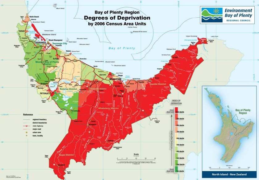
4.5.4 Indicator – deprivation index .............................................................................. 48
Part 5: Funding ........................................................................................................... 51
5.1 Sources of funding ............................................................................................. 51
5.2 Funding gaps and challenges ............................................................................ 52
Part 6: Conclusions .................................................................................................... 55
ii Transportation Publication 2011/03 – Bay of Plenty Regional Transport Trends and IssuesPart 1: Introduction
1.1 Background
This paper provides a summary of the key regional transport issues and trends to
support and inform the development of the Bay of Plenty Regional Land Transport
Strategy (RLTS).
The RLTS will be prepared in accordance with the requirements of the Land
Transport Management Act 2003 (LTMA). The information contained in this paper
includes indicators or measures that reflect the core LTMA requirements to be
considered when preparing the RLTS. These requirements are based on the
following transport outcomes:
Assisting economic development
Assisting safety and personal security
Improving access and mobility
Protecting and promoting public health
Ensuring environmental sustainability
The New Zealand Transport Strategy and the Government Policy Statement on land
transport funding are also aligned with these outcome areas.
1.2 Identifying and documenting regional transport trends and
issues
The trends and issues have been developed from a variety of sources including
consultant reports on specific issues such as freight, other reference documents and
input from consultation with reference groups, focus groups, regional advisory group1
and Regional Transport Committee.
Six reference groups were formed from industry and technical staff to provide input
on the issues and future outcomes sought for the region in the future. Workshops
were held with each of the groups to gain industry insight into current and future
transport issues in each of the outcome areas.
Funding was raised as an issue in all of the reference group workshops and a
separate section on funding has been included in this document to highlight some of
the issues raised and reflect the importance of this subject area for the development
of transport in the region.
Consultation was also undertaken through focus groups with residents from the three
sub-regional areas of western Bay of Plenty, Rotorua and eastern
Bay of Plenty. Meetings were held with focus groups in Tauranga, Rotorua and
Whakatāne and the participants were asked to provide their views on existing
transport issues and their vision for the future of the region for land use development
and transport implications.
1
The Bay of Plenty Regional Advisory Group has representatives from Kawerau District Council,
Ōpōtiki District Council, Rotorua District Council, Tauranga City Council, western Bay of Plenty District
Council, Whakatāne District Council, New Zealand Transport Agency.
Transportation Publication 2011/03 – Bay of Plenty Regional Transport Trends and Issues 3The outputs from the Community Outcomes Survey 2010 and the Regional Bus
Satisfaction Survey have also been used to provide community attitudes and
perceptions on transport issues in the region.
1.3 Report overview
The report is structured around the following outline:
Population and growth management
Regional outcomes
- Economic development
- Sustainability
- Integration and land use
- Safety and personal security
- Access and mobility
- Public health
Funding
Conclusions
For each of the regional outcome areas, a range of indicators have been described
along with a discussion on the potential transport implications for the region.
4 Transportation Publication 2011/03 – Bay of Plenty Regional Transport Trends and IssuesPart 2: Population and growth management
The forecast population growth in the Bay of Plenty region will increase future travel
demands. The extent of the projected population growth and consideration of
economic and employment activities is discussed below.
2.1 Population
2.1.1 Indicator – forecast population growth by region and sub-region
Figure 1 shows the actual resident population (between 1991 and 2006) and
projected population at the regional and sub-regional levels (refer to Map 1 below).
The regional population is forecast to grow by around 42% between 2011 and 2051
or by about 119,500 people. This is the equivalent of roughly adding the population
of another Tauranga City2 to the regional population.
2
Based on the sub national population estimates at 30 June 2006 – 2009 for Tauranga City Territorial
Authority http://www.stats.govt.nz/browse_for_stats/population/estimates_and_projections/subnational-
pop-estimates-tables.aspx
Transportation Publication 2011/03 – Bay of Plenty Regional Transport Trends and Issues 5Map 1 – Regional boundaries
Figure 1 Resident population, actual and projected, by sub-region
6 Transportation Publication 2011/03 – Bay of Plenty Regional Transport Trends and IssuesWestern Bay of Plenty Rotorua Eastern Bay of Plenty
450000
403320
400000
379850
350360
350000 333040
316710
300320
300000 283830
260808
250000 242601
227584
207266
200000
150000
100000
50000
0
1991 1996 2001 2006 2011 2016 2021 2026 2031 2041 2051
Year
Source: Census 1991-2006; Bay of Plenty Demographic Forecast 2051 ‘modified medium
variant’ projections.
The western Bay of Plenty sub-region has experienced strong population growth by
51% over the period 1991 to 2006. This is projected to increase by another 34% in
the next 15 years. The population of Rotorua is slowly increasing, while the eastern
Bay of Plenty population remains static. The steady population increase of 7-10% for
the whole region is driven by growth in the western Bay of Plenty.
The increase and distribution in population growth is aligned with a corresponding
increase in the number of households in each of the respective sub-regions (refer to
Figure 3 below).
Around 56% of the region’s population lives in the western Bay of Plenty sub-region,
with 25% in Rotorua and 19% in the eastern Bay of Plenty sub-regions.
Approximately 74% of the region’s population live in urban areas.
In contrast to the growth in the western Bay of Plenty, both Kawerau and Opotiki
districts experienced population declines over the same period.
Transport policy implications – forecast population growth by region and
sub-region
The projected population will underpin medium and longer term decisions on
transport related investment. The distribution of future population growth and
increase in households is likely to follow recent patterns of growth with the western
Bay of Plenty sub-region and urban areas experiencing the strongest levels of
growth. In the context of urban based growth, it is anticipated that additional
pressure will be placed on limited existing infrastructure. This may result in
increased peak period travel delays along key transport corridors and routes.
Conversely, the growth in urban areas will also present opportunities to increase the
(person) carrying capacity of routes through public transport initiatives and travel
demand management measures (e.g. car sharing, travel plans, etc).
Transportation Publication 2011/03 – Bay of Plenty Regional Transport Trends and Issues 7Transport demands in rural areas and smaller centres experiencing little or no
population growth will require essential services to be maintained. This includes the
maintenance of rural routes, upgrading unsealed roads3 and accommodating growth
in freight related traffic.
2.1.2 Indicator – population and demographic profile
Compared to New Zealand as a whole, the region has a higher percentage of people
in the under 15 and over 60 age groups. This population profile is indicated in
Figure 2 below showing the regional population by age cohort and sex.
(SOURCE: Statistics NZ, 2006 Census)
Figure 2 Total population (age group and sex) Bay of Plenty region, 2006
Census
Population forecasts indicate a substantial increase in the region’s elderly population.
The eastern Bay of Plenty sub-region and Rotorua district experience noticeable
changes in population structure rather than population size. In the western
Bay of Plenty sub-region changes to both the size and the structure of the population
will be key planning considerations.
The percentage of the population over 65 years old is projected to grow from 16% to
20%. In 2006 there were 39,200 people aged over 65 years (Statistics NZ). By 2021
the region is forecast to have approximately 60,900 people aged over 65 years in the
Bay of Plenty, and by 2031 there will be over 78,300 people over 65 years. All sub-
3
A substantial proportion of the western Bay of Plenty, Whakatane, Rotorua, and Opotiki rural road
networks are unsealed. The western Bay of Plenty district’s 225km of unsealed roads is the highest in
the region. The Tauranga and Kawerau local road networks contain negligible lengths of unsealed
road.
All four districts with unsealed roads are actively undertaking seal extension programmes, although at
different rates across the region. western Bay of Plenty district has achieved the largest reductions in
absolute terms over the past two years. Unsealed roads in the Whakatāne and western Bay of Plenty
districts carry the most traffic per kilometre. (RLTS Annual Report 2009/10)
8 Transportation Publication 2011/03 – Bay of Plenty Regional Transport Trends and Issuesregions, cities, and districts will be home to more people aged 65 years and over in
2031, and the Bay of Plenty will have the second highest average annual population
change (second only to Auckland).
15,000 10,000 5,000 0 5,000 10,000 15,000
80–84
70–74
60–64
50–54
Age groups
40–44
30–34
20–24
10–14
0–4
number of people in each category
2011 Female 2041 Female 2011 Male 2041 Male
Figure 3 Comparison of the number of people in the Bay of Plenty region in
each age group in 2011 and 2041 by gender. (Medium projection from
projections produced by Statistics New Zealand according to
assumptions agreed to by Bay of Plenty Regional Council. August
2010.)
Figure 3 shows that the increase in the Bay of Plenty population will be primarily in
the older age groups (70+ years).
Transport policy implications – population and demographic profile
The aging of the region’s population will lead to changes in the demand for various
public services, such as health facilities and transport. The young and elderly
segments of the population also correspond to the portion of the population often
without access to a car or who are unable to drive. The provision of viable transport
options will therefore be of greater importance to these segments of the population,
particularly the young and elderly located in isolated communities.
Related issues to the ageing population structure are the need to consider the
affordability of transport options and the safety of transport users. For example, the
increase in the number of elderly in the region suggests that the representation of
vulnerable road users will also rise. This will require transport planners and
providers to design and supply facilities that meet the needs of an ageing population.
Transportation Publication 2011/03 – Bay of Plenty Regional Transport Trends and Issues 92.2 Households
2.2.1 Indicator – household growth
Projections for household growth between 2006 and 2031 by territorial authority are
shown in Figure 3 below. The projections are based on the medium growth scenario
and further assumptions were made regarding the proportion of households within
the Rotorua and Taupo districts4 which both overlap with more than one regional
council.
The growth in households mirrors the trend in population growth with Tauranga city
and western Bay of Plenty experiencing the greatest increase in the number of
households. A more moderate rate of household growth is expected in Rotorua
district while the level of household growth in Kawerau and Opotiki districts is
projected to remain flat. This reflects wider trends around the movement of people to
larger urban areas and hence the demand for households where there may be
greater economic opportunities compared with smaller centres in the region.
Over time, it is expected that average household sizes will be smaller5 with the
growth in households being greater than the projected increase in the number of
families and the population. The Bay of Plenty region is projected to have the third
highest percentage increase in number of households (35 %) after the Auckland
(46%) and Tasman (40%) regions6.
Household Projections by TA
70,000
60,000
50,000
2006
Households
2011
40,000
2016
2021
30,000
2026
2031
20,000
10,000
0
Taupo district Western Bay of Tauranga city Rotorua district Whakatane Kawerau district Opotiki district
Plenty district district
(SOURCE: Statistics NZ)
Figure 3 Household projections by territorial authority 2006 to 2031
4
A figure of 15% of households for Taupo and 60% of households within Rotorua were assumed to be
within the Bay of Plenty Regional area for the purposes of presenting regional data.
5
The regional average household size has reduced from 2.79 in 1991 to 2.62 in 2006.
6
‘Demographic Forecast 2051,Movement and change in population and households in the Bay of
Plenty Demographic Forecast 2051’, Strategic Policy Publication 2006/01, August 2006 prepared by
the Migration Research Group, The University of Waikato for the Bay of Plenty Regional Council,
Bay of Plenty Regional Council
10 Transportation Publication 2011/03 – Bay of Plenty Regional Transport Trends and IssuesTransport policy implications – household growth
The growth in households and the changes in the average size of households, will
present opportunities and challenges in regard to servicing the transport demands of
more and potentially smaller households, for the western Bay of Plenty and
Tauranga city in particular. Improving the co-ordination between transport and land
use planning will require greater emphasis in the region’s urban areas. At the macro
level the distribution of households and capacity of transport and other infrastructure
to support the additional households is a fundamental consideration. Planning and
providing for transport options such as public transport between significant origins
and destinations is an example implementing wider integration objectives. This
includes the potential to consolidate growth in households along existing and
established transport routes and corridors and the coupling of smaller households
with compatible non-residential uses or activities.
In the short to medium term, the majority of growth is anticipated to be taken up by
infill in existing residential areas and the development of greenfields sites on the
edges of existing urban areas. The greenfield sites offer the opportunity to provide
residential areas that offer a high level of connectivity for walking and cycling and the
provision of efficient public transport routes. The planning and provision of public
transport should be co-ordinated early on in the development of greenfield sites to
reduce patterns of car dependency.
While densification is part of the planning tool kit to provide for continued growth
there has been market resistance to planning provisions for development of medium
density areas and this is now considered to be a longer term goal.
Parking policy will also need to be considered in terms accommodating the future
growth in households in the Bay of Plenty’s urban areas. This may require balancing
the demand management and urban design objectives (e.g. influencing travel
behaviour through the availability, cost and supply of parking and street design)
against the practical and commercial benefits of providing parking in the context of
increasing households (e.g. retaining parking for smaller households to support
‘lifestyle’ choices and preferences).
2.3 Business and employment
2.3.1 Indicator – employment trends and growth
Recent trends in employment numbers by business sector over the last decade are
shown in Figure 4 below. Figure 4 indicates the dominant business sectors in the
region as reflected by the employee numbers. The dominant sectors in terms of
employee numbers are manufacturing, retail trade and health care and social
assistance. Both manufacturing and retail trade experienced a sharp decline in
employee numbers between 2008 and 2009. This decline coincides with the period
of the global financial crisis. Other sectors to experience a noticeable decrease in
employee numbers over this period include construction and accommodation / food
service. The decline in these sectors was also a result of the global downturn with
less new development occurring and a reduction in discretionary spending for
households in favour of reducing debt levels.
Conversely, the health care, education and agriculture sectors experienced
increases in employee numbers over the period of the recent global financial crisis
with the health care sector being the largest sector in the region by employee in
2009. The impacts of the recent economic downturn as indicated in the Bay of
Plenty’s employment numbers by sector was a national trend.
Transportation Publication 2011/03 – Bay of Plenty Regional Transport Trends and Issues 11The region contains one of the biggest concentrations of plantation forests in the
country, with 13% of New Zealand’s exotic plantation forestry (215,340 hectares)
employing 22% of the country’s forestry workforce. The processing and manufacture
of wood products and paper and paper products are also important areas of
employment in the region.
The region produces about 80% of the national kiwifruit production and the region
contains about 30% of New Zealand’s citrus production area. It is also one of the
dominant regions for nashi, avocados, feijoas and passionfruit.
Employee count by sector 2000 - 2009 Bay of Plenty Region
16,000
15,000
14,000
13,000
Agriculture, forestry & fishing
12,000 Mining
Manufacturing
11,000 Electricity, gas, water & waste services
Construction
10,000
Wholesale trade
No. of employees
9,000 Retail trade
Accommodation & food services
8,000 Transport, postal & warehousing
Information, media & telecommunications
7,000 Financial & insurance services
Rental, hiring & real estate services
6,000 Professional, scientific & technical services
Administrative & support services
5,000
Public administration & safety
Education & training
4,000
Health care & social assistance
3,000 Arts & recreation services
Other services
2,000
1,000
0
2000 2001 2002 2003 2004 2005 2006 2007 2008 2009
SOURCE: Statistics NZ, ANZSIC and Size Group (Annual-Feb), Employment Count,
Bay of Plenty
Figure 4 Bay of Plenty Region Employee Count by Sector 2000 -2009
Transport policy implications – employment trends and growth
The employee count by sector reflects broader trends in economic activity and these
are discussed in regard to two main areas of transport policy. The first is in relation
to the movement of goods that is directly influenced by the level of business activity
associated with each of the respective sectors. This includes the movement of
goods as part of the production supply chain for both the local and international
markets. Agriculture, forestry and fishing is one sector that has demonstrated robust
levels of activity through the recent global financial crisis and this sector is expected
to continue to contribute to the Bay of Plenty’s economic activity in the future.
Agriculture, the development of aquaculture and other export orientated sectors will
continue to rely on the efficient and timely delivery of goods to the Port of Tauranga.
Rural state highways make up part of this wider network and the maintenance of
12 Transportation Publication 2011/03 – Bay of Plenty Regional Transport Trends and Issuesthese routes is an on-going policy consideration along with capital investment in key
routes (e.g. Tauranga Eastern Link). Freight and heavy vehicle related movements
form a core component of goods related journeys in the region. Policy
considerations include the development and maintenance of a freight priority network
that is supportive of overweight and over dimension vehicles and is aligned with the
main freight demands. The continued development and maintenance of the rail
system in the region is also essential for the efficient and effective intra and inter
regional movement of goods. Figure 8 provides an overview of freight related flows
to and from the region.
The second broad policy consideration is the movement of people and the impact of
transport to facilitate participation in the region’s economy. Figure 4 indicates strong
growth trends in the healthcare and education sectors. These sectors often involve
travel that occurs outside of conventional peak periods and comprise a higher share
of shift based work and/or casual labour. The accommodation and food service
sector also shares similar characteristics but has recently declined as a result of the
global financial crisis. Transport issues will include the need to accommodate both
peak period travel and off-peak demand generated by employees and those
participating in the healthcare (e.g. outpatients and visitors) and education sectors
(e.g. students).
The retail sector is also an essential aspect of the region’s economy and while there
has been a drop in employment in this area due to the global economic downturn, it
is expected that this sector will continue to grow in the medium to long term. The
region’s CBD’s are an essential component of the urban areas and transport policy
needs to support growth and development in these areas such as through parking
policy (e.g. no minimums) and focussing public transport on the central business
districts as key employment centres. Transport policy can therefore support the
potential economic benefits of agglomeration in CBD areas.
The importance of horticulture and forestry to the region’s economy also suggests
that there is a seasonal and itinerant workforce that generates its own set of
transport demands
.
Transportation Publication 2011/03 – Bay of Plenty Regional Transport Trends and Issues 13Part 3: Regional outcomes
3.1 Economic development
The region’s transport network and system will support economic growth and
employment. The efficient movement of goods, services and people is an integral
part facilitating economic growth and activity in the region. In the Bay of Plenty
region the movement of freight is recognised as a key component in supporting
economic activity. Freight related indicators are described and discussed below
along with tourism and congestion indicators.
3.1.1 Indicators – growth in freight traffic
Internal freight movements in the region as shown in Figure 5 are predicted to grow
with the main areas of demand being:
Growth in logs and timber products;
Growth in horticulture, mainly driven by kiwifruit;
Constant level of dairy activity; and
Increase in movements of aggregates and limestone, fertiliser and other
building materials
Although not included in these figures, aquaculture is also predicted to grow
significantly in the eastern Bay of Plenty sub-region.
25
20
Million tonnes pa
15
10
5
0
2006-07 2031
Dairy Products Logs and Timber Products
Meat and Livestock Horticulture
Petroleum Coal
Aggregate Limestone, Fertiliser, Cement & Concrete
Other Minerals and Metals Retailing and Couriers
(SOURCE: Bay of Plenty Regional Freight Study 2010)
Figure 5 Growth in freight movements, 2006/07 to 2031- selected commodities
Transportation Publication 2011/03 – Bay of Plenty Regional Transport Trends and Issues 15The current and predicted modal split for freight movements is shown in Figure 6,
with the estimates being based on a ‘business as usual’ approach. The major
increase in freight movement is predicted to be by road transport. Increases in the
quantities of freight carried by rail and coastal shipping are also forecast to grow
against existing levels. These increases in rail and coastal shipping are mainly the
result of the overall forecasted increases in freight movements.
60
50
Million tonnes per year
40
30
20
10
0
2006-07 2031 2040
Rail Coastal Shipping Road
(SOURCE: Bay of Plenty Regional Freight Study 2010)
Figure 6 Forecasts of Regional Freight Movements by Mode, 2006/07 to 2040
(million tonnes)
The overall position is one of substantial growth with forecast volumes of freight
traffic increasing by almost two thirds and with rail traffic increasing its modal share
(as shown in Table 1 below). Although the increase in modal share is small, the
underlying growth in the overall market implies a substantial growth of rail traffic
within the region.
Internal flows are forecast to increase strongly reflecting the growth of logs and
timber, aggregates and building materials and horticulture as shown in Figure 5. The
rail modal share is forecast to increase, mainly reflecting the growth of log and timber
movements, where rail is heavily involved in the transport of these products.
Inter-regional flows with other Upper North Island regions are forecast to grow less
quickly, reflecting the cessation of coal related traffic and also the anticipated
changes in distribution patterns. For example, more direct delivery to areas away
from the Upper North Island reducing the volumes imported through Tauranga to
national distribution centres in Auckland. The growth in inter-regional freight
movement is likely to be dependent on future port upgrades for larger container ships
visiting New Zealand and this is discussed further in Section 3.1.2.
While some overall growth in rail traffic to 2040 is forecast, its share of the total is
predicted to decline under a business as usual approach. The share of coastal
shipping is expected to increase with the growth of petroleum and cement
movements from Northland. The share of road freight is expected to remain broadly
unchanged.
Other external movements are expected to grow by about 45%, below the average
for the region as a whole. The rail share is forecast to grow slightly and coastal
shipping by slightly more, although the volumes by both these modes are expected
to remain small relative to the amount of freight carried by road.
16 Transportation Publication 2011/03 – Bay of Plenty Regional Transport Trends and IssuesTable 1 Forecasts of growth in freight movements to 2040 - total flows by type
of movement (million tonnes)
Total Rail Coastal Shipping Road
Type of
Year Modal Modal Modal
movement
M tonnes M tonnes share M tonnes share M tonnes share
2006-07 17.4 1.4 8% 0.0 0% 16.0 92%
NFDS to 2031 29.1 2.9 10% 0.0 0% 26.2 90%
Internal
2040 31.4 3.2 10% 0.0 0% 28.2 90%
Inc to 2040 181% 234% 130% 0.0 0% 176% 0.975
Inter- 2006-07 11.2 3.3 29% 0.5 4% 7.4 66%
Regional
NFDS to 2031 15.2 3.7 24% 1.2 8% 10.3 68%
within upper
North Island 2040 16.0 3.8 24% 1.3 8% 10.9 68%
Regions Inc to 2040 143% 116% 81% 288% 201% 146% 102%
2006-07 3.2 0.2 6% 0.1 3% 2.9 92%
Other NFDS to 2031 4.3 0.3 6% 0.1 3% 3.9 91%
Regions 2040 4.5 0.3 6% 0.2 4% 4.1 91%
Inc to 2040 142% 146% 103% 187% 132% 140% 99%
(SOURCE: Bay of Plenty Regional Freight Study 2010)
Heavy vehicle movements (as shown in Figure 7) on the individual components of
the state highway network in the Bay of Plenty and on the network as a whole, have
typically increased only very modestly since 2002, with the exception of the flows
through Te Puke, possibly reflecting growth in the kiwifruit harvest. The predicted
increases in road freight movements are likely to lead to substantial increases on
individual elements of the network in the future, even with the development of
alternative routes, such as the Tauranga Eastern Link.
2500
2000
SH2 Te Puna
Heavy Vehicle AADT
SH2 Te Puke
1500 SH2 Ohinepanea
SH5 Waipa
SH27 Kaihere
SH29 Kaimai
SH30 Te Nga
1000
SH30 Lake Rotoma
SH33 Pengaroa
Average BOP
500
0
2002 2003 2004 2005 2006 2007 2008 2009
SOURCE: Bay of Plenty Regional Freight Study 2010)
Figure 7 Heavy vehicle flows on state highways in the Bay of Plenty region
Transportation Publication 2011/03 – Bay of Plenty Regional Transport Trends and Issues 17Transport policy implications – growth in freight traffic
The growth in future freight traffic indicates a predominance of primary production
related goods (horticulture, logs and dairy). Moving these goods to overseas
markets reinforces the importance of having a freight network with strategic routes to
service the Port of Tauranga.
The increase in the movement of logging and timber products is expected to be a
major source of demand for freight traffic. Logging related trips are expected to be a
major contributor to the increase in the share of rail based freight trips. Rail also has
an important role in the movement of cargo between Tauranga and Auckland via the
MetroPort inland port facility (refer to Figure 8 showing freight flows between the
Bay of Plenty Region and other regions).
18 Transportation Publication 2011/03 – Bay of Plenty Regional Transport Trends and Issues1 million tonnes
3 million tonnes
(SOURCE: Bay of Plenty Freight Study 2010)
Figure 8 Pattern of total freight flows to and from Bay of Plenty 2006/07 (million
tonnes)
The implications of additional freight related movements include the need to identify
a coherent freight network that connects key freight generating activities in the
region. Coupled with the route identification are the on-going operational
maintenance of these routes and requirements to accommodate overweight and over
dimension freight vehicles. Other policy considerations include avoiding high volume
freight movements through sensitive areas (e.g. residential) to minimise potential
traffic / modal conflicts and environmental effects and opportunities to better utilise
rail for intra and inter-regional freight movement.
Transportation Publication 2011/03 – Bay of Plenty Regional Transport Trends and Issues 193.1.2 Indicator – port related freight traffic
The Port of Tauranga is New Zealand’s largest port by volume (13.5 m tonnes per
annum) and the second largest container port (546,000 TEUs7). The port is strategic
infrastructure for the Bay of Plenty region and New Zealand providing a major
international link for the country’s imports and exports.
The volumes of both imports and exports have fluctuated over the preceding decade
although total import/export flows through the Port of Tauranga have increased by
over 18% since 2002. Refer to Figure 9 showing the volume of freight traffic through
the Port.
The fluctuations reflect changes in the level of market demand leading to changes in
volumes of commodities harvested or produced, particularly for logs and timber,
which accounts for 60% of exports. These volumes have also been affected by the
costs and availability of shipping services to the main markets.
Other factors that have contributed to the fluctuations are the changes in demand for
imports of basic commodities such as coal, the growth of imports of palm kernels
(from nothing in 2006 to 0.4-0.5 million tonnes in 2008 and 2009) and the effects of
the economic downturn, particularly for manufactured goods and fertiliser bases
reflected in the reduction of TEU’s in 2009.
Changes in the patterns of shipping services, particularly affecting the balance
between the ports of Auckland and Tauranga, has affected the volumes of dairy
products and other containerised cargo through the port.
16
14
12
Million Tonnes
10
8
6
4
2
0
2002 2003 2004 2005 2006 2007 2008 2009
Year ended 30 June
Imports Exports
(SOURCE: Bay of Plenty Regional Freight Study, 2010)
Figure 9 International freight traffic through the Port of Tauranga
7
Twenty foot equivalent containers
20 Transportation Publication 2011/03 – Bay of Plenty Regional Transport Trends and IssuesTransport policy implications – port related freight traffic
The trend towards larger ships visiting fewer ports is likely to further change freight
distribution patterns, due to potential changes to off-site storage of such commodities
as logs and more ‘just in time delivery’. This may lead to localised transport issues
with more defined peaks when these ships are in port.
As noted above, the growth in future import and export freight traffic reinforces the
importance of having a freight network with strategic routes to service the
Port of Tauranga.
3.1.3 Indicator – growth in tourism sector
The key trends in regional tourism growth for the Bay of Plenty Regional Tourism
Organisation (RTO) area are shown in Figure 10 and include the following:
Total visits by travellers to the Bay of Plenty RTO area are forecast to rise from
3.49 m in 2008 to 3.69 m in 2015 - an increase of 5.6% (194,900) or 0.8% p.a.
International visits are expected to increase from 255,900 in 2008 to 297,500 in
2015, representing growth of 41,600 or 16.2%. The share of total visits
generated by international visitors is expected to increase from 7.3% to 8.1%.
Domestic visits are expected to increase from 3.24 m in 2008 to 3.39 m in
2015, representing growth of 153,400 or 4.7%. The share of total visits
generated by domestic visitors is expected to decrease from 92.7% to 91.9%.
14,000,000
12,000,000
10,000,000
8,000,000
Domestic
International
Total
6,000,000
4,000,000
2,000,000
0
2003 2004 2005 2006 2007 2008 2009f 2010f 2011f 2012f 2013f 2014f 2015f
Domestic 10,297,54 9,845,242 9,486,459 9,469,992 8,949,665 9,326,864 9,474,802 9,645,692 9,687,204 9,669,655 9,670,758 9,687,385 9,703,274
International 1,479,847 1,520,925 1,534,533 1,588,768 1,597,253 1,662,324 1,586,750 1,604,605 1,698,310 1,736,000 1,791,146 1,846,496 1,904,431
Total 11,777,38 11,366,16 11,020,98 11,058,75 10,546,91 10,989,18 11,061,54 11,250,29 11,385,50 11,405,64 11,461,89 11,533,87 11,607,70
(SOURCE: Ministry of Tourism)
Figure 10 Tourism numbers for Bay of Plenty
The key trends in regional tourism growth for the Rotorua RTO area are shown in
Figure 11 and include the following:
Total visits by travellers to Rotorua RTO are forecast to rise from 3.04 m in
2008 to 3.31 m in 2015 - an increase of 9.0% (272,100) or 1.2% p.a.
Transportation Publication 2011/03 – Bay of Plenty Regional Transport Trends and Issues 21 International visits are expected to increase from 849,300 in 2008 to 1.02 m in
2015, representing a growth of 167,200 or 19.7%. The share of total visits
generated by international visitors is expected to increase from 28.0% to
30.7%.
Domestic visits are expected to increase from 2.19 m in 2008 to 2.29 m in 2015,
representing growth of 104,900 or 4.8%. The share of total visits generated by
domestic visitors is expected to decrease from 72.0% to 69.3%.
12,000,000
10,000,000
8,000,000
Domestic
6,000,000 International
Total
4,000,000
2,000,000
0
2003 2004 2005 2006 2007 2008 2009f 2010f 2011f 2012f 2013f 2014f 2015f
Domestic 7,089,306 6,676,699 6,444,996 6,426,449 6,001,005 6,208,503 6,308,502 6,425,351 6,461,397 6,452,243 6,451,061 6,461,102 6,470,540
International 2,984,603 3,099,528 3,103,328 3,153,513 3,162,166 3,134,968 2,889,980 2,989,251 3,208,577 3,287,242 3,419,600 3,551,022 3,686,004
Total 10,073,90 9,776,225 9,548,323 9,579,960 9,163,169 9,343,470 9,198,481 9,414,600 9,669,972 9,739,484 9,870,659 10,012,12 10,156,54
(SOURCE: Ministry of Tourism)
Figure 11 Tourism numbers for Rotorua
Transport policy implications – growth in tourism sector
The success and capacity of the tourism sector to sustain growth is underpinned by
transport systems that facilitate international and domestic travel across all modes
(i.e. planes, ferries/ships, buses, cars, cycling and walking). Providing efficient,
pleasant and comfortable transport facilities (including inter-changes) and services is
essential to supporting the tourism sector. This includes providing a high level of
service for transport related transfers or transitions between modes at key
locations/nodes.
There are also seasonal considerations in regard to the demand for tourist related
travel with the summer months representing the peak period. An example of this is
to co-ordinate construction activity over the peak period to minimise potential delays
and conflicts for tourist related travel.
22 Transportation Publication 2011/03 – Bay of Plenty Regional Transport Trends and Issues3.1.4 Indicator – travel delays on congested routes
Travel delay on key selected routes8 in Tauranga (minutes delay per km) provides a
measure of congestion. Figure 12 indicates a general trend of reduced travel time
delays in Tauranga over the past five years. Auckland data has been included for the
purpose of comparison. The travel figures for the 2009/10 year have shown
significant increases in vehicle travel speeds for all periods of the day as the final
elements of the Harbour Link project have been completed and come on-line.
Travel time delays on the Tauranga network stabilised at approximately 0.35 minutes
per km in 2006 to 2008 and have since decreased significantly with the completion of
the Harbour Link Project.
Weekday AM peak Weekday PM peak Weekday daily average Auckland daily average
0.70
0.60
0.50
Minutes delay
0.40
0.30
0.20
0.10
0.00
March 05 March 06 March 07 March 08 March 09 March 10
Year
(Source NZ Transport Agency Travel Time Performance Indicators Report)
Figure 12 Vehicle travel speeds on key congested routes in Tauranga
Transport policy implications – Travel delays on congested routes
The estimated population growth expected to occur within the region will place
greater pressure on the region’s transport network and resources. A ‘business as
usual’ approach coupled with this anticipated population growth and rising levels of
vehicle ownership will lead to a worsening in future congestion along key routes.
Travel delays will impact on journey time reliability for public transport, freight and
private vehicle movements. There is a need for transport policy to build in greater
diversity and choice in the region’s transport options for freight and people. The
reality of funding constraints and dispersed nature of smaller centres in the region
will however require a targeted approach to the prioritisation and safeguarding of
transport initiatives. For example, to manage the congestion related effects of traffic,
8
Route 1 - State Highway 2 and State Highway 33, Route 2 - State Highway 29 and the Harbour
Bridge, Route 3 - Cameron Road and Marsh Street, Route 4 - Cambridge Road, Route 5 - Takitimu
Drive, Route 6 - Fraser Street, 11th Avenue, Devonport Road, The Strand, and Dive Crescent, Route 7
- Maunganui Road, Rata Street and Totara Street, Route 8 - Domain Road, Papamoa Beach Road,
Maranui Street and Girven Road.
Transportation Publication 2011/03 – Bay of Plenty Regional Transport Trends and Issues 23the people carrying capacity may become an important driver along certain routes
while freight and general traffic is identified as a priority along other parts of the
region’s transport network, including rail.
24 Transportation Publication 2011/03 – Bay of Plenty Regional Transport Trends and IssuesPart 4: Sustainability
Safeguarding the quality of the environment and managing the potential adverse
environmental effects resulting from the implementation and ongoing operation of the
transport network is a key policy outcome area. These are reflected in the macro level
discussion below on oil prices and other indicators highlighting the use of non-renewable
energy resources and levels of sustainable transport modes (walking, cycling and public
transport).
4.1 Indicator – energy use and oil prices
Energy use in New Zealand is dominated by transport and the country is reliant on
imported oil for almost half of our energy needs, making us vulnerable to
international supply disruption and volatile oil prices.
The real price of oil has been subject to fluctuations and has increased significantly
from 2002 to 2008. More recently the economic downturn has resulted in a decrease
in oil prices. As shown in Figure 13, in the medium to long-term prices are
anticipated to plateau and possibly decline slightly, but remain at historically high
levels. Beyond 2028 oil prices are expected to increase sharply as accessible world
supplies diminish.
(SOURCE: Price Forecasts for Transport Fuels and other Delivered Energy Forms, MR Cagney 2009)
Figure 13 Oil price forecasts and associated error bounds 2008-2060
The concept of Peak Oil is relevant to the above scenario of increasing oil prices and
diminishing supply. Peak Oil is the point beyond which depletion of existing supply
exceeds the development of new supply. As shown in Figure 13, this will lead to
increasing costs as relatively accessible petroleum supplies are depleted. Petroleum
Transportation Publication 2011/03 – Bay of Plenty Regional Transport Trends and Issues 25is not expected to suddenly run out but is likely to become more expensive as
demand grows and production costs rise. Growing economies reliant on oil imports
will either need to import more oil or produce more fuel from alternative sources such
as deep ocean wells, biofuels, tar sands and liquefied coal.9
Transport policy implications – energy use and oil prices
The recent volatility of fuel prices and the long term forecast increase in oil based
fuels highlights the need to develop a transport system that is resilient to future price
changes. This will involve planning for energy efficient modes of transport including
public transport, walking and cycling and rail freight.
The rising price of fuel can also function as a de-facto economic based demand
management measure. The situation of rising fuel prices can create an incentive for
some people to seek alternative and cheaper forms of transport. It is important that
affordable travel options and alternatives are available to support the development of
a resilient transport system.
It is recognised however that travel by private vehicles and heavy vehicles will
continue to have an important role in supporting the transport needs of the region.
The development of more fuel and engine efficient technology options and new forms
of transport energy for private and freight vehicles will contribute to improvements in
energy use.
4.1.1 Indicator – mode split journey to work
As a corollary to the above discussion on developing a resilient transport system,
Figure 14 shows regional journey to work data by mode. The census information
between 1996 and 2006 indicates continued growth in the share of motor vehicle
commuting. The share of walking and cycling trips has gradually eroded while the
share of public transport journeys has increased slightly off a low base. The share of
public transport journeys lags well behind other sustainable modes such as walking
and cycling.
The journey to work data is useful in that trends can be identified over a period of
time. However, the data is also limited in that it only represents a discrete segment
of work related journeys that are undertaken in the morning peak and does not
include other non-work trips (e.g. education or recreational) or other journeys taken
outside of the morning peak period. These other peak and off-peak non-work trips
may have a greater share of walking, cycling and public transport journeys and in
some cases could also have higher vehicle occupancy rates that the typical morning
journey to work.
9
‘Transportation Cost and Benefit Analysis II – Resource Consumption External Costs’, by Todd
Litman, Victoria Transport Policy Institute, June 2010
26 Transportation Publication 2011/03 – Bay of Plenty Regional Transport Trends and IssuesMotor vehicle Public Transport Cycling Walking Motorcycle Other
100%
2.2% 1.6% 1.5%
5.9% 5.1%
6.8%
90% 3.3% 2.4%
4.7% 0.5% 0.8%
0.5%
80%
70%
60%
50%
88.0% 89.5%
84.8%
40%
30%
20%
10%
0%
1996 2001 2006
Year
(SOURCE: Census 1996-2006, Statistics New Zealand)
Figure 14 Bay of Plenty mode split for travel to work
Table 2 indicates the mode share by district / city based on 2006 journey to work
Census data. Travel by motor vehicle was most dominant in the urban areas of
Tauranga and Rotorua and in the western Bay of Plenty district. Tauranga and
Rotorua also recorded the highest proportions of public transport use, although mode
share was still only around 1% of journeys to work in these districts. The table also
shows that the ‘active modes’ (walking and cycling) retained the largest mode share
in the eastern Bay of Plenty districts with smaller urban or rural based populations
(i.e. Whakatane, Kawerau and Opotiki). These centres with the highest share of
active modes also not unexpectedly correspond to the centres with the highest
percentage of households without access to a car.
Table 2 Mode split for travel to work in 2006, by district/city
Local Mode
authority Motor Public Motor
Cycling Walking Other
vehicle Transport cycle
Western Bay of
Plenty 91.6% 0.4% 1.0% 4.5% 1.8% 0.7%
Tauranga 90.3% 1.0% 2.6% 4.3% 1.1% 0.6%
Rotorua 89.2% 1.3% 2.3% 5.1% 1.5% 0.6%
Whakatane 86.2% 0.2% 3.2% 7.3% 2.6% 0.6%
Kawerau 84.9% 0.0% 3.8% 9.0% 1.7% 0.6%
Opotiki 86.6% 0.5% 1.9% 7.9% 2.6% 0.5%
Region 89.5% 0.8% 2.4% 5.1% 1.5% 0.6%
(SOURCE: Census 2006, Statistics New Zealand)
Transportation Publication 2011/03 – Bay of Plenty Regional Transport Trends and Issues 27Transport policy implications – mode split journey to work
The mode split data reinforces the increasing reliance on private motor vehicle use
for commute related travel to urban areas in the region. For example, Tauranga and
Rotorua are key employment areas for the western Bay of Plenty district. The longer
distance of journeys from the wider western Bay of Plenty catchment to the urban
areas of Tauranga and Rotorua, suggests a greater reliance on private cars. The
viability of providing cost effective transport options for such journeys is often low
given the dispersed nature of households. There are however, opportunities to
consider demand management measures such as work place based travel planning
and car sharing options.
The low proportion of journeys to work by public transport in urban areas suggests
that there is scope and opportunity to significantly improve the mode share of public
transport. This will require co-ordinated land use, appropriate parking and public
transport policy development, to ensure that future growth and of investment in public
transport infrastructure and services are mutually supportive.
4.1.2 Indicator – fuel sales
Figure 15 shows fuel sales over the period 2000/01 to 2008/09 with the highest
recorded level in sales over this period being in 2006/07. Since this peak, there have
now been two consecutive years of decreasing fuel sales, with a 4% drop between
2007/08 and 2008/09. Fuel sales have shown a slight increase in 2009/10 following
this two year decrease. Diesel continues to account for slightly more than 50% of
sales in the Bay of Plenty, comprising 53% of all fuel sales in 2008/09.
The recent downward trend in fuel sales has coincided with continued population
growth and increases in the region’s vehicle fleet. While this may point to
improvements in fuel efficiency, other indicators suggest that there has been a
general decrease in travel demand over the same period. For example, traffic
volumes on key congested routes have for the most part decreased in the past year.
Socio-economic indicators also point to a general easing of activity associated with
the period of economic recession. Population growth in the region has slowed
relative to previous periods and it is likely that as the country moves out of recession
the upward trend in sales will return, despite increased vehicle efficiencies.
28 Transportation Publication 2011/03 – Bay of Plenty Regional Transport Trends and IssuesPetrol Diesel
600,000,000
500,000,000
400,000,000
Litres
300,000,000
200,000,000
100,000,000
0
2000/01 2001/02 2002/03 2003/04 2004/05 2005/06 2006/07 2007/08 2008/09 2009/10
Year
(SOURCE: Derived from sales figures collected for taxation purposes)
Figure 15 Quantity of fuel sold in the Bay of Plenty
Transport policy implications – fuel sales
There is a link between the level of fuel sales and the price of fuel (Figure 13), with
the decline in fuel sales corresponding to the period of increasing fuel prices
(2008/09). This relationship illustrates the role of economic factors in influencing the
demand for vehicle trips. Fuel sales and the price of fuel are determined by ‘external’
factors that are beyond the influence of regional transport policy. It is however,
recognised that a broad based transport system with investment in multiple modes
will be in a better position to absorb the flow-on effects of fluctuations in fuel use and
price.
Fuel sales are also a direct reflection of the wider environmental outcomes
associated with transport activities in regard to greenhouse gas emissions. At the
national level, the contribution of transport related emissions has significantly
increased over the past 20 years and in 2008 made up 18% of New Zealand’s total
emissions. With the introduction of greenhouse gas reduction targets through the
New Zealand Transport Strategy and Government Policy Statement, regional policy
needs to reflect transport processes, methods and priorities that help to achieve
these targets.
4.2 Transport and land use integration
Land use planning initiatives are a potentially influential demand management policy
when considered in conjunction with the provision of transport infrastructure and
services. The diversity, density, location and design of land use activities can often
provide the conditions for high levels of accessibility in terms of the opportunities to
access different transport options. The relationship between land use planning and
transport is discussed in terms of access to public transport facilities, inter-district
travel patterns and the distribution of residential building consents.
Transportation Publication 2011/03 – Bay of Plenty Regional Transport Trends and Issues 294.2.1 Indicator – percentage of population living within 500 metres of a bus
stop
Data on public transport coverage as presented in Table 3 was collected for the first
time in 2006/07, to provide a baseline figure for future reporting. Figures for the
subsequent two years show that public transport accessibility has been maintained
over the reporting period. The slight variation between years in Tauranga and
Rotorua can be attributed to minor changes to urban boundaries and bus routes.
The figures show that a high proportion of both the Tauranga and Rotorua urban
populations live close to a public transport access point. The complex geography of
Tauranga means that some smaller, less intensively populated areas in the city do
not currently have ready access to public transport services. In contrast, Rotorua’s
relatively compact urban core allows greater accessibility to be achieved with current
levels of service provision. For the first time in 2009/10 the report measured the
percentage of population living near a bus stop (rather than a bus route) in Rotorua.
Rotorua passengers must now board at a bus stop as the hail and ride system is no
longer applicable.
Public transport accessibility is also improving in the eastern Bay of Plenty. The
smaller, more dispersed populations in the eastern Bay of Plenty make it difficult to
achieve high levels of accessibility with a traditional public transport service provision
model. However, the eastern Bay of Plenty services do achieve a broad geographical
coverage, albeit at a low frequency.
Area 2006/07 2007/08 2008/09 2009/10
Tauranga urban area 85.0% 86.9% 83.6% 85%
10
Rotorua urban area - 95.2% 94.3% 91%
Eastern Bay of Plenty 15.1% 28.0% 28.0% 34%
(SOURCE: Environment Bay of Plenty, Tauranga City Council and Statistics New Zealand)
Table 3 Percentage of population living within 500 m of a bus stop
Transport policy implications – percentage of population living within 500 m of
a bus stop
The percentage of population living within 500 m of a bus stop provides a high level
indication of public transport coverage. This indicator broadly suggests that the
majority of the population within the Tauranga and Rotorua urban areas is serviced
by some form of bus service. When considered in conjunction with other indicators
such as the public transport mode share (Figure 14 and Table 2), it is apparent that
there is a range of other policy factors that need to be progressed to translate this
high level of accessibility into public transport trips. These include better matching
trip origin and destination profiles with service improvements and developing
complementary demand management measures. Improvements in the quality,
performance and attractiveness of public transport options are required as an
incentive to achieve a shift from private vehicles to public transport. These
improvements need to be balanced against affordability and funding considerations.
10
Rotorua operated a hail and ride system until 2010. Previously the report measured the proportion of the urban
population living within 500m of a bus route. The accessibility measure has changed for the latest reporting period
and is now consistent with the other two sub-regions.
30 Transportation Publication 2011/03 – Bay of Plenty Regional Transport Trends and IssuesYou can also read